APPENDIX H TOWN OF FARMVILLE. Hazard Rankings. Status of Mitigation Actions. Building Permit Data. Future Land Use Map. Critical Facilities Map
|
|
|
- Colleen Sullivan
- 5 years ago
- Views:
Transcription
1 APPENDIX H TOWN OF FARMVILLE Hazard Rankings Status of Mitigation Actions Building Permit Data Future Land Use Map Critical Facilities Map Zone Maps
2 Hazard Rankings (From Qualitative Assessment and Local Input) Hazard Likelihood Spatial Extent Potential Impact HAZARD RATING Hurricanes and Tropical Storms Winter Storms Drought Earthquakes Severe Thunderstorms and Tornadoes Erosion Wildfire Dam/Levee Failure Landslides Sinkholes Hazard rankings are based on a qualitative assessment, as described below. The values assigned for each option chosen are added together for each hazard to arrive at a total score. Assigned Value Definition Likelihood of Occurrence Highly Likely 3 Near 100% annual probability Likely 2 Between 10 and 100% annual probability Possible 1 Between 1 and 10% annual probability Unlikely 0 Less than 1% annual probability Spatial Extent Large 3 More than 50% of area affected 2 Between 10 and 50% of area affected Small 1 Less than 10% of area affected Potential Impact Catastrophic 4 Critical 3 Limited 2 Minor 1 High number of deaths/injuries possible. More than 50% of property in affected area damaged or destroyed. Complete shutdown of facilities for 30 days or more. Multiple deaths/injuries possible. More than 25% of property in affected area damaged or destroyed. Complete shutdown of facilities for more than one week. Minor injuries only. More than 10% of property in affected area damaged or destroyed. Complete shutdown of facilities for more than one day. Very few injuries, if any. Only minor property damage and minimal disruption on quality of life. Temporary shutdown of facilities.
3 Detailed Information/Status of Local Mitigation Actions (includes detailed data for each action, as requested by FEMA) Mitigation Action 1 Ask Virginia Power to cut trees over or near power lines during the summer to prevent loss of electricity during winter storms or heavy rain and wind events. Multiple High Virginia Power would have some equipment and man-hours costs, may ask Town to help cover those costs Town, Virginia Power Mitigation Action 2 Purchase of generator for Town s fueling system. This fueling system serves our Fire, EMS, Public Works and Police vehicles. Emergency Services Multiple High $6,000 Status: Completed Town revenue or grant, depending on how many Town Office/Public Works Dependant on availability of funding Mitigation Action 3 Status: Not completed awaiting funding Construction of salt bin for storing salt for winter storms. Emergency Services, Winter Storms High/ Unknown at this time Town would seek grants if high cost Town Office/Public Works Dependant on availability of funding
4 Mitigation Action 4 Construction of pipeline to alternate water source to be used during drought conditions. Structural Projects Drought Status: Underway, expected completion 2011/2012 /High Between $1,000,000 and $4,000,000 depending on size Would likely seek grant funding to help offset cost/maybe issue bonds Town, possibly with County Dependant on availability of funding Mitigation Action 5 Purchase and remove remaining homes in floodplain areas in North Virginia St./North Bridge St. area. Structural Projects $500,000 FEMA Hazard Mitigation Grant Program (HMGP), Pre-Disaster Mitigation Program (PDM), Mitigation Assistance Program (FMA) Town Dependant on availability of funding Mitigation Action 6 Advertise and promote the availability of flood insurance. /Property Protection/Public Education and Awareness Minimal Cost of brochures, advertising Town Council
5 Mitigation Action 7 Lead Agency/Department Responsible: Routinely prune trees and clear tree limbs hanging in right-ofway. Hurricane/Tornado/Wind Minimal or none if just in addition to normal duties Town Public Works Mitigation Action 8 Encourage residents to keep storm drains clear of debris during storms (not to rely solely on Public Works). /Public Information and Awareness Minimal or none Town Mitigation Action 9 Status: Completed Develop regional (/Prince Edward) water supply plan and Town drought ordinance. Drought High Minimal Town
6 Mitigation Action 10 Annually notify owners of repetitive loss properties of FMA funding. Property Protection Probably minimal Town Council Dependant on availability of funding, cost Mitigation Action 11, done as needed Complete and maintain FEMA elevation certificates for all new/improved buildings in the floodplain. Property Protection None Town Council Dependant on availability of funding Mitigation Action 12, ordinance completed Require more trees to be preserved/planted in landscape designs to reduce the amount of stormwater runoff. Minimal Could be a change to ordinances Town or Council
7 Mitigation Action 13 Lead Agency/Department Responsible: Routinely inspect the functioning of fire hydrants. Fire Minimal Could be added to routine maintenance Town or Fire Department Mitigation Action 14 Update Insurance Rate Maps. Property Protection Expected to be minimal (???) Lead Agency/Department Responsible: Town Council, possibly with assistance from VDE, FEMA, CRC Status: Completed. maps were recently updated by FEMA. Mitigation Action 15 Lead Agency/Department Responsible: Routinely clean and repair storm water drains. Minimal could be added to routine inspections. Town Public Works Department
8 Mitigation Action 16 Lead Agency/Department Responsible: Routinely clean debris from support bracing underneath lowlying bridges. May be minimal or none, if added to routine maintenance Town Public Works Department or VDOT The Town of added one (1) new mitigation action, as seen below. New Mitigation Action Lead Agency/Department Responsible: Install quick-connect emergency generator hook-ups for critical facilities, including raw water intake and booster station. Multiple /High $39,000 (estimated cost of wiring and connections for four 4 LP generators) Grant funding, plus local cash Status: Awaiting funding funding application pending Town Utilities Operator/Emergency Services, dependant on availability of funding
9 Building Permit Data Town of Year Residential Permits Issued Commercial Permits Issued

10 Town of Future Land Use Map Source: Ashley Atkins/Town of

11 Town of Critical Facilities Map Map created by CRC February 2011 (source: Town of )

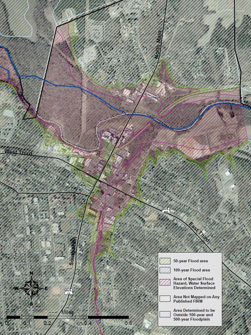
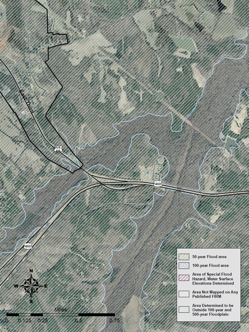
12 Town of Zone Maps (maps created by CRC February Source - FEMA)

13
14
15
VULNERABILITY ASSESSMENT
 SOUTHSIDE HAMPTON ROADS HAZARD MITIGATION PLAN VULNERABILITY ASSESSMENT INTRODUCTION The Vulnerability Assessment section builds upon the information provided in the Hazard Identification and Analysis
COMMUNITY SUMMARY LINN COUNTY MULTI-JURISDICTIONAL HAZARD MITIGATION PLAN CITY OF LISBON
 COMMUNITY SUMMARY LINN COUNTY MULTI-JURISDICTIONAL HAZARD MITIGATION PLAN CITY OF LISBON This document provides a summary of the hazard mitigation planning information for the City of Lisbon that will
COMMUNITY SUMMARY LINN COUNTY MULTI-JURISDICTIONAL HAZARD MITIGATION PLAN CITY OF CENTRAL CITY
 COMMUNITY SUMMARY LINN COUNTY MULTI-JURISDICTIONAL HAZARD MITIGATION PLAN CITY OF CENTRAL CITY This document provides a summary of the hazard mitigation planning information for the City of Central City
Appendix F: Ozark special Road District Addendum
 Appendix F: Ozark special Road District Addendum F-1: Introduction and Planning Process F-1.1 Purpose The Christian County 2016 Multi-Jurisdictional Natural Hazards Mitigation Plan is an updated version
Key Fundamentals of Flood Insurance in the NFIP!
 a Welcome to Key Fundamentals of Flood Insurance in the NFIP! A Before and After approach for Housing Counselors Presented by: 1 Before the Flood Presenter Melanie Graham After the Flood Presenter Erin
MONROE COUNTY 2015 LMS STEP TWO: CHARACTERIZATION FORM
 MONROE COUNTY 2015 LMS STEP TWO: CHARACTERIZATION FORM This form is used to submit information necessary for the LMS Work Group to score and prioritize an initiative relative to other initiatives and projects.
APPENDIX D PLANNING PROCESS DOCUMENTATION
 APPENDIX D PLANNING PROCESS DOCUMENTATION This appendix includes the following: 1. Meeting Agendas 2. Meeting Minutes 3. Meeting Sign-In Sheets 4. Public Survey Summary Results 1) Introductions AGENDA
in coordination with Peoria County, Planning and Zoning Department
 Prepared by Amec Foster Wheeler Environment & Infrastructure Hazard Mitigation and Emergency Management Program in coordination with Peoria County, Planning and Zoning Department The purpose of hazard
Hazard Mitigation Planning
 Hazard Mitigation Planning Mitigation In order to develop an effective mitigation plan for your facility, residents and staff, one must understand several factors. The first factor is geography. Is your
HAZARD MITIGATION PLAN POINT OF CONTACT. MUNICIPAL PROFILE
 HAZARD MITIGATION PLAN POINT OF CONTACT washtwpemc@ptd.net MUNICIPAL PROFILE MUNICIPAL PARTICIPATION Compliance with the National Flood Insurance Program (NFIP) Topic 1. Staff Resources Is the Community
DeSoto Parish Hazard Mitigation Plan Update Kick-off Meeting. February 16, 2016 Grand Cane, LA
 DeSoto Parish Hazard Mitigation Plan Update Kick-off Meeting February 16, 2016 Grand Cane, LA Introductions Officials Mitigation Steering Committee members SDMI team members GOHSEP hazard mitigation team
CITY OF PLANTATION ENGINEERING DEPARTMENT INTEROFFICE MEMORANDUM NO
 CITY OF PLANTATION ENGINEERING DEPARTMENT INTEROFFICE MEMORANDUM NO. 2013-003 DATE: October 22, 2012 TO: Mayor and Members of City Council FROM: Brett W. Butler, PE, CFM City Engineer SUBJECT: CRS Program
Hillsborough County Local Mitigation Strategy and the Community Rating System
 Hillsborough County Local Mitigation Strategy and the Community Rating System Presented By Hillsborough County s Hazard Mitigation Section Eugene Henry, Manager Hazard Mitigation Contributing Team Members:
Village of Blue Mounds Annex
 Village of Blue Mounds Annex Community Profile The Village of Blue Mounds is located in the southwest quadrant of the County, north of the town of Perry, west of the town of Springdale, and south of the
Town of Montrose Annex
 Town of Montrose Annex Community Profile The Town of Montrose is located in the Southwest quadrant of the County, east of the Town of Primrose, south of the Town of Verona, and west of the Town of Oregon.
SOUTH CENTRAL REGION MULTI-JURISDICTION HAZARD MITIGATION PLAN. Advisory Committee Meeting September 12, 2012
 SOUTH CENTRAL REGION MULTI-JURISDICTION HAZARD MITIGATION PLAN Advisory Committee Meeting September 12, 2012 AGENDA FOR TODAY Purpose of Meeting Engage All Advisory Committee Members Distribute Project
Q1 Do you...(check all that apply).
.") Q1 Do you...(check all that apply). Live in the City of... Work in the City of... Visit the City of Hesperia... Live in the City of Hesperia Work in the City of Hesperia Visit the City of Hesperia but
Q1 Do you...(check all that apply). Live in the City of... Work in the City of... Visit the City of Hesperia... Live in the City of Hesperia Work in the City of Hesperia Visit the City of Hesperia but
HAZARD MITIGATION PLAN POINT OF CONTACT MUNICIPAL PROFILE
 HAZARD MITIGATION PLAN POINT OF CONTACT northcatasauquaema@yahoo.com scheirerg@gmail.com MUNICIPAL PROFILE MUNICIPAL PARTICIPATION Compliance with the National Flood Insurance Program (NFIP) Identify source
Sussex County All Hazard Mitigation Plan. Plan Executive Summary
 Sussex County All Hazard Mitigation Plan Plan Executive Summary March 2010 SUSSEX COUNTY ALL HAZARD MITIGATION PLAN SUMMARY March 2010 For questions and to make comments on this document, contact: Joseph
9.10 HEIDELBERG TOWNSHIP
 9.10 HEIDELBERG TOWNSHIP This section presents the jurisdictional annex for Heidelberg Township. A. HAZARD MITIGATION PLAN POINT OF CONTACT Name Title/ Department Address Telephone Fax Email Primary Point
Natural Hazards Risks in Kentucky. KAMM Regional Training
 Natural Hazards Risks in Kentucky KAMM Regional Training Floodplain 101 Kentucky has approximately 92,000 linear miles of streams and rivers Approximately 31,000 linear miles have mapped flood hazards
OPTIONAL HAZARD MITIGATION ACTIONS FOR CONSIDERATION
 OPTIONAL HAZARD MITIGATION ACTIONS FOR CONSIDERATION Hazard Identify sites where stream and rain gages need to be added or upgraded and coordinate installation requests Implement or expand rainfall observer
Multi-Jurisdictional Hazard Mitigation Plan. Data Collection Questionnaire. For Local Governments
 Multi-Jurisdictional Hazard Mitigation Plan Data Collection Questionnaire County: For Local Governments Jurisdiction: Return to: Marcus Norden, Regional Planner BRP&EC Please complete this data collection
Garfield County NHMP:
 Garfield County NHMP: Introduction and Summary Hazard Identification and Risk Assessment DRAFT AUG2010 Risk assessments provide information about the geographic areas where the hazards may occur, the value
2015 Mobile County, Alabama Multi-Hazard Mitigation Plan Appendices
 2015 Mobile County, Alabama Multi-Hazard Mitigation Plan A - Federal Requirements for local Mitigation Plans B - Community Mitigation Capabilities C - 2009 Plan Implementation Status D - Hazard Ratings
Dade County Natural Hazard Mitigation Plan
 Introduction to Mitigation Definition of Mitigation Mitigation is defined by FEMA as "...sustained action that reduces or eliminates longterm risk to people and property from natural hazards and their
9.35 VILLAGE OF TULLY
 9.35 VILLAGE OF TULLY This section presents the jurisdictional annex for the Village of Tully. A.) HAZARD MITIGATION PLAN POINT OF CONTACT Primary Point of Contact Elizabeth L. Greenwood, Mayor 5833 Meetinghouse
Natural Hazards Mitigation Plan. Executive Summary
 Natural Hazards Mitigation Plan Executive Summary 1. Introduction Kane County Illinois, is subject to natural hazards that threaten life and health and have caused extensive property damage. Floods struck
Natural Hazards Mitigation Plan Kankakee County, Illinois Executive Summary
 1. Introduction Natural Hazards Mitigation Plan Kankakee County, Illinois Executive Summary Kankakee County is subject to natural hazards that threaten life, safety, health, and welfare and cause extensive
SECTION 1 INTRODUCTION
 SECTION 1 INTRODUCTION This section provides a general introduction to the Mississippi Emergency Management Agency (MEMA) District 9 Regional Hazard Mitigation Plan. It consists of the following five subsections:
9.2 ALBURTIS BOROUGH. This section presents the jurisdictional annex for Alburtis Borough. A. HAZARD MITIGATION PLAN POINT OF CONTACT
 9.2 ALBURTIS BOROUGH This section presents the jurisdictional annex for Alburtis Borough. A. HAZARD MITIGATION PLAN POINT OF CONTACT Name Title/ Department Address Telephone Fax Email Primary Point of
1 Rare Hazard event is not likely to occur within 100 years. 2 Occasional Hazard event is likely to occur within 100 years
 5.3 HAZARD RANKING After the hazards of concern were identified for Onondaga County, the hazards were ranked to describe their probability of occurrence and their impact on population, property (general
Federal Flood Insurance Changes (National Flood Insurance Program NFIP)
") Federal Flood Insurance Changes (National Flood Insurance Program NFIP) Biggert-Waters (BW-12) Flood Insurance Reform Act 2012 HR 4348 Signed by the President on July 6, 2012 Public Works, Engineering
Federal Flood Insurance Changes (National Flood Insurance Program NFIP) Biggert-Waters (BW-12) Flood Insurance Reform Act 2012 HR 4348 Signed by the President on July 6, 2012 Public Works, Engineering
Southwest Florida Healthcare Coalition
 Southwest Florida Healthcare Coalition Hazards Vulnerability Assessment 2018 1 Table of Contents Summary 3 EmPower Maps and Data 5 Social Vulnerability Index Maps 19 Suncoast Disaster Healthcare Coalition
9.8 FOUNTAIN HILL BOROUGH
 9.8 FOUNTAIN HILL BOROUGH This section presents the jurisdictional annex for Fountain Hill Borough. A. HAZARD MITIGATION PLAN POINT OF CONTACT Name Title/ Department Address Telephone Fax Email Primary
Hazard Mitigation Overview
 Hazard Mitigation Overview Yahara Lakes Advisory Group April 28, 2011 1 Discussion Topics Recent flood losses and damages Hazard mitigation programs Project opportunities 2 Recent Flood Losses* Date May
HAZARD MITIGATION PLAN POINT OF CONTACT MUNICIPAL PROFILE
 HAZARD MITIGATION PLAN POINT OF CONTACT nazareth50em1@gmail.com jessicagteel@gmail.com MUNICIPAL PROFILE MUNICIPAL PARTICIPATION 3. Describe how the public will be engaged in the current planning process
LOCAL HAZARD MITIGATION PLAN REVIEW FEMA REGION VI AND STATE OF TEXAS
 LOCAL HAZARD MITIGATION FEMA REGION VI AND STATE OF TEXAS Instructions for using the attached Crosswalk Reference Document for Review and Submission of Local Mitigation Action Plans to the State Hazard
HAZARD MITIGATION PLAN POINT OF CONTACT MUNICIPAL PROFILE
 HAZARD MITIGATION PLAN POINT OF CONTACT louise@windgap-pa.gov jeffreyyob@gmail.com MUNICIPAL PROFILE MUNICIPAL PARTICIPATION Compliance with the National Flood Insurance Program (NFIP) Identify source
Pinellas County Local Mitigation Strategy Progress Report
 Date: April 22, 2018 To: From: Subject: City of Commissioners Joseph A. DiPasqua, CBO, CFM, Assistant Director of Planning & Development Progress Report Background, Florida, and its 23 incorporated municipalities
9.36 TOWN OF VAN BUREN
 9.36 TOWN OF VAN BUREN This section presents the jurisdictional annex for the Town of Van Buren. A.) HAZARD MITIGATION PLAN POINT OF CONTACT Primary Point of Contact David J. Pringle, Code Enforcement
Role of Disaster Insurance in Improving Resilience: An Expert Meeting The Resilient America Roundtable
 Role of Disaster Insurance in Improving Resilience: An Expert Meeting The Resilient America Roundtable National Academy of Science Washington, DC July 9, 2015 Roseville Demographics Primary population
HAZARD MITIGATION PLAN POINT OF CONTACT MUNICIPAL PROFILE
 HAZARD MITIGATION PLAN POINT OF CONTACT hankvb@entermail.net khorvath@kceinc.com MUNICIPAL PROFILE MUNICIPAL PARTICIPATION Compliance with the National Flood Insurance Program (NFIP) Topic 1. Staff Resources
9.12 VILLAGE OF FABIUS
 9.12 VILLAGE OF FABIUS This section presents the jurisdictional annex for the Village of Fabius. A.) HAZARD MITIGATION PLAN POINT OF CONTACT Primary Point of Contact Melanie Vilardi, Town Supervisor P.O.
CHAPTER THREE Natural Hazard Mitigation Strategy
 CHAPTER THREE Natural Hazard Mitigation Strategy Chapter 3 Section All Sections Updates to Section Revised Natural Hazards Introduction and all Sections to change Natural Hazards Subcommittee to Committee.
VULNERABILITY ASSESSMENT
 SOUTHSIDE HAMPTON ROADS HAZARD MITIGATION PLAN VULNERABILITY ASSESSMENT 2011 UPDATE Each of the hazards in this section was reviewed and updated to reflect the revised information obtained for the updated
ANNEX B: TOWN OF BLUE RIVER
 ANNEX B: TOWN OF BLUE RIVER B.1 Community Profile Figure B.1 shows a map of the Town of Blue River and its location within Summit County. Figure B.1. Map of Blue River Summit County (Blue River) Annex
G318 Local Mitigation Planning Workshop. Module 2: Risk Assessment. Visual 2.0
 G318 Local Mitigation Planning Workshop Module 2: Risk Assessment Visual 2.0 Unit 1 Risk Assessment Visual 2.1 Risk Assessment Process that collects information and assigns values to risks to: Identify
9.46 NAZARETH BOROUGH
 9.46 NAZARETH BOROUGH This section presents the jurisdictional annex for Nazareth Borough. A. HAZARD MITIGATION PLAN POINT OF CONTACT Name Title/ Department Address Telephone Fax Email Primary Point of
Simsbury. Challenges Capitol Region Natural Hazards Mitigation Plan Update - Page 356
 Simsbury Simsbury is a suburban community of about 23,600 located in the western portion of the Capitol Region. Its land area encompasses 33.9 square miles. Elevation in town generally ranges from about
A.) HAZARD MITIGATION PLAN POINT OF CONTACT
 HAZARD MITIGATION PLAN POINT OF CONTACT") 9.6 TOWN OF CLAY This section presents the jurisdictional annex for the Town of Clay. A.) HAZARD MITIGATION PLAN POINT OF CONTACT Primary Point of Contact Mark Territo, Commissioner of Planning & Development
9.6 TOWN OF CLAY This section presents the jurisdictional annex for the Town of Clay. A.) HAZARD MITIGATION PLAN POINT OF CONTACT Primary Point of Contact Mark Territo, Commissioner of Planning & Development
Northern Kentucky University 2018 Hazard Mitigation Plan. Public Kick-Off Meeting March 20, 2018
 Northern Kentucky University 2018 Hazard Mitigation Plan Public Kick-Off Meeting March 20, 2018 Agenda Welcome Hazard Mitigation Planning 101 Hazard Identification Exercises Next Steps Jeff Baker, NKU
9.24 WEISENBERG TOWNSHIP
 9.24 WEISENBERG TOWNSHIP This section presents the jurisdictional annex for Weisenberg Township. A. HAZARD MITIGATION PLAN POINT OF CONTACT Name Title/ Department Address Telephone Fax Email Primary Point
Local Hazard Mitigation Plan Review. FEMA Region VI and the State of Texas
 Appendix E: Local Hazard Mitigation Plan Review For FEMA Region VI and the State of Texas LOCAL HAZARD MITIGATION PLAN REVIEW FOR PAGE 1 FEMA REGION 6 AND STATE OF TEXAS FOR FEMA USE ONLY Instructions
9.15 MACUNGIE BOROUGH
 9.15 MACUNGIE BOROUGH This section presents the jurisdictional annex for Macungie Borough. A. HAZARD MITIGATION PLAN POINT OF CONTACT Name Title/ Department Address Telephone Fax Email Primary Point of
SUMMARY NOTES OF THE FEBRUARY 13, 2018 MEETING OF THE OZAUKEE COUNTY HAZARD MITIGATION PLAN LOCAL PLANNING TEAM
 SUMMARY NOTES OF THE FEBRUARY 13, 2018 MEETING OF THE OZAUKEE COUNTY HAZARD MITIGATION PLAN LOCAL PLANNING TEAM INTRODUCTION The February 13, 2018 meeting of the Ozaukee County Hazard Mitigation Plan Local
HAZARD MITIGATION PLAN POINT OF CONTACT. MUNICIPAL PROFILE
 HAZARD MITIGATION PLAN POINT OF CONTACT troseberry@easton-pa.gov cmanges@easton-pa.gov MUNICIPAL PROFILE MUNICIPAL PARTICIPATION Compliance with the National Flood Insurance Program (NFIP) Identify source
9.4 VILLAGE OF CAMILLUS
 9.4 VILLAGE OF CAMILLUS This section presents the jurisdictional annex for the Village of Camillus. A.) HAZARD MITIGATION PLAN POINT OF CONTACT Primary Point of Contact Kurt Brunger, Mayor 37 Main Street,
HAZARD MITIGATION PLAN POINT OF CONTACT MUNICIPAL PROFILE
 HAZARD MITIGATION PLAN POINT OF CONTACT tatamy1@rcn.com dwerkheiser@tatamypa.com MUNICIPAL PROFILE MUNICIPAL PARTICIPATION Topic Identify source of information, if different from the one listed Additional
HAZARD MITIGATION PLAN POINT OF CONTACT MUNICIPAL PROFILE
 HAZARD MITIGATION PLAN POINT OF CONTACT jmeyers75@ptd.net joshbingham@lehighcounty.org MUNICIPAL PROFILE MUNICIPAL PARTICIPATION Compliance with the National Flood Insurance Program (NFIP) Topic 1. Staff
Planning Process Documentation
 Appendix D Planning Process Documentation This appendix includes: 1. Meeting Agendas 2. Meeting Minutes 3. Meeting Sign-In Sheets AGENDA Wake County Multi-Jurisdictional Hazard Mitigation Plan West Wake
Matthew W. Wall Recovery and Resilience Division Acting Director Virginia Department of Emergency Management
 Matthew W. Wall Recovery and Resilience Division Acting Director Virginia Department of Emergency Management Matthew.wall@vdem.virginia.gov 1 Hazard mitigation is any sustained action taken to reduce or
Stoddard County Natural Hazard Mitigation Plan-Five Year Update SECTION 3
 SECTION 3 CITY/COUNTY CAPABILITY ASSESSMENT Mitigation Management Policies This section is an update from the approved Stoddard County 2004 Plan. Specific updates include new information on population
According to the U.S. Census, the 2010 population for the Town was 4,024.
 9.8 Town of Greene This section presents the jurisdictional annex for the Town of Greene. 9.8.1 Hazard Mitigation Plan Point of Contact The following individuals have been identified as the hazard mitigation
JUNEAU COUNTY ALL HAZARDS MITIGATION PLAN UPDATE. OVERSIGHT COMMITTEE KICK-OFF September 21, 2016
 JUNEAU COUNTY ALL HAZARDS MITIGATION PLAN UPDATE OVERSIGHT COMMITTEE KICK-OFF September 21, 2016 DARRYL L. LANDEAU, AICP SENIOR PLANNER NORTH CENTRAL WI REGIONAL PLANNING COMMISSION Past Work of NCWRPC
According to the U.S. Census, the 2010 population for the Town was 803.
 9.18 Town of Pitcher This section presents the jurisdictional annex for the Town of Pitcher. 9.18.1 Hazard Mitigation Plan Point of Contact The following individuals have been identified as the hazard
School District Mitigation Planning 101 April 28 th 30 th 2014
 School District Mitigation Planning 101 April 28 th 30 th 2014 Kenneth A. Goettel Goettel & Associates Inc. 1732 Arena Drive Davis, CA 95618 (530) 750-0440 KenGoettel@aol.com What is Hazard Mitigation?
Name Title/ Department Address Telephone Fax
 9.14 LYNN TOWNSHIP This section presents the jurisdictional annex for Lynn Township. A. HAZARD MITIGATION PLAN POINT OF CONTACT Name Title Address Telephone Fax Email Primary Point of Contact Janet Henritzy
East Hartford. Challenges
 East Hartford The Town of East Hartford is a suburban community of approximately 52,212 located east of the City of Hartford and west of the Town of Manchester. The Town covers slightly more than 18 square
9.36 HANOVER TOWNSHIP
 9.36 HANOVER TOWNSHIP This section presents the jurisdictional annex for Hanover Township. A. HAZARD MITIGATION PLAN POINT OF CONTACT Name Title/ Department Address Telephone Fax Email Primary Point of
BACKGROUND ANNUAL PROGRESS REPORT DEVELOPMENT ADOPTION OF THE H-GAC HAZARD MITIGATION PLAN/UPDATES MISSION STATEMENT
 BACKGROUND CITY OF CONROE FLOODPLAIN MANAGEMENT ANNUAL PROGRESS Activity 510 of the National Flood Insurance Program s (NFIP) Community Rating System (CRS) requires the development of a Floodplain Management
Flood Vulnerability Assessment for Critical Facilities. Molly Woloszyn Lisa Graff, GISP, CFM
 Flood Vulnerability Assessment for Critical Facilities Molly Woloszyn Lisa Graff, GISP, CFM 2011 University of Illinois Board of Trustees. All rights reserved. For permission information, contact the Illinois
Flood Risk Outreach Tools for Georgia Communities. GAFM 10 th Annual Conference Presented By: Jarrett Mattli
 Flood Risk Outreach Tools for Georgia Communities GAFM 10 th Annual Conference Presented By: Jarrett Mattli April 13, 2016 Presentation Overview Guidebooks Toolkits Templates Educational Videos Resource
49.23 North Plainfield Board of Education
 49.23 North Plainfield Board of Education This section presents the jurisdictional annex for the North Plainfield Board of Education (NPBOE). 9.23.1 HAZARD MITIGATION PLAN POINTS OF CONTACT Primary Point
FEMA s Non-Disaster Grant Programs
 FEMA s Non-Disaster Grant Programs KAMM Conference August 24, 2016 UK Hazard Mitigation Grants Program 1 Non-Disaster Grant Programs Pre-Disaster Mitigation (PDM) Flood Mitigation Assistance (FMA) 2 Non-Disaster
CHAPTER 20. WHITMAN COUNTY FIRE DISTRICT #2 ANNEX
 CHAPTER 20. WHITMAN COUNTY FIRE DISTRICT #2 ANNEX 20.1 HAZARD MITIGATION PLAN POINT OF CONTACT Gaylon Hergert, President P.O. Box 221 St. John, Washington 99171-0221 Phone: (509) 648-4015 Cell #: (509)
HAZARD MITIGATION PLAN POINT OF CONTACT MUNICIPAL PROFILE
 HAZARD MITIGATION PLAN POINT OF CONTACT susanlmbt@frontier.com jcoyle@carrollengineering.com MUNICIPAL PROFILE MUNICIPAL PARTICIPATION Compliance with the National Flood Insurance Program (NFIP) Identify
Winter Storm Jonas Hazard Mitigation Grant Program
 Winter Storm Jonas Hazard Mitigation Grant Program Avalon, Ocean City, Sea Isle City and Stone Harbor March 25, 2017 Sea Isle City April 1, 2017 Ocean City Today's Agenda Nor Easter Jonas Hazard Mitigation
Volusia County Floodplain Management Plan 2012
 Volusia County Floodplain Management Plan 2012 Introduction The National Flood Insurance Program (NFIP) provides federally supported flood insurance in communities that regulate development in floodplains.
9.17 Town of Pharsalia
 9.17 Town of Pharsalia This section presents the jurisdictional annex for the Town of Pharsalia. 9.17.1 Hazard Mitigation Plan Point of Contact The following individuals have been identified as the hazard
9.11 BETHLEHEM TOWNSHIP
 9.11 BETHLEHEM TOWNSHIP This section presents the jurisdictional annex for Bethlehem. A. HAZARD MITIGATION PLAN POINT OF CONTACT Name Title/ Department Address Telephone Fax Email Primary Point of Contact
Truckloads (at 25 tons/truck) of building debris 90
 of building debris 90") Marlborough Marlborough is a rural community in Hartford County covering a land area of 23.3 square miles and with an estimated population of 6,410. Elevation ranges from about 160 to 800 feet. The Town
Marlborough Marlborough is a rural community in Hartford County covering a land area of 23.3 square miles and with an estimated population of 6,410. Elevation ranges from about 160 to 800 feet. The Town
9.3 VILLAGE OF DOBBS FERRY
 9.3 VILLAGE OF DOBBS FERRY This section presents the jurisdictional annex for the Village of Dobbs Ferry. A.) HAZARD MITIGATION PLAN POINT OF CONTACT Primary Point of Contact Marcus Serrano, Village Administrator
9.15 VILLAGE OF JORDAN
 9.15 VILLAGE OF JORDAN This section presents the jurisdictional annex for the Village of Jordan. A.) HAZARD MITIGATION PLAN POINT OF CONTACT Primary Point of Contact Fred DiRisio, Superintendent of Public
APPENDIX 1 FEMA MITIGATION GRANT PROGRAMS
 APPENDIX 1 FEMA MITIGATION GRANT PROGRAMS 2016 FEMA FUNDING POSSIBILITIES FOR SCHOOL DISTRICTS IN WASHINGTON Overview For public entities in Washington, including school districts, FEMA mitigation funding
10/5/2015. What Makes a Sound Floodplain Management Program? What are the Flood Problems in your Community?
 The Community Rating System (CRS) and Hazard Mitigation Planning Preparing Your Community Through Common Program Goals September 3, 2015 What Makes a Sound Floodplain Management Program? Know your community
HAZARD MITIGATION PLAN POINT OF CONTACT MUNICIPAL PROFILE
 HAZARD MITIGATION PLAN POINT OF CONTACT glendonboro@rcn.com glendonboro@rcn.com MUNICIPAL PROFILE MUNICIPAL PARTICIPATION Identify source of information, if different Topic from the one listed 1. Staff
9.3 TOWN OF CAMILLUS. This section presents the jurisdictional annex for the Town of Camillus. HAZARD MITIGATION PLAN POINT OF CONTACT TOWN PROFILE
 9.3 TOWN OF CAMILLUS This section presents the jurisdictional annex for the Town of Camillus. A.) HAZARD MITIGATION PLAN POINT OF CONTACT Primary Point of Contact Mark Pigula, Highway Superintendent 4600
HAZARD MITIGATION PLAN POINT OF CONTACT MUNICIPAL PROFILE
 HAZARD MITIGATION PLAN POINT OF CONTACT assistmanager@lowermilford.net publicworks@lowermilford.org MUNICIPAL PROFILE MUNICIPAL PARTICIPATION Compliance with the National Flood Insurance Program (NFIP)
9.48 NORTHAMPTON BOROUGH
 9.48 NORTHAMPTON BOROUGH This section presents the jurisdictional annex for Northampton Borough. A. HAZARD MITIGATION PLAN POINT OF CONTACT Name Title/ Department Address Telephone Fax Email Primary Point
T-318. Hazard Mitigation Section TDEM Recovery, Mitigation, and Standards
 T-318 Local Hazard Mitigation Plan Requirements Hazard Mitigation Section TDEM Recovery, Mitigation, and Standards Raymond Mejia, Lead Hazard Mitigation Planner Samantha Aburto, Hazard Mitigation Planner
Plan Maintenance Procedures
 PLAN MAINTENANCE PLAN MAINTENANCE PROCEDURES... 1 MONITORING AND EVALUATION... 2 PLAN MONITORING... 2 PLAN EVALUATION... 2 UPDATING... 2 PLAN AMENDMENTS... 2 FIVE (5) YEAR REVIEW... 3 INCORPORATION...
Town of Pleasant Springs Annex
 Town of Pleasant Springs Annex Community Profile The Town of Pleasant Springs is located in the southeast quadrant of Dane County, west of the Town of Christiana, north of the town of Dunkirk, and east
PHASE 2 HAZARD IDENTIFICATION AND RISK ASSESSMENT
 Prioritize Hazards PHASE 2 HAZARD IDENTIFICATION AND After you have developed a full list of potential hazards affecting your campus, prioritize them based on their likelihood of occurrence. This step
Challenges. Estimated Damages from 100-Year Flood
 Newington Newington is a fully suburban town in central Connecticut with a population of about 30,562. The Town encompasses 13.2 square miles and ranges in elevation from 40-350 feet above sea level. The
Avon. Challenges. Estimated Damages from 100- Year Flood
 Avon Avon is a suburban town in north-central Connecticut with a population of about 18,000. It has an average elevation of about 350 ft. The Town encompasses 23.5 square miles, lying entirely within the
Multi-Hazard Risk Management Project The Smithsonian Institution (SI)
") Multi-Hazard Risk Management Project The Smithsonian Institution (SI) Over 700 facilities worldwide dedicated to research, exhibit, and outreach 18 museums and galleries in Washington DC and NYC wide variety
Multi-Hazard Risk Management Project The Smithsonian Institution (SI) Over 700 facilities worldwide dedicated to research, exhibit, and outreach 18 museums and galleries in Washington DC and NYC wide variety
9.2 VILLAGE OF ARDSLEY
 9.2 VILLAGE OF ARDSLEY This section presents the jurisdictional annex for the Village of Ardsley. A.) HAZARD MITIGATION PLAN POINT OF CONTACT Primary Point of Contact Larry J. Tomasso, Building Inspector,
Interagency Nonstructural Flood Risk Management Workshop. Carey Johnson Kentucky Division of Water
 Interagency Nonstructural Flood Risk Management Workshop Carey Johnson Kentucky Division of Water Nonstructural Flood Risk Management Nonstructural floodproofing Elevation Relocation Buyout/acquisition
Emergency Preparedness and Protection of Field Equipment. DPLE 280 September 7, 2016
 Emergency Preparedness and Protection of Field Equipment DPLE 280 September 7, 2016 RLI Design Professionals is a Registered Provider with The American Institute of Architects Continuing Education Systems.