Floodplain Management Legal Issues. Making the Case for a No Adverse Impact Approach
|
|
|
- Eileen Washington
- 5 years ago
- Views:
Transcription
1 Floodplain Management Legal Issues Making the Case for a No Adverse Impact Approach

2 The Association of State Floodplain Managers 2 ASFPM began more than 45 years ago as a grassroots organization of floodplain managers in the Midwest and now includes more than 16,000 members worldwide. Our mission has always been to: help develop and implement national flood policy and programs that reduce damages, human suffering and taxpayer costs of flooding; mitigate the losses, costs, and human suffering caused by flooding; protect the natural and beneficial functions of floodplains.

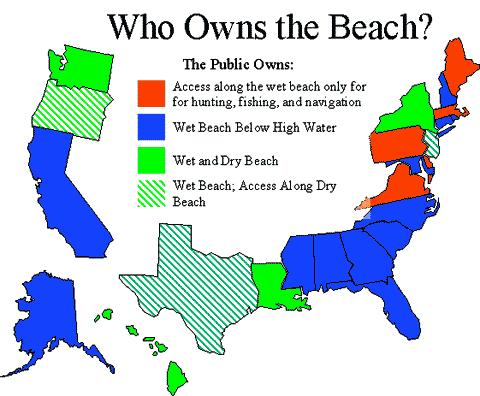
3 Public Trust Doctrine By the law of nature these things are common to all mankind, the air, running water, the sea and consequently the shores of the sea The seashore extends as far as the greatest winter flood runs up. - Institutes of Justinian 535 CE

4 Public Trust Doctrine Colonies followed English common law Recognized public rights in navigable waters & their shores Public uses Access for commerce and transportation Environmental protection Recreation
 State had abdicated its responsibility to")
5 Illinois Central Illinois Central RR v. Illinois (1892) State had abdicated its responsibility to preserve the waters for public use
6 Navigable Waters Federal definition: capable of interstate commerce State definitions: all tidewaters, regardless of actual navigability navigable freshwaters and the lands beneath Adjacent wetlands (varies greatly among States)
7

8 Legal Origins US Constitution States retain ownership of the lands beneath navigable waters Federal government retains supreme, but not exclusive, control over navigation
9 Federal, State and Local Roles The Constitution of the United States of America Amendment X (1791): The powers not delegated to the United States by the Constitution, nor prohibited by it to the States, are reserved to the States Respectively, or to the people
10 Property Rights Each stick represents a right or stream of benefits Individual rights to: Sell Lease Mortgage Subdivide Grant easement Public rights to: Tax Take for public use Control use of Dispose of in case of death 3-21
11 Landowner Does Not Have All Rights under the Law There is no right to: Be a nuisance; Violate the property rights of others; Trespass; Be negligent; Violate laws of reasonable surface water use or riparian laws; or Violate public trust. 3-24
12 Police Powers Procedural Due Process: Government decision-making must: 1. Be unbiased; 2. Include notice and hearing; 3. Allow for cross-examination; 4. Be based on record; and 5. Involve no undue influence. Substantive Due Process: All laws, rules, and regulations must: 1. Advance a legitimate public purpose; and 2. Be rationally related to the government objective. 3-19
13 Three U.S. Supreme Court Cases Village of Euclid v. Ambler Realty (1926): 10th Amendment to the U.S. Constitution Nectow v. City of Cambridge (1928): 14th Amendment to the U.S. Constitution Kelo v. City of New London (2005): 5th Amendment to the U.S. Constitution (Eminent Domain) 3-17
14 Police Powers Takings: Regulations that go too far Public Purpose Test Relationship Test Economic Impact 3-20
15 What Constitutes a Taking? Physical occupation of private land Regulation that goes too far Permit condition lacks a rational connection or essential nexus with a valid public purpose No rough proportionality between permit condition and impact of development Total deprivation of economic use Interference with reasonable investment backed expectations Compensable taking may occur even when restriction is temporary 15
16 Government May be Held Liable if: Construction of a road blocks drainage; Stormwater system increases flows; Structure blocks watercourse; Bridge is built without adequate opening; Grading land increases runoff; Flood control structure causes damage; Filling wetland causes damage; or Permits issued for development cause harm to a third party. 3-25
17 Legal Research Findings Most successful suits against communities result from actions such as inadequate construction or inadequate maintenance of dams, levees, roads, and bridges which increase flood damages on other lands. Act of God defense is less and less defensible. Even rare floods are predictable. As are residual risks from levees and dams. If a community permits development that results in an adverse impact, your community may be liable, even if you meet code standards. 17
18 Legal Research Findings No cases found where a landowner prevailed in a regulatory takings suit against a community s denial of use, where the proposed use would have had any substantial offsite impacts or threatened public safety. Courts have broadly supported restrictive regulations for high risk flood areas based upon public safety, nuisance prevention, public trust and other concerns. 18
19 Beverly Bank v. Illinois Department of Transportation Illinois Supreme Court upheld state regulation prohibiting residential structures in 100-year floodway State argument focused on protecting health and welfare including Risk to first responders Risk to property owners who would be stranded Increased expenditure of public funds 19
20 Gove v. Chatham Zoning Board of Appeals (2005) Mass. Supreme Judicial Court upheld Town of Chatham s restrictive zoning standards that required a variance to build a house. The Court said: It is undisputed that [the parcel at issue] falls within a floodplain, and that its potential flooding would adversely affect the surrounding areas if the property were developed. Reasonable government action mitigating such harm... typically does not require compensation. A special permit could have been obtained for other uses, including the construction of piers, boathouses and boat shelters Testimony of first responders and adverse impacts to them was important 20
21 Avoiding a Taking Clearly Relate Regulation to Preventing Harm. (Gove) Avoid interfering with owner s right to exclude. (Loretto) Avoid denial of all economic uses. (Lucas) Consider Transferable Development Rights or similar residual rights and uses to retain economic value. (Penn Central) Demonstrate relationship between permit condition and harm avoided. (Koontz) 21
22 Upland Land Use Management National Government No Jurisdiction - Incentives State Government Authority Remains with States Local Government Authority and/or requirements come from the State
23 Congressional Incentives Clean Water Act navigable waters Coastal Zone Management Act coastal zone Coastal Barrier Resources Act mapped areas National Flood Insurance Act nation-wide

24 What about the NFIP? 24
25 What about the NFIP? Under the minimum NFIP standards, properly permitted development allows: Floodwaters to be diverted onto other properties Channel and conveyance areas to be reduced Valley storage to be filled Changes in water velocities 25
26 U.S. Flood-Related Statistics Over 5.6 million flood insurance policies are in effect. Over $1.2 trillion in insurance coverage. Flood losses reached $10 billion annually by 2010; a 3-fold increase from early 1900s. Per capita damages increased by more than a factor of 2.5 in the previous century--in real dollar terms. 1910s 1920s 1930s 1940s 1950s 1960s 1970s 1980s 1990s 2000s Average Annual Flood Damages $2.2 $2.0 $2.9 $2.4 $3.4 $2.2 $4.9 $3.3 $5.6 $10.0 Billions (adjusted to 1999 dollars) 26
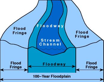
27 Floodway Assessment Addressing Cumulative Effects of Floodplain Encroachments 27
28 28
29 NFIP Regulations FEMA s regulations (Section 59.1) state: A floodway is defined as the channel of a river or other watercourse and the adjacent land areas that must be reserved in order to discharge the base flood without cumulatively increasing the water-surface elevation by more than a designated height.
30 NFIP Regulations CFR Title 44, Part 60, Section 60.3 No Floodway Defined 60.3 (c) (10) no new construction (including fill) permitted unless the cumulative effect... will not increase WSE more than one foot
31 NFIP Floodway Definition CFR Title 44, Part 60, Section 60.3 Designating Floodway 60.3 (d) (2) When provided with BFEs community shall select and adopt a regulatory floodway without increasing the water surface elevation (WSE) of that flood more than one foot.
32 Equal Degree of Encroachment Cumulative Impacts 32
33 Floodplain Description
. The conveyance function of floodplains is protected (e.g.")
 and other NFIP criteria indirectly promote the filling and channeling of the floodplain.")
34 NFIP Evaluation Findings Related to Natural and Beneficial Functions of Floodplains About 9,000 square miles of floodprone lands are delineated as floodways and protected from future development (2002). The conveyance function of floodplains is protected (e.g., the floodway), most others are not. The map revision process (e.g., LOMR-Fs) and other NFIP criteria indirectly promote the filling and channeling of the floodplain. The NFIP has not emphasized the protection of NBF and has few tools to help restore them, once they are impaired. 34

35 No Adverse Impact Defined/Explained NAI is a concept/policy/strategy that broadens one's focus from the built environment to include how changes to the built environment potentially impact other properties. NAI broadens property rights by protecting the property rights of those that would be adversely impacted by the actions of others. 3-23

36 No Adverse Impact Seven building blocks: 1. Hazard identification and floodplain mapping 2. Education and outreach 3. Planning 4. Regulations and development standards 5. Mitigation 6. Infrastructure 7. Emergency services 3-26
37 Key Points You are more likely to be successfully sued for permitting risky development than for preventing it. Take a No Adverse Impact approach to flooding issues to reduce liability and minimize takings claims. 37

38 Resources > publications and policy papers > legal papers Credit given to the Natural Hazards Observer and Rob Pudim for all illustrations in this presentation
Floodplain Management. Making the Case for a No Adverse Impact (NAI) Approach
 Approach") Floodplain Management Making the Case for a No Adverse Impact (NAI) Approach Options and Actions to Address Flood Insurance Affordability 2 Disclaimer This presentation is neither intended to be, nor may
Floodplain Management Making the Case for a No Adverse Impact (NAI) Approach Options and Actions to Address Flood Insurance Affordability 2 Disclaimer This presentation is neither intended to be, nor may
NO ADVERSE IMPACT: A Common Sense Approach to Flood Risk Management
 NO ADVERSE IMPACT: A Common Sense Approach to Flood Risk Management Disclaimer This presentation is neither intended to be, nor may it be taken as legal advice. For legal advice, consult with an attorney
FREQUENTLY ASKED QUESTION ABOUT FLOODPLAINS Michigan Department of Environmental Quality
 FREQUENTLY ASKED QUESTION ABOUT FLOODPLAINS Michigan Department of Environmental Quality WHAT IS A FLOOD? The National Flood Insurance Program defines a flood as a general and temporary condition of partial
Floodplain Management 101. Mississippi Emergency Management Agency Floodplain Management Bureau
 Floodplain Management 101 Mississippi Emergency Management Agency Floodplain Management Bureau Stafford Act The Stafford Disaster Relief and Emergency Assistance Act (Stafford Act) (Public Law 100-707)
Justification for Floodplain Regulatory Standards in Illinois
 Justification for Floodplain Regulatory Standards in Illinois Office of Water Resources Issue Paper April, 2015 Proactive Illinois floodplain and floodway regulatory standards have prevented billions of
The Legal Aspects of the National Flood Insurance Program. Larissa Womack Senior Attorney MEMA
 The Legal Aspects of the National Flood Insurance Program Larissa Womack Senior Attorney MEMA *MEMA s legal staff may not provide legal advice to other agencies, persons or entities. Please refer to your
Article 23-6 FLOODPLAIN DISTRICT
 AMENDING THE CODE OF THE CITY OF PITTSFIELD CHAPTER 23, ZONING ORDINANCE SECTION I That the Code of the City of Pittsfield, Chapter 23, Article 23-6 Floodplain District, shall be replaced with the following:
a) Ensure public safety through reducing the threats to life and personal injury.
 Ensure public safety through reducing the threats to life and personal injury.") SECTION VII: FLOODPLAIN DISTRICT 7-1 Statement Of Purpose The purposes of the Floodplain District are to: a) Ensure public safety through reducing the threats to life and personal injury. b) Eliminate
SECTION VII: FLOODPLAIN DISTRICT 7-1 Statement Of Purpose The purposes of the Floodplain District are to: a) Ensure public safety through reducing the threats to life and personal injury. b) Eliminate
TOWN OF KENT, CT PLANNING AND ZONING COMMISSION
 TOWN OF KENT, CT PLANNING AND ZONING COMMISSION FLOOD PLAIN MANAGEMENT REGULATIONS Whereas, Congress has determined that a National Flood Insurance Program would alleviate personal hardships and economic
THE FLOOD HAZARD AREA Valda Opara New Jersey Department of Environmental Protection June 8, 2012
 THE FLOOD HAZARD AREA Valda Opara New Jersey Department of Environmental Protection June 8, 2012 Individual Permits Building Requirements 0% Net-fill Standards JET SKIING DURING A FLOOD ESCAPING THE FLOOD
Floodplain Management Annual Conference Atlanta, Georgia April 2017
 Floodplain Management 2017 Annual Conference Atlanta, Georgia April 2017 Floodplain Mapping and Flood Zones Zone Deisgnations: Zone A: No base flood elevations have been determined it is an approximated
MANAGING FLOODS OF THE FUTURE: CONCEPTS, TOOLS & SUCCESS STORIES Iowa Post-Disaster Workshops November 12 & 13, 2008 Cedar Falls & Iowa City, Iowa
 MANAGING FLOODS OF THE FUTURE: CONCEPTS, TOOLS & SUCCESS STORIES Iowa Post-Disaster Workshops November 12 & 13, 2008 Cedar Falls & Iowa City, Iowa Sam Riley Medlock, CFM, JD ASFPM Policy & Partnerships
Community Rating System. National Flood Insurance Program
 National Flood Insurance Program Community Rating System A Local Official s Guide to Saving Lives Preventing Property Damage Reducing the Cost of Flood Insurance FEMA B-573 / May 2015 How the Community
Using GISWeb to Determine Your Property s Flood Zone
 Using GISWeb to Determine Your Property s Flood Zone 1. In a new browser window, go to http://www.co.santacruz.ca.us/departments/geographicinformationsystemsgis.aspx 2. Click on GISWeb - GIS Mapping Application
CHAPTER 4. REGULATIONS AND DEVELOPMENT STANDARDS
 CHAPTER 4. REGULATIONS AND DEVELOPMENT STANDARDS Regulations and development standards, which can be used by communities to reduce damage from natural hazards, work best when using an effective planning
National Flood Insurance Program (NFIP) for Real Estate Professionals
 for Real Estate Professionals") National Flood Insurance Program (NFIP) for Real Estate Professionals 1 Joshua Oyer, CFM Outreach Specialist NFIP State Coordinator s Office at the Texas Water Development Board 2 Outline Introduction
National Flood Insurance Program (NFIP) for Real Estate Professionals 1 Joshua Oyer, CFM Outreach Specialist NFIP State Coordinator s Office at the Texas Water Development Board 2 Outline Introduction
Chapter 6 - Floodplains
 Chapter 6 - Floodplains 6.1 Overview The goal of floodplain management is to reduce the potential risks to both existing and future developments, and infrastructure, in the 100-year floodplain. Over the
Appendix B. A Comparison of the Minimum NFIP Requirements and the CRS
 A Comparison of the Minimum s and the CRS The Community Rating System provides credits for exceeding the minimum requirements of the National Flood Insurance Program (NFIP). Many local officials are not
REGION X FLOOD DAMAGE PREVENTION ORDINANCE WASHINGTON MODEL (REVISED 5/13/2004)
") REGION X FLOOD DAMAGE PREVENTION ORDINANCE WASHINGTON MODEL (REVISED 5/13/2004) Close to 300 towns, cities, counties, and tribes within the State of Washington participate in the National Flood Insurance
REGION X FLOOD DAMAGE PREVENTION ORDINANCE WASHINGTON MODEL (REVISED 5/13/2004) Close to 300 towns, cities, counties, and tribes within the State of Washington participate in the National Flood Insurance
SKOKOMISH RESERVATION FLOOD DAMAGE PREVENTION ORDINANCE TABLE OF CONTENTS
 TABLE OF CONTENTS STATUTORY AUTHORIZATION, FINDINGS OF FACT, PURPOSE, AND OBJECTIVES 6.04.001 Statutory Authorization 6.04.002 Findings of Fact 6.04.003 Statement of Purpose 6.04.004 Methods of Reducing
Table 1: Federal, State and Local Government Rules applicable to LOMRs/CLOMRS submittal
 MnDNR LOMC Guide This document has been prepared by the Minnesota Department of Natural Resources floodplain staff and is intended to provide assistance with LOMR/CLOMR submittals. This information is
ASFPM Update and NFIP Reform. KAMM 10 th Anniversary Conference September 9, 2014
 ASFPM Update and NFIP Reform KAMM 10 th Anniversary Conference September 9, 2014 AND HE SAID Floods are 'acts of God,' but flood losses are largely acts of man. 1945 PhD Dissertation Human Adjustments
ASFPM Partnerships for Statewide Mitigation Actions. Alicia Williams GIS and HMP Section Manager, Amec Foster Wheeler June 2016
 ASFPM Partnerships for Statewide Mitigation Actions Alicia Williams GIS and HMP Section Manager, Amec Foster Wheeler June 2016 Summary The Concept Leveraging Existing Data and Partnerships to reduce risk
Chapter 5 Floodplain Management
 Chapter 5 Floodplain Management Contents 1.0 Introduction... 1 2.0 Floodplain Management and Regulation... 1 2.1 City Code... 1 2.2 Floodplain Management... 1 2.3 Level of Flood Protection... 2 2.3.1 Standard
HENRY COUNTY, OHIO SPECIAL PURPOSE FLOOD DAMAGE PREVENTION REGULATIONS TABLE OF CONTENTS
 HENRY COUNTY, OHIO SPECIAL PURPOSE FLOOD DAMAGE PREVENTION REGULATIONS TABLE OF CONTENTS TABLE OF CONTENTS... i-ii SECTION 1.0 STATUTORY AUTHORIZATION, FINDINGS OF FACT PURPOSE AND OBJECTIVES 1.1 STATUTORY
BUTTS COUNTY, GEORGIA AND INCORPORATED AREAS
 BUTTS COUNTY, GEORGIA AND INCORPORATED AREAS Butts County Community Name Community Number BUTTS COUNTY (UNICORPORATED AREAS) 130518 FLOVILLA, CITY OF 130283 JACKSON, CITY OF 130222 JENKINSBURG, TOWN OF
The National Flood Insurance Program and Flood Insurance Rate Map for San Francisco. Presentation at Treasure Island Community Meeting
 The National Flood Insurance Program and Flood Insurance Rate Map for San Francisco Presentation at Treasure Island Community Meeting October 17, 2007 1 National Flood Insurance Program (NFIP) Overview
SECTION 9: MAPS AND DATA
 SECTION 9: MAPS AND DATA Contents 9.1. NFIP Maps and Data... 9-2 9.1.1. Adopting and enforcing NFIP floodplain maps and data... 9-2 9.1.2. Adopting and enforcing more restrictive data... 9-2 9.1.3. Annexations...
CHAPTER 15: FLOODPLAIN OVERLAY DISTRICT "FP"
 CHAPTER 15: FLOODPLAIN OVERLAY DISTRICT "FP" SECTION 15.1 STATUTORY AUTHORIZATION The legislature of the State of Minnesota in Minnesota Statutes, Chapter 103F and Chapter 394 has delegated the responsibility
CRISP COUNTY, GEORGIA AND INCORPORATED AREAS
 CRISP COUNTY, GEORGIA AND INCORPORATED AREAS Community Name Community Number ARABI, CITY OF 130514 CORDELE, CITY OF 130214 CRISP COUNTY (UNINCORPORATED AREAS) 130504 Crisp County EFFECTIVE: SEPTEMBER 25,
Presentation Overview
 2006 Northwest Stream Restoration Design Symposium The National Evaluation of the One-Percent (100-Year) Flood Standard and Potential Implications on Stream Restoration Projects Kevin Coulton, P.E., CFM
CITIZEN POTAWATOMI NATION PUBLIC CONSERVATION AND ENVIROMENTAL PROTECTION ACT TITLE 35
 CITIZEN POTAWATOMI NATION PUBLIC CONSERVATION AND ENVIROMENTAL PROTECTION ACT TITLE 35 CHAPTER SECTION 1 ESTABLISHMENT OF THE DEPARTMENT OF ENVIRONMENTAL PROTECTION Establishment 101 Required Reporting
FLOODPLAIN FAQ s. Last Update: June 2017
 FLOODPLAIN FAQ s Last Update: June 2017 What does FEMA stand for? Federal Emergency Management Agency - the operation of FEMA is to lead America to prepare for, prevent, respond to, and recover from disasters.
INSTRUCTIONS FOR COMPLETING THE APPLICATION FORMS FOR CONDITIONAL LETTERS OF MAP REVISION AND LETTERS OF MAP REVISION
 INSTRUCTIONS FOR COMPLETING THE APPLICATION FORMS FOR CONDITIONAL LETTERS OF MAP REVISION AND LETTERS OF MAP REVISION GENERAL In 1968, the U.S. Congress passed the National Flood Insurance Act, which created
JAXGIS FEMA Flood Hazard Mapping -- Frequently Asked Questions
 Flood Hazard Zone Designations Summary Zones starting with the letter 'A' (for instance, Zone A, Zone AE, Zone AH, Zone AO) denote a Special Flood Hazard Area, which can also be thought of as the 100-year
National Flood Insurance Program Final Nationwide Programmatic Environmental Impact Statement
 Final Nationwide Programmatic Environmental Impact Statement EXECUTIVE SUMMARY Action Agency: Federal Emergency Management Agency Cooperating Agency: U.S. Environmental Protection Agency September 2017
Floodplain Development Permit Application
 Floodplain Development Permit Application **All construction will also require a building permit** This is an application packet for a Floodplain Development Permit. Certain sections are to be completed
Volusia County Floodplain Management Plan 2012
 Volusia County Floodplain Management Plan 2012 Introduction The National Flood Insurance Program (NFIP) provides federally supported flood insurance in communities that regulate development in floodplains.
Floodplain Development Permits A Technical Guidance Document
 Floodplain Development Permits A Technical Guidance Document To Prevent Loss of Life, Reduce Property Damage and to Protect and Enhance the Natural and Beneficial Functions of Floodplains Iredell County
North Carolina Department of Public Safety Emergency Management Risk Management
 North Carolina Department of Public Safety Emergency Management Risk Management Roy Cooper, Governor Erik A. Hooks, Secretary Michael A. Sprayberry, Director INSTRUCTIONS FOR COMPLETING THE NORTH CAROLINA
Wetzel County Floodplain Ordinance
 Wetzel County Floodplain Ordinance AUTHORITY AND PURPOSE: THE PROVISIONS OF THIS ORDINANCE HAVE BEEN PREPARED WITH THE INTENTION OF MEETING THE REQUIREMENTS OF SECTION 60.3 (D) OF THE NATIONAL FLOOD INSURANCE
FLOODPLAIN MANAGEMENT PROGRAM ASSESSMENT GUIDANCE MANUAL
 FLOODPLAIN MANAGEMENT PROGRAM ASSESSMENT GUIDANCE MANUAL Created by the TEXAS COLORADO RIVER FLOODPLAIN COALITION 2 nd Edition June 2002 TCRFC H 300 P.O. Box 220 Austin, TX 78767 tcrfc-info@tcrfc.org www.tcrfc.org
NFIP Overview Elevation Certificate Flood Insurance Rate Maps. By: Maureen O Shea, AICP, CFM State NFIP Coordinator
 NFIP Overview Elevation Certificate Flood Insurance Rate Maps By: Maureen O Shea, AICP, CFM State NFIP Coordinator Example of a flood failure Example of a flood failure Purposes of the NFIP Identify &
UPDATE ON DALLAS FLOODWAY
 UPDATE ON DALLAS FLOODWAY ENVIRONMENTAL IMPACT STATEMENT [ EIS ] Transportation and Trinity River Project Committee Rob Newman Director, Trinity River Corridor Project, Fort Worth District 28 April 2014
1. STATUTORY AUTHORIZATION, FINDINGS OF FACT, AND PURPOSES... 2
 ORDINANCE NO. 15-03 CAPE GIRARDEAU COUNTY FLOODPLAIN MANAGEMENT ORDINANCE ARTICLE # PAGE # 1. STATUTORY AUTHORIZATION, FINDINGS OF FACT, AND PURPOSES... 2 2. GENERAL PROVISIONS... 3 3. ADMINISTRATION...
DES MOINES CITY OF TWO RIVERS. Flooding Risk & Impact to Development
 DES MOINES CITY OF TWO RIVERS Flooding Risk & Impact to Development River System Des Moines Flood Protection Des Moines Flood Protection cont. Infrastructure Over 24 miles of levees 21stormwater pump stations
Modernization, FEMA is Recognizing the connection between damage reduction and
 EXECUTIVE SUMMARY Every year, devastating floods impact the Nation by taking lives and damaging homes, businesses, public infrastructure, and other property. This damage could be reduced significantly
Pre-Development Floodplain Application
 Pre-Development Floodplain Application The Department of Planning, at the recommendation of FEMA, is now requiring completion of a Pre- Development Floodplain Application for all properties in the regulated
Flood Insurance THE TOPIC OCTOBER 2012
 Flood Insurance THE TOPIC OCTOBER 2012 Because of frequent flooding of the Mississippi River during the 1960s and the rising cost of taxpayer funded disaster relief for flood victims, in 1968 Congress
Floodplain Development Permit Application
 Floodplain Development Permit Application City of Jonesboro, AR This is an application packet for a Floodplain Development Permit. Certain sections are to be completed by the Applicant, and certain sections
ASFPM Update. GAFM 10 th Annual Technical Conference March 24, 2016
 ASFPM Update GAFM 10 th Annual Technical Conference March 24, 2016 AND HE SAID Floods are 'acts of God,' but flood losses are largely acts of man. 1945 PhD Dissertation Human Adjustments to Flood by Gilbert
Chapter 415 FLOODPLAIN MANAGEMENT
 Chapter 415 FLOODPLAIN MANAGEMENT Editor's Note Ordinance no. A-7015 1, adopted December 27, 2000, enacted written administrative procedures for the floodplain management herein. Those written administrative
CHAPTER 8 FLOOD PREVENTION AND PROTECTION*
 CHAPTER 8 FLOOD PREVENTION AND PROTECTION* ---------- *Cross reference(s)--drainage commission, 2-111 et seq.; drainage districts created, 2-114; site drainage requirements for manufactured or mobile home
Dealing With Unnumbered A Zones in Maine Floodplain Management
 Dealing With Unnumbered A Zones in Maine Floodplain Management The following is a list of acceptable methods that the State Floodplain Management Coordinator and the Federal Emergency Management Agency
ORDINANCE NO A FLOOD DAMAGE PREVENTION ORDINANCE
 ORDINANCE NO. 692-14 A FLOOD DAMAGE PREVENTION ORDINANCE WHEREAS, for a community to participate in the National Flood Insurance Program NFIP, it must adopt and enforce floodplain management regulations
Floodplain Management 101: UNIT II. Maps & Flood Insurance Studies
 Floodplain Management 101: UNIT II Maps & Flood Insurance Studies Who is ASFPM? ASFPM stands for the Association of State Floodplain Managers A national organization of floodplain management professionals
AMENDMENTS TO CHAPTER 50: FLOODPLAIN DEVELOPMENT
 AMENDMENTS TO CHAPTER 50: FLOODPLAIN DEVELOPMENT PART I: 2018 FLOOD MAP IMPLEMENTATION PART II: STRATEGIES TO IMPROVE THE CITY S COMMUNITY RATING SYSTEM SCORE NATIONAL FLOOD INSURANCE PROGRAM (NFIP) CREATED
Simsbury. Challenges Capitol Region Natural Hazards Mitigation Plan Update - Page 356
 Simsbury Simsbury is a suburban community of about 23,600 located in the western portion of the Capitol Region. Its land area encompasses 33.9 square miles. Elevation in town generally ranges from about
FEMA FLOOD MAPS Public Works Department Stormwater Management Division March 6, 2018
 FEMA FLOOD MAPS Public Works Department Stormwater Management Division March 6, 2018 Presentation Overview FEMA National Flood Insurance Program (NFIP) FEMA Community Rating System (CRS) Flood Insurance
FLOODPLAIN DEVELOPMENT VARIANCE APPLICATION PACKET
 FLOODPLAIN DEVELOPMENT VARIANCE APPLICATION PACKET Sutter County Water Resources Department 1130 Civic Center Boulevard Yuba City, California, 95993 (530) 822-7400 Floodplain management regulations cannot
COASTAL HAZARD MITIGATION TOOLS AND TECHNIQUES
 COASTAL HAZARD MITIGATION TOOLS AND TECHNIQUES Beach Nourishment Responsible Agency/Party: Mitigation for: Management Effort: Federal and/or State sponsored projects Long- and short-term erosion Flood
*How Federal Policy. Causes Flood Disasters. Leslie A. Bond, CFM LA Bond Associates
 *How Federal Policy Causes Flood Disasters Leslie A. Bond, CFM LA Bond Associates *The high cost of flood disasters *We do not know what floods cost. *Published estimates do not include all costs of disasters.
Upper Joachim Creek Public Survey on Potential Flood Risk Reduction
 Upper Joachim Creek Public Survey on Potential Flood Risk Reduction This survey is intended to help the interagency planning committee to receive public feedback on specific flood risk reduction techniques,
17.13 FLOOD DAMAGE PREVENTION ORDINANCE. Article I. Statutory Authorization, Findings of Fact, Purpose, and Methods
 17.13 FLOOD DAMAGE PREVENTION ORDINANCE Article I Statutory Authorization, Findings of Fact, Purpose, and Methods 17.1301 Statutory Authorization. The Legislature of the State of South Dakota has in (statutes)
GENERAL PLAN AMENDMENT # FLOOD HAZARDS
 GENERAL PLAN AMENDMENT #2011-03 FLOOD HAZARDS The following text that appears on pages HS 3-4 of the Health and Safety Element in the Yolo 2030 Countywide General Plan has been amended. New language is
Sustainable Community Development Code Research Monologue Series: Natural Hazards
 No Adverse Impact Floodplain and Stormwater Management Page 1 Protecting the Property Rights of All: No Adverse Impact Floodplain and Stormwater Management Edward A. Thomas, Esq. The Rocky Mountain Land
FLOOD DAMAGE PREVENTION RULES
 60.3(d) FLOOD DAMAGE PREVENTION RULES ARTICLE 1 STATUTORY AUTHORIZATION, FINDINGS OF FACT, PURPOSE AND METHODS SECTION A. STATUTORY AUTHORIZATION The Legislature of the State of Texas adopted the Flood
NESHOBA COUNTY, MISSISSIPPI FLOOD DAMAGE PREVENTION ORDINANCE
 NESHOBA COUNTY, MISSISSIPPI FLOOD DAMAGE PREVENTION ORDINANCE January 22, 2019 NESHOBA COUNTY, MISSISSIPPI FLOOD DAMAGE PREVENTION ORDINANCE TABLE OF CONTENTS ARTICLE 1. STATUTORY AUTHORIZATION, FINDINGS
City of St. Augustine. Floodplain Management Higher Standards Information
 City of St. Augustine Floodplain Management Higher Standards Information There are different regulations that communities can use to help protect existing and future development and natural floodplain
COMMUNITY CERTIFICATIONS
 OMB No. xxxxxxxx Expires: xxxxxxxx National Flood Insurance Program Community Rating System COMMUNITY CERTIFICATIONS D R A F T CRS COMMUNITY CERTIFICATIONS The following community certifications are part
ORDINANCE NO. 2 Series 2013 TOWN OF PITKIN FLOODPLAIN DAMAGE PREVENTION ORDINANCE
 ORDINANCE NO. 2 Series 2013 TOWN OF PITKIN FLOODPLAIN DAMAGE PREVENTION ORDINANCE FLOOD DAMAGE PREVENTION ORDINANCE TABLE OF CONTENTS ARTICLE I - TITLE AND PURPOSE... 1 SECTION A. STATUTORY AUTHORIZATION...
Federal Emergency Management Agency
 Page 1 of 6 Issue Date: September 27, 2010 Effective Date: February 14, 2011 Follows Conditional Case No.: 08-08-0873R DETERMINATION DOCUMENT COMMUNITY AND REVISION INFORMATION PROJECT DESCRIPTION BASIS
Federal Emergency Management Agency
 Page 1 of 5 Issue Date: July 27, 2012 Effective Date: December 10, 2012 Case No.: 11-06-4512P Follows Conditional Case No.: 06-06-B789R LOMR-APP Federal Emergency Management Agency Washington, D.C. 20472
FLOOD INSURANCE. Introduction
 FLOOD INSURANCE Introduction The purpose of this course is to provide a comprehensive description of the NFIP for insurance producers who are seeking continuing education credits. It provides an overview
Guideline For Compliance With The Standards and Criteria of the National Flood Insurance Program
 Guideline For Compliance With The Standards and Criteria of the National Flood Insurance Program 160-5-4-.16 (a) 1 Educational Facility Site, Construction, and Reimbursement Facilities Services Unit Effective
F L F fl OOO O573. ?5JN 8 HI!:62 OF CRCJi GJh DORCHESTER COUNTY, MARYLANDORCHFSiER county
 OOO O573 COUNTY COUNCIL F L F fl?5jn 8 HI!:62 OF CRCJi GJh DORCHESTER COUNTY, MARYLANDORCHFSiER county 2015 Legislative Session, Legislative Day No. 1, 2015 Introduced by: County Council Bill No. 2015-1
Door County Floodplain Program Informational Meeting
 Door County Floodplain Program Informational Meeting Door County Land Use Services Department Wisconsin Department of Natural Resources January 15, 2018 Floodplain = Land affected by flood event with a
CHAPTER 160 FLOOD PLAIN REGULATIONS
 CHAPTER 160 FLOOD PLAIN REGULATIONS 160.01 Statutory Authority 160.13 Special Shallow Flooding Areas Standards 160.02 Findings of Fact 160.14 Administration 160.03 Purpose 160.15 Flood Plain Development
HUD s Environmental Review Process. Disaster Assistance Training 2012 Jerimiah Sanders, Environmental Specialist
 HUD s Environmental Review Process Disaster Assistance Training 2012 Jerimiah Sanders, Environmental Specialist Goals: Understand NEPA Overview of levels of environmental review Spot red flags New Tools
Enough about me! Topics Covered
 About Me Worked in land surveying since 1997 Employed by the City of Orlando since 2006 City of Orlando City Surveyor since February 2015 Certified Floodplain Manager since 2015 Florida Licensed Surveyor,
CAPABILITY ASSESSMENT
 SECTION 7 CAPABILITY ASSESSMENT This section of the Plan discusses the capability of the communities in the Smoky Mountain Region to implement hazard mitigation activities. It consists of the following
Planning Process---Requirement 201.6(b): An open public involvement process is essential to the development of an effective plan.
: An open public involvement process is essential to the development of an effective plan.") Section 3 Capability Identification Requirements Planning Process---Requirement 201.6(b): An open public involvement process is essential to the development of an effective plan. Documentation of the Planning
Section 3 Capability Identification Requirements Planning Process---Requirement 201.6(b): An open public involvement process is essential to the development of an effective plan. Documentation of the Planning
Durham County Preliminary Flood Hazard Data Public Meeting. July 28, 2016
 Durham County Preliminary Flood Hazard Data Public Meeting July 28, 2016 Why Are We Here New flood hazard data has been released as Preliminary for Durham County Statutory Due Process for review/comments
ORDINANCE # FLOOD DAMAGE PREVENTION ORDINANCE STATUTORY AUTHORIZATION, FINDINGS OF FACT, PURPOSE AND METHODS
 ORDINANCE # 304 - FLOOD DAMAGE PREVENTION ORDINANCE ARTICLE I STATUTORY AUTHORIZATION, FINDINGS OF FACT, PURPOSE AND METHODS SECTION A. STATUTORY AUTHORIZATION The Legislature of the State of South Dakota
Mitigation Works. 0 With its devastating combination of water, mud, and sewage, the damages caused by flooding are particularly wrenching.
 0 Nationwide, structures built to NFIP standards are estimated to suffer 80% less damage than other structures, and save more than $ 1 Billion in flood damages annually. 0 With its devastating combination
California Building Code and the NFIP. John Ingargiola, Senior Engineer FEMA Building Science Branch
 California Building Code and the NFIP John Ingargiola, Senior Engineer FEMA Building Science Branch CA Major Disaster Declarations and Federal Assistance $21 $21 $76 $78 7 declarations, 2004-2016, total
CRS UNIFORM MINIMUM CREDIT NEW JERSEY
 CRS UNIFORM MINIMUM CREDIT NEW JERSEY SUMMARY The Community Rating System (CRS) provides Uniform Minimum Credit (UMC) for certain state laws, regulations, and standards that support floodplain management
Town of Montrose Annex
 Town of Montrose Annex Community Profile The Town of Montrose is located in the Southwest quadrant of the County, east of the Town of Primrose, south of the Town of Verona, and west of the Town of Oregon.
DELTA COUNTY FLOOD DAMAGE PREVENTION REGULATIONS CERTIFIED BY THE. Delta County Planning Commission September 26, 2013 ADOPTED BY THE
 DELTA COUNTY FLOOD DAMAGE PREVENTION REGULATIONS CERTIFIED BY THE Delta County Planning Commission September 26, 2013 ADOPTED BY THE Board of Delta County Commissioners December 9, 2013 REVISED BY THE
FLOOD HAZARD AREA REGULATION TOWN OF GLOVER, VERMONT. Adopted by the Glover Board of Selectmen on June 27, 1991
 FLOOD HAZARD AREA REGULATION TOWN OF GLOVER, VERMONT Adopted by the Glover Board of Selectmen on June 27, 1991 1 TOWN OF GLOVER, VERMONT FLOOD HAZARD AREA REGULATIONS Table of Contents Sec 101: Statutory
National Flood Insurance Program (NFIP)
") National Flood Insurance Program (NFIP) Programmatic EIS (PEIS) Informing our Understanding of the NFIP and the Environment ASFPM June 12, 2013 Overview/Outline After this Seminar you should know: Who
National Flood Insurance Program (NFIP) Programmatic EIS (PEIS) Informing our Understanding of the NFIP and the Environment ASFPM June 12, 2013 Overview/Outline After this Seminar you should know: Who
10526 Bermuda Isle Dr. Tampa, FL 33647
 Flood Analysis Memo Property Address In Partnership with: ** This property is NOT within a high-risk flood zone ** This property is located in a FEMA low-risk zone designated as Zone X - an area of minimal
Federal Emergency Management Agency
 Page 1 of 5 Issue Date: June 21, 2013 Follows Conditional Case No.: 04-06-A148R DETERMINATION DOCUMENT COMMUNITY COMMUNITY AND REVISION INFORMATION City of Irving Dallas County Texas FILL PROJECT DESCRIPTION
Federal Emergency Management Agency
 Page 1 of 6 Issue Date: May 13 2016 Case No.: Follows Conditional Case No.: 14-05-0595R DETERMINATION DOCUMENT COMMUNITY AND REVISION INFORMATION PROECT DESCRIPTION BASIS OF REQUEST COMMUNITY Village of
National Institute of Building Sciences
 National Institute of Building Sciences Provider Number: G168 Improving the Flood Resistance of Buildings and Mitigation Techniques WE3B Peter Spanos, P.E., CFM, LEED AP (Gale Associates, Inc.) Stuart
Chapter 1040 General Floodplain Ordinance TABLE OF CONTENTS PAGE
 Chapter 1040 General Floodplain Ordinance TABLE OF CONTENTS PAGE SECTION 1.0 STATUTORY AUTHORIZATION, FINDINGS OF FACT AND PURPOSE 1 1.1 Statutory Authorization 1 1.2 Statement of Purpose 1 1.3 Warning
UNIT 7: ORDINANCE ADMINISTRATION
 UNIT 7: ORDINANCE ADMINISTRATION In this unit This unit covers things you need to know to effectively administer your floodplain management ordinance, including: The legal basis for your ordinance, The
Kentucky Division of Water Permitting Floodplain Overview and Considerations
 Kentucky Division of Water Permitting Floodplain Overview and Considerations Presentation to: 2014 KAMM Conference Lake Barkley State Resort Park by Solitha Dharman Department for Environmental Protection
Appendix D - Floodplain Documents
 City of Aspen Urban Runoff Management Plan Appendix D - Floodplain Documents 1. Floodplain Development Permit 2. Elevation Certificate and Instructions 3. Floodproofing Certificate for Non-Residential
Federal Emergency Management Agency
 Page 1 of 4 Issue Date: September 7, 2012 Effective Date: January 22, 2013 DETERMINATION DOCUMENT COMMUNITY COMMUNITY AND REVISION INFORMATION City of Lubbock Lubbock County Texas PROJECT DESCRIPTION CHANNELIZATION