HUD s Environmental Review Process. Disaster Assistance Training 2012 Jerimiah Sanders, Environmental Specialist
|
|
|
- Lizbeth Brenda Knight
- 5 years ago
- Views:
Transcription


1 HUD s Environmental Review Process Disaster Assistance Training 2012 Jerimiah Sanders, Environmental Specialist
2 Goals: Understand NEPA Overview of levels of environmental review Spot red flags New Tools for Environmental Compliance
3 National Environmental Policy Act 1969 NEPA: Protect, Restore and Enhance the Human Environment
4 NEPA Environmental Study Public Document public process Ensures that envt l information is available to the public BEFORE decisions are made and BEFORE actions are taken
5 HUD Environmental Review Part 58 Chief Elected Official of the jurisdiction assumes responsibility for environmental review and must sign the Request for Release of Funds and Certification (58.10, 58.13) Chief Elected Official accepts the jurisdiction of the Federal Courts for the responsible entity for the environmental review (58.13(a))

6 Environmental Review Process and Restrictions Once applicant applies for HUD assistance, the project becomes federal and HUD s restrictions at apply Neither applicant nor partners in the process, are allowed to commit or spend funds on physical activities, including acquisition until the review is complete
7 Initial Project Screening Receive Project Application Project Description Project Location Budget

8 Identify the Project What is the scope? What Activities will be included? What is the location? Get Maps Planning Area Map Wetlands Map Floodplain Map Historical Districts Map
9 Identify the Project: Aggregation Local grantees must group together and evaluate, as a single project, all individual activities that are related either geographically, functionally, or are logical parts of a composite of contemplated actions but for analysis... (segmentation) Consider a neighborhood target review for areas up to the size of a census track; may review a class of sites prior to identifying individual sites (see July 26, 2010 memo)
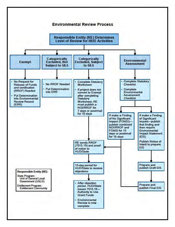
10 Level of Review EIS (the general trigger is 2500 units or beds or infrastructure that will or may provide capacity for 2500 but there are exceptions) Environmental Assessment Categorically Excluded Categorically Excluded NOT Subject to 58.5 Exempt
11 Exempt Activities 24 CFR Part 58.34(a) Environmental, planning & design costs Information & financial services Administrative/management activities Public services (no physical impact) Inspections Purchase of tools/insurance Technical assistance & training Temporary assist. for imminent threats Payment of principal and interest
12 Categorically Excluded Activities not subject to CFR 58.35(b) Tenant-based Rental assistance Supportive Services Operating costs (utilities, supplies) ED costs (non-construction) Pre-development costs Supplemental Assistance
13 Categorically Excluded subject to CFR 58.35(a) Public Facilities < 20% size/ capacity increase Projects for accessibility and mobility Rehab of Single Family (density not increased beyond 4 units, land use is not changed, and footprint is not increased in floodplain or wetland) Minor Rehab of Multi-family (no change in use, < 20% change in density, est. cost rehab <75% of total cost of replacement after rehab) Rehab of Nonresidential (no change in use, - < 20% change in density) Acquisition/Disposition no change in use
14 Environmental Assessment NEPA portion of the review: Designed to determine if an EIS is required Requires analysis of alternatives Requires early consultation Broad Interdisciplinary study
15
16 Public Notification EA: Combined Notice (FONSI and NOI) CE that triggers compliance: NOI/RROF only CE No Compliance Triggered None CE Not Subject to 58.5 : None Exempt: None
17 Public Comment Periods 24 CFR part TWO PUBLIC COMMENT PERIODS (1) NOI/FONSI - 15 days from Publication 18 days from Posting NOI - 7 days from Publication 10 days from Posting RE must consider comments prior to submitting its RROF to HUD/State (2) HUD/State Comment Period 15 days
18 Laws and Authorities 58.6/ Flood Insurance FEMA National Flood Insurance Program flood insurance is required if project is located within a Special Flood Hazard Area 100 year floodplain. The Flood Disaster Protection Act of 1973, as amended, requires that property owners purchase flood insurance for buildings located within Special Flood Hazard Areas (SFHA), when Federal financial assistance is used to acquire, repair, improve, or construct a building. Also required for insurable contents. Note that this is required by a statute and not the E.O This requirement will apply in many cases where the 8 Step process may not be applicable.
19 BUY FLOOD INSURANCE Duration of Flood Insurance Coverage. The statutory period for flood insurance coverage may extend beyond project completion. For loans, loan insurance or loan guarantees, flood insurance coverage must be continued for the term of the loan. For grants and other non-loan forms of financial assistance, flood insurance coverage must be continued for the life of the building irrespective of the transfer of ownership. Limits of NFIP coverage: $250,000 for residential and $500,000 for nonresidential structures. HUD recommends purchase for all insurable structures, but it is only required for those in the SFHA.
20 One Bite Rule One Bite Rule. HUD cannot offer Federal disaster assistance for a person s property for construction activities, where the person previously received Federal disaster assistance and failed to maintain the flood insurance. See 24 CFR 58.6(b). Translation: Failure to maintain flood insurance after using Federal disaster assistance jeopardizes Federal assistance following subsequent disasters.

21 Laws and Authorities 58.6 Coastal Barriers OTHER Clear Zones
22 Laws and Authorities 58.5 Historic Preservation Act Floodplain Management & Wetlands Protection: Executive Orders Coastal Zone Management Act Safe Drinking Water Act Endangered Species Act Wild & Scenic Rivers Act Clean Air Act Environmental Justice: Executive Order Aquifers Farmland Protection Act HUD Environmental Criteria & Standards Noise Abatement and Control Near Explosives or Flammable Sites Near Airport Runway Protection Zones Toxic Hazards

23 Laws and Authorities 58.5 Historic Preservation Section 106 Consultation Process
24 Historic Preservation: Tribal Consultation Must consult with appropriate tribes as part of Section 106 historic preservation process ouse HUD s Tribal Directory Assessment Tool to identify tribes interested in project area oreach out directly to tribe for consultation- the SHPO will not do this for HUD/RE
25 Laws and Authorities 58.5 Floodplains

26 Laws and Authorities 58.5 Avoid, minimize impacts, provide public notice

27 Is the site in a floodplain?


28 Floodplain Management 24 CFR Part 55 Applies to physical actions in 100yr: 1-4 family rehab if > 50% value buildings roads pipelines anything except minor clearing and grubbing

29 Be Aware of Cumulative Impacts
30 If you cannot avoid, minimize harm to lives and property limit fill of floodplain minimize grading relocate non-conforming structures preserve natural drainage use pervious surfaces / green alleys maintain buffers use detention ponds or rain gardens minimize tree cutting and destruction of wetland vegetation

31 Example of a FIRM
32 Preliminary Data for Disaster Assistance EO requires best available information 24 CFR 55 interprets this as FEMA finalized FIRMs Disaster notices requires the use of advisory maps by incorporation Other HUD programs only require enacted FIRMs
33 Advisory Maps The Disaster Recovery Enhancement Fund NOFA states that these grants are to be treated as the funds granted by this Hurricane Ike notice ( ). The Ike notice states at 24.M: The state certifies that it will not use CDBG disaster recovery funds for any activity in an area delineated as a special flood hazard area in FEMA s most current flood advisory maps, unless it also ensures that the action is designed or modified to minimize harm to or within the floodplain, in accordance with Executive Order and 24 CFR part 55.
 are occurring and current maps do not consider")


34 Sea-Level Rise and increases in extreme events (floods and droughts) are occurring and current maps do not consider trends or anticipated conditions (rearview): Washaway Beach, Cape Shoalwater, WA has been eroding an average of 100 feet per year for a century. In this Aug. 24, 2010, photo is a view looking east about a block from the tiny town of Minnewaukan, N.D.'s only school. Devils Lake, which was once 8 miles away, today is lapping at the community from three sides. (AP)

35 EO Protection of Wetlands Purpose is to avoid to the extent possible the long and short term adverse impacts associated with the destruction or modification of wetlands and to avoid direct or indirect support of new construction in wetlands wherever there is a practicable alternative*.+

36 National Wetlands Inventory Map *NWI maps are to be used from primary screening. Sites should be checked any time substantial filling, drainage, impounding, or other new construction activities occur.
, site planning around sensitive areas, and compensatory mitigation.")
37 Minimization Strategies Floodplain notices can be combined with wetlands Multiple locations can share notices and 8 Steps Minimization examples are manmade swales, permeable surfaces (e.g. green alleys), site planning around sensitive areas, and compensatory mitigation.
38 Toxics HUD policy that all properties are free of hazards, contamination that could affect the health and safety of occupants Multifamily projects require an ASTM Phase I Environmental Assessment or equivalent focus on Recognized Environmental Concern

39 Toxics info sources

40 Toxics info sources EDR Report
41 Environmental Review Record Written record of review Must be available for public inspections Let the file tell the story include project description, maps, photographs, studies, correspondence, public notices, etc.
42 Importance of Early Start Begin environmental review process as early as possible 58.30(b) Typical times required to complete range from 1 to 120 days Allow time for periods of public comment on environmental notices, including Finding of No Significant Impact (FONSI) and the Notice of Intent to Request Release of Funds (NOI-RROF)
43 Important Tips Recognize the additional time that will be required if the project is in the Floodplain, a wetland or has historic implications Responsible for ensuring flood insurance is maintained DON T SPEND A DIME until the environmental review is complete and you have received an approved Request for Release of Funds When in doubt, contact your local environmental officer!

44 New Compliance Tools


45 ATEC Tribal Directory Assessment Tool Section 106 Programmatic Agreement Database Noise Calculator Separation Distance Calculator

46 Questions Call your Field Environmental Officer! My contact info: p: e:
Environmental Review and Disaster Recovery
 Environmental Review and Disaster Recovery Welcome & Speakers Session Objectives Identify the importance of Environmental Reviews Identify tips for understanding post disaster Environmental Laws Determine
Environmental Review and Disaster Recovery
 Environmental Review and Disaster Recovery Welcome and Speakers Welcome to HUD s webinar series on CDBG-DR basics Webinars will focus on key rules and requirements for managing DR grants Webinars will
NEW YORK STATE HOME PROGRAM ENVIRONMENTAL REVIEW PROCEDURES FOR LOCAL PROGRAM ADMINISTRATOR (LPA) PROGRAMS
 PROGRAMS") NEW YORK STATE HOME PROGRAM ENVIRONMENTAL REVIEW PROCEDURES FOR LOCAL PROGRAM ADMINISTRATOR (LPA) PROGRAMS Photo: M. Binder For Website Distribution Issued: January 2016 TABLE OF CONTENTS THE HTFC LPA
NEW YORK STATE HOME PROGRAM ENVIRONMENTAL REVIEW PROCEDURES FOR LOCAL PROGRAM ADMINISTRATOR (LPA) PROGRAMS Photo: M. Binder For Website Distribution Issued: January 2016 TABLE OF CONTENTS THE HTFC LPA
Expediting the Federal Environmental Review Process in Indian Country
 Expediting the Federal Environmental Review Process in Indian Country Hilary Atkin HUD Office of Native American Programs 1 Michael Drummond Council on Environmental Quality Overview 2 o Coordinating Environmental
Procedures for NEPA Consultant hired by the County or the City
 Procedures for NEPA Consultant hired by the County or the City IMPORTANT: A NEPA REQUEST WITH A LOCAL GOVERNMENT CHECKLIST AND A FOOTPRINT NEEDS TO BE SUBMITTED TO ENVIRONMENTAL PROGRAMS DIVISION AND A
National Flood Insurance Program (NFIP)
") National Flood Insurance Program (NFIP) Programmatic EIS (PEIS) Informing our Understanding of the NFIP and the Environment ASFPM June 12, 2013 Overview/Outline After this Seminar you should know: Who
National Flood Insurance Program (NFIP) Programmatic EIS (PEIS) Informing our Understanding of the NFIP and the Environment ASFPM June 12, 2013 Overview/Outline After this Seminar you should know: Who
Billing Code DEPARTMENT OF HOUSING AND URBAN DEVELOPMENT. 24 CFR Parts 50, 55, and 58. [Docket No. FR-5423-F-02] RIN 2501-AD51
![Billing Code DEPARTMENT OF HOUSING AND URBAN DEVELOPMENT. 24 CFR Parts 50, 55, and 58. [Docket No. FR-5423-F-02] RIN 2501-AD51](/thumbs/95/125575111.jpg "Billing Code DEPARTMENT OF HOUSING AND URBAN DEVELOPMENT. 24 CFR Parts 50, 55, and 58. [Docket No. FR-5423-F-02] RIN 2501-AD51") This document is scheduled to be published in the Federal Register on 11/15/2013 and available online at http://federalregister.gov/a/2013-27427, and on FDsys.gov Billing Code 4210-67 DEPARTMENT OF HOUSING
This document is scheduled to be published in the Federal Register on 11/15/2013 and available online at http://federalregister.gov/a/2013-27427, and on FDsys.gov Billing Code 4210-67 DEPARTMENT OF HOUSING
Floodplain Management 101. Mississippi Emergency Management Agency Floodplain Management Bureau
 Floodplain Management 101 Mississippi Emergency Management Agency Floodplain Management Bureau Stafford Act The Stafford Disaster Relief and Emergency Assistance Act (Stafford Act) (Public Law 100-707)
Floodplain Management Annual Conference Atlanta, Georgia April 2017
 Floodplain Management 2017 Annual Conference Atlanta, Georgia April 2017 Floodplain Mapping and Flood Zones Zone Deisgnations: Zone A: No base flood elevations have been determined it is an approximated
ASFPM Partnerships for Statewide Mitigation Actions. Alicia Williams GIS and HMP Section Manager, Amec Foster Wheeler June 2016
 ASFPM Partnerships for Statewide Mitigation Actions Alicia Williams GIS and HMP Section Manager, Amec Foster Wheeler June 2016 Summary The Concept Leveraging Existing Data and Partnerships to reduce risk
COMMUNITY CERTIFICATIONS
 OMB No. xxxxxxxx Expires: xxxxxxxx National Flood Insurance Program Community Rating System COMMUNITY CERTIFICATIONS D R A F T CRS COMMUNITY CERTIFICATIONS The following community certifications are part
National Flood Insurance Program Final Nationwide Programmatic Environmental Impact Statement
 Final Nationwide Programmatic Environmental Impact Statement EXECUTIVE SUMMARY Action Agency: Federal Emergency Management Agency Cooperating Agency: U.S. Environmental Protection Agency September 2017
Article 23-6 FLOODPLAIN DISTRICT
 AMENDING THE CODE OF THE CITY OF PITTSFIELD CHAPTER 23, ZONING ORDINANCE SECTION I That the Code of the City of Pittsfield, Chapter 23, Article 23-6 Floodplain District, shall be replaced with the following:
COMBINED PUBLIC NOTICE
 COMBINED PUBLIC NOTICE NOTICE OF FINDING OF NO SIGNIFICANT IMPACT AND NOTICE OF INTENT TO REQUEST RELEASE OF FUNDS AND NOTICE AND PUBLIC EXPLANATION OF A PROPOSED ACTIVITY IN THE 100-YEAR FLOODPLAIN April
Floodplain Management Legal Issues. Making the Case for a No Adverse Impact Approach
 Floodplain Management Legal Issues Making the Case for a No Adverse Impact Approach The Association of State Floodplain Managers 2 ASFPM began more than 45 years ago as a grassroots organization of floodplain
FEMA s Non-Disaster Grant Programs
 FEMA s Non-Disaster Grant Programs KAMM Conference August 24, 2016 UK Hazard Mitigation Grants Program 1 Non-Disaster Grant Programs Pre-Disaster Mitigation (PDM) Flood Mitigation Assistance (FMA) 2 Non-Disaster
FREQUENTLY ASKED QUESTION ABOUT FLOODPLAINS Michigan Department of Environmental Quality
 FREQUENTLY ASKED QUESTION ABOUT FLOODPLAINS Michigan Department of Environmental Quality WHAT IS A FLOOD? The National Flood Insurance Program defines a flood as a general and temporary condition of partial
History of Floodplain Management in Ascension Parish
 History of Floodplain Management in Ascension Parish presented by: Kara Moree Floodplain Coordinator February 6, 2012 Floodplain 101 Floodplain 101 Base or 1% Flood: A flood having a 1% chance of being
CDBG-DR, BW-12, CRS and Dauphin County, PA: What do they have in common? 2015 FMA Annual Conference
 CDBG-DR, BW-12, CRS and Dauphin County, PA: What do they have in common? 2015 FMA Annual Conference September 9, 2015 Today's Speaker Kristen Gelino Hazard Mitigation Planner, Tetra Tech, Inc. 2 years
Hurricane SANDY DR-4086-NJ
 Public Assistance Applicant s Briefing Hurricane SANDY DR-4086-NJ State Coordinating Officer Lt Jeff Mottley Disaster Information Declaration Date October 30 th, 2012 Incident Period 10-26-2012 - On-Going
Volusia County Floodplain Management Plan 2012
 Volusia County Floodplain Management Plan 2012 Introduction The National Flood Insurance Program (NFIP) provides federally supported flood insurance in communities that regulate development in floodplains.
CDBG-DR, BW-12, CRS and Dauphin County, PA: What do they have in common? 2015 ASFPM Annual Conference
 CDBG-DR, BW-12, CRS and Dauphin County, PA: What do they have in common? 2015 ASFPM Annual Conference June 3, 2015 Today's Speaker Rob Flaner Hazard Mitigation Program Manager, Tetra Tech, Inc. Over 25
a) Ensure public safety through reducing the threats to life and personal injury.
 Ensure public safety through reducing the threats to life and personal injury.") SECTION VII: FLOODPLAIN DISTRICT 7-1 Statement Of Purpose The purposes of the Floodplain District are to: a) Ensure public safety through reducing the threats to life and personal injury. b) Eliminate
SECTION VII: FLOODPLAIN DISTRICT 7-1 Statement Of Purpose The purposes of the Floodplain District are to: a) Ensure public safety through reducing the threats to life and personal injury. b) Eliminate
The National Flood Insurance Program and Flood Insurance Rate Map for San Francisco. Presentation at Treasure Island Community Meeting
 The National Flood Insurance Program and Flood Insurance Rate Map for San Francisco Presentation at Treasure Island Community Meeting October 17, 2007 1 National Flood Insurance Program (NFIP) Overview
Planning Process---Requirement 201.6(b): An open public involvement process is essential to the development of an effective plan.
: An open public involvement process is essential to the development of an effective plan.") Section 3 Capability Identification Requirements Planning Process---Requirement 201.6(b): An open public involvement process is essential to the development of an effective plan. Documentation of the Planning
Section 3 Capability Identification Requirements Planning Process---Requirement 201.6(b): An open public involvement process is essential to the development of an effective plan. Documentation of the Planning
Welcome to a Silver Jackets Webinar
 Welcome to a Silver Jackets Webinar The CRS and Repetitive Loss Area Analysis (RLAA) For audio, Dial: 877 336-1839 Access code: 5884527 Security code: 4567 Visual 10.1 David A. Stroud, CFM Emergency &
National Capitol Region HAZUS User Group Call
 Listen to the recording here to follow along with the presentation: http://www.freeconferencecalling.com/recordings/recording.aspx?fileid=l AF3494_04252013070630062_1154707&bridge=697620&email=&account
Primer on Executive Order 11988: Floodplain Management
 Primer on Executive Order 11988: Floodplain Management There are new floodplain management requirements as a result of Executive Order 11988 and the expanded floodplain definition under Executive Order
Risk, Mitigation, & Planning
 Risk, Mitigation, & Planning Lessons from Flooding in the Houston Area Russell Blessing, Samuel Brody & Wesley Highfield CUMULATIVE FLOOD LOSS: 1972-2015 INSURED FLOOD LOSS: 1972-2015 THE HOUSTON-GALVESTON
CHAPTER 4. REGULATIONS AND DEVELOPMENT STANDARDS
 CHAPTER 4. REGULATIONS AND DEVELOPMENT STANDARDS Regulations and development standards, which can be used by communities to reduce damage from natural hazards, work best when using an effective planning
TS18 Mitigation Grant Application and Benefit Cost Analysis Development - Support Documentation - Governor s Hurricane Conference 2017
 TS18 Mitigation Grant Application and Benefit Cost Analysis Development - Support Documentation - Governor s Hurricane Conference 2017 Name Entity Your role with mitigation projects Your expectations /
California Building Code and the NFIP. John Ingargiola, Senior Engineer FEMA Building Science Branch
 California Building Code and the NFIP John Ingargiola, Senior Engineer FEMA Building Science Branch CA Major Disaster Declarations and Federal Assistance $21 $21 $76 $78 7 declarations, 2004-2016, total
RiskTopics. Guide to flood emergency response plans September 2017
 RiskTopics Guide to flood emergency response plans September 2017 While floods are a leading cause of property loss, a business owner can take actions to mitigate and even help prevent damage and costly
Flood Insurance THE TOPIC OCTOBER 2012
 Flood Insurance THE TOPIC OCTOBER 2012 Because of frequent flooding of the Mississippi River during the 1960s and the rising cost of taxpayer funded disaster relief for flood victims, in 1968 Congress
10/5/2015. What Makes a Sound Floodplain Management Program? What are the Flood Problems in your Community?
 The Community Rating System (CRS) and Hazard Mitigation Planning Preparing Your Community Through Common Program Goals September 3, 2015 What Makes a Sound Floodplain Management Program? Know your community
Flood Risk in the Schuylkill Watershed. Planning for Resilient Communities
 Flood Risk in the Schuylkill Watershed Planning for Resilient Communities Welcome to Our Poster Session! We are here to talk about: Flood Risk in the Schuylkill River Watershed Taking Action to Reduce
ENBRIDGE ENERGY LIMITED PARTNERSHIP SPECIAL USE PERMIT
 Page 1 of 6 Chequamegon- Nicolet National Forest ENBRIDGE ENERGY LIMITED PARTNERSHIP SPECIAL USE PERMIT Fact Sheet July 5, 2017 Situation: Enbridge Energy Limited Partnership (Enbridge) has requested to
Notice of Funding Availability (NOFA) for Applications for Credit Assistance under the
 for Applications for Credit Assistance under the") This document is scheduled to be published in the Federal Register on 04/12/2018 and available online at https://federalregister.gov/d/2018-07513, and on FDsys.gov 6560-50-P ENVIRONMENTAL PROTECTION AGENCY
This document is scheduled to be published in the Federal Register on 04/12/2018 and available online at https://federalregister.gov/d/2018-07513, and on FDsys.gov 6560-50-P ENVIRONMENTAL PROTECTION AGENCY
COASTAL HAZARD MITIGATION TOOLS AND TECHNIQUES
 COASTAL HAZARD MITIGATION TOOLS AND TECHNIQUES Beach Nourishment Responsible Agency/Party: Mitigation for: Management Effort: Federal and/or State sponsored projects Long- and short-term erosion Flood
Plan Implementation AICP Exam Review
 Plan Implementation AICP Exam Review GPA Fall Conference October 9, 2013 Gary A. Cornell, FAICP Outline of AICP Exam Content Visioning and goal setting Quantitative and qualitative research methods Collecting,
Changes in Criteria and Scoring for CRS Outreach Projects
 Changes in Criteria and Scoring for CRS Outreach Projects A Handout for the National Flood Insurance Program Community Rating System Many communities want to keep disseminating and obtaining CRS credit
*How Federal Policy. Causes Flood Disasters. Leslie A. Bond, CFM LA Bond Associates
 *How Federal Policy Causes Flood Disasters Leslie A. Bond, CFM LA Bond Associates *The high cost of flood disasters *We do not know what floods cost. *Published estimates do not include all costs of disasters.
Biggert-Waters Flood Insurance Reform and Modernization Act of 2012
 Biggert-Waters Flood Insurance Reform and Modernization Act of 2012 On July 6, 2012, President Obama signed into law the Biggert-Waters Flood Insurance Reform Act of 2012, which reauthorizes and reforms
Chapter 7 Appendix B: National Flood Insurance Program Summary for Kaua'i County, 2015 Update
 Chapter 7 Appendix B: National Flood Insurance Program Summary for Kaua'i County, 2015 Update Topic Considerations Description INSURANCE SUMMARY STAFF RESOURCES How many NFIP policies are in Kaua i County?
Federal Flood Risk Management Standards. An Update on Federal Flood Resilience Standards
 Federal Flood Risk Management Standards An Update on Federal Flood Resilience Standards Purpose of Today s Briefing Facilitate the understanding of Executive Order (E.O.)13690 and its implementation Discuss
NFIP Overview Elevation Certificate Flood Insurance Rate Maps. By: Maureen O Shea, AICP, CFM State NFIP Coordinator
 NFIP Overview Elevation Certificate Flood Insurance Rate Maps By: Maureen O Shea, AICP, CFM State NFIP Coordinator Example of a flood failure Example of a flood failure Purposes of the NFIP Identify &
CAPABILITY ASSESSMENT
 SECTION 7 CAPABILITY ASSESSMENT This section of the Plan discusses the capability of the communities in the Smoky Mountain Region to implement hazard mitigation activities. It consists of the following
COLLIER COUNTY FLOODPLAIN MANAGEMENT
 COLLIER COUNTY FLOODPLAIN MANAGEMENT FREQUENTLY ASKED QUESTIONS The following information is based on common questions from the public. If you have a specific question or need further information, please
Floodplain Development Permits A Technical Guidance Document
 Floodplain Development Permits A Technical Guidance Document To Prevent Loss of Life, Reduce Property Damage and to Protect and Enhance the Natural and Beneficial Functions of Floodplains Iredell County
National Institute of Building Sciences
 National Institute of Building Sciences Provider Number: G168 Improving the Flood Resistance of Buildings and Mitigation Techniques WE3B Peter Spanos, P.E., CFM, LEED AP (Gale Associates, Inc.) Stuart
C APABILITY A SSESSMENT
 PURPOSE The Rappahannock Rapidan region's capability assessment was conducted to determine the ability of participating localities to develop and implement a comprehensive hazard mitigation strategy and
Community Rating System. National Flood Insurance Program
 National Flood Insurance Program Community Rating System A Local Official s Guide to Saving Lives Preventing Property Damage Reducing the Cost of Flood Insurance FEMA B-573 / May 2015 How the Community
Simsbury. Challenges Capitol Region Natural Hazards Mitigation Plan Update - Page 356
 Simsbury Simsbury is a suburban community of about 23,600 located in the western portion of the Capitol Region. Its land area encompasses 33.9 square miles. Elevation in town generally ranges from about
Planning Process---Requirement 201.6(b): An open public involvement process is essential to the development of an effective plan.
: An open public involvement process is essential to the development of an effective plan.") Section 3 Capability Identification Requirements Planning Process---Requirement 201.6(b): An open public involvement process is essential to the development of an effective plan. Documentation of the Planning
Section 3 Capability Identification Requirements Planning Process---Requirement 201.6(b): An open public involvement process is essential to the development of an effective plan. Documentation of the Planning
Hazard Mitigation Grants. Technical Assistance Session Middlesex County, NJ December 7, 2011
 Hazard Mitigation Grants Technical Assistance Session Middlesex County, NJ December 7, 2011 Outline Purpose of Hazard Mitigation Hazard Mitigation Projects Hazard Mitigation Assistance Grant Programs Using
Reconstruction Implications
 Federal Emergency Management Agency (FEMA) Recovery Guidance Advisory Base Flood Elevation (ABFE) of April 12, 2006 Reconstruction Implications Presentation to: City of New Orleans July 6 th, 2006 Lambert
Modernization, FEMA is Recognizing the connection between damage reduction and
 EXECUTIVE SUMMARY Every year, devastating floods impact the Nation by taking lives and damaging homes, businesses, public infrastructure, and other property. This damage could be reduced significantly
SECTION 9: MAPS AND DATA
 SECTION 9: MAPS AND DATA Contents 9.1. NFIP Maps and Data... 9-2 9.1.1. Adopting and enforcing NFIP floodplain maps and data... 9-2 9.1.2. Adopting and enforcing more restrictive data... 9-2 9.1.3. Annexations...
Hazard Mitigation Overview
 Hazard Mitigation Overview Yahara Lakes Advisory Group April 28, 2011 1 Discussion Topics Recent flood losses and damages Hazard mitigation programs Project opportunities 2 Recent Flood Losses* Date May
Using GISWeb to Determine Your Property s Flood Zone
 Using GISWeb to Determine Your Property s Flood Zone 1. In a new browser window, go to http://www.co.santacruz.ca.us/departments/geographicinformationsystemsgis.aspx 2. Click on GISWeb - GIS Mapping Application
Natural Hazards Mitigation Plan. Executive Summary
 Natural Hazards Mitigation Plan Executive Summary 1. Introduction Kane County Illinois, is subject to natural hazards that threaten life and health and have caused extensive property damage. Floods struck
City of St. Augustine. Floodplain Management Higher Standards Information
 City of St. Augustine Floodplain Management Higher Standards Information There are different regulations that communities can use to help protect existing and future development and natural floodplain
Emergency Management. December 16, 2010
 Applications of Hazus-MH for Emergency Management December 16, 2010 What is Hazus-MH? Free ArcGIS extension Facilitates a risk-based approach to mitigation Identifies and visually displays hazards and
Bucks County, PA Flood Risk Review Meeting. November 2014
 Bucks County, PA Flood Risk Review Meeting November 2014 Agenda for Today Risk MAP Program overview Overview of non-regulatory Flood Risk Products and datasets Discuss mitigation action Technical overview
No An act relating to regulation of flood hazard areas, river corridors, and stream alteration. (S.202)
") No. 138. An act relating to regulation of flood hazard areas, river corridors, and stream alteration. (S.202) It is hereby enacted by the General Assembly of the State of Vermont: Sec. 1. 10 V.S.A. chapter
No. 138. An act relating to regulation of flood hazard areas, river corridors, and stream alteration. (S.202) It is hereby enacted by the General Assembly of the State of Vermont: Sec. 1. 10 V.S.A. chapter
Flood Risk and Climate Adaptation: Policy Reforms and Lessons (Being) Learned from Hurricane Sandy
 Learned from Hurricane Sandy") Flood Risk and Climate Adaptation: Policy Reforms and Lessons (Being) Learned from Hurricane Sandy Adaptive Planning For Coastal Change: Legal Issues For Local Government Briefing Overview 2 Background:
Flood Risk and Climate Adaptation: Policy Reforms and Lessons (Being) Learned from Hurricane Sandy Adaptive Planning For Coastal Change: Legal Issues For Local Government Briefing Overview 2 Background:
July 31, 2017 NFIP Flood Map Open House Flood Maps 101 Flood Mapping acronyms History of the NFIP Flood Mapping Updates Flood Insurance Fairhope,
 July 31, 2017 NFIP Flood Map Open House Flood Maps 101 Flood Mapping acronyms History of the NFIP Flood Mapping Updates Flood Insurance Fairhope, Alabama Flood Maps Fairhope Permitting Jurisdiction Coastal
Mitigation in a Changing Environment: Preserving our Heritage while Investing in Mitigation for a More Resilient Nation
 Mitigation in a Changing Environment: Preserving our Heritage while Investing in Mitigation for a More Resilient Nation Miami Design Preservation League 2nd Annual Resiliency Workshop April 7, 2018 Nick
ASFPM Update and NFIP Reform. KAMM 10 th Anniversary Conference September 9, 2014
 ASFPM Update and NFIP Reform KAMM 10 th Anniversary Conference September 9, 2014 AND HE SAID Floods are 'acts of God,' but flood losses are largely acts of man. 1945 PhD Dissertation Human Adjustments
Aquidneck Island Resilience Strategy Issue Paper 4. Issue: RESIDENTIAL FLOODING
 Aquidneck Island Resilience Strategy Issue Paper 4 Issue: RESIDENTIAL FLOODING Description of Concern: While much of Aquidneck Island s geography lies outside the reach of coastal flooding, some of the
10526 Bermuda Isle Dr. Tampa, FL 33647
 Flood Analysis Memo Property Address 10526 Bermuda Isle Dr. In Partnership with: ** This property is NOT within a high-risk flood zone ** 10526 Bermuda Isle Dr. BFE = 35 ft This property is located in
NFIP Reform Proposals
 Enclosure NFIP Reform Proposals Below is a summary of proposals to reform the National Flood Insurance Program (NFIP) that the Administration supports, many of which Members of Congress have strongly supported
CHAPTER THREE Natural Hazard Mitigation Strategy
 CHAPTER THREE Natural Hazard Mitigation Strategy Chapter 3 Section All Sections Updates to Section Revised Natural Hazards Introduction and all Sections to change Natural Hazards Subcommittee to Committee.
Town of Montrose Annex
 Town of Montrose Annex Community Profile The Town of Montrose is located in the Southwest quadrant of the County, east of the Town of Primrose, south of the Town of Verona, and west of the Town of Oregon.
Public Works and Development Services
 City of Commerce Capital Improvement Program Prioritization Policy Public Works and Development Services SOP 101 Version No. 1.0 Effective 05/19/15 Purpose The City of Commerce s (City) Capital Improvement
CHAPTER 15: FLOODPLAIN OVERLAY DISTRICT "FP"
 CHAPTER 15: FLOODPLAIN OVERLAY DISTRICT "FP" SECTION 15.1 STATUTORY AUTHORIZATION The legislature of the State of Minnesota in Minnesota Statutes, Chapter 103F and Chapter 394 has delegated the responsibility
Upper Joachim Creek Public Survey on Potential Flood Risk Reduction
 Upper Joachim Creek Public Survey on Potential Flood Risk Reduction This survey is intended to help the interagency planning committee to receive public feedback on specific flood risk reduction techniques,
ADVISORY BASE FLOOD ELEVATIONS (ABFEs)
") The Department of Homeland Security s Federal Emergency Management Agency is committed to helping communities that were impacted by Hurricanes Katrina and Rita rebuild safer and stronger. Following catastrophic
The Department of Homeland Security s Federal Emergency Management Agency is committed to helping communities that were impacted by Hurricanes Katrina and Rita rebuild safer and stronger. Following catastrophic
Neighborhood Housing Services of Queens, CDC. Heather Spitzberg, Director, Environmental Analysis Unit
 Environmental Review for Activity/Project that is Exempt or Categorically Excluded Not Subject to Section 58.5 Pursuant to 24 CFR Part 58.34(a) and 58.35(b) Project Information Program Name: NHSQ CDC HOME
Pre-Development Floodplain Application
 Pre-Development Floodplain Application The Department of Planning, at the recommendation of FEMA, is now requiring completion of a Pre- Development Floodplain Application for all properties in the regulated
Public Notice. Proposed anchor structures, dredging, and discharge at the Enbridge Line 5 pipeline in the Straits of Mackinac, Michigan
 US Army Corps of Engineers Detroit District Public Notice Applicant: Enbridge Pipelines (Lakehead), LLC In Reply Refer To: Corps File No. LRE-2010-00463-56-N18 Date: January 29, 2019 Expires: February
Repetitive Loss Area Revisit # 6 Walter Road Area Jefferson Parish
 Repetitive Loss Area Revisit # 6 Walter Road Area Jefferson Parish www.floodhelp.uno.edu Supported by FEMA Acknowledgement The compilation if this report was managed by Erin Patton, CFM, a UNO-CHART Research
SECTION V THE LOCAL MITIGATION STRATEGY BLUEPRINT
 SECTION V THE LOCAL MITIGATION STRATEGY BLUEPRINT A. GUIDING MITIGATION PRINCIPLES The Local Mitigation Strategy (LMS) is Hillsborough County s program developed to reduce or eliminate all forms of losses
National Flood Insurance Program (NFIP) for Real Estate Professionals
 for Real Estate Professionals") National Flood Insurance Program (NFIP) for Real Estate Professionals 1 Joshua Oyer, CFM Outreach Specialist NFIP State Coordinator s Office at the Texas Water Development Board 2 Outline Introduction
National Flood Insurance Program (NFIP) for Real Estate Professionals 1 Joshua Oyer, CFM Outreach Specialist NFIP State Coordinator s Office at the Texas Water Development Board 2 Outline Introduction
Elevating Historic Properties
 Elevating Historic Properties HISTORIC PRESERVATION COMMISSION Guide The Mississippi Development Authority (MDA) has developed Elevation Design Guidelines to assist owners of all properties determined
Mapping Flood Risk in the Upper Fox River Basin:
 Mapping Flood Risk in the Upper Fox River Basin: Vulnerable Populations and Adverse Health Effects Presented by: Angelina Hanson STUDY AREA: Wisconsin's Upper Fox River Basin Total Population 139,309.
Army Corps of Engineers Indianapolis North Questions and Answers July QUESTION 1: What is the Indianapolis White River North project?
 Army Corps of Engineers Indianapolis North Questions and Answers July 2012 QUESTION 1: What is the Indianapolis White River North project? ANSWER 1: The project involves construction of floodwalls and
King County Flood Control District Flood Risk Reduction Work Program and Accomplishments
 King County Flood Control District Flood Risk Reduction Work Program and Accomplishments Brian Murray Water and Land Resources Division April 26, 2016 Department of Natural Resources and Parks Water and
Flood Insurance vs. Disaster Assistance. Janice Mitchell FEMA, Region
 Flood Insurance vs. Disaster Assistance Janice Mitchell FEMA, Region 4 770-220-5441 National Flood Insurance Program (NFIP) Nearly 20,000 communities participating 195,350,633 policies in force $37,417,000,898,700
Project Information. SHARS Number: (Name and Title) Tarrytown, NY Telephone:
 Tarrytown, NY Telephone:") Environmental Review for Activity/Project that is Exempt or Categorically Excluded Not Subject to Section 58.5 Pursuant to 24 CFR Part 58.34(a) and 58.35(b) Project Information Program Name: Opening Doors
Environmental Review for Activity/Project that is Exempt or Categorically Excluded Not Subject to Section 58.5 Pursuant to 24 CFR Part 58.34(a) and 58.35(b) Project Information Program Name: Opening Doors
GIS - Introduction and Sample Uses
 PDHonline Course L145 (5 PDH) GIS - Introduction and Sample Uses Instructor: Jonathan Terry, P.L.S. 2012 PDH Online PDH Center 5272 Meadow Estates Drive Fairfax, VA 22030-6658 Phone & Fax: 703-988-0088
Key Fundamentals of Flood Insurance in the NFIP!
 a Welcome to Key Fundamentals of Flood Insurance in the NFIP! A Before and After approach for Housing Counselors Presented by: 1 Before the Flood Presenter Melanie Graham After the Flood Presenter Erin
JAXGIS FEMA Flood Hazard Mapping -- Frequently Asked Questions
 Flood Hazard Zone Designations Summary Zones starting with the letter 'A' (for instance, Zone A, Zone AE, Zone AH, Zone AO) denote a Special Flood Hazard Area, which can also be thought of as the 100-year
Door County Floodplain Program Informational Meeting
 Door County Floodplain Program Informational Meeting Door County Land Use Services Department Wisconsin Department of Natural Resources January 15, 2018 Floodplain = Land affected by flood event with a
AMENDMENTS TO CHAPTER 50: FLOODPLAIN DEVELOPMENT
 AMENDMENTS TO CHAPTER 50: FLOODPLAIN DEVELOPMENT PART I: 2018 FLOOD MAP IMPLEMENTATION PART II: STRATEGIES TO IMPROVE THE CITY S COMMUNITY RATING SYSTEM SCORE NATIONAL FLOOD INSURANCE PROGRAM (NFIP) CREATED
Public Assistance: Local, State, Tribal and Non-Profit
 Public Assistance: Local, State, Tribal and Non-Profit The mission of the Federal Emergency Management Agency's (FEMA) Public Assistance (PA) Grant Program is to provide assistance to State, Tribal and
Appendix B. A Comparison of the Minimum NFIP Requirements and the CRS
 A Comparison of the Minimum s and the CRS The Community Rating System provides credits for exceeding the minimum requirements of the National Flood Insurance Program (NFIP). Many local officials are not
A Review of Our Legacy System, History of Neglect, Current Issues, and the Path Forward for Levee Safety
 4 th NACGEA GEOTECHNICAL WORKSHOP January 29, 2010 A Review of Our Legacy System, History of Neglect, Current Issues, and the Path Forward for Levee Safety Presented by: Leslie F. Harder, Jr., Phd, PE,
TOWN OF KENT, CT PLANNING AND ZONING COMMISSION
 TOWN OF KENT, CT PLANNING AND ZONING COMMISSION FLOOD PLAIN MANAGEMENT REGULATIONS Whereas, Congress has determined that a National Flood Insurance Program would alleviate personal hardships and economic
Flood Risk Outreach Tools for Georgia Communities. GAFM 10 th Annual Conference Presented By: Jarrett Mattli
 Flood Risk Outreach Tools for Georgia Communities GAFM 10 th Annual Conference Presented By: Jarrett Mattli April 13, 2016 Presentation Overview Guidebooks Toolkits Templates Educational Videos Resource