FEMA Modeling Task Force (MOTF) Hurricane Sandy Response. MOTF Hurricane Sandy Response Briefing USGS NEIC Monday, May 13th, 2013
|
|
|
- Marybeth McCoy
- 6 years ago
- Views:
Transcription


1 FEMA Modeling Task Force (MOTF) Hurricane Sandy Response MOTF Hurricane Sandy Response Briefing USGS NEIC Monday, May 13th, 2013
2 Outcome Based Results FEMA s Modeling Task Force On-call, distributed analysis Real-time analysis to affect decisions Civil Air Patrol/NOAA collected 157,000+ images Over 147,000 individual structural assessments 44,000+ applicants received expedited rental assistance Supported multiple interagency programs Ability to Innovate 2
3 MOTF Aligns to NRCC Organization Mitigation Directorate, Risk Analysis Division Two Regions IV and VIII Three Subject Matter Experts Two Physical Scientists MT Earthquake Program One Regional Geospatial Coordinator (RGC) Eight Analysts GIS, Risk, Vulnerability Situational Awareness Section Chief Geospatial and Technical Group Supervisor Remote Support: Denver, CO GIS Unit Leader Technical Unit Leader Modeling Task Force (MOTF) 3
4 FEMA Modeling Task Force (MOTF) Overview The FEMA Modeling Task Force (MOTF) has been formally utilized for a number of Level 1 events, most recently Hurricane Sandy but also for Hurricane Isaac and Hurricane Irene. The MOTF plays an important role in coordinating hazard and modeling information from a variety of sources, including other federal agencies, universities, the National Labs, and State and local agencies, to develop consensus for best estimates of impacts before, during, and after events.
5 Sandy Activation FEMA Modeling Task Force (MOTF) was activated with assistance from the GIO and Future Planning to support the NRCC consistent with the FEMA GeoConops on October 26th MOTF team member working directly with the National Hurricane Center storm surge modeling team in Miami as part of HLT (Oct. 23rd), from RIV in Atlanta supporting the wind loss modeling and the remainder of the team working from FEMA Region VIII in Denver. 5
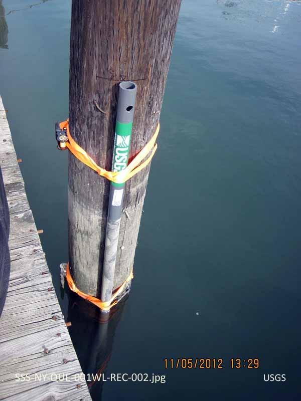
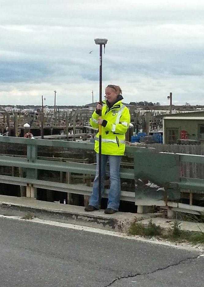
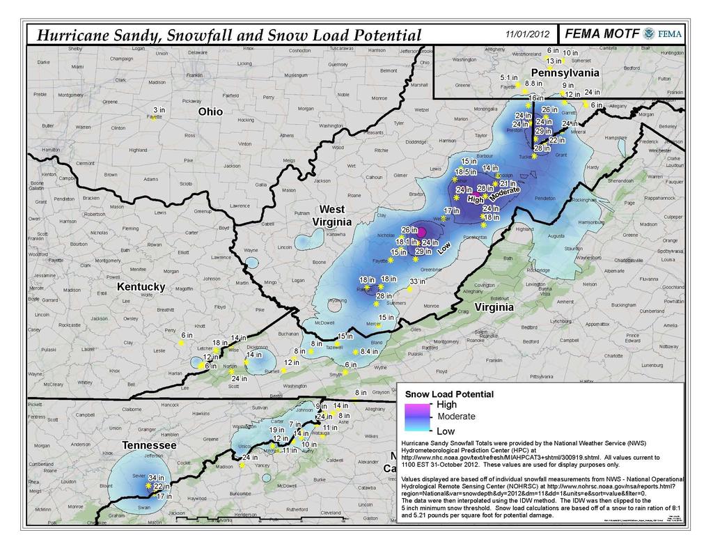
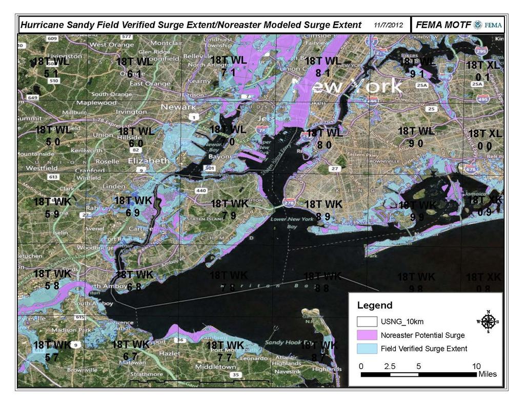
6 Hurricane Sandy MOTF Timeline NRCC Activation, USGS MA s HLT Deployment (Oct 23), Hurricane Sandy County Risk Matrix (QPF, Wind loss, CFLA, SLOSH models), MOTF portal Oct 26 High resolution (3 ft LiDAR) observed inundation NYC OEM, Nor easter surge modeling Hybrid hindcast SLOSH, preliminary HWM observations (±150), expedited rental assistance, portal updates Oct 29 Landfall Migration to impact analysis, Hindcast SLOSH, portal updates Nov 1 Nov 5 Field verified inundation (±300 observations), medium resolution (10 meter), portal, expedited assistance, NFIP updates Nov 7 Nov 11 Field verified inundation (±1,000 observations), high resolution, LiDARbased, major portal, expedited assistance, NFIP updates
7 Individual Assistance Damage Levels Assessment Source Inundation Model to Observations Imagery Assessment IA Inspection (FVL) Applications Affected Slight Minor Major Destroyed Housing Task Force Building Inspection Response Substantial Damage Estimation Debris Estimation
")

8 Hurricane Sandy Risk Matrix-Pre-Landfall The relative County risk is based on the following inputs: Precipitation (QPF) High: 8 or greater Medium: 4 to 7 Low: Less than 4 Hurricane Storm Surge and Wind Loss: High: >$100M Medium: $10-$100M Low: <$10M

9 Hurricane Sandy County Impact Analysis Post landfall, the Risk Matrix evolved into a County Impact Analysis using field verified data. Surge is the primary driver of severe impacts as a result of Hurricane Sandy and the relative impact assessment is summarized as follows:

10 Hurricane Sandy County Impact Analysis

11 Extensive metadata and download link: /
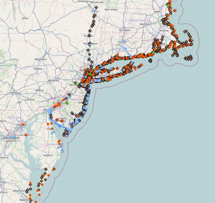
12 Hazard Identification Sandy
13
14 14
15 Inaccessible Zip + 4 Point Locations High resolution data points, average of 3 households per Zip + 4 in NJ and NY. located in USNG 1km x 1km grid cells with accessibility constraints as a result of significant road closures, or were exposed to >3 (later 5) feet of inundation based on the NHC surge model supplemented with available USGS field observations FEMA expedited $130M in rental payments to 44K applicants, allowed survivors to relocate while waiting for inspection process Saved $4M in inspection costs 15
16 Recovery Over Time of Inaccessible Zip

17 Recovery of Inaccessible Zip

18 Recovery of Inaccessible Zip


19 Analysis for NFIP Impacts Flood depths assigned to 200,000+ policies Integrated into request to increase borrowing authority $9.7 billion
20
21
22 History of NEIC Collaboration Extensive scenario support (NLE 2011) Development of PAGER action levels Event coordination (San Simeon, Kiholo Bay, Parkfield, Mt Carmel, Haiti, Mineral, etc.) Twitter Earthquake Detector
 ) d Vi los ew se er s s Pr Pr el im in ak ak ep em e ic Oc ap en PA (p cu te GE oi r rs nt & R so m (e ag xp ur ni ce os tu ) ur de e) (U of U, Ea rth ) Earthquake Information Timeline")
23 0 Sh 5min qu 10-20min 40min HA Z PA GE R el im in ar y ar y (a le rt a US GS EN S nd Sh US ak lo ss em es a ) PA p (w GE / f R aul (a t; a Up le d rt di da an tio te Fe d d na lo l e d HA s s da s es ta an ZUS ) ) d Vi los ew se er s s Pr Pr el im in ak ak ep em e ic Oc ap en PA (p cu te GE oi r rs nt & R so m (e ag xp ur ni ce os tu ) ur de e) (U of U, Ea rth ) Earthquake Information Timeline 1hr 2hrs 24hrs Did You Feel It?
24 Future NEIC Collaboration Extensive scenario support PAGER development building inventory data Event coordination Twitter Earthquake Detector-location, severity information, Tweak the Tweet (TtT)
25 USGS MA History Mission Assignments: Used for life-saving, lifesustaining, high-priority missions Federal Operations Support Scientific applications can t be done under MA s Must be outside existing authorities Very fast: can be done under verbal's Completed for Irene, Isaac, Minot, etc.
26 USGS MA Future Prescripted MA s USAR (urban search and rescue) aftershock warning Post event rockfall hazard mitigation
27 Expediting Assistance in Future Earthquakes Several plausible scenarios demonstrate significant potential IA inspection requirements. 60K were completed for Northridge, 6K for Mineral, +300K for potential scenarios Potential ShakeCast threshold based approach for Zip +4 damage levels Pre-identify vulnerability based on median yearbuilt, Hazus building and code level distributions, and loss ratios


28 Questions? FEMA MOTF Team:
National Capitol Region HAZUS User Group Call
 Listen to the recording here to follow along with the presentation: http://www.freeconferencecalling.com/recordings/recording.aspx?fileid=l AF3494_04252013070630062_1154707&bridge=697620&email=&account
National Capitol Region HAZUS User Group Call. December 19, :00 AM EST
 National Capitol Region HAZUS User Group Call December 19, 2013 10:00 AM EST NCR HUG Call Details Conference Call Details: 1. Dial-in: 1-267-507-0240 2. Conference code: 697620 Join the Meeting through
Challenges in Mitigation of NYU Langone Medical Center after Hurricane Sandy
 2016 GAFM Technical Conference Challenges in Mitigation of NYU Langone Medical Center after Hurricane Sandy Ranko S. Pudar, PE, CFM, PMP Institutional Use of BCA Benefit-Cost Analysis used by several federal
Mike Waters VP Risk Decision Services Bob Shoemaker Sr. Technical Coordinator. Insurance Services Office, Inc
 Mike Waters VP Risk Decision Services Bob Shoemaker Sr. Technical Coordinator Insurance Services Office, Inc Disasters Large and Small A Convergence of Interests Public and Private ESRI Homeland Security
Location: Tampa, Florida March 6, 2013
 Discovery Meeting: West Florida Coastal Study Location: Tampa, Florida March 6, 2013 Agenda Introductions Why we are here Outline Risk MAP products and datasets Discovery Overview: Project scoping and
1 Rare Hazard event is not likely to occur within 100 years. 2 Occasional Hazard event is likely to occur within 100 years
 5.3 HAZARD RANKING After the hazards of concern were identified for Onondaga County, the hazards were ranked to describe their probability of occurrence and their impact on population, property (general
SAFETY MANAGEMENT SYSTEMS (SMS) IMPLEMENTATION PERSPECTIVES
 IMPLEMENTATION PERSPECTIVES") Seattle Tacoma International Airport Perspectives of Early SMS Adopters San Antonio, TX March 22, 2011 SAFETY MANAGEMENT SYSTEMS (SMS) IMPLEMENTATION PERSPECTIVES Applying a Quality Management System to
Seattle Tacoma International Airport Perspectives of Early SMS Adopters San Antonio, TX March 22, 2011 SAFETY MANAGEMENT SYSTEMS (SMS) IMPLEMENTATION PERSPECTIVES Applying a Quality Management System to
Challenges in Mitigation of NYU Langone Medical Center after Hurricane Sandy
 2015 ASFPM National Conference Challenges in Mitigation of NYU Langone Medical Center after Hurricane Sandy Ranko S. Pudar, PE, CFM, PMP 2012 Hurricane Sandy Total death toll 285 (125 US) $62 billion in
The Citadel. Multi-Hazard Mitigation Disaster Resistant University Plan
 The Citadel Multi-Hazard Mitigation Disaster Resistant University Plan Project Objective To Develop a Disaster Resistant University Hazard Mitigation Plan Identify Hazards Profile Hazards Inventory Assets
SOUTH CENTRAL REGION MULTI-JURISDICTION HAZARD MITIGATION PLAN. Advisory Committee Meeting September 12, 2012
 SOUTH CENTRAL REGION MULTI-JURISDICTION HAZARD MITIGATION PLAN Advisory Committee Meeting September 12, 2012 AGENDA FOR TODAY Purpose of Meeting Engage All Advisory Committee Members Distribute Project
A Flood Mitigation Plan for the Non-Tidal N.J. Section of the Delaware River Basin. Sussex County Kick-off Meeting November 28, 2006
 A Flood Mitigation Plan for the Non-Tidal N.J. Section of the Delaware River Basin Sussex County Kick-off Meeting November 28, 2006 The Delaware River. crosses many boundaries Four states: DE, PA, NJ,
Garfield County NHMP:
 Garfield County NHMP: Introduction and Summary Hazard Identification and Risk Assessment DRAFT AUG2010 Risk assessments provide information about the geographic areas where the hazards may occur, the value
VULNERABILITY ASSESSMENT
 SOUTHSIDE HAMPTON ROADS HAZARD MITIGATION PLAN VULNERABILITY ASSESSMENT INTRODUCTION The Vulnerability Assessment section builds upon the information provided in the Hazard Identification and Analysis
County of Kaua'i Multi-Hazard Mitigation and Resilience Plan, 2015 Update
 Executive Summary: County of Kaua'i Multi-Hazard Mitigation and Resilience Plan Introduction to the Mitigation and Resilience Plan In this third plan, the longer term needs for sustaining mitigation efforts
Catastrophe Models: Learning from Superstorm Sandy
 Catastrophe Models: Learning from Superstorm Sandy January 2013 Lockton Companies Although Superstorm Sandy was only a Category 1 hurricane, it made landfall on October 29 as the largest Atlantic hurricane
Individual Assistance Preliminary Damage Assessment. Train the Trainer
 Individual Assistance Preliminary Damage Assessment Train the Trainer 1 2 DAMAGE ASSESSMENT What is it? The systematic process of determining and appraising the extent of loss, suffering and/or harm to
Preliminary Work Map Release
 Coastal Mapping in New Jersey Preliminary Work Map Release Monmouth County, New Jersey June 14, 2013 Agenda Introduction and Purpose of Briefing Hurricane Sandy Advisory Base Flood Elevations Transitioning
Sea Level Rise and the NFIP
 Cheryl A Johnson, PE, CFM, PMP March 26, 2014 http://www.globalchange.gov/ Sea-level rise and the likely increase in hurricane intensity and associated storm surge will be among the most serious consequences
Understanding CCRIF s Hurricane, Earthquake and Excess Rainfall Policies
 Understanding CCRIF s Hurricane, Earthquake and Excess Rainfall Policies Technical Paper Series # 1 Revised March 2015 Background and Introduction G overnments are often challenged with the significant
Risk Assessment Training Cape May County, NJ. FEMA REGION II December 13, :00 pm
 Risk Assessment Training Cape May County, NJ FEMA REGION II December 13, 2011 1:00 pm Agenda Welcome and Introductions Objectives NJ Disaster Recovery Efforts Risk MAP Non-Regulatory Products & Risk Assessment
Oklahoma High Water Marks. CTP Community of Practice April 20, 2017
 Oklahoma High Water Marks CTP Community of Practice April 20, 2017 The Rains Came into Region 6 in May 2015 2 Disaster DR-4222 30 Day Rainfall 3 NOAA Rainfall Amounts / Rainfall Frequency 4 The Rains in
A Flood Mitigation Plan for the Non-Tidal N.J. Section of the Delaware River Basin. Mercer County Kick-off Meeting December 6, 2006
 A Flood Mitigation Plan for the Non-Tidal N.J. Section of the Delaware River Basin Mercer County Kick-off Meeting December 6, 2006 The Delaware River. crosses many boundaries Four states: DE, PA, NJ, NY
State Risk and Insurance Management Association A Workshop About FEMA, Insurance, and The Recovery Process
 State Risk and Insurance Management Association A Workshop About FEMA, Insurance, and The Recovery Process Presented by: David M. Shapiro, DMS Disaster Consultants Jeb McPherson, Marsh & McLennan Companies
GAFM Showcase: Multiple Agencies Combating Georgia s Flood Risk Together: Proven Results Gained by Strong Partnerships
 National Flood Insurance Program Participation GAFM Showcase: Multiple Agencies Combating Georgia s Flood Risk Together: Proven Results Gained by Strong Partnerships Moderator: Jill Bazinet, PE, CFM GAFM
Survey of Hazus-MH: FEMA s Tool for Natural Hazard Loss Estimation
 Survey of Hazus-MH: FEMA s Tool for Natural Hazard Loss Estimation What is Hazus? Software tools and support system designed by FEMA for the purpose of providing communities with the means to identify
Individual Flood Preparedness Decisions During Hurricane Sandy in New York City By prof.dr. Wouter Botzen
 Individual Flood Preparedness Decisions During Hurricane Sandy in New York City By prof.dr. Wouter Botzen Agenda 1. Context: Individual adaptation measures in flood risk management 2. Flood risk management
Administrative Review Process for Hurricane Sandy Claims
 Administrative Review Process for Hurricane Sandy Claims Initial Outreach Letter FEMA will notify National Flood Insurance Program policyholders who experienced flooding due to Hurricane Sandy that they
Georgia Silver Jackets Team
 Georgia Silver Jackets Team 9 th Annual GAFM Technical Conference Jeff Morris GA SJ Collaborator Savannah District, USACE US Army Corps of Engineers SMART GOVERNMENT Integrate and synchronize flood risk
NFIP Program Basics. KAMM Regional Training
 NFIP Program Basics KAMM Regional Training Floodplain 101 Homeowners insurance does not cover flood damage Approximately 25,000 flood insurance policies in KY According to BW12 analysis, approximately
Kentucky Risk MAP It s not Map Mod II
 Kentucky Risk MAP It s not Map Mod II Risk Mapping Assessment and Planning Carey Johnson Kentucky Division of Water carey.johnson@ky.gov What is Risk MAP? Risk Mapping, Assessment, and Planning (Risk MAP)
Regional Economic Conditions & Assessing the Aftermath of Sandy
 Regional Economic Conditions & Assessing the Aftermath of Sandy Jason Bram, Senior Economist November 29, 2012 The views expressed here are those of the presenters and do not necessarily represent the
Middlesex County Timeline
 Community Coordination Meeting for Middlesex County, Connecticut Risk MAP Study November 9, 2011 Agenda Welcome and Introductions Project Timeline Coastal Flood Hazard Analysis Recap Public Review and
Damage Assessment It s More than Just Paperwork
 Damage Assessment It s More than Just Paperwork 1 Damage Assessment Strategy The Objective of this Strategy: To enable the County-wide Municipalities and local damage assessment teams understand, conduct
Hurricane Sandy: Disaster Recovery Best Practices & Lessons Learned. Robert DiLossi Director Crisis Management SunGard. Agenda
 Hurricane Sandy: Disaster Recovery Best Practices & Lessons Learned Robert DiLossi Director Crisis Management SunGard Agenda SunGard Response and Readiness Hurricane Sandy Timeline Lessons from Sandy and
Coastal Flood Maps. Chris Penney. Program Manager USACE Baltimore District 2 June US Army Corps of Engineers BUILDING STRONG
 Coastal Flood Maps Chris Penney Program Manager USACE Baltimore District 2 June 2015 US Army Corps of Engineers There are two types of coastal flood risk maps They look different They communicate different
Emergency Management. Alden Graybill, Recovery / Mitigation Division Manager, OEM
 Emergency Management Alden Graybill, Recovery / Mitigation Division Manager, OEM Our Mission To minimize the effects of all disasters and emergencies upon the people of Oklahoma through mitigation, preparedness,
Comparing HAZUS Flood Loss Estimates Across Hazard Identification Methods and Building Stock Inventory Data. Albion Township Dane County, Wisconsin
 Across Hazard Identification Methods and Building Stock Inventory Data Albion Township Dane County, Wisconsin Prepared for the Association of State Floodplain Managers September 1, 2010 Across Various
Cameron County, TX. Consultation Coordination Officer (CCO) Meeting. Please sign in (sheet at front of the room) Meeting will begin at 9:00
 Meeting. Please sign in (sheet at front of the room) Meeting will begin at 9:00") Cameron County, TX Consultation Coordination Officer (CCO) Meeting Please sign in (sheet at front of the room) Meeting will begin at 9:00 July 29, 2015 Lisa Jennings FEMA Region 6 Roles & Responsibilities
Cameron County, TX Consultation Coordination Officer (CCO) Meeting Please sign in (sheet at front of the room) Meeting will begin at 9:00 July 29, 2015 Lisa Jennings FEMA Region 6 Roles & Responsibilities
Decision-makers Barriers to Climate and Extreme Weather Adaptation for Seaports
 Decision-makers Barriers to Climate and Extreme Weather Adaptation for Seaports ELIZABETH L MCLEAN, PHD AUSTIN BECKER, PHD DUNCAN MCINTOSH, PHD DEPARTMENT OF MARINE AFFAIRS UNIVERSITY OF RHODE ISLAND Chris
Flooding and the Public: Experiences from SC flooding events in 2015 and 2016
 Flooding and the Public: Experiences from SC flooding events in 2015 and 2016 Maria Cox Lamm, CFM State Coordinator SCDNR Flood Mitigation Program www.dnr.sc.gov/flood Public Reaction to Flooding Would
Full file at CHAPTER 3
 CHAPTER 3 Adjusting the Accounts ASSIGNMENT CLASSIFICATION TABLE Study Objectives Questions Brief Exercises Exercises A Problems B Problems *1. Explain the time period assumption. 1, 2 *2. Explain the
National Capitol Region HAZUS User Group Call
 Click here to listen to the audio. National Capitol Region HAZUS User Group Call June 28, 2017 11:00 AM ET NCR HUG Call Details Conference Call Details: 1. Dial-in: 1-712-770-8023 2. Conference code: 926757
Congressional Budget Office
 Congressional Budget Office November 2, 2017 Effects of Climate Change and Coastal Development on U.S. Hurricane Damage: Implications for the Federal Budget Interagency Forum on Climate Risks, Impacts,
Test plan general view
 T2S COMMUNITY TEST Test plan general view 22 nd 17 th April 2015 Formatted: Superscript Version 2.01 Content 1.0 INTRODUCTION 4 2.0 TEST APPLICABILITY 4 3.0 TEST SUPPORT 6 4.0 TESTING OUTCOME 7 5.0 SET-UP
North Atlantic Coast Comprehensive Study: Resilient Adaption to Increasing Risk
 North Atlantic Coast Comprehensive Study: Resilient Adaption to Increasing Risk U.S. Army Corps of Engineers Coastal Storm Risk Management Planning Center of Expertise Amy M. Guise, USACE 21 November 2013
Lake County Hazard Identification and Risk Assessment Plan Lake County Hazard Mitigation Committee
 Lake County Hazard Identification and Risk Assessment Plan Lake County Hazard Mitigation Committee Request for Proposals Bid Deadline: Hard Copy Due 4:00 PM Mountain Standard Time (MST) Friday March 9,
This discussion provides information related to the damage assessment process and discusses the roles and impact of local and county government.
 Introduction This discussion provides information related to the damage assessment process and discusses the roles and impact of local and county government. EVENT Local/State Damage Assessment Survey
EXECUTIVE SUMMARY. Greater Greenburgh Planning Area Planning Process
 EXECUTIVE SUMMARY The Greater Greenburgh Planning Area All-Hazards Mitigation Plan was prepared in response to the Disaster Mitigation Act of 2000 (DMA 2000). DMA 2000 requires states and local governments
Region VIII Applications of Nationwide HAZUS Flood and Earthquake Modeling-Multi
 Region VIII Mitigation GIS Region VIII Applications of Nationwide HAZUS Flood and Earthquake Modeling-Multi Multi- Hazard Vulnerability Index 22 May 2009, EF-3 Tornado Forms in Northern Colorado http://www.allamericanpatriots.com/48747834_colorado-gov-ritter-issues-formal-disaster-declara
Authors: Terry Zien, Brian Rast and the Silver Jackets Co presenters: Brian Rast, Dave Lupardus and Frank Dolan
 Authors: Terry Zien, Brian Rast and the Silver Jackets Co presenters: Brian Rast, Dave Lupardus and Frank Dolan http://www.mvp.usace.army.mil/missions/civilworks/floodriskm anagement/emergencyactionplanguidebook.aspx
Modernization, FEMA is Recognizing the connection between damage reduction and
 EXECUTIVE SUMMARY Every year, devastating floods impact the Nation by taking lives and damaging homes, businesses, public infrastructure, and other property. This damage could be reduced significantly
ENGINEERING AND CONSTRUCTION BULLETIN
 ENGINEERING AND CONSTRUCTION BULLETIN No. 2016-8 Issuing Office: CECW-CE Issued: 22 Feb 16 Expires: 22 Feb 18 SUBJECT: Interim Risk Reduction Measures (IRRMs) for Levee Safety CATEGORY: Directive and Policy
The POLL WATCHER. Inside This Issue. October 22, 2015
 VOLUME 1 ISSUE 19 The POLL WATCHER October 22, 2015 Inside This Issue 1 Message from the Directors 2 Miscellaneous Reminders 3 Provisional Ballots 4 Presiding Judge Check List 5 Calendar and Contact Info
Best Practices. for Incorporating Building Science Guidance into Community Risk MAP Implementation November 2012
 Best Practices for Incorporating Building Science Guidance into Community Risk MAP Implementation November 2012 Federal Emergency Management Agency Department of Homeland Security 500 C Street, SW Washington,
Reducing Coastal Risk
 Reducing Coastal Risk Committee on U.S. Army Corps of Engineers Water Resources Science, Engineering, and Planning: Coastal Risk Reduction National Research Council Rick Luettich, Committee Chair Committee
Executive Summary. Introduction and Purpose. Scope
 Executive Summary Introduction and Purpose This is the first edition of the Los Angeles Unified School District All-Hazard Mitigation Plan, and through completion of this plan the District continues many
An Introduction to Natural Catastrophe Modelling at Twelve Capital. Dr. Jan Kleinn Head of ILS Analytics
 An Introduction to Natural Catastrophe Modelling at Twelve Capital Dr. Jan Kleinn Head of ILS Analytics For professional/qualified investors use only, Q2 2015 Basic Concept Hazard Stochastic modelling
Mitigation Success Publications
 The following publications are a sample of the many and varied documents that have been produced by States, associations and communities. MULTI-HAZARDS FEMA 294 Report on Costs and Benefits of Natural
Action Items for Flood Risk Management on Wildcat Creek Interagency success with floodplain management plans and flood forecast inundation maps
 Presentation to USACE 2012 Flood Risk Management and Silver Jackets Joint Workshop, Harrisburg, Pennsylvania Action Items for Flood Risk Management on Wildcat Creek Interagency success with floodplain
Natural Hazards Risk Mapping in Sweden ISDR
 Natural Hazards Risk Mapping in Sweden ISDR Barbro Näslund-Landenmark Ecologist, Senior advisor Swedish Rescue Services Agency Department of emergency prevention Section for environment, planning and building
Emergency Management. December 16, 2010
 Applications of Hazus-MH for Emergency Management December 16, 2010 What is Hazus-MH? Free ArcGIS extension Facilitates a risk-based approach to mitigation Identifies and visually displays hazards and
Risk Assessment Training Union County, NJ. FEMA REGION II February 17, :00 am
 Risk Assessment Training Union County, NJ FEMA REGION II February 17, 2012 11:00 am Agenda Welcome and Introductions Objectives Risk MAP Non-Regulatory Products & Datasets FEMA s Coordinated Needs Management
Climate Change: An Alternative View of Risk Assessment
 Policy Innovations: Effective Strategies for Adoption and Implementation Climate Change: An Alternative View of Risk Assessment Produced for Sustain Southern Maine December 11, 2012 Prepared by C.M. Bard
HAZARD MITIGATION PLAN POINT OF CONTACT MUNICIPAL PROFILE
 HAZARD MITIGATION PLAN POINT OF CONTACT louise@windgap-pa.gov jeffreyyob@gmail.com MUNICIPAL PROFILE MUNICIPAL PARTICIPATION Compliance with the National Flood Insurance Program (NFIP) Identify source
August 2016 Flood Preliminary Report Amite River Basin
 August 2016 Flood Preliminary Report Amite River Basin Prepared for Amite River Basin Drainage and Water Conservation District Prepared by August 21, 2017 Table of Contents Executive Summary Part I. Background
NORTH CAROLINA EMERGENCY MANAGEMENT
 NORTH CAROLINA EMERGENCY MANAGEMENT NC Association of Municipal Clerks Friday, August 18, 2017 Atlantic Beach, NC Presenters: Mary Glasscock & Brian Snell NCEM PA PUBLIC ASSISTANCE PROGRAM Emergency Work
Integrating Hazus into the Flood Risk Assessment
 Integrating Hazus into the Flood Risk Assessment GAFM Conference, March 22, 2016 Mapping Assessment Planning Agenda What is Hazus & Risk Assessment? Census Block vs. Site Specific Analysis User Defined
USACE Silver Jackets, the Missouri State Risk Management Team and State Hazard Mitigation
 MfSMA Conference, State Risk Management Team Meeting Things You Want To Know USACE Silver Jackets, the Missouri State Risk Management Team and State Hazard Mitigation Brian Rast, PE, CFM, PMP Silver Jackets
Volusia County Floodplain Management Plan 2012
 Volusia County Floodplain Management Plan 2012 Introduction The National Flood Insurance Program (NFIP) provides federally supported flood insurance in communities that regulate development in floodplains.
HAZUS -MH Risk Assessment and User Group Series HAZUS-MH and DMA Pilot Project Portland, Oregon. March 2004 FEMA FEMA 436
 HAZUS -MH Risk Assessment and User Group Series HAZUS-MH and DMA 2000 Pilot Project Portland, Oregon March 2004 FEMA FEMA 436 Page intentionally left blank. Risk Assessment Pilot Project Results for DMA
A Multihazard Approach to Building Safety: Using FEMA Publication 452 as a Mitigation Tool
 Mila Kennett Architect/Manager Risk Management Series Risk Reduction Branch FEMA/Department of Homeland Security MCEER Conference, September 18, 2007, New York City A Multihazard Approach to Building Safety:
CRT Supplemental Hurricane Disclosure. November 13, 2017
 CRT Supplemental Hurricane Disclosure November 13, 2017 Disclaimer Notice to all Investors: This document is not an offer to sell any Freddie Mac securities. Offers for any given security are made only
Reviving the Culture of Preparedness
 Reviving the Culture of Preparedness May 11, 2018 Dr. Maria Ilcheva HOW CAN SOUTH FLORIDA DEVELOP AND SUSTAIN A CULTURE OF PREPAREDNESS AND RESILIENCE? Preparedness - actions and planning taken before
SECTION 6: MITIGATION STRATEGIES
 SECTION 6: MITIGATION STRATEGIES This section presents mitigation actions for Somerset County to reduce potential exposure and losses identified as concerns in the Risk Assessment portion of this plan.
FLOOD STUDY Atlantic County, NJ. FEMA REGION II July 12, :00
 FLOOD STUDY Atlantic County, NJ FEMA REGION II July 12, 2011 14:00 Agenda Introductions FEMA Strategic Plan & Risk Mapping, Assessment, and Planning (Risk MAP) Goals Risk MAP Program Overview Meeting Objectives
S a f e H a r b o r N o tic e We have made forward-l ook i n g s t at emen t s i n t he p res en t at i on. O u r forward-l ook i n g s t at emen t s
 Qisda Corporation 2 0 1 1 Q4 R e su l ts March 6, 2012 Outline Q4 and 2011 Financial Results 2011 Q4 B usiness S um m ar y 2 1 S a f e H a r b o r N o tic e We have made forward-l ook i n g s t at emen
Overview of HAZUS. December 6, 2011
 Overview of HAZUS December 6, 2011 What is HAZUS? Risk assessment tool for analyzing potential losses from hurricane, flood, and earthquake Uses current scientific and engineering concepts in a GIS to
NASRA Issue Brief: Employee Contributions to Public Pension Plans
 NASRA Issue Brief: Employee Contributions to Public Pension Plans September 2017 Unlike in the private sector, nearly all employees of state and local government are required to share in the cost of their
Challenges and Risks to the Bay Area Maritime and Industrial Economy
 Challenges and Risks to the Bay Area Maritime and Industrial Economy Flood Management Challenges Ed Curtis, P.E., Risk Analysis Branch, FEMA Region IX Gregor Blackburn, CFM, Floodplain Management & Insurance
REQUEST FOR PROPOSALS. Planning in Water s Way: Flood Resilient Economic Development Strategy for the I-86 Innovation Corridor
 REQUEST FOR PROPOSALS Planning in Water s Way: Flood Resilient Economic Development Strategy for the I-86 Innovation Corridor Southern Tier Central Regional Planning and Development Board (STC) is seeking
FLOOD INUNDATION MAPPING SCIENCE. Gardner Bent, U.S. Geological Survey, New England Water Science Center
 FLOOD INUNDATION MAPPING SCIENCE Gardner Bent, U.S. Geological Survey, New England Water Science Center What is Flood Inundation Mapping? Flood Inundation Mapping (FIM) is a real-time, operational tool
Public Notice. Engineering Department 1410 West 5 th Street Owensboro, Kentucky 42302
 Regulatory Division South Branch Public Notice No. LRL-2017-768-cat Public Notice US Army Corps of Engineers Louisville District Public Notice No. Open Date: Closing Date: LRL-2017-768-cat Sep 05, 2017
Delaware Bay / River Coastal Flood Risk Study. FEMA REGION II and III September 19, 2012
 Delaware Bay / River Coastal Flood Risk Study FEMA REGION II and III September 19, 2012 Agenda Risk MAP Program Overview Risk MAP Non-Regulatory Products & Datasets Region II New Jersey Coastal Flood Study
STATE OF SOUTH CAROLINA
 STATE OF SOUTH CAROLINA STATEWIDE MUTUAL AID AGREEMENT FOR CATASTROPHIC DISASTER RESPONSE AND RECOVERY THIS AGREEMENT IS ENTERED INTO BETWEEN THE STATE OF SOUTH CAROLINA, EMERGENCY MANAGEMENT DIVISION,
Town of Montrose Annex
 Town of Montrose Annex Community Profile The Town of Montrose is located in the Southwest quadrant of the County, east of the Town of Primrose, south of the Town of Verona, and west of the Town of Oregon.
Superstorm Sandy: Lessons Learned and the Changing Landscape of the Homeowners and Commercial Insurance Markets
 Superstorm Sandy: Lessons Learned and the Changing Landscape of the Homeowners and Commercial Insurance Markets The Insurance Council of New Jersey (ICNJ) 36 th Annual Meeting & Conference The Hamilton
Hurricanes Irma and Maria- Puerto Rico and the U.S. Virgin Islands
 Hurricane Recovery Resources for Health Centers Obtaining Federal Emergency Management Agency (FEMA) Funding for Damaged or Destroyed Facilities Hurricanes Irma and Maria- Puerto Rico and the U.S. Virgin
9.10 HEIDELBERG TOWNSHIP
 9.10 HEIDELBERG TOWNSHIP This section presents the jurisdictional annex for Heidelberg Township. A. HAZARD MITIGATION PLAN POINT OF CONTACT Name Title/ Department Address Telephone Fax Email Primary Point
Renewal Application. Performance Schools
 Renewal Application Performance Schools Letter of Intent to Renew Please provide a copy of the Board Resolution expressing formal intent to apply to CSI for renewal with this completed document on or before
HM Field Operations Guide: Management. Hazard Mitigation Field Operations Guide (HMFOG): Management
: Management") Hazard Mitigation Field Operations Guide (HMFOG): Management U.S. Federal Insurance & Mitigation Administration/ U.S. Department of Homeland Security July 2016 THIS PAGE IS INTENTIONALLY LEFT BLANK. TABLE
Hazard Mitigation Field Operations Guide (HMFOG): Management U.S. Federal Insurance & Mitigation Administration/ U.S. Department of Homeland Security July 2016 THIS PAGE IS INTENTIONALLY LEFT BLANK. TABLE
Section I: Introduction
 Section I: Introduction This section provides a general introduction to natural hazard mitigation planning in Clackamas County. In addition, Section I: Introduction addresses the planning process requirements
2011 MT Floods Damages and Recovery Options
 MONTANA 2011 MT Floods Damages and Recovery Options Damage Estimates Public Works: Between $57.5 million Individual: id Housing Assistance $4,442,194 Small Business Assistance $1,634,100 Other Needs
Hurricane Harvey s Fiscal Impact on State Agencies PRESENTED TO SENATE FINANCE COMMITTEE LEGISLATIVE BUDGET BOARD STAFF
 Hurricane Harvey s Fiscal Impact on State Agencies PRESENTED TO SENATE FINANCE COMMITTEE LEGISLATIVE BUDGET BOARD STAFF SEPTEMBER 2018 State Agency Expenditures The LBB continues to survey state agencies
If you have any questions or require additional information, please feel free to contact me.
 July 12, 2018 Attn: Matt Siekielski NexBank SSB 2515 McKinney Ave, Ste 1100 Dallas, Texas 75201 Re: Flood Reclamation Feasibility Study - Limited Mr. Siekielski, We have completed a limited flood reclamation
Title of Nomination: Flood Plain Mapping Project/System Manager: John Dorman. Center for Geographic Information Analysis Department: Address:
 Title of Nomination: Flood Plain Mapping Project/System Manager: John Dorman Job Title: Project Manager Agency: Center for Geographic Information Analysis Department: Address: City: Raleigh State: NC Zip:
SBA s Disaster Assistance Program
 SBA s Disaster Assistance Program Frank Skaggs, Center Director Field Operations Center East Atlanta, GA Florida Governor s Hurricane Conference Orlando, FL May 11-16, 2014 1 Mission To help people recover
Talk Components. Wharton Risk Center & Research Context TC Flood Research Approach Freshwater Flood Main Results
 Dr. Jeffrey Czajkowski (jczaj@wharton.upenn.edu) Willis Research Network Autumn Seminar November 1, 2017 Talk Components Wharton Risk Center & Research Context TC Flood Research Approach Freshwater Flood
Flood Risk Products. New Techniques for Identifying and Communicating Flood Risk
 Flood Risk Products New Techniques for Identifying and Communicating Flood Risk Mark Zito, GISP, CFM GIS Specialist Amol Daxikar, GISP, CFM Project Manager March 28, 2012 1% Flood with 3 Feet Sea Level
Strategies for Increasing Flood Resiliency
 Strategies for Increasing Flood Resiliency Flood Hazard Mitigation Steve Ferryman, CFM Mitigation Branch Chief Ohio Emergency Management Agency Ohio EMA Mitigation Branch The mission of the Mitigation
PLAN MAINTENANCE. Plan Maintenance Procedures. Monitoring and Evaluation
 PLAN MAINTENANCE Plan Maintenance Procedures... 1 Monitoring and Evaluation... 1 Plan Monitoring... 2 Plan Evaluation... 2 Updating... 2 Plan Amendments... 2 Five (5) Year Review... 2 Incorporation...