Region VIII Applications of Nationwide HAZUS Flood and Earthquake Modeling-Multi
|
|
|
- Gilbert Casey
- 5 years ago
- Views:
Transcription

1 Region VIII Mitigation GIS Region VIII Applications of Nationwide HAZUS Flood and Earthquake Modeling-Multi Multi- Hazard Vulnerability Index 22 May 2009, EF-3 Tornado Forms in Northern Colorado
 Losses using HAZUS national baseline inventories at census block")
2 MR Year Riverine Runs 10 sq mile drainage 30 meter (1 arc sec) DEM Flows from USGS regressions and gauge data (no variation in permeability) Losses using HAZUS national baseline inventories at census block level.

3 Problem Reaches Addressed in MR-4 4 with new discharge regressions May be more prevalent in west
4
5

6 County Summaries
7
8

9 Quickly order relative rankings Tabulated Rankings
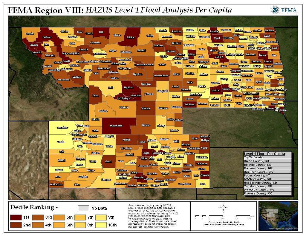
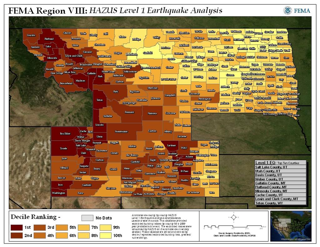
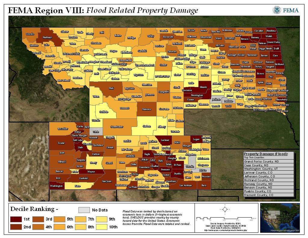
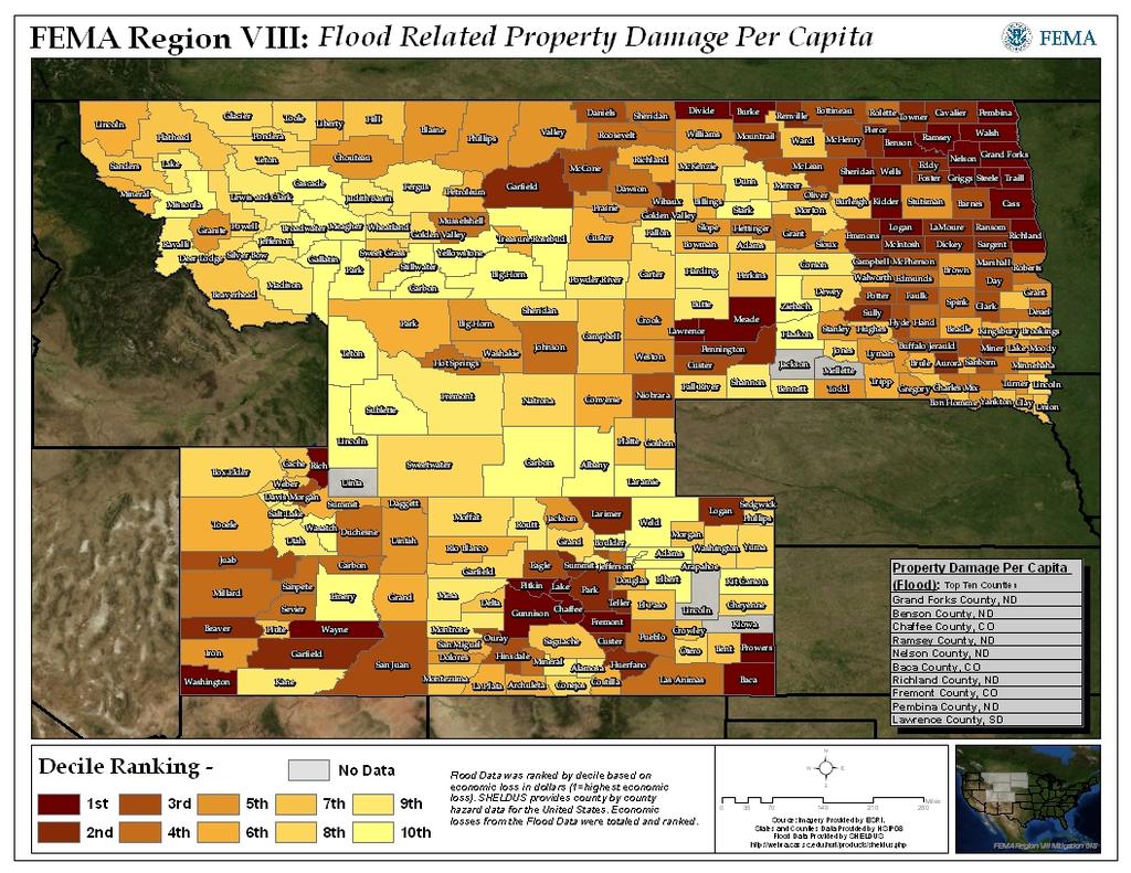
10 HAZUS Level I Applications State Mitigation Plan The out of the box Level I runs may have more application in support of the State-wide mitigation plan than the local plans. This is because they provide an apples-to to-apples comparison of relative losses by jurisdiction (County). We have found it useful to rank the Counties by total loss, as well w as per-capita (divide total $ loss by population) or loss ratio (divide total $ loss by total $ exposure). The latter two provide useful information on high risk rural Counties. In addition, ranking by deciles or groups of high, moderate and low losses may be just as useful in prioritizing jurisdictions by relative risk as a detailed ranking and better reflect the uncertainty inherent in the loss estimates.
11 Local Mitigation Plan Applications The HAZUS Level I runs once imported by a knowledgeable HAZUS user provide the starting point for a particular County, but at least some QA/QC is typically warranted before publishing detailed loss information for a particular jurisdiction. The user should go through a process where the Level 1 flood hazard ard delineation is replaced by available DFIRM data as the DFIRM should be the authoritative product and was based on more extensive analysis. The QA/QC should determine if any of the problem reaches are in areas that can contribute to losses and should be reanalyzed. The reanalysis may be done by running the reaches separately The QA/QC should consist of overlaying the flood polygons on imagery, or other flood and stream data, such as the National Hydrologic Dataset to identify potential erroneous flood hazard polygons. Erroneous errors are frequently related to the DEM being too poor quality to support the analysis. If this is the case, redoing the analyses on 10 meter (1/3 arc second) or better DEM may be warranted. High risk areas where data are available may require a Level II HAZUS analysis that would consist of developing a water depth grid analysis by combining quality DFIRM and high resolution terrain data. In addition, incorporating a site-specific specific or parcel based approach can greatly improve the inventories and loss estimates over the Level I census block approach.

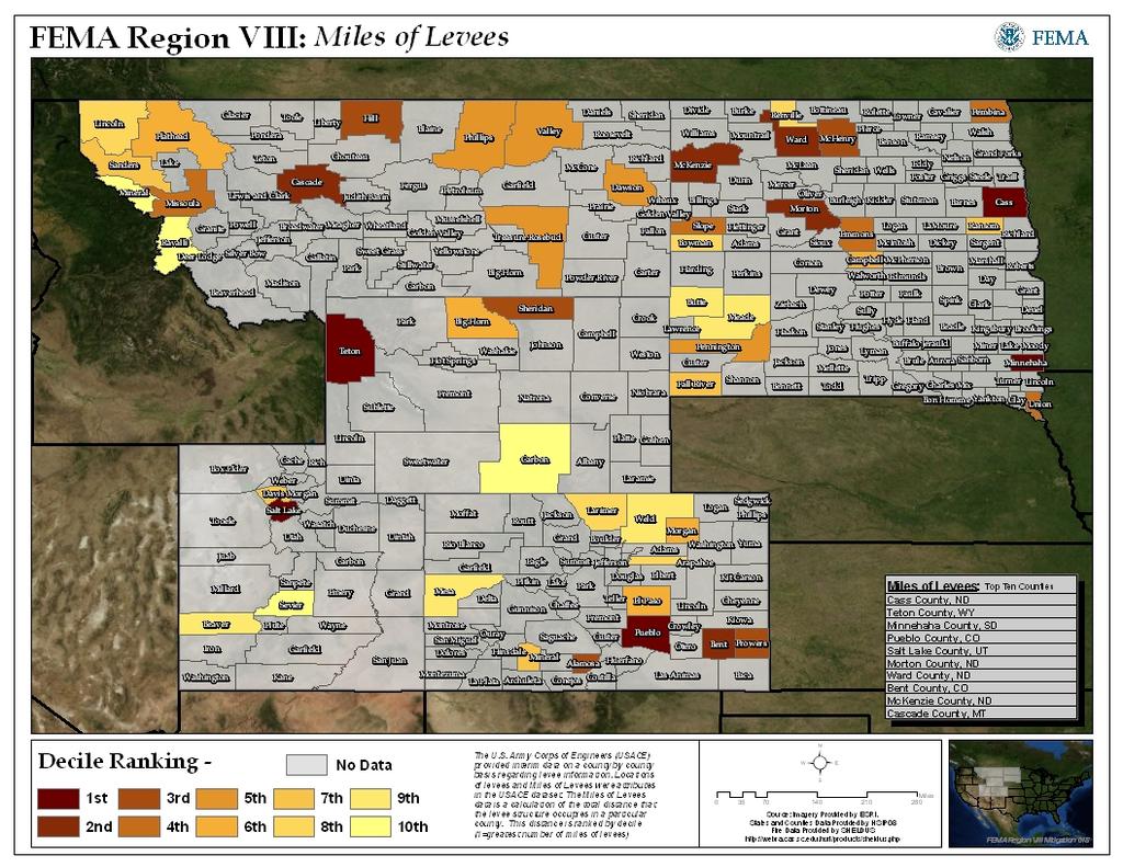
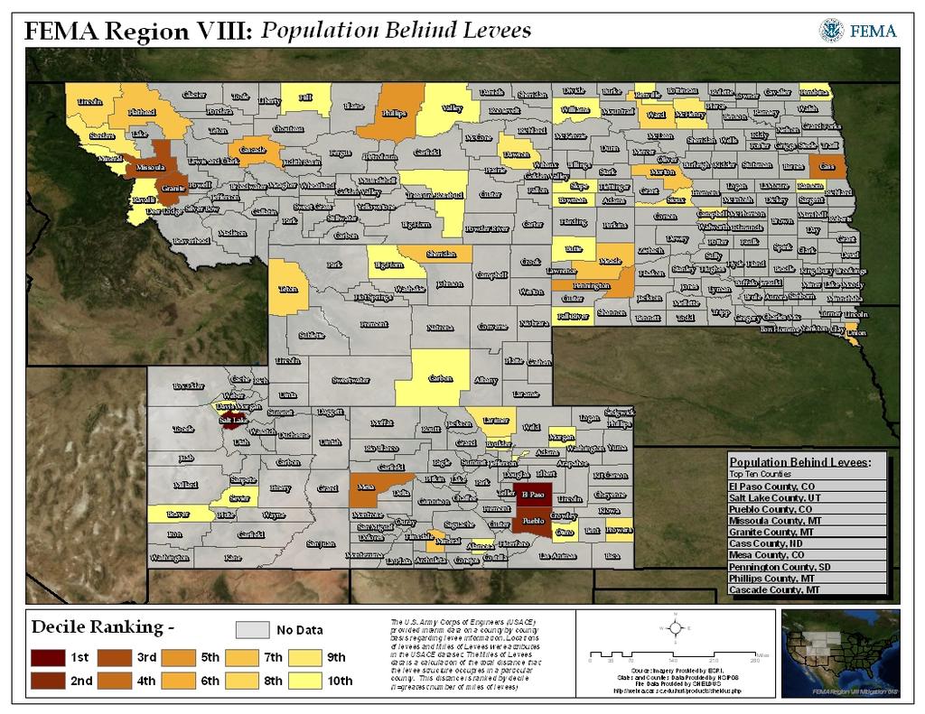
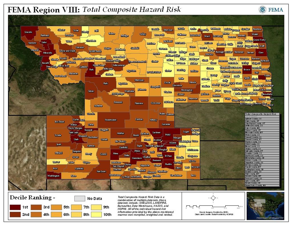
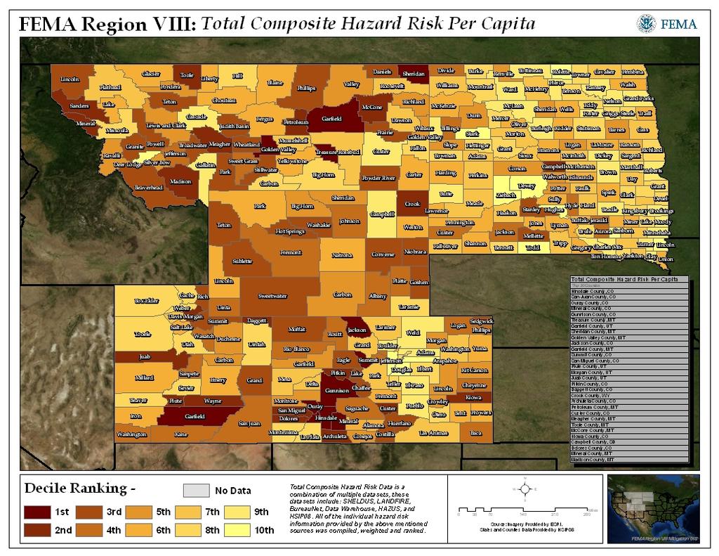
12 Region VIII Vulnerability Index Hazards: Flooding Fire Wildland and Grassland Earthquake Severe Weather Winter Weather Hail Lightning Severe Thunderstorm Tornado Landslide Levees 8 January 2009, Colorado Wildfire, Boulder Huffington Post

13 Vulnerability Index - Methodology: Compilation of national datasets including historical hazard information Incorporation of HAZUS Level I 100 year Flood and Earthquake Average Annualized Losses All data sets were complied into a single data structure and database. Relative ranking of counties by deciles and deciles per capita for each hazard examined. September 1994, Colorado, Mudflow near Glenwood Springs as a result of Storm King Mountain Fire USGS


14 Vulnerability Index - Purpose: Standardized, documented, and actively maintained analysis platform for apples to apples comparison on an intra- and inter- region basis. Method for driving risk based decision making processes. Method for identifying program implementation gaps (areas where high risk is prevalent but planning and mitigation projects are lacking). 1997, North Dakota, Red River Flooding, Grand Forks USGS
 data.")
.")
15 Vulnerability Index Data Structure: All data hosted out of a single geodatabase. Geodatabase includes raw data and final (ranked) data. Ideally maps would be automatically updated with new data through persistent data links to hazard data sources. Not region specific (data structure can be linked to any region). 5 June 2009, Wyoming, La Grange Sideways Tornado
 Earthquake HAZUS (Modeled Analysis) Severe Weather SHELDUS (Historical Analysis) Landslide SHELDUS (Historical Analysis) 2 June 1997, Colorado, Tornado Near Fort")
16 Vulnerability Index Hazard Analysis: Flooding HAZUS (Modeled Analysis), SHELDUS (Historical Analysis) and BureauNet (National Flood Insurance Policy, NFIP, Data) Wildfire LANDFIRE (Modeled Analysis) and SHELDUS (Historical Analysis) Earthquake HAZUS (Modeled Analysis) Severe Weather SHELDUS (Historical Analysis) Landslide SHELDUS (Historical Analysis) 2 June 1997, Colorado, Tornado Near Fort Morgan Levees Army Corp of Engineers
17 Vulnerability Index Data Sources: HAZUS Loss estimation software, Department of Homeland Security (FEMA) SHELDUS Spatial Hazards Events & Losses Database for the United States (University of South Carolina) LANDFIRE Landscape Fire & Resource Management Planning Tools Project (USDA Forest Service & Department of the Interior) HSIP Homeland Security Information Program, Department of Homeland Security (FEMA) BureauNet Department of Homeland Security (FEMA) Data Warehouse Department of Homeland Security (FEMA) USACE United States Army Corps of Engineers FEMA Region VIII Mitigation GIS
18
19
20
21
22
23
24
25
26 Total Composite Hazard Risk *Top 30 Counties Larimer County, CO Utah County, UT Washington County, UT Jefferson County, CO Cass County, ND Weber County, UT Missoula County, MT Pitkin County, CO Summit County, CO Summit County, UT Pueblo County, CO Weld County, CO Mesa County, CO Adams County, CO Salt Lake County, UT Douglas County, CO Gunnison County, CO Minnehaha County, SD Denver County, CO Arapahoe County, CO El Paso County, CO Ravalli County, MT Codington County, SD Boulder County, CO Park County, MT Lincoln County, MT Fremont County, CO Lake County, MT Brown County, SD Grand Forks County, ND Total Composite Hazard Risk Per Capita *Top 30 Counties Hinsdale County, CO San Juan County, CO Ouray County, CO Mineral County, CO Gunnison County, CO Treasure County, MT Garfield County, UT Sheridan County, MT Golden Valley County, MT Jackson County, CO Garfield County, MT Summit County, CO San Miguel County, CO Piute County, UT Morgan County, UT Juab County, UT Pitkin County, CO Daggett County, CO Crook County, WY Archuleta County, CO Petroleum County, MT Custer County, CO Meagher County, MT Toole County, MT McCone County, MT Kiowa County, CO Campbell County, SD Dolores County, CO Mineral County, MT Madison County, MT
27 The End
A summary of regional economic indicators for the state of Colorado
 THE ECONOMIC DATABOOK A summary of regional economic indicators for the state of JULY 24, 217 FEDERAL RESERVE BANK of KANSAS CITY SUMMARY OF CURRENT COLORADO ECONOMIC CONDITIONS In, the unemployment rate
Please be aware that PMD also has two team members to serve as C-Stat performance resources to the counties.
 County C-Stat Arapahoe County March 2015 Dear Human Services Directors, In an effort to improve our services to you, the CDHS Performance Management Division (PMD) will provide you with the County C-Stat
G318 Local Mitigation Planning Workshop. Module 2: Risk Assessment. Visual 2.0
 G318 Local Mitigation Planning Workshop Module 2: Risk Assessment Visual 2.0 Unit 1 Risk Assessment Visual 2.1 Risk Assessment Process that collects information and assigns values to risks to: Identify
Drug Felony Filings Continue to Increase in Colorado, Driving Up State Prison Budget
 Special Report January 3, 219 Continue to Increase in Colorado, Driving Up State Prison Budget With prisons nearly full and the Department of Corrections budget closing in on $1 billion, most Coloradans
Prepared by Miller & Newberg (MN) Consulting Actuaries
 Consulting Actuaries") Prepared by Miller & Newberg (MN) Consulting Actuaries Project Manager: Michael Brown, FSA, MAAA, Managing Director Gene Blobaum, FSA, MAAA, Senior Actuary Spencer Loudon, Actuarial Analyst Introduction
Prepared by Miller & Newberg (MN) Consulting Actuaries Project Manager: Michael Brown, FSA, MAAA, Managing Director Gene Blobaum, FSA, MAAA, Senior Actuary Spencer Loudon, Actuarial Analyst Introduction
Medicare Supplement Outline of Coverage
 Medicare Supplement Outline of Coverage Plans A, F, G & N Anthem Blue Cross and Blue Shield Colorado 2017 This booklet includes premium rates, Medicare deductibles, copays and maximum out-of-pocket costs.
Medicare Supplement Outline of Coverage
 OOC_MS_CO-T_NTM_AOOC001M(Rev 7-16)(09-19-2017)-2019rates 9/19/2018 10:52 AM (BASE/ORIG) Medicare Supplement Outline of Coverage Plans A, F, G & N Anthem Blue Cross and Blue Shield Colorado 2019 This booklet
Leveraging HAZUS for Risk Assessment Analysis within Risk MAP
 Leveraging HAZUS for Risk Assessment Analysis within Risk MAP Jen Meyer - FEMA Region X Shane Parson - RAMPP PTS Team (URS Corp.) 2010 HAZUS Conference - August 2010 The Paradigm Shift: Map Mod to Risk
Adams County. Alamosa County. Arapahoe County. Archuleta County 1A 2017 Sales Tax Increase & Debt Increase. Baca County.
 2017 Ballot Issues (Unofficial Results) Spending Waiver Adams Alamosa Arapahoe Archuleta & 1% sales tax increase beginning January 1, 2018 and terminating on December 31, 2032 to pay off sales tax revenue
Flood Risk Assessment in the
 Georgia Flood M.A.P. Program Flood Risk Assessment in the Upper Chattahoochee h h River Basin GAFM Annual Conference March 28, 2012 Agenda Map Mod to Risk MAP (Georgia Flood M.A.P.) transition Flood Risk
ECONOMIC CONTRIBUTIONS OF COLORADO S NONPROFIT SECTOR
 ECONOMIC CONTRIBUTIONS OF COLORADO S NONPROFIT SECTOR E x e c u t i v e S u m m a r y This economic impact study is a component of a larger effort to demonstrate the contributions that the nonprofit sector
COLORADO INDIGENT CARE PROGRAM
 COLORADO INDIGENT CARE PROGRAM FISCAL YEAR 2009 MANUAL SECTION II: DATA COLLECTION EFFECTIVE: JULY 1, 2008 TABLE OF CONTENTS ARTICLE I. PROGRAM OVERVIEW 1 Section 1.01 Program Definition 1 Section 1.02
NORTH CENTRAL COLORADO
 DOLA Planning and Management Region 2 Socioeconomic Profile Regional Profile NORTH CENTRAL COLORADO The central work of the State Demography Office is the research and production of population data and
ANNEX B: TOWN OF BLUE RIVER
 ANNEX B: TOWN OF BLUE RIVER B.1 Community Profile Figure B.1 shows a map of the Town of Blue River and its location within Summit County. Figure B.1. Map of Blue River Summit County (Blue River) Annex
Mapping Flood Risk in the Upper Fox River Basin:
 Mapping Flood Risk in the Upper Fox River Basin: Vulnerable Populations and Adverse Health Effects Presented by: Angelina Hanson STUDY AREA: Wisconsin's Upper Fox River Basin Total Population 139,309.
Discovery Report. Cache River Watershed, Alexander, Johnson, Pulaski, and Union Counties, Illinois
 Discovery Report Cache River Watershed, 07140108 Alexander, Johnson, Pulaski, and Union Counties, Illinois 12/21/2012 i Project Area Community List Community Name Alexander County Village of Tamms Johnson
9.10 HEIDELBERG TOWNSHIP
 9.10 HEIDELBERG TOWNSHIP This section presents the jurisdictional annex for Heidelberg Township. A. HAZARD MITIGATION PLAN POINT OF CONTACT Name Title/ Department Address Telephone Fax Email Primary Point
Overview of Capabilities and Current Limitations
 Overview of Capabilities and Current Limitations Overview of the National Flood Risk Characterization Tool (NFRCT) Map based viewer of relative flood risk around the U.S., with supporting reports for more
VULNERABILITY ASSESSMENT
 SOUTHSIDE HAMPTON ROADS HAZARD MITIGATION PLAN VULNERABILITY ASSESSMENT INTRODUCTION The Vulnerability Assessment section builds upon the information provided in the Hazard Identification and Analysis
INDIVIDUAL SILVER COST-SHARE REDUCTION PLANS. Benefits Summary
 2019 INDIVIDUAL SILVER COST-SHARE REDUCTION PLANS Benefits Summary Friday Health Plans Coverage Map Counties Served by Region Denver Metro Adams Arapahoe Broomfield Boulder Denver Douglas Elbert Jefferson
The Economic Impact of Department of Defense, Veterans and Military Retirees, and the Department of Veterans Affairs Activities in Colorado
 The Economic Impact of Department of Defense, Veterans and Military Retirees, and the Department of Veterans Affairs Activities in Colorado By Summit Economics, LLC Paul Rochette, Senior Partner, Principle
SMALL GROUP HEALTH PLANS. Benefits Summary
 2019 SMALL GROUP HEALTH PLANS Benefits Summary Friday Health Plans Group Coverage Map Counties Served by Region Denver Metro Adams Arapahoe Broomfield Boulder Denver Douglas Elbert Jefferson Grand Junction
Monthly Rates. Plans A, F, High Deductible Plan F, G & N Effective January 1, 2012
 Administrative Office: PO Box 906, Oxnard, CA 90-906 Toll Free Telephone Number: -877-8-000 Effective January, 0 Premium Information We, Anthem, can only raise your premium if we raise the premium for
INDIVIDUAL HEALTH PLANS. Benefits Summary
 2019 INDIVIDUAL HEALTH PLANS Benefits Summary Friday Health Plans Coverage Map Counties Served by Region Denver Metro Adams Arapahoe Broomfield Boulder Denver Douglas Elbert Jefferson Grand Junction Mesa
Fiscal Year Every Student Succeeds Act of 2015
 Fiscal Year 2018-19 Every Succeeds Act of 2015 Title II - A 0010 Adams Mapleton 1 $1,162,304 $192,593 $180,836 $0 $73,604 $0 $1,609,337 0020 Adams Northglenn-Thornton 12 $4,483,355 $858,128 $494,637 $13,946
ASFPM Partnerships for Statewide Mitigation Actions. Alicia Williams GIS and HMP Section Manager, Amec Foster Wheeler June 2016
 ASFPM Partnerships for Statewide Mitigation Actions Alicia Williams GIS and HMP Section Manager, Amec Foster Wheeler June 2016 Summary The Concept Leveraging Existing Data and Partnerships to reduce risk
FYI For Your Information
 TAXPAYER SERVICE DIVISION FYI For Your Information Research and Development Income Tax Credit for Enterprise Zones Taxpayers who make expenditures on research and experimental activities in an enterprise
9.2 ALBURTIS BOROUGH. This section presents the jurisdictional annex for Alburtis Borough. A. HAZARD MITIGATION PLAN POINT OF CONTACT
 9.2 ALBURTIS BOROUGH This section presents the jurisdictional annex for Alburtis Borough. A. HAZARD MITIGATION PLAN POINT OF CONTACT Name Title/ Department Address Telephone Fax Email Primary Point of
THE SELF-SUFFICIENCY STANDARD FOR COLORADO Prepared for Colorado Center on Law and Policy
 THE SELF-SUFFICIENCY STANDARD FOR COLORADO 2018 Prepared for Colorado Center on Law and Policy Colorado Center on Law and Policy Colorado s legal aid community created CCLP in 1998, so that people would
Comparing HAZUS Flood Loss Estimates Across Hazard Identification Methods and Building Stock Inventory Data. Albion Township Dane County, Wisconsin
 Across Hazard Identification Methods and Building Stock Inventory Data Albion Township Dane County, Wisconsin Prepared for the Association of State Floodplain Managers September 1, 2010 Across Various
Source: FEMA, Local Hazard Mitigation Handbook (2013) fema.gov/media-library-data/ /fema_local_mitigation_handbook.
 fema.gov/media-library-data/ /fema_local_mitigation_handbook.") Developing strategies and implementation tools for mitigating hazards first requires an evaluation of a community s risk and vulnerability to particular hazards. This chapter provides information on the
Developing strategies and implementation tools for mitigating hazards first requires an evaluation of a community s risk and vulnerability to particular hazards. This chapter provides information on the
Economic Contribution of Off-Highway Vehicle Recreation in Colorado Season. A joint cooperation report
 Recreation in Colorado 2014-2015 Season A joint cooperation report December 6, 2016 Recreation in Colorado Prepared For: Colorado Off-Highway Vehicle Coalition P.O. Box 741353 Arvada, Colorado 80006 Prepared
provided to months. or essential not change substantially
 Coloradoo Department of Humann Services Indirect Cost FAQ These answers have been provided to various stakeholders (e.g. counties, Joint Budget Committee, Joint Budget Committee Staff ) over the past few
Findings/Debrief Meeting September 9, CDOT R4 Headquarters Big Thompson Conference Room W 10 th St. Greeley, CO 80634
 Findings/Debrief Meeting September 9, 2016 CDOT R4 Headquarters Big Thompson Conference Room 10601 W 10 th St. Greeley, CO 80634 Discovery Review & Outcome May 25 Discovery Meeting Summary Summarize Data
POPULATION AND ECONOMIC OVERVIEW. State Demography Office Colorado Department of Local Affairs February 2014
 POPULATION AND ECONOMIC OVERVIEW State Demography Office Colorado Department of Local Affairs February 2014 Big Picture 2011-2012 Pop Change US 313 million, + 2.3 million or.7% Colorado 5,189,458, + 70,157
Michael Taylor, PE, CFM Project Manager, AECOM August 25, 2015
 Promoting FEMA s Flood Risk Products in the Lower Levisa Watershed Michael Taylor, PE, CFM Project Manager, AECOM August 25, 2015 Agenda Study Background Flood Risk Product Overview AOMI and Mitigation
COLORADO PERA ECONOMIC AND FISCAL IMPACTS
 COLORADO PERA ECONOMIC AND FISCAL IMPACTS Knowles Gallery/iStock/Thinkstock Prepared by PACEY ECONOMICS, INC. December 2018 CONTENTS 01 Executive Summary 03 Colorado PERA Background 04 PERA and Perspective
Kentucky Risk MAP It s not Map Mod II
 Kentucky Risk MAP It s not Map Mod II Risk Mapping Assessment and Planning Carey Johnson Kentucky Division of Water carey.johnson@ky.gov What is Risk MAP? Risk Mapping, Assessment, and Planning (Risk MAP)
Name Title/ Department Address Telephone Fax
 9.14 LYNN TOWNSHIP This section presents the jurisdictional annex for Lynn Township. A. HAZARD MITIGATION PLAN POINT OF CONTACT Name Title Address Telephone Fax Email Primary Point of Contact Janet Henritzy
Town of Montrose Annex
 Town of Montrose Annex Community Profile The Town of Montrose is located in the Southwest quadrant of the County, east of the Town of Primrose, south of the Town of Verona, and west of the Town of Oregon.
Garfield County NHMP:
 Garfield County NHMP: Introduction and Summary Hazard Identification and Risk Assessment DRAFT AUG2010 Risk assessments provide information about the geographic areas where the hazards may occur, the value
Association of State FloodPlain Managers 2809 Fish Hatchery Road, Madison, WI Phone: Fax:
 Association of State FloodPlain Managers 2809 Fish Hatchery Road, Madison, WI 53713 Phone: 608-274-0123 Fax: 274-0696 Website: www.floods.org Email: asfpm@floods.org Conference Call: FEMA-Washington and
BUTTS COUNTY, GEORGIA AND INCORPORATED AREAS
 BUTTS COUNTY, GEORGIA AND INCORPORATED AREAS Butts County Community Name Community Number BUTTS COUNTY (UNICORPORATED AREAS) 130518 FLOVILLA, CITY OF 130283 JACKSON, CITY OF 130222 JENKINSBURG, TOWN OF
Fiscal Year No Child Left Behind Act of 2001
 Fiscal Year 2014-15 No Child Left Behind Act of 2001 0010 Adams Mapleton 1 $1,213,143 $181,541 $149,680 $0 $0 $1,544,364 0020 Adams Northglenn-Thornton 12 $4,723,447 $712,570 $419,358 $53,501 $0 $5,908,877
General Decision Number: CO /26/2013 CO13. Superseded General Decision Number: CO State: Colorado. Construction Type: Heavy
 General Decision Number: CO130013 07/26/2013 CO13 Superseded General Decision Number: CO20120013 State: Colorado Construction Type: Heavy Counties: Alamosa, Archuleta, Baca, Bent, Chaffee, Cheyenne, Clear
Fiscal Year No Child Left Behind Act of 2001
 Fiscal Year 2016-17 No Child Left Behind Act of 2001 0010 Adams Mapleton 1 $1,104,243 $173,136 $163,644 $20,368 $0 $1,461,391 0020 Adams Northglenn-Thornton 12 $4,300,395 $682,600 $469,667 $0 $0 $5,452,662
Village of Blue Mounds Annex
 Village of Blue Mounds Annex Community Profile The Village of Blue Mounds is located in the southwest quadrant of the County, north of the town of Perry, west of the town of Springdale, and south of the
Wildfire and Flood Hazards, Using GIS Tools to Assess Risk
 Wildfire and Flood Hazards, Using GIS Tools to Assess Risk Floodplain Management Association Conference, Rancho Mirage, CA September 2015 Thoughts To Keep In Mind What advantages are there in looking at
TABLE OF CONTENTS. Foreword... i. Executive Summary...1. Prerequisites... P.1. Participating Jurisdictions... P.1. Participation Requirements... P.
 TABLE OF CONTENTS Foreword... i Executive Summary...1 Prerequisites... P.1 Participating Jurisdictions... P.1 Participation Requirements... P.2 Record of Participation... P.3 Sample Adoption Resolution...
NCLB Revised Final Allocations Fiscal Year No Child Left Behind Act of 2001
 NCLB Revised Final Allocations Fiscal Year 2016-17 No Child Left Behind Act of 2001 CODE COUNTY RICT TITLE I TITLE II 0010 Adams Mapleton 1 $1,108,927 $173,992 $163,644 $20,368 $0 $1,466,931 0020 Adams
TREASURER & PUBLIC TRUSTEE QUADRENNIAL. February 14, 15, 16, 2011
 TREASURER & PUBLIC TRUSTEE QUADRENNIAL February 14, 15, 16, 2011 2011 CCTA/CTPA Quadrennial February 14, 15 and 16 Southwest Weld Office 4209 WCR 24 ½, Longmont Hosted by Weld County Treasurer s Office
GIS - Introduction and Sample Uses
 PDHonline Course L145 (5 PDH) GIS - Introduction and Sample Uses Instructor: Jonathan Terry, P.L.S. 2012 PDH Online PDH Center 5272 Meadow Estates Drive Fairfax, VA 22030-6658 Phone & Fax: 703-988-0088
SECTION 6 VULNERABILITY ASSESSMENT
 SECTION 6 VULNERABILITY ASSESSMENT This section identifies and quantifies the vulnerability of the MEMA District 6 Region to the significant hazards identified in the previous sections (Hazard Identification
Name Title/ Department Address Telephone Fax
 9.36 FORKS TOWNSHIP This section presents the jurisdictional annex for Forks Township. A. HAZARD MITIGATION PLAN POINT OF CONTACT Primary Point of Contact Name Title/ Department Address Telephone Fax Email
in coordination with Peoria County, Planning and Zoning Department
 Prepared by Amec Foster Wheeler Environment & Infrastructure Hazard Mitigation and Emergency Management Program in coordination with Peoria County, Planning and Zoning Department The purpose of hazard
Use of FEMA Non regulatory Flood Risk Products in Planning
 Use of FEMA Non regulatory Flood Risk Products in Planning Georgia Association of Floodplain Managers Annual Conference March 24, 2016 What are the Non regulatory Flood Risk products? Go beyond the basic
RichSmith_slate-FEMA_320x240.wmv.
 Nebraska DNR s role in the making of FEMA s Digital Flood Insurance Rate Maps Becky Groshens (grow-hands) & Shelley Schindler Important Terms: FIRM: Flood Insurance Rate Map FIS: Flood Insurance Study
CRISP COUNTY, GEORGIA AND INCORPORATED AREAS
 CRISP COUNTY, GEORGIA AND INCORPORATED AREAS Community Name Community Number ARABI, CITY OF 130514 CORDELE, CITY OF 130214 CRISP COUNTY (UNINCORPORATED AREAS) 130504 Crisp County EFFECTIVE: SEPTEMBER 25,
9.8 FOUNTAIN HILL BOROUGH
 9.8 FOUNTAIN HILL BOROUGH This section presents the jurisdictional annex for Fountain Hill Borough. A. HAZARD MITIGATION PLAN POINT OF CONTACT Name Title/ Department Address Telephone Fax Email Primary
Integrating Hazus into the Flood Risk Assessment
 Integrating Hazus into the Flood Risk Assessment GAFM Conference, March 22, 2016 Mapping Assessment Planning Agenda What is Hazus & Risk Assessment? Census Block vs. Site Specific Analysis User Defined
RISK MANAGEMENT NEXT GENERATION
 RISK MANAGEMENT NEXT GENERATION STATE UPDATE July 2014 Marc Stanard / John Dorman Risk Management Key Components and National Status Risk Monitoring No digital tracking Big Elephant to Track Not Tied to
Senior Tax Deferral. Property must be owner-occupied Must own or be buying the property. Total amount owed must be less than 75% of value
 Senior Programs Senior Tax Deferral Senior Tax Deferral A State program 39-3.5-102 C.R.S. (1) (a) Subject to the provisions of this article, a person who is sixty-five years of age or older or who is a
COMMUNITY SUMMARY LINN COUNTY MULTI-JURISDICTIONAL HAZARD MITIGATION PLAN CITY OF LISBON
 COMMUNITY SUMMARY LINN COUNTY MULTI-JURISDICTIONAL HAZARD MITIGATION PLAN CITY OF LISBON This document provides a summary of the hazard mitigation planning information for the City of Lisbon that will
APPENDIX A: REFERENCES
 APPENDIX A: REFERENCES 2002 Census of Agriculture. http://www.agcensus.usda.gov/ 2007 Kansas Severe Weather Awareness Week Information Packet. National Weather Service. 2007. www.crh.noaa.gov/image/top2007kansas.pdf
At this time an understanding of flood damages
 20 Cartwright UNIVERSITIES COUNCIL ON WATER RESOURCES ISSUE 130, PAGES 20-25, MARCH 2005 An Examination of Flood Damage Data Trends in the United States Lauren Cartwright U.S. Army Corps of Engineers Institute
Wyoming s Five-Year Floodplain Management Work Plan
 Wyoming s Five-Year Floodplain Management Work Plan Purpose: The purpose of this work plan is for the benefit of the Wyoming communities so that the risk and damages are minimized and environmental values
9.46 NAZARETH BOROUGH
 9.46 NAZARETH BOROUGH This section presents the jurisdictional annex for Nazareth Borough. A. HAZARD MITIGATION PLAN POINT OF CONTACT Name Title/ Department Address Telephone Fax Email Primary Point of
5.3 HAZARD RANKING HAZARD RANKING METHODOLOGY
 5.3 HAZARD RANKING After the hazards of concern were identified for Burlington County, the hazards were ranked to describe their probability of occurrence and their impact on population, property (general
Overview of HAZUS. December 6, 2011
 Overview of HAZUS December 6, 2011 What is HAZUS? Risk assessment tool for analyzing potential losses from hurricane, flood, and earthquake Uses current scientific and engineering concepts in a GIS to
Northern Kentucky University 2018 Hazard Mitigation Plan. Public Kick-Off Meeting March 20, 2018
 Northern Kentucky University 2018 Hazard Mitigation Plan Public Kick-Off Meeting March 20, 2018 Agenda Welcome Hazard Mitigation Planning 101 Hazard Identification Exercises Next Steps Jeff Baker, NKU
COLORADO EMPLOYMENT AND WAGES
 COLORADO EMPLOYMENT AND WAGES ANNUAL 2000 STATE OF COLORADO BILL OWENS, GOVERNOR DEPARTMENT OF LABOR & EMPLOYMENT VICKIE ARMSTRONG, EXECUTIVE DIRECTOR DIVISION OF EMPLOYMENT & TRAINING LABOR MARKET INFORMATION
Colorado Economic Chronicle
 Colorado Economic Chronicle!!"# Mike Mauer Chief Economist Marie Garcia Staff Assistant The Legislative Council is the research arm of the Colorado General Assembly. The Council provides nonpartisan information
HAZUS -MH Risk Assessment and User Group Series HAZUS-MH and DMA Pilot Project Portland, Oregon. March 2004 FEMA FEMA 436
 HAZUS -MH Risk Assessment and User Group Series HAZUS-MH and DMA 2000 Pilot Project Portland, Oregon March 2004 FEMA FEMA 436 Page intentionally left blank. Risk Assessment Pilot Project Results for DMA
DeSoto Parish Hazard Mitigation Plan Update Kick-off Meeting. February 16, 2016 Grand Cane, LA
 DeSoto Parish Hazard Mitigation Plan Update Kick-off Meeting February 16, 2016 Grand Cane, LA Introductions Officials Mitigation Steering Committee members SDMI team members GOHSEP hazard mitigation team
September Three Steps for Implementing a Complete Flood Management Plan
 September 2016 Three Steps for Implementing a Complete Flood Management Plan Copyright 2016 Esri All rights reserved. Printed in the United States of America. The information contained in this document
Colorado Division of Child Support Services
 EMPLOYER S GUIDE TO INCOME WITHHOLDING FOR CHILD SUPPORT, Editor Published 1988 Revised, 2008, 2011, 2012, 2013 Colorado Division of Child Support Services 1575 Sherman Street Denver, Colorado 80203 Paulette
FEMA s Flood Map Modernization Preparing for FY09 and Beyond: Integrated Flood Data Update, Risk Assessment, and Mitigation Planning
 FEMA s Flood Map Modernization Preparing for FY09 and Beyond: Integrated Flood Data Update, Risk Assessment, and Mitigation Planning DRAFT CONCEPT PAPER June 1, 2007 Integrated Flood Data Update, Risk
NFIP Program Basics. KAMM Regional Training
 NFIP Program Basics KAMM Regional Training Floodplain 101 Homeowners insurance does not cover flood damage Approximately 25,000 flood insurance policies in KY According to BW12 analysis, approximately
Non Regulatory Risk MAP Products Flood Depth and Probability Grids
 Non Regulatory Risk MAP Products Flood Depth and Probability Grids Virginia Floodplain Management Association 2015 Floodplain Management Workshop October 29th, 2015 Nabil Ghalayini, P.E., PMP, D.WRE, CFM
CHAPTER 1 INTRODUCTION
 CHAPTER 1 INTRODUCTION Many disaster losses rather than stemming from unexpected events are the predictable result of interactions among three major systems: the physical environment, which includes hazardous
GIS - Introduction and Sample Uses
 PDHonline Course L145 (5 PDH) GIS - Introduction and Sample Uses Instructor: Jonathan Terry, P.L.S. 2012 PDH Online PDH Center 5272 Meadow Estates Drive Fairfax, VA 22030-6658 Phone & Fax: 703-988-0088
COMMUNITY SUMMARY LINN COUNTY MULTI-JURISDICTIONAL HAZARD MITIGATION PLAN CITY OF CENTRAL CITY
 COMMUNITY SUMMARY LINN COUNTY MULTI-JURISDICTIONAL HAZARD MITIGATION PLAN CITY OF CENTRAL CITY This document provides a summary of the hazard mitigation planning information for the City of Central City
Cabin Insurers by County
 Cabin Insurers by County National Forest Homeowners, January, 2017 State County Insurer Total AK Venneberg 1 AK Total 1 AR Lee Arkansas Farm Bureau Insurance 1 AR Lee State Farm Insurance 1 AR Total 2
Georgia Silver Jackets Team
 Georgia Silver Jackets Team 9 th Annual GAFM Technical Conference Jeff Morris GA SJ Collaborator Savannah District, USACE US Army Corps of Engineers SMART GOVERNMENT Integrate and synchronize flood risk
9.24 WEISENBERG TOWNSHIP
 9.24 WEISENBERG TOWNSHIP This section presents the jurisdictional annex for Weisenberg Township. A. HAZARD MITIGATION PLAN POINT OF CONTACT Name Title/ Department Address Telephone Fax Email Primary Point
APPENDIX D PLANNING PROCESS DOCUMENTATION
 APPENDIX D PLANNING PROCESS DOCUMENTATION This appendix includes the following: 1. Meeting Agendas 2. Meeting Minutes 3. Meeting Sign-In Sheets 4. Public Survey Summary Results 1) Introductions AGENDA
SECTION 1 INTRODUCTION
 SECTION 1 INTRODUCTION This section provides a general introduction to the Mississippi Emergency Management Agency (MEMA) District 9 Regional Hazard Mitigation Plan. It consists of the following five subsections:
Using GISWeb to Determine Your Property s Flood Zone
 Using GISWeb to Determine Your Property s Flood Zone 1. In a new browser window, go to http://www.co.santacruz.ca.us/departments/geographicinformationsystemsgis.aspx 2. Click on GISWeb - GIS Mapping Application
University Drive Flood Risk Management Project Phase I 58 th Ave S to 500 S of 64 th Ave S City of Fargo Project FM-15-C1
 University Drive Flood Risk Management Project Phase I 58 th Ave S to 500 S of 64 th Ave S City of Fargo Project FM-15-C1 Public Informational Meeting October 15, 2015 6:00 P.M. Overview Flood Risk FEMA
A.) HAZARD MITIGATION PLAN POINT OF CONTACT
 HAZARD MITIGATION PLAN POINT OF CONTACT") 9.6 TOWN OF CLAY This section presents the jurisdictional annex for the Town of Clay. A.) HAZARD MITIGATION PLAN POINT OF CONTACT Primary Point of Contact Mark Territo, Commissioner of Planning & Development
9.6 TOWN OF CLAY This section presents the jurisdictional annex for the Town of Clay. A.) HAZARD MITIGATION PLAN POINT OF CONTACT Primary Point of Contact Mark Territo, Commissioner of Planning & Development
Source: NOAA 2011 NATURAL CATASTROPHE YEAR IN REVIEW
 Source: NOAA 2011 NATURAL CATASTROPHE YEAR IN REVIEW January 4, 4 2012 U.S. NATURAL CATASTROPHE UPDATE Carl Hedde, SVP, Head of Risk Accumulation Munich Reinsurance America, Inc. MR NatCatSERVICE One of
9.36 TOWN OF VAN BUREN
 9.36 TOWN OF VAN BUREN This section presents the jurisdictional annex for the Town of Van Buren. A.) HAZARD MITIGATION PLAN POINT OF CONTACT Primary Point of Contact David J. Pringle, Code Enforcement
2015 Mobile County, Alabama Multi-Hazard Mitigation Plan Appendices
 2015 Mobile County, Alabama Multi-Hazard Mitigation Plan A - Federal Requirements for local Mitigation Plans B - Community Mitigation Capabilities C - 2009 Plan Implementation Status D - Hazard Ratings
PARK COUNTY, WYOMING AND INCORPORATED AREAS
 PARK COUNTY, WYOMING AND INCORPORATED AREAS Community Name Community Number CODY, CITY OF 560038 MEETEETSE, TOWN OF 560039 PARK COUNTY UNINCORPORATED AREAS 560085 POWELL, CITY OF 560040 June 18, 2010 Federal
This survey is expected to take approximately 20 minutes and must be completed in one session.
 State Flood Assessment Survey 1 Introduction Thank you for your willingness to participate in this online survey as part of the State Flood Assessment effort. This first step toward developing comprehensive
Uinta Basin Energy Summit Economic Overview September 10, 2015
 Uinta Basin Energy Summit Economic Overview September 10, 2015 Overview National Economic Conditions Utah Economic Conditions Utah is One of the Fastest Growing CA States in the Country Percent Change
CNMS and FOA: A Year in Review. Rick Sacbibit, P.E. Andy Read, CFM FEMA HQ, Risk Analysis Division June 4, 2015
 CNMS and FOA: A Year in Review Rick Sacbibit, P.E. Andy Read, CFM FEMA HQ, Risk Analysis Division June 4, 2015 Overview Current NVUE Status NVUE Cliff Update on CNMS Web Viewer CNMS Guidance Updates FOA
Appendix F: Ozark special Road District Addendum
 Appendix F: Ozark special Road District Addendum F-1: Introduction and Planning Process F-1.1 Purpose The Christian County 2016 Multi-Jurisdictional Natural Hazards Mitigation Plan is an updated version
This survey is expected to take approximately 20 minutes and must be completed in one session.
 Introduction Thank you for your willingness to participate in this online survey as part of the State Flood Assessment effort. This first step toward developing comprehensive flood planning for Texas does
3D Elevation Program (3DEP) Status and Plans. Kevin T. Gallagher Associate Director, Core Science Systems June 26, 2017
 Status and Plans. Kevin T. Gallagher Associate Director, Core Science Systems June 26, 2017") + 3D Elevation Program (3DEP) Status and Plans Kevin T. Gallagher Associate Director, Core Science Systems June 26, 2017 + 2 3D Elevation Program (3DEP) Apply lidar technology to map bare earth and 3D
+ 3D Elevation Program (3DEP) Status and Plans Kevin T. Gallagher Associate Director, Core Science Systems June 26, 2017 + 2 3D Elevation Program (3DEP) Apply lidar technology to map bare earth and 3D