RISK MANAGEMENT NEXT GENERATION
|
|
|
- Jessie Bishop
- 5 years ago
- Views:
Transcription

1 RISK MANAGEMENT NEXT GENERATION STATE UPDATE July 2014 Marc Stanard / John Dorman

2 Risk Management Key Components and National Status Risk Monitoring No digital tracking Big Elephant to Track Not Tied to Other Processes Risk Mitigation Not integrated with Hazard Identification or Risk Assessment Focus is on Compliance No Prioritization Methodology in Place Hardcopy / No Versioning Risk Management Hazard Identification Low Resolution Mapping Lack holistic Mapping of Hazards No Methodologies / Models Risk Assessment Lack Vulnerability Data Low Resolution Impact Models No Interdependency Failure Modeling No Risk Assessment Products for Decision Makers (Financial)


3 Integrated Hazard Risk Management - Concept Hazard Data 1. Hazard Identification 4. Communication 3. Risk Assessment Vulnerabilities 2. Vulnerable Systems 5. Mitigation


4 NC Progression To Integrated Hazard Risk Management Framework and Lifecycle Framework Data Acquisition Flood Hazard Mapping Digital Display Environment Exposure Identification Structural Flood Risk Management Integrated Hazard Risk Management

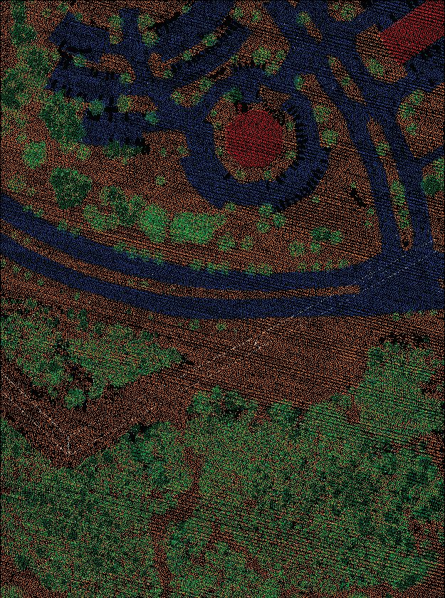
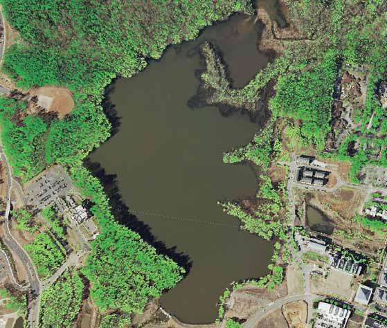
5 LiDAR-Derived Digital Elevation Model (circa )
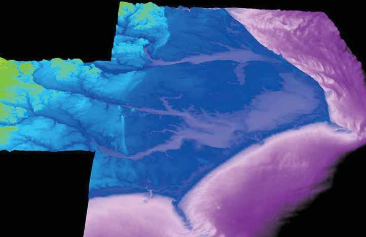
6 Digital Topographic-bathymetric Model

7 QL2 Topo Statewide Acquisition Plan QL2 Statewide Plan 5 Phases / 4 Year Phase 1- USGS and Phase 2- NC are both acquired in 2014 With the financial partnering by USDA NRCS, Phase I added Onslow County. Therefore moving the NC collection Phase 2 to add Robeson County
.")
8 Remote Sensing: LiDAR Technology LiDAR, a Remote Sensing Technology similar to SONAR and RADAR, was used by NC to support Generation 1 of Flood Hazard Mapping in NC. Acquired in three Phases: 2000; 2003; Nominal Point Spacing of 10 feet (3 meter). Accuracy requirement of 20 cm RMSE in the coastal area; 25 cm RMSE for the remainder of the state.

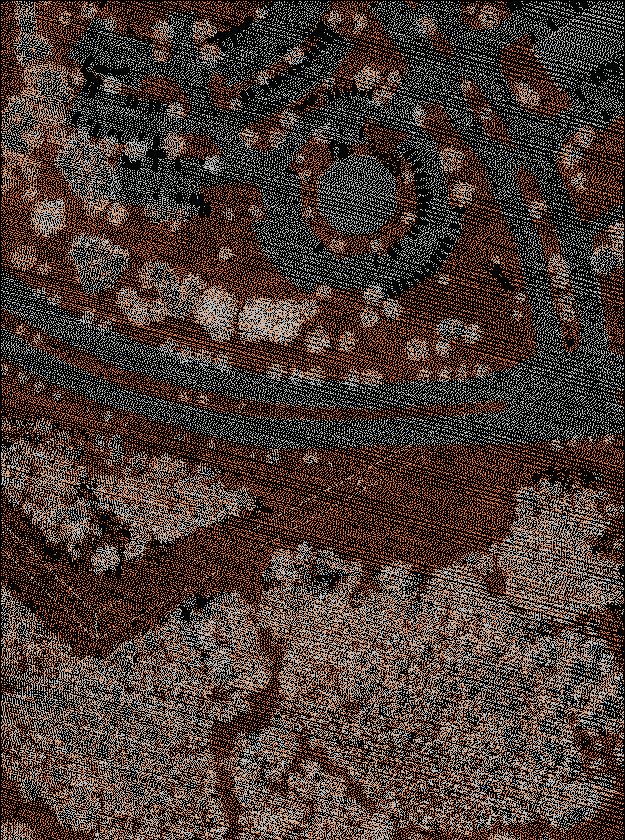
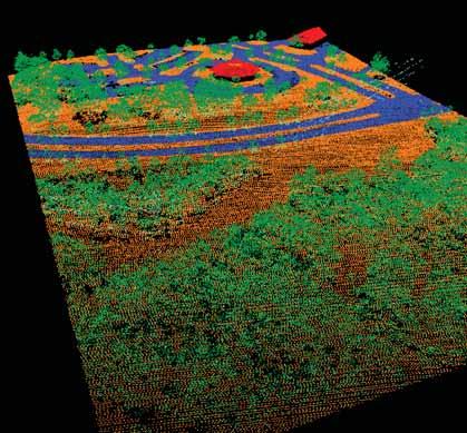
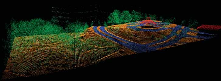
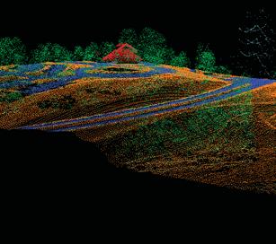
9 LiDAR-Derived Elevation Classification Un-Classified Data Ground/Bare Earth Vegetation Buildings Roads/Impervious
10
11 QL2 Topo Point Summary LIDAR Quality Ground Points in 5 Acre Parcel 30m NED 32 10m NED 300 4m (circa 2003) 7,696 QL2 76,957 *QL2 is a 1,000% increase in analysis points
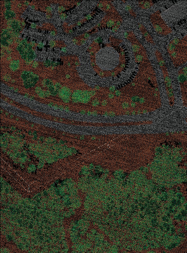
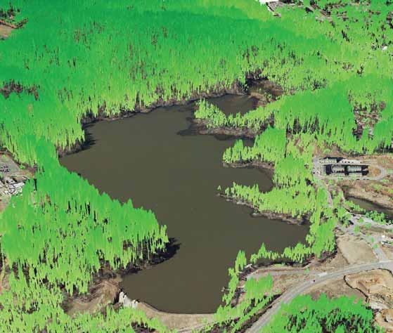
12 Vegetation Detection

13 Low Shrubs

14 Medium Bushes/small trees

15 High Large trees
16 Total Canopy Detection

17 3D Volume of Vegetation

18 30 Meter Elevation Model
19 10 Meter Elevation Model
20 3 Meter Elevation Model (2003 NC LiDAR)

21 QL2 Elevation Model


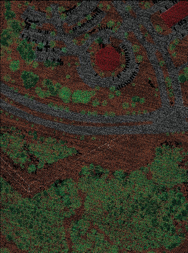
22 QL2 - Building Footprint Extraction and Updates Buildings are classified within the LiDAR point cloud Algorithm looks for planar surfaces with steep edges

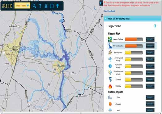
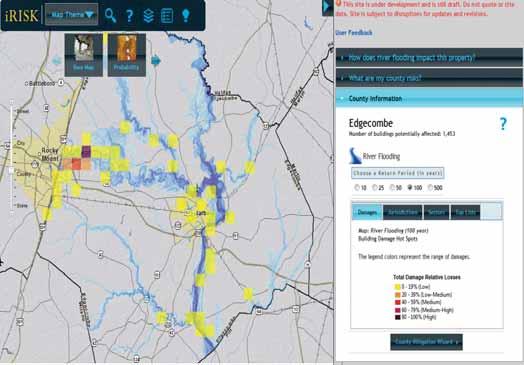
23 QL2 Topo - RGB Composite 3D Fly through Movie *Play NC_QL2_LiDAR.mp4 outside of PowerPoint
24 ACQUISITION / GENERATION Natural Hazards GTMO has acquired all hazard data available to display at different magnitude levels / annual frequency on the parcel, statewide, and national level for: Riverine flooding Dam failure probability Levee failure - probability Coastal flooding Storm surge from hurricanes - Coastal erosion long term damage curve methodology Landslides hazard raster / damage methodology Earthquakes Wind (straight line and hurricane) Tornadoes new HAZUS methodology Wildfire damage methodology Snow/Ice failure threshold / damage methodology Hail - failure threshold / damage methodology Drought hazard raster / damage curves Sea Level Rise - probability


25 Engineering TSDN Transition from Cartographic To Digital, Database Display D 2 E Database


26 Engineering TSDN Floodway Data Flood Profiles Survey D 2 E Database


27 Engineering TSDN Floodway Data Flood Profiles Survey Risk One Source for All Products D 2 E Database

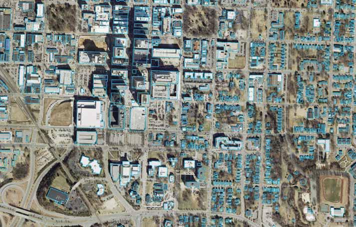
28 Exposure Identification - Statewide Building Footprints


29 Field Collection First Floor Elevation Foundation Type Roof Shape Roof Slope Number of Stories Parcel Conflation Occupancy Type Building Value Year Built Heated Sq Ft Roof Shape HAZUS Block Conflation Roof Cover Type Roof Cover Quality Water Resistance Roof Deck Attachment Roof Deck Age Roof Wall Connection Roof Frame Type Hurricane Shutters Roof Tie Downs Window Area Masonry Reinforcing Joist Spacing Number of Units

30 Risk Management Structure Data First Floor Elevations Aug 2014 Aug 2014 Sept 2014 July 2014 Complete

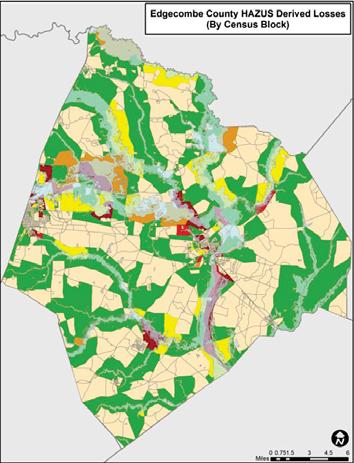
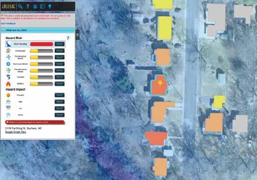
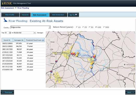
31 Edgecombe
32 New Edgecombe Durham Macon Hanover County Analysis Impacted Total Losses ($) Type Structures irisk 1,733 7,353 1, $1,859,858,451 $218,184,903 $136,041,414 $77,586,478 Census Level 4,652 2, $1,112,166,000 $161,437,000 $724,938,000 $73,767,000 Census Level Variation 108% Census Level Variation -46% Census Level Variation -40% Census Level Variation 232%

33 All Natural Hazards Risk Assessments Statewide Completion Dates April 2014 March 2014 March 2015 May 2014 July 2014 June 2014


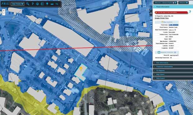
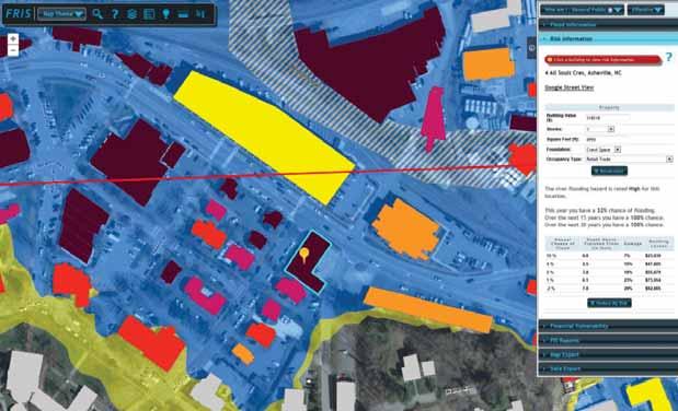
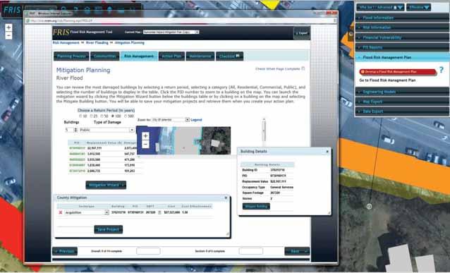
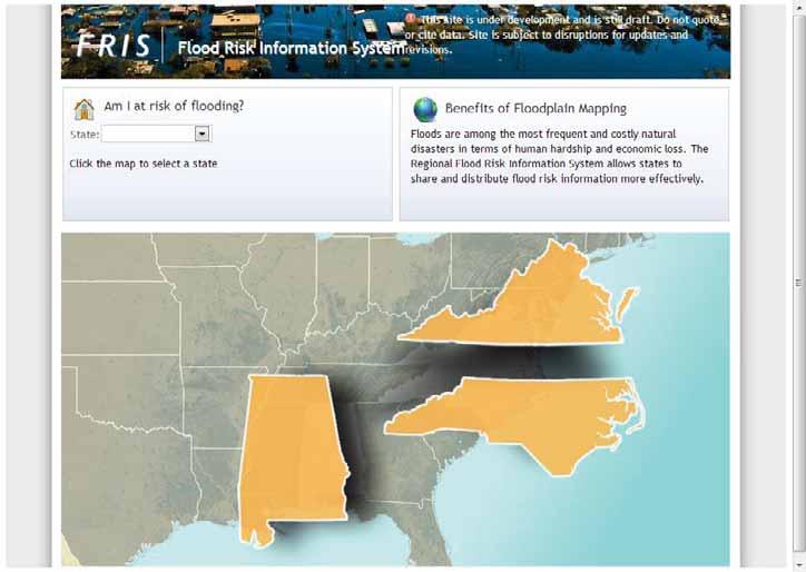
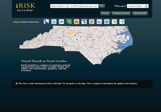
34 FRIS irisk ReadyNC FIMAN Flood Insurance nce Study Flood Risk Map Flood Risk Report
35
36

37


 Multi-Hazard Mitigation")


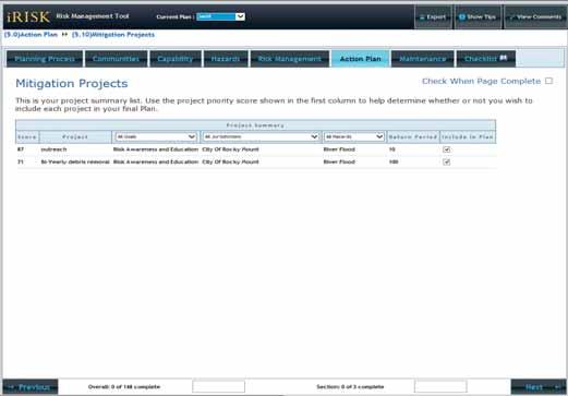
38 School Risk Management Plan School Safety Risk Management Plan Child Care Facility Risk Management Plan RMT Fuel Risk Management Plan Child Care Facility Risk Management Plan Fuel Risk Management Plan Mental Health Facility Disaster Plan License Care Facility Disaster Plan New Hanover County Recovery Disaster Plan Flood Risk Mgmt. Plan (FRMP) Multi-Hazard Mitigation Plan Dam Emergency Action Plan Mental Health Facility Disaster Plan License Care Facility Disaster Plan County Recovery Disaster Plan
39 The SERA and SRMP Tool System

40 Annotated Floor Plans

41 SERA: General School View

42 SERA: Hazard Specific View

43 SERA: View Photos
44
45
46
47
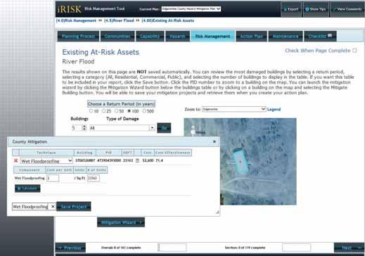
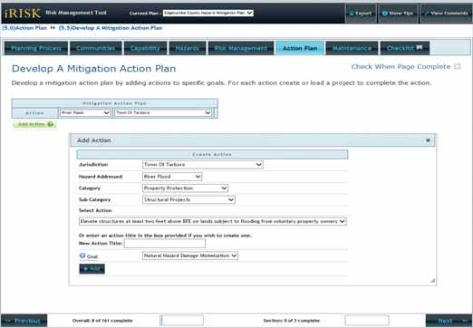
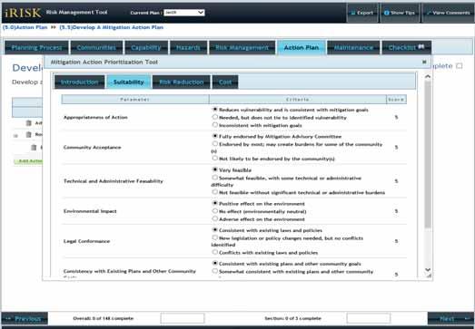
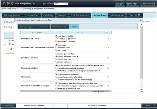
48 Risk Management Key Components and Condition Risk Monitoring All-Digital / Free, Access by Planners and Decision Makers Hazard Plans allow for One Hazard at a Time Will be tied to the Flood Hazard Update 3 ½ to 5 year cycle Risk Mitigation IRISK and RMT are integrated with Hazard Identification or Risk Assessment Focus is on Analysis and Mitigation Strategies Defined Mitigation Strategies and ROI Prioritization Methodology in Place All-Digital / Versioning Risk Management Hazard Identification Low Resolution Mapping Lack Comprehensive Mapping of Hazards Central Location for Methodologies / Models Risk Assessment Acquired Vulnerability Data Constructing / Acquired Impact Models No Interdependency Failure Modeling irisk Provides Risk Assessment for Decision Makers (Financial)

49 INTEGRATED HAZARD RISK MANAGEMENT LIFECYCLE DEMONSTRATION Proposed Counties


")
50 ALL HAZARDs Risk Management Lifecycle Concept Strategy / Action Monitor / Evaluation Pre-Resilience Meeting Resilience Meeting Adoption Funding All Hazard Mapping / Risk Analysis Prelim. Appeals and Protest Period LFD Public Hearings Process / Product Review of Hazard Risk Strategies Identify Hazards Requiring Assessments Establish Hazard Risk Mapping and Assessment Community Charter Updates data on: All Hazards Buildings CI/KR Parcel - Conflation Analysis H&H Analysis SFHA Mapping Other Hazards Raster Datasets FRIS / Risk Analysis irisk Database Products / Tasks Introduction of FRIS and irisk Preliminary FIRM Changes Since Last FIRM Draft Risk MAP Risk Analysis by Structure FRMP Draft Attendees Public Officials / Staff Mitigation Officers Public Meeting for Flood Risk Datasets FIRM (Final) Risk Map Hot spots Mitigation Strategies Draft FRMP Attendees FPAs Public Officials Mitigation Officers Adopt FRMP Adopt FIRM Data
51 Risk Management New Methodologies / Algorithms Develop and Implement Methodologies / Algorithms to calculate Population at the Structure (includes spatial and temporal analysis) Development and Implement Methodologies to calculate Impact of Man-Made Hazard Impact Analysis on Structures (including damage assessments and debris generation). Development and Implement Methodologies to calculate Impact of Man-Made Hazard Impact Analysis on Infrastructure and Vehicles (roads, water systems, vehicles). Will test on Train Derailment Chemical Disbursement.

52 Train Derailment Chemical Disbursement Impact Analysis Analyses Example
53 Risk Management: Next Generation VISION: Resilient communities that are prepared for, and thus are able to absorb and bounce back from hazards. Seamless risk management lifecycle (identification, assessment, mitigation, monitoring) including funding. Mitigation strategies and funding tied to true risk: impact to built and living environment; and community s capability to respond / recover.
54 Risk Management: Prerequisites To Achieve Next Generation Construction / Enhancement / Refinement Spatial Data and Models Associated with Built and Living Systems, and ALL Hazards (natural and man-made). Transition from Cartographic Environment to a Database-Driven, Digital Display Environment (Completed). Statewide Risk Assessment of ALL-Hazards (natural and man-made). Integrated ALL-Hazards Risk Management Lifecycle Process / Framework. Consolidation of Funding Streams to support each Phase of the All- Hazards Risk Management Lifecycle Process. Establishment / Utilization of Venue / Framework for Partnering, Leveraging and Sharing of Risk Management Methodologies, Models, an Systems.
55 DISCUSSION


56 Safer School Risk Management Viewer QUESTIONS?
Non Regulatory Risk MAP Products Flood Depth and Probability Grids
 Non Regulatory Risk MAP Products Flood Depth and Probability Grids Virginia Floodplain Management Association 2015 Floodplain Management Workshop October 29th, 2015 Nabil Ghalayini, P.E., PMP, D.WRE, CFM
Flood Risk Assessment in the
 Georgia Flood M.A.P. Program Flood Risk Assessment in the Upper Chattahoochee h h River Basin GAFM Annual Conference March 28, 2012 Agenda Map Mod to Risk MAP (Georgia Flood M.A.P.) transition Flood Risk
Kentucky Risk MAP It s not Map Mod II
 Kentucky Risk MAP It s not Map Mod II Risk Mapping Assessment and Planning Carey Johnson Kentucky Division of Water carey.johnson@ky.gov What is Risk MAP? Risk Mapping, Assessment, and Planning (Risk MAP)
David A. Stroud, CFM AMEC Earth & Environmental Raleigh, NC
 David A. Stroud, CFM AMEC Earth & Environmental Raleigh, NC Objectives Risk MAP background North Carolina s Risk MAP role Role of communication in Risk MAP Effective risk communication two examples Multi-hazard
Wildfire and Flood Hazards, Using GIS Tools to Assess Risk
 Wildfire and Flood Hazards, Using GIS Tools to Assess Risk Floodplain Management Association Conference, Rancho Mirage, CA September 2015 Thoughts To Keep In Mind What advantages are there in looking at
RFQ # PRE-SUBMITTAL CONFERENCE
 RFQ # 563-00005 PRE-SUBMITTAL CONFERENCE November 15, 2018 HAZARD RISK AND RESPNSDE MANAGEMENT FRAMEWORK PRESENT DATA AND APPLICATIONS PLANNING, PREPAREDNESS, PREVENTION, MITIGATION REAL-TIME, SCENARIO
Georgia Flood M.A.P. Program
 Georgia Flood M.A.P. Program Georgia Flood M.A.P. Program The Upper Chattahoochee River Basin Risk MAP Project Transitioning State Program to align with FEMA s Risk MAP Program Increase focus on risk assessment
Use of FEMA Non regulatory Flood Risk Products in Planning
 Use of FEMA Non regulatory Flood Risk Products in Planning Georgia Association of Floodplain Managers Annual Conference March 24, 2016 What are the Non regulatory Flood Risk products? Go beyond the basic
Flood Risk Products. New Techniques for Identifying and Communicating Flood Risk
 Flood Risk Products New Techniques for Identifying and Communicating Flood Risk Mark Zito, GISP, CFM GIS Specialist Amol Daxikar, GISP, CFM Project Manager March 28, 2012 1% Flood with 3 Feet Sea Level
N.C. Floodplain Mapping Program
 N.C. Floodplain Mapping Program Current Status and Update April 23, 2018 NCFMP Program Objectives Purpose: Develop, Maintain, and Disseminate current, accurate, digital flood hazard data for all of NC,
ASFPM Partnerships for Statewide Mitigation Actions. Alicia Williams GIS and HMP Section Manager, Amec Foster Wheeler June 2016
 ASFPM Partnerships for Statewide Mitigation Actions Alicia Williams GIS and HMP Section Manager, Amec Foster Wheeler June 2016 Summary The Concept Leveraging Existing Data and Partnerships to reduce risk
3D Elevation Program (3DEP) Status and Plans. Kevin T. Gallagher Associate Director, Core Science Systems June 26, 2017
 Status and Plans. Kevin T. Gallagher Associate Director, Core Science Systems June 26, 2017") + 3D Elevation Program (3DEP) Status and Plans Kevin T. Gallagher Associate Director, Core Science Systems June 26, 2017 + 2 3D Elevation Program (3DEP) Apply lidar technology to map bare earth and 3D
+ 3D Elevation Program (3DEP) Status and Plans Kevin T. Gallagher Associate Director, Core Science Systems June 26, 2017 + 2 3D Elevation Program (3DEP) Apply lidar technology to map bare earth and 3D
Best Practices. for Incorporating Building Science Guidance into Community Risk MAP Implementation November 2012
 Best Practices for Incorporating Building Science Guidance into Community Risk MAP Implementation November 2012 Federal Emergency Management Agency Department of Homeland Security 500 C Street, SW Washington,
Bucks County, PA Flood Risk Review Meeting. November 2014
 Bucks County, PA Flood Risk Review Meeting November 2014 Agenda for Today Risk MAP Program overview Overview of non-regulatory Flood Risk Products and datasets Discuss mitigation action Technical overview
Location: Tampa, Florida March 6, 2013
 Discovery Meeting: West Florida Coastal Study Location: Tampa, Florida March 6, 2013 Agenda Introductions Why we are here Outline Risk MAP products and datasets Discovery Overview: Project scoping and
Leveraging HAZUS for Risk Assessment Analysis within Risk MAP
 Leveraging HAZUS for Risk Assessment Analysis within Risk MAP Jen Meyer - FEMA Region X Shane Parson - RAMPP PTS Team (URS Corp.) 2010 HAZUS Conference - August 2010 The Paradigm Shift: Map Mod to Risk
The Citadel. Multi-Hazard Mitigation Disaster Resistant University Plan
 The Citadel Multi-Hazard Mitigation Disaster Resistant University Plan Project Objective To Develop a Disaster Resistant University Hazard Mitigation Plan Identify Hazards Profile Hazards Inventory Assets
3DEP Coalition Meeting. Kevin T. Gallagher Associate Director, Core Science Systems November 10, 2016
 + 3DEP Coalition Meeting Kevin T. Gallagher Associate Director, Core Science Systems November 10, 2016 + 2 3DEP Status 2023 + 3 3D Elevation Program (3DEP) Mission Critical Applications Geologic Hazards
Integrating Hazus into the Flood Risk Assessment
 Integrating Hazus into the Flood Risk Assessment GAFM Conference, March 22, 2016 Mapping Assessment Planning Agenda What is Hazus & Risk Assessment? Census Block vs. Site Specific Analysis User Defined
GIS - Introduction and Sample Uses
 PDHonline Course L145 (5 PDH) GIS - Introduction and Sample Uses Instructor: Jonathan Terry, P.L.S. 2012 PDH Online PDH Center 5272 Meadow Estates Drive Fairfax, VA 22030-6658 Phone & Fax: 703-988-0088
Michael Taylor, PE, CFM Project Manager, AECOM August 25, 2015
 Promoting FEMA s Flood Risk Products in the Lower Levisa Watershed Michael Taylor, PE, CFM Project Manager, AECOM August 25, 2015 Agenda Study Background Flood Risk Product Overview AOMI and Mitigation
AIR Worldwide Analysis: Exposure Data Quality
 AIR Worldwide Analysis: Exposure Data Quality AIR Worldwide Corporation November 14, 2005 ipf Copyright 2005 AIR Worldwide Corporation. All rights reserved. Restrictions and Limitations This document may
Updated Total Exposure in Floodplain (TEIF) Method. Cynthia McCoy, FEMA Region X James Mawby, RAMPP (Dewberry)
 Method. Cynthia McCoy, FEMA Region X James Mawby, RAMPP (Dewberry)") Updated Total Exposure in Floodplain (TEIF) Method Cynthia McCoy, FEMA Region X James Mawby, RAMPP (Dewberry) What Are We Doing? Saving lives! Protecting property! 2 Need - Alternative Approach to Evaluate
Updated Total Exposure in Floodplain (TEIF) Method Cynthia McCoy, FEMA Region X James Mawby, RAMPP (Dewberry) What Are We Doing? Saving lives! Protecting property! 2 Need - Alternative Approach to Evaluate
National Capitol Region HAZUS User Group Call
 Listen to the recording here to follow along with the presentation: http://www.freeconferencecalling.com/recordings/recording.aspx?fileid=l AF3494_04252013070630062_1154707&bridge=697620&email=&account
GIS - Introduction and Sample Uses
 PDHonline Course L145 (5 PDH) GIS - Introduction and Sample Uses Instructor: Jonathan Terry, P.L.S. 2012 PDH Online PDH Center 5272 Meadow Estates Drive Fairfax, VA 22030-6658 Phone & Fax: 703-988-0088
Discovery Meeting: Middle Potomac- Catoctin Watershed. FEMA REGION III September 26, 2012 Rockville, MD and Fairfax, VA
 Discovery Meeting: Middle Potomac- Catoctin Watershed FEMA REGION III September 26, 2012 Rockville, MD and Fairfax, VA Agenda Introductions Purpose of This Meeting Discovery Process Community Rating System
New Tools for Mitigation & Outreach. Louie Greenwell Stantec
 New Tools for Mitigation & Outreach Louie Greenwell Stantec Our Discussion Today Background What is Risk MAP? FEMA Products Overview of RiskMAP Data Sets Changes Since Last FIRM Depth and Analysis Grids
SOUTH CENTRAL REGION MULTI-JURISDICTION HAZARD MITIGATION PLAN. Advisory Committee Meeting September 12, 2012
 SOUTH CENTRAL REGION MULTI-JURISDICTION HAZARD MITIGATION PLAN Advisory Committee Meeting September 12, 2012 AGENDA FOR TODAY Purpose of Meeting Engage All Advisory Committee Members Distribute Project
Not Your Average Risk Assessment: Multi-Stage Risk Assessments for Sites in the Passaic River Basin Stuart Geiger, CFM Joseph Ruggeri, PE, CFM
 Not Your Average Risk Assessment: Multi-Stage Risk Assessments for Sites in the Passaic River Basin Stuart Geiger, CFM Joseph Ruggeri, PE, CFM Agenda Project Background Risk Assessment Development Refined
Orange County Flood Insurance Study Update
 Orange County Flood Insurance Study Update Larry Voice FEMA Region VI August 26, 2009 AGENDA Introduction Study Overview and Status Update Levees Post-Preliminary Process Outreach Moving Forward 2 Introduction
Results from ECA study: Florida
 Results from ECA study: Florida Lauren Toretta McKinsey Mark Way Swiss Re Mitigation is important, but it will take decades to achieve success Global greenhouse gas emissions: Gt COe per year Slide 75
Georgia Silver Jackets Team
 Georgia Silver Jackets Team 9 th Annual GAFM Technical Conference Jeff Morris GA SJ Collaborator Savannah District, USACE US Army Corps of Engineers SMART GOVERNMENT Integrate and synchronize flood risk
INTRODUCTION TO NATURAL HAZARD ANALYSIS
 INTRODUCTION TO NATURAL HAZARD ANALYSIS November 19, 2013 Thomas A. Delorie, Jr. CSP Managing Director Natural Hazards Are Global and Include: Earthquake Flood Hurricane / Tropical Cyclone / Typhoon Landslides
LOCAL HAZARD MITIGATION PLAN REVIEW WORKSHEET FEMA REGION 2 Jurisdiction: Jurisdiction: Title of Plan: Date of Plan: Address:
 REVIEW AD APPROVAL TATU Title of Plan: Date of Plan: Local Plan submitted by: Address: Title: Agency: Phone umber: E-Mail: tate Reviewer: Title: Date: FEMA Reviewer: Title: Date: FEMA QA/QC: Title: Date:
Durham County Preliminary Flood Hazard Data Public Meeting. July 28, 2016
 Durham County Preliminary Flood Hazard Data Public Meeting July 28, 2016 Why Are We Here New flood hazard data has been released as Preliminary for Durham County Statutory Due Process for review/comments
VULNERABILITY ASSESSMENT
 SOUTHSIDE HAMPTON ROADS HAZARD MITIGATION PLAN VULNERABILITY ASSESSMENT INTRODUCTION The Vulnerability Assessment section builds upon the information provided in the Hazard Identification and Analysis
Title of Nomination: Flood Plain Mapping Project/System Manager: John Dorman. Center for Geographic Information Analysis Department: Address:
 Title of Nomination: Flood Plain Mapping Project/System Manager: John Dorman Job Title: Project Manager Agency: Center for Geographic Information Analysis Department: Address: City: Raleigh State: NC Zip:
Flood Solutions. Summer 2018
 Flood Solutions Summer 2018 Flood Solutions g Summer 2018 Table of Contents Flood for Lending Life of Loan Flood Determination... 2 Multiple Structure Indicator... 2 Future Flood... 2 Natural Hazard Risk...
Georgia Flood M.A.P. Program Risk MAP Plenary Session GAFM 2011
 Georgia Flood M.A.P. Program Risk MAP Plenary Session GAFM 2011 Collis Brown, Georgia DNR March 24, 2011 GA Flood Map Modernization Responsible for end-to-end production Developed aggressive outreach program
Oklahoma High Water Marks. CTP Community of Practice April 20, 2017
 Oklahoma High Water Marks CTP Community of Practice April 20, 2017 The Rains Came into Region 6 in May 2015 2 Disaster DR-4222 30 Day Rainfall 3 NOAA Rainfall Amounts / Rainfall Frequency 4 The Rains in
Chemung HUC-8 Watershed Project. February 1, 2011
 Chemung HUC-8 Watershed Project Kickoff Bi Fl t NY Big Flats, NY February 1, 2011 Introductions FEMA Region II Alan Springett, Senior Engineer, FEMA Risk Analysis Risk Assessment Lead Robert Schaefer,
Survey of Hazus-MH: FEMA s Tool for Natural Hazard Loss Estimation
 Survey of Hazus-MH: FEMA s Tool for Natural Hazard Loss Estimation What is Hazus? Software tools and support system designed by FEMA for the purpose of providing communities with the means to identify
Hazard Mitigation Planning
 Hazard Mitigation Planning Mitigation In order to develop an effective mitigation plan for your facility, residents and staff, one must understand several factors. The first factor is geography. Is your
County of Kaua'i Multi-Hazard Mitigation and Resilience Plan, 2015 Update
 Executive Summary: County of Kaua'i Multi-Hazard Mitigation and Resilience Plan Introduction to the Mitigation and Resilience Plan In this third plan, the longer term needs for sustaining mitigation efforts
Overview of Capabilities and Current Limitations
 Overview of Capabilities and Current Limitations Overview of the National Flood Risk Characterization Tool (NFRCT) Map based viewer of relative flood risk around the U.S., with supporting reports for more
SECTION 6 - RANGE OF ALTERNATIVE MITIGATION ACTIONS CONSIDERED
 SECTION 6 - RANGE OF ALTERNATIVE MITIGATION ACTIONS CONSIDERED For this hazard mitigation plan to be approved by FEMA, each participating jurisdiction was required to identify and analyze a comprehensive
Discovery Meeting: Lake Ontario. FEMA REGION II November 12-14, 2013 and November 19-21, 2013 Lake Ontario Contributing Watersheds
 Discovery Meeting: Lake Ontario FEMA REGION II November 12-14, 2013 and November 19-21, 2013 Lake Ontario Contributing Watersheds Introductions and Who s Here Project Team FEMA Region II Dewberry New York
Piloting LAMP from Stream to Sea
 Piloting LAMP from Stream to Sea FEMA s New Analysis and Mapping Procedures for Non-Accredited Levee Systems Presented by: Eric Simmons, CFM Senior Engineer, FEMA Region IX Presentation Outline Levee Issues
Talk Components. Wharton Risk Center & Research Context TC Flood Research Approach Freshwater Flood Main Results
 Dr. Jeffrey Czajkowski (jczaj@wharton.upenn.edu) Willis Research Network Autumn Seminar November 1, 2017 Talk Components Wharton Risk Center & Research Context TC Flood Research Approach Freshwater Flood
CRS UNIFORM MINIMUM CREDIT NORTH CAROLINA
 CRS UNIFORM MINIMUM CREDIT NORTH CAROLINA SUMMARY The Community Rating System (CRS) provides Uniform Minimum Credit (UMC) for certain state laws, regulations, and standards that support floodplain management
Community Resilience & NFIP s Community Rating system
 Community Resilience & NFIP s Community Rating system Ajita Atreya Wharton Risk Management and Decision Processes Center University of Pennsylvania National Association of Counties (NACo) Session on Risk
Flood Risk Resilience in Alabama: Challenges and Successes
 Flood Risk Resilience in Alabama: Challenges and Successes Leslie A. Durham, P.E. Floodplain Management Branch Chief Alabama Office of Water Resources 10 Year Partnership with FEMA Flood Map Modernization
Emergency Management. December 16, 2010
 Applications of Hazus-MH for Emergency Management December 16, 2010 What is Hazus-MH? Free ArcGIS extension Facilitates a risk-based approach to mitigation Identifies and visually displays hazards and
National Elevation Data for National Flood Insurance Policy; NFIP & 3DEP Efforts John JB Byrd of John M. Palatiello & Associates, Inc.
 National Elevation Data for National Flood Insurance Policy; NFIP & 3DEP Efforts John JB Byrd of John M. Palatiello & Associates, Inc. Government Affairs Manager (MAPPS) Lobbyist (NSPS) November 3, 2015
in coordination with Peoria County, Planning and Zoning Department
 Prepared by Amec Foster Wheeler Environment & Infrastructure Hazard Mitigation and Emergency Management Program in coordination with Peoria County, Planning and Zoning Department The purpose of hazard
City of Pensacola and Escambia County Flood Risk and Flood Insurance Study
 City of Pensacola and Escambia County Flood Risk and Flood Insurance Study Preliminary Report 1: Long Hollow and Sanders Beach Tracts Wharton Risk Management and Decision Processes Center November 8, 2016
Flood Map Revisions. Town of Nags Head Public Information and Input Session. December 14, 2016, 6 pm
 Flood Map Revisions Town of Nags Head Public Information and Input Session December 14, 2016, 6 pm Flood Map Revisions New preliminary flood maps released for Dare County June 30, 2016 www.nagsheadnc.gov/floodmaps
Northern Kentucky University 2018 Hazard Mitigation Plan. Public Kick-Off Meeting March 20, 2018
 Northern Kentucky University 2018 Hazard Mitigation Plan Public Kick-Off Meeting March 20, 2018 Agenda Welcome Hazard Mitigation Planning 101 Hazard Identification Exercises Next Steps Jeff Baker, NKU
Outreach Georgia Flood M.A.P. Program. GAFM Technical Conference Flood Risk Outreach and Policy Session
 Outreach Georgia Flood M.A.P. Program GAFM Technical Conference Flood Risk Outreach and Policy Session 7 th Annual Technical Conference, Lanier Islands March 29, 2012 Risk Communication Key Learnings People
Region VIII Applications of Nationwide HAZUS Flood and Earthquake Modeling-Multi
 Region VIII Mitigation GIS Region VIII Applications of Nationwide HAZUS Flood and Earthquake Modeling-Multi Multi- Hazard Vulnerability Index 22 May 2009, EF-3 Tornado Forms in Northern Colorado http://www.allamericanpatriots.com/48747834_colorado-gov-ritter-issues-formal-disaster-declara
CHAPTER THREE Natural Hazard Mitigation Strategy
 CHAPTER THREE Natural Hazard Mitigation Strategy Chapter 3 Section All Sections Updates to Section Revised Natural Hazards Introduction and all Sections to change Natural Hazards Subcommittee to Committee.
REQUEST FOR PROPOSALS. Planning in Water s Way: Flood Resilient Economic Development Strategy for the I-86 Innovation Corridor
 REQUEST FOR PROPOSALS Planning in Water s Way: Flood Resilient Economic Development Strategy for the I-86 Innovation Corridor Southern Tier Central Regional Planning and Development Board (STC) is seeking
Modernization, FEMA is Recognizing the connection between damage reduction and
 EXECUTIVE SUMMARY Every year, devastating floods impact the Nation by taking lives and damaging homes, businesses, public infrastructure, and other property. This damage could be reduced significantly
Calhoun County Flood Insurance Study Update
 Calhoun County Flood Insurance Study Update Larry Voice FEMA Region VI September 18, 2009 AGENDA Introduction Study Overview and Status Update Levees Post-Preliminary Process Outreach Moving Forward 2
NFIP Mapping Issues. Wendy Lathrop, PLS, CFM. Cadastral Consulting, LLC
 NFIP Mapping Issues Cadastral Consulting, LLC NFIP Basic Objectives: Reduce the exposure to flood damages through the use of minimum standards for the placement and design of structures located in flood
Presenters. Bracken Engineering. Structures Disasters Forensics
 Presenters Bill Bracken, PE John Minor, CGC Bracken Engineering Structures Disasters Forensics Hurricane Ike Pre & Post FIRM Ike Pre Firm Post Firm FEMA Background The NFIP requires the mortgage loans
Town of Montrose Annex
 Town of Montrose Annex Community Profile The Town of Montrose is located in the Southwest quadrant of the County, east of the Town of Primrose, south of the Town of Verona, and west of the Town of Oregon.
Mapping Flood Risk in the Upper Fox River Basin:
 Mapping Flood Risk in the Upper Fox River Basin: Vulnerable Populations and Adverse Health Effects Presented by: Angelina Hanson STUDY AREA: Wisconsin's Upper Fox River Basin Total Population 139,309.
Appendix F: Ozark special Road District Addendum
 Appendix F: Ozark special Road District Addendum F-1: Introduction and Planning Process F-1.1 Purpose The Christian County 2016 Multi-Jurisdictional Natural Hazards Mitigation Plan is an updated version
USACE Silver Jackets, the Missouri State Risk Management Team and State Hazard Mitigation
 MfSMA Conference, State Risk Management Team Meeting Things You Want To Know USACE Silver Jackets, the Missouri State Risk Management Team and State Hazard Mitigation Brian Rast, PE, CFM, PMP Silver Jackets
Village of Blue Mounds Annex
 Village of Blue Mounds Annex Community Profile The Village of Blue Mounds is located in the southwest quadrant of the County, north of the town of Perry, west of the town of Springdale, and south of the
Delaware Bay / River Coastal Flood Risk Study. FEMA REGION II and III September 19, 2012
 Delaware Bay / River Coastal Flood Risk Study FEMA REGION II and III September 19, 2012 Agenda Risk MAP Program Overview Risk MAP Non-Regulatory Products & Datasets Region II New Jersey Coastal Flood Study
PUBLIC SURVEY FOR HAZARD MITIGATION PLANNING
 PUBLIC SURVEY FOR HAZARD MITIGATION PLANNING We need your help! The Counties of Cherokee, Graham, Haywood, Jackson, Swain, and the Eastern Band of Cherokee Indians are currently engaged in a planning process
G318 Local Mitigation Planning Workshop. Module 2: Risk Assessment. Visual 2.0
 G318 Local Mitigation Planning Workshop Module 2: Risk Assessment Visual 2.0 Unit 1 Risk Assessment Visual 2.1 Risk Assessment Process that collects information and assigns values to risks to: Identify
APPENDIX D PLANNING PROCESS DOCUMENTATION
 APPENDIX D PLANNING PROCESS DOCUMENTATION This appendix includes the following: 1. Meeting Agendas 2. Meeting Minutes 3. Meeting Sign-In Sheets 4. Public Survey Summary Results 1) Introductions AGENDA
Garfield County NHMP:
 Garfield County NHMP: Introduction and Summary Hazard Identification and Risk Assessment DRAFT AUG2010 Risk assessments provide information about the geographic areas where the hazards may occur, the value
Understanding CCRIF s Hurricane, Earthquake and Excess Rainfall Policies
 Understanding CCRIF s Hurricane, Earthquake and Excess Rainfall Policies Technical Paper Series # 1 Revised March 2015 Background and Introduction G overnments are often challenged with the significant
Resilience and the Economics of Risk. NACo s Resilient Counties Advisory Board February 2016
 Resilience and the Economics of Risk NACo s Resilient Counties Advisory Board February 2016 The growing burden of uninsured losses Natural catastrophe losses 1970 2014 (in 2014 USD) 450 400 350 300 Uninsured
NFIP Program Basics. KAMM Regional Training
 NFIP Program Basics KAMM Regional Training Floodplain 101 Homeowners insurance does not cover flood damage Approximately 25,000 flood insurance policies in KY According to BW12 analysis, approximately
OTTAWA COUNTY AND SANDUSKY COUNTY COMMUNITY CONSULTATION OFFICERS (CCO) MEETING December 7, 2017
 MEETING December 7, 2017") OTTAWA COUNTY AND SANDUSKY COUNTY COMMUNITY CONSULTATION OFFICERS (CCO) MEETING December 7, 2017 TODAY S AGENDA The Value of Updated Flood Maps for Your Community Reviewing the Updated Flood Risk Data
OTTAWA COUNTY AND SANDUSKY COUNTY COMMUNITY CONSULTATION OFFICERS (CCO) MEETING December 7, 2017 TODAY S AGENDA The Value of Updated Flood Maps for Your Community Reviewing the Updated Flood Risk Data
Southwest Florida Discovery Kick-Off Meeting. February 4, 2014
 Southwest Florida Discovery Kick-Off Meeting February 4, 2014 Agenda Introductions Outline Risk MAP products and datasets Project scoping and schedule Data gathered Next steps Gather stakeholder input/feedback
Accounting for Long-Term Erosion and Sea Level Rise in New England: A TMAC Recommendation
 Accounting for Long-Term Erosion and Sea Level Rise in New England: A TMAC Recommendation Elena Drei-Horgan, PhD, CFM Jeremy Mull, PE Brian Caufield, PE May 2017 Establishment of TMAC, Definition, Members
LOCAL MITIGATION PLAN REVIEW CROSSWALK
 INSTRUCTIONS FOR USING THE PLAN REVIEW CROSSWALK FOR REVIEW OF LOCAL MITIGATION PLANS Attached is a Plan Review Crosswalk based on the Local Multi-Hazard Mitigation Planning Guidance, published by FEMA
Updates to Maine Coastal Flood Insurance Rate Maps (FIRM s): What a Local Official Should Know. Presented by: Steve Johnson, P.E.
: What a Local Official Should Know. Presented by: Steve Johnson, P.E.") Updates to Maine Coastal Flood Insurance Rate Maps (FIRM s): What a Local Official Should Know Presented by: Steve Johnson, P.E. Town Engineer October 4, 2018 Introduction Federal Emergency Management
Updates to Maine Coastal Flood Insurance Rate Maps (FIRM s): What a Local Official Should Know Presented by: Steve Johnson, P.E. Town Engineer October 4, 2018 Introduction Federal Emergency Management
Enough about me! Topics Covered
 About Me Worked in land surveying since 1997 Employed by the City of Orlando since 2006 City of Orlando City Surveyor since February 2015 Certified Floodplain Manager since 2015 Florida Licensed Surveyor,
Middlesex County Timeline
 Community Coordination Meeting for Middlesex County, Connecticut Risk MAP Study November 9, 2011 Agenda Welcome and Introductions Project Timeline Coastal Flood Hazard Analysis Recap Public Review and
INSURANCE AFFORDABILITY A MECHANISM FOR CONSISTENT INDUSTRY & GOVERNMENT COLLABORATION PROPERTY EXPOSURE & RESILIENCE PROGRAM
 INSURANCE AFFORDABILITY A MECHANISM FOR CONSISTENT INDUSTRY & GOVERNMENT COLLABORATION PROPERTY EXPOSURE & RESILIENCE PROGRAM Davies T 1, Bray S 1, Sullivan, K 2 1 Edge Environment 2 Insurance Council
FREQUENTLY ASKED QUESTION ABOUT FLOODPLAINS Michigan Department of Environmental Quality
 FREQUENTLY ASKED QUESTION ABOUT FLOODPLAINS Michigan Department of Environmental Quality WHAT IS A FLOOD? The National Flood Insurance Program defines a flood as a general and temporary condition of partial
Mike Waters VP Risk Decision Services Bob Shoemaker Sr. Technical Coordinator. Insurance Services Office, Inc
 Mike Waters VP Risk Decision Services Bob Shoemaker Sr. Technical Coordinator Insurance Services Office, Inc Disasters Large and Small A Convergence of Interests Public and Private ESRI Homeland Security
Erie County Flood Risk Review Meeting. January 18, 2018
 Erie County Flood Risk Review Meeting January 18, 2018 Agenda The value of updated flood maps for your community Review updated flood-risk data and important next steps in the Risk MAP process Increasing
DeSoto Parish Hazard Mitigation Plan Update Kick-off Meeting. February 16, 2016 Grand Cane, LA
 DeSoto Parish Hazard Mitigation Plan Update Kick-off Meeting February 16, 2016 Grand Cane, LA Introductions Officials Mitigation Steering Committee members SDMI team members GOHSEP hazard mitigation team
GEO CODING IN NAT CAT UNDERWRITING. 2. Part I: CRESTA in NAT Cat Underwriting. 3. Part II: NATHAN in NAT Cat Underwriting
 GEO CODING IN NAT CAT UNDERWRITING 5th ICRM Roundtable Matti Siitonen / Munich Re (Singapore Branch) Singapore, 28 February 2014 Agenda 1. Introduction to Geo Coding: - Where are we today? - Principles
Tangipahoa Parish Hazard Mitigation Plan Update Mitigation Steering Committee Kick-off Meeting. September 9, 2014 Hammond, LA
 Tangipahoa Parish Hazard Mitigation Plan Update Mitigation Steering Committee Kick-off Meeting September 9, 2014 Hammond, LA Introductions Officials Mitigation Steering Committee members SDMI team members
NATURAL PERILS - PREPARATION OR RECOVERY WHICH IS HARDER?
 NATURAL PERILS - PREPARATION OR RECOVERY WHICH IS HARDER? Northern Territory Insurance Conference Jim Filer Senior Risk Engineer Date : 28 October 2016 Version No. 1.0 Contents Introduction Natural Perils
GAFM Showcase: Multiple Agencies Combating Georgia s Flood Risk Together: Proven Results Gained by Strong Partnerships
 National Flood Insurance Program Participation GAFM Showcase: Multiple Agencies Combating Georgia s Flood Risk Together: Proven Results Gained by Strong Partnerships Moderator: Jill Bazinet, PE, CFM GAFM
Risk, Mitigation, & Planning
 Risk, Mitigation, & Planning Lessons from Flooding in the Houston Area Russell Blessing, Samuel Brody & Wesley Highfield CUMULATIVE FLOOD LOSS: 1972-2015 INSURED FLOOD LOSS: 1972-2015 THE HOUSTON-GALVESTON
Overview of Climate Risk Reduction in the US Pacific Islands Hazard Mitigation Planning Efforts
 Hazards, Climate, and Environment Program Social Science Research Institute University of Hawai`i at Mānoa Title: Overview of Climate Risk Reduction in the US Pacific Islands Hazard Mitigation Planning
United States Government Accountability Office GAO. Report to Congressional Requesters. December 2010 FEMA FLOOD MAPS
 GAO United States Government Accountability Office Report to Congressional Requesters December 2010 FEMA FLOOD MAPS Some Standards and Processes in Place to Promote Map Accuracy and Outreach, but Opportunities
Overview of HAZUS for Earthquake Loss Estimation. September 6, 2012
 Overview of HAZUS for Earthquake Loss Estimation September 6, 2012 What is HAZUS? Risk assessment tool for analyzing potential losses from hurricane, flood, and earthquake Uses current scientific and engineering
Sussex County All Hazard Mitigation Plan. Plan Executive Summary
 Sussex County All Hazard Mitigation Plan Plan Executive Summary March 2010 SUSSEX COUNTY ALL HAZARD MITIGATION PLAN SUMMARY March 2010 For questions and to make comments on this document, contact: Joseph