National Elevation Data for National Flood Insurance Policy; NFIP & 3DEP Efforts John JB Byrd of John M. Palatiello & Associates, Inc.
|
|
|
- Sharyl Shelton
- 6 years ago
- Views:
Transcription
 Lobbyist (NSPS) November 3, 2015 before the SMARTERSAFER.")

1 National Elevation Data for National Flood Insurance Policy; NFIP & 3DEP Efforts John JB Byrd of John M. Palatiello & Associates, Inc. Government Affairs Manager (MAPPS) Lobbyist (NSPS) November 3, 2015 before the SMARTERSAFER.ORG - Americans for Smart Natural Catastrophe Policy SmarterSafer.org is a national coalition that is made up of a diverse chorus of voices united in favor of environmentally-responsible, fiscally-sound approaches to natural catastrophe policy that promotes public safety.
2 About MAPPS and NSPS + MAPPS is the only national association of private sector firms in the surveying, spatial data and geographic information systems field in the United States. + The National Society of Professional Surveyors (NSPS) is the national voice of land surveying professionals throughout the United States. 2
, FEMA identifies flood hazards, assesses flood risks and partners with states and communities to provide accurate")
3 The NFIP and Flood Mapping The National Flood Insurance Program (NFIP) is a Federal program enabling property owners in participating communities to purchase flood insurance. FEMA's flood hazard mapping program, Risk Mapping, Assessment and Planning (MAP), FEMA identifies flood hazards, assesses flood risks and partners with states and communities to provide accurate flood hazard data. + Flood hazard mapping is an important part of the NFIP, as it is the basis of the NFIP regulations and flood insurance requirements. 3

4 Characteristics of a Floodplain 4
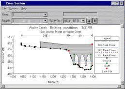
5 Surveying and mapping activities within NFIP Topography (LiDAR, ISFAR, etc) Aerial imagery (flown with topography data collect) Land use and land cover data Field run data collection and cross-sections (overbanks, below water data) Hydraulic structures data (bridge, culvert, and pipe data) Levee and dam data(levee crest elevations, levee closures, dam crest, emergency spillway and outlet structures) Building footprints (for risk analysis) Elevation certificate (flood insurance rating) 5
6 Surveying and mapping processes within NFIP + Topographic data along with land use and land cover and hydraulic structures data is used for development of the watershed hydrology (stream discharge values) and hydraulics and compute the water surface elevations at each cross. + Floodplain delineation on the Flood Insurance Rate Map (FIRM) is based on the elevations derived from the hydraulic models projected on to the topographic data. + Elevation and topographic data are used in performing FEMA levee accreditations and Levee Analysis Mapping Process (LAMP) for levees that can not be accredited + Surveys for elevation certificates for insurance rating and for Letter of Map Amendments (LOMAs) + Risk analysis and assessments using building footprints and building specific information. This information can also be used in mitigation actions 6

7 The Role of the Engineering Company Providing FEMA with program management, engineering, mapping, and related technical services, including the production of flexible and sustainable Risk MAP products to communities. + Benefit to FEMA and Communities - To push action and awareness through the FIRM production process for digital products. - Increase Communities resilience to hazards and communicate risk. 7
8 Discovery The Study Process Overview of the FEMA Study Process Field Survey Base Map Topographic Data Hydrology & Hydraulic Analysis Preliminary Map Products Post-Preliminary Products Community Engagement & Outreach Quality Assurance / Quality Control 8


9 The Mapping Process + Field Survey - Bathymetry - Bridges/Culverts/Hydraulic Structures + Acquire Base Map - Leverage data early in process + Develop Topographic Data - Aerial Photogrammetry - LiDAR (Mobile, Terrestrial, Aerial) 9


10 The Mapping Process + Develop Hydrologic & Hydraulic Data - Stream gage analysis, rainfall/runoff modeling, regression equations - 1-D and 2-D hydraulic modeling + Mapping - Produce regulatory & non-regulatory products - Ensure compliance with FEMA s latest mapping standards 10

")


11 + Risk MAP Products Help Communicate Risk Public Outreach Process Changes Since Last FIRM (CSLF) Percent Chance of Flooding over a 30-Year Period Grid Percent Annual Chance Flooding Grid Flood Velocity Grid 11


12 Development of Educational, Outreach and Training Programs Delivering the right message at the right time the right way. 12

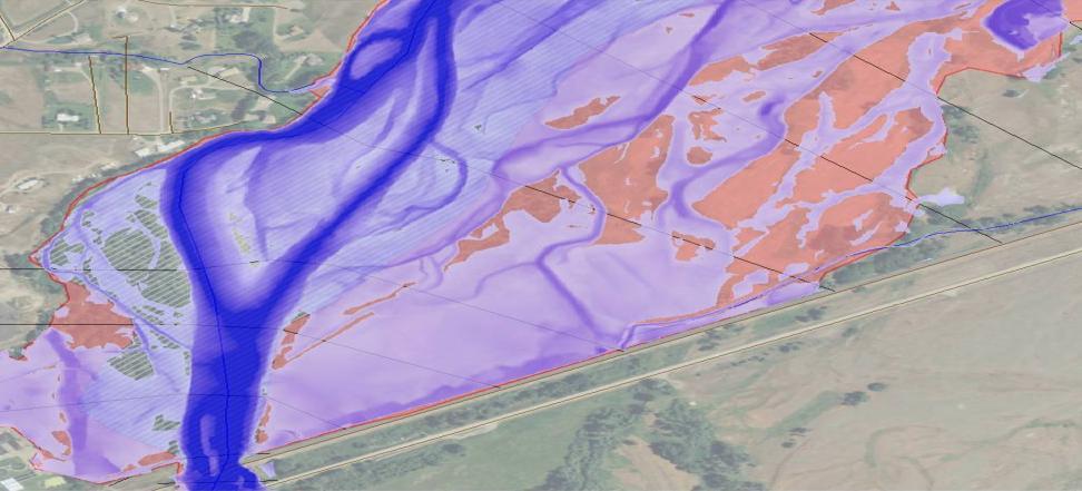
13 Floodplain depth grids with structure data 13


14 Pre- and Post-Disaster Imagery 14


15 Geospatial Platforms Using many sources to produce geospatial content Imagery Vector LiDAR + Many different sources + Workflows + Data centric models + Tools and application Surveying Field Observations Geospatial Storefront Discover Use Share... Integrated geospatial production

16 LiDAR! (Light Detection and Ranging) 16


17 Light Detection and Ranging (LiDAR) Inertial Measurement Unit


18 Three Major Components of a LiDAR System 1. Airborne GPS 2. Inertial Measurement Unit (IMU) 3. Laser Scanner 18


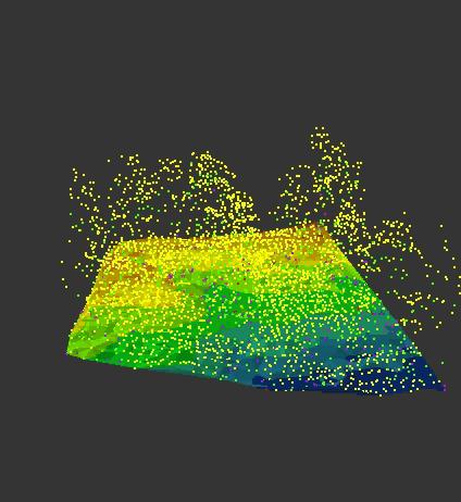
19 LiDAR point cloud 19

20 LiDAR cross section for horizontal/vertical measurements 20

21 Runoff and/or Pollution Patterns 21

22 LiDAR Imagery of Florida Coastline 22

23 + Infrastructure 23 Construction and Management LiDAR Applications Route, grade, line-of-sight, and utility surveys and corridor mapping Terrain and other obstruction identification Dam, levee, and coastal structure failure modeling and mitigation Hydraulic and hydrologic modeling Geotechnical evaluations Permit application and construction plan development and evaluation As-built model development Preliminary engineering, estimate development, and quantity estimation activities Pittsburgh, PA


24 Potential annual $ benefits from LiDAR QL3, $2B/yr for agriculture and precision farming QL3, $7B/yr for land navigation & safety, fuel savings, transmission control QL3, $500M/yr for flood risk management QL1 or QL2, $1B/yr for geologic resource assessment & hazard mitigation 24


25 LiDAR for Multi-Hazard Mitigation Soil Erosion SLR Vulnerabilities Landslide Hazards Seismic Hazards Subsidence Coastal Hazards Runoff Modeling Aviation Safety Dam Break Analysis Levee Failure Transmission Line Vegetation Clearance Emergency Response Fire Modeling Flood Predictions Infrastructure Protection 25


26 Digital Flood Insurance Rate Map (DFIRM) 26


27 Regulatory Products DFIRM Database Non-Regulatory Products Flood Risk Database

28 Changes Since Last FIRM - Before


29 Changes Since Last FIRM - After

30 Changes Since Last FIRM Net Change


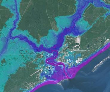
31 Flood Risk Depth Grids Multi-Frequency Riverine Depth Grids Coastal -Depth Grids Percent 30yr Chance


32 Updating Risk Assessments

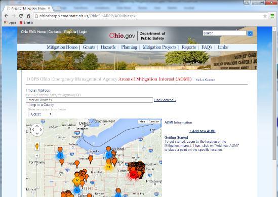


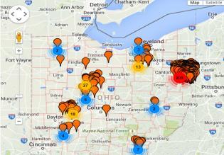
33 Areas of Mitigation Interest Assessing Pinch Points or road overtopping

34 MAP-21 Act + Congress passed the MAP-21 Act in 2012, reauthorizing the federal highway program, reforming and reauthorizing the FEMA flood mapping and insurance program, and reforming student loans. + Agencies are implementing key sections of that law - FEMA on flood mapping; - The elevation provisions effectively provide a specific Congressional authorization for the 3DEP program USGS has launched. 34
35 MAP-21 Importance + NFIP Provisions + Numerous MAPPS and NSPS initiated provisions, including those of the MAPPS FEMA task force; + Section establishes a FEMA technical mapping advisory council (TMAC), to include: a member of a recognized professional surveying association or organization; a member of a recognized professional mapping association or organization; - Section requires National Flood Insurance Program rate maps to use the most accurate topography and elevation data available 35
36 MAP-21 Importance + Numerous MAPPS-initiated provisions, including those of our FEMA task force (Section ): - assesses the accuracy of current ground elevation data used for hydrologic and hydraulic modeling of flooding; - sources and mapping of the flood hazard and wherever necessary acquire new ground elevation data utilizing the most up-to-date geospatial technologies in accordance with guidelines and specifications of the Federal Emergency Management Agency; - develops National Flood Insurance Program flood data on a watershed basis; 36
37 MAP-21 Importance - eliminates, to the maximum extent possible, discrepancies in base flood elevations between adjacent political subdivisions; - publishes maps in a format that is digital geospatial data compliant; and - authorizes appropriations $400,000,000 for each of fiscal years 2013 through 2017 (Section ) 37
38 MAP-21 Importance + Section : - Develops a funding strategy to leverage and coordinate budgets and expenditures, and to maintain or establish joint funding and other agreement mechanisms with other Federal agencies and units of State and local government to share in the collection and utilization of geospatial data among all governmental users. - Specifically mentions OMB, FEMA, USGS, NOAA &USACE 38

39 MAP-21 Importance + Section includes a NAPA study on how FEMA can - improve interagency and intergovernmental coordination on flood mapping, including a funding strategy to leverage and coordinate budgets and expenditures; and - establish joint funding mechanisms with other Federal agencies and units of State and local government to share the collection and utilization of data among all governmental users. 39
40 3D Elevation Program (3DEP) + The National Enhanced Elevation Assessment (NEEA) demonstrated the potential to generate $1.2 billion to $13 billion new benefits annually + Based on the NEEA findings, a cooperatively funded national 3-Dimensional Elevation Program (3DEP) executed by USGS + Plan to acquire high resolution LiDAR data for 49 states, IFSAR in Alaska + The goal is to achieve an 8-year acquisition cycle ($146 Million per year), will satisfy 58% of NEEA-identified requirements + Provide bare earth elevation, point cloud and other data derivatives 40


41 + 41 3DEP + National LiDAR coverage with ifsar in Alaska in 8 years + Address the mission-critical requirements of 34 Federal agencies, 50 states, and other organizations documented in the National Enhanced Elevation Assessment + Return on investment 5:1, conservative benefits of $690 million/year with potential to generate $13 billion/year + Leverage the capability and capacity of private sector mapping firms + Achieve a 25% cost efficiency gain by collecting data in larger projects + Completely refresh national elevation data holdings with new LiDAR and ifsar elevation data products and services Natural Resource Conservation Infrastructure Management Flood Risk Mitigation Precision Farming Land Navigation and Safety Geologic Resources and Hazards Mitigation

42 National Research Council (2007) Existing elevation data are inadequate to support FEMA s needs for the NFIP. Nationwide LiDAR data are required with 2-foot contour accuracy in most terrain and 1- foot contour accuracy in very flat coastal or inland floodplains. Nationwide LiDAR has applications well beyond FEMA s Map Modernization Program. Recommended Elevation for the Nation (EFTN) now known as the 3D Elevation Program (3DEP) 42


43 National Research Council (2009) Finding 1. Topographic data are the most important factor in determining water surface elevations, base flood elevation, and the extent of flooding and, thus, the accuracy of flood maps in riverine areas. Recommendation: FEMA should increase collaboration with the USGS and state and local government agencies to acquire high-resolution, high-accuracy topographic data throughout the nation. 43


44 The most comprehensive benefit/cost analysis ever performed for any layer of The National Map 44
45 27 Business Uses (BU s) 1. Natural resources conservation 2. Water supply and quality 3. River & stream resource management 4. Coastal zone management 5. Forest resources management 6. Rangeland management 7. Wildlife and habitat management 8. Agriculture and precision farming 9. Geologic resource assessment and hazard mitigation 10. Resource mining 11. Renewable energy resources 12. Oil and gas resources 13. Cultural resources preservation and management 14. Flood risk management But 602 Functional Activities described in users own words, linked to these BU s 15. Sea level rise and subsidence 16. Wildfire mgt, planning, response 17. Homeland security, law enforcement, disaster response 18. Land navigation and safety 19. Marine navigation and safety 20. Aviation navigation and safety 21. Infrastructure and construction management 22. Urban and regional planning 23. Health and human services 24. Real estate, banking, mortgage, insurance 25. Education K-12 and beyond 26. Recreation 27. Telecommunications 45

46 National Enhanced Elevation Assessment (NEEA) Summary of Benefits for Top Business Uses Annual Benefits Rank Conservative Potential 1 Flood Risk Management $295M $502M 2 Infrastructure and Construction Management $206M $942M 3 Natural Resources Conservation $159M $335M 4 Agriculture and Precision Farming $122M $2,011M 5 Water Supply and Quality $85M $156M 6 Wildfire Management, Planning and Response $76M $159M 7 Geologic Resource Assessment and Hazard Mitigation $52M $1,067M 8 Forest Resources Management $44M $62M 9 River and Stream Resource Management $38M $87M 10 Aviation Navigation and Safety $35M $56M : 20 Land Navigation and Safety $0.2M $7,125M Total for all Business Uses (1 27) $1.2B $13B
 NAPA recommendation was endorsed by the National Geospatial Advisory Committee in June,")
47 3DEP + For Flood Mapping NAPA Report Recommendation 15: The Office of Management and Budget should use the 3DEP implementation plan for nationwide elevation data collection to guide the development of the President s annual budget request 3DEP under discussion in the Technical Advisory Mapping Council (TMAC) NAPA recommendation was endorsed by the National Geospatial Advisory Committee in June, 2015
48 3DEP Endorsements American Society for Photogrammetry and Remote Sensing (ASPRS) Association of American State Geologists (AASG) Association of State Floodplain Managers (ASFPM) Coalition of Geospatial Organizations (COGO) Management Association for Private Photogrammetric Surveyors (MAPPS) National Geospatial Advisory Committee (NGAC) National Society of Professional Surveyors (NSPS) National States Geographic Information Council (NSGIC) PERHAPS SMARTERSAFER Coalition??? PERHAPS Individual Members of the SMARTERSAFER Coalition???
 of entire US was acquired to 3DEP quality in FY15 - includes complete, in progress, and planned/funded 10.2% of Lower 49 Meets 3DEP quality (308,648 sq. mi. - 2008-2015 only) 54.")
49 U.S. Interagency Elevation Inventory PRELIMINARY Results Subject to Revision + Will be published in 3DEP FY15 Annual Report 3.1% (110,897 sq. mi.) of entire US was acquired to 3DEP quality in FY15 - includes complete, in progress, and planned/funded 10.2% of Lower 49 Meets 3DEP quality (308,648 sq. mi only) 54.5% of AK Meets 3DEP quality (QL5 ifsar, 314,834 sq. mi.)

50 + Results available at FY14/15 Broad Agency Announcement 3DEP Data Acquisition 72 pre-proposals submitted requesting funds over $50M 29 projects were funded USGS, FEMA, and NRCS committed $9.8M, with a total estimated value from partners of $26.5M
 Collection rate (% of Nation) Years to complete coverage $20 M (FY15 level) 100,000 3.")
51 3DEP + Funding Profile Currently funded at ~$20 million annually to carry out the acquisition, management and distribution of data At this level, it will require about 26 years to complete once over coverage national coverage USGS 3DEP funding level Annual LiDAR data collection (sq. mi.) Collection rate (% of Nation) Years to complete coverage $20 M (FY15 level) 100, % 26 years $25 M (President s FY16 Req +$5 M) 130, % 21 years $34 M (+$14 M) 172, % 15 years $39 M (+19 M) 215, % 12 years $43. M (+23 M) 258, % 10 years $50 M (+30 M) 322, % 8 years
52 Suggested Appropriations Language: MAPPS and NSPS respectfully urge Congress to cooperatively fund the 3DEP program. For USGS, in the Interior, Environment and Related Agencies appropriations bill for Fiscal Year 2016, it is suggested that Core Science Systems include an increase of $28.7 million above the President s request for 3DEP. For the Natural Resources Conservation Service (NRCS) in the Agriculture and Related Agencies appropriations bill for Fiscal Year 2016, it is suggested that LiDAR-Enhanced Soil Survey (LESS) include no less than $20 million to acquire enhanced elevation data that can contribute to 3DEP. For the Federal Emergency Management Agency (FEMA) in the Department of Homeland Security appropriations bill for Fiscal Year 2016, it is suggested that the National Flood Insurance Program (NFIP) include no less than $20 million to acquire enhanced elevation data compatible with 3DEP. Additionally: To visit the 3DEP website, you can do so here: 3DEP "Coffee Table" Book - And, here is the news release from efforts underway: Joint MAPPS-NSPS Issue Paper: 3DEP Issue Paper Also, the USGS 3DEP state-by-state fact sheets. CREDITS: Text and imagery were provided by the following organizations and firms, at the very least: FEMA, MAPPS, NSPS, USGS, ATKINS, Dewberry, ESP Associates, P.A., Michael Baker International, Stantec
3D Elevation Program (3DEP) Status and Plans. Kevin T. Gallagher Associate Director, Core Science Systems June 26, 2017
 Status and Plans. Kevin T. Gallagher Associate Director, Core Science Systems June 26, 2017") + 3D Elevation Program (3DEP) Status and Plans Kevin T. Gallagher Associate Director, Core Science Systems June 26, 2017 + 2 3D Elevation Program (3DEP) Apply lidar technology to map bare earth and 3D
+ 3D Elevation Program (3DEP) Status and Plans Kevin T. Gallagher Associate Director, Core Science Systems June 26, 2017 + 2 3D Elevation Program (3DEP) Apply lidar technology to map bare earth and 3D
3DEP Coalition Meeting. Kevin T. Gallagher Associate Director, Core Science Systems November 10, 2016
 + 3DEP Coalition Meeting Kevin T. Gallagher Associate Director, Core Science Systems November 10, 2016 + 2 3DEP Status 2023 + 3 3D Elevation Program (3DEP) Mission Critical Applications Geologic Hazards
Kentucky Risk MAP It s not Map Mod II
 Kentucky Risk MAP It s not Map Mod II Risk Mapping Assessment and Planning Carey Johnson Kentucky Division of Water carey.johnson@ky.gov What is Risk MAP? Risk Mapping, Assessment, and Planning (Risk MAP)
The LiDAR Program in Missouri Branson LiDAR Workshop. Ray Fox Geospatial Liaison to Missouri Chair, MGISAC Data Development
 The LiDAR Program in Missouri Branson LiDAR Workshop Ray Fox Geospatial Liaison to Missouri Chair, MGISAC Data Development Outline Data Development Committee Lidar Stakeholders Group National Elevation
Modernization, FEMA is Recognizing the connection between damage reduction and
 EXECUTIVE SUMMARY Every year, devastating floods impact the Nation by taking lives and damaging homes, businesses, public infrastructure, and other property. This damage could be reduced significantly
ASFPM Partnerships for Statewide Mitigation Actions. Alicia Williams GIS and HMP Section Manager, Amec Foster Wheeler June 2016
 ASFPM Partnerships for Statewide Mitigation Actions Alicia Williams GIS and HMP Section Manager, Amec Foster Wheeler June 2016 Summary The Concept Leveraging Existing Data and Partnerships to reduce risk
GIS - Introduction and Sample Uses
 PDHonline Course L145 (5 PDH) GIS - Introduction and Sample Uses Instructor: Jonathan Terry, P.L.S. 2012 PDH Online PDH Center 5272 Meadow Estates Drive Fairfax, VA 22030-6658 Phone & Fax: 703-988-0088
FREQUENTLY ASKED QUESTION ABOUT FLOODPLAINS Michigan Department of Environmental Quality
 FREQUENTLY ASKED QUESTION ABOUT FLOODPLAINS Michigan Department of Environmental Quality WHAT IS A FLOOD? The National Flood Insurance Program defines a flood as a general and temporary condition of partial
GIS - Introduction and Sample Uses
 PDHonline Course L145 (5 PDH) GIS - Introduction and Sample Uses Instructor: Jonathan Terry, P.L.S. 2012 PDH Online PDH Center 5272 Meadow Estates Drive Fairfax, VA 22030-6658 Phone & Fax: 703-988-0088
Non Regulatory Risk MAP Products Flood Depth and Probability Grids
 Non Regulatory Risk MAP Products Flood Depth and Probability Grids Virginia Floodplain Management Association 2015 Floodplain Management Workshop October 29th, 2015 Nabil Ghalayini, P.E., PMP, D.WRE, CFM
Flood Risk Products. New Techniques for Identifying and Communicating Flood Risk
 Flood Risk Products New Techniques for Identifying and Communicating Flood Risk Mark Zito, GISP, CFM GIS Specialist Amol Daxikar, GISP, CFM Project Manager March 28, 2012 1% Flood with 3 Feet Sea Level
CRISP COUNTY, GEORGIA AND INCORPORATED AREAS
 CRISP COUNTY, GEORGIA AND INCORPORATED AREAS Community Name Community Number ARABI, CITY OF 130514 CORDELE, CITY OF 130214 CRISP COUNTY (UNINCORPORATED AREAS) 130504 Crisp County EFFECTIVE: SEPTEMBER 25,
BUTTS COUNTY, GEORGIA AND INCORPORATED AREAS
 BUTTS COUNTY, GEORGIA AND INCORPORATED AREAS Butts County Community Name Community Number BUTTS COUNTY (UNICORPORATED AREAS) 130518 FLOVILLA, CITY OF 130283 JACKSON, CITY OF 130222 JENKINSBURG, TOWN OF
TITLE II FLOOD INSURANCE Subtitle A Flood Insurance Reform and Modernization
 H. R. 4348 512 TITLE II FLOOD INSURANCE Subtitle A Flood Insurance Reform and Modernization SEC. 100201. SHORT TITLE. This subtitle may be cited as the Biggert-Waters Flood Insurance Reform Act of 2012.
Discovery Report. Cache River Watershed, Alexander, Johnson, Pulaski, and Union Counties, Illinois
 Discovery Report Cache River Watershed, 07140108 Alexander, Johnson, Pulaski, and Union Counties, Illinois 12/21/2012 i Project Area Community List Community Name Alexander County Village of Tamms Johnson
United States Government Accountability Office GAO. Report to Congressional Requesters. December 2010 FEMA FLOOD MAPS
 GAO United States Government Accountability Office Report to Congressional Requesters December 2010 FEMA FLOOD MAPS Some Standards and Processes in Place to Promote Map Accuracy and Outreach, but Opportunities
Dealing With Unnumbered A Zones in Maine Floodplain Management
 Dealing With Unnumbered A Zones in Maine Floodplain Management The following is a list of acceptable methods that the State Floodplain Management Coordinator and the Federal Emergency Management Agency
NFIP Program Basics. KAMM Regional Training
 NFIP Program Basics KAMM Regional Training Floodplain 101 Homeowners insurance does not cover flood damage Approximately 25,000 flood insurance policies in KY According to BW12 analysis, approximately
Using Non-Regulatory RiskMAP Products in Floodplain Management. Ferrin Affleck, PE, CFM, Water Resources Engineer Project Manager Atkins
 Using Non-Regulatory RiskMAP Products in Floodplain Management Ferrin Affleck, PE, CFM, Water Resources Engineer Project Manager Atkins 1 Goal of this Presentation Inform Peak interest Stimulate creativity
FEMA s Flood Mapping Program
 FEMA s Flood Mapping Program Program Enhancements due to NFIP Reform and TMAC May 2, 2017 David Bascom, Engineering and Modeling Division, Risk Management Directorate FEMA s flood mapping program is in
Flood Risk Review (FRR) Meeting. Cumberland County, Pennsylvania Carlisle, Pennsylvania December 5, 2016
 Meeting. Cumberland County, Pennsylvania Carlisle, Pennsylvania December 5, 2016") Flood Risk Review (FRR) Meeting Cumberland County, Pennsylvania Carlisle, Pennsylvania December 5, 2016 Why are we here today? The Flood Insurance Study (FIS) report and Flood Insurance Rate Maps (FIRMs)
Flood Risk Review (FRR) Meeting Cumberland County, Pennsylvania Carlisle, Pennsylvania December 5, 2016 Why are we here today? The Flood Insurance Study (FIS) report and Flood Insurance Rate Maps (FIRMs)
Georgia Flood M.A.P. Program
 Georgia Flood M.A.P. Program Georgia Flood M.A.P. Program The Upper Chattahoochee River Basin Risk MAP Project Transitioning State Program to align with FEMA s Risk MAP Program Increase focus on risk assessment
Flood Risk Assessment in the
 Georgia Flood M.A.P. Program Flood Risk Assessment in the Upper Chattahoochee h h River Basin GAFM Annual Conference March 28, 2012 Agenda Map Mod to Risk MAP (Georgia Flood M.A.P.) transition Flood Risk
Michael Taylor, PE, CFM Project Manager, AECOM August 25, 2015
 Promoting FEMA s Flood Risk Products in the Lower Levisa Watershed Michael Taylor, PE, CFM Project Manager, AECOM August 25, 2015 Agenda Study Background Flood Risk Product Overview AOMI and Mitigation
TESTIMONY. Association of State Floodplain Managers, Inc.
 ASSOCIATION OF STATE FLOODPLAIN MANAGERS, INC. 2809 Fish Hatchery Road, Suite 204, Madison, Wisconsin 53713 www.floods.org Phone: 608-274-0123 Fax: 608-274-0696 Email: asfpm@floods.org TESTIMONY Association
New Tools for Mitigation & Outreach. Louie Greenwell Stantec
 New Tools for Mitigation & Outreach Louie Greenwell Stantec Our Discussion Today Background What is Risk MAP? FEMA Products Overview of RiskMAP Data Sets Changes Since Last FIRM Depth and Analysis Grids
Door County Floodplain Program Informational Meeting
 Door County Floodplain Program Informational Meeting Door County Land Use Services Department Wisconsin Department of Natural Resources January 15, 2018 Floodplain = Land affected by flood event with a
Accounting for Long-Term Erosion and Sea Level Rise in New England: A TMAC Recommendation
 Accounting for Long-Term Erosion and Sea Level Rise in New England: A TMAC Recommendation Elena Drei-Horgan, PhD, CFM Jeremy Mull, PE Brian Caufield, PE May 2017 Establishment of TMAC, Definition, Members
Bucks County, PA Flood Risk Review Meeting. November 2014
 Bucks County, PA Flood Risk Review Meeting November 2014 Agenda for Today Risk MAP Program overview Overview of non-regulatory Flood Risk Products and datasets Discuss mitigation action Technical overview
2012 Conference Report on National Flood Insurance Reform Legislation (Passed by House & Senate)
") 2012 Conference Report on National Flood Insurance Reform Legislation (Passed by House & Senate) Provision Biggert-Waters Flood Insurance Reform Act of 2012 (112th Congress) Title Biggert-Waters Flood
2012 Conference Report on National Flood Insurance Reform Legislation (Passed by House & Senate) Provision Biggert-Waters Flood Insurance Reform Act of 2012 (112th Congress) Title Biggert-Waters Flood
FEMA s Flood Map Modernization Preparing for FY09 and Beyond: Integrated Flood Data Update, Risk Assessment, and Mitigation Planning
 FEMA s Flood Map Modernization Preparing for FY09 and Beyond: Integrated Flood Data Update, Risk Assessment, and Mitigation Planning DRAFT CONCEPT PAPER June 1, 2007 Integrated Flood Data Update, Risk
July 31, 2017 NFIP Flood Map Open House Flood Maps 101 Flood Mapping acronyms History of the NFIP Flood Mapping Updates Flood Insurance Fairhope,
 July 31, 2017 NFIP Flood Map Open House Flood Maps 101 Flood Mapping acronyms History of the NFIP Flood Mapping Updates Flood Insurance Fairhope, Alabama Flood Maps Fairhope Permitting Jurisdiction Coastal
Planning Process---Requirement 201.6(b): An open public involvement process is essential to the development of an effective plan.
: An open public involvement process is essential to the development of an effective plan.") Section 3 Capability Identification Requirements Planning Process---Requirement 201.6(b): An open public involvement process is essential to the development of an effective plan. Documentation of the Planning
Section 3 Capability Identification Requirements Planning Process---Requirement 201.6(b): An open public involvement process is essential to the development of an effective plan. Documentation of the Planning
State of Maryland Cooperating Technical Partner Floodplain Mapping Business Plan
 State of Maryland Cooperating Technical Partner Floodplain Mapping Business Plan 2004-2009 Prepared for Federal Emergency Management Agency Region III Submitted by Wetlands and Waterways Program Water
Wildfire and Flood Hazards, Using GIS Tools to Assess Risk
 Wildfire and Flood Hazards, Using GIS Tools to Assess Risk Floodplain Management Association Conference, Rancho Mirage, CA September 2015 Thoughts To Keep In Mind What advantages are there in looking at
David A. Stroud, CFM AMEC Earth & Environmental Raleigh, NC
 David A. Stroud, CFM AMEC Earth & Environmental Raleigh, NC Objectives Risk MAP background North Carolina s Risk MAP role Role of communication in Risk MAP Effective risk communication two examples Multi-hazard
ASFPM RECOMMENDED TASK FORCE ACTIONS
 Association of State Floodplain Managers, Inc. 2809 Fish Hatchery Road, Suite 204, Madison, WI 53713 Phone: 608-274-0123 Fax: 608-274-0696 Website: www.floods.org Email: asfpm@floods.org Federal Interagency
CNMS and FOA: A Year in Review. Rick Sacbibit, P.E. Andy Read, CFM FEMA HQ, Risk Analysis Division June 4, 2015
 CNMS and FOA: A Year in Review Rick Sacbibit, P.E. Andy Read, CFM FEMA HQ, Risk Analysis Division June 4, 2015 Overview Current NVUE Status NVUE Cliff Update on CNMS Web Viewer CNMS Guidance Updates FOA
Technical Memorandum 3.4 E Avenue NW Watershed Drainage Study. Appendix E Floodplain Impacts and Implications Memo
 Technical Memorandum 3.4 E Avenue NW Watershed Drainage Study Appendix E Floodplain Impacts and Implications Memo September 8, 2017 City of Cedar Rapids E Avenue Watershed Drainage Study Memo Date: Tuesday,
Findings/Debrief Meeting September 9, CDOT R4 Headquarters Big Thompson Conference Room W 10 th St. Greeley, CO 80634
 Findings/Debrief Meeting September 9, 2016 CDOT R4 Headquarters Big Thompson Conference Room 10601 W 10 th St. Greeley, CO 80634 Discovery Review & Outcome May 25 Discovery Meeting Summary Summarize Data
Mandatory Flood Insurance Purchase in Remapped Residual Risk Areas Behind Levees
 Mandatory Flood Insurance Purchase in Remapped Residual Risk Areas Behind Levees Rawle O. King Analyst in Financial Economics and Risk Assessment February 1, 2010 Congressional Research Service CRS Report
Title of Nomination: Flood Plain Mapping Project/System Manager: John Dorman. Center for Geographic Information Analysis Department: Address:
 Title of Nomination: Flood Plain Mapping Project/System Manager: John Dorman Job Title: Project Manager Agency: Center for Geographic Information Analysis Department: Address: City: Raleigh State: NC Zip:
Location: Tampa, Florida March 6, 2013
 Discovery Meeting: West Florida Coastal Study Location: Tampa, Florida March 6, 2013 Agenda Introductions Why we are here Outline Risk MAP products and datasets Discovery Overview: Project scoping and
Georgia Silver Jackets Team
 Georgia Silver Jackets Team 9 th Annual GAFM Technical Conference Jeff Morris GA SJ Collaborator Savannah District, USACE US Army Corps of Engineers SMART GOVERNMENT Integrate and synchronize flood risk
Article 23-6 FLOODPLAIN DISTRICT
 AMENDING THE CODE OF THE CITY OF PITTSFIELD CHAPTER 23, ZONING ORDINANCE SECTION I That the Code of the City of Pittsfield, Chapter 23, Article 23-6 Floodplain District, shall be replaced with the following:
RISK MANAGEMENT NEXT GENERATION
 RISK MANAGEMENT NEXT GENERATION STATE UPDATE July 2014 Marc Stanard / John Dorman Risk Management Key Components and National Status Risk Monitoring No digital tracking Big Elephant to Track Not Tied to
Delaware River Basin Commission s Role in Flood Loss Reduction Efforts
 Delaware River Basin Commission s Role in Flood Loss Reduction Efforts There is a strong need to reduce flood vulnerability and damages in the Delaware River Basin. This paper presents the ongoing role
Updates to Maine Coastal Flood Insurance Rate Maps (FIRM s): What a Local Official Should Know. Presented by: Steve Johnson, P.E.
: What a Local Official Should Know. Presented by: Steve Johnson, P.E.") Updates to Maine Coastal Flood Insurance Rate Maps (FIRM s): What a Local Official Should Know Presented by: Steve Johnson, P.E. Town Engineer October 4, 2018 Introduction Federal Emergency Management
Updates to Maine Coastal Flood Insurance Rate Maps (FIRM s): What a Local Official Should Know Presented by: Steve Johnson, P.E. Town Engineer October 4, 2018 Introduction Federal Emergency Management
RichSmith_slate-FEMA_320x240.wmv.
 Nebraska DNR s role in the making of FEMA s Digital Flood Insurance Rate Maps Becky Groshens (grow-hands) & Shelley Schindler Important Terms: FIRM: Flood Insurance Rate Map FIS: Flood Insurance Study
Requirements for Mapping Levees Complying with Section of the NFIP Regulations
 FACT SHEET Requirements for Mapping Levees Complying with Section 65.10 of the NFIP Regulations As part of a mapping project, it is the levee owner s or community s responsibility to provide data and documentation
Chapter 5 Floodplain Management
 Chapter 5 Floodplain Management Contents 1.0 Introduction... 1 2.0 Floodplain Management and Regulation... 1 2.1 City Code... 1 2.2 Floodplain Management... 1 2.3 Level of Flood Protection... 2 2.3.1 Standard
DECATUR COUNTY, GEORGIA AND INCORPORATED AREAS
 DECATUR COUNTY, GEORGIA AND INCORPORATED AREAS Community Name Community Number ATTAPULGUS, CITY OF 130541 BAINBRIDGE, CITY OF 130204 BRINSON, TOWN OF 130670 CLIMAX, CITY OF 130542 DECATUR COUNTY (UNINCORPORATED
Cameron County, TX. Consultation Coordination Officer (CCO) Meeting. Please sign in (sheet at front of the room) Meeting will begin at 9:00
 Meeting. Please sign in (sheet at front of the room) Meeting will begin at 9:00") Cameron County, TX Consultation Coordination Officer (CCO) Meeting Please sign in (sheet at front of the room) Meeting will begin at 9:00 July 29, 2015 Lisa Jennings FEMA Region 6 Roles & Responsibilities
Cameron County, TX Consultation Coordination Officer (CCO) Meeting Please sign in (sheet at front of the room) Meeting will begin at 9:00 July 29, 2015 Lisa Jennings FEMA Region 6 Roles & Responsibilities
Action Items for Flood Risk Management on Wildcat Creek Interagency success with floodplain management plans and flood forecast inundation maps
 Presentation to USACE 2012 Flood Risk Management and Silver Jackets Joint Workshop, Harrisburg, Pennsylvania Action Items for Flood Risk Management on Wildcat Creek Interagency success with floodplain
SOUTH CENTRAL REGION MULTI-JURISDICTION HAZARD MITIGATION PLAN. Advisory Committee Meeting September 12, 2012
 SOUTH CENTRAL REGION MULTI-JURISDICTION HAZARD MITIGATION PLAN Advisory Committee Meeting September 12, 2012 AGENDA FOR TODAY Purpose of Meeting Engage All Advisory Committee Members Distribute Project
FLOODPLAIN MANAGEMENT: A PRESENT AND A 21st CENTURY IMPERATIVE. Gerald E. Galloway, Jr. United States Military Academy
 FLOODPLAIN MANAGEMENT: A PRESENT AND A 21st CENTURY IMPERATIVE Gerald E. Galloway, Jr. United States Military Academy Introduction The principal rivers of the United States and their tributaries have played
Planning Process---Requirement 201.6(b): An open public involvement process is essential to the development of an effective plan.
: An open public involvement process is essential to the development of an effective plan.") Section 3 Capability Identification Requirements Planning Process---Requirement 201.6(b): An open public involvement process is essential to the development of an effective plan. Documentation of the Planning
Section 3 Capability Identification Requirements Planning Process---Requirement 201.6(b): An open public involvement process is essential to the development of an effective plan. Documentation of the Planning
Suwannee River Water Management District
 Suwannee River Water Management District FEMA Flood Map Modernization Program 5-Year Business Plan FY 2004-2009 Prepared By: URS Corporation Dewberry Water Resource Associates February 14, 2004 Revised
Justification for Floodplain Regulatory Standards in Illinois
 Justification for Floodplain Regulatory Standards in Illinois Office of Water Resources Issue Paper April, 2015 Proactive Illinois floodplain and floodway regulatory standards have prevented billions of
State of South Carolina Five-Year Floodplain Management Work Plan
 Purpose The purpose of the Community Assistance Program State Support Services Element (CAP-SSSE) is to provide, through a State grant mechanism, a means to ensure that communities participating in the
Table 1: Federal, State and Local Government Rules applicable to LOMRs/CLOMRS submittal
 MnDNR LOMC Guide This document has been prepared by the Minnesota Department of Natural Resources floodplain staff and is intended to provide assistance with LOMR/CLOMR submittals. This information is
Erie County Flood Risk Review Meeting. January 18, 2018
 Erie County Flood Risk Review Meeting January 18, 2018 Agenda The value of updated flood maps for your community Review updated flood-risk data and important next steps in the Risk MAP process Increasing
Meeting the Nation s Levee Challenges
 ASDSO USACE/FEMA Levee Discussion Meeting the Nation s Levee Challenges November 2015 Presenters: Richard Varuso, USACE Michael Bishop, FEMA 1 This Session s Objective KNOWLEDGE - Provide you with insight
Chemung HUC-8 Watershed Project. February 1, 2011
 Chemung HUC-8 Watershed Project Kickoff Bi Fl t NY Big Flats, NY February 1, 2011 Introductions FEMA Region II Alan Springett, Senior Engineer, FEMA Risk Analysis Risk Assessment Lead Robert Schaefer,
NFIP Mapping Issues. Wendy Lathrop, PLS, CFM. Cadastral Consulting, LLC
 NFIP Mapping Issues Cadastral Consulting, LLC NFIP Basic Objectives: Reduce the exposure to flood damages through the use of minimum standards for the placement and design of structures located in flood
Cumberland County, NJ. Risk MAP Project Status Update April 22, 2013
 Cumberland County, NJ Risk MAP Project Status Update April 22, 2013 Agenda Project Team Milestones Risk MAP Overview Study Scope overview Regulatory products Non-regulatory products Proposed Schedule Risk
National Flood Risk Management Program
 National Flood Risk Management Program US Army Corps of Engineers Floodplain Managers Association Sacramento, California July 29, 2010 Judy Soutiere Institute for Water Resources A Shared Responsibility
FINAL TECHNICAL MEMORANDUM AWD FLOWS THROUGH FLOOD DAMAGE REDUCTION AREA July 16, 2012
 FINAL TECHNICAL MEMORANDUM AWD-00002 FLOWS THROUGH FLOOD DAMAGE REDUCTION AREA July 16, 2012 Table of Contents TABLE OF CONTENTS Table of Contents... 1 Executive Summary... 2 1 Objective... 4 2 Study Approach...
Southwest Florida Discovery Kick-Off Meeting. February 4, 2014
 Southwest Florida Discovery Kick-Off Meeting February 4, 2014 Agenda Introductions Outline Risk MAP products and datasets Project scoping and schedule Data gathered Next steps Gather stakeholder input/feedback
Now You re Cooking! Recipes for Resilience. Jerri Daniels, Dewberry Diane Howe, FEMA Region 6
 Now You re Cooking! Recipes for Resilience Jerri Daniels, Dewberry jdaniels@dewberry.com Diane Howe, FEMA Region 6 diane.howe@fema.dhs.gov I ve lived here all my life 2 Who loves to cook? 3 Ingredients
Presentation Overview
 2006 Northwest Stream Restoration Design Symposium The National Evaluation of the One-Percent (100-Year) Flood Standard and Potential Implications on Stream Restoration Projects Kevin Coulton, P.E., CFM
SILVER JACKETS: TEAMING TO MITIGATE AND MANAGE STATE FLOOD HAZARD PRIORITIES
 SILVER JACKETS: TEAMING TO MITIGATE AND MANAGE STATE FLOOD 255 255 255 237 237 237 0 0 0 217 217 217 163 163 163 200 200 200 131 132 122 239 65 53 80 119 27 HAZARD PRIORITIES 110 135 120 252 174.59 112
TECHNICAL MAPPING ADVISORY COUNCIL TMAC FUTURE CONDITIONS REPORT INTERIM
 TECHNICAL MAPPING ADVISORY COUNCIL TMAC FUTURE CONDITIONS REPORT INTERIM October 2015 Table of Contents 1. Introduction... 1 1.1 Purpose... 1 1.2 Congressional Charter... 1 1.3 TMAC Responsibilities...
Biggert-Waters Flood Insurance Reform and Modernization Act of 2012
 Biggert-Waters Flood Insurance Reform and Modernization Act of 2012 On July 6, 2012, President Obama signed into law the Biggert-Waters Flood Insurance Reform Act of 2012, which reauthorizes and reforms
in coordination with Peoria County, Planning and Zoning Department
 Prepared by Amec Foster Wheeler Environment & Infrastructure Hazard Mitigation and Emergency Management Program in coordination with Peoria County, Planning and Zoning Department The purpose of hazard
Community Coordination Meeting. York County, Maine. Risk MAP Study
 Community Coordination Meeting York County, Maine Risk MAP Study January 9, 2014 Agenda Welcome and Introductions Project Timeline Flood Hazard Analysis Recap (Digital Conversion, Riverine and Coastal)
Natchitoches Parish, Louisiana Flood Insurance Study Update Risk Analysis March 3, Shona Gibson Project Monitor, FEMA Region VI
 Natchitoches Parish, Louisiana Flood Insurance Study Update Risk Analysis Shona Gibson Project Monitor, FEMA Region VI Presentation Overview Introductions Why are we here? Levee Status and Opportunities
COMMUNITY CERTIFICATIONS
 OMB No. xxxxxxxx Expires: xxxxxxxx National Flood Insurance Program Community Rating System COMMUNITY CERTIFICATIONS D R A F T CRS COMMUNITY CERTIFICATIONS The following community certifications are part
STATE OF MARYLAND FLOODPLAIN MANAGEMENT PLAN FIVE-YEAR WORK PLAN DRAFT SEPTEMBER, 2004
 STATE OF MARYLAND FLOODPLAIN MANAGEMENT PLAN FIVE-YEAR WORK PLAN DRAFT SEPTEMBER, 2004 Prepared by: Maryland Department of the Environment Wetlands and Waterways Program Flood Mitigation Division D R A
Silver Jackets - Flood Risk Management Program
 COOPERATING TECHNICAL PARTNER INFORMATION EXCHANGE Silver Jackets - Flood Risk Management Program August 31, 2017 Association of State Floodplain Managers AUDIO AND WEB SETTINGS Your Participation Open
Flood Solutions. Summer 2018
 Flood Solutions Summer 2018 Flood Solutions g Summer 2018 Table of Contents Flood for Lending Life of Loan Flood Determination... 2 Multiple Structure Indicator... 2 Future Flood... 2 Natural Hazard Risk...
Leveraging HAZUS for Risk Assessment Analysis within Risk MAP
 Leveraging HAZUS for Risk Assessment Analysis within Risk MAP Jen Meyer - FEMA Region X Shane Parson - RAMPP PTS Team (URS Corp.) 2010 HAZUS Conference - August 2010 The Paradigm Shift: Map Mod to Risk
MUNICIPAL LAND USE STRATEGIES for Improving Flood Resilience
 MUNICIPAL LAND USE STRATEGIES for Improving Flood Resilience Strategy for a Flood Resistant Southern Tier Central Region (LWRP project) This presentation was prepared by Southern Tier Central Regional
Community Coordination Meeting Sagadahoc County, Maine
 Community Coordination Meeting Sagadahoc County, Maine Risk MAP Study April 2, 2014 Agenda Welcome and Introductions Project Timeline Flood Hazard Analysis Recap Flood Risk Products Action: Hazard Mitigation
Best Practices. for Incorporating Building Science Guidance into Community Risk MAP Implementation November 2012
 Best Practices for Incorporating Building Science Guidance into Community Risk MAP Implementation November 2012 Federal Emergency Management Agency Department of Homeland Security 500 C Street, SW Washington,
Hazard Mitigation Grants. Technical Assistance Session Middlesex County, NJ December 7, 2011
 Hazard Mitigation Grants Technical Assistance Session Middlesex County, NJ December 7, 2011 Outline Purpose of Hazard Mitigation Hazard Mitigation Projects Hazard Mitigation Assistance Grant Programs Using
a) Ensure public safety through reducing the threats to life and personal injury.
 Ensure public safety through reducing the threats to life and personal injury.") SECTION VII: FLOODPLAIN DISTRICT 7-1 Statement Of Purpose The purposes of the Floodplain District are to: a) Ensure public safety through reducing the threats to life and personal injury. b) Eliminate
SECTION VII: FLOODPLAIN DISTRICT 7-1 Statement Of Purpose The purposes of the Floodplain District are to: a) Ensure public safety through reducing the threats to life and personal injury. b) Eliminate
THE $64,000 FLOOD INSURANCE BILL
 THE $64,000 FLOOD INSURANCE BILL GEORGIA ASSOCIATION OF FLOODPLAIN MANAGERS 9 TH ANNUAL TECHNICAL CONFERENCE Patrick Gervais, PE, CFM A CASE STUDY IN FLOOD INSURANCE This is a true story that happened
Herkimer County, New York Flood Hazard Mapping Status Report for Property Owners
 Herkimer County, New York Flood Hazard Mapping Status Report for Property Owners Herkimer County, New York Flood Hazard Mapping Status Report for Property Owners FLOOD INSURANCE Who Should Purchase Flood
HOW PLANNING FOR SEA LEVEL RISE CREATES FLOOD INSURANCE REDUCTIONS: THE GEORGIA CONTEXT. Hunter Jones 1 I. INTRODUCTION
 HOW PLANNING FOR SEA LEVEL RISE CREATES FLOOD INSURANCE REDUCTIONS: THE GEORGIA CONTEXT Hunter Jones 1 I. INTRODUCTION Flood insurance rates are rising for homeowners. One way local governments can create
INSTRUCTIONS FOR COMPLETING THE APPLICATION FORMS FOR CONDITIONAL LETTERS OF MAP REVISION AND LETTERS OF MAP REVISION
 INSTRUCTIONS FOR COMPLETING THE APPLICATION FORMS FOR CONDITIONAL LETTERS OF MAP REVISION AND LETTERS OF MAP REVISION GENERAL In 1968, the U.S. Congress passed the National Flood Insurance Act, which created
Section 19: Basin-Wide Mitigation Action Plans
 Section 19: Basin-Wide Mitigation Action Plans Contents Introduction...19-1 Texas Colorado River Floodplain Coalition Mitigation Actions...19-2 Mitigation Actions...19-9 Introduction This Mitigation Plan,
GAFM Showcase: Multiple Agencies Combating Georgia s Flood Risk Together: Proven Results Gained by Strong Partnerships
 National Flood Insurance Program Participation GAFM Showcase: Multiple Agencies Combating Georgia s Flood Risk Together: Proven Results Gained by Strong Partnerships Moderator: Jill Bazinet, PE, CFM GAFM
Delaware Bay / River Coastal Flood Risk Study. FEMA REGION II and III September 19, 2012
 Delaware Bay / River Coastal Flood Risk Study FEMA REGION II and III September 19, 2012 Agenda Risk MAP Program Overview Risk MAP Non-Regulatory Products & Datasets Region II New Jersey Coastal Flood Study
Canada s exposure to flood risk. Who is affected, where are they located, and what is at stake
 Canada s exposure to flood risk Who is affected, where are they located, and what is at stake Why a flood model for Canada? Catastrophic losses Insurance industry Federal government Average industry CAT
Piloting LAMP from Stream to Sea
 Piloting LAMP from Stream to Sea FEMA s New Analysis and Mapping Procedures for Non-Accredited Levee Systems Presented by: Eric Simmons, CFM Senior Engineer, FEMA Region IX Presentation Outline Levee Issues
Flood Risk and Climate Adaptation: Policy Reforms and Lessons (Being) Learned from Hurricane Sandy
 Learned from Hurricane Sandy") Flood Risk and Climate Adaptation: Policy Reforms and Lessons (Being) Learned from Hurricane Sandy Adaptive Planning For Coastal Change: Legal Issues For Local Government Briefing Overview 2 Background:
Flood Risk and Climate Adaptation: Policy Reforms and Lessons (Being) Learned from Hurricane Sandy Adaptive Planning For Coastal Change: Legal Issues For Local Government Briefing Overview 2 Background:
Use of FEMA Non regulatory Flood Risk Products in Planning
 Use of FEMA Non regulatory Flood Risk Products in Planning Georgia Association of Floodplain Managers Annual Conference March 24, 2016 What are the Non regulatory Flood Risk products? Go beyond the basic
Chapter 7 Appendix B: National Flood Insurance Program Summary for Kaua'i County, 2015 Update
 Chapter 7 Appendix B: National Flood Insurance Program Summary for Kaua'i County, 2015 Update Topic Considerations Description INSURANCE SUMMARY STAFF RESOURCES How many NFIP policies are in Kaua i County?
Middlesex County Timeline
 Community Coordination Meeting for Middlesex County, Connecticut Risk MAP Study November 9, 2011 Agenda Welcome and Introductions Project Timeline Coastal Flood Hazard Analysis Recap Public Review and