January 11, 2018 Boulder, CO Fourmile Creek & Gold Run
|
|
|
- Baldric Mason
- 5 years ago
- Views:
Transcription

1 Public Review of Draft Boulder County Floodplain Maps January 11, 2018 Boulder, CO Fourmile Creek & Gold Run


2 HOUSEKEEPING Sign-in sheet Newsletters & Flyers Snacks, restrooms, etc.
3 Tonight s Agenda 1. Introductions 2. Meeting Goals 3. Program Overview 4. Data Overview 5. Online Resources 6. To the Tables!

4 Introductions Erin Cooper, Boulder County Varda Blum, Boulder County Rigel Rucker, AECOM (CWCB) Kevin Doyle, Michael Baker Intl. Stephanie DiBetitto, CWCB Additional Boulder County Support Staff
 of the remapping process 2.")
5 Meeting goals: 1. Inform residents & landowners (you!) of the remapping process 2. Provide opportunity for public comment before the FEMA appeal period
6 Colorado Hazard Mapping Program Why is this study being conducted? Hazards change Floodplain delineations are often outdated and incorrect Maps regularly updated across the country by FEMA, States, Communities The State of CO initiated CHAMP after the Flood of 2013 Changes to flooding characteristics Changes to understanding of rainfall Why does it impact you? Know if you are at risk for flood hazards Will revise Flood Insurance Rate Maps that impact insurance rates (based on risk) Regulation is related to flood zone/floodway Where will there be changes?
7
8
9
10
11 Colorado Hazard Mapping Program What happens next? There are still multiple reviews that will occur, so data is subject to change Boulder County being proactive to bring this information to you in draft form This is a first look for you to get your input well in advance of data finalization When will changes go into effect? CHAMP team will review comments FEMA will review data in spring/summer 2018 Data will be put onto preliminary Flood insurance Rate Maps late 2018/early 2019 A formal 90 day appeal period will commence where anyone can appeal maps with technical data Once resolved, maps will be released as final (effective), likely 2021
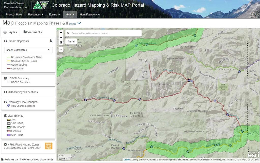
12 Flows Experienced & Modeled Modeled Discharges of the 100-yr Flood Event Fourmile Creek Emerson Gulch) Fourmile Creek Hwy 119) Gold Run mouth) Updated 1,969 cfs (56% decrease) Effective FEMA 4,470 cfs Updated 3,245 cfs (45% decrease) Effective FEMA 6,230 cfs Newly Modeled 610 cfs (new study) Effective FEMA NA Estimated Peak Discharges Experienced in 2013 Flood Fourmile Creek Emerson Gulch) Fourmile Creek Hwy 119) Gold Run mouth) 1,070 cfs (25-50 yr event) 2,300 cfs (~50 yr event) no estimate available


13 2013 Flood vs. 100-yr Mapped Floodplain
14 Roles and Responsibilities Federal Role (FEMA) Flood Risk Mapping Flood Risk Management Flood Insurance available to anyone State Role (CWCB) Community assistance Flood Risk Mapping Local Role (Boulder County) Adoption of floodplain mapping and code Flood risk mapping participation Ultimate Goal Protect Life, Health, & Safety

15 Timeline revisited Now Spring/ Summer 2018 Late 2018 Boulder County is reviewing the hydraulics and floodplain mapping FEMA will review the hydraulics and floodplain mapping, Boulder County to adopt floodplain as best available data Preliminary Flood Insurance Rate Maps issued 2019 FEMA Appeals Period 2021 FEMA Flood Insurance Rate Maps Become Effective all dates subject to change

16 Flood Fringe Floodway c Flood Fringe

17 Flood Fringe Floodway 500-year floodplain Some maps on your tables have draft layers in colors (not gray)
18 Hatched layers are same layer types as online; printed in color for ease of viewing Blue = Floodway Green = Flood Fringe Yellow = 500-year Floodplain

19 Solid color areas = current regulatory floodplains Letters = Map Zones


20 County Floodplain Remapping


21 Using the Map Review Website


22 Map Review Website
23 Map Review Website

24 How to comment How to comment Text box with alternative method

25 How to comment How to comment Text box with alternative method

26 How to comment How to comment Text box with alternative method

27 Resources button Upper right hand corner of webpage
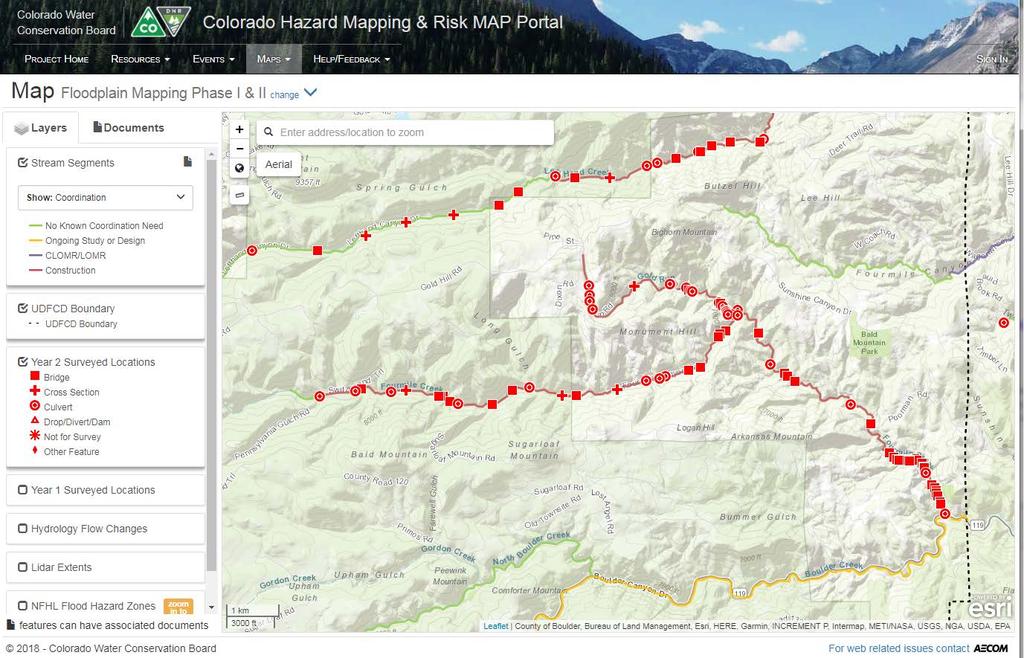
28 Draft Maps at the Tables What we d like to learn from your review: Structure locations accurate? Planned work? Topographic details Impacts to water flow Comments! Please include name & contact info on maps Use comment forms If you think the map needs revision, tell us WHY DEADLINE for comments for this area: FEBRUARY 4 th Remapping Point of Contact: Erin Cooper floodplainmapscomment@bouldercounty.org
Public Review of Draft Boulder County Floodplain Maps. January 10, 2017 Boulder, CO
 Public Review of Draft Boulder County Floodplain Maps January 10, 2017 Boulder, CO HOUSEKEEPING Sign-in sheet Newsletters & Flyers Locator Map (add your dot!) Tonight s Agenda 1. Introductions 2. Meeting
Planning Commission April 19, 2017 Erin Cooper, Floodplain Specialist Varda Blum, Floodplain Program Manger
 Public Hearing for Z-17-0001: Zoning Map Amendments to the Floodplain Overlay District & DC-17-0001: Land Use Code text amendments to the Floodplain regulations Planning Commission April 19, 2017 Erin
Floodplain Remapping
 Floodplain Remapping Floodplain Remapping Why remap the regulatory floodplain? More accurate maps means more effective floodplain management and safer communities. Who is remapping the regulatory floodplain?
Findings/Debrief Meeting September 9, CDOT R4 Headquarters Big Thompson Conference Room W 10 th St. Greeley, CO 80634
 Findings/Debrief Meeting September 9, 2016 CDOT R4 Headquarters Big Thompson Conference Room 10601 W 10 th St. Greeley, CO 80634 Discovery Review & Outcome May 25 Discovery Meeting Summary Summarize Data
Door County Floodplain Program Informational Meeting
 Door County Floodplain Program Informational Meeting Door County Land Use Services Department Wisconsin Department of Natural Resources January 15, 2018 Floodplain = Land affected by flood event with a
Community Officials Meeting. Plumas and Sierra County Physical Map Revision
 Community Officials Meeting Plumas and Sierra County Physical Map Revision March 6, 2014 Agenda Introductions/Sign In Project Scope Sierra Valley Flood Study (Plumas and Sierra Counties) North Yuba River
Abington Township Public Meeting
 Abington Township Public Meeting Flood Insurance Rate Map Update March 23, 2016 1 Meeting Agenda and Format Provide residents/property owners of Abington Township with information about the map update,
Council Communication February 21, 2017, Business Meeting
 Council Communication February 21, 2017, Business Meeting Second Reading of an ordinance amending the Flood Plain Corridor Lands Map FROM: Bill Molnar, Director of Community Development, bill.molnar@ashland.or.us
Taylor County, Florida Community Coordination and Outreach (CCO) Meeting
 Meeting") Taylor County, Florida Community Coordination and Outreach (CCO) Meeting Suwannee River Water Management District April 26, 2017 11:00AM to 12:00PM Taylor County Administration Building, 201 E. Green Street,
Taylor County, Florida Community Coordination and Outreach (CCO) Meeting Suwannee River Water Management District April 26, 2017 11:00AM to 12:00PM Taylor County Administration Building, 201 E. Green Street,
Updates to Maine Coastal Flood Insurance Rate Maps (FIRM s): What a Local Official Should Know. Presented by: Steve Johnson, P.E.
: What a Local Official Should Know. Presented by: Steve Johnson, P.E.") Updates to Maine Coastal Flood Insurance Rate Maps (FIRM s): What a Local Official Should Know Presented by: Steve Johnson, P.E. Town Engineer October 4, 2018 Introduction Federal Emergency Management
Updates to Maine Coastal Flood Insurance Rate Maps (FIRM s): What a Local Official Should Know Presented by: Steve Johnson, P.E. Town Engineer October 4, 2018 Introduction Federal Emergency Management
Piloting LAMP from Stream to Sea
 Piloting LAMP from Stream to Sea FEMA s New Analysis and Mapping Procedures for Non-Accredited Levee Systems Presented by: Eric Simmons, CFM Senior Engineer, FEMA Region IX Presentation Outline Levee Issues
Durham County Preliminary Flood Hazard Data Public Meeting. July 28, 2016
 Durham County Preliminary Flood Hazard Data Public Meeting July 28, 2016 Why Are We Here New flood hazard data has been released as Preliminary for Durham County Statutory Due Process for review/comments
Chapter 5 Floodplain Management
 Chapter 5 Floodplain Management Contents 1.0 Introduction... 1 2.0 Floodplain Management and Regulation... 1 2.1 City Code... 1 2.2 Floodplain Management... 1 2.3 Level of Flood Protection... 2 2.3.1 Standard
RichSmith_slate-FEMA_320x240.wmv.
 Nebraska DNR s role in the making of FEMA s Digital Flood Insurance Rate Maps Becky Groshens (grow-hands) & Shelley Schindler Important Terms: FIRM: Flood Insurance Rate Map FIS: Flood Insurance Study
REAL ESTATE FLOOD DISCLOSURE PROGRAM & FLOOD MAP INFORMATION SERVICES
 REAL ESTATE FLOOD DISCLOSURE PROGRAM & FLOOD MAP INFORMATION SERVICES Lisa Foster, CFM, Floodplain Coordinator ldfoster@pinellascounty.org January 26, 2018 Why are you here? Save your clients money on
Preliminary DFIRM Community Coordination (PDCC) Meeting Gilchrist & Levy Counties, FL. April 30, 2015
 Meeting Gilchrist & Levy Counties, FL. April 30, 2015") Preliminary DFIRM Community Coordination (PDCC) Meeting Gilchrist & Levy Counties, FL April 30, 2015 Agenda 1. Introductions 2. Study Process and Timeline 3. Overview of Preliminary Products 4. Overview
Preliminary DFIRM Community Coordination (PDCC) Meeting Gilchrist & Levy Counties, FL April 30, 2015 Agenda 1. Introductions 2. Study Process and Timeline 3. Overview of Preliminary Products 4. Overview
National Flood Insurance Program. Jennifer Gilbert, CFM, ANFI New Hampshire NFIP State Coordinator
 National Flood Insurance Program Jennifer Gilbert, CFM, ANFI New Hampshire NFIP State Coordinator What is the National Flood Insurance Program? Created by Congress in 1968 Participating Communities voluntarily
CRISP COUNTY, GEORGIA AND INCORPORATED AREAS
 CRISP COUNTY, GEORGIA AND INCORPORATED AREAS Community Name Community Number ARABI, CITY OF 130514 CORDELE, CITY OF 130214 CRISP COUNTY (UNINCORPORATED AREAS) 130504 Crisp County EFFECTIVE: SEPTEMBER 25,
Nassau County, Florida Consultation Coordination Officer (CCO) Meeting. February 24, 2016 Fernandina Beach, Florida
 Meeting. February 24, 2016 Fernandina Beach, Florida") Nassau County, Florida Consultation Coordination Officer (CCO) Meeting February 24, 2016 Fernandina Beach, Florida Agenda Introductions Coastal Study Update Study Process and Timeline Flood Insurance Implications
Nassau County, Florida Consultation Coordination Officer (CCO) Meeting February 24, 2016 Fernandina Beach, Florida Agenda Introductions Coastal Study Update Study Process and Timeline Flood Insurance Implications
Bullitt County, Kentucky Preliminary DFIRM Community Open House. October 8, 2014 Shepherdsville, Kentucky
 Bullitt County, Kentucky Preliminary DFIRM Community Open House October 8, 2014 Shepherdsville, Kentucky Meeting Agenda Introductions Overview of Preliminary DFIRMs Overview of Map Appeal Process Questions
Georgia Flood M.A.P. Program
 Georgia Flood M.A.P. Program Georgia Flood M.A.P. Program The Upper Chattahoochee River Basin Risk MAP Project Transitioning State Program to align with FEMA s Risk MAP Program Increase focus on risk assessment
St. Johns County, Florida Consultation Coordination Officer (CCO) Meeting. August 31, 2016 St. Augustine, Florida
 Meeting. August 31, 2016 St. Augustine, Florida") St. Johns County, Florida Consultation Coordination Officer (CCO) Meeting August 31, 2016 St. Augustine, Florida Agenda Introductions Coastal Study Update Study Process and Timeline Flood Insurance Implications
St. Johns County, Florida Consultation Coordination Officer (CCO) Meeting August 31, 2016 St. Augustine, Florida Agenda Introductions Coastal Study Update Study Process and Timeline Flood Insurance Implications
Duval County, Florida Consultation Coordination Officer (CCO) Meeting. January 25, 2017 Jacksonville, Florida
 Meeting. January 25, 2017 Jacksonville, Florida") Duval County, Florida Consultation Coordination Officer (CCO) Meeting January 25, 2017 Jacksonville, Florida Agenda Introductions Coastal Study Update Study Process and Timeline Flood Insurance Implications
Duval County, Florida Consultation Coordination Officer (CCO) Meeting January 25, 2017 Jacksonville, Florida Agenda Introductions Coastal Study Update Study Process and Timeline Flood Insurance Implications
Using Non-Regulatory RiskMAP Products in Floodplain Management. Ferrin Affleck, PE, CFM, Water Resources Engineer Project Manager Atkins
 Using Non-Regulatory RiskMAP Products in Floodplain Management Ferrin Affleck, PE, CFM, Water Resources Engineer Project Manager Atkins 1 Goal of this Presentation Inform Peak interest Stimulate creativity
Federal Emergency Management Agency
 Page 1 of 4 Issue Date: August 1, 2012 Effective Date: December 13, 2012 Case No.: 12-06-0595P LOMR-APP Washington, D.C. 20472 LETTER OF MAP REVISION DETERMINATION DOCUMENT COMMUNITY AND REVISION INFORMATION
Federal Emergency Management Agency
 Page 1 of 5 Issue Date: June 21, 2013 Follows Conditional Case No.: 04-06-A148R DETERMINATION DOCUMENT COMMUNITY COMMUNITY AND REVISION INFORMATION City of Irving Dallas County Texas FILL PROJECT DESCRIPTION
Tarrant County, TX Monthly Progress Report No. 33 (FEMA Contract No, HSFEHQ-09-D-0369) Task Order 01
 Task Order 01") Tarrant County, TX Monthly Progress Report No. 33 (FEMA Contract No, HSFEHQ-09-D-0369) Task Order 01 Period of Coverage: June 1, 2012 June 30, 2012 of Submittal: July 2, 2012 Submitted To: Ron Wanhanen
Tarrant County, TX Monthly Progress Report No. 33 (FEMA Contract No, HSFEHQ-09-D-0369) Task Order 01 Period of Coverage: June 1, 2012 June 30, 2012 of Submittal: July 2, 2012 Submitted To: Ron Wanhanen
Federal Emergency Management Agency
 Page 1 of 4 Issue Date: April 26, 2013 DETERMINATION DOCUMENT COMMUNITY AND REVISION INFORMATION PROJECT DESCRIPTION BASIS OF REQUEST City of Coppell Dallas County Texas FILL HYDRAULIC ANALYSIS NEW TOPOGRAPHIC
Bucks County, PA Flood Risk Review Meeting. November 2014
 Bucks County, PA Flood Risk Review Meeting November 2014 Agenda for Today Risk MAP Program overview Overview of non-regulatory Flood Risk Products and datasets Discuss mitigation action Technical overview
SECTION 9: MAPS AND DATA
 SECTION 9: MAPS AND DATA Contents 9.1. NFIP Maps and Data... 9-2 9.1.1. Adopting and enforcing NFIP floodplain maps and data... 9-2 9.1.2. Adopting and enforcing more restrictive data... 9-2 9.1.3. Annexations...
REAL ESTATE FLOOD DISCLOSURE PROGRAM & FLOOD MAP INFORMATION SERVICES
 REAL ESTATE FLOOD DISCLOSURE PROGRAM & FLOOD MAP INFORMATION SERVICES Agenda 10:30-12:00 Flood Disclosure Program 12:00-12:30 Lunch 12:30-1:30 Flood Map Service Center Lisa Foster, CFM, Floodplain Coordinator
SUPERHERO!!! Elevation Certificate. You are about to go from SURVEYOR 2/18/2019
 Karol L. Grove Licensed Professional Surveyor Certified Floodplain Manager Elevation Certificate No longer the Animal it used to be When are they needed??? You are about to go from SURVEYOR to SUPERHERO!!!
MONROE COUNTY, GEORGIA
 MONROE COUNTY, GEORGIA AND INCORPORATED AREAS Monroe County Community Name Community Number *CULLODEN, CITY OF 130543 FORSYTH, CITY OF 130359 MONROE COUNTY 130138 (UNINCORPORATED AREAS) *No Flood Hazard
Flood Risk Review (FRR) Meeting. Cumberland County, Pennsylvania Carlisle, Pennsylvania December 5, 2016
 Meeting. Cumberland County, Pennsylvania Carlisle, Pennsylvania December 5, 2016") Flood Risk Review (FRR) Meeting Cumberland County, Pennsylvania Carlisle, Pennsylvania December 5, 2016 Why are we here today? The Flood Insurance Study (FIS) report and Flood Insurance Rate Maps (FIRMs)
Flood Risk Review (FRR) Meeting Cumberland County, Pennsylvania Carlisle, Pennsylvania December 5, 2016 Why are we here today? The Flood Insurance Study (FIS) report and Flood Insurance Rate Maps (FIRMs)
Federal Emergency Management Agency
 Page 1 of 5 Issue Date: July 27, 2012 Effective Date: December 10, 2012 Case No.: 11-06-4512P Follows Conditional Case No.: 06-06-B789R LOMR-APP Federal Emergency Management Agency Washington, D.C. 20472
King County, WA DFIRM Update and Seclusion Process. Webinar June 14, 2016
 King County, WA DFIRM Update and Seclusion Process Webinar June 14, 2016 Agenda King County DFIRM Study History What is/has been done Process for moving forward Seclusion Seclusion mapping process Seclusion
Skagit County Flood Insurance Study Update. Ryan Ike, CFM FEMA Region 10
 Skagit County Flood Insurance Study Update Ryan Ike, CFM FEMA Region 10 Skagit County Flood Insurance Study Process Overview Process, Schedule, & Deliverables Base Flood Elevations, Modeling, & Levees
BUTTS COUNTY, GEORGIA AND INCORPORATED AREAS
 BUTTS COUNTY, GEORGIA AND INCORPORATED AREAS Butts County Community Name Community Number BUTTS COUNTY (UNICORPORATED AREAS) 130518 FLOVILLA, CITY OF 130283 JACKSON, CITY OF 130222 JENKINSBURG, TOWN OF
Using GISWeb to Determine Your Property s Flood Zone
 Using GISWeb to Determine Your Property s Flood Zone 1. In a new browser window, go to http://www.co.santacruz.ca.us/departments/geographicinformationsystemsgis.aspx 2. Click on GISWeb - GIS Mapping Application
Preliminary Work Map Release
 Coastal Mapping in New Jersey Preliminary Work Map Release Monmouth County, New Jersey June 14, 2013 Agenda Introduction and Purpose of Briefing Hurricane Sandy Advisory Base Flood Elevations Transitioning
210 W Canal Dr Palm Harbor, FL 34684
 Flood Analysis Memo Property Address In Partnership with: ** This property is within a high risk flood zone ** BFE = 6 ft This property is located in the FEMA designated high-risk zone, Zone AE - an area
HOLMES COUNTY, FLORIDA AND INCORPORATED AREAS
 HOLMES COUNTY, FLORIDA AND INCORPORATED AREAS Community Name Community Number BONIFAY, CITY OF 120116 ESTO, TOWN OF 120630 HOLMES COUNTY (UNINCORPORATED AREAS) 120420 NOMA, TOWN OF 120631 PONCE DE LEON,
Questions about the National Flood Insurance Program
 Questions about the National Flood Insurance Program Federal Emergency Management Agency (FEMA) Questions and Answers What is the National Flood Insurance Program (NFIP)? The NFIP is a Federal program
DECATUR COUNTY, GEORGIA AND INCORPORATED AREAS
 DECATUR COUNTY, GEORGIA AND INCORPORATED AREAS Community Name Community Number ATTAPULGUS, CITY OF 130541 BAINBRIDGE, CITY OF 130204 BRINSON, TOWN OF 130670 CLIMAX, CITY OF 130542 DECATUR COUNTY (UNINCORPORATED
FLOODPLAIN FAQ s. Last Update: June 2017
 FLOODPLAIN FAQ s Last Update: June 2017 What does FEMA stand for? Federal Emergency Management Agency - the operation of FEMA is to lead America to prepare for, prevent, respond to, and recover from disasters.
Flood Hazards and Flood Risk, the Impact of a Changing Climate
 Flood Hazards and Flood Risk, the Impact of a Changing Climate Sally A. McConkey, P.E. CFM, D. WRE. Illinois State Water Survey June 14, 2017 Topics ISWS Coordinated Hazard Assessment and Mapping Program
Mistakes on Elevation Certificates
 Mistakes on Elevation Certificates What is the Base Flood Elevation (BFE) & how do you determine it? FIRM Map Panel? Flood Insurance Study? o Profile Sheet o Floodway Data Chart o Stillwater Chart Community
Gail Moldovan-Trujillo, ACSR,CPIW Hagan Hamilton Insurance 2012 NFIP Agency of the year Flood Insurance Specialist & Consultant
 Gail Moldovan-Trujillo, ACSR,CPIW Hagan Hamilton Insurance 2012 NFIP Agency of the year Flood Insurance Specialist & Consultant Flood Insurance regulations continue to change at a very rapid pace, therefore
Federal Emergency Management Agency
 Page 1 of 5 Issue Date: October 16, 2014 Effective Date: March 2, 2015 Case No.: 14-09-2279P LOMR-APP Federal Emergency Management Agency Washington, D.C. 20472 LETTER OF MAP REVISION DETERMINATION DOCUMENT
Enough about me! Topics Covered
 About Me Worked in land surveying since 1997 Employed by the City of Orlando since 2006 City of Orlando City Surveyor since February 2015 Certified Floodplain Manager since 2015 Florida Licensed Surveyor,
Outreach Georgia Flood M.A.P. Program. GAFM Technical Conference Flood Risk Outreach and Policy Session
 Outreach Georgia Flood M.A.P. Program GAFM Technical Conference Flood Risk Outreach and Policy Session 7 th Annual Technical Conference, Lanier Islands March 29, 2012 Risk Communication Key Learnings People
City of San Mateo Flood Zone Update. North Shoreview Neighborhood Meeting June 18, 2014
 City of San Mateo Flood Zone Update North Shoreview Neighborhood Meeting June 18, 2014 Introductions Open Statement - Council Member Goethals Technical Presentation City Staff Closing Comments - Council
ASFPM Partnerships for Statewide Mitigation Actions. Alicia Williams GIS and HMP Section Manager, Amec Foster Wheeler June 2016
 ASFPM Partnerships for Statewide Mitigation Actions Alicia Williams GIS and HMP Section Manager, Amec Foster Wheeler June 2016 Summary The Concept Leveraging Existing Data and Partnerships to reduce risk
Consultation Coordination Officer (CCO) Meeting
 Meeting") Consultation Coordination Officer (CCO) Meeting Middle Brazos Lake Whitney Physical Map Revision Hill and McLennan Counties FEMA Region 6 Agenda National Flood Insurance Program Purpose of the Meeting
Consultation Coordination Officer (CCO) Meeting Middle Brazos Lake Whitney Physical Map Revision Hill and McLennan Counties FEMA Region 6 Agenda National Flood Insurance Program Purpose of the Meeting
Chapter 6 - Floodplains
 Chapter 6 - Floodplains 6.1 Overview The goal of floodplain management is to reduce the potential risks to both existing and future developments, and infrastructure, in the 100-year floodplain. Over the
The National Flood Insurance Program and Flood Insurance Rate Map for San Francisco. Presentation at Treasure Island Community Meeting
 The National Flood Insurance Program and Flood Insurance Rate Map for San Francisco Presentation at Treasure Island Community Meeting October 17, 2007 1 National Flood Insurance Program (NFIP) Overview
Barnes County Water Resource District
 Barnes County Water Resource District PO Box 306 Valley City, ND 58072 701-845-8508 April 14, 2014 MEETING MINUTES PRESENT MEMBERS: Chairperson Jerry Hieb; Manager Ken Evenson; Manager Bruce Anderson;
Chapter 7 Appendix B: National Flood Insurance Program Summary for Kaua'i County, 2015 Update
 Chapter 7 Appendix B: National Flood Insurance Program Summary for Kaua'i County, 2015 Update Topic Considerations Description INSURANCE SUMMARY STAFF RESOURCES How many NFIP policies are in Kaua i County?
Dealing With Unnumbered A Zones in Maine Floodplain Management
 Dealing With Unnumbered A Zones in Maine Floodplain Management The following is a list of acceptable methods that the State Floodplain Management Coordinator and the Federal Emergency Management Agency
PARK COUNTY, WYOMING AND INCORPORATED AREAS
 PARK COUNTY, WYOMING AND INCORPORATED AREAS Community Name Community Number CODY, CITY OF 560038 MEETEETSE, TOWN OF 560039 PARK COUNTY UNINCORPORATED AREAS 560085 POWELL, CITY OF 560040 June 18, 2010 Federal
Gallinas Watershed Program
 C O M M U N I T Y M E E T I N G April 5, 2016 Tonight s Agenda S C H E D U L E O F P R E S E N T A T I O N S Presentation: Gallinas Watershed Program Overview Questions and Answers Presentation: Upper
Federal Emergency Management Agency
 Page 1 of 6 Issue Date: October 24, 2012 Effective Date: March 7, 2013 Case No.: LOMR-APP DETERMINATION DOCUMENT COMMUNITY AND REVISION INFORMATION PROJECT DESCRIPTION BASIS OF REQUEST City of Lubbock
July 31, 2017 NFIP Flood Map Open House Flood Maps 101 Flood Mapping acronyms History of the NFIP Flood Mapping Updates Flood Insurance Fairhope,
 July 31, 2017 NFIP Flood Map Open House Flood Maps 101 Flood Mapping acronyms History of the NFIP Flood Mapping Updates Flood Insurance Fairhope, Alabama Flood Maps Fairhope Permitting Jurisdiction Coastal
Many of the changes to the NFIP were recently revised on March 21, 2014 by the Homeowner Flood Insurance Affordability Act of 2014.
 F l oodawa r e ne swe e k Ma r c h19-ma r c h25 2017 Below is a summary of the topics we will discuss today. On July 6, 2012, the Biggert-Waters Flood Insurance Reform Act of 2012 was passed by Congress
Now forget it all for the next 90 minutes.
 Karol L. Grove, PS Get ready to think outside of the box. Get ready to think about surveying, flood zones and flood insurance in a whole new light.. Think about everything you think you know about Elevation
Risk, Mitigation, & Planning
 Risk, Mitigation, & Planning Lessons from Flooding in the Houston Area Russell Blessing, Samuel Brody & Wesley Highfield CUMULATIVE FLOOD LOSS: 1972-2015 INSURED FLOOD LOSS: 1972-2015 THE HOUSTON-GALVESTON
Modernization, FEMA is Recognizing the connection between damage reduction and
 EXECUTIVE SUMMARY Every year, devastating floods impact the Nation by taking lives and damaging homes, businesses, public infrastructure, and other property. This damage could be reduced significantly
LOCAL OFFICIALS MEETING Lake Wausau Physical Map Revision MARATHON COUNTY, WISCONSIN FEBRUARY 9, 2017
 LOCAL OFFICIALS MEETING Lake Wausau Physical Map Revision MARATHON COUNTY, WISCONSIN FEBRUARY 9, 2017 Welcome & Introduction Michelle Staff Floodplain Management Policy Coordinator, WDNR Michelle.Staff@Wisconsin.gov
9/14/2012. Floodplain Basics the 100 year Flood. Columbus & Bartholomew County Flood Regulation Study Committee. Bartholomew County Floodplains
 Floodplain Basics the 100 year Flood Columbus & Bartholomew County Flood Regulation Study Committee 100-year Floodplain Purdue Land Use Team Video Seminar Series September 17, 2012 Floodway 1.2 inches
Floodplain Manager s Toolkit Unlocking the Hidden Potential of Floodplain Data for Your Community
 Floodplain Manager s Toolkit Unlocking the Hidden Potential of Floodplain Data for Your Community TFMA South Central Lunch Event San Antonio, TX June 12, 2014 Jessica D. Baker, PE, CFM, PMP Samuel Amoako-Atta,
Technical Memorandum 3.4 E Avenue NW Watershed Drainage Study. Appendix E Floodplain Impacts and Implications Memo
 Technical Memorandum 3.4 E Avenue NW Watershed Drainage Study Appendix E Floodplain Impacts and Implications Memo September 8, 2017 City of Cedar Rapids E Avenue Watershed Drainage Study Memo Date: Tuesday,
FEMA FLOOD MAPS Public Works Department Stormwater Management Division March 6, 2018
 FEMA FLOOD MAPS Public Works Department Stormwater Management Division March 6, 2018 Presentation Overview FEMA National Flood Insurance Program (NFIP) FEMA Community Rating System (CRS) Flood Insurance
Wyoming s Five-Year Floodplain Management Work Plan
 Wyoming s Five-Year Floodplain Management Work Plan Purpose: The purpose of this work plan is for the benefit of the Wyoming communities so that the risk and damages are minimized and environmental values
Analysis and Mapping Procedures for Non-Accredited Levees
 Analysis and Mapping Procedures for Non-Accredited Levees Proposed Approach for Public Review December 9, 2011 www.fema.gov/plan/prevent/fhm/rm_main.shtm 1 877 FEMA MAP Executive Summary Background This
Floodplain Management. City Council Work Session April 16, 2013
 Floodplain Management City Council Work Session April 16, 2013 1 Discussion Agenda Flood Insurance Rate Changes Community Rating System Recommendation Floodplain Ordinance Enhancements Modifications Public
Federal Emergency Management Agency
 Page 1 of 4 Issue ate: January 16, 2013 Effective ate: May 30, 2013 ETERMINATION OCUMENT COMMUNITY COMMUNITY AN REVISION INFORMATION City of Lawton Comanche County Oklahoma BRIGE CULVERT PROJECT ESCRIPTION
Erie County Flood Risk Review Meeting. January 18, 2018
 Erie County Flood Risk Review Meeting January 18, 2018 Agenda The value of updated flood maps for your community Review updated flood-risk data and important next steps in the Risk MAP process Increasing
Federal Emergency Management Agency
 Page 1 of 4 Issue ate: May 18, 2012 Follows Conditional Case No.: 08-06-1597R ETERMINATION OCUMENT COMMUNITY AN REVISION INFORMATION PROJECT ESCRIPTION BASIS OF REQUEST COMMUNITY Harris County Texas (Unincorporated
Middlesex County Timeline
 Community Coordination Meeting for Middlesex County, Connecticut Risk MAP Study November 9, 2011 Agenda Welcome and Introductions Project Timeline Coastal Flood Hazard Analysis Recap Public Review and
Cameron County, TX. Consultation Coordination Officer (CCO) Meeting. Please sign in (sheet at front of the room) Meeting will begin at 9:00
 Meeting. Please sign in (sheet at front of the room) Meeting will begin at 9:00") Cameron County, TX Consultation Coordination Officer (CCO) Meeting Please sign in (sheet at front of the room) Meeting will begin at 9:00 July 29, 2015 Lisa Jennings FEMA Region 6 Roles & Responsibilities
Cameron County, TX Consultation Coordination Officer (CCO) Meeting Please sign in (sheet at front of the room) Meeting will begin at 9:00 July 29, 2015 Lisa Jennings FEMA Region 6 Roles & Responsibilities
THE $64,000 FLOOD INSURANCE BILL
 THE $64,000 FLOOD INSURANCE BILL GEORGIA ASSOCIATION OF FLOODPLAIN MANAGERS 9 TH ANNUAL TECHNICAL CONFERENCE Patrick Gervais, PE, CFM A CASE STUDY IN FLOOD INSURANCE This is a true story that happened
PUTNAM COUNTY, GEORGIA
 PUTNAM COUNTY, GEORGIA AND INCORPORATED AREAS Community Name Community Number Eatonton, City of 130218 Putnam County 130540 (Unincorporated Areas) Putnam County Effective: September 26, 2008 FLOOD INSURANCE
All Hazard All Discipline Minutes
 All Hazard All Discipline Minutes October 27, 2016 11:30 am Gallatin County Coordination Center Agenda Present Patrick Lonergan, Kerri Strasheim; Mary Martin; Sean O Callaghan, Graver Johnson, Don Wilson,
AMENDMENTS TO CHAPTER 50: FLOODPLAIN DEVELOPMENT
 AMENDMENTS TO CHAPTER 50: FLOODPLAIN DEVELOPMENT PART I: 2018 FLOOD MAP IMPLEMENTATION PART II: STRATEGIES TO IMPROVE THE CITY S COMMUNITY RATING SYSTEM SCORE NATIONAL FLOOD INSURANCE PROGRAM (NFIP) CREATED
Memorandum. November 11,2010. Trinity River Corridor Project Committee Members: David
 Memorandum DATE November 11,2010 CITY OF DALLAS TO Trinity River Corridor Project Committee Members: David A. Neumann (Chairman) Vonciel Jones Steve Salazar (Vice-Chair) Delia Mayor Pro Tern Dwaine Caraway
Federal Flood Insurance Changes (National Flood Insurance Program NFIP)
") Federal Flood Insurance Changes (National Flood Insurance Program NFIP) Biggert-Waters (BW-12) Flood Insurance Reform Act 2012 HR 4348 Signed by the President on July 6, 2012 Public Works, Engineering
Federal Flood Insurance Changes (National Flood Insurance Program NFIP) Biggert-Waters (BW-12) Flood Insurance Reform Act 2012 HR 4348 Signed by the President on July 6, 2012 Public Works, Engineering
OTTAWA COUNTY AND SANDUSKY COUNTY COMMUNITY CONSULTATION OFFICERS (CCO) MEETING December 7, 2017
 MEETING December 7, 2017") OTTAWA COUNTY AND SANDUSKY COUNTY COMMUNITY CONSULTATION OFFICERS (CCO) MEETING December 7, 2017 TODAY S AGENDA The Value of Updated Flood Maps for Your Community Reviewing the Updated Flood Risk Data
OTTAWA COUNTY AND SANDUSKY COUNTY COMMUNITY CONSULTATION OFFICERS (CCO) MEETING December 7, 2017 TODAY S AGENDA The Value of Updated Flood Maps for Your Community Reviewing the Updated Flood Risk Data
Short Course on Floodplain Management
 Short Course on Floodplain Management A Reconnaissance Study on the Market Impacts on Elevated Homes in Known Floodplains City of Snoqualmie Case Study By Ron Throupe, Bob Freitag, Rhonda Montgomery Market
Plan Maintenance Procedures
 PLAN MAINTENANCE PLAN MAINTENANCE PROCEDURES... 1 MONITORING AND EVALUATION... 2 PLAN MONITORING... 2 PLAN EVALUATION... 2 UPDATING... 2 PLAN AMENDMENTS... 2 FIVE (5) YEAR REVIEW... 3 INCORPORATION...
REAL ESTATE FLOOD DISCLOSURE PROGRAM & FLOOD MAP INFORMATION SERVICES
 REAL ESTATE FLOOD DISCLOSURE PROGRAM & FLOOD MAP INFORMATION SERVICES Lisa Foster, CFM, Floodplain Coordinator ldfoster@pinellascounty.org January 26, 2018 Why are you here? Save your clients money on
Natchitoches Parish, Louisiana Flood Insurance Study Update Risk Analysis March 3, Shona Gibson Project Monitor, FEMA Region VI
 Natchitoches Parish, Louisiana Flood Insurance Study Update Risk Analysis Shona Gibson Project Monitor, FEMA Region VI Presentation Overview Introductions Why are we here? Levee Status and Opportunities
WASHINGTON COUNTY, KENTUCKY AND INCORPORATED AREAS
 WASHINGTON COUNTY, KENTUCKY AND INCORPORATED AREAS COMMUNITY NAME COMMUNITY NUMBER *MACKVILLE, CITY OF 210475 SPRINGFIELD, CITY OF 210220 WASHINGTON COUNTY (UNINCORPORATED AREAS) 210365 *WILLISBURG, CITY
Louisiana Transportation Conference
 Louisiana Transportation Conference February 10, 2009 Cindy N. O Neal, CFM THE NATIONAL FLOOD INSURANCE PROGRAM (NFIP) IN LOUISIANA If your home is located within the Special Flood Hazard Area There is
Federal Emergency Management Agency
 Page 1 of 6 Issue Date: May 13 2016 Case No.: Follows Conditional Case No.: 14-05-0595R DETERMINATION DOCUMENT COMMUNITY AND REVISION INFORMATION PROECT DESCRIPTION BASIS OF REQUEST COMMUNITY Village of
Federal Emergency Management Agency
 Page 1 of 5 Issue Date: October 19, 2012 Effective Date: March 4, 2013 Case No.: 12-06-3459P LOMR-APP Washington, D.C. 20472 LETTER OF MAP REVISION DETERMINATION DOCUMENT COMMUNITY AND REVISION INFORMATION
FREQUENTLY ASKED QUESTION ABOUT FLOODPLAINS Michigan Department of Environmental Quality
 FREQUENTLY ASKED QUESTION ABOUT FLOODPLAINS Michigan Department of Environmental Quality WHAT IS A FLOOD? The National Flood Insurance Program defines a flood as a general and temporary condition of partial
Herkimer County, New York Flood Hazard Mapping Status Report for Property Owners
 Herkimer County, New York Flood Hazard Mapping Status Report for Property Owners Herkimer County, New York Flood Hazard Mapping Status Report for Property Owners FLOOD INSURANCE Who Should Purchase Flood
JENKINS COUNTY, GEORGIA
 JENKINS COUNTY, GEORGIA AND INCORPORATED AREAS Community Name Community Number Jenkins County JENKINS COUNTY 130118 (UNINCORPORATED AREAS) MILLEN, CITY OF 130119 Revised: August 5, 2010 FLOOD INSURANCE
Flood Plain Management Services (FPMS) Program
 Program") Flood Plain Management Services (FPMS) Program 2016 Winter Stakeholder Partnering Forum March 2016 Mario Beddingfield, P.E., CFM Hydraulic Engineer/FPMS Program Manager H&H/Water Control Branch U.S. Army
Flood Plain Management Services (FPMS) Program 2016 Winter Stakeholder Partnering Forum March 2016 Mario Beddingfield, P.E., CFM Hydraulic Engineer/FPMS Program Manager H&H/Water Control Branch U.S. Army
What Was Updated in 2004 in Hennepin Countywide Maps?
 What Was Updated in 2004 in Hennepin Countywide Maps? Combined the city and township maps into one countywide index Done by USACE Mainly digital capture of old floodplain boundaries; some spots with shifts