Puget Sound Floodplains Mapping Project. Presented by CORE GIS March 18, 2011
|
|
|
- Gilbert Edwards
- 5 years ago
- Views:
Transcription


1 Puget Sound Floodplains Mapping Project Presented by CORE GIS March 18, 2011


2 Acknowledgements This project was conducted for the National Wildlife Federation, with funding from NWF and the Mountaineers Foundation
 concluded that NFIP jeopardizes the continued existence of salmon and orcas in Puget Sound and therefore must be modified.")
3 Project Background In 2004, NWF filed a successful lawsuit (NWF v. FEMA), asking the federal government to assess whether NFIP harms ESA-listed salmon. The resulting Biological Opinion 1 (BiOp) concluded that NFIP jeopardizes the continued existence of salmon and orcas in Puget Sound and therefore must be modified. The federal analysis estimates that if changes are not made, the NFIP program could be responsible for a 30% decline in wild Chinook in Puget Sound waters. 1 The Biological Opinion is officially titled Endangered Species Act Section 7 Consultation Final Biological Opinion and Magnuson-Stevens Fishery Conservation and Management Act Essential Fish Habitat Consultation: Implementation of the National Flood Insurance Program in the State of Washington Phase One Document Puget Sound Region, prepared by National Marine Fisheries Service Northwest Region, September 22, 2008.The BiOp can be downloaded at:
4 What did we set out to do? Help NWF ensure that the 2008 FEMA Floodplain Biological Opinion (BiOp) is implemented Produce maps and analyses for NWF to use in communicating floodplain issues to decision makers and the public
5 How did we do it? Maps Flood locations and severity Flood damages in dollars Repetitive loss, severe repetitive loss areas Floodplain loss over time and floods over time Development in floodplains over time Salmon habitat in floodplains Habitat in floodplains Hotspots Presence of PHS habitat polygons Presence of PHS points Percent impervious surface Number of structures
6 How did we do it? Analysis Statistics Flood costs Repetitive loss properties Floodplain delineation loss/change over time Assessed improvement value Floodplain Development Structures on parcels intersecting floodplains

7 Federal Flood Damage Public Assistance to Counties Total = $135,211,638

8 NFIP Payments by City, Total = $153,987,483


9 Repetitive Loss Properties Repetitive Loss Structure--An NFIP-insured structure that has had at least two paid flood losses of more than $1,000 each in any 10- year period since 1978.
 That has at least four NFIP claim payments (including building")
 For which at least two separate claims")

10 Severe Repetitive Loss Properties A Severe Repetitive Loss Property is one: (a) That has at least four NFIP claim payments (including building and contents) over $5,000 each, and the cumulative amount of such claims payments exceeds $20,000; or (b) For which at least two separate claims payments (building payments only) have been made with the cumulative amount of the building portion of such claims exceeding the market value of the building.

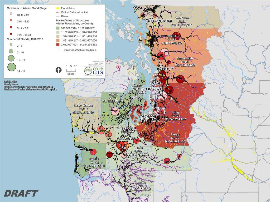
11 Flood Frequency and Heights Above Flood Stage

12
13 Measuring floodplain loss DFIRM maps are replacing the Q3 maps Where has floodplain been lost since the original delineations were made? Intersected Q3 and DFIRM to determine What stayed the same? Where was floodplain lost? Where was floodplain gained?

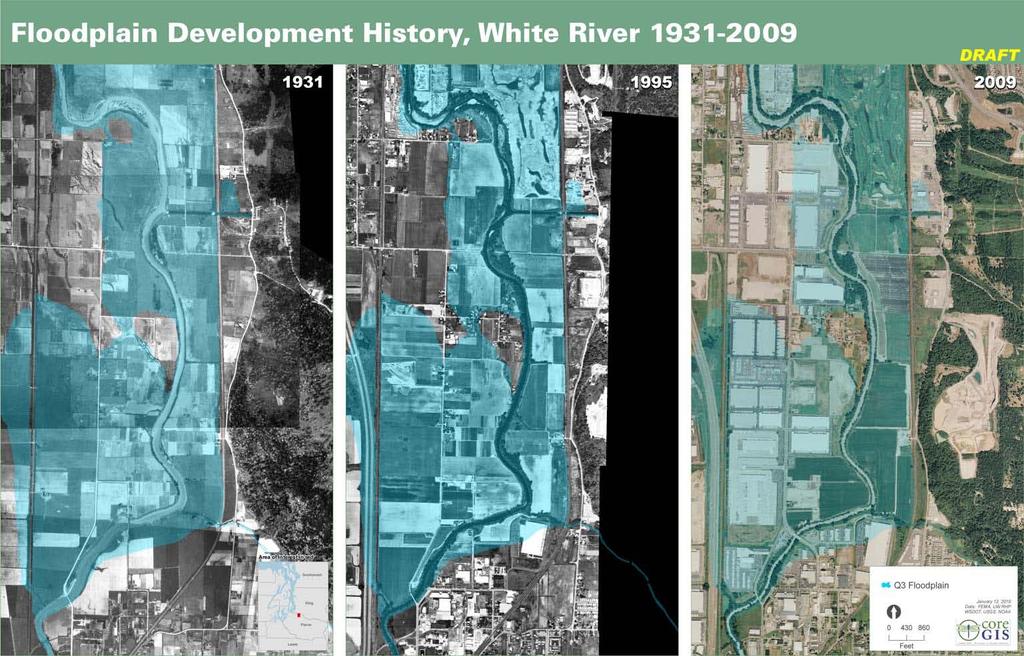
14 Floodplain loss over time Cedar River
15 Problems with measuring floodplain loss DFIRM updates still underway some counties Effective, some Intermediate, some Preliminary Changes may be actual floodplain loss; may be improvements in floodplain delineation methods The curse of the missing data acronyms! PMR: Physical Map Revision SOMA: Summary of Map Amendments LOMC: Letter of Map Change LOMR: Letter of Map Revision LOMA: Letter of Map Amendment CLOMR: Conditional Letter of Map Revision Etc Some are digital; most are not; all hard to find
16 Floodplain development over time, v1 Used NOAA CCAP to measure change in development between 1992 and 2006 This did not work out very well
17
18

19
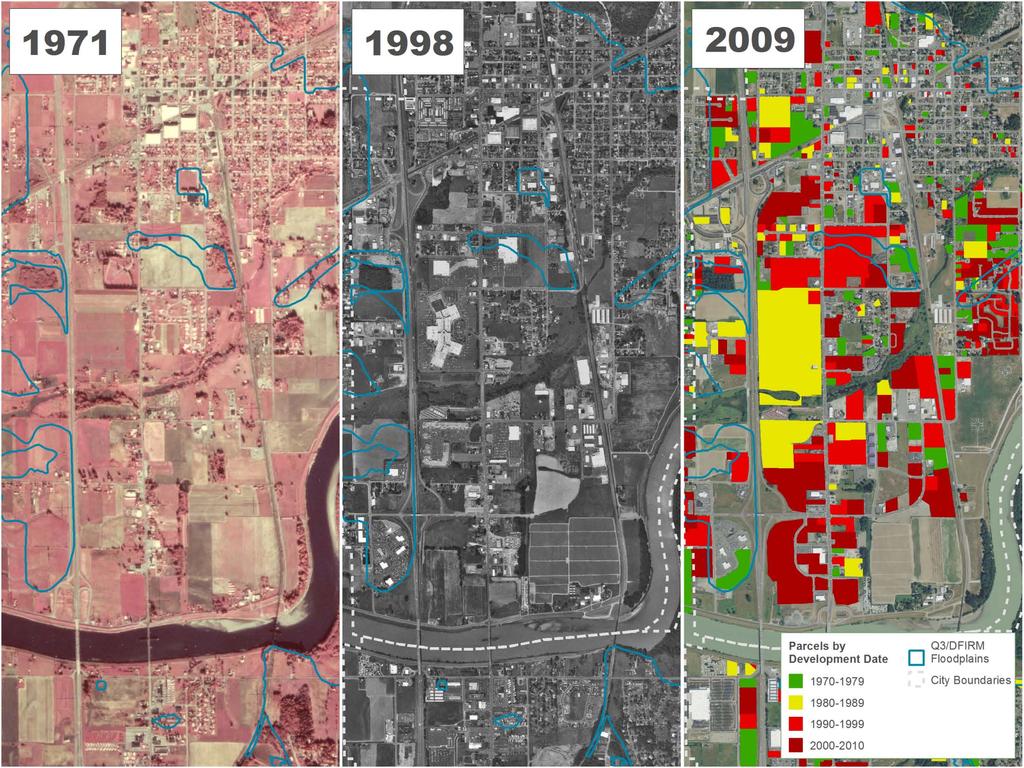
20 Floodplain development over time, v2 Using County Assessor data, indentified all parcels intersecting the union of Q3 and DFIRM floodplains across 8 counties Some counties provided data identifying whether or not a structure existed in parcels Where that information was absent, we used improvement value to represent a structure Using year built, mapped structures by decade Problems: parcel intersecting floodplain does not necessarily mean structure is located within floodplain; could be adjacent, uphill, etc Year built: ambiguity of effective vs actual
21
22 7,209 Structures
23 5,384 Structures

24 8,188 Structures
25 7,358 Structures
26 28,139 Structures

27

28

29

30
31

32

33
34
35
36 Assessed Improvement Value of All Properties Intersecting Floodplains Total Assessed Improvement Value of Properties Intersecting Floodplains 10/22/2010 County Number of Structures Market Improvement Value Grays Harbor 11,036 1,515,311,110 Thurston 5,095 1,374,376,950 Pierce 13,677 4,364,968,100 King 10,729 9,245,264,862 Snohomish 11,847 2,612,607,000 Skagit 11,279 2,401,292,127 Whatcom 8,822 1,861,419,216 Cowlitz 3,262 1,200,729,460 Kitsap 2, ,980,240 Mason 1 8,718 1,182,648,332 Lewis 2 5,932 1,363,250,703 Pacific 3 10,943 1,072,484,600 TOTAL 72,485 $ 23,375,239,365 1 Based on 2009 data 2 Based on 2007 data 3 Pacific county data should be consdired provisional due to the ambiguous nature of the assessed value field--there is only one field, called 'assessed' and it is unclear if this represents total assessed value, assessed land value, or assessed building value


37 Salmon Habitat
38 Hotspot Analysis 1. Percent impervious surface (from USGS NLCD) 2. Number of cells containing structures within a 10x10 cell moving window (cells containing a structure were coded 1, all others 0; the moving analysis window calculates a focal mean for each cell based on the surrounding 10x10 window) Resultant grid has a potential value range of 0-1, rescaled to using the formula ([GRID] - MYMIN) * ((NEWMAX - NEWMIN)/(MYMAX - MYMIN)) + NEWMIN 3. Percent of landscape covered by one or more priority habitat/species polygon within a 10x10 cell moving window 4. Number of cells containing PHS points within a 10x10 cell moving window (cells containing a PHS point were coded 1, all others 0; the moving analysis window calculates a focal mean for each cell based on the surrounding 10x10 window) Resultant grid has a potential value range of 0-1, rescaled to using the formula ([GRID] - MYMIN) * ((NEWMAX - NEWMIN)/(MYMAX - MYMIN)) + NEWMIN 5. The four grids all have a scale of 0-100; they were added together and divided by 4 to yield the final hotspot result.

39

40

41

42 Questions!
Regional Division Directors Regions I - X. Doug Bellomo, P.E. Director, Risk Analysis Division
 August 18, 2010 U.S. Department of Homeland Security 500 C Street SW Washington, DC 20472 FEMA MEMORANDUM FOR: Regional Division Directors Regions I - X FROM: SUBJECT: EFFECTIVE DATE: Doug Bellomo, P.E.
NMFS BiOp on FEMA s National Flood Insurance Program (NFIP) DeeAnn Kirkpatrick January 22, 2009
 DeeAnn Kirkpatrick January 22, 2009") NMFS BiOp on FEMA s National Flood Insurance Program (NFIP) DeeAnn Kirkpatrick January 22, 2009 Background Lawsuit - NWF v. FEMA Consultation started with Washington State, later Puget Sound area Species
NMFS BiOp on FEMA s National Flood Insurance Program (NFIP) DeeAnn Kirkpatrick January 22, 2009 Background Lawsuit - NWF v. FEMA Consultation started with Washington State, later Puget Sound area Species
FLOODPLAINS AND FLOOD RISK
 FLOODPLAINS AND FLOOD RISK A brief overview of changing management responsibilities The following article was originally published in The Water Report and is used with permission. Andrea Clark, of Downey
Improving Floodplain Management: Implications for Salmon, Public Safety, and Global Warming
 Improving Floodplain Management: Implications for Salmon, Public Safety, and Global Warming Dan Siemann National Wildlife Federation UW Water Center Seminar February 2, 2010 Why Does National Wildlife
Table 1: Federal, State and Local Government Rules applicable to LOMRs/CLOMRS submittal
 MnDNR LOMC Guide This document has been prepared by the Minnesota Department of Natural Resources floodplain staff and is intended to provide assistance with LOMR/CLOMR submittals. This information is
Storms Brewing in the National Flood Insurance Program: Understanding the Impacts on Your Community
 Storms Brewing in the National Flood Insurance Program: Understanding the Impacts on Your Community Molly Lawrence Van Ness Feldman LLP Washington, D.C Seattle, WA Why Are Floodplains Issue Important in
Floodplain Management 101: UNIT II. Maps & Flood Insurance Studies
 Floodplain Management 101: UNIT II Maps & Flood Insurance Studies Who is ASFPM? ASFPM stands for the Association of State Floodplain Managers A national organization of floodplain management professionals
2018 ECONOMIC IMPACTS OF CREDIT UNIONS IN WASHINGTON $352 MILLION. In direct member benefits $5.1 BILLION. total economic impact
 2018 ECONOMIC IMPACTS OF CREDIT UNIONS IN WASHINGTON $352 MILLION In direct member benefits $5.1 BILLION total economic impact ECONOMIC IMPACTS OF CREDIT UNIONS IN IDAHO, OREGON, AND WASHINGTON The Northwest
NFIP Mapping Issues. Wendy Lathrop, PLS, CFM. Cadastral Consulting, LLC
 NFIP Mapping Issues Cadastral Consulting, LLC NFIP Basic Objectives: Reduce the exposure to flood damages through the use of minimum standards for the placement and design of structures located in flood
HEALTH COVERAGE ENROLLMENT REPORT
 HEALTH COVERAGE ENROLLMENT REPORT JANUARY 2014 Table of Contents Website Statistics...1 Status of All Applications...2 by County...3 by Age...4 by Metal Level...6 by Gender...7 Family Size on Applications...8
Windermere Real Estate is proud to partner with Gardner Economics on this analysis of the Western Washington
 p r e pa r e d e x c l u s i v e ly f o r w i n d e r m e r e r e a l e s tat e w e s t e r n w a s h i n g t o n t h i r d q u a r t e r 2 014, V o l u m e X xv i i prepared exclusively for windermere
Repor. Capital. Finance. Pierce Transit Seeks Sales Tax Increase. Background. MVET repeal. Washington Research Council January 28, 2002
 page 1 Washington Capital Research Council Finance Repor eport Washington Research Council January 28, 2002 Pierce Transit Seeks Sales Tax Increase On February 5 th voters will be asked to approve a sales
HEALTH COVERAGE ENROLLMENT REPORT
 HEALTH COVERAGE ENROLLMENT REPORT FEBRUARY 2014 Table of Contents Website Statistics...1 Status of All Applications...2 by County...3 by Age...4 by Metal Level...6 by Gender...7 Family Size on Applications...8
Preliminary DFIRM Community Coordination (PDCC) Meeting Gilchrist & Levy Counties, FL. April 30, 2015
 Meeting Gilchrist & Levy Counties, FL. April 30, 2015") Preliminary DFIRM Community Coordination (PDCC) Meeting Gilchrist & Levy Counties, FL April 30, 2015 Agenda 1. Introductions 2. Study Process and Timeline 3. Overview of Preliminary Products 4. Overview
Preliminary DFIRM Community Coordination (PDCC) Meeting Gilchrist & Levy Counties, FL April 30, 2015 Agenda 1. Introductions 2. Study Process and Timeline 3. Overview of Preliminary Products 4. Overview
Planning Process---Requirement 201.6(b): An open public involvement process is essential to the development of an effective plan.
: An open public involvement process is essential to the development of an effective plan.") Section 3 Capability Identification Requirements Planning Process---Requirement 201.6(b): An open public involvement process is essential to the development of an effective plan. Documentation of the Planning
Section 3 Capability Identification Requirements Planning Process---Requirement 201.6(b): An open public involvement process is essential to the development of an effective plan. Documentation of the Planning
COMMUNITY CERTIFICATIONS
 OMB No. xxxxxxxx Expires: xxxxxxxx National Flood Insurance Program Community Rating System COMMUNITY CERTIFICATIONS D R A F T CRS COMMUNITY CERTIFICATIONS The following community certifications are part
Durham County Preliminary Flood Hazard Data Public Meeting. July 28, 2016
 Durham County Preliminary Flood Hazard Data Public Meeting July 28, 2016 Why Are We Here New flood hazard data has been released as Preliminary for Durham County Statutory Due Process for review/comments
FLOODPLAIN FAQ s. Last Update: June 2017
 FLOODPLAIN FAQ s Last Update: June 2017 What does FEMA stand for? Federal Emergency Management Agency - the operation of FEMA is to lead America to prepare for, prevent, respond to, and recover from disasters.
UNITED STATES DISTRICT COURT FOR THE WESTERN DISTRICT OF WASHINGTON ) ) ) ) ) ) ) ) ) ) ) ) ) )
 ) ) ) ) ) ) ) ) ) ) ) ) )") 1 1 1 1 1 1 1 0 1 JAN ERIK HASSELMAN (WSB # Seattle, WA 1 (0 - [FAX] hasselman@nwf.org JOHN F. KOSTYACK (D.C. Bar 1 MARY RANDOLPH SARGENT (D.C. Bar 0 0 1th Street, N.W., Suite 01 Washington, D.C. 00 (0
1 1 1 1 1 1 1 0 1 JAN ERIK HASSELMAN (WSB # Seattle, WA 1 (0 - [FAX] hasselman@nwf.org JOHN F. KOSTYACK (D.C. Bar 1 MARY RANDOLPH SARGENT (D.C. Bar 0 0 1th Street, N.W., Suite 01 Washington, D.C. 00 (0
Pinellas County Flood Map Information Service & Real Estate Disclosure Program Training January 26, 2017 COMMON FLOODPLAIN ACRONYMS
 FEMA ASFPM BFE CAV Pinellas County Flood Map Information Service & Real Estate Disclosure Program Training COMMON FLOODPLAIN ACRONYMS Federal Emergency Management Agency Association of State Floodplain
MT-1 Basics: A Comprehensive Overview of LOMAs and Discussion of Common Application Setbacks
 MT-1 Basics: A Comprehensive Overview of LOMAs and Discussion of Common Application Setbacks Introduction: Terminology MT-1s vs. MT-2s LOMAs vs. LOMRs What is a LOMC? Letters of Map Change (LOMCs) MT-1s
Thurston County, WA Flood Hazard Mitigation Plan Annual Progress Report CRS Activity 510
 Thurston County, WA Flood Hazard Mitigation Plan Annual Progress Report CRS Activity 510 Reporting Period: ctober 1, 2014 to September 30, 2015 Background: Thurston County developed a flood hazard mitigation
UNITED STATES DISTRICT COURT DISTRICT OF OREGON. Plaintiffs, Defendant. INTRODUCTION
 Daniel J. Rohlf, OSB 99006 rohlf@lclark.edu Pacific Environmental Advocacy Center 10015 S.W. Terwilliger Blvd. Portland, OR 97219-7768 Telephone: (503) 768-6707 Fax: (503) 768-6642 Andrew M. Hawley, OSB
INSTRUCTIONS FOR COMPLETING THE APPLICATION FORMS FOR CONDITIONAL LETTERS OF MAP REVISION AND LETTERS OF MAP REVISION
 INSTRUCTIONS FOR COMPLETING THE APPLICATION FORMS FOR CONDITIONAL LETTERS OF MAP REVISION AND LETTERS OF MAP REVISION GENERAL In 1968, the U.S. Congress passed the National Flood Insurance Act, which created
National Flood Insurance Program Final Nationwide Programmatic Environmental Impact Statement
 Final Nationwide Programmatic Environmental Impact Statement EXECUTIVE SUMMARY Action Agency: Federal Emergency Management Agency Cooperating Agency: U.S. Environmental Protection Agency September 2017
Enough about me! Topics Covered
 About Me Worked in land surveying since 1997 Employed by the City of Orlando since 2006 City of Orlando City Surveyor since February 2015 Certified Floodplain Manager since 2015 Florida Licensed Surveyor,
Requirements for Construction on Properties in the Special Flood Hazard Area (SFHA)
") Requirements for Construction on Properties in the Special Flood Hazard Area (SFHA) Rev 010915 The website for the IDNR to request the EFARA (Electronic Floodplain Analysis/Regulatory Assessment is found
Requirements for Construction on Properties in the Special Flood Hazard Area (SFHA) Rev 010915 The website for the IDNR to request the EFARA (Electronic Floodplain Analysis/Regulatory Assessment is found
Abington Township Public Meeting
 Abington Township Public Meeting Flood Insurance Rate Map Update March 23, 2016 1 Meeting Agenda and Format Provide residents/property owners of Abington Township with information about the map update,
When are non-integer solutions okay? Solution is naturally divisible. Solution represents a rate. Solution only for planning purposes
 Session # Page 1 When are non-integer solutions okay? Solution is naturally divisible Solution represents a rate Solution only for planning purposes When is rounding okay? Session # Page 2 The Challenges
UNITED STATES DISTRICT COURT FOR THE WESTERN DISTRICT OF WASHINGTON AT SEATTLE ) ) ) ) ) ) ) ) ) ) )
 ) ) ) ) ) ) ) ) ) )") THE HONORABLE RICARDO S. MARTINEZ 1 1 UNITED STATES DISTRICT COURT FOR THE WESTERN DISTRICT OF WASHINGTON AT SEATTLE NATIONAL WILDLIFE FEDERATION, v. Plaintiff, FEDERAL EMERGENCY MANAGEMENT AGENCY, Defendant.
THE HONORABLE RICARDO S. MARTINEZ 1 1 UNITED STATES DISTRICT COURT FOR THE WESTERN DISTRICT OF WASHINGTON AT SEATTLE NATIONAL WILDLIFE FEDERATION, v. Plaintiff, FEDERAL EMERGENCY MANAGEMENT AGENCY, Defendant.
INSTRUCTIONS FOR COMPLETING THE APPLICATION FORMS FOR CONDITIONAL LETTERS OF MAP REVISION AND LETTERS OF MAP REVISION
 INSTRUCTIONS FOR COMPLETING THE APPLICATION FORMS FOR CONDITIONAL LETTERS OF MAP REVISION AND LETTERS OF MAP REVISION GENERAL In 1968, the U.S. Congress passed the National Flood Insurance Act, which created
Middlesex County Timeline
 Community Coordination Meeting for Middlesex County, Connecticut Risk MAP Study November 9, 2011 Agenda Welcome and Introductions Project Timeline Coastal Flood Hazard Analysis Recap Public Review and
AMENDMENTS TO CHAPTER 50: FLOODPLAIN DEVELOPMENT
 AMENDMENTS TO CHAPTER 50: FLOODPLAIN DEVELOPMENT PART I: 2018 FLOOD MAP IMPLEMENTATION PART II: STRATEGIES TO IMPROVE THE CITY S COMMUNITY RATING SYSTEM SCORE NATIONAL FLOOD INSURANCE PROGRAM (NFIP) CREATED
N.C. Floodplain Mapping Program
 N.C. Floodplain Mapping Program Current Status and Update April 23, 2018 NCFMP Program Objectives Purpose: Develop, Maintain, and Disseminate current, accurate, digital flood hazard data for all of NC,
Planning Process---Requirement 201.6(b): An open public involvement process is essential to the development of an effective plan.
: An open public involvement process is essential to the development of an effective plan.") Section 3 Capability Identification Requirements Planning Process---Requirement 201.6(b): An open public involvement process is essential to the development of an effective plan. Documentation of the Planning
Section 3 Capability Identification Requirements Planning Process---Requirement 201.6(b): An open public involvement process is essential to the development of an effective plan. Documentation of the Planning
1515 Arapahoe Street Tower 1, Suite 530 Denver, CO Phone Fax MEMORANDUM. Date: July 9, 2014
 1515 Arapahoe Street Tower 1, Suite 530 Denver, CO 80202 Phone 303.294.0994 Fax 303.294.0979 Email ejleif@leif.net MEMORANDUM Date: July 9, 2014 To: Re: From: WSHIP Board of Directors Preliminary Calculation
Comparing HAZUS Flood Loss Estimates Across Hazard Identification Methods and Building Stock Inventory Data. Albion Township Dane County, Wisconsin
 Across Hazard Identification Methods and Building Stock Inventory Data Albion Township Dane County, Wisconsin Prepared for the Association of State Floodplain Managers September 1, 2010 Across Various
F E M A Mapping Changes. FEMA Mapping Changes. National Flood Insurance Program
 FEMA Mapping Changes National Flood Insurance Program 1 Welcome to FEMA Mapping Changes! We will get started in a few minutes. Meanwhile, let s perform a warm up exercise. 2 1 Training Agenda Section 1-
Regional Healthcare Hazard Vulnerability Assessment
 Regional Healthcare Hazard Vulnerability Assessment Prepared by: The Northwest Healthcare Response Network June 5, 2017 2017 Northwest Healthcare Response Network. Regional Healthcare Hazard Vulnerability
$159 million. $2.2 billion Oregon Credit Union Impacts. direct benefits to Oregon credit union consumers. total economic impact in Oregon
 $159 million direct benefits to Oregon credit union consumers $2.2 billion total economic impact in Oregon 2016 Oregon Credit Union Impacts Economic Impacts of Credit Unions in Oregon and Washington Northwest
1331 Seventeenth Street, Suite 350 Denver, CO Phone Fax MEMORANDUM. Date: October 16, 2017
 1331 Seventeenth Street, Suite 350 Denver, CO 80202 Phone 303.294.0994 Fax 303.294.0979 Email ejleif@leif.net MEMORANDUM Date: October 16, 2017 To: Re: From: WSHIP Board of Directors Calculation of 2018
Kentucky Risk MAP It s not Map Mod II
 Kentucky Risk MAP It s not Map Mod II Risk Mapping Assessment and Planning Carey Johnson Kentucky Division of Water carey.johnson@ky.gov What is Risk MAP? Risk Mapping, Assessment, and Planning (Risk MAP)
Bullitt County, Kentucky Preliminary DFIRM Community Open House. October 8, 2014 Shepherdsville, Kentucky
 Bullitt County, Kentucky Preliminary DFIRM Community Open House October 8, 2014 Shepherdsville, Kentucky Meeting Agenda Introductions Overview of Preliminary DFIRMs Overview of Map Appeal Process Questions
Attachment B. King County Flood Control Zone District Work Program
 Attachment B King County Flood Control Zone District Work Program The King County Flood Control Zone District work program is comprised of two major categories: Programmatic Work Program o Flood Preparedness,
Flood Plain Management Annual Progress Report September 2014
 Flood Plain Management Annual Progress Report September 2014 Flood Plains in the City of Santa Cruz The City of Santa Cruz flood plains encompass the low-lying areas along the San Lorenzo River through
All inquiries concerning the charges for title insurance and forms in this manual should be directed to the following:
 This manual is for the use of Stewart Title Guaranty Company's ( Stewart or Underwriter ) Title Insurance Policy Issuing Attorneys, Agents, and Offices. Any other use or reproduction of this manual is
STEWART TITLE GUARANTY COMPANY
 STEWART TITLE GUARANTY COMPANY RATE MANUAL FOR TITLE INSURANCE ON RESIDENTIAL PROPERTY IN THE STATE OF WASHINGTON Effective July 1, 2016 Rate Filing # 2016-01 This manual is for the use of Stewart Title
Chapter 5 Floodplain Management
 Chapter 5 Floodplain Management Contents 1.0 Introduction... 1 2.0 Floodplain Management and Regulation... 1 2.1 City Code... 1 2.2 Floodplain Management... 1 2.3 Level of Flood Protection... 2 2.3.1 Standard
What Was Updated in 2004 in Hennepin Countywide Maps?
 What Was Updated in 2004 in Hennepin Countywide Maps? Combined the city and township maps into one countywide index Done by USACE Mainly digital capture of old floodplain boundaries; some spots with shifts
LOCAL OFFICIALS MEETING Lake Wausau Physical Map Revision MARATHON COUNTY, WISCONSIN FEBRUARY 9, 2017
 LOCAL OFFICIALS MEETING Lake Wausau Physical Map Revision MARATHON COUNTY, WISCONSIN FEBRUARY 9, 2017 Welcome & Introduction Michelle Staff Floodplain Management Policy Coordinator, WDNR Michelle.Staff@Wisconsin.gov
THE FEDERAL EMERGENCY MANAGEMENT AGENCY. Letters of Map Change Kristen Martinenza, P.E., CFM FEMA Region IV
 THE FEDERAL EMERGENCY MANAGEMENT AGENCY Letters of Map Change Presented by: Kristen Martinenza, P.E., CFM FEMA Region IV 1 NATIONAL FLOOD INSURANCE ACT OF 1968 At the start of the program, there was not
October 2015 Approved Medicare Supplement (Medigap) Plans By federal law, the high-deductible plan F has a $2,180 deductible for the year 2015
 Plans By federal law, the high-deductible plan F has a $2,180 deductible for the year 2015") By federal law, the high-deductible plan F has a $2,180 deductible for the year 2015 People who: Have a Medigap plan B through N can join any Medigap plan except Plan A. Have Medigap Plan A can join any
By federal law, the high-deductible plan F has a $2,180 deductible for the year 2015 People who: Have a Medigap plan B through N can join any Medigap plan except Plan A. Have Medigap Plan A can join any
FEMA FLOOD MAPS Public Works Department Stormwater Management Division March 6, 2018
 FEMA FLOOD MAPS Public Works Department Stormwater Management Division March 6, 2018 Presentation Overview FEMA National Flood Insurance Program (NFIP) FEMA Community Rating System (CRS) Flood Insurance
Kevin Wagner Maryland Department of the Environment
 Kevin Wagner Maryland Department of the Environment Topics Overview of the National Flood Insurance Program (NFIP) Mapping Regulations Insurance Mitigation Community Rating System (CRS) Questions Know
Chapter 7 Appendix B: National Flood Insurance Program Summary for Kaua'i County, 2015 Update
 Chapter 7 Appendix B: National Flood Insurance Program Summary for Kaua'i County, 2015 Update Topic Considerations Description INSURANCE SUMMARY STAFF RESOURCES How many NFIP policies are in Kaua i County?
JAXGIS FEMA Flood Hazard Mapping -- Frequently Asked Questions
 Flood Hazard Zone Designations Summary Zones starting with the letter 'A' (for instance, Zone A, Zone AE, Zone AH, Zone AO) denote a Special Flood Hazard Area, which can also be thought of as the 100-year
Bringing. Washington Affordable Housing Report
 Bringing Washington Home 21 Affordable Housing Report Bringing Washington Home: Affordable Housing Report 21 Introduction to the Data In this year s Affordable Housing Report, we see a picture of the economic
Updates to Maine Coastal Flood Insurance Rate Maps (FIRM s): What a Local Official Should Know. Presented by: Steve Johnson, P.E.
: What a Local Official Should Know. Presented by: Steve Johnson, P.E.") Updates to Maine Coastal Flood Insurance Rate Maps (FIRM s): What a Local Official Should Know Presented by: Steve Johnson, P.E. Town Engineer October 4, 2018 Introduction Federal Emergency Management
Updates to Maine Coastal Flood Insurance Rate Maps (FIRM s): What a Local Official Should Know Presented by: Steve Johnson, P.E. Town Engineer October 4, 2018 Introduction Federal Emergency Management
Role of the Local Floodplain Administrator
 2/22/2016 Role of the Local Floodplain Administrator Marsha Hilmes-Robinson Floodplain Administrator City of Fort Collins, Colorado mhilmesrobinson@fcgov.com 1 Partnership Engineer/Architect/ Contractor
July 2016 Approved Medicare Supplement (Medigap) Plans By federal law, the high-deductible plan F has a $2,180 deductible for the year 2016
 Plans By federal law, the high-deductible plan F has a $2,180 deductible for the year 2016") By federal law, the high-deductible plan F has a $2,180 deductible for the year 2016 People who: Have a Medigap plan B through N can join any Medigap plan except Plan A. Have Medigap Plan A can join any
By federal law, the high-deductible plan F has a $2,180 deductible for the year 2016 People who: Have a Medigap plan B through N can join any Medigap plan except Plan A. Have Medigap Plan A can join any
Vision to Action: Creating and Using a Flood Risk Assessment for Identifying Mitigation Options
 Vision to Action: Creating and Using a Flood Risk Assessment for Identifying Mitigation Options Lisa Graff, CFM, GISP Clayton Ballerine, CFM Brad McVay, CFM, GISP University of Illinois Prairie Research
Washington State Business Employment Dynamics Second Quarter 2017
 Quarterly Census of Employment and Wages Business Employment Dynamics April to June 2017 Washington State Business Employment Dynamics Second Quarter 2017 Figure 1 Net change in jobs, seasonally adjusted
Modernization, FEMA is Recognizing the connection between damage reduction and
 EXECUTIVE SUMMARY Every year, devastating floods impact the Nation by taking lives and damaging homes, businesses, public infrastructure, and other property. This damage could be reduced significantly
Suwannee River Water Management District
 Suwannee River Water Management District FEMA Flood Map Modernization Program 5-Year Business Plan FY 2004-2009 Prepared By: URS Corporation Dewberry Water Resource Associates February 14, 2004 Revised
SUPERHERO!!! Elevation Certificate. You are about to go from SURVEYOR 2/18/2019
 Karol L. Grove Licensed Professional Surveyor Certified Floodplain Manager Elevation Certificate No longer the Animal it used to be When are they needed??? You are about to go from SURVEYOR to SUPERHERO!!!
$618 million. $8.4 billion Economic Impacts of Credit Unions. direct benefits to credit union consumers. total economic impact
 $618 million direct benefits to credit union consumers $8.4 billion total economic impact 2017 Economic Impacts of Credit Unions in Idaho, Oregon, and Washington Economic Impacts of Credit Unions in Idaho,
RichSmith_slate-FEMA_320x240.wmv.
 Nebraska DNR s role in the making of FEMA s Digital Flood Insurance Rate Maps Becky Groshens (grow-hands) & Shelley Schindler Important Terms: FIRM: Flood Insurance Rate Map FIS: Flood Insurance Study
3.1 STATUS DETERMINATION CRITERIA
 Agenda Item E.2 Attachment 1 March 2016 EXCERPTS FROM PACIFIC COAST SALMON FISHERY MANAGEMENT PLAN UPDATED THROUGH AMENDMENT 18 The entire Salmon FMP may be viewed at: http://www.pcouncil.org/salmon/fishery-managementplan/current-management-plan/
King County Flood Control District 2015 Work Program
 Attachment A 2015 Work Plan 10-24-14 King County Flood Control District 2015 Work Program The District work program is comprised of three categories: district oversight and policy development, operations,
A Flood of Questions:
 Oregon Law Institute of Lewis & Clark Law School A Flood of Questions: Integrating Floodplain Management and Salmon Conservation Co-sponsored by CRITFC and OLI OLI We raise the Bar Friday, November 7,
Executive Summary Levee Engineering Assessments September 26, 2014
 Executive Summary s September 26, 2014 Purpose Multnomah County Drainage District (MCDD), the agency responsible for managing the Columbia Corridor levee system, received notification that in August of
Chehalis River Basin. Reducing Flood Damage and Restoring Aquatic Species. 9:00 a.m. October 5, 2018 Thurston Regional Planning Council
 Chehalis River Basin Reducing Flood Damage and Restoring Aquatic Species 9:00 a.m. October 5, 2018 Thurston Regional Planning Council Today s Presentation... Provide update, encourage discussion. Key messages...
Repetitive Loss Area Revisit # 6 Walter Road Area Jefferson Parish
 Repetitive Loss Area Revisit # 6 Walter Road Area Jefferson Parish www.floodhelp.uno.edu Supported by FEMA Acknowledgement The compilation if this report was managed by Erin Patton, CFM, a UNO-CHART Research
Changes Coming to the National Flood Insurance Program What to Expect. Impact of changes to the NFIP under Section 205 of the Biggert-Waters Act
 Changes Coming to the National Flood Insurance Program What to Expect Impact of changes to the NFIP under Section 205 of the Biggert-Waters Act Flood Risk Flood risks and the costs of flooding Weather
Georgia Flood M.A.P. Program Risk MAP Plenary Session GAFM 2011
 Georgia Flood M.A.P. Program Risk MAP Plenary Session GAFM 2011 Collis Brown, Georgia DNR March 24, 2011 GA Flood Map Modernization Responsible for end-to-end production Developed aggressive outreach program
Floodplain Manager s Toolkit Unlocking the Hidden Potential of Floodplain Data for Your Community
 Floodplain Manager s Toolkit Unlocking the Hidden Potential of Floodplain Data for Your Community TFMA South Central Lunch Event San Antonio, TX June 12, 2014 Jessica D. Baker, PE, CFM, PMP Samuel Amoako-Atta,
Justification for Floodplain Regulatory Standards in Illinois
 Justification for Floodplain Regulatory Standards in Illinois Office of Water Resources Issue Paper April, 2015 Proactive Illinois floodplain and floodway regulatory standards have prevented billions of
G318 Local Mitigation Planning Workshop. Module 2: Risk Assessment. Visual 2.0
 G318 Local Mitigation Planning Workshop Module 2: Risk Assessment Visual 2.0 Unit 1 Risk Assessment Visual 2.1 Risk Assessment Process that collects information and assigns values to risks to: Identify
CHICAGO TITLE INSURANCE COMPANY
 CHICAGO TITLE INSURANCE COMPANY TITLE INSURANCE RATES AND CHARGES FOR THE STATE OF WASHINGTON EFFECTIVE: June 19, 2013 (Unless Otherwise Noted Herein) RATING SCHEDULE This Schedule of rates shall apply
Community Officials Meeting. Plumas and Sierra County Physical Map Revision
 Community Officials Meeting Plumas and Sierra County Physical Map Revision March 6, 2014 Agenda Introductions/Sign In Project Scope Sierra Valley Flood Study (Plumas and Sierra Counties) North Yuba River
Property Tax Limitation in Washington State
 POLICY BRIEF Property Tax Limitation in Washington State By Paul Guppy Vice President for Research August 2003 P.O. Box 3643, Seattle, WA 98124-3643 888-WPC-9272 www.washingtonpolicy.org Property Tax Limitation
Community Coordination Meeting Sagadahoc County, Maine
 Community Coordination Meeting Sagadahoc County, Maine Risk MAP Study April 2, 2014 Agenda Welcome and Introductions Project Timeline Flood Hazard Analysis Recap Flood Risk Products Action: Hazard Mitigation
Bonnie Shorin. Currently - Program Analyst with the Na8onal Marine Fisheries Service.
 Bonnie Shorin Currently - Program Analyst with the Na8onal Marine Fisheries Service. 11 years at Washington State Department of Ecology - Shoreline Management, Coastal Zone Management, Sec8on 401 of the
LIABILITY EXCESS OF LOSS REINSURANCE AGREEMENT ENDORSEMENT. between. Washington Counties Risk Pool, ("Reinsured") and
 and") ENDORSEMENT between Washington Counties Risk Pool, ("Reinsured") and Berkley Insurance Company ("Reinsurer"). This endorsement forms a part of the Agreement to which it is attached. Please read it carefully.
ENDORSEMENT between Washington Counties Risk Pool, ("Reinsured") and Berkley Insurance Company ("Reinsurer"). This endorsement forms a part of the Agreement to which it is attached. Please read it carefully.
Environmental Review and Disaster Recovery
 Environmental Review and Disaster Recovery Welcome & Speakers Session Objectives Identify the importance of Environmental Reviews Identify tips for understanding post disaster Environmental Laws Determine
MITIGATION BANK ENABLING INSTRUMENT Table of Contents
 MITIGATION BANK ENABLING INSTRUMENT Table of Contents RECITALS... 1 AGREEMENT... 3 Section I: Purpose and Authorities... 3 A. Purpose... 3 B. Authorities... 3 Section II: Definitions... 5 Section III:
Monthly Employment Report
 Washington 5.8% United States 4.9% Seasonally adjusted Employment estimates in this report are generated by the U.S. Bureau of Labor Statistics (BLS). Monthly employment estimates are subject to revision
Guidelines and Specifications for Flood Hazard Mapping Partners. Introduction
 Introduction INT.1 Purpose and Scope of Document The Federal Emergency Management Agency (FEMA), as the agency responsible for administration of the National Flood Insurance Program (NFIP), conducts flood
Washington Health Benefit Exchange
 Washington Health Benefit Exchange HEALTHCARE REFORM SEMINAR November 25th, 2013 ACA INFORMATIONAL SESSION FOR SMALL BUSINESS OWNERS The Affordable Care Act Exchange Basics Today s Agenda Exchange Functions
King County Flood Control District Flood Risk Reduction Work Program and Accomplishments
 King County Flood Control District Flood Risk Reduction Work Program and Accomplishments Brian Murray Water and Land Resources Division April 26, 2016 Department of Natural Resources and Parks Water and
Skagit County Flood Insurance Study Update. Ryan Ike, CFM FEMA Region 10
 Skagit County Flood Insurance Study Update Ryan Ike, CFM FEMA Region 10 Skagit County Flood Insurance Study Process Overview Process, Schedule, & Deliverables Base Flood Elevations, Modeling, & Levees
Schedule of Rates and Fees State of Washington General Rating Schedule C
 Schedule of Rates and Fees State of Washington General Rating Schedule C Effective Date: April 1st, 2014 This Schedule of Rates shall apply in computing charges for title insurance with respect to all
10526 Bermuda Isle Dr. Tampa, FL 33647
 Flood Analysis Memo Property Address In Partnership with: ** This property is NOT within a high-risk flood zone ** This property is located in a FEMA low-risk zone designated as Zone X - an area of minimal
Taylor County, Florida Community Coordination and Outreach (CCO) Meeting
 Meeting") Taylor County, Florida Community Coordination and Outreach (CCO) Meeting Suwannee River Water Management District April 26, 2017 11:00AM to 12:00PM Taylor County Administration Building, 201 E. Green Street,
Taylor County, Florida Community Coordination and Outreach (CCO) Meeting Suwannee River Water Management District April 26, 2017 11:00AM to 12:00PM Taylor County Administration Building, 201 E. Green Street,
Federal Flood Insurance Changes (National Flood Insurance Program NFIP)
") Federal Flood Insurance Changes (National Flood Insurance Program NFIP) Biggert-Waters (BW-12) Flood Insurance Reform Act 2012 HR 4348 Signed by the President on July 6, 2012 Public Works, Engineering
Federal Flood Insurance Changes (National Flood Insurance Program NFIP) Biggert-Waters (BW-12) Flood Insurance Reform Act 2012 HR 4348 Signed by the President on July 6, 2012 Public Works, Engineering
AGENDA. Floodplain Manager s Toolkit Unlocking the Hidden Potential of Floodplain Data for Your Community
 Floodplain Manager s Toolkit Unlocking the Hidden Potential of Floodplain Data for Your Community TFMA Spring Conference May 29, 2014 Jessica D. Baker, PE, CFM, PMP Samuel Amoako-Atta, GISP, CFM Eric Hajek,
Changing Course: Why protecting floodplains is good for people and wildlife. National Wildlife Federation 2013
 Changing Course: Why protecting floodplains is good for people and wildlife National Wildlife Federation 2013 Protecting and restoring floodplains is one of the most important things we can do to recover
34 Years of Brighter Futures
 207 Impact Report 983-207 34 Years of Brighter Futures Washington State Housing Finance Commission We welcome the opportunity to tell you more about our programs and how they work to make your community
COLLIER COUNTY FLOODPLAIN MANAGEMENT
 COLLIER COUNTY FLOODPLAIN MANAGEMENT FREQUENTLY ASKED QUESTIONS The following information is based on common questions from the public. If you have a specific question or need further information, please
Monthly Employment Report
 Washington 4.5% United States 4.1% Seasonally adjusted Employment estimates in this report are generated by the U.S. Bureau of Labor Statistics (BLS). Monthly employment estimates are subject to revision