Understanding Risk Balkans Conference, Belgrade, Serbia, September 17-19, 2018
|
|
|
- Rafe Lucas
- 5 years ago
- Views:
Transcription
ve on the Assessment and Management of Floods pros and cons Janusz Zaleski OVFPCU")
1 Understanding Risk Balkans Conference, Belgrade, Serbia, September 17-19, 2018 Implementa)on in Poland of the European Union Flood Direc)ve on the Assessment and Management of Floods pros and cons Janusz Zaleski OVFPCU Wroclaw/IMGW/WARR
 Source: Flood risk and environmental vulnerability, EEA Report")
2 Reported flood phnenomena (numer of floods per km) per country (since 1980) Source: Flood risk and environmental vulnerability, EEA Report 1/2016
tu)ons were affected; flood losses approx. $3.5 billion CZECH REPUBLIC flood losses approx. 550 million GERMANY flood losses approx.")
3 The 1997 flood Odra & Vistula river POLAND: 54 human lives; 680,000 homes, 143,000 enterprises, 4,000 educa)on, culture and health care ins)tu)ons were affected; flood losses approx. $3.5 billion CZECH REPUBLIC flood losses approx. 550 million GERMANY flood losses approx. 330 million


4 1997 Flood on Odra River, Wroclaw, Poland

5 Flood on Warta River, a polder at Noteć River mouth Phot. T.Konieczny
6 European Direc)ve on the Assessment and Management of Floods crea6on, within the territory of the European Community, a uniform basis for taking ac6on designed to reduce the risk of flooding harmonised with the WFD 2000/60/EC based on DPSIR (Driver- Pressure- State- Impact- Response) analysis adequate level protec6on for each basin investment ac6vi6es should be linked to spa6al development planning and preven6ve risk management Member States prepare flood maps, indica)ve flood damage maps and flood management plans at the basin level & for coastal zones
7 European Direc)ve on the Assessment and Management of Floods implementa)on schedule Member states will do: By nd preliminary flood risk assessment & specific requirements on climate change By nd flood hazard maps and flood risk maps By nd flood risk management plans & specific requirement on climate change In interna)onal basins: Ø coordina)on between MS Ø problems are not passed from one country to another downstream Ø all stakeholders must bo given opportunity to par6cipate ac6vely in the development of the flood risk management plans Ø risk assessments, maps & plans must be available to public These 3 steps are to be repeated on a 6- years cycle
cipa)on/map_mc/countries/images/poland.jpg")
8 IMPLEMENTATION EU FLOOD DIRECTIVE IN POLAND Source: hip://ec.europa.eu/environment/water/par)cipa)on/map_mc/countries/images/poland.jpg
 75 milllion EURO EU co- financed")
9 IT System for country protec)on against extraordinary hazards Informatyczny System Osłony Kraju przed nadzwyczajnymi zagrożeniami (ISOK) 75 milllion EURO EU co- financed project

 Other hazard maps (5)")

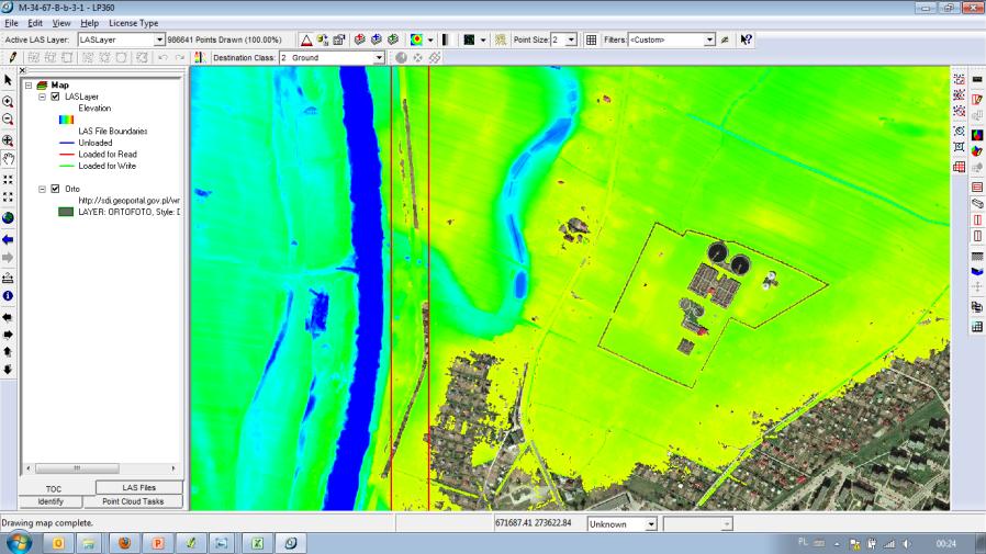
10 Main components of the ISOK System Digital Terrain Model of LIDAR data Hydrographic Map of Poland 1: ISOK IT SYSTEM Orthophotomaps ( km 2 ) Flood hazard maps Flood risk maps Meteorogical hazard maps (8) Other hazard maps (5) The ISOK project focused on delivering the flood hazard and flood risk maps required by the EU Floods DirecDve (by the end of 2013).

 Important areas (national parks etc.")
11 Flood Hazard Maps and Flood Risk Maps main content Flood hazard map Area flooded each 10/100/500 years water flow speed water depth Objects affected and its function (buildings, roads etc.) Important areas (national parks etc.) Value of affected territory & Flood risk map
12 Flood Hazard Maps (FHM) and Flood Risk Maps (FRM) general methodology Preliminary flood risk assessment Input data for modeling Ø Airborne Lidar Scanning (ALS) & DTM Ø Cross- sec)on data through flood plain Ø Data concerning river Hydraulic Structures in floodplain Ø Data about surface in floodplain for roughness coefficient calcula)ons Hydrology input (probablity distribu)ons, es)ma)on of extreme flows, hypothe)cal floods) based on long )me series and dense enough network of monitoring sta)ons Modeling framework (type of model: 1D, 2D, hybrid) & modeling guidelines Guidelines for crea)on of maps (FHR & FRM)

13 Preliminary flood risk assessment historical floods probable floods


14 Preliminary flood risk assessment Map of significant historical floods małopolskie voivodeship Map of areas where occurrences of floods is probable małopolskie voivodeship
15 Preliminary flood risk assessment results: In total, 839 rivers with a total length of km were classified as areas at risk of flooding, of which: 253 rivers with a total length of km are classified to the development of flood hazard maps and flood risk maps in the 1 st planning cycle finished in rivers with a total length of km are classified to the development of flood hazard maps and flood risk maps in the 2 nd planning cycle to be finished in 2019

16
17
18 FHM & FRM input data Digital terrain eleva)on and surface cover model (DTM) Eleva6on data for square kilometers of the territory of Poland Data obtained by using the method of airborne laser scanning (ALS) Point clouds divided within the classifica6on process into: Ø the surface layer, i.e. the layer of the digital terrain eleva6on model Ø the layer of digital terrain cover model, divided into: ü low vegeta6on ü medium vegeta6on ü high vegeta6on ü buildings ü 3D models Ø the digital terrain model is one of the key products in the assessment and management of flood risks Ø terrain model supplemented with structural elements (e.g. dikes or engineering construc6ons) obtained by using the method of direct measurement, by photographmetric methods

19 ALS Airborne Laser Scanning Stage I km 2 Stage II km 2 80% of Poland
 1 RMSE 0,15 m 2 RMSE 0,10 m XY RMS 0,5 m XY RMS 0,4 m 3 DTM (ESRI GRID, ASCII xyz) GRID 1m DSM (ESRI GRID, ASCII xyz) 4 GRID 1m 5 GRID 0.")
20 ALS + secondary products Products Standard I Standard II ci)es km km km 2 4 p/m 2 12 p/m 2 Point cloud (LAS 1.2) 1 RMSE 0,15 m 2 RMSE 0,10 m XY RMS 0,5 m XY RMS 0,4 m 3 DTM (ESRI GRID, ASCII xyz) GRID 1m DSM (ESRI GRID, ASCII xyz) 4 GRID 1m 5 GRID 0.5m 6 Aerial imagery 45 cm 30 cm

21 FHM & FRM input data - hydrology probabilistic distributions, estimation of extreme flows, hypothetical floods 763 water gauges
22 Flood hazard maps data needed for modeling Data needed to realize hydrodynamic modelling: Models: 1D, 2D and hybrid 1D/2D Cross- Sec)on data through flood plain Land Use factors for points in Cross- Sec)ons (for obtaining roughness factors) Data concerning river Hydraulic Structures Hypothe)cal floods


23 FHM & FRM input data Cross-Section data through flood plain cross-sections are made
on data through flood")
24 Flood hazard maps for the Bug river data needed Cross- Sec)on data through flood plain
onal Database of Topographic Objects Aerial photographs")

25 Flood hazard maps data needed Land use data land use informa)on from: Na)onal Database of Topographic Objects Aerial photographs Orthophotomaps Topographic maps land use types in analysis: Concrete/asphalt Gravel/rocks Sand Grass Meadow Fallow lands Farmland Bushes Trees Woods etc.

26 Flood hazard maps coverage for Poland
27 Lessons learned DTM looks OK based on USGS standards Cross- sec6ons s6ll need for more Hydrology there are s6ll uncontrolled rivers where we do assump6ons rather than rely on observa6ons Change of probablility distribu6ons is changing flood zones Modeling hypothe6cal floods assump6ons, calibra6on rules, alterna6ve model to MIKE, 1D versus 2D PROBLEMS: dike breaks approach, damage curves
on")
28 Flood Preven)on Orchestra


29 Thank you for your attention JANUSZ ZALESKI
Canada s exposure to flood risk. Who is affected, where are they located, and what is at stake
 Canada s exposure to flood risk Who is affected, where are they located, and what is at stake Why a flood model for Canada? Catastrophic losses Insurance industry Federal government Average industry CAT
Czech Republic 2007/60/EC
 Czech Republic 2007/60/EC Methodology & Results of the Flood Risk Mapping Budapest, 16.11.2009 V4 on Flood Protection Ing. Vaclav Jirasek Ing. Petr Brezina Present situation overview Legislation status
Second workshop on Transboundary Flood Risk Management, Geneva, March 2015
 Second workshop on Transboundary Flood Risk Management, Geneva, 19-20 March 2015 PILOT CASE STUDY OF THE PRELIMINARY FLOOD RISK ASSESSMENT, MAPPING AND INVENTORY OF THE FLOOD RISK MANAGEMENT PLANNING FOR
Regulations Regarding Preliminary Flood Risk Assessment, Flood Maps and Flood Risk Management Plan
 Text consolidated by Valsts valodas centrs (State Language Centre) with amending regulations of: 20 March 2012 [shall come into force from 23 March 2012]. If a whole or part of a paragraph has been amended,
Background to the PFRA European Overview UC10508
 Background to the PFRA European Overview UC10508 The individual Member State Reports reflect the situation as reported by the Member States to the European Commission in 2014 The situation in the MSs may
Understanding Risk Balkans Conference
 Understanding Risk Balkans Conference Republic of Serbia Ministry for Agriculture, Forestry and Water Republic Directorate for Water Belgrade Serbia Mrs. Merita Borota September 17 19 2018 Content: Introduction
A brief introduction to the Flood (Risk) Directive. Jan Verkade, M.A. Delft Hydraulics
 Directive. Jan Verkade, M.A. Delft Hydraulics") A brief introduction to the Flood (Risk) Directive Jan Verkade, M.A. Delft Hydraulics Flood Risk Directive s full name: Directive 2007/60/EC of the European Parliament and of the Council on the assessment
A brief introduction to the Flood (Risk) Directive Jan Verkade, M.A. Delft Hydraulics Flood Risk Directive s full name: Directive 2007/60/EC of the European Parliament and of the Council on the assessment
Improved tools for river flood preparedness under changing risk - Poland
 7th Study Conference on BALTEX, Borgholm, Sweden, 10-14 June 2013 Improved tools for river flood preparedness under changing risk - Poland Zbigniew W. Kundzewicz Institute of Agricultural and Forest Environment,
Flood risk management plans the interlink between Floods Directive and Water Framework Directive a creative approach to authorities work
 Flood risk management plans the interlink between Floods Directive and Water Framework Directive a creative approach to authorities work Gimo, 11.06.2014 Iveta Teibe, iveta.teibe@varam.gov.lv What s explicitly
Flood Risk Management in Ireland. The National CFRAM Programme & overview of the Capital Works Programme. Click to add text
 Flood Risk Management in Ireland The National CFRAM Programme & overview of the Capital Works Programme Click to add text Dr. John Martin Office of Public Works Engineers Ireland's Local Government Seminar
Background to the PFRA European Overview UC10508
 Background to the PFRA European Overview UC10508 The individual Member State Reports reflect the situation as reported by the Member States to the European Commission in 2014 The situation in the MSs may
Non Regulatory Risk MAP Products Flood Depth and Probability Grids
 Non Regulatory Risk MAP Products Flood Depth and Probability Grids Virginia Floodplain Management Association 2015 Floodplain Management Workshop October 29th, 2015 Nabil Ghalayini, P.E., PMP, D.WRE, CFM
Floods Directive (2007/60/EC) : Reporting sheets Version November 2009
 : Reporting sheets Version November 2009") Floods Directive (2007/60/EC) : Reporting sheets Version November 2009 Endorsed by Water Directors 30 November 2009 1 of 19 Title:, version November 2009 Version no.: Final Date: 30 November 2009 History
Floods Directive (2007/60/EC) : Reporting sheets Version November 2009 Endorsed by Water Directors 30 November 2009 1 of 19 Title:, version November 2009 Version no.: Final Date: 30 November 2009 History
Objectives of this Briefing
 Eastern CFRAM Study (Catchment Flood Risk Assessment & Management) Stakeholders Briefing Poddle & Camac Watercourses Overview Grace Glasgow July 2013 Burns Beach near Brighton, Western Australia RPS has
Floods Directive (2007/60/EC) : Reporting sheets Endorsed by Water Directors : - 30 November December 2010
 : Reporting sheets Endorsed by Water Directors : - 30 November December 2010") Floods Directive (2007/60/EC) : Reporting sheets Endorsed by Water Directors : - 30 November 2009-3 December 2010 Version 2 - February 2011 1(25) Title: Floods Directive (2007/60/EC) : Reporting sheets,
Floods Directive (2007/60/EC) : Reporting sheets Endorsed by Water Directors : - 30 November 2009-3 December 2010 Version 2 - February 2011 1(25) Title: Floods Directive (2007/60/EC) : Reporting sheets,
Background to the PFRA European Overview UC10508
 Background to the PFRA European Overview UC10508 The individual Member State Reports reflect the situation as reported by the Member States to the European Commission in 2014 The situation in the MSs may
Scottish Planning Policy (SPP) Compensatory Flood Storage / Flood Mitigation
 Compensatory Flood Storage / Flood Mitigation") Scottish Planning Policy (SPP) Compensatory Flood Storage / Flood Mitigation Marc Becker SEPA Flood Unit Manager Joint SHG / SHGS meeting 8 th September 2010 Smith Art Gallery and Museum, Dumbarton Road,
Scottish Planning Policy (SPP) Compensatory Flood Storage / Flood Mitigation Marc Becker SEPA Flood Unit Manager Joint SHG / SHGS meeting 8 th September 2010 Smith Art Gallery and Museum, Dumbarton Road,
FLOOD RISK MANAGEMENT IN IRELAND
 National Flood Management Conference 2018 FLOOD RISK MANAGEMENT IN IRELAND Mark Adamson Office of Public Works 15 th March, 2018 FLOOD RISK IN IRELAND NATIONAL RISK ASSESSMENT, OEP 2012 Flooding: Joint
Engineers Ireland Annual Conference
 Engineers Ireland Annual Conference MANAGING FLOOD RISK AND BUILDING SUSTAINABLE COMMUNITIES Mark Adamson Office of Public Works 15 th May, 2015 FLOOD RISK IN IRELAND RECENT FLOODS November 2009: >1,600
RichSmith_slate-FEMA_320x240.wmv.
 Nebraska DNR s role in the making of FEMA s Digital Flood Insurance Rate Maps Becky Groshens (grow-hands) & Shelley Schindler Important Terms: FIRM: Flood Insurance Rate Map FIS: Flood Insurance Study
Flood Risk Assessment in the
 Georgia Flood M.A.P. Program Flood Risk Assessment in the Upper Chattahoochee h h River Basin GAFM Annual Conference March 28, 2012 Agenda Map Mod to Risk MAP (Georgia Flood M.A.P.) transition Flood Risk
Flood risk analysis and assessment: Case Study Gleisdorf
 Flood risk analysis and assessment: Case Study Gleisdorf H.P. Nachtnebel River room agenda Alpenraum 1 Integrated Flood Risk Managament Risk Assessment Increase of Resistance Reduction of Losses Prepardness
Paschali Stauroula Karanika Chrisoula Kokovinos Konstantinos Koujianos Ioannis Vatistas Panagiotis
 Evros River Flood Lavara Case Study Chouvardas Konstantinos (Coordinator) Papapostolou Christos Chamitidou Maria Partsias Christos Doulgeraki Chrisoula Paschali Stauroula Paschali Stauroula Karanika Chrisoula
EIB IN THE WATER SECTOR (FLOOD PROTECTION) Hans van Os/Julio Schreier. Working Group Floods 21 March 2018
 Hans van Os/Julio Schreier. Working Group Floods 21 March 2018") EIB IN THE WATER SECTOR (FLOOD PROTECTION) European Investment Bank Hans van Os/Julio Schreier Working Group Floods 21 March 2018 European Investment Bank 1 The EIB: the EU Bank Natural financing partner
EIB IN THE WATER SECTOR (FLOOD PROTECTION) European Investment Bank Hans van Os/Julio Schreier Working Group Floods 21 March 2018 European Investment Bank 1 The EIB: the EU Bank Natural financing partner
Older People Social Inclusion : Interna?onal Policies and Monitoring Indicators
 Older People Social Inclusion : Interna?onal Policies and Monitoring Indicators Professor Shereen Hussein King s College London The United Kingdom Antalya, 10-12 October 2017 Social Inclusion of older
The AIR Inland Flood Model for the United States
 The AIR Inland Flood Model for the United States In Spring 2011, heavy rainfall and snowmelt produced massive flooding along the Mississippi River, inundating huge swaths of land across seven states. As
GIS - Introduction and Sample Uses
 PDHonline Course L145 (5 PDH) GIS - Introduction and Sample Uses Instructor: Jonathan Terry, P.L.S. 2012 PDH Online PDH Center 5272 Meadow Estates Drive Fairfax, VA 22030-6658 Phone & Fax: 703-988-0088
IMPLEMENTING THE FLOOD DIRECTIVE IN PRUT AND SIRET
 IMPLEMENTING THE FLOOD DIRECTIVE IN PRUT AND SIRET Legal and Institutional aspects Iasi, 28-29 January, 2014 Mary-Jeanne ADLER, Scientific Director INHGA, Ministerial Consulter Timetable for adoption &
GIS - Introduction and Sample Uses
 PDHonline Course L145 (5 PDH) GIS - Introduction and Sample Uses Instructor: Jonathan Terry, P.L.S. 2012 PDH Online PDH Center 5272 Meadow Estates Drive Fairfax, VA 22030-6658 Phone & Fax: 703-988-0088
2018 PREPARING FOR A CHANGING CLIMATE AND MANAGING THE RISING FLOOD RISK
 Ireland Water 2018 PREPARING FOR A CHANGING CLIMATE AND MANAGING THE RISING FLOOD RISK Mark Adamson Office of Public Works 25 th April, 2018 FLOOD RISK IN IRELAND NATIONAL RISK ASSESSMENT, OEP 2012 & 2017
Georgia Silver Jackets Team
 Georgia Silver Jackets Team 9 th Annual GAFM Technical Conference Jeff Morris GA SJ Collaborator Savannah District, USACE US Army Corps of Engineers SMART GOVERNMENT Integrate and synchronize flood risk
A model for estimating flood damage in Italy: preliminary results
 Environmental Economics and Investment Assessment 65 A model for estimating flood damage in Italy: preliminary results F. Luino, M. Chiarle, G. Nigrelli, A. Agangi, M. Biddoccu, C. G. Cirio & W. Giulietto
National Elevation Data for National Flood Insurance Policy; NFIP & 3DEP Efforts John JB Byrd of John M. Palatiello & Associates, Inc.
 National Elevation Data for National Flood Insurance Policy; NFIP & 3DEP Efforts John JB Byrd of John M. Palatiello & Associates, Inc. Government Affairs Manager (MAPPS) Lobbyist (NSPS) November 3, 2015
Technical Note on Assessment of Required Compensatory Flood Storage
 Crewe Green Link Road Technical Note on Assessment of Required Compensatory Flood Storage Note Date: November 2011 Note Status: Issue D03 Note ID: 120202_B1772400_Tec_PrelimStorageNote_D03_App.doc Document
Background to the PFRA European Overview UC10508
 Background to the PFRA European Overview UC10508 The individual Member State Reports reflect the situation as reported by the Member States to the European Commission in 2014 The situation in the MSs may
Federal Floodplain Mapping Guideline Series. CRHNet 2017 Symposium Halifax, Nova Scotia October 25, 2017
 Federal Floodplain Mapping Guideline Series CRHNet 2017 Symposium Halifax, Nova Scotia October 25, 2017 Overview 1. Introduction to Floodplain Maps 2. Federal Floodplain Mapping Guidelines Series 3. Stakeholder
LOW. Overall Flood risk. Flood considerations. Specimen Address, Specimen Town. Rivers and the Sea Low page 4. Historic Flood.
 Specimen Address, Specimen Town Overall Flood risk LOW Crown copyright and database rights 2018. Ordnance Survey licence 100035207 Groundsure Floodview complies with relevant Law Society practice notes
Oklahoma High Water Marks. CTP Community of Practice April 20, 2017
 Oklahoma High Water Marks CTP Community of Practice April 20, 2017 The Rains Came into Region 6 in May 2015 2 Disaster DR-4222 30 Day Rainfall 3 NOAA Rainfall Amounts / Rainfall Frequency 4 The Rains in
Technical Memorandum 3.4 E Avenue NW Watershed Drainage Study. Appendix E Floodplain Impacts and Implications Memo
 Technical Memorandum 3.4 E Avenue NW Watershed Drainage Study Appendix E Floodplain Impacts and Implications Memo September 8, 2017 City of Cedar Rapids E Avenue Watershed Drainage Study Memo Date: Tuesday,
National Flood Risk Management Plan. CFRAM Programme
 National Flood Risk Management Plan AND THE CFRAM Programme Gerard O Connell, Engineer-in-Charge, Regional Projects & Flood Advisory Office Environmental SPC, 27 th June, 2018 HISTORIC & POLICY CONTEXT
Coastal Flood Hazard and Risk Maps in Denmark. Thorsten Piontkowitz & Laura Storm Henriksen, Danish Coastal Authority
 Coastal Flood Hazard and Risk Maps in Denmark Thorsten Piontkowitz & Laura Storm Henriksen, Danish Coastal Authority Contents Introduction Denmark and the coastal zone Identified flood prone areas Flood
7. Understand effect of multiple annual exposures e.g., 30-yr period and multiple independent locations yr event over 30 years 3%
 I. FLOOD HAZARD A. Definition 1. Hazard: probability of water height 2. At a Specific XY floodplain location; 3. Z can be expressed as elevation (NAVD88); gauge height; height above ground (depth). 4.
Flood Risk Management in the EU and the Floods Directive's 1 st Cycle of Implementation ( )
") COMMON IMPLEMENTATION STRATEGY FOR THE WATER FRAMEWORK DIRECTIVE AND THE FLOODS DIRECTIVE Flood Risk Management in the EU and the Floods Directive's 1 st Cycle of Implementation (2009-15) A questionnaire
COMMON IMPLEMENTATION STRATEGY FOR THE WATER FRAMEWORK DIRECTIVE AND THE FLOODS DIRECTIVE Flood Risk Management in the EU and the Floods Directive's 1 st Cycle of Implementation (2009-15) A questionnaire
AIR Inland Flood Model for Central Europe
 AIR Inland Flood Model for Central Europe In August 2002, an epic flood on the Elbe and Vltava rivers caused insured losses of EUR 1.8 billion in Germany and EUR 1.6 billion in Austria and Czech Republic.
AGRICULTURAL FLOOD LOSSES PREDICTION BASED ON DIGITAL ELEVATION MODEL
 AGRICULTURAL FLOOD LOSSES PREDICTION BASED ON DIGITAL ELEVATION MODEL Lei Zhu Information School, Central University of Finance and Economics, Beijing, China, 100081 Abstract: Key words: A new agricultural
FLOOD RISK MANAGEMENT PLAN DEVELOPMENT IN ROMANIA. 10th Steering Group Meeting of PA5 (Management of Environmental Risks) SUERD 29 th February 2016
 SUERD 29 th February 2016") FLOOD RISK MANAGEMENT PLAN DEVELOPMENT IN ROMANIA 10th Steering Group Meeting of PA5 (Management of Environmental Risks) SUERD 29 th February 2016 STAGE FOR IMPLEMENTATION OF THE DIRECTIVE 2007/60/EC IN
FLOOD RISK MANAGEMENT PLAN DEVELOPMENT IN ROMANIA 10th Steering Group Meeting of PA5 (Management of Environmental Risks) SUERD 29 th February 2016 STAGE FOR IMPLEMENTATION OF THE DIRECTIVE 2007/60/EC IN
3DEP Coalition Meeting. Kevin T. Gallagher Associate Director, Core Science Systems November 10, 2016
 + 3DEP Coalition Meeting Kevin T. Gallagher Associate Director, Core Science Systems November 10, 2016 + 2 3DEP Status 2023 + 3 3D Elevation Program (3DEP) Mission Critical Applications Geologic Hazards
Flood Plain Management Services (FPMS) Program
 Program") Flood Plain Management Services (FPMS) Program 2016 Winter Stakeholder Partnering Forum March 2016 Mario Beddingfield, P.E., CFM Hydraulic Engineer/FPMS Program Manager H&H/Water Control Branch U.S. Army
Flood Plain Management Services (FPMS) Program 2016 Winter Stakeholder Partnering Forum March 2016 Mario Beddingfield, P.E., CFM Hydraulic Engineer/FPMS Program Manager H&H/Water Control Branch U.S. Army
Flood Risk Review (FRR) Meeting. Cumberland County, Pennsylvania Carlisle, Pennsylvania December 5, 2016
 Meeting. Cumberland County, Pennsylvania Carlisle, Pennsylvania December 5, 2016") Flood Risk Review (FRR) Meeting Cumberland County, Pennsylvania Carlisle, Pennsylvania December 5, 2016 Why are we here today? The Flood Insurance Study (FIS) report and Flood Insurance Rate Maps (FIRMs)
Flood Risk Review (FRR) Meeting Cumberland County, Pennsylvania Carlisle, Pennsylvania December 5, 2016 Why are we here today? The Flood Insurance Study (FIS) report and Flood Insurance Rate Maps (FIRMs)
STAGE 2 STRATEGIC FLOOD RISK ASSESSMENT
 STAGE 2 STRATEGIC FLOOD RISK ASSESSMENT FOR THE GORT LOCAL AREA PLAN2013-2019 for: Galway County Council County Buildings Prospect Hill Galway by: CAAS Ltd. 2 nd Floor, The Courtyard 25 Great Strand Street
Vulnerability and Risk Assessment for the PFRA in Ireland
 Vulnerability and Risk Assessment for the PFRA in Ireland Mark Adamson 1, Anthony Badcock 2 1 Office of Public Works, Ireland 2 Mott MacDonald Group, U.K. Abstract The Preliminary Flood Risk Assessment
Flood directive implementation in Finland
 Flood directive implementation in Finland 1 Content Legislation Implementing the flood directive Preliminary flood risk assessment Flood hazard maps and flood risk mapping Flood risk management plans Competent
Implementa)on of the Shared Environmental Informa)on System (SEIS) principles and prac)ces in the Eastern Partnership countries
on of the Shared Environmental Informa)on System (SEIS) principles and prac)ces in the Eastern Partnership countries") Implementa)on of the Shared Environmental Informa)on System (SEIS) principles and prac)ces in the Eastern Partnership countries The ENI SEIS II East project (2016-2020) Partnerships and Networks Programme
Implementa)on of the Shared Environmental Informa)on System (SEIS) principles and prac)ces in the Eastern Partnership countries The ENI SEIS II East project (2016-2020) Partnerships and Networks Programme
NFIP Program Basics. KAMM Regional Training
 NFIP Program Basics KAMM Regional Training Floodplain 101 Homeowners insurance does not cover flood damage Approximately 25,000 flood insurance policies in KY According to BW12 analysis, approximately
Implementation of Water Framework and Flood Directive in Finland. Markku Maunula Finnish Environment Institute
 Implementation of Water Framework and Flood Directive in Finland Markku Maunula Finnish Environment Institute Finland is rich in freshwater About 11 % of surface is covered by water The number of lakes
Broward County, Florida 100 -Year Flood Elevation Map and Associated Modeling. Bid No. R P1 September 27, 2017
 Broward County, Florida 100 -Year Flood Elevation Map and Associated Modeling Bid No. R2114367P1 September 27, 2017 Meet the AECOM Team 2 Key Team Roles and Responsibilities Key Benefit: AECOM has assembled
NEWS RELEASE. All levels of government support 30 British Columbia flood mitigation projects
 For Immediate Release 2018PSSG0005-000150 Feb. 2, 2018 NEWS RELEASE Ministry of Public Safety and Solicitor General Emergency Management BC Public Safety Canada All levels of government support 30 British
FLOOD HAZARD AND RISK MANAGEMENT UTILIZING HYDRAULIC MODELING AND GIS TECHNOLOGIES IN URBAN ENVIRONMENT
 Proceedings of the 14 th International Conference on Environmental Science and Technology Rhodes, Greece, 3-5 September 2015 FLOOD HAZARD AND RISK MANAGEMENT UTILIZING HYDRAULIC MODELING AND GIS TECHNOLOGIES
Flood Risk Management Plan A National Pilot from the River Kokemäenjoki
 Flood Risk Management Plan A National Pilot from the River Kokemäenjoki 26-27th January 2010, Maastricht Olli-Matti Verta & Juha-Pekka Triipponen Southwest Finland Centre for Economic Development, Transport
Broad-Scale Assessment of Urban Flood Risk Mark G. E. Adamson 1
 Broad-Scale Assessment of Urban Flood Risk Mark G. E. Adamson 1 1 Office of Public Works, Trim, Co. Meath, Ireland Abstract The Directive on the assessment and management of flood risks (2007/60/EC The
FOR TO THE GAELTACHT LOCAL AREA PLAN MARCH 2013
 APPENDIX II TO THE SEA ENVIRONMENTAL REPORT STAGE 2 STRATEGIC FLOOD RISK ASSESSMENT FOR PROPOSED AMENDMENT TO THE GAELTACHT LOCAL AREA PLAN 2008-2014 for: Galway County Council County Buildings Prospect
Directive 2007/60/EC. A new EU legal context on the assessment and management of flood risks. OJ L288, , p.27. water.europa.
 Directive 2007/60/EC A new EU legal context on the assessment and management of flood risks OJ L288, 6.11.2007, p.27 Maria Brättemark, WFD Team, DG ENV.D.1, European Commission water.europa.eu This presentation
Bilateral screening: Chapter 27 PRESENTATION OF THE REPUBLIC OF SERBIA
 REPUBLIC OF SERBIA Negotiating Group for the Chapter 27, Environment and Climate Change Bilateral screening: Chapter 27 PRESENTATION OF THE REPUBLIC OF SERBIA Directive 2007/60/EC of the European Parliament
THE $64,000 FLOOD INSURANCE BILL
 THE $64,000 FLOOD INSURANCE BILL GEORGIA ASSOCIATION OF FLOODPLAIN MANAGERS 9 TH ANNUAL TECHNICAL CONFERENCE Patrick Gervais, PE, CFM A CASE STUDY IN FLOOD INSURANCE This is a true story that happened
The AIR Inland Flood Model for Great Britian
 The AIR Inland Flood Model for Great Britian The year 212 was the UK s second wettest since recordkeeping began only 6.6 mm shy of the record set in 2. In 27, the UK experienced its wettest summer, which
Planning and Flood Risk
 Planning and Flood Risk Patricia Calleary BE MEngSc MSc CEng MIEI After the Beast from the East Patricia Calleary Flood Risk and Planning Flooding in Ireland» Floods are a natural and inevitable part of
Annex 16 Template of Project Fiche for IPA programmes / component I - decentralised management
 Annex 16 Template of Project Fiche for IPA programmes / component I - decentralised management 1 Standard Summary Project Fiche IPA decentralised National programmes (maximum 12/15 pages without the annexes)
CFREP Project Goals and Components. Andrei Busuioc, World Bank, CFRR
 Launching Workshop: Corporate Financial Repor7ng Enhancement Project Tirana, April 13, 2011 CFREP Project Goals and Components Andrei Busuioc, World Bank, CFRR Swiss State Secretariat for Economic Affairs
Danube Floodrisk Project
 Danube Floodrisk Project Mary-Jeanne Adler 1, Olimpia Negru 1, Simona Pătruţ 1 1 Ministry of Environment and Forests, Bucharest, Romania Abstract The Danube Floodrisk Project is an important contribution
Review of preliminary flood risk assessments (Flood Risk Regulations 2009): guidance for lead local flood authorities in England
: guidance for lead local flood authorities in England") Review of preliminary flood risk assessments (Flood Risk Regulations 2009): guidance for lead local flood authorities in England 25 January 2017 We are the Environment Agency. We protect and improve the
Review of preliminary flood risk assessments (Flood Risk Regulations 2009): guidance for lead local flood authorities in England 25 January 2017 We are the Environment Agency. We protect and improve the
CRISP COUNTY, GEORGIA AND INCORPORATED AREAS
 CRISP COUNTY, GEORGIA AND INCORPORATED AREAS Community Name Community Number ARABI, CITY OF 130514 CORDELE, CITY OF 130214 CRISP COUNTY (UNINCORPORATED AREAS) 130504 Crisp County EFFECTIVE: SEPTEMBER 25,
CNMS and FOA: A Year in Review. Rick Sacbibit, P.E. Andy Read, CFM FEMA HQ, Risk Analysis Division June 4, 2015
 CNMS and FOA: A Year in Review Rick Sacbibit, P.E. Andy Read, CFM FEMA HQ, Risk Analysis Division June 4, 2015 Overview Current NVUE Status NVUE Cliff Update on CNMS Web Viewer CNMS Guidance Updates FOA
National and regional levee systems analysis in the UK and relevance to USA
 National and regional levee systems analysis in the UK and relevance to USA Jonathan Simm Presentation for ASFPM Conference, Grand Rapids MI Overview UK background Overview of method and description of
Towards a potential European flood impact database
 CIS WG F-11 19 th April 2012; Bucharest (Romania) Towards a potential European flood impact database Wouter Vanneuville Project Manager Water & Vulnerability, EEA in collaboration with Joint Research Centre
Wildfire and Flood Hazards, Using GIS Tools to Assess Risk
 Wildfire and Flood Hazards, Using GIS Tools to Assess Risk Floodplain Management Association Conference, Rancho Mirage, CA September 2015 Thoughts To Keep In Mind What advantages are there in looking at
Upper Tukituki Flood Control Scheme. Asset Management Plan. October 2017 HBRC Plan Number 4559 HBRC Report Number AM 15-04
 Upper Tukituki Flood Control Scheme Asset Management Plan October 2017 HBRC Plan Number 4559 HBRC Report Number AM 15-04 Asset Management Group Technical Report ISSN 1174 3085 Engineering Section Upper
PHARE 2005 / Project: «Contributions to the development
 PHARE 2005 / 017 690.01.01 Project: «Contributions to the development of the Flood Risk Management Strategy in Romania» EuropeAid/123064/D/SER/RO Euro RIOB 2008 : «Floods Directive» 2 October 2008 Agenda
Sub-Report Phase 2: Flood Risk Mapping in the Elbe River Basin. Authors: Kristina Rieth, Kai Deutschmann Version 30 September 2011
 Sub-Report Phase 2: Flood Risk Mapping in the Elbe River Basin Authors: Kristina Rieth, Kai Deutschmann Version 30 September 2011 Content 1 Introduction...3 1.1 Work plan phase 2 for the river basin Elbe...
Using Non-Regulatory RiskMAP Products in Floodplain Management. Ferrin Affleck, PE, CFM, Water Resources Engineer Project Manager Atkins
 Using Non-Regulatory RiskMAP Products in Floodplain Management Ferrin Affleck, PE, CFM, Water Resources Engineer Project Manager Atkins 1 Goal of this Presentation Inform Peak interest Stimulate creativity
3D Elevation Program (3DEP) Status and Plans. Kevin T. Gallagher Associate Director, Core Science Systems June 26, 2017
 Status and Plans. Kevin T. Gallagher Associate Director, Core Science Systems June 26, 2017") + 3D Elevation Program (3DEP) Status and Plans Kevin T. Gallagher Associate Director, Core Science Systems June 26, 2017 + 2 3D Elevation Program (3DEP) Apply lidar technology to map bare earth and 3D
+ 3D Elevation Program (3DEP) Status and Plans Kevin T. Gallagher Associate Director, Core Science Systems June 26, 2017 + 2 3D Elevation Program (3DEP) Apply lidar technology to map bare earth and 3D
THE EU FLOODS DIRECTIVE:
 Sixth Bulgarian Austrian Seminar THE EU FLOODS DIRECTIVE: EUROPEAN PRACTICE AND RESEARCH IN FLOOD RISK MANAGEMENT Mark Adamson Co-Chair, Working Group F Office of Public Works, IE 7 th November, 2013 PRESENTATION
Piloting LAMP from Stream to Sea
 Piloting LAMP from Stream to Sea FEMA s New Analysis and Mapping Procedures for Non-Accredited Levee Systems Presented by: Eric Simmons, CFM Senior Engineer, FEMA Region IX Presentation Outline Levee Issues
Background to the PFRA European Overview UC10508
 Background to the PFRA European Overview UC10508 The individual Member State Reports reflect the situation as reported by the Member States to the European Commission in 2014 The situation in the MSs may
Government Decree on Flood Risk Management 659/2010
 Ministry of Agriculture and Forestry, Finland NB: Unofficial translation; legally binding texts are those in Finnish and Swedish. Government Decree on Flood Risk Management 659/2010 Section 1 Preliminary
Kentucky Risk MAP It s not Map Mod II
 Kentucky Risk MAP It s not Map Mod II Risk Mapping Assessment and Planning Carey Johnson Kentucky Division of Water carey.johnson@ky.gov What is Risk MAP? Risk Mapping, Assessment, and Planning (Risk MAP)
King County, WA DFIRM Update and Seclusion Process. Webinar June 14, 2016
 King County, WA DFIRM Update and Seclusion Process Webinar June 14, 2016 Agenda King County DFIRM Study History What is/has been done Process for moving forward Seclusion Seclusion mapping process Seclusion
EUROPEAN DIRECTIVE FLOODS 2007/60/EC AND RIVER BASIN PLANNING
 EUROPEAN DIRECTIVE FLOODS 2007/60/EC AND RIVER BASIN PLANNING Fare clic per modificare lo stile del sottotitolo dello schema Ing. Giorgio Cesari General Secretary of Tevere river basin Authority TEVERE
C o p e r n i c u s E m e r g e n c y M a n a g e m e n t S e r v i c e f o r R i s k p l a n n i n g a n d R e c o v e r y
 C o p e r n i c u s E m e r g e n c y M a n a g e m e n t S e r v i c e f o r R i s k p l a n n i n g a n d R e c o v e r y Copernicus Service Copernicus EU Copernicus EU Copernicus EU www.copernicus.eu
Mapping Flood Risk in the Upper Fox River Basin:
 Mapping Flood Risk in the Upper Fox River Basin: Vulnerable Populations and Adverse Health Effects Presented by: Angelina Hanson STUDY AREA: Wisconsin's Upper Fox River Basin Total Population 139,309.
Roadmap for future regional action in disaster risk management with focus on flood risk management and aspects with a multi-beneficiary dimension
 Grant Contract N. ECHO/SUB/2014/692292 Programme for Prevention, Preparedness and Response to Floods in the Western Balkans and Turkey IPA FLOODS IPA FLOODS implementing Consortium Italian Civil Protection
Flood Hazard Maps: An Update
 Flood Hazard Maps: An Update Ir BIBI ZARINA BINTI CHE OMAR JABATAN PENGAIRAN DAN SALIRAN MALAYSIA 9 Jun 2014 Introduction INTRODUCTION Flooding is a natural phenomenon and has been occurring for millions
National Disaster Mitigation Program NDMP Overview, Ontario Projects, and Final Call for Proposals
 National Disaster Mitigation Program NDMP Overview, Ontario Projects, and Final Call for Proposals March 6, 2018 NDMP Overview The NDMP is a 5-year federal program that set out $183 million for flood mitigation
Undertaking national flood risk assessment in England, United Kingdom Jonathan Simm
 Undertaking national flood risk assessment in England, United Kingdom Jonathan Simm November 18th, 2015 Presentation to AWRA conference, Denver CO Overview UK background Overview of method and description
New Tools for Mitigation & Outreach. Louie Greenwell Stantec
 New Tools for Mitigation & Outreach Louie Greenwell Stantec Our Discussion Today Background What is Risk MAP? FEMA Products Overview of RiskMAP Data Sets Changes Since Last FIRM Depth and Analysis Grids
Danube Flood Risk Management Plan. Igor Liska & Raimund Mair ICPDR Secretariat
 Danube Flood Risk Management Plan Igor Liska & Raimund Mair ICPDR Secretariat 800.000 km 2 80 Mio. people 19 countries Most international River Basin in the World Danube River Protection Convention signed
Strategic Flood Risk Assessment
 Strategic Flood Risk Assessment Draft Claremorris Local Area Plan 2012 2018 Prepared by Forward Planning Section Mayo County Council 1 Table of Contents Section 1: Overview of the Guidelines... 4 1.1 Introduction...
Title of Nomination: Flood Plain Mapping Project/System Manager: John Dorman. Center for Geographic Information Analysis Department: Address:
 Title of Nomination: Flood Plain Mapping Project/System Manager: John Dorman Job Title: Project Manager Agency: Center for Geographic Information Analysis Department: Address: City: Raleigh State: NC Zip:
GUIDANCE ON NATIONAL FLOOD RISK ASSESSMENTS
 GUIDANCE ON NATIONAL FLOOD RISK ASSESSMENTS bcd Document Information Project National flood risk assessment Report title Cover photograph Flood maps and photographs of flooding in Mozambique Client Department
Martin County, Florida Consultation Coordination Officer (CCO) Meeting. March 22, 2018 Stuart, Florida
 Meeting. March 22, 2018 Stuart, Florida") Martin County, Florida Consultation Coordination Officer (CCO) Meeting March 22, 2018 Stuart, Florida Agenda Introductions Coastal Flood Risk Study Review Data Collected Storm Surge Modeling Overland Wave
Martin County, Florida Consultation Coordination Officer (CCO) Meeting March 22, 2018 Stuart, Florida Agenda Introductions Coastal Flood Risk Study Review Data Collected Storm Surge Modeling Overland Wave
Presentation Outline. Wimberley Witnessing the Flood. Wimberley & Home Memorial Weekend Flood. Observations/Comments
 Wimberley Witnessing the Flood Date: September 4, 2015 Presented by: John A. Espinoza, PE, CFM;MS Engineering Cindy Engelhardt, PE, CFM; lff Associates Mike Moya, PE, CFM; lff Associates Presentation Outline