Flood risk analysis and assessment: Case Study Gleisdorf
|
|
|
- Paula Barrett
- 5 years ago
- Views:
Transcription


1 Flood risk analysis and assessment: Case Study Gleisdorf H.P. Nachtnebel River room agenda Alpenraum 1
2 Integrated Flood Risk Managament Risk Assessment Increase of Resistance Reduction of Losses Prepardness and Awareness Analysis of load Technical Technical Information Measures Measures Warning systems Analysis of pot. Nontechnical Nontechnical damages- Measures Measures Evacuation Risk Analysis Rescue Measures Implementation: Communication with the Public Design Alternatives Acceptance (Social and Environmental Compatibility) Construction Works 2
3 Some Definitions: Risk Analysis Risk Analysis: The systematic use of available information to characterize risk. (Salter ) Risk Analysis: A detailed examination performed to understand the nature of unwanted, negative consequences to human life, health, property, or the environment; (Gratt 1987) Risk analysis includes both the estimation of a pdf f(q) and the estimation of respective damages, losses D(Q) 3
4 Some definitions: Risk Assessment Risk Assessment:"...emphasizes the estimation and quantification of risk in order to determine acceptable levels of risk and safety; in other words to balance the risks of a technology or activity against its social benefits in order to determine its overall social acceptability" (Cutter 1993, 2). Risk Assessment: Determination of vulnerabilities and hazards in certain location to establish risks and risk probabilities. (D&E Reference Center 1998) 4
5 Some definitions: Risk Management Risk Management: The process of intervening to reduce risk-the making of public and private decisions regarding protective policies and actions that reduce the threat to life, property, and the environment posed by hazards. Generally, the risk management process attempts to answer the following questions: 1. What can be done? 2. What options or alternatives are available and what are their associated tradeoffs in terms of costs, benefits, and other (current and future risks? 3. What are the effects of current decisions on future options? (Shaw, 1999) 5
6 Flood risk analysis and assessment The city of Gleisdorf (regional scale) Description of the area Possible scenarios Risk analysis Measures Conclusions 6
7 Methodology Analysis of flood risk in the city of Gleisdorf analysis of previous floods (ex post analysis) Simulation of possible floods by using a rainfall-runoff model (ex ante analysis) Analysis of possible failure cases in the area 2 D hydraulic model Damage analysis and assessment Possible measures for the diminution of the damages 7
8 Impact Assessment Establishing a DTM Generation of an incoming flood (hydrology) Hydraulic model to calculate propagation of flood in the project area Calculation of inundated area, water depth and flow velocity Overlay with cadastre map Identification of exposed objects Classification of objects 8

 by mesh")
9 From Laserscan data to a Digital Terrain Model (TDM) by mesh generation 9


10 Comparing a DTM with areal photos Geländenetz (SMS) Orthophoto 10
11 Consideration of cross sections is very helpful in generation the DTM 11
12 Initial and boundary conditions Initial conditions: water depth and flow velocity at t=0 an every location Boundary conditions: Inflow hydrograph Model parameters: roughness coefficients for each element 12
13 Results from the hydraulic model Water depth and flow velocity at each location (grid element) Delineation of inundated areas and boundaries of inundation Which scenarios (discharges)? EU Flood risk directive a frequent flood HQ 30 a HQ 100 an extreme event HQ
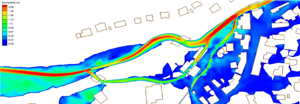
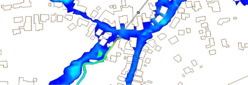
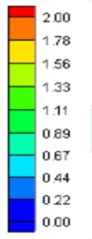
14 Spatial distribution of water depth for a given time slice (0,1-2m) 14

15 Example: flow vectors and depth 15

16 Endangered objects for HQ 30/100/300 HQ 30 HQ 100 HQ

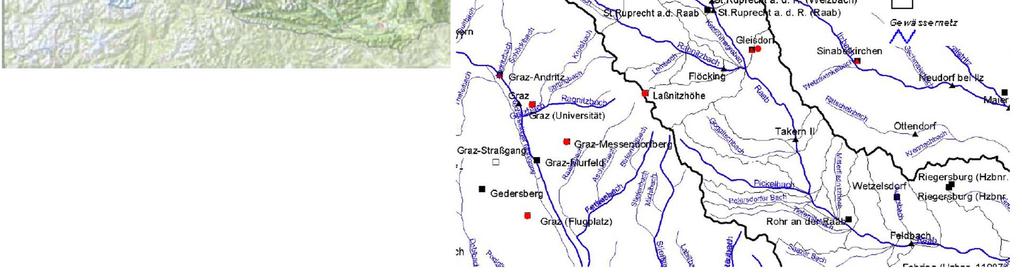
17 The location 17
18 Analysis of the younger history Hydrology Urban development 18
19 Analysis of the Flood Series 3 Annual maxima of the drain Q [ m /s] HQ Trend straight Flood series Feldbach
20 Analysis of the Flood Series HQ Trend straight Flood series Feldbach 3 Annual maxima of the drain Q [ m /s] Annual maxima of the drain Q [ m /s] HQ Trend straight Flood series Takern


21 Development in the Region Land survey 1787 GIS Styria, Flood protection project spillway Dykes FRB Flood release Dykes 21


22 Inundation area before 1999 Newly developed firms The goal was a protection level of HQ 100 Protection of 233 objects and 130 hectares Raab: Qmax = 200 m 3 /s Rabnitz: Qmax = 40 m 3 /s 22
23 Development within the last few years After implementation of the flood protection scheme an intensive development in the valley started Construction of some industrial plants Valley is crossed by several traffic lines: pedestrian, road, highway, and railway bridge 23
24 Scenarios What would be the situation without any flood protection? What is it like today? Log-jams at bridges HQ 300 flood HQ 1000 flood HQ 5000 (comparable to the flood in 2002) 24


25 Scenario 1 Flood area before implementation of flood control structures Raab: Q max = 200 m 3 /s Rabnitz: Q max = 40 m 3 /s probability: ~1/100 p.a. ZT Turk 1995 &
26 Scenario 2 Flood areas, Depths Raab: Q max = 200 m 3 /s Rabnitz: Q max = 40 m 3 /s probability: ~1/100 p.a. 26

27 Scenario 2 Flood areas, Depths Raab: Q max = 200 m 3 /s Rabnitz: Q max = 40 m 3 /s probability: ~1/100 p.a. 27
28 Scenario 3 Existing flood protection Depth of inundation log jam at the bridge 28


29 Scenario 4 inundation area and depth Raab: Q max = 245 m3/s Rabnitz: Q max = 56 m3/s flood probability:~ 1/300 29

30 Scenario 5 Inundation area and depth Raab: Q max = 310 m 3 /s Rabnitz: Q max = 82 m 3 /s flood probability: ~ 1/
31 Scenario 6 Inundation area and depth Raab: Q max = 400 m 3 /s Rabnitz: Q max = 97 m 3 /s flood probability: ~ 1/
32 Estimation of the possible damages object (structure, infrastructure...) contents (equipment...) Induced damages 32
33 Classification of Damages of Enterprises Property damages Building, heating systems, electric and electronic infrastructure. Vehicles Goods, products, stock levels Operating equipments, EDP... Loss due to service interruption: losses in sales volume and profit Location disadvantages Environmental consequences 33
34 Damage potentials Buildings in a GIS Attributs of the object qualities, classification, point layer Attributis of the flood depths of the scenarios, post-processing Representation of the scenarios All buildings: Reference values Additional elevation Industry, large trade Assignment damage functions to classes Individual estimation of damages via nterviews and local analysis Unity damages per object (Method point values) Damages per area unit (Method area values) Damage estimate about combination with flood depth of the scenarios Damage estimation Building Equipment Creation of value losses (duration, ) Environmental hazards Resultant effects Not monetary damages representation of damages 34


35 Consideration of hydraulics, topography and land use 35
36 Damage potentials Estimation based on reference values Method to BUWAL (1999) & BWG (2002) Converted & discounted Austria p., 2004 Damages in /building & damages in /m2 36
37 Damage potentials in industrial sectors: Damage types damages of property losses in production competitional disadvantages subsequent damages... Analysis at the site Information (presentation, informative material, distribution of a questionnaire) Contacting technical managers Common inspection Damage estimation. 37


38 Estimation of damage potentials Questionnaire 1st what can happen? 2nd description in monetary units 3rd mitigation 38
39 Damage potential in the industrial sector: Results from interviews 10 companies responded among them the 4 largest ones: Management and insurance companies are interested one company: internal mitigation measures some of them have an insurance: property and losses in production sensible topic (losses when the companies vulnerability would be identified from outside) difficult to get reliable response from the companies 39
40 Measures to reduce losses: Protection of objects (houses) Protection of companies (internally organised) Information, raising the awarness insurance Reduction of sensible points in the region Dikes should be redesigned (inundable) and consideration of runoff in the Hinterland 40
41 Information about possible scenarios & local measures (eg. Water proofing of objects) Training for a flood event: What to do? Removing cars, water tight closing of doors and windows, clearing the basement, closing sewers...) Improved warning and forecasting Insurance Precautionary Measures Privat & Companies 41

")
42 Water proving of objects Protection of Objects openings (doors, windows, sewers, garages, ventilation systems... Windows in the basement (BMLFUW, 2004) Typical flooding of objects (BMVBW, 2002) 42


43 Risk of dam failure and over topping Therefore, we have to consider also the failures of dikes!! 43
44 Integration of spillways into dykes According to the hydrological longitudinal profile several spillways have to be considered Where to locate them? Where large retention capacity is available After each tributary Where wetlands existed in the past Even in areas with dense population 44
45 General schem of the location of spillways Tributary Wirkungsbereiche spillways river kilometer 45

46 Runoff in the Hinterland Combination of DTM and hydraulic model 46
47 Spillways for Dikes If possible, simple spillways over a fixed dam crest Dam crest X* Flood water table Reduces the uncertainty in g(x*), inundation starts slowly, we know where and when and what happens in the Hinterland, and therefore lower damages will result 47


48 Increase of the Safety of Dikes Hochwasserschutz an der Gail Überströmstrecken bei Rückstaudeichen an der Donau (Wallsee, Altenwörth, Greifenstein.. 48
49 Summary and Conclusions Flood risk analysis Flood risk assessment methodology for the village of Gleisdorf Generation of scenarios A methodology for the assessment of damages (consideration of national and international documents) Information of the public is also required 49
50 Thank you for your attention!! 50
Appraising, prioritising and financing flood protection projects in Austria: Introduction of new Guidelines and Tools for Cost Benefit Analysis (CBA)
") Appraising, prioritising and financing flood protection projects in Austria: Introduction of new Guidelines and Tools for Cost Benefit Analysis (CBA) Heinz Stiefelmeyer 1, Peter Hanisch 2, Michael Kremser
Appraising, prioritising and financing flood protection projects in Austria: Introduction of new Guidelines and Tools for Cost Benefit Analysis (CBA) Heinz Stiefelmeyer 1, Peter Hanisch 2, Michael Kremser
Canada s exposure to flood risk. Who is affected, where are they located, and what is at stake
 Canada s exposure to flood risk Who is affected, where are they located, and what is at stake Why a flood model for Canada? Catastrophic losses Insurance industry Federal government Average industry CAT
Workshop of Working Group F on Floods (Vienna: )
") Workshop of Working Group F on Floods Vienna.04.06 Flood Risk Assessment in a Changing Environment H.P. Nachtnebel Dept. of Water-Atmosphere-Environment Univ. of Natural Resources and Applied Life Sciences
Workshop of Working Group F on Floods Vienna.04.06 Flood Risk Assessment in a Changing Environment H.P. Nachtnebel Dept. of Water-Atmosphere-Environment Univ. of Natural Resources and Applied Life Sciences
Planning and Flood Risk
 Planning and Flood Risk Patricia Calleary BE MEngSc MSc CEng MIEI After the Beast from the East Patricia Calleary Flood Risk and Planning Flooding in Ireland» Floods are a natural and inevitable part of
Micro-zonation-based Flood Risk Assessment in Urbanized Floodplain
 Proceedings of Second annual IIASA-DPRI forum on Integrated Disaster Risk Management June 31- August 4 Laxenburg, Austria Micro-zonation-based Flood Risk Assessment in Urbanized Floodplain Tomoharu HORI
FREQUENTLY ASKED QUESTION ABOUT FLOODPLAINS Michigan Department of Environmental Quality
 FREQUENTLY ASKED QUESTION ABOUT FLOODPLAINS Michigan Department of Environmental Quality WHAT IS A FLOOD? The National Flood Insurance Program defines a flood as a general and temporary condition of partial
BGC Project Memorandum
 Suite 500-1045 Howe Street, Vancouver, British Columbia, Canada. V6Z 2A9 Telephone (604) 684-5900 Fax (604) 684-5909 BGC Project Memorandum To: Attention: CANHUG Meeting Participants From: Kris Holm, BGC
A model for estimating flood damage in Italy: preliminary results
 Environmental Economics and Investment Assessment 65 A model for estimating flood damage in Italy: preliminary results F. Luino, M. Chiarle, G. Nigrelli, A. Agangi, M. Biddoccu, C. G. Cirio & W. Giulietto
Flood risk assessment for sustainable urban development : Case study of Marikina-Pasig-San Juan river basin, Manila
 International Conference in Urban and Regional Planning "Planning towards Sustainability and Resilience" 14 15 March, 2018 Manila, Philippines Flood risk assessment for sustainable urban development :
The AIR Inland Flood Model for Great Britian
 The AIR Inland Flood Model for Great Britian The year 212 was the UK s second wettest since recordkeeping began only 6.6 mm shy of the record set in 2. In 27, the UK experienced its wettest summer, which
Modelling (mountain) flood risk and managing its uncertainties
 flood risk and managing its uncertainties") DICA seminar Modelling (mountain) flood risk and managing its uncertainties 14 March 2016 Abstract 2 Modelling (mountain) flood risk and managing its uncertainties Hydraulic engineers fight against flood
DICA seminar Modelling (mountain) flood risk and managing its uncertainties 14 March 2016 Abstract 2 Modelling (mountain) flood risk and managing its uncertainties Hydraulic engineers fight against flood
Delineating hazardous flood conditions to people and property
 Delineating hazardous flood conditions to people and property G Smith 1, D McLuckie 2 1 UNSW Water Research Laboratory 2 NSW Office of Environment and Heritage, NSW Abstract Floods create hazardous conditions
Integrating Hazus into the Flood Risk Assessment
 Integrating Hazus into the Flood Risk Assessment GAFM Conference, March 22, 2016 Mapping Assessment Planning Agenda What is Hazus & Risk Assessment? Census Block vs. Site Specific Analysis User Defined
Guildford Borough Level 1 Strategic Flood Risk Assessment Summary Report. January 2016
 Guildford Borough Level 1 Strategic Flood Risk Assessment Summary Report January 2016 What is this document? This document provides a summary of Guildford Borough Strategic Flood Risk Assessment (SFRA,
Status of the implementation of FD 2007/60/EC in Austria and Styria
 OFFICE OF THE STYRIAN GOVERNMENT Department 14 Water Management, Resources and Sustainability Protective Water Management Unit Status of the implementation of FD 2007/60/EC in Austria and Styria Christoph
Mapping flood risk its role in improving flood resilience in England
 Mapping flood risk its role in improving flood resilience in England Catherine Wright Director of Digital and Skills Flood and Coastal Risk Management Environment Agency 6 October 2017 The Environment
AGRICULTURAL FLOOD LOSSES PREDICTION BASED ON DIGITAL ELEVATION MODEL
 AGRICULTURAL FLOOD LOSSES PREDICTION BASED ON DIGITAL ELEVATION MODEL Lei Zhu Information School, Central University of Finance and Economics, Beijing, China, 100081 Abstract: Key words: A new agricultural
Background to the PFRA European Overview UC10508
 Background to the PFRA European Overview UC10508 The individual Member State Reports reflect the situation as reported by the Member States to the European Commission in 2014 The situation in the MSs may
Flood Damage Assessment (Case study: Sirajganj District)
") Flood Damage Assessment (Case study: Sirajganj District) Photo Courtesy: Climate and Capitalism Photo Courtesy: Practical Action Blog A.K.M. Saiful Islam Professor Institute of Water and Flood Management
Flood Damage Assessment (Case study: Sirajganj District) Photo Courtesy: Climate and Capitalism Photo Courtesy: Practical Action Blog A.K.M. Saiful Islam Professor Institute of Water and Flood Management
Non Regulatory Risk MAP Products Flood Depth and Probability Grids
 Non Regulatory Risk MAP Products Flood Depth and Probability Grids Virginia Floodplain Management Association 2015 Floodplain Management Workshop October 29th, 2015 Nabil Ghalayini, P.E., PMP, D.WRE, CFM
FLOOD INUNDATION MAPPING SCIENCE. Gardner Bent, U.S. Geological Survey, New England Water Science Center
 FLOOD INUNDATION MAPPING SCIENCE Gardner Bent, U.S. Geological Survey, New England Water Science Center What is Flood Inundation Mapping? Flood Inundation Mapping (FIM) is a real-time, operational tool
NFIP Program Basics. KAMM Regional Training
 NFIP Program Basics KAMM Regional Training Floodplain 101 Homeowners insurance does not cover flood damage Approximately 25,000 flood insurance policies in KY According to BW12 analysis, approximately
Torrential flood risk management in Bavaria
 Bayerisches Landesamt für Umwelt Torrential flood risk management in Bavaria Dr.-Ing. Andreas Rimböck Unit: flood protection, torrent control Torrential flood risk management in Bavaria content History
National Institute of Building Sciences
 National Institute of Building Sciences Provider Number: G168 Improving the Flood Resistance of Buildings and Mitigation Techniques WE3B Peter Spanos, P.E., CFM, LEED AP (Gale Associates, Inc.) Stuart
National Disaster Mitigation Program NDMP Overview, Ontario Projects, and Final Call for Proposals
 National Disaster Mitigation Program NDMP Overview, Ontario Projects, and Final Call for Proposals March 6, 2018 NDMP Overview The NDMP is a 5-year federal program that set out $183 million for flood mitigation
Background to the PFRA European Overview UC10508
 Background to the PFRA European Overview UC10508 The individual Member State Reports reflect the situation as reported by the Member States to the European Commission in 2014 The situation in the MSs may
Adaptation Practices and Lessons Learned
 Adaptation Practices and Lessons Learned Increased Flooding Risk Due To Sea Level Rise in Hampton Roads: A Forum to Address Concerns, Best Practices and Plans for Adaptation Nov. 16, 2012 Virginia Modeling,
The new European Flood Management Directive and the municipal flood management system as one realization approach
 The new European Flood Management Directive and the municipal flood management system as one realization approach, Manuela Gretzschel University of Kaiserslautern, Germany Prof. Dr. Volker Lüderitz Magdeburg
Chapter 6 - Floodplains
 Chapter 6 - Floodplains 6.1 Overview The goal of floodplain management is to reduce the potential risks to both existing and future developments, and infrastructure, in the 100-year floodplain. Over the
FLOOD HAZARD AND RISK MANAGEMENT UTILIZING HYDRAULIC MODELING AND GIS TECHNOLOGIES IN URBAN ENVIRONMENT
 Proceedings of the 14 th International Conference on Environmental Science and Technology Rhodes, Greece, 3-5 September 2015 FLOOD HAZARD AND RISK MANAGEMENT UTILIZING HYDRAULIC MODELING AND GIS TECHNOLOGIES
Vulnerability and Risk Assessment for the PFRA in Ireland
 Vulnerability and Risk Assessment for the PFRA in Ireland Mark Adamson 1, Anthony Badcock 2 1 Office of Public Works, Ireland 2 Mott MacDonald Group, U.K. Abstract The Preliminary Flood Risk Assessment
Technical Memorandum 3.4 E Avenue NW Watershed Drainage Study. Appendix E Floodplain Impacts and Implications Memo
 Technical Memorandum 3.4 E Avenue NW Watershed Drainage Study Appendix E Floodplain Impacts and Implications Memo September 8, 2017 City of Cedar Rapids E Avenue Watershed Drainage Study Memo Date: Tuesday,
DEFINING BEST PRACTICE IN FLOODPLAIN MANAGEMENT
 DEFINING BEST PRACTICE IN FLOODPLAIN MANAGEMENT M Babister 1 M Retallick 1 1 WMAwater, Level 2,160 Clarence Street Sydney Abstract With the upcoming release of the national best practice manual, Managing
The 2004 Gilbert F. White National Flood Policy Forum September 21-22, 2004 FLOOD STANDARDS IN FOREIGN COUNTRIES
 The 2004 Gilbert F. White National Flood Policy Forum September 21-22, 2004 FLOOD STANDARDS IN FOREIGN COUNTRIES Firas Makarem, Dewberry, International Committee Chair, Association of State Floodplain
Czech Republic 2007/60/EC
 Czech Republic 2007/60/EC Methodology & Results of the Flood Risk Mapping Budapest, 16.11.2009 V4 on Flood Protection Ing. Vaclav Jirasek Ing. Petr Brezina Present situation overview Legislation status
CRISP COUNTY, GEORGIA AND INCORPORATED AREAS
 CRISP COUNTY, GEORGIA AND INCORPORATED AREAS Community Name Community Number ARABI, CITY OF 130514 CORDELE, CITY OF 130214 CRISP COUNTY (UNINCORPORATED AREAS) 130504 Crisp County EFFECTIVE: SEPTEMBER 25,
Door County Floodplain Program Informational Meeting
 Door County Floodplain Program Informational Meeting Door County Land Use Services Department Wisconsin Department of Natural Resources January 15, 2018 Floodplain = Land affected by flood event with a
Development of an Integrated Simulation Model for Flood Risk Evaluation and Damage Assessment
 Development of an Integrated Simulation Model for Flood Risk Evaluation and Damage Assessment presented by Professor Emeritus Charng Ning CHEN School of Civil & Environmental Engineering (CEE), and Principal
Risk Assessment for Floods Due to Precipitation Exceeding Drainage Capacity
 Risk Assessment for Floods Due to Precipitation Exceeding Drainage Capacity November 2006 Umut Karamahmut Faculty of Civil Engineering and Geosciences i i. Abstract Studies on flood risk modeling were
DANUBE FLOODRISK PROJECT
 FLOOD CBA MEETING, Oxford, 20-21 May, 2013 Strategic Project DANUBE FLOODRISK PROJECT Cooperation for Hazard and Risk Maps Atlas production along the Danube and its continuation in RO by FLOOD CBA Project
Use of FEMA Non regulatory Flood Risk Products in Planning
 Use of FEMA Non regulatory Flood Risk Products in Planning Georgia Association of Floodplain Managers Annual Conference March 24, 2016 What are the Non regulatory Flood Risk products? Go beyond the basic
SWIF TO THE RESCUE. Patty Robinson Ike Pace, PE WATER NATURAL RESOURCES ENVIRONMENT INFRASTRUCTURE ENERGY
 SWIF TO THE RESCUE Patty Robinson Ike Pace, PE WATER NATURAL RESOURCES ENVIRONMENT INFRASTRUCTURE ENERGY AGENDA USACE Programs PL 84 99 (Rehabilitation & Inspection Program, RIP) Levee Safety Program (Routine,
Flood Risk Management in the EU and the Floods Directive's 1 st Cycle of Implementation ( )
") COMMON IMPLEMENTATION STRATEGY FOR THE WATER FRAMEWORK DIRECTIVE AND THE FLOODS DIRECTIVE Flood Risk Management in the EU and the Floods Directive's 1 st Cycle of Implementation (2009-15) A questionnaire
COMMON IMPLEMENTATION STRATEGY FOR THE WATER FRAMEWORK DIRECTIVE AND THE FLOODS DIRECTIVE Flood Risk Management in the EU and the Floods Directive's 1 st Cycle of Implementation (2009-15) A questionnaire
Handbook on good practices for flood mapping in Europe
 EXCIMAP European exchange circle on flood mapping floodmapping in Europe European exchange circle on flood mapping Prepaired by EXCIMAP (a European exchange circle on flood mapping) Endorsed by Water Directors,
GUIDANCE ON NATIONAL FLOOD RISK ASSESSMENTS
 GUIDANCE ON NATIONAL FLOOD RISK ASSESSMENTS bcd Document Information Project National flood risk assessment Report title Cover photograph Flood maps and photographs of flooding in Mozambique Client Department
REQUEST FOR PROPOSALS. Planning in Water s Way: Flood Resilient Economic Development Strategy for the I-86 Innovation Corridor
 REQUEST FOR PROPOSALS Planning in Water s Way: Flood Resilient Economic Development Strategy for the I-86 Innovation Corridor Southern Tier Central Regional Planning and Development Board (STC) is seeking
A Flood Mitigation Plan for the Non-Tidal N.J. Section of the Delaware River Basin. Warren County Planning Workshop (2 nd Meeting) March 7, 2007
 March 7, 2007") A Flood Mitigation Plan for the Non-Tidal N.J. Section of the Delaware River Basin Warren County Planning Workshop (2 nd Meeting) March 7, 2007 Study Area Participation: Hunterdon: 16 Eligible Municipalities
A Flood Mitigation Plan for the Non-Tidal N.J. Section of the Delaware River Basin Warren County Planning Workshop (2 nd Meeting) March 7, 2007 Study Area Participation: Hunterdon: 16 Eligible Municipalities
Kentucky Risk MAP It s not Map Mod II
 Kentucky Risk MAP It s not Map Mod II Risk Mapping Assessment and Planning Carey Johnson Kentucky Division of Water carey.johnson@ky.gov What is Risk MAP? Risk Mapping, Assessment, and Planning (Risk MAP)
Improved tools for river flood preparedness under changing risk - Poland
 7th Study Conference on BALTEX, Borgholm, Sweden, 10-14 June 2013 Improved tools for river flood preparedness under changing risk - Poland Zbigniew W. Kundzewicz Institute of Agricultural and Forest Environment,
Corps Water Management System (CWMS)
") Corps Water Management System (CWMS) Real-Time Decision Support Modeling & Mapping Inter-Agency Flood Risk Characterization Workshop Christopher N. Dunn, P.E., D. WRE, Director Hydrologic Engineering Center
Corps Water Management System (CWMS) Real-Time Decision Support Modeling & Mapping Inter-Agency Flood Risk Characterization Workshop Christopher N. Dunn, P.E., D. WRE, Director Hydrologic Engineering Center
Development Fee Program: Comparative risk analysis
 Development Fee Program: Comparative risk analysis January 2008 Sacramento Area Flood Control Agency David Ford Consulting Engineers, Inc. 2015 J Street, Suite 200 Sacramento, CA 95811 Ph. 916.447.8779
AIR Inland Flood Model for Central Europe
 AIR Inland Flood Model for Central Europe In August 2002, an epic flood on the Elbe and Vltava rivers caused insured losses of EUR 1.8 billion in Germany and EUR 1.6 billion in Austria and Czech Republic.
New Tools for Mitigation & Outreach. Louie Greenwell Stantec
 New Tools for Mitigation & Outreach Louie Greenwell Stantec Our Discussion Today Background What is Risk MAP? FEMA Products Overview of RiskMAP Data Sets Changes Since Last FIRM Depth and Analysis Grids
Strategic Flood Risk Assessment for SDCC Development Plan
 Strategic Flood Risk Assessment for SDCC Development Plan Detailed Report on Flood Risk in the Baldonnell Area 8 th May 2015 rpsgroup.com/ireland Strategic Flood Risk Assessment for SDCC Development Plan
7. Understand effect of multiple annual exposures e.g., 30-yr period and multiple independent locations yr event over 30 years 3%
 I. FLOOD HAZARD A. Definition 1. Hazard: probability of water height 2. At a Specific XY floodplain location; 3. Z can be expressed as elevation (NAVD88); gauge height; height above ground (depth). 4.
EUROPEAN DIRECTIVE FLOODS 2007/60/EC AND RIVER BASIN PLANNING
 EUROPEAN DIRECTIVE FLOODS 2007/60/EC AND RIVER BASIN PLANNING Fare clic per modificare lo stile del sottotitolo dello schema Ing. Giorgio Cesari General Secretary of Tevere river basin Authority TEVERE
Strategic Flood Risk Assessment
 Strategic Flood Risk Assessment Ireland West Airport Knock Local Area Plan 2012 2018 Prepared by Forward Planning Section Mayo County Council 0 1 Table of Contents Section 1: Overview of the Guidelines...
The approach to managing natural hazards in this Plan is to: set out a clear regional framework for natural hazard management
 10 Natural Hazards 10.1 Scope and Background This chapter establishes an overall framework for natural hazard management under the Resource Management Act 1991 (RMA). It also sets out the division of responsibilities
Strategic Flood Risk Assessment
 Strategic Flood Risk Assessment Draft Claremorris Local Area Plan 2012 2018 Prepared by Forward Planning Section Mayo County Council 1 Table of Contents Section 1: Overview of the Guidelines... 4 1.1 Introduction...
FLOOD RISK SCENARIO CALCULATIONS AS A DECISION SUPPORT AND EVALUATION TOOL IN WATER MANAGEMENT PLANS
 FLOOD RISK SCENARIO CALCULATIONS AS A DECISION SUPPORT AND EVALUATION TOOL IN WATER MANAGEMENT PLANS Wouter Vanneuville 1, Pieter Deckers 2, Katrien Van Eerdenbrugh 1, Frank Mostaert 1 1 Authorities of
The AIR Inland Flood Model for the United States
 The AIR Inland Flood Model for the United States In Spring 2011, heavy rainfall and snowmelt produced massive flooding along the Mississippi River, inundating huge swaths of land across seven states. As
Floods Directive (2007/60/EC) : Reporting sheets Endorsed by Water Directors : - 30 November December 2010
 : Reporting sheets Endorsed by Water Directors : - 30 November December 2010") Floods Directive (2007/60/EC) : Reporting sheets Endorsed by Water Directors : - 30 November 2009-3 December 2010 Version 2 - February 2011 1(25) Title: Floods Directive (2007/60/EC) : Reporting sheets,
Floods Directive (2007/60/EC) : Reporting sheets Endorsed by Water Directors : - 30 November 2009-3 December 2010 Version 2 - February 2011 1(25) Title: Floods Directive (2007/60/EC) : Reporting sheets,
SPILLWAY ADEQUACY ANALYSIS ROUGH RIVER LAKE LOUISVILLE DISTRICT
 SPILLWAY ADEQUACY ANALYSIS OF ROUGH RIVER LAKE LOUISVILLE DISTRICT RICHARD PRUITT (502) 315-6380 Louisville District COE richard.l.pruitt@lrl02.usace.army.mil Spillway ROUGH RIVER LAKE PERTINENT DATA Construction
Implementation of Water Framework and Flood Directive in Finland. Markku Maunula Finnish Environment Institute
 Implementation of Water Framework and Flood Directive in Finland Markku Maunula Finnish Environment Institute Finland is rich in freshwater About 11 % of surface is covered by water The number of lakes
Understanding Risk Balkans Conference, Belgrade, Serbia, September 17-19, 2018
 Understanding Risk Balkans Conference, Belgrade, Serbia, September 17-19, 2018 Implementa)on in Poland of the European Union Flood Direc)ve on the Assessment and Management of Floods pros and cons Janusz
Danube Floodrisk Project
 Danube Floodrisk Project Mary-Jeanne Adler 1, Olimpia Negru 1, Simona Pătruţ 1 1 Ministry of Environment and Forests, Bucharest, Romania Abstract The Danube Floodrisk Project is an important contribution
Frequently Asked Questions Oxbow / Hickson / Bakke Ring Levee Option
 Frequently Asked Questions Oxbow / Hickson / Bakke Ring Levee Option October 16, 2012 Q1. Why has the position on a ring-levee changed? The feasibility study recommended buy-outs for areas with staging
Overview of Capabilities and Current Limitations
 Overview of Capabilities and Current Limitations Overview of the National Flood Risk Characterization Tool (NFRCT) Map based viewer of relative flood risk around the U.S., with supporting reports for more
THE PEOPLE OF THE STATE OF MICHIGAN ENACT:
 DRAFT A bill to authorize local units of government to create storm water utilities; to permit the establishment and collection of storm water utility fees; to provide for the allocation of the costs of
Damage assessment in the stress field of scale, comparability and transferability
 Damage assessment in the stress field of scale, comparability and transferability André Assmann 1,a and Stefan Jäger 1 1 geomer GmbH, Im Breitspiel 11B, 69126 Heidelberg, Germany Abstract. Damage assessment
CHAPTER THREE Natural Hazard Mitigation Strategy
 CHAPTER THREE Natural Hazard Mitigation Strategy Chapter 3 Section All Sections Updates to Section Revised Natural Hazards Introduction and all Sections to change Natural Hazards Subcommittee to Committee.
FOR TO THE GAELTACHT LOCAL AREA PLAN MARCH 2013
 APPENDIX II TO THE SEA ENVIRONMENTAL REPORT STAGE 2 STRATEGIC FLOOD RISK ASSESSMENT FOR PROPOSED AMENDMENT TO THE GAELTACHT LOCAL AREA PLAN 2008-2014 for: Galway County Council County Buildings Prospect
Chapter 5 Floodplain Management
 Chapter 5 Floodplain Management Contents 1.0 Introduction... 1 2.0 Floodplain Management and Regulation... 1 2.1 City Code... 1 2.2 Floodplain Management... 1 2.3 Level of Flood Protection... 2 2.3.1 Standard
Downstream Consequence of Failure Classification Interpretation Guideline
 Downstream Consequence of Failure Classification Interpretation Guideline Dam Safety Program Ministry of Forests, Lands and Natural Resource Operations Revised March 2017 Table of Contents Introduction...
BACKGROUND When looking at hazard and loss data for future climate projections, hardly any solid information is available.
 BACKGROUND Flooding in Europe is a peak peril that has the potential to cause losses of over 14 billion in a single event. Most major towns and cities are situated next to large rivers with large amounts
Regulations Regarding Preliminary Flood Risk Assessment, Flood Maps and Flood Risk Management Plan
 Text consolidated by Valsts valodas centrs (State Language Centre) with amending regulations of: 20 March 2012 [shall come into force from 23 March 2012]. If a whole or part of a paragraph has been amended,
WG F 20 Workshop - Berlin
 WG F 20 Workshop - Berlin THE PLUVIAL PFRA IN IRELAND Mark Adamson Office of Public Works 4 th October, 2016 OVERALL APPROACH TO PFRA OVERALL APPROACH Risk Assessment Three-String Approach Historic FRA
Floods Directive (2007/60/EC) : Reporting sheets Version November 2009
 : Reporting sheets Version November 2009") Floods Directive (2007/60/EC) : Reporting sheets Version November 2009 Endorsed by Water Directors 30 November 2009 1 of 19 Title:, version November 2009 Version no.: Final Date: 30 November 2009 History
Floods Directive (2007/60/EC) : Reporting sheets Version November 2009 Endorsed by Water Directors 30 November 2009 1 of 19 Title:, version November 2009 Version no.: Final Date: 30 November 2009 History
Method for he Estimation of Loss of Life Caused by Floods in the Netherlands
 GIS & RS in Hydrology, Water Resources and Environment, Volume 1, Chen et al. (eds) Method for he Estimation of Loss of Life Caused by Floods in the Netherlands S.N. Jonkman Road and Hydraulic Engineering
RiskTopics. Guide to flood emergency response plans September 2017
 RiskTopics Guide to flood emergency response plans September 2017 While floods are a leading cause of property loss, a business owner can take actions to mitigate and even help prevent damage and costly
SOUTH CENTRAL REGION MULTI-JURISDICTION HAZARD MITIGATION PLAN. Advisory Committee Meeting September 12, 2012
 SOUTH CENTRAL REGION MULTI-JURISDICTION HAZARD MITIGATION PLAN Advisory Committee Meeting September 12, 2012 AGENDA FOR TODAY Purpose of Meeting Engage All Advisory Committee Members Distribute Project
Vocabulary of Flood Risk Management Terms
 USACE INSTITUTE FOR WATER RESOURCES Vocabulary of Flood Risk Management Terms Appendix A Leonard Shabman, Paul Scodari, Douglas Woolley, and Carolyn Kousky May 2014 2014-R-02 This is an appendix to: L.
Mill Creek Floodplain Proposed Bylaw Frequently Asked Questions
 Mill Creek Floodplain Proposed Bylaw Frequently Asked Questions Q: What is a Floodplain Bylaw? A: A Floodplain Bylaw is a flood hazard management tool to ensure future land use will be planned and buildings
Flood Hazards and Flood Risk, the Impact of a Changing Climate
 Flood Hazards and Flood Risk, the Impact of a Changing Climate Sally A. McConkey, P.E. CFM, D. WRE. Illinois State Water Survey June 14, 2017 Topics ISWS Coordinated Hazard Assessment and Mapping Program
Volusia County Floodplain Management Plan 2012
 Volusia County Floodplain Management Plan 2012 Introduction The National Flood Insurance Program (NFIP) provides federally supported flood insurance in communities that regulate development in floodplains.
ANNEX B: TOWN OF BLUE RIVER
 ANNEX B: TOWN OF BLUE RIVER B.1 Community Profile Figure B.1 shows a map of the Town of Blue River and its location within Summit County. Figure B.1. Map of Blue River Summit County (Blue River) Annex
Flood Hazard Maps: An Update
 Flood Hazard Maps: An Update Ir BIBI ZARINA BINTI CHE OMAR JABATAN PENGAIRAN DAN SALIRAN MALAYSIA 9 Jun 2014 Introduction INTRODUCTION Flooding is a natural phenomenon and has been occurring for millions
Two cases: Naga City Hangberg, Cape Town
 PMapping and PGIS for Participatory Hazard-Risk Management (CRA) M.K. McCall, ITC, Enschede Use of GIS and RS in Disaster Risk Management APDC ITC AIT Bangkok, May 2008 Two cases: Naga City Hangberg, Cape
Flood Investigation Report
 Flood Investigation Report Bar Hill 1.1 Background As the Lead Local Flood Authority (LLFA) for Cambridgeshire, it is Cambridgeshire County Council s duty to investigate flood incidents as detailed within
Chapter Flood Consequences
 Chapter 2.16. Flood Consequences 438 16. Flood Consequences 16.1. Introduction and Scope of Topic 16.1.1. This chapter identifies and describes the existing flood risk features along the route of the Scheme
TOWN OF KENT, CT PLANNING AND ZONING COMMISSION
 TOWN OF KENT, CT PLANNING AND ZONING COMMISSION FLOOD PLAIN MANAGEMENT REGULATIONS Whereas, Congress has determined that a National Flood Insurance Program would alleviate personal hardships and economic
IMPORTANCE OF DISTRIBUTED HYDROLOGICAL MODEL FOR PRESENT AND FUTURE FLOOD RISK MANAGEMENT IN BANGLADESH
 IMPORTANCE OF DISTRIBUTED HYDROLOGICAL MODEL FOR PRESENT AND FUTURE FLOOD RISK MANAGEMENT IN BANGLADESH Md. Khairul Isalm Supervisors: Kuniyoshi Takeuchi MEE13624 Dr. Youngjoo Kwak ***, Dr. Maksym Gusyev
Flood impact Urban area. Include climate change scenarios; Flood extent & Rijnmond-Drechtsteden region; depth. Apply a high level of detail;
 William Veerbeek FLOOD RESILIENCE GROUP WE Department Unesco-IHE Westvest 7 P.O. Box 315 261DA Delft Netherlands T: +31()15 2151 821 M: +31()6 427 88 359 w.veerbeek@floodresiliencegroup.org www.floodresiliencegroup.org
15-17 Unwins Bridge Road St Peters NSW September 2013
 Marrickville Council j:\jobs\112010\propertytagging\letter020813.docx 15-17 Unwins Bridge Road St Peters NSW 2044 18 September 2013 Review of Marrickville Council s Property Flood Tagging INTRODUCTION
National Elevation Data for National Flood Insurance Policy; NFIP & 3DEP Efforts John JB Byrd of John M. Palatiello & Associates, Inc.
 National Elevation Data for National Flood Insurance Policy; NFIP & 3DEP Efforts John JB Byrd of John M. Palatiello & Associates, Inc. Government Affairs Manager (MAPPS) Lobbyist (NSPS) November 3, 2015
BRITISH COLUMBIA DAM SAFETY REGULATION 44/2000
 PDF Version [Printer friendly ideal for printing entire document] BRITISH COLUMBIA DAM SAFETY REGULATION 44/2000 Published by Important: Quickscribe offers a convenient and economical updating service
ATTACHMENT 1. Amendments to Chapter 18.20, Definitions Area of shallow flooding Area of special flood hazard
 Amendments to Chapter 18.20, Definitions 18.20.206 Area of shallow flooding Area of shallow flooding means a designated AO, or AH, AR/AO, AR/AH, or VO Zone on the a community's flood insurance rate map
Article 23-6 FLOODPLAIN DISTRICT
 AMENDING THE CODE OF THE CITY OF PITTSFIELD CHAPTER 23, ZONING ORDINANCE SECTION I That the Code of the City of Pittsfield, Chapter 23, Article 23-6 Floodplain District, shall be replaced with the following:
Presented by: Connie Perkins, PE, CFM April 20, 2016
 Presented by: Connie Perkins, PE, CFM April 20, 2016 City of Sacramento s Flood History Need for a Comprehensive Flood Management Plan (CFMP) Overview of Sacramento s CFMP 2016 Next Steps Sacramento
Coastal Flood Hazard and Risk Maps in Denmark. Thorsten Piontkowitz & Laura Storm Henriksen, Danish Coastal Authority
 Coastal Flood Hazard and Risk Maps in Denmark Thorsten Piontkowitz & Laura Storm Henriksen, Danish Coastal Authority Contents Introduction Denmark and the coastal zone Identified flood prone areas Flood