Flood Damage Assessment (Case study: Sirajganj District)
|
|
|
- Julie Lucas
- 6 years ago
- Views:
Transcription
 Photo Courtesy: Climate")


1 Flood Damage Assessment (Case study: Sirajganj District) Photo Courtesy: Climate and Capitalism Photo Courtesy: Practical Action Blog A.K.M. Saiful Islam Professor Institute of Water and Flood Management Bangladesh University of Engineering and Technology (BUET)
2 Flood Hazard Flood hazard is defined as the exceedance probability of potentially damaging flood situations in a given area and within a specified period of time (Mertz et al., 2007; ITC, 2004).
3 Factors Influencing Flood Damage Assessment The area of inundation in combination with land use data, reveals which elements at risk would be affected in case of a certain flood event. Inundation depth the water depth has been identified by different studies as the flood characteristics which has the biggest influence on flood damage.
4 Factors Influencing Flood Damage Assessment The duration of inundation is often of importance since the degree of damage is often related to it. This applies to structural safety, the effect of interruption in communications, industrial activity and public services, and agriculture. In many cases, failure of river embankments is also influenced by the duration of the flood water level.
5 Factors Influencing Flood Damage Assessment Another important criterion for flood intensity is the flow velocity. It becomes important particularly in mountainous areas or flash flood areas where flow velocities are high, which can lead to dramatic damages to buildings, infrastructures, standing crops.
6 Factors Influencing Flood Damage Assessment The rate of rise of flood may also have an influence on flood damages. A high rise rate will reduce the time for warning and evacuation and therefore could increase damages or movable assets. It may therefore influence planning permission for floodplain occupation and its zoning. The consideration of rate of water rise necessitates, similar to flow velocity, a larger effort.
7 Factors Influencing Flood Damage Assessment The time of occurrence of flooding is usually important when calculating damages to agriculture. Damages would be quite high if flooding occurs just before the harvest of the respective crops, while they could be relatively low in the case of flooding in early stages such that damages can be recovered by replantation of crops.
8 Flood Vulnerability ISDR (2004), which defines vulnerability as the set of conditions and processes resulting from physical, social, economic and environmental factors, which increase the susceptibility of a community to the impact of hazards. ITC (2004) defined vulnerability as the degree of loss resulting from the occurrence of a phenomenon.
9 Flood Vulnerability Jones and Boer (2003) defined vulnerability as the amount of potential damage caused to a system by a particular-related event or hazard. Mertz et al. (2007) conceptualized flood vulnerability as being composed of two elements, exposure (or damage potential) and loss (susceptibility).
10 Exposure and Susceptibility Exposure analysis answers the question Who or what will be affected by floods? Exposure can be quantified by the number or the value of elements which are at risk. In a flood prone area, the exposure may be quantified by the total assets (buildings, transportation facilities, agriculture) within the design 100-year inundation area. The analysis of susceptibility will then answer the question How will the affected elements will be damaged? Susceptibility is usually described by relative damage functions (e.g. depth-damage curves).
11 Flood Risks Mertz et al. (2007) defines risk as the probability that floods of a given intensity and a given loss will occur in a certain area within a specified time period, implying that risk results from the interaction of hazard and vulnerability.
12 Other concepts of Risk

 Development of Flood Hazard and")

13 Case Study Damage Assessment for flooding in Sirajganj District References Mozammel et al. (2011) Development of Flood Hazard and Risk Maps with Effect of Climate Change Scenario ( climate/report/component_1.pdf)
14 Sirajganj Sadar Upazila Sirajganj Sadar Upazila with an area of sq km is bounded by Kazipur Upazila on the north, Kamarkhanda and Belkuchi Upazilas on the south, Kalihati and Bhuapur Upazilas on the east, Kamarkhanda, Raiganj and Dhunat Upazilas on the west.
15 Sirajganj Sadar Upazila The area falls in a major Agro Ecological Zones (AEZ), which is the Active Brahmaputra- Jamuna Floodplain (AEZ-8). Siraganj is located in north-western zone of Bangladesh which has less rainfall. The annual rainfall is 1610 mm.
16 Sirajganj Sadar Upazila In the north, June has a mean rainfall exceeding 500 mm whereas in the south no month has a mean rainfall exceeding 300 mm. However, the main river, the Brahmaputra brings the largest transboundary inflow from upstream catchment area.

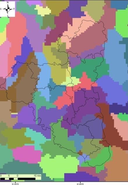
17 Map of the Study area
18 Sirajganj Sadar Upazila Major important rivers in and around Sirajganj are Brahmaputra-Jamuna, Bangali, Jamuneswari, Karatoa, and Hurasagar. Sirajganj is considered as the most disaster prone area to river flood and bank erosion. Widespread flooding, shifting river channels, constantly eroding cultivated land and settlement and displacement of people are the main problems in this area.
19 Sirajganj Sadar Upazila Total population of the Sirajganj Sadar Upazila is , with male 51.54%, female 48.46%; Muslim 95.16%, Hindu 4.80% and others 0.04% (Banglapedia, 2006). About 25.2% of people involved in agricultural activities. Other occupations include agricultural labourer 15.76%, wage labourer 4.37%, commerce 16.09%, service 12.55%, weaving 4.10%, transport 3.53%, industrial labourer 4.12%, others 14.31%.
20 Sirajganj Sadar Upazila Land use status of Sirajganj Sadar Upazila shows that the total cultivable land is hectares and fallow land is hectares. About 21.44% of the land is single cropped, 47.54% double cropped and 31.02% triple cropped. Main crops include paddy, jute, wheat, mustard seed, sugarcane, onion, garlic, potato, sweet potato, chilli and ground nut.
21 Water level and Discharge gage stations of BWDB River Station Station Name Bangali SW11.5 Nalkasengati Brahmaputra-Jamuna SW49 Sirajganj Brahmaputra-Jamuna SW49A Kazipur Deonai/Charalkata/ Jamuneswari/Karatoa Karatoa/Atrai/Gur Gumani/Hurasagar SW66 SW151 Ullapara Railway Crossing Baghabari Nangoora SW313 Nangoora Old Bangali SW324 Dhunot
 Sirajganj (b)")
22 River network, including locations of water level and discharge gage stations (a) Sirajganj (b) Hobi
23 Watershed Delineation using GIS Tools Watershed


24 Landuse and hydrographic map of Sirajganj Sadar Landuse map of Sirajganj sadar Location of water level stations
25 Flood Frequency Analysis The regression test for linear trend has been carried out for the annual water level series from 1981 to 2002 at Khanpur SW 11 station of Bangali river, Sirajganj SW 49 station of Brahmaputra - Jamuna river and Ulapara Rail crossing SW 66 of Deonai river. The graphical trend line of peak water level for all three stations have been drawn in Figure.
26 Frequency analysis on Brahmaputra River Then trend free hydrologic data have been used to determine designed flood levels for several return periods (2.33yr, 05yr, 10yr, 20yr, 50yr and 100yr floods) through flood frequency analysis. For selecting best fitted distribution, goodness-of-fit test has been conducted. In the goodness-of-fit test, Probability Plot Correlation Coefficient (PPCC) had been applied.
27 Goodness-of-fit test for selecting most appropriate distribution, SW11 PDF Return Period PPCC Rank LN LN P LP EV
28 Flood Frequency Analysis

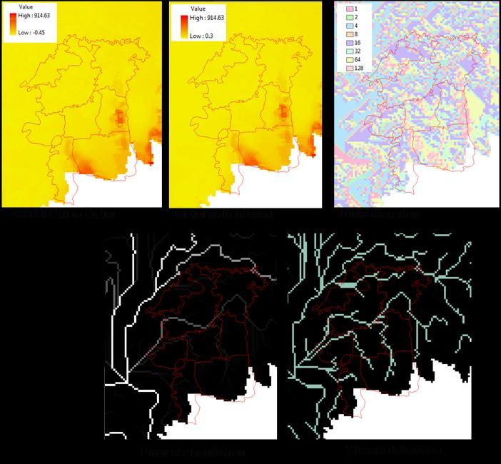
29 Inundation map at different return period


30 Inundation maps at different return periods
31 Loss/Vulnerability Function A stage-damage curve normally relates to a specific class of buildings or crops and presents information on the relationship of flood damage to depth of flooding (or stage). For example, crop stage-damage curve has been developed through several field survey are conducted to gathering of crop damage data from actual flood event such as 1988, 1998, 2004 and 2007 the major flood in Sirajganj with respect to flood depth in agriculture land.
32 Settlement Vulnerability Valuation surveys are conducted for the settlement vulnerability assessment. Settlement has been classified in four type such as (BB) brick floor-brick Wall, (BC) Brick floor-ci Sheet wall, (MC) Mud floor CI Sheet wall, (MM) Mud floor Mud(wall). For the selected properties the surveyor quantifies the damage of all items due to flood and their current value based on type, quality and degree of wear. The survey included information on the height above the floor of each item or the heights can be taken as standard from house to house. The information for all samples of each element class is then averaged and stage-damage curves constructed. In the crop stage-damage curve and settlement stagedamage curve vulnerability has been scale 0 to 1. Zero (0) indicates there is no damage, 0.5 vulnerability indicates 50 percent damage and 1.0 vulnerability indicate 100 percent damage of crops and settlements
33 Normalized Depth-Damage Curve agriculture settlement
34 Crop Vulnerability Classification Return Period Classification Flood Depth Vulnerability Range(m) 100yr, 20yr & 2.33yr Very Low vulnerable Low vulnerable Moderate vulnerable High Vulnerable Very high vulnerable
35 Settlement Vulnerability Classification Return Period Classification Flood Depth Vulnerability Range(m) 100yr, 20yr & 2.33yr Very Low vulnerable Low vulnerable Moderate vulnerable High Vulnerable Very high vulnerable
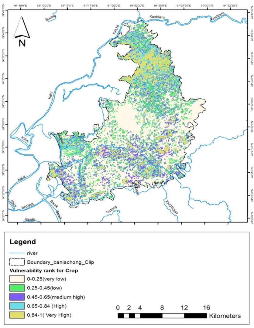
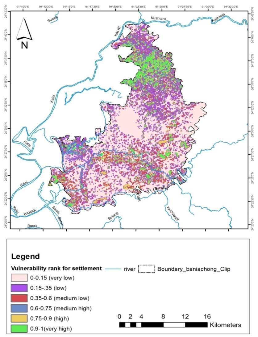
36 Vulnerability Maps
37 Thank you Questions?
The AIR Inland Flood Model for Great Britian
 The AIR Inland Flood Model for Great Britian The year 212 was the UK s second wettest since recordkeeping began only 6.6 mm shy of the record set in 2. In 27, the UK experienced its wettest summer, which
BGC Project Memorandum
 Suite 500-1045 Howe Street, Vancouver, British Columbia, Canada. V6Z 2A9 Telephone (604) 684-5900 Fax (604) 684-5909 BGC Project Memorandum To: Attention: CANHUG Meeting Participants From: Kris Holm, BGC
Flood risk assessment for sustainable urban development : Case study of Marikina-Pasig-San Juan river basin, Manila
 International Conference in Urban and Regional Planning "Planning towards Sustainability and Resilience" 14 15 March, 2018 Manila, Philippines Flood risk assessment for sustainable urban development :
Delineating hazardous flood conditions to people and property
 Delineating hazardous flood conditions to people and property G Smith 1, D McLuckie 2 1 UNSW Water Research Laboratory 2 NSW Office of Environment and Heritage, NSW Abstract Floods create hazardous conditions
FLOOD HAZARD AND RISK MANAGEMENT UTILIZING HYDRAULIC MODELING AND GIS TECHNOLOGIES IN URBAN ENVIRONMENT
 Proceedings of the 14 th International Conference on Environmental Science and Technology Rhodes, Greece, 3-5 September 2015 FLOOD HAZARD AND RISK MANAGEMENT UTILIZING HYDRAULIC MODELING AND GIS TECHNOLOGIES
Climate Risk Insurance Models from India
 Climate Risk Insurance Models from India Regional Dialogue on Climate Resilient Growth & Development Dhyanesh Bhatt 21 st Feb 2018 Agenda Crop insurance in India Guwahati city & Risk financing A case study
Canada s exposure to flood risk. Who is affected, where are they located, and what is at stake
 Canada s exposure to flood risk Who is affected, where are they located, and what is at stake Why a flood model for Canada? Catastrophic losses Insurance industry Federal government Average industry CAT
Implementation of Water Framework and Flood Directive in Finland. Markku Maunula Finnish Environment Institute
 Implementation of Water Framework and Flood Directive in Finland Markku Maunula Finnish Environment Institute Finland is rich in freshwater About 11 % of surface is covered by water The number of lakes
G318 Local Mitigation Planning Workshop. Module 2: Risk Assessment. Visual 2.0
 G318 Local Mitigation Planning Workshop Module 2: Risk Assessment Visual 2.0 Unit 1 Risk Assessment Visual 2.1 Risk Assessment Process that collects information and assigns values to risks to: Identify
DEFINING BEST PRACTICE IN FLOODPLAIN MANAGEMENT
 DEFINING BEST PRACTICE IN FLOODPLAIN MANAGEMENT M Babister 1 M Retallick 1 1 WMAwater, Level 2,160 Clarence Street Sydney Abstract With the upcoming release of the national best practice manual, Managing
Flood risk analysis and assessment: Case Study Gleisdorf
 Flood risk analysis and assessment: Case Study Gleisdorf H.P. Nachtnebel River room agenda Alpenraum 1 Integrated Flood Risk Managament Risk Assessment Increase of Resistance Reduction of Losses Prepardness
Planning and Flood Risk
 Planning and Flood Risk Patricia Calleary BE MEngSc MSc CEng MIEI After the Beast from the East Patricia Calleary Flood Risk and Planning Flooding in Ireland» Floods are a natural and inevitable part of
The 2004 Gilbert F. White National Flood Policy Forum September 21-22, 2004 FLOOD STANDARDS IN FOREIGN COUNTRIES
 The 2004 Gilbert F. White National Flood Policy Forum September 21-22, 2004 FLOOD STANDARDS IN FOREIGN COUNTRIES Firas Makarem, Dewberry, International Committee Chair, Association of State Floodplain
C o p e r n i c u s E m e r g e n c y M a n a g e m e n t S e r v i c e f o r R i s k p l a n n i n g a n d R e c o v e r y
 C o p e r n i c u s E m e r g e n c y M a n a g e m e n t S e r v i c e f o r R i s k p l a n n i n g a n d R e c o v e r y Copernicus Service Copernicus EU Copernicus EU Copernicus EU www.copernicus.eu
Upper Joachim Creek Public Survey on Potential Flood Risk Reduction
 Upper Joachim Creek Public Survey on Potential Flood Risk Reduction This survey is intended to help the interagency planning committee to receive public feedback on specific flood risk reduction techniques,
New Tools for Mitigation & Outreach. Louie Greenwell Stantec
 New Tools for Mitigation & Outreach Louie Greenwell Stantec Our Discussion Today Background What is Risk MAP? FEMA Products Overview of RiskMAP Data Sets Changes Since Last FIRM Depth and Analysis Grids
ANNEX B: TOWN OF BLUE RIVER
 ANNEX B: TOWN OF BLUE RIVER B.1 Community Profile Figure B.1 shows a map of the Town of Blue River and its location within Summit County. Figure B.1. Map of Blue River Summit County (Blue River) Annex
Effective Flood Risk Assessment Methodologies
 Flood Risk Management and Urban Resilience Workshop II May 28-29, 2013 Venue: COEX, Seoul, Republic of Korea Effective Flood Risk Assessment Methodologies National Disaster Management Institute, NDMI Tae
Two cases: Naga City Hangberg, Cape Town
 PMapping and PGIS for Participatory Hazard-Risk Management (CRA) M.K. McCall, ITC, Enschede Use of GIS and RS in Disaster Risk Management APDC ITC AIT Bangkok, May 2008 Two cases: Naga City Hangberg, Cape
International Real Estate Society Conference 99. Long Term Impact of Flood Affectation on Residential Property Prices
 International Real Estate Society Conference 99 Co-sponcors: Pacific Rim Real Estate Society (PRRES) Asian Real Estate Society (AsRES) Khuala Lumpur, 26-30 January 1999 Long Term Impact of Flood Affectation
Non Regulatory Risk MAP Products Flood Depth and Probability Grids
 Non Regulatory Risk MAP Products Flood Depth and Probability Grids Virginia Floodplain Management Association 2015 Floodplain Management Workshop October 29th, 2015 Nabil Ghalayini, P.E., PMP, D.WRE, CFM
Financing Floods in Chicago. Sephra Thomas. GIS for Water Resources C E 394K. Dr. David Maidment
 Financing Floods in Chicago Sephra Thomas GIS for Water Resources C E 394K Dr. David Maidment Fall 2018 Abstract The objective of this term paper is to study the hydrology and social vulnerability of Chicago,
Options for North Wagga
 Options for North Wagga As a direct result of community feedback received during the exhibition of the levee upgrade concept designs, a number of alternatives for protecting North Wagga during a flood
P art B 4 NATURAL HAZARDS. Natural Hazards ISSUE 1. River Flooding
 4 NATURAL HAZARDS ISSUE 1 River Flooding A large part of the plains within the Timaru District is subject to some degree of flooding risk. At least part of all of the main settlements in the District and
THE $64,000 FLOOD INSURANCE BILL
 THE $64,000 FLOOD INSURANCE BILL GEORGIA ASSOCIATION OF FLOODPLAIN MANAGERS 9 TH ANNUAL TECHNICAL CONFERENCE Patrick Gervais, PE, CFM A CASE STUDY IN FLOOD INSURANCE This is a true story that happened
The approach to managing natural hazards in this Plan is to: set out a clear regional framework for natural hazard management
 10 Natural Hazards 10.1 Scope and Background This chapter establishes an overall framework for natural hazard management under the Resource Management Act 1991 (RMA). It also sets out the division of responsibilities
Impacts and Economic Costs of River Floods in the EU and Costs of Adaptation
 Impacts and Economic Costs of River Floods in the EU and Costs of Adaptation Luc Feyen Getty Images Joint Research Centre European Commission Water and Adaptation to Climate Change in Transboundary Basins:
FREQUENTLY ASKED QUESTION ABOUT FLOODPLAINS Michigan Department of Environmental Quality
 FREQUENTLY ASKED QUESTION ABOUT FLOODPLAINS Michigan Department of Environmental Quality WHAT IS A FLOOD? The National Flood Insurance Program defines a flood as a general and temporary condition of partial
Appendix L Methodology for risk assessment
 Bay of Plenty Regional Policy Statement 347 Appendix L Methodology for risk assessment Compliance with Appendix L means: (a) (b) Use of Steps 1 to 6 below (the default methodology); or Use of a recognised
Second workshop on Transboundary Flood Risk Management, Geneva, March 2015
 Second workshop on Transboundary Flood Risk Management, Geneva, 19-20 March 2015 PILOT CASE STUDY OF THE PRELIMINARY FLOOD RISK ASSESSMENT, MAPPING AND INVENTORY OF THE FLOOD RISK MANAGEMENT PLANNING FOR
Requirements for Mapping Levees Complying with Section of the NFIP Regulations
 FACT SHEET Requirements for Mapping Levees Complying with Section 65.10 of the NFIP Regulations As part of a mapping project, it is the levee owner s or community s responsibility to provide data and documentation
Flood Hazard Maps: An Update
 Flood Hazard Maps: An Update Ir BIBI ZARINA BINTI CHE OMAR JABATAN PENGAIRAN DAN SALIRAN MALAYSIA 9 Jun 2014 Introduction INTRODUCTION Flooding is a natural phenomenon and has been occurring for millions
Agriculture Index Insurance in Bangladesh. IWMI-IWM IBFI Inception Workshop, Dhaka 4 th November, 2015
 Agriculture Index Insurance in Bangladesh IWMI-IWM IBFI Inception Workshop, Dhaka 4 th November, 2015 Agenda 1. An Introduction to Swiss Re 2. Overview of Index based Agriculture Insurance 3. Case Study:
Improved tools for river flood preparedness under changing risk - Poland
 7th Study Conference on BALTEX, Borgholm, Sweden, 10-14 June 2013 Improved tools for river flood preparedness under changing risk - Poland Zbigniew W. Kundzewicz Institute of Agricultural and Forest Environment,
2015 International Workshop on Typhoon and Flood- APEC Experience Sharing on Hazardous Weather Events and Risk Management.
 2015/05/27 Taipei Outlines The typhoon/flood disasters in Taiwan Typhoon/flood insurance in Taiwan Introduction of Catastrophe risk model (CAT Model) Ratemaking- Using CAT Model Conclusions 1 The Statistic
NFIP Program Basics. KAMM Regional Training
 NFIP Program Basics KAMM Regional Training Floodplain 101 Homeowners insurance does not cover flood damage Approximately 25,000 flood insurance policies in KY According to BW12 analysis, approximately
Agriculture Index Insurance in India. With focus on Weather & Flood Index August 01, 2015
 Agriculture Index Insurance in India With focus on Weather & Flood Index August 01, 2015 Agenda 1. An Introduction to Swiss Re 2. Overview of Index based Agriculture Insurance 3. How Weather Index Crop
The AIR Inland Flood Model for the United States
 The AIR Inland Flood Model for the United States In Spring 2011, heavy rainfall and snowmelt produced massive flooding along the Mississippi River, inundating huge swaths of land across seven states. As
Adaptation Practices and Lessons Learned
 Adaptation Practices and Lessons Learned Increased Flooding Risk Due To Sea Level Rise in Hampton Roads: A Forum to Address Concerns, Best Practices and Plans for Adaptation Nov. 16, 2012 Virginia Modeling,
IMPORTANCE OF DISTRIBUTED HYDROLOGICAL MODEL FOR PRESENT AND FUTURE FLOOD RISK MANAGEMENT IN BANGLADESH
 IMPORTANCE OF DISTRIBUTED HYDROLOGICAL MODEL FOR PRESENT AND FUTURE FLOOD RISK MANAGEMENT IN BANGLADESH Md. Khairul Isalm Supervisors: Kuniyoshi Takeuchi MEE13624 Dr. Youngjoo Kwak ***, Dr. Maksym Gusyev
Delaware River Basin Commission s Role in Flood Loss Reduction Efforts
 Delaware River Basin Commission s Role in Flood Loss Reduction Efforts There is a strong need to reduce flood vulnerability and damages in the Delaware River Basin. This paper presents the ongoing role
Vision to Action: Creating and Using a Flood Risk Assessment for Identifying Mitigation Options
 Vision to Action: Creating and Using a Flood Risk Assessment for Identifying Mitigation Options Lisa Graff, CFM, GISP Clayton Ballerine, CFM Brad McVay, CFM, GISP University of Illinois Prairie Research
Talk Components. Wharton Risk Center & Research Context TC Flood Research Approach Freshwater Flood Main Results
 Dr. Jeffrey Czajkowski (jczaj@wharton.upenn.edu) Willis Research Network Autumn Seminar November 1, 2017 Talk Components Wharton Risk Center & Research Context TC Flood Research Approach Freshwater Flood
7. Understand effect of multiple annual exposures e.g., 30-yr period and multiple independent locations yr event over 30 years 3%
 I. FLOOD HAZARD A. Definition 1. Hazard: probability of water height 2. At a Specific XY floodplain location; 3. Z can be expressed as elevation (NAVD88); gauge height; height above ground (depth). 4.
Planning for SLR Resiliency in Virginia Beach
 Old Dominion University ODU Digital Commons May 18, 2016: The Economic Impacts of Sea-Level Rise in Hampton Roads Hampton Roads Intergovernmental Pilot Project: Meetings 5-18-2016 Planning for SLR Resiliency
DO WE NEED TO CONSIDER FLOODS RARER THAN 1% AEP?
 DO WE NEED TO CONSIDER FLOODS RARER THAN 1% AEP? Drew Bewsher and John Maddocks Bewsher Consulting Pty Ltd Abstract Everyone is aware that floods rarer than the 1% AEP event occur. Australia-wide, over
Micro-zonation-based Flood Risk Assessment in Urbanized Floodplain
 Proceedings of Second annual IIASA-DPRI forum on Integrated Disaster Risk Management June 31- August 4 Laxenburg, Austria Micro-zonation-based Flood Risk Assessment in Urbanized Floodplain Tomoharu HORI
MUNICIPAL LAND USE STRATEGIES for Improving Flood Resilience
 MUNICIPAL LAND USE STRATEGIES for Improving Flood Resilience Strategy for a Flood Resistant Southern Tier Central Region (LWRP project) This presentation was prepared by Southern Tier Central Regional
Statistics & Flood Frequency Chapter 3. Dr. Philip B. Bedient
 Statistics & Flood Frequency Chapter 3 Dr. Philip B. Bedient Predicting FLOODS Flood Frequency Analysis n Statistical Methods to evaluate probability exceeding a particular outcome - P (X >20,000 cfs)
Damages caused by Flash Floods
 Damages caused by Flash Floods Damages caused as a result of flash flood are enormous both on human lives and loss of property. It is reported that flood disasters account for about a third of all natural
A model for estimating flood damage in Italy: preliminary results
 Environmental Economics and Investment Assessment 65 A model for estimating flood damage in Italy: preliminary results F. Luino, M. Chiarle, G. Nigrelli, A. Agangi, M. Biddoccu, C. G. Cirio & W. Giulietto
David A. Stroud, CFM AMEC Earth & Environmental Raleigh, NC
 David A. Stroud, CFM AMEC Earth & Environmental Raleigh, NC Objectives Risk MAP background North Carolina s Risk MAP role Role of communication in Risk MAP Effective risk communication two examples Multi-hazard
Mapping Flood Risk in the Upper Fox River Basin:
 Mapping Flood Risk in the Upper Fox River Basin: Vulnerable Populations and Adverse Health Effects Presented by: Angelina Hanson STUDY AREA: Wisconsin's Upper Fox River Basin Total Population 139,309.
Flood risk assessment and management in Slovakia
 River Basin Management VI 61 Flood risk assessment and management in Slovakia M. Zeleňáková Institute of Building and Environmental Engineering, Technical University of Košice, Slovakia Abstract In recent
Probabilistic Drought Hazard and Risk Model: A contribution of the Risk Nexus Initiative
 Workshop on Developing a Drought Monitoring, Early Warning and Mitigation System for South America 8 10 August 2017 Buenos Aires, Argentina Probabilistic Drought Hazard and Risk Model: A contribution of
2018 PREPARING FOR A CHANGING CLIMATE AND MANAGING THE RISING FLOOD RISK
 Ireland Water 2018 PREPARING FOR A CHANGING CLIMATE AND MANAGING THE RISING FLOOD RISK Mark Adamson Office of Public Works 25 th April, 2018 FLOOD RISK IN IRELAND NATIONAL RISK ASSESSMENT, OEP 2012 & 2017
Flooding in Brisbane. Challenges and implications. Kerry Doss Manager City Planning & Economic Development
 Flooding in Brisbane Challenges and implications Kerry Doss Manager City Planning & Economic Development Brisbane, the River City In January 2011, the River City was reminded just what that meant Over
Presentation Overview
 2006 Northwest Stream Restoration Design Symposium The National Evaluation of the One-Percent (100-Year) Flood Standard and Potential Implications on Stream Restoration Projects Kevin Coulton, P.E., CFM
Flood Risk Management in Ireland. The National CFRAM Programme & overview of the Capital Works Programme. Click to add text
 Flood Risk Management in Ireland The National CFRAM Programme & overview of the Capital Works Programme Click to add text Dr. John Martin Office of Public Works Engineers Ireland's Local Government Seminar
Paschali Stauroula Karanika Chrisoula Kokovinos Konstantinos Koujianos Ioannis Vatistas Panagiotis
 Evros River Flood Lavara Case Study Chouvardas Konstantinos (Coordinator) Papapostolou Christos Chamitidou Maria Partsias Christos Doulgeraki Chrisoula Paschali Stauroula Paschali Stauroula Karanika Chrisoula
Tool 3.3: Case study example of risk assessment using RiskScape
 Impacts of Climate Change on Urban Infrastructure & the Built Environment A Toolbox Tool 3.3: Case study example of risk assessment using RiskScape Author S. Reese Affiliation NIWA, Private Bag 14901,
FLOOD RISK MANAGEMENT IN IRELAND
 National Flood Management Conference 2018 FLOOD RISK MANAGEMENT IN IRELAND Mark Adamson Office of Public Works 15 th March, 2018 FLOOD RISK IN IRELAND NATIONAL RISK ASSESSMENT, OEP 2012 Flooding: Joint
STRATEGIC FLOOD RISK ASSESSMENT
 STRATEGIC FLOOD RISK ASSESSMENT FOR PROPOSED VARIATION NO. 1 (CORE STRATEGY) TO THE LONGFORD TOWN DEVELOPMENT PLAN 2009-2015 for: Longford Local Authorities Great Water Street, Longford, Co. Longford by:
A Flood Mitigation Plan for the Non-Tidal N.J. Section of the Delaware River Basin. Warren County Planning Workshop (2 nd Meeting) March 7, 2007
 March 7, 2007") A Flood Mitigation Plan for the Non-Tidal N.J. Section of the Delaware River Basin Warren County Planning Workshop (2 nd Meeting) March 7, 2007 Study Area Participation: Hunterdon: 16 Eligible Municipalities
A Flood Mitigation Plan for the Non-Tidal N.J. Section of the Delaware River Basin Warren County Planning Workshop (2 nd Meeting) March 7, 2007 Study Area Participation: Hunterdon: 16 Eligible Municipalities
Background to the PFRA European Overview UC10508
 Background to the PFRA European Overview UC10508 The individual Member State Reports reflect the situation as reported by the Member States to the European Commission in 2014 The situation in the MSs may
Vocabulary of Flood Risk Management Terms
 USACE INSTITUTE FOR WATER RESOURCES Vocabulary of Flood Risk Management Terms Appendix A Leonard Shabman, Paul Scodari, Douglas Woolley, and Carolyn Kousky May 2014 2014-R-02 This is an appendix to: L.
SPATIAL DECISION SUPPORT FOR INTEGRATED DISASTER RISK REDUCTION HYDROLOGICAL HAZARDS AND RISK ASSESSMENT
 SPATIAL DECISION SUPPORT FOR INTEGRATED DISASTER RISK REDUCTION HYDROLOGICAL HAZARDS AND RISK ASSESSMENT CEES VAN WESTEN C.J.VANWESTEN@UTWENTE.NL 10 criteria for Disaster Resilient Cities. https://www.unisdr.org/campaign/resilientcities/home/toolkitblkitem/?id=1
Queensborough Flood Construction Level (FCL) Review PHASE 1 REPORT. Submitted By:
 Review PHASE 1 REPORT. Submitted By:") Queensborough Flood Construction Level (FCL) Review PHASE 1 REPORT Submitted By: EB3774 - January 2013 1. SUMMARY... 1 2. INTRODUCTION... 2 3. STUDY AREA... 3 4. FLOOD PROBABILITY... 8 5. FLOOD CONSEQUENCE...
Queensborough Flood Construction Level (FCL) Review PHASE 1 REPORT Submitted By: EB3774 - January 2013 1. SUMMARY... 1 2. INTRODUCTION... 2 3. STUDY AREA... 3 4. FLOOD PROBABILITY... 8 5. FLOOD CONSEQUENCE...
Floodplain Management Innovation to Facilitate City Growth
 Floodplain Management Innovation to Facilitate City Growth T Morrison, S Molino 1. Molino Stewart Pty Ltd, Parramatta, NSW Abstract Parramatta is located geographically and demographically in the centre
Workshop of Working Group F on Floods (Vienna: )
") Workshop of Working Group F on Floods Vienna.04.06 Flood Risk Assessment in a Changing Environment H.P. Nachtnebel Dept. of Water-Atmosphere-Environment Univ. of Natural Resources and Applied Life Sciences
Workshop of Working Group F on Floods Vienna.04.06 Flood Risk Assessment in a Changing Environment H.P. Nachtnebel Dept. of Water-Atmosphere-Environment Univ. of Natural Resources and Applied Life Sciences
The AIR Coastal Flood Model for Great Britain
 The AIR Coastal Flood Model for Great Britain The North Sea Flood of 1953 inundated more than 100,000 hectares in eastern England. More than 24,000 properties were damaged, and 307 people lost their lives.
RESILIENT INFRASTRUCTURE June 1 4, 2016
 RESILIENT INFRASTRUCTURE June 1 4, 2016 MUNICIPAL RISK ASSESSMENT TOOL (MRAT) Scott Praill Dillon Consulting Limited, Canada ABSTRACT MRAT is a made-in-canada tool that overlays municipal data sets and
FOR TO THE GAELTACHT LOCAL AREA PLAN MARCH 2013
 APPENDIX II TO THE SEA ENVIRONMENTAL REPORT STAGE 2 STRATEGIC FLOOD RISK ASSESSMENT FOR PROPOSED AMENDMENT TO THE GAELTACHT LOCAL AREA PLAN 2008-2014 for: Galway County Council County Buildings Prospect
10526 Bermuda Isle Dr. Tampa, FL 33647
 Flood Analysis Memo Property Address In Partnership with: ** This property is NOT within a high-risk flood zone ** This property is located in a FEMA low-risk zone designated as Zone X - an area of minimal
ADB s Experiences in Disaster Management. Neil Britton Senior Disaster Risk Management Specialist Asian Development Bank 25 November 2007
 ADB s Experiences in Disaster Management Neil Britton Senior Disaster Risk Management Specialist Asian Development Bank 25 November 2007 Presentation Format Asia s changing hazardscape and vulnerability
Derry City & Strabane District Council 17th July 2015, 3pm.
 Derry City & Strabane District Council 17th July 2015, 3pm Malcolm Calvert, (Principal Engineer, Mapping & Modelling Unit) Sean O Neill, (Regional Engineer - Western) Flood Hazard & Risk Mapping www.riversagencyni.gov.uk
Chapter 5 Floodplain Management
 Chapter 5 Floodplain Management Contents 1.0 Introduction... 1 2.0 Floodplain Management and Regulation... 1 2.1 City Code... 1 2.2 Floodplain Management... 1 2.3 Level of Flood Protection... 2 2.3.1 Standard
Exercise 7b. Analysis of costs & benefits of risk reduction scenarios.
 Exercise 7b. Analysis of costs & benefits of risk reduction scenarios. Expected time: Data: Objectives: 3 hours data from subdirectory: RiskCity_exercises/exercise07b/answers After calculating the expected
Seismic and Flood Risk Evaluation in Spain from Historical Data
 Seismic and Flood Risk Evaluation in Spain from Historical Data Mercedes Ferrer 1, Luis González de Vallejo 2, J. Carlos García 1, Angel Rodríguez 3, and Hugo Estévez 1 1 Instituto Geológico y Minero de
Development of an Integrated Simulation Model for Flood Risk Evaluation and Damage Assessment
 Development of an Integrated Simulation Model for Flood Risk Evaluation and Damage Assessment presented by Professor Emeritus Charng Ning CHEN School of Civil & Environmental Engineering (CEE), and Principal
National Disaster Mitigation Program NDMP Overview, Ontario Projects, and Final Call for Proposals
 National Disaster Mitigation Program NDMP Overview, Ontario Projects, and Final Call for Proposals March 6, 2018 NDMP Overview The NDMP is a 5-year federal program that set out $183 million for flood mitigation
MANAGING FLOOD AND WATER-RELATED RISKS: A CHALLENGE FOR THE FUTURE
 MANAGING FLOOD AND WATER-RELATED RISKS: A CHALLENGE FOR THE FUTURE Tarek MERABTENE, Junichi YOSHITANI and Daisuke KURIBAYASHI Public Works Research Institute (PWRI), 1-6 Minamihara, 305-8516Tsukuba, Japan
Analysis of costs & benefits of risk reduction strategies
 Analysis of costs & benefits of risk reduction strategies adapted by Emile Dopheide from RiskCity Exercise 7b, by Cees van Westen and Nanette Kingma ITC January 2010 1. Introduction The municipality of
A brief introduction to the Flood (Risk) Directive. Jan Verkade, M.A. Delft Hydraulics
 Directive. Jan Verkade, M.A. Delft Hydraulics") A brief introduction to the Flood (Risk) Directive Jan Verkade, M.A. Delft Hydraulics Flood Risk Directive s full name: Directive 2007/60/EC of the European Parliament and of the Council on the assessment
A brief introduction to the Flood (Risk) Directive Jan Verkade, M.A. Delft Hydraulics Flood Risk Directive s full name: Directive 2007/60/EC of the European Parliament and of the Council on the assessment
Chapter 6 - Floodplains
 Chapter 6 - Floodplains 6.1 Overview The goal of floodplain management is to reduce the potential risks to both existing and future developments, and infrastructure, in the 100-year floodplain. Over the
INSURANCE AFFORDABILITY A MECHANISM FOR CONSISTENT INDUSTRY & GOVERNMENT COLLABORATION PROPERTY EXPOSURE & RESILIENCE PROGRAM
 INSURANCE AFFORDABILITY A MECHANISM FOR CONSISTENT INDUSTRY & GOVERNMENT COLLABORATION PROPERTY EXPOSURE & RESILIENCE PROGRAM Davies T 1, Bray S 1, Sullivan, K 2 1 Edge Environment 2 Insurance Council
Situation: the need for non-structural flood risk reduction measures
 Evaluating benefits of non-structural measures in flood risk management feasibility studies At left: Example of a house on an open foundation Source Asheville, NC (undated) By Steve Cowdin, CFM; Natalie
ATTACHMENT 1. Amendments to Chapter 18.20, Definitions Area of shallow flooding Area of special flood hazard
 Amendments to Chapter 18.20, Definitions 18.20.206 Area of shallow flooding Area of shallow flooding means a designated AO, or AH, AR/AO, AR/AH, or VO Zone on the a community's flood insurance rate map
Glasgow City centre (Potentially Vulnerable Area 11/16) Local Plan District Local authority Main catchment Clyde and Loch Lomond Glasgow City Council
 Local Plan District Local authority Main catchment Clyde and Loch Lomond Glasgow City Council") Glasgow City centre (Potentially Vulnerable Area 11/16) Local Plan District Clyde and Loch Lomond Local authority Glasgow City Council Main catchment River Clyde Summary of flooding impacts At risk of
Glasgow City centre (Potentially Vulnerable Area 11/16) Local Plan District Clyde and Loch Lomond Local authority Glasgow City Council Main catchment River Clyde Summary of flooding impacts At risk of
 RESEARCH BACKGROUND Figure 1: Map of MRED Target Districts Central and Western Nepal experienced several devastating flooding events from August 11 14, 2017, resulting in 180 deaths, 445,000 displaced
Engineers Ireland Annual Conference
 Engineers Ireland Annual Conference MANAGING FLOOD RISK AND BUILDING SUSTAINABLE COMMUNITIES Mark Adamson Office of Public Works 15 th May, 2015 FLOOD RISK IN IRELAND RECENT FLOODS November 2009: >1,600
Emergency Management. December 16, 2010
 Applications of Hazus-MH for Emergency Management December 16, 2010 What is Hazus-MH? Free ArcGIS extension Facilitates a risk-based approach to mitigation Identifies and visually displays hazards and
VULNERABILITY ASSESSMENT
 SOUTHSIDE HAMPTON ROADS HAZARD MITIGATION PLAN VULNERABILITY ASSESSMENT INTRODUCTION The Vulnerability Assessment section builds upon the information provided in the Hazard Identification and Analysis
Private property insurance data on losses
 38 Universities Council on Water Resources Issue 138, Pages 38-44, April 2008 Assessment of Flood Losses in the United States Stanley A. Changnon University of Illinois: Chief Emeritus, Illinois State
Perspectives on Earthquake Risk Assessment and Management in Trinidad and Tobago
 Perspectives on Earthquake Risk Assessment and Management in Trinidad and Tobago Jacob Opadeyi Professor and Head Department of Geomatics Engineering and Land Management, The University of the West Indies,
For the last six years TEMELSU is included in the top 225 International Consulting Engineering Companies list announced by Engineering News Record.
 TEMELSU is one of the leading Turkish consulting engineering companies operating in turkey and abroad. In addition to Turkey, since 1982 we gave services in Saudi Arabia, Yemen, Jordan, Turkmenistan, Azerbaijan,
RISK, RISK BASED DECISION MAKING, AND RISK ANALYSIS
 RISK, RISK BASED DECISION MAKING, AND RISK ANALYSIS Katie Jagt, PE Civil And Environmental Engineer Fulbright Fellow Walsh Environmental January 28, 2014 CSRN Risk and BOK Risk What is Risk? Societal Risk
Attachment B. King County Flood Control Zone District Work Program
 Attachment B King County Flood Control Zone District Work Program The King County Flood Control Zone District work program is comprised of two major categories: Programmatic Work Program o Flood Preparedness,
Natural Hazards Risk Mapping in Sweden ISDR
 Natural Hazards Risk Mapping in Sweden ISDR Barbro Näslund-Landenmark Ecologist, Senior advisor Swedish Rescue Services Agency Department of emergency prevention Section for environment, planning and building
REQUEST FOR PROPOSALS. Planning in Water s Way: Flood Resilient Economic Development Strategy for the I-86 Innovation Corridor
 REQUEST FOR PROPOSALS Planning in Water s Way: Flood Resilient Economic Development Strategy for the I-86 Innovation Corridor Southern Tier Central Regional Planning and Development Board (STC) is seeking