SPILLWAY ADEQUACY ANALYSIS ROUGH RIVER LAKE LOUISVILLE DISTRICT
|
|
|
- Theodora Garrison
- 5 years ago
- Views:
Transcription

")

1 SPILLWAY ADEQUACY ANALYSIS OF ROUGH RIVER LAKE LOUISVILLE DISTRICT RICHARD PRUITT (502) Louisville District COE
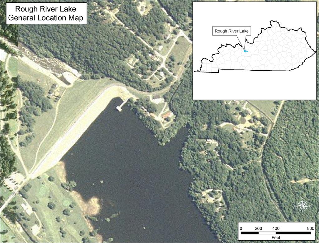
2 Spillway
3 ROUGH RIVER LAKE PERTINENT DATA Construction Completed Sept 1959 Spillway Crest 524 ft msl Probable Maximum Flood Total Precip in 48 hrs Elevation of Pool at Start of flood (routing of 1937 flood) Maximum Water Surface Elevation Top of Dam 27.6 inches 503 ft msl ft msl ft msl
4 Engineering Regulation (FR) Inflow Design Floods for Dams and Reservoirs For Ohio River Basin Antecedent Flood 30% of PMF w/ 3 Dry Days or 39% of PMF w/ 5 Dry Days
5 Engineering Regulation Policy: Dam Safety Assurance Program Dam Safety Modifications related to Hydrologic Deficiencies should be recommended to meet or exceed the Base Safety Condition (BSC). The BSC is met when Dam failure will result in no significant increase in loss of life or economic damages compared to without Dam failure.
6 GUIDELINES for EVALUATING MODIFICATIONS OF EXISTING DAMS RELATED TO HYDROLOGIC DEFICIENCIES OFFICE OF THE CHIEF OF ENGINEERS U.S. Army Engineer Institute for Water Resources September 1986 IWR Report 86-R-7
7 EVALUATING MODIFICATIONS OF EXISTING DAMS RELATED TO HYDROLOGIC DEFICIENCIES SEVENTEEN STEP PHASE Steps Determine if the existing Dam is Hydrologically deficient based upon the latest IWR guidelines Steps If these Dams are Hydrologically deficient, focus on the evaluation of alternative measures which can provide the required level of Dam safety.
8 Step 1 - Describe the Physical Project Characteristics a) Summarize and display the physical features of the project b) Describe the physical features of the project c) Describe the operations and use of the project d) Describe the economic development upstream and downstream of the Dam
9 Step 2 - Determination of the Existing Threshold Flood 1) The Threshold flood is that flood that results in a peak lake water surface elevation equal to the top of Dam less appropriate freeboard. ExpressedE as % of the PMF. 2) Assume an antecedent flood begins 5 days prior to the onset of the Threshold flood and is 50% of the following Threshold flood. or Assume antecedent flood is 30% of the Threshold flood with 3 days s dry period or 39% of Threshold flood with 5 days dry period for Ohio River Basin.
10 560 Determination of Threshold Flood (as calculated by HEC-HMS) Top of Dam 550 Top of Dam less freeboard 0.87 PMF 540 Elevation (feet MSL) 530 Maximum Pool Elevation Designed By: Staci Ogle Checked By: Andy Low e 10/03 Final Design Flood as Proportion of PMF
11 Combined Spillway and Conduit Discharge Reservoir Inflow Pool Elevation Top of Dam (Elev. 554) Discharge (cfs) Pool Elevation (ft above m sl) 510 Draw n By: Staci Ogle Checked By: Andy Low e Rough River DSAPReport Final 2/ /1/03 0:00 3/3/03 0:00 3/5/03 0:00 3/7/03 0:00 3/9/03 0:00 3/11/03 0:00 3/13/03 0:00 3/15/03 0:00 3/17/03 0:00 3/19/03 0:00 3/21/03 0: Flood Duration
12 Step 3 - Determine total flows and downstream inundation elevations from the Threshold Flood with and without dam failure and from lesser floods. The results of this step will be used to produce inundation maps for the evaluation of potential fatalities and economic losses. DAM BREACH MODELS: 1. HEC-RAS 2. NWS DAMBRK 3. FLDWAV 4. HEC-1; HEC-HMS 5. BREACH TRAINING: October 25-27, 2005 Salt Lake City, Utah FEMA/ Association of State Dam Safety Officials Susan Sorrell (859)
13 Dam Break Model Parameters Initial Reservoir Water Surface Elevation Water Surface Elevation at Time of Breach Breach Side Slope Stream Bed Elevation Final Breach Bottom Elevation Breach Base Width Time of Breach Formation 495 (Summer Pool) 554 (Top of Dam) 1: feet 6 hours
14 Step 4 Compute the hypothetical maximum Dam failure flows and downstream inundation elevations. Purpose To determine the maximum lateral boundaries for the collection of data on economic and life losses for the succeeding steps.
15 Step 5 Prepare inundation maps and collect data on damageable property and populations for the hypothetical maximum flooding determined in Step 4. PURPOSE Requires the collection of data for use in estimating economic flood losses and life losses.
16 Dam
17 Study: Rough River Description: Rough River DamSafetyStudy Pathname: C:\Documents and Settings\h2pmpklm\MyDocuments\HEC\FDA\Rough River Plan: Without Year: 2003 Struc_Name Stream_Name Station Bank Year Cat_Name Occ_Name Structure Name StreamName Reach Name Station Bank Year In Service Damage Category Occupancy 1 Rough River Gray-Co 0.16 Left -901 PUBLIC PUBL 2 Rough River Gray-Co 0.16 Left -901 PUBLIC PUBL 3 Rough River Gray-Co 0.2 Left -901 PUBLIC PUBL 4 Rough River Gray-Co 5.2 Left -901 Residential 7 5 Rough River Gray-Co 5.2 Left -901 Residential 2 6 Rough River Gray-Co 5.2 Left -901 Residential 5 7 Rough River Gray-Co 5.2 Left -901 COMM WARE 8 Rough River Gray-Co 5.2 Left -901 Residential 2 9 Rough River Gray-Co 5.3 Left -901 Residential 1 10 Rough River Gray-Co 5.4 Left -901 Residential 7 11 Rough River Gray-Co 5.4 Left -901 Residential 7
18 Step 6 Prepare inundation maps for the Threshold flood with & without Dam failure. This information will be used to determine economic flood losses and the population threatened by failure and non-failure floods.
19 Existing Condition Inundation Elevation for the Threshold Flood Dam Failure and Dam Non-failure (as calculated by Boss DamBrk Program) Threshold Flood (Failure) Threshold Flood (Non-failure) Thalweg Elevation (ft) DesignedBy:Staci Ogle CheckedBy:Andy Lowe 10/03 Final Distance from Dam (mi)
20 Elevation (ft) PMF 0.6 PMF 0.4 PMF 0.2 PMF Thalweg Designed By: Staci Ogl e Checked By: Andy Lowe 10/ 03 F i n a l Distance from Dam (mi)
21 Step 7 Determine population at risk (PAR) from the Threshold flood and lesser events. Population at Risk defined as all persons that would be exposed to flood waters if they took no measures to evacuate. PAR will be used to estimate the Threatened Population (TP) and Loss of Life (LOL). PAR varies for time of day (daily transients). PAR varies for time of year (seasonal transients).
22 ROUGH RIVER LAKE Average daily traffic counts were obtained in the study area for both low-severity zones and medium-severity zones to estimate transient motorist population at risk.
23 Step 8 Determine economic losses from Threshold flood and specified lesser floods. If economic losses are significantly greater with Dam failure than losses without failure, an investment to improve the safety of the Dam may be warranted. TYPES OF LOSSES: a) Residential structure & contents b) Commercial and industrial structure & contents c) Agricultural losses d) Income losses e) Damage to utilities, transportation & communication systems f) Vehicles g) Flood emergency costs h) Project benefits lost with failure i) Culture & environmental assets j) Physical & psychological injuries
24 Total PAR Total Econ. Losses Dam Non-failure 139 $1,867,000 Dam Failure 1,367 $17,833,000
25 Step 9 Determination of Dam failure warning time. The estimated warning time will be used to estimate the threatened population in step 10 as well as the loss of life. Threatened Population all those likely to be exposed to floodwaters assuming that warnings have been issued.
26 ROUGH RIVER LAKE ANALYSIS The minimum warning time for a potential Dam failure is greater than 60 minutes.
27 Step 10 Estimate the baseline probable PAR, probable TP, and probable LOL from the Threshold flood and specified lesser floods. At the time of this IWR report, it is stated There is no generally accepted method of estimating the effectiveness of warning to calculate the probable TP and probable LOL.
28 Flood Severity Warning Time (min) Flood Severity Understanding* Fatality Rate (Fraction of People at Risk Expected to Die) Suggested Suggested Range High No Warning N/A to to 60 More than 60 Vague Precise Vague Precise Use the values shown above and apply to the number of people who remain in the dam failure floodplain after warnings are issued. No guidance is provided on how many people will remain in the floodplain. Medium No Warning N/A to to 60 Vague to 0.08 More than 60 Precise to 0.04 Vague to 0.06 Precise to 0.02 Low No Warning N/A to to 60 Vague to More than 60 Precise to Vague to Precise to Bureau of Reclamations *It was assumed that half the PAR would have a vague understanding of the resulting flood severity and the other half would have a precise understanding.
29 Step 11 Display existing condition results and propose additional action. If there is a significant increment in economic losses or probable LOL due to Dam failure, additional study of alternatives to reduce the extent of the Dam safety hazard is warranted.
30 Total PAR Total Econ. Losses Dam Non-failure 139 $1,867,000 Dam Failure 1,367 $17,833,000
31 Step 12 Identify alternatives to reduce the Dam safety hazard to people and property. Alternatives should be based on percentages of the PMF, such as.80,.90 and 1.00 PMF. ALTERNATIVES COULD INCLUDE: a) Raising the top of Dam b) Lowering/widening the Spillway c) Reallocation of Reservoir storage d) Permanent relocation of downstream population e) Additional reservoirs f) Additional Spillway capacity g) FWEEPS
32 LIST OF ROUGH RIVER LAKE Widen spillway ALTERNATIVES Raise Dam in combination with wall Use Fusegates to lower spillway Combination of fusegates and wall
33 Step 13 Evaluate the costs of BSC modification alternatives. Total Cost Widen spillway by 85 feet Raise dam by 2 feet; construct 3-foot3 parapet wall across upstream crest Deepen spillway by 20 feet; install Fusegates Deepen spillway by 10 feet; install Fusegates construct 3-foot3 parapet wall $5,109,500 $1,433,000 $3,896,500 $3,147,700
34 Step 14 Evaluate alternatives in terms of their effectiveness in reducing the hazard. The method used for evaluating the alternatives follows the same steps as existing conditions as listed in steps Their effectiveness is measured in PAR and economic losses.
35 Step 15 Determination of the Base Safety Condition (BSC). If there is a significant increment in economic & probable LOL losses at the Threshold Flood, The Dam must be designed to safely pass a larger flood that meets a Base Safety Condition (BSC). BSC-Flood event where there is no significant increase in loss of life or economic losses from Dam failure compared to without Dam failure.
36 INCREMENTS (IN FEET) OF DAM CREST ELEVATION Threshold Flood = With DamFailure 1100 Population at Risk (PAR Without Dam Failure Design Floods as Proportion of PMF
37 $22,000 + INCREMENTS (IN FEET) OF DAM CREST ELEVATION $20,000 Threshold Flood = $18, With DamFailure $16,000 Economic Losses (Thousands) $14,000 $12,000 $10,000 $8,000 $6,000 $4,000 Draw n by: Staci Ogle Checked by: Andy Low e $2,000 Rough River, KY D S f t A * $ Design Floods as Proportion of PMF Without Dam Failure
38
39 Step 16 Recommend Choice of alternatives to meet BSC. In general, the lowest-cost alternative meeting the BSC should be recommended for implementation. The BSC, by definition, is never greater than the PMF. Provide a summary of the documentation of the evaluation process and to recommend a Dam safety modification for implementation.
40
41 Step 17 Determination of whether breaching the Dam should be evaluated as an alternative. If the benefits of continued operation of the lake project do not exceed the costs for modification, consideration should be given to breaching the Dam.
42 ROUGH RIVER LAKE RECOMMENDED MODIFICATION Cost = $1,433,000 Benefit to Cost Ratio = 76 to 1
The AIR Inland Flood Model for Great Britian
 The AIR Inland Flood Model for Great Britian The year 212 was the UK s second wettest since recordkeeping began only 6.6 mm shy of the record set in 2. In 27, the UK experienced its wettest summer, which
JANUARY 13, ILL. ADM. CODE CH. I, SEC TITLE 17: CONSERVATION CHAPTER I: DEPARTMENT OF NATURAL RESOURCES SUBCHAPTER h: WATER RESOURCES
 TITLE 17: CONSERVATION CHAPTER I: DEPARTMENT OF NATURAL RESOURCES SUBCHAPTER h: WATER RESOURCES PART 3702 CONSTRUCTION AND MAINTENANCE OF DAMS Section Page No. 3702.10 Purpose 2 3702.20 Definitions 3 3702.30
CRISP COUNTY, GEORGIA AND INCORPORATED AREAS
 CRISP COUNTY, GEORGIA AND INCORPORATED AREAS Community Name Community Number ARABI, CITY OF 130514 CORDELE, CITY OF 130214 CRISP COUNTY (UNINCORPORATED AREAS) 130504 Crisp County EFFECTIVE: SEPTEMBER 25,
SUBJECT: EXECUTIVE DIRECTOR'S REPORT FOR JANUARY 19, 2017 WATER INFRASTRUCTURE IMPROVEMENTS FOR THE NATION (WIIN) ACT
 ACT") ITEM 2 Agenda of January 19, 2017 TO: FROM: Board of Directors Sacramento Area Flood Control Agency Richard M. Johnson, Executive Director (916) 874-7606 SUBJECT: EXECUTIVE DIRECTOR'S REPORT FOR JANUARY
ITEM 2 Agenda of January 19, 2017 TO: FROM: Board of Directors Sacramento Area Flood Control Agency Richard M. Johnson, Executive Director (916) 874-7606 SUBJECT: EXECUTIVE DIRECTOR'S REPORT FOR JANUARY
Upper Joachim Creek Public Survey on Potential Flood Risk Reduction
 Upper Joachim Creek Public Survey on Potential Flood Risk Reduction This survey is intended to help the interagency planning committee to receive public feedback on specific flood risk reduction techniques,
Requirements for Mapping Levees Complying with Section of the NFIP Regulations
 FACT SHEET Requirements for Mapping Levees Complying with Section 65.10 of the NFIP Regulations As part of a mapping project, it is the levee owner s or community s responsibility to provide data and documentation
FREQUENTLY ASKED QUESTION ABOUT FLOODPLAINS Michigan Department of Environmental Quality
 FREQUENTLY ASKED QUESTION ABOUT FLOODPLAINS Michigan Department of Environmental Quality WHAT IS A FLOOD? The National Flood Insurance Program defines a flood as a general and temporary condition of partial
Kentucky Division of Water Permitting Floodplain Overview and Considerations
 Kentucky Division of Water Permitting Floodplain Overview and Considerations Presentation to: 2014 KAMM Conference Lake Barkley State Resort Park by Solitha Dharman Department for Environmental Protection
Action Items for Flood Risk Management on Wildcat Creek Interagency success with floodplain management plans and flood forecast inundation maps
 Presentation to USACE 2012 Flood Risk Management and Silver Jackets Joint Workshop, Harrisburg, Pennsylvania Action Items for Flood Risk Management on Wildcat Creek Interagency success with floodplain
Delaware River Basin Commission s Role in Flood Loss Reduction Efforts
 Delaware River Basin Commission s Role in Flood Loss Reduction Efforts There is a strong need to reduce flood vulnerability and damages in the Delaware River Basin. This paper presents the ongoing role
BRITISH COLUMBIA DAM SAFETY REGULATION 44/2000
 PDF Version [Printer friendly ideal for printing entire document] BRITISH COLUMBIA DAM SAFETY REGULATION 44/2000 Published by Important: Quickscribe offers a convenient and economical updating service
UPDATE ON DALLAS FLOODWAY
 UPDATE ON DALLAS FLOODWAY ENVIRONMENTAL IMPACT STATEMENT [ EIS ] Transportation and Trinity River Project Committee Rob Newman Director, Trinity River Corridor Project, Fort Worth District 28 April 2014
Floodplain Management Annual Conference Atlanta, Georgia April 2017
 Floodplain Management 2017 Annual Conference Atlanta, Georgia April 2017 Floodplain Mapping and Flood Zones Zone Deisgnations: Zone A: No base flood elevations have been determined it is an approximated
DEPARTMENT OF WATER AFFAIRS. No. R February 2012 NATIONAL WATER ACT, 1998
 STAATSKOERANT, 24 FEBRUARIE 2012 No. 35062 3 GOVERNMENT NOTICE DEPARTMENT OF WATER AFFAIRS No. R. 139 24 February 2012 NATIONAL WATER ACT, 1998 REGULATIONS REGARDING THE SAFETY OF DAMS IN TERMS OF SECTION
(24 February to date) NATIONAL WATER ACT 36 OF (Gazette No , Notice No See Act for commencement dates)
 NATIONAL WATER ACT 36 OF (Gazette No , Notice No See Act for commencement dates)") (24 February 2012 - to date) NATIONAL WATER ACT 36 OF 1998 (Gazette No. 19182, Notice No. 1091. See Act for commencement dates) REGULATIONS REGARDING THE SAFETY OF DAMS IN TERMS OF SECTION 123(1) OF THE
(24 February 2012 - to date) NATIONAL WATER ACT 36 OF 1998 (Gazette No. 19182, Notice No. 1091. See Act for commencement dates) REGULATIONS REGARDING THE SAFETY OF DAMS IN TERMS OF SECTION 123(1) OF THE
Trinity River Restoration Program
 Trinity River Restoration Program Trinity River Bridges: Hydraulic, Scour, and Riprap Sizing Analysis US DEPARTMENT OF THE INTERIOR BUREAU OF RECLAMATION TECHNICAL SERVICE CENTER Prepared by Kent L. Collins
SECTION 9: MAPS AND DATA
 SECTION 9: MAPS AND DATA Contents 9.1. NFIP Maps and Data... 9-2 9.1.1. Adopting and enforcing NFIP floodplain maps and data... 9-2 9.1.2. Adopting and enforcing more restrictive data... 9-2 9.1.3. Annexations...
Chapter 5 Floodplain Management
 Chapter 5 Floodplain Management Contents 1.0 Introduction... 1 2.0 Floodplain Management and Regulation... 1 2.1 City Code... 1 2.2 Floodplain Management... 1 2.3 Level of Flood Protection... 2 2.3.1 Standard
Plan Title: Proposed(24x48 beam) Plan File : h:\padot 8-0\SR York\Str\Design\H&H\2002\SR4017.p05
 Plan File : h:\padot 8-0\SR York\Str\Design\H&H\2002\SR4017.p05") HEC-RAS September 1998 Version 2.2 U.S. Army Corp of Engineers Hydrologic Engineering Center 609 Second Street, Suite D Davis, California 95616-4687 (916) 756-1104 X X XXXXXX XXXX XXXX XX XXXX X X X X
HEC-RAS September 1998 Version 2.2 U.S. Army Corp of Engineers Hydrologic Engineering Center 609 Second Street, Suite D Davis, California 95616-4687 (916) 756-1104 X X XXXXXX XXXX XXXX XX XXXX X X X X
Subject: Upper Merrimack and Pemigewasset River Study Task 9 - Water Supply Evaluation
 Memorandum To: From: Barbara Blumeris, USACE Ginger Croom and Kirk Westphal, CDM Date: April 14, 2008 Subject: Upper Merrimack and Pemigewasset River Study Task 9 - Water Supply Evaluation Executive Summary
Federal Emergency Management Agency
 Page 1 of 6 Issue Date: September 27, 2010 Effective Date: February 14, 2011 Follows Conditional Case No.: 08-08-0873R DETERMINATION DOCUMENT COMMUNITY AND REVISION INFORMATION PROJECT DESCRIPTION BASIS
The City of El Paso APPENDIX D DAM RISK INVENTORY ASSESSMENT
 APPENDIX D DAM RISK INVENTORY ASSESSMENT March 2009 Appendix D - Dam Risk Inventory Assessment Section Table of Contents Page D.1.0 DAM RISK INVENTORY ASSESSMENT... 1 D.1.1 Methodology... 1 D.1.2 Dam
INSTRUCTIONS FOR COMPLETING THE APPLICATION FORMS FOR CONDITIONAL LETTERS OF MAP REVISION AND LETTERS OF MAP REVISION
 INSTRUCTIONS FOR COMPLETING THE APPLICATION FORMS FOR CONDITIONAL LETTERS OF MAP REVISION AND LETTERS OF MAP REVISION GENERAL In 1968, the U.S. Congress passed the National Flood Insurance Act, which created
The AIR Inland Flood Model for the United States
 The AIR Inland Flood Model for the United States In Spring 2011, heavy rainfall and snowmelt produced massive flooding along the Mississippi River, inundating huge swaths of land across seven states. As
10526 Bermuda Isle Dr. Tampa, FL 33647
 Flood Analysis Memo Property Address 10526 Bermuda Isle Dr. In Partnership with: ** This property is NOT within a high-risk flood zone ** 10526 Bermuda Isle Dr. BFE = 35 ft This property is located in
Non Regulatory Risk MAP Products Flood Depth and Probability Grids
 Non Regulatory Risk MAP Products Flood Depth and Probability Grids Virginia Floodplain Management Association 2015 Floodplain Management Workshop October 29th, 2015 Nabil Ghalayini, P.E., PMP, D.WRE, CFM
Development Fee Program: Comparative risk analysis
 Development Fee Program: Comparative risk analysis January 2008 Sacramento Area Flood Control Agency David Ford Consulting Engineers, Inc. 2015 J Street, Suite 200 Sacramento, CA 95811 Ph. 916.447.8779
APPENDIX E ECONOMICS
 APPENDIX E ECONOMICS American River Watershed Common Features General Reevaluation Report Draft Economics Appendix E February 2015 Cover Photos courtesy of the Sacramento District: Sacramento Weir during
Chapter 6 - Floodplains
 Chapter 6 - Floodplains 6.1 Overview The goal of floodplain management is to reduce the potential risks to both existing and future developments, and infrastructure, in the 100-year floodplain. Over the
SR-210 MIXED FLOW LANE ADDITION PROJECT EA NO. 0C7000 FROM HIGHLAND AVENUE TO SAN BERNARDINO AVENUE. Prepared for. December 2012.
 S A N T A A N A R I V E R L O C A T I O N H Y D R A U L I C S T U D Y SR-210 MIXED FLOW LANE ADDITION PROJECT FROM HIGHLAND AVENUE TO SAN BERNARDINO AVENUE EA NO. 0C7000 Prepared for San Bernardino Associated
Vocabulary of Flood Risk Management Terms
 USACE INSTITUTE FOR WATER RESOURCES Vocabulary of Flood Risk Management Terms Appendix A Leonard Shabman, Paul Scodari, Douglas Woolley, and Carolyn Kousky May 2014 2014-R-02 This is an appendix to: L.
GENERAL PLAN AMENDMENT # FLOOD HAZARDS
 GENERAL PLAN AMENDMENT #2011-03 FLOOD HAZARDS The following text that appears on pages HS 3-4 of the Health and Safety Element in the Yolo 2030 Countywide General Plan has been amended. New language is
NFIP Program Basics. KAMM Regional Training
 NFIP Program Basics KAMM Regional Training Floodplain 101 Homeowners insurance does not cover flood damage Approximately 25,000 flood insurance policies in KY According to BW12 analysis, approximately
Section 19: Basin-Wide Mitigation Action Plans
 Section 19: Basin-Wide Mitigation Action Plans Contents Introduction...19-1 Texas Colorado River Floodplain Coalition Mitigation Actions...19-2 Mitigation Actions...19-9 Introduction This Mitigation Plan,
Public Information Meeting Rahway River Basin, New Jersey Flood Risk Management Feasibility Study
 Public Information Meeting Rahway River Basin, New Jersey Flood Risk Management Feasibility Study U.S. Army Corps of Engineers, New York District New Jersey Department of Environmental Protection 11 &
Appendix D - Floodplain Documents
 City of Aspen Urban Runoff Management Plan Appendix D - Floodplain Documents 1. Floodplain Development Permit 2. Elevation Certificate and Instructions 3. Floodproofing Certificate for Non-Residential
Scottish Planning Policy (SPP) Compensatory Flood Storage / Flood Mitigation
 Compensatory Flood Storage / Flood Mitigation") Scottish Planning Policy (SPP) Compensatory Flood Storage / Flood Mitigation Marc Becker SEPA Flood Unit Manager Joint SHG / SHGS meeting 8 th September 2010 Smith Art Gallery and Museum, Dumbarton Road,
Scottish Planning Policy (SPP) Compensatory Flood Storage / Flood Mitigation Marc Becker SEPA Flood Unit Manager Joint SHG / SHGS meeting 8 th September 2010 Smith Art Gallery and Museum, Dumbarton Road,
Situation: the need for non-structural flood risk reduction measures
 Evaluating benefits of non-structural measures in flood risk management feasibility studies At left: Example of a house on an open foundation Source Asheville, NC (undated) By Steve Cowdin, CFM; Natalie
PROJECT DATA Project Title: Modena Union Street Bridge Project File : unionst.prj Run Date and Time: 9/6/03 7:47:22 AM. Project in English units
 HEC-RAS Version 3.1 November 2002 U.S. Army Corp of Engineers Hydrologic Engineering Center 609 Second Street, Suite D Davis, California 95616-4687 (916) 756-1104 X X XXXXXX XXXX XXXX XX XXXX X X X X X
DECATUR COUNTY, GEORGIA AND INCORPORATED AREAS
 DECATUR COUNTY, GEORGIA AND INCORPORATED AREAS Community Name Community Number ATTAPULGUS, CITY OF 130541 BAINBRIDGE, CITY OF 130204 BRINSON, TOWN OF 130670 CLIMAX, CITY OF 130542 DECATUR COUNTY (UNINCORPORATED
Corps Water Management System (CWMS)
") Corps Water Management System (CWMS) Real-Time Decision Support Modeling & Mapping Inter-Agency Flood Risk Characterization Workshop Christopher N. Dunn, P.E., D. WRE, Director Hydrologic Engineering Center
Corps Water Management System (CWMS) Real-Time Decision Support Modeling & Mapping Inter-Agency Flood Risk Characterization Workshop Christopher N. Dunn, P.E., D. WRE, Director Hydrologic Engineering Center
Table 1: Federal, State and Local Government Rules applicable to LOMRs/CLOMRS submittal
 MnDNR LOMC Guide This document has been prepared by the Minnesota Department of Natural Resources floodplain staff and is intended to provide assistance with LOMR/CLOMR submittals. This information is
Justification for Floodplain Regulatory Standards in Illinois
 Justification for Floodplain Regulatory Standards in Illinois Office of Water Resources Issue Paper April, 2015 Proactive Illinois floodplain and floodway regulatory standards have prevented billions of
ATTACHMENT 1. Amendments to Chapter 18.20, Definitions Area of shallow flooding Area of special flood hazard
 Amendments to Chapter 18.20, Definitions 18.20.206 Area of shallow flooding Area of shallow flooding means a designated AO, or AH, AR/AO, AR/AH, or VO Zone on the a community's flood insurance rate map
Mill Creek Floodplain Proposed Bylaw Frequently Asked Questions
 Mill Creek Floodplain Proposed Bylaw Frequently Asked Questions Q: What is a Floodplain Bylaw? A: A Floodplain Bylaw is a flood hazard management tool to ensure future land use will be planned and buildings
Skagit County Flood Insurance Study Update. Ryan Ike, CFM FEMA Region 10
 Skagit County Flood Insurance Study Update Ryan Ike, CFM FEMA Region 10 Skagit County Flood Insurance Study Process Overview Process, Schedule, & Deliverables Base Flood Elevations, Modeling, & Levees
Interagency Nonstructural Flood Risk Management Workshop. Carey Johnson Kentucky Division of Water
 Interagency Nonstructural Flood Risk Management Workshop Carey Johnson Kentucky Division of Water Nonstructural Flood Risk Management Nonstructural floodproofing Elevation Relocation Buyout/acquisition
If you have any questions or require additional information, please feel free to contact me.
 July 12, 2018 Attn: Matt Siekielski NexBank SSB 2515 McKinney Ave, Ste 1100 Dallas, Texas 75201 Re: Flood Reclamation Feasibility Study - Limited Mr. Siekielski, We have completed a limited flood reclamation
CHAPTER 15: FLOODPLAIN OVERLAY DISTRICT "FP"
 CHAPTER 15: FLOODPLAIN OVERLAY DISTRICT "FP" SECTION 15.1 STATUTORY AUTHORIZATION The legislature of the State of Minnesota in Minnesota Statutes, Chapter 103F and Chapter 394 has delegated the responsibility
DuPage County East Branch DuPage River Resiliency Project. Benefit Cost Analysis
 DuPage County East Branch DuPage River Resiliency Project Benefit Cost Analysis 1.0 Benefit Cost Analysis Preparation The BCA for this proposal was a collaborative effort between DuPage County, V3 engineering
HOLMES COUNTY, FLORIDA AND INCORPORATED AREAS
 HOLMES COUNTY, FLORIDA AND INCORPORATED AREAS Community Name Community Number BONIFAY, CITY OF 120116 ESTO, TOWN OF 120630 HOLMES COUNTY (UNINCORPORATED AREAS) 120420 NOMA, TOWN OF 120631 PONCE DE LEON,
Dealing With Unnumbered A Zones in Maine Floodplain Management
 Dealing With Unnumbered A Zones in Maine Floodplain Management The following is a list of acceptable methods that the State Floodplain Management Coordinator and the Federal Emergency Management Agency
210 W Canal Dr Palm Harbor, FL 34684
 Flood Analysis Memo Property Address In Partnership with: ** This property is within a high risk flood zone ** BFE = 6 ft This property is located in the FEMA designated high-risk zone, Zone AE - an area
ENGINEERING AND CONSTRUCTION BULLETIN
 ENGINEERING AND CONSTRUCTION BULLETIN No. 2016-8 Issuing Office: CECW-CE Issued: 22 Feb 16 Expires: 22 Feb 18 SUBJECT: Interim Risk Reduction Measures (IRRMs) for Levee Safety CATEGORY: Directive and Policy
7. Understand effect of multiple annual exposures e.g., 30-yr period and multiple independent locations yr event over 30 years 3%
 I. FLOOD HAZARD A. Definition 1. Hazard: probability of water height 2. At a Specific XY floodplain location; 3. Z can be expressed as elevation (NAVD88); gauge height; height above ground (depth). 4.
Federal Emergency Management Agency
 Page 1 of 4 Issue Date: October 2, 2017 Effective Date: October 2, 2017 Case No.: 17-09-2731P LOMR-APP Federal Emergency Management Agency Washington, D.C. 20472 LETTER OF MAP REVISION DETERMINATION DOCUMENT
Frequently Asked Questions Oxbow / Hickson / Bakke Ring Levee Option
 Frequently Asked Questions Oxbow / Hickson / Bakke Ring Levee Option October 16, 2012 Q1. Why has the position on a ring-levee changed? The feasibility study recommended buy-outs for areas with staging
10526 Bermuda Isle Dr. Tampa, FL 33647
 Flood Analysis Memo Property Address In Partnership with: ** This property is NOT within a high-risk flood zone ** This property is located in a FEMA low-risk zone designated as Zone X - an area of minimal
FINAL TECHNICAL MEMORANDUM AWD FLOWS THROUGH FLOOD DAMAGE REDUCTION AREA July 16, 2012
 FINAL TECHNICAL MEMORANDUM AWD-00002 FLOWS THROUGH FLOOD DAMAGE REDUCTION AREA July 16, 2012 Table of Contents TABLE OF CONTENTS Table of Contents... 1 Executive Summary... 2 1 Objective... 4 2 Study Approach...
Planning Process---Requirement 201.6(b): An open public involvement process is essential to the development of an effective plan.
: An open public involvement process is essential to the development of an effective plan.") Section 3 Capability Identification Requirements Planning Process---Requirement 201.6(b): An open public involvement process is essential to the development of an effective plan. Documentation of the Planning
Section 3 Capability Identification Requirements Planning Process---Requirement 201.6(b): An open public involvement process is essential to the development of an effective plan. Documentation of the Planning
Mapping flood risk its role in improving flood resilience in England
 Mapping flood risk its role in improving flood resilience in England Catherine Wright Director of Digital and Skills Flood and Coastal Risk Management Environment Agency 6 October 2017 The Environment
New Tools for Mitigation & Outreach. Louie Greenwell Stantec
 New Tools for Mitigation & Outreach Louie Greenwell Stantec Our Discussion Today Background What is Risk MAP? FEMA Products Overview of RiskMAP Data Sets Changes Since Last FIRM Depth and Analysis Grids
The maximum allowable valley storage decrease for the 100-year flood and Standard Project Flood are 0.0% and 5.0%, respectively.
 2.1.1.2 HYDRAULIC IMPACTS VALLEY The maximum allowable valley storage decrease for the 100-year flood and Standard Project Flood are 0.0% and 5.0%, respectively. General. The computation of valley storage
Comprehensive Flood Mitigation for 12,000 Properties
 Comprehensive Flood Mitigation for 12,000 Properties Lori Rafferty, PE, CFM, Louisville MSD & Louie Greenwell, GISP, CFM, T&M Associates Association of State Floodplain Managers 2014 State Conference June
ASFPM Partnerships for Statewide Mitigation Actions. Alicia Williams GIS and HMP Section Manager, Amec Foster Wheeler June 2016
 ASFPM Partnerships for Statewide Mitigation Actions Alicia Williams GIS and HMP Section Manager, Amec Foster Wheeler June 2016 Summary The Concept Leveraging Existing Data and Partnerships to reduce risk
Appendix D Economic Analysis
 Westchester County Streams, Byram River Basin Flood Risk Management Fairfield County, Connecticut and Westchester County, New York Draft Integrated Feasibility Report & Environmental Impact Statement Appendix
BUTTS COUNTY, GEORGIA AND INCORPORATED AREAS
 BUTTS COUNTY, GEORGIA AND INCORPORATED AREAS Butts County Community Name Community Number BUTTS COUNTY (UNICORPORATED AREAS) 130518 FLOVILLA, CITY OF 130283 JACKSON, CITY OF 130222 JENKINSBURG, TOWN OF
Federal Emergency Management Agency
 Page 1 of 5 Issue Date: June 21, 2013 Follows Conditional Case No.: 04-06-A148R DETERMINATION DOCUMENT COMMUNITY COMMUNITY AND REVISION INFORMATION City of Irving Dallas County Texas FILL PROJECT DESCRIPTION
Rebuilding Flood-Conscious Societies
 Report on Flood Disaster Risk Reduction against Large-Scale Inundations Rebuilding Flood-Conscious Societies through Awareness-raising December 2015 Council for Social Infrastructure Development 1 Contents
Federal Emergency Management Agency
 Page 1 of 4 Issue Date: April 26, 2013 DETERMINATION DOCUMENT COMMUNITY AND REVISION INFORMATION PROJECT DESCRIPTION BASIS OF REQUEST City of Coppell Dallas County Texas FILL HYDRAULIC ANALYSIS NEW TOPOGRAPHIC
Good Practice Guide. GPG 101 Document Owner: Steve Cook. Page 1 of 7.
 Good Practice Guide Producing flood risk hydraulic models and flood consequence assessments for development planning purposes Date Published: September 2015 GPG 101 Document Owner: Steve Cook Page 1 of
SEQWATER PORTFOLIO RISK ASSESSMENT AND MANAGEMENT
 SEQWATER PORTFOLIO RISK ASSESSMENT AND MANAGEMENT BARTON MAHER PRINCIPAL STORAGE PLANNING SEQWATER AUSTRALIA THE WHOLE POINT OF RISK ASSESSMENT SEQWATER DOWN UNDER WHERE WE OPERATE One of Australia s largest
DES MOINES CITY OF TWO RIVERS. Flooding Risk & Impact to Development
 DES MOINES CITY OF TWO RIVERS Flooding Risk & Impact to Development River System Des Moines Flood Protection Des Moines Flood Protection cont. Infrastructure Over 24 miles of levees 21stormwater pump stations
Floodplain Management 101: UNIT II. Maps & Flood Insurance Studies
 Floodplain Management 101: UNIT II Maps & Flood Insurance Studies Who is ASFPM? ASFPM stands for the Association of State Floodplain Managers A national organization of floodplain management professionals
FLOOD HAZARD AND RISK MANAGEMENT UTILIZING HYDRAULIC MODELING AND GIS TECHNOLOGIES IN URBAN ENVIRONMENT
 Proceedings of the 14 th International Conference on Environmental Science and Technology Rhodes, Greece, 3-5 September 2015 FLOOD HAZARD AND RISK MANAGEMENT UTILIZING HYDRAULIC MODELING AND GIS TECHNOLOGIES
Frequently Asked Questions (FAQs)
") FLOODS Floods are one of the most common hazards in the United States. Flood effects can be local, impacting a neighborhood or community, or very large, affecting entire river basins and multiple states.
FLOODS Floods are one of the most common hazards in the United States. Flood effects can be local, impacting a neighborhood or community, or very large, affecting entire river basins and multiple states.
Technical Memorandum 3.4 E Avenue NW Watershed Drainage Study. Appendix E Floodplain Impacts and Implications Memo
 Technical Memorandum 3.4 E Avenue NW Watershed Drainage Study Appendix E Floodplain Impacts and Implications Memo September 8, 2017 City of Cedar Rapids E Avenue Watershed Drainage Study Memo Date: Tuesday,
Floodplain Management 101. Mississippi Emergency Management Agency Floodplain Management Bureau
 Floodplain Management 101 Mississippi Emergency Management Agency Floodplain Management Bureau Stafford Act The Stafford Disaster Relief and Emergency Assistance Act (Stafford Act) (Public Law 100-707)
SENECA COUNTY, OHIO AND INCORPORATED AREAS
 SENECA COUNTY, OHIO AND INCORPORATED AREAS COMMUNITY NAME COMMUNITY NUMBER ATTICA, VILLAGE OF* 390991 BETTSVILLE, VILLAGE OF 390500 BLOOMFIELD, VILLAGE OF* 390989 NEW RIEGEL, VILLAGE OF* 390990 REPUBLIC,
Downstream Consequence of Failure Classification Interpretation Guideline
 Downstream Consequence of Failure Classification Interpretation Guideline Dam Safety Program Ministry of Forests, Lands and Natural Resource Operations Revised March 2017 Table of Contents Introduction...
DAM SAFETY RISK MANAGEMENT FOR HYDROELECTRIC PROJECTS
 DAM SAFETY RISK MANAGEMENT FOR HYDROELECTRIC PROJECTS DAVID S. BOWLES Professor and Director Institute for Dam Safety Risk Management Utah State University Logan, Utah, U.S.A. Managing Principal RAC Engineers
Model Development to Support Assessment of Flood Risk for the Columbia River Treaty Review
 Model Development to Support Assessment of Flood Risk for the Columbia River Treaty Review 2012 AWRA Washington State Conference Sara Marxen, P.E. U.S. Army Corps of Engineers Seattle District September,
SR-210 MIXED FLOW LANE ADDITION PROJECT EA NO. 0C7000 FROM HIGHLAND AVENUE TO SAN BERNARDINO AVENUE. Prepared for. December 2012.
 C I T Y C R E E K L O C A T I O N H Y D R A U L I C S T U D Y SR-210 MIXED FLOW LANE ADDITION PROJECT FROM HIGHLAND AVENUE TO SAN BERNARDINO AVENUE EA NO. 0C7000 Prepared for San Bernardino Associated
LIFE SAFETY HAZARD INDICATOR
 LIFE SAFETY HAZARD INDICATOR Background The Life Safety Hazard Indicator (LSHI) is a value that represents the relative potential loss of life for a specific flood scenario. The LSHI is a screening level
Mapping Flood Risk in the Upper Fox River Basin:
 Mapping Flood Risk in the Upper Fox River Basin: Vulnerable Populations and Adverse Health Effects Presented by: Angelina Hanson STUDY AREA: Wisconsin's Upper Fox River Basin Total Population 139,309.
LOW. Overall Flood risk. Flood considerations. Specimen Address, Specimen Town. Rivers and the Sea Low page 4. Historic Flood.
 Specimen Address, Specimen Town Overall Flood risk LOW Crown copyright and database rights 2018. Ordnance Survey licence 100035207 Groundsure Floodview complies with relevant Law Society practice notes
National Flood Insurance Program (NFIP) for Real Estate Professionals
 for Real Estate Professionals") National Flood Insurance Program (NFIP) for Real Estate Professionals 1 Joshua Oyer, CFM Outreach Specialist NFIP State Coordinator s Office at the Texas Water Development Board 2 Outline Introduction
National Flood Insurance Program (NFIP) for Real Estate Professionals 1 Joshua Oyer, CFM Outreach Specialist NFIP State Coordinator s Office at the Texas Water Development Board 2 Outline Introduction
OPERATING AGREEMENT. executed by THE UNITED STATES OF AMERICA. acting by and through the SAVANNAH DISTRICT, CORPS OF ENGINEERS.
 Contract No. [insert] Rev Date: 6/16/2014 OPERATING AGREEMENT executed by THE UNITED STATES OF AMERICA acting by and through the SAVANNAH DISTRICT, CORPS OF ENGINEERS and the SOUTHEASTERN POWER ADMINISTRATION
Flood Risk Management and Nonstructural Flood Risk Adaptive Measures
 Flood Risk Management and Nonstructural Flood Risk Adaptive Measures Randall Behm, P.E., CFM USACE-Omaha District Chair, National Nonstructural Flood Proofing Committee US Army Corps of Engineers BUILDING
Flood Analysis Memo. 629 Orangewood Dr. Dunedin, FL BFE = 21 ft
 Flood Analysis Memo Property Address 629 Orangewood Dr. In Partnership with: ** This property is NOT within a high-risk flood zone ** 629 Orangewood Dr. BFE = 21 ft This property is located in the FEMA
HENRY COUNTY, OHIO SPECIAL PURPOSE FLOOD DAMAGE PREVENTION REGULATIONS TABLE OF CONTENTS
 HENRY COUNTY, OHIO SPECIAL PURPOSE FLOOD DAMAGE PREVENTION REGULATIONS TABLE OF CONTENTS TABLE OF CONTENTS... i-ii SECTION 1.0 STATUTORY AUTHORIZATION, FINDINGS OF FACT PURPOSE AND OBJECTIVES 1.1 STATUTORY
Natural Hazards Mitigation Plan Kankakee County, Illinois Executive Summary
 1. Introduction Natural Hazards Mitigation Plan Kankakee County, Illinois Executive Summary Kankakee County is subject to natural hazards that threaten life, safety, health, and welfare and cause extensive
This document was prepared by. Risk Assessment, Mapping, and Planning Partners 8401 Arlington Boulevard Fairfax, Virginia 22031
 This document was prepared by Risk Assessment, Mapping, and Planning Partners 8401 Arlington Boulevard Fairfax, Virginia 22031 Table of Contents ACRONYMS AND ABBREVIATIONS... iii SECTION ONE 1.1 1.2 1.3
Presentation Overview
 2006 Northwest Stream Restoration Design Symposium The National Evaluation of the One-Percent (100-Year) Flood Standard and Potential Implications on Stream Restoration Projects Kevin Coulton, P.E., CFM
Federal Emergency Management Agency
 Page 1 of 6 Issue Date: May 13 2016 Case No.: Follows Conditional Case No.: 14-05-0595R DETERMINATION DOCUMENT COMMUNITY AND REVISION INFORMATION PROECT DESCRIPTION BASIS OF REQUEST COMMUNITY Village of
FLOODPLAIN INFORMATION SERVICES PROVIDED BY THE ILLINOIS STATE WATER SURVEY DURING
 SWS Contract Report 333 FLOODPLAIN INFORMATION SERVICES PROVIDED BY THE ILLINOIS STATE WATER SURVEY DURING 1982-1983 by John P. Lardner, Sandra K. Howard, and Steven K. Lavender Prepared for the Illinois
ATR REVIEW PLAN USING THE NWD ATR REVIEW PLAN TEMPLATE
 ATR REVIEW PLAN USING THE NWD ATR REVIEW PLAN TEMPLATE Project Name: Project Location: Kanopolis Dam, KS Project P2 Number: 351875 Project Manager or POC Name: Chance Bitner NWD Original Approval Date:
ANNEX B: TOWN OF BLUE RIVER
 ANNEX B: TOWN OF BLUE RIVER B.1 Community Profile Figure B.1 shows a map of the Town of Blue River and its location within Summit County. Figure B.1. Map of Blue River Summit County (Blue River) Annex
WOOD COUNTY, WV FLOODPLAIN ORDINANCE TABLE OF CONTENTS
 WOOD COUNTY, WV FLOODPLAIN ORDINANCE TABLE OF CONTENTS ARTICLE I - GENERAL PROVISIONS 3 Section 1.1 Intent 3 Section 1.2 Abrogation and Greater Restrictions 3 Section 1.3 Applicability 3 Section 1.4 Matters
Floodplain Management Plan
 Floodplain Management Plan CITY OF FORT WORTH TFMA 2016 Spring Conference March 10, 2016 Agenda 1. Fort Worth Higher Standards (NFIP & CRS) 2. Floodplain Management Plan Overview and Results 3. Project