Modelling (mountain) flood risk and managing its uncertainties
|
|
|
- Camron Houston
- 5 years ago
- Views:
Transcription

1 DICA seminar Modelling (mountain) flood risk and managing its uncertainties 14 March 2016
2 Abstract 2 Modelling (mountain) flood risk and managing its uncertainties Hydraulic engineers fight against flood risk. However, most of the effort within this battle has been devoted to the hazard component of the process, that is, the forcing action (see DICA seminar by prof. Menduni, 2015). Parallel to this, most of the scientific and technological progress has focussed on the forcing phenomena. However, no "risk" can be assessed if the expected damages are not evaluated; the latter are by far the least known part of the risk chain: data are scarce and low-quality, damage models are, consequently, poor. By means of a case study (Orvieto flood, 2013) this seminar is aimed at discussing possible approaches to the assessment of the complete risk chain and warning about the fragilities of available models.
3 Risk assessment: what for? 3 land use planning (say, construction permission) design mitigation works (river training) emergency management (contingency plans) insurance costs cost - benefit analysis
4 Structure of the seminar 4 Introduction presentation of case study the flood phenomenological chain the structure of risk flood risk Flood risk assessment hazard exposure + vulnerability damages Case study hazard exposure + vulnerability damages discussion flood risk assessment


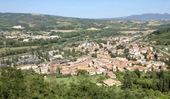

5 Case study: presentation 5 Umbria 2012, town of Orvieto
 Courtesy Francesco of Claudio Ballio")
6 Case study: presentation Rivers: Paglia and Chiani (confluence) Courtesy Francesco of Claudio Ballio Margottini, ISPRA
7 Introduction: the flood chain 7 atmosferic hydrological propagation along river flood damages

")

8 Introduction: the flood chain 8??? atmosferic rain: i(t) hydrological propagation along river flood damages
")

9 Introduction: the flood chain 9 atmosferic rain: i(t) discharge: Q(t) hydrological propagation along river flood damages
 hydrological propagation along river flood")
10 Introduction: the flood chain 10 atmosferic discharge: Q(t) water depth: h(t) hydrological propagation along river flood damages


11 Introduction: the flood chain 11 atmosferic hydrological water depth: h(t) propagation along river flood flooded area: A(t) damages

")
12 Introduction: the flood chain 12 atmosferic residential buildings hydrological propagation along river flood flooded area: A(t) damages

")
13 Introduction: the flood chain 13 commercial activities atmosferic hydrological agriculture propagation along river flood flooded area: A(t) damages
")
14 Introduction: the flood chain 14 atmosferic hydrological propagation along river flood infrastructures flooded area: A(t) damages
15 Introduction: the structure of risk 15 RISK = DAMAGE "+" PROBABILITY Damage = f ( x 1, x 2, x 3,, x N ) Hazard Exposure Vulnerability Probability variables x i may be considered / treated either as stochastic or deterministic How should we address this?
16 Introduction: the structure of risk RISK = DAMAGE "+" PROBABILITY Damage = f ( x 1, x 2, x 3,, x N ) For example: x 1 = rain quantity on a given day x 2 = river geometry 16 x 3 = residential value in a given area x i = x n = cars parked in a given area pdf pdf pdf pdf x 1 x 2 x 3 x n pdf D=0 Damage
17 Introduction: the structure of risk RISK = DAMAGE "+" PROBABILITY Damage = f ( x 1, x 2, x 3,, x N ) 17 Another example (bridge collapse): x 1 = flow depth and velocity x 2 = bridge geometry x 3 = resistance of materials x i = x n = traffic load pdf pdf pdf pdf x 1 x 2 x 3 x n pdf D=0 Damage
18 Introduction: the structure of risk 18 RISK = DAMAGE "+" PROBABILITY pdf Damage = f(threshold) pdf D=0 Damage Design: we basically consider only tails (to be avoided safety factors) Risk Assessment: we need the shape of the whole pdf D=0 Damage Safety factors are not of much help within risk assessment
19 Introduction: flood risk 19 Many s, models, parameters. Many steps, many uncertainties atmosferic Hazard Damage = f ( x 1, x 2, x 3,, x N ) Exposure Vulnerability causes effects hydrological propagation along river flood damages
20 Flood risk assessment: hazard 20 atmosferic Damage = f ( x 1, x 2, x 3,, x N ) river geometry town geometry vegetation bank and levee failures sediment transport origin / characteristics of uncertainties: natural system, complexity unsteadyness discharge: Q(t) hydrological propagation (1D) flood (2D) flooded area water depth damages water velocity contaminants
21 Flood risk assessment: hazard 21 atmosferic discharge: Q(t) hydrological propagation (1D) We consider our models to be relatively robust from the conceptual and mathematical perspectives. BUT: Available maps mostly come from 1D stationary calculations All inputs but discharge are treated as deterministic variables (often considered as null!) Uncertainties more or less subjectively embedded in safety factors. flood (2D) flooded area water depth damages water velocity contaminants

22 Case study: hazard Courtesy Francesco of Claudio Ballio Margottini, ISPRA

23 Case study: hazard 23 event discharge as for an estimated return period T=100 years


24 Case study: hazard Study mandated by the Orvieto Municipality to the professional consultant BETA Studio from Padova. Source: BETA Studio srl, S. Nicolò, PD, Analisi idraulica e idrologica della piena del fiume Paglia nelle zone di Orvieto Scalo e Ciconia e scenario di esondabilità: implicazioni per il sistema delle infrastrutture Francesco e Ballio dei trasporti, Ottobre 2013.
 neglected / simplified parameters and (sediment transport) but: ex-post!")

25 Reasons for discrepancies: singularities (1D vs.2d modelling) neglected / simplified parameters and (sediment transport) but: ex-post! Study mandated by the Orvieto Municipality to the professional consultant BETA Studio from Padova. Source: BETA Studio srl, S. Nicolò, PD, Analisi idraulica e idrologica della piena del fiume Paglia nelle zone di Orvieto Scalo e Ciconia e scenario di esondabilità: implicazioni per il sistema delle infrastrutture Francesco e Ballio dei trasporti, Ottobre 2013.
26 Flood risk assessment: exposure + vulnerability damages 26 atmosferic exposure: what is inside the affected area? vulnerability: how much of it will be damaged? hydrological Damage = f ( x 1, x 2, x 3,, x N ) Exposure Vulnerability physical damage value effects propagation (1D) flood (2D) damages
27 Flood risk assessment: exposure + vulnerability damages 27 flood (2D) flooded area water depth water velocity contaminants damage models residential buildings industrial & commercial activities agriculture sector infrastructures system parameters public items emergency costs people no more chain, cluster hazard (in)dependent? environmental and cultural herit.
28 Flooded area Calculation of DTM Flood risk assessment: exposure + vulnerability innundation depth (h) flooded area water depth water velocity contaminants system parameters flood (2D) PoliMi procedure Flood-IMPAT Integrated Meso-scale Procedure to Assess Territorial flood risk Flood profile CORINNE map Census block map Cultural/Env. heritage map Hazardous installations map Lifelines and strategic /pubblic facilities map Exposure map (spatial damage models distribution of high residential buildings Market value Building areas Net capital stock Production units EXPOSURE/VULNERABILITY Conversion table Overlapping/Intersection VULNERABILITY MAP (spatial distribution of land use classes) Monetary value estimation - settlements Monetary value estimationindustry agriculture Monetary value sector Net capital stock Monetary value Production estimation- monetary value) industrial units & commercial activities industry estimationwild areas Monetary value estimationhigh vulnerable infrastructures areas Population public items density vulnerable elements) Estimate of population at risk Monetary value emergency estimation- costs roads/railways HAZARD EXPOSURE MAP (spatial distribution of RISK FLOOD HAZARD MAP (spatial distribution of h) Monetary value (struct. & cont.) Monetary value (struct. & cont.) Monetary value (struct. & cont.) Damage curvessettlements Damage curvesindustry Damage curvesagriculture Direct tangible damage FLOOD HAZARD MAP (spatial distribution of h) Damage (struct. & cont.) Damage (struct. & cont.) Damage (struct. & cont.) FLOOD HAZARD MAP (spatial distribution of h) People at risk 28 Damage model (v=1) Indirect tangible damage Intangible damage FLOOD HAZARD MAP (spatial distribution of h).. Affected people people Monetary value estimationother lifelines Monetary value estimationpubblic/strategic facilities Monetary value estimationcultural/environmental and cultural H. goods Monetary value estimationhazardous installation Significance Combination TOTAL DAMAGE map.
29 Case study: damages 29 agriculture highway houses cars (parking) industries railway (station)
 Value of contents: 7.5% 25.")
30 Flood risk assessment: damages - buildings 30 Location and dimension of buildings from Cadastre Value of building structure from Real Estate and Property Price Database (OMI) Value of contents: 7.5% 25.5% of the reference market value of building structures (low-cost buildings luxury buildings)
31 Flood risk assessment: damages - buildings 31 Indicator Description a) Location Hazard level depends on building location b) Type of use Contents value (and, consequently, damage) depends on buildings use (e.g. residential, commercial, public service, etc.) c) Level of maintenance Well maintained buildings better face the impacts of floods than crumbling d) Age Age is usually linked to the level of maintenance e) Materials Some materials (like concrete and masonry) are more resistant to the flood impacts than others (e.g. timber, plasterboard, etc.) f) Number of storeys The presence of more than one storey allows people to move contents to upper floors g) Presence of basement h) Number of openings at street level i) Height from street level l) Presence of vulnerable equipments Basements can be flooded also in case of minor events (small water depth) Openings at street level make water to easily enter the building If ground floor is higher than street level water is hindered to enter the building If vulnerable equipments are present in more flood prone floors than damage can be higher
32 Case study: damages - buildings 32 1,2 1,0 Standard Method (Ministerie van Verkeer en Waterstaat, Holland) DAMAGE [-] 0,8 0,6 0,4 0,2 low rise intermediate high rise M Observed damage 0.56 Estimated_SM 0.84 Estimated_FLEMO_ps , WATER DEPTH [m] 0,90 FLEMO_ps (Thieken et al., 2008) DAMAGE [-] 0,75 0,60 0,45 one family detached multifamily umbria data 0,30 0,15 0,00 0 0,5 1 1,5 2 2,5 3 WATER DEPTH [m]
33 Case study: damages - buildings 33 DAMAGE [-] 1,2 1,0 0,8 0,6 0,4 0,2 0,0 Standard Method (Ministerie van Verkeer en Waterstaat, Holland) low rise intermediate high rise WATER DEPTH [m] to be discussed: M "richness" Observed of the model: damage how many parameters 0.56 it considers Estimated_SM 0.84 scale: object, areal (averaged) Estimated_FLEMO_ps 0.42 uncertainties (referred to scale) 0,90 FLEMO_ps (Thieken et al., 2008) damage % h Unresolved features are embedded in the pdf. Calibration needed! DAMAGE [-] 0,75 0,60 0,45 0,30 0,15 0,00 one family detached multifamily umbria data 0 0,5 1 1,5 2 2,5 3 WATER DEPTH [m]
34 Flood risk assessment: damages industrial activities 34 Rhein atlas (International commission for the protection of the Rhine) structure content
.")
35 Case study: damages industrial activities 35 The monetary value of industry land use class is calculated from the knowledge of (i) the net capital stock per production unit and (ii) the number of production units per census block, both supplied by ISTAT (subdivided by structures and contents). The net capital stock is differently calculated (at national level) for the several classes of industrial activities as defined by ATECO. Estimated damages Observed damages Damage to Businesses [M ] 26,5 28,6
36 Case study: damages, overall results 36 2% Umbria 2012, whole region 42% 11% 19% 23% 2% First aid Cultural Heritage Infrastructure Industry Agricolture Residential
37 Flood risk assessment: what for? (discussion) 37 There is no universal / general structure for (flood) risk assessment. Models, i.e.: their structure their scale their comprehesiveness their statistic vs. deterministic balance their accuracy (calibration / validation on data!) their can differ significantly from each other depending on the purpouse of the assessment. (what for?) back to the first slide
38 Risk assessment: what for? land use planning (say, construction permission) design mitigation works (river training) emergency management (contingency plans) insurance costs cost - benefit analysis Conclusions complexity of the problem lack of knowledge on the damage side role of uncertainty / stochastic variables the risk of (over)simplification no ONE solution (what for?)
Flood damage data gathering: procedures and use
 Flood damage data gathering: procedures and use Daniela Molinari 1, Giuseppe Aronica 2, Francesco Ballio 1, Nicola Berni 3, Claudia Pandolfo 3 1 Politecnico di Milano 2 Università di Messina 3 CFD Regione
Flood risk analysis and assessment: Case Study Gleisdorf
 Flood risk analysis and assessment: Case Study Gleisdorf H.P. Nachtnebel River room agenda Alpenraum 1 Integrated Flood Risk Managament Risk Assessment Increase of Resistance Reduction of Losses Prepardness
Appraising, prioritising and financing flood protection projects in Austria: Introduction of new Guidelines and Tools for Cost Benefit Analysis (CBA)
") Appraising, prioritising and financing flood protection projects in Austria: Introduction of new Guidelines and Tools for Cost Benefit Analysis (CBA) Heinz Stiefelmeyer 1, Peter Hanisch 2, Michael Kremser
Appraising, prioritising and financing flood protection projects in Austria: Introduction of new Guidelines and Tools for Cost Benefit Analysis (CBA) Heinz Stiefelmeyer 1, Peter Hanisch 2, Michael Kremser
Emergency Management. December 16, 2010
 Applications of Hazus-MH for Emergency Management December 16, 2010 What is Hazus-MH? Free ArcGIS extension Facilitates a risk-based approach to mitigation Identifies and visually displays hazards and
Ex post damage assessment: an Italian experience
 doi:10.5194/nhess-14-901-2014 Author(s) 2014. CC Attribution 3.0 License. Natural Hazards and Earth System Sciences Open Access Ex post damage assessment: an Italian experience D. Molinari 1, S. Menoni
EDIM. ADAPT and CCI-HYDR Workshop Liege, 10. January 2008
 EDIM ADAPT and CCI-HYDR Workshop Liege, 10. January 2008 THW MEDIS Overview and Interim Results Improved methods for the estimation and mapping of flood risks Annegret Thieken, Heidi Kreibich, Bruno Merz,
Regulations Regarding Preliminary Flood Risk Assessment, Flood Maps and Flood Risk Management Plan
 Text consolidated by Valsts valodas centrs (State Language Centre) with amending regulations of: 20 March 2012 [shall come into force from 23 March 2012]. If a whole or part of a paragraph has been amended,
2015 International Workshop on Typhoon and Flood- APEC Experience Sharing on Hazardous Weather Events and Risk Management.
 2015/05/27 Taipei Outlines The typhoon/flood disasters in Taiwan Typhoon/flood insurance in Taiwan Introduction of Catastrophe risk model (CAT Model) Ratemaking- Using CAT Model Conclusions 1 The Statistic
The AIR Inland Flood Model for Great Britian
 The AIR Inland Flood Model for Great Britian The year 212 was the UK s second wettest since recordkeeping began only 6.6 mm shy of the record set in 2. In 27, the UK experienced its wettest summer, which
Integrating Hazus into the Flood Risk Assessment
 Integrating Hazus into the Flood Risk Assessment GAFM Conference, March 22, 2016 Mapping Assessment Planning Agenda What is Hazus & Risk Assessment? Census Block vs. Site Specific Analysis User Defined
A model for estimating flood damage in Italy: preliminary results
 Environmental Economics and Investment Assessment 65 A model for estimating flood damage in Italy: preliminary results F. Luino, M. Chiarle, G. Nigrelli, A. Agangi, M. Biddoccu, C. G. Cirio & W. Giulietto
Government Decree on Flood Risk Management 659/2010
 Ministry of Agriculture and Forestry, Finland NB: Unofficial translation; legally binding texts are those in Finnish and Swedish. Government Decree on Flood Risk Management 659/2010 Section 1 Preliminary
BGC Project Memorandum
 Suite 500-1045 Howe Street, Vancouver, British Columbia, Canada. V6Z 2A9 Telephone (604) 684-5900 Fax (604) 684-5909 BGC Project Memorandum To: Attention: CANHUG Meeting Participants From: Kris Holm, BGC
Comparison of different approaches for flood damage and risk assessment
 Perception of uncertainty in water management by stakeholders and researchers Prague, 14-16 May 2007 NeWater Project Comparison of different approaches for flood damage and risk assessment Annegret H.
Non Regulatory Risk MAP Products Flood Depth and Probability Grids
 Non Regulatory Risk MAP Products Flood Depth and Probability Grids Virginia Floodplain Management Association 2015 Floodplain Management Workshop October 29th, 2015 Nabil Ghalayini, P.E., PMP, D.WRE, CFM
Leveraging HAZUS for Risk Assessment Analysis within Risk MAP
 Leveraging HAZUS for Risk Assessment Analysis within Risk MAP Jen Meyer - FEMA Region X Shane Parson - RAMPP PTS Team (URS Corp.) 2010 HAZUS Conference - August 2010 The Paradigm Shift: Map Mod to Risk
DEFINING BEST PRACTICE IN FLOODPLAIN MANAGEMENT
 DEFINING BEST PRACTICE IN FLOODPLAIN MANAGEMENT M Babister 1 M Retallick 1 1 WMAwater, Level 2,160 Clarence Street Sydney Abstract With the upcoming release of the national best practice manual, Managing
OECD Review on the Seine Flood Risk In Paris area. Economic impacts
 OECD Review on the Seine Flood Risk In Paris area Economic impacts Seine Floods in Paris What would be the impact of a major flood in Paris? Cascading effects through the interruption of critical networks
C o p e r n i c u s E m e r g e n c y M a n a g e m e n t S e r v i c e f o r R i s k p l a n n i n g a n d R e c o v e r y
 C o p e r n i c u s E m e r g e n c y M a n a g e m e n t S e r v i c e f o r R i s k p l a n n i n g a n d R e c o v e r y Copernicus Service Copernicus EU Copernicus EU Copernicus EU www.copernicus.eu
Town of Montrose Annex
 Town of Montrose Annex Community Profile The Town of Montrose is located in the Southwest quadrant of the County, east of the Town of Primrose, south of the Town of Verona, and west of the Town of Oregon.
FREQUENTLY ASKED QUESTION ABOUT FLOODPLAINS Michigan Department of Environmental Quality
 FREQUENTLY ASKED QUESTION ABOUT FLOODPLAINS Michigan Department of Environmental Quality WHAT IS A FLOOD? The National Flood Insurance Program defines a flood as a general and temporary condition of partial
FLOOD HAZARD AND RISK MANAGEMENT UTILIZING HYDRAULIC MODELING AND GIS TECHNOLOGIES IN URBAN ENVIRONMENT
 Proceedings of the 14 th International Conference on Environmental Science and Technology Rhodes, Greece, 3-5 September 2015 FLOOD HAZARD AND RISK MANAGEMENT UTILIZING HYDRAULIC MODELING AND GIS TECHNOLOGIES
Environment Agency pre-application advice incorporating Local Flood Risk Standing Advice from East Lindsey District Council
 Environment Agency pre-application advice incorporating Local Flood Risk Standing Advice from East Lindsey District Council Version 1 UNCLASSIFIED We are the Environment Agency. We protect and improve
Damage assessment in the stress field of scale, comparability and transferability
 Damage assessment in the stress field of scale, comparability and transferability André Assmann 1,a and Stefan Jäger 1 1 geomer GmbH, Im Breitspiel 11B, 69126 Heidelberg, Germany Abstract. Damage assessment
Flood impact Urban area. Include climate change scenarios; Flood extent & Rijnmond-Drechtsteden region; depth. Apply a high level of detail;
 William Veerbeek FLOOD RESILIENCE GROUP WE Department Unesco-IHE Westvest 7 P.O. Box 315 261DA Delft Netherlands T: +31()15 2151 821 M: +31()6 427 88 359 w.veerbeek@floodresiliencegroup.org www.floodresiliencegroup.org
Skagit County Flood Insurance Study Update. Ryan Ike, CFM FEMA Region 10
 Skagit County Flood Insurance Study Update Ryan Ike, CFM FEMA Region 10 Skagit County Flood Insurance Study Process Overview Process, Schedule, & Deliverables Base Flood Elevations, Modeling, & Levees
The AIR Inland Flood Model for the United States
 The AIR Inland Flood Model for the United States In Spring 2011, heavy rainfall and snowmelt produced massive flooding along the Mississippi River, inundating huge swaths of land across seven states. As
Flood preparedness of private households and small businesses in the Mekong Delta, Vietnam
 Flood preparedness of private households and small businesses in the Mekong Delta, Vietnam Heidi Kreibich, Philip Bubeck, Chinh Do Section Hydrology, German Research Centre for Geosciences (GFZ) Introduction
Risk Analysis of Bridges to Prioritize Post-Storm Scour Mitigation Plans
 Risk Analysis of Bridges to Prioritize Post-Storm Scour Mitigation Plans Samaneh GHOLITABAR Elham AZIMI Fletcher H. GRIFFIS May 31- June 2, 2016 Outline Introduction Objectives Methodology Conclusion Introduction
BACKGROUND When looking at hazard and loss data for future climate projections, hardly any solid information is available.
 BACKGROUND Flooding in Europe is a peak peril that has the potential to cause losses of over 14 billion in a single event. Most major towns and cities are situated next to large rivers with large amounts
National Disaster Mitigation Program NDMP Overview, Ontario Projects, and Final Call for Proposals
 National Disaster Mitigation Program NDMP Overview, Ontario Projects, and Final Call for Proposals March 6, 2018 NDMP Overview The NDMP is a 5-year federal program that set out $183 million for flood mitigation
MODEL VULNERABILITY Author: Mohammad Zolfaghari CatRisk Solutions
 BACKGROUND A catastrophe hazard module provides probabilistic distribution of hazard intensity measure (IM) for each location. Buildings exposed to catastrophe hazards behave differently based on their
Upper Joachim Creek Public Survey on Potential Flood Risk Reduction
 Upper Joachim Creek Public Survey on Potential Flood Risk Reduction This survey is intended to help the interagency planning committee to receive public feedback on specific flood risk reduction techniques,
Working Paper Regional Expert Group Meeting on Capacity Development for Disaster Information Management
 Working Paper Regional Expert Group Meeting on Capacity Development for Disaster Information Management A Proposal for Asia Pacific Integrated Disaster Risk Information Platform Prof. Mohsen Ghafouri-Ashtiani,
A brief introduction to the Flood (Risk) Directive. Jan Verkade, M.A. Delft Hydraulics
 Directive. Jan Verkade, M.A. Delft Hydraulics") A brief introduction to the Flood (Risk) Directive Jan Verkade, M.A. Delft Hydraulics Flood Risk Directive s full name: Directive 2007/60/EC of the European Parliament and of the Council on the assessment
A brief introduction to the Flood (Risk) Directive Jan Verkade, M.A. Delft Hydraulics Flood Risk Directive s full name: Directive 2007/60/EC of the European Parliament and of the Council on the assessment
Flood Risk. How do we manage flood risks? Built Form. Components of Flood Risk. Consequence of a flood. Chance of a flood
 Built Form Managing flood risk can be delivered through both planning scheme and non-planning scheme measures. During Summer 2010/2011 we witnessed just how well our built form performed. It was evident
Turriff (Potentially Vulnerable Area 06/07) Local Plan District Local authority Main catchment North East Aberdeenshire Council River Deveron Backgrou
 Local Plan District Local authority Main catchment North East Aberdeenshire Council River Deveron Backgrou") Turriff (Potentially Vulnerable Area 06/07) Local Plan District North East Local authority Aberdeenshire Council Main catchment River Deveron Summary of flooding impacts At risk of flooding
Turriff (Potentially Vulnerable Area 06/07) Local Plan District North East Local authority Aberdeenshire Council Main catchment River Deveron Summary of flooding impacts At risk of flooding
Flood Damage Assessment (Case study: Sirajganj District)
") Flood Damage Assessment (Case study: Sirajganj District) Photo Courtesy: Climate and Capitalism Photo Courtesy: Practical Action Blog A.K.M. Saiful Islam Professor Institute of Water and Flood Management
Flood Damage Assessment (Case study: Sirajganj District) Photo Courtesy: Climate and Capitalism Photo Courtesy: Practical Action Blog A.K.M. Saiful Islam Professor Institute of Water and Flood Management
Mapping flood risk its role in improving flood resilience in England
 Mapping flood risk its role in improving flood resilience in England Catherine Wright Director of Digital and Skills Flood and Coastal Risk Management Environment Agency 6 October 2017 The Environment
Inverurie and Kintore (Potentially Vulnerable Area 06/13) Local Plan District Local authority Main catchment North East Aberdeenshire Council River Do
 Local Plan District Local authority Main catchment North East Aberdeenshire Council River Do") Inverurie and Kintore (Potentially Vulnerable Area 06/13) Local Plan District North East Local authority Aberdeenshire Council Main catchment River Don Summary of flooding impacts 230 residential properties
Inverurie and Kintore (Potentially Vulnerable Area 06/13) Local Plan District North East Local authority Aberdeenshire Council Main catchment River Don Summary of flooding impacts 230 residential properties
Status of the implementation of FD 2007/60/EC in Austria and Styria
 OFFICE OF THE STYRIAN GOVERNMENT Department 14 Water Management, Resources and Sustainability Protective Water Management Unit Status of the implementation of FD 2007/60/EC in Austria and Styria Christoph
Conon Bridge and Muir of Ord (Potentially Vulnerable Area 01/16) Local authority Main catchment The Highland Council River Conon Background This Poten
 Local authority Main catchment The Highland Council River Conon Background This Poten") Conon Bridge and Muir of Ord (Potentially Vulnerable Area 01/16) Local authority The Highland Council Main catchment River Conon Summary of flooding impacts Summary of flooding impacts At risk of flooding
Conon Bridge and Muir of Ord (Potentially Vulnerable Area 01/16) Local authority The Highland Council Main catchment River Conon Summary of flooding impacts Summary of flooding impacts At risk of flooding
Overview of Capabilities and Current Limitations
 Overview of Capabilities and Current Limitations Overview of the National Flood Risk Characterization Tool (NFRCT) Map based viewer of relative flood risk around the U.S., with supporting reports for more
FLOOD RISK MANAGEMENT PLAN DEVELOPMENT IN ROMANIA. 10th Steering Group Meeting of PA5 (Management of Environmental Risks) SUERD 29 th February 2016
 SUERD 29 th February 2016") FLOOD RISK MANAGEMENT PLAN DEVELOPMENT IN ROMANIA 10th Steering Group Meeting of PA5 (Management of Environmental Risks) SUERD 29 th February 2016 STAGE FOR IMPLEMENTATION OF THE DIRECTIVE 2007/60/EC IN
FLOOD RISK MANAGEMENT PLAN DEVELOPMENT IN ROMANIA 10th Steering Group Meeting of PA5 (Management of Environmental Risks) SUERD 29 th February 2016 STAGE FOR IMPLEMENTATION OF THE DIRECTIVE 2007/60/EC IN
Planning and Flood Risk
 Planning and Flood Risk Patricia Calleary BE MEngSc MSc CEng MIEI After the Beast from the East Patricia Calleary Flood Risk and Planning Flooding in Ireland» Floods are a natural and inevitable part of
Canada s exposure to flood risk. Who is affected, where are they located, and what is at stake
 Canada s exposure to flood risk Who is affected, where are they located, and what is at stake Why a flood model for Canada? Catastrophic losses Insurance industry Federal government Average industry CAT
Financing Floods in Chicago. Sephra Thomas. GIS for Water Resources C E 394K. Dr. David Maidment
 Financing Floods in Chicago Sephra Thomas GIS for Water Resources C E 394K Dr. David Maidment Fall 2018 Abstract The objective of this term paper is to study the hydrology and social vulnerability of Chicago,
CONSISTENCY OF REPORTING PERFORMANCE MEASURES REPORTING GUIDANCE SEWER FLOODING
 CONSISTENCY OF REPORTING PERFORMANCE MEASURES REPORTING GUIDANCE SEWER FLOODING Report Ref. No. 17/RG/04/5 Reporting Guidance Sewer Flooding 1. Objective This guidance seeks to enable all companies to
Flood risk assessment for sustainable urban development : Case study of Marikina-Pasig-San Juan river basin, Manila
 International Conference in Urban and Regional Planning "Planning towards Sustainability and Resilience" 14 15 March, 2018 Manila, Philippines Flood risk assessment for sustainable urban development :
3D Elevation Program (3DEP) Status and Plans. Kevin T. Gallagher Associate Director, Core Science Systems June 26, 2017
 Status and Plans. Kevin T. Gallagher Associate Director, Core Science Systems June 26, 2017") + 3D Elevation Program (3DEP) Status and Plans Kevin T. Gallagher Associate Director, Core Science Systems June 26, 2017 + 2 3D Elevation Program (3DEP) Apply lidar technology to map bare earth and 3D
+ 3D Elevation Program (3DEP) Status and Plans Kevin T. Gallagher Associate Director, Core Science Systems June 26, 2017 + 2 3D Elevation Program (3DEP) Apply lidar technology to map bare earth and 3D
Impacts and Economic Costs of River Floods in the EU and Costs of Adaptation
 Impacts and Economic Costs of River Floods in the EU and Costs of Adaptation Luc Feyen Getty Images Joint Research Centre European Commission Water and Adaptation to Climate Change in Transboundary Basins:
Towards the inclusion of external factors in quantitative risk assessment: the analysis of NaTech accident scenarios
 Towards the inclusion of external factors in quantitative risk assessment: the analysis of NaTech accident scenarios Valerio Cozzani Dipartimento di Ingegneria Chimica, Mineraria e delle Tecnologie Ambientali
MANAGING FLOOD AND WATER-RELATED RISKS: A CHALLENGE FOR THE FUTURE
 MANAGING FLOOD AND WATER-RELATED RISKS: A CHALLENGE FOR THE FUTURE Tarek MERABTENE, Junichi YOSHITANI and Daisuke KURIBAYASHI Public Works Research Institute (PWRI), 1-6 Minamihara, 305-8516Tsukuba, Japan
Presentation Overview
 2006 Northwest Stream Restoration Design Symposium The National Evaluation of the One-Percent (100-Year) Flood Standard and Potential Implications on Stream Restoration Projects Kevin Coulton, P.E., CFM
Implementation of intelligence of flood disaster debris discharge for emergency response
 Risk Analysis VII PI-681 Implementation of intelligence of flood disaster debris discharge for emergency response N. Hirayama1, T. Shimaoka2, T. Fujiwara3, T. Okayama4 & Y. Kawata5 1 Department of Environmental
Flood Risk Assessment in the
 Georgia Flood M.A.P. Program Flood Risk Assessment in the Upper Chattahoochee h h River Basin GAFM Annual Conference March 28, 2012 Agenda Map Mod to Risk MAP (Georgia Flood M.A.P.) transition Flood Risk
Microsimulation of Land Use and Transport in Cities
 of Land Use and Transport in Cities Model levels Multi-level Michael Wegener City Multi-scale Advanced Modelling in Integrated Land-Use and Transport Systems (AMOLT) 1 M.Sc. Transportation Systems TU München,
Multi-Hazard Damage and Loss Estimates to Buildings and Lifelines. M. Capozzo, A. Rizzi, A. Barbosa, G.P. Cimellaro
 Multi-Hazard Damage and Loss Estimates to Buildings and Lifelines M. Capozzo, A. Rizzi, A. Barbosa, G.P. Cimellaro 1 Introduction In this research we examine and compare the vulnerabilities of a community
Nairn East and Auldearn (Potentially Vulnerable Area 05/08) Local Planning District Local authority Main catchment Findhorn, Nairn and Speyside The Hi
 Local Planning District Local authority Main catchment Findhorn, Nairn and Speyside The Hi") Nairn East and Auldearn (Potentially Vulnerable Area 05/08) Findhorn, Nairn and Speyside Local authority The Highland Council Main catchment River Nairn Summary of flooding impacts Summary of flooding
Nairn East and Auldearn (Potentially Vulnerable Area 05/08) Findhorn, Nairn and Speyside Local authority The Highland Council Main catchment River Nairn Summary of flooding impacts Summary of flooding
DES MOINES CITY OF TWO RIVERS. Flooding Risk & Impact to Development
 DES MOINES CITY OF TWO RIVERS Flooding Risk & Impact to Development River System Des Moines Flood Protection Des Moines Flood Protection cont. Infrastructure Over 24 miles of levees 21stormwater pump stations
Analysis of costs & benefits of risk reduction strategies
 Analysis of costs & benefits of risk reduction strategies adapted by Emile Dopheide from RiskCity Exercise 7b, by Cees van Westen and Nanette Kingma ITC January 2010 1. Introduction The municipality of
RISK ASSESSMENT IN TRANSBOUNDARY COOPERATION BETWEEN THE NETHERLANDS AND GERMANY
 4 th International Symposium on Flood Defence: Managing Flood Risk, Reliability and Vulnerability Toronto, Ontario, Canada, May 6-8, 2008 RISK ASSESSMENT IN TRANSBOUNDARY COOPERATION BETWEEN THE NETHERLANDS
Dealing With Unnumbered A Zones in Maine Floodplain Management
 Dealing With Unnumbered A Zones in Maine Floodplain Management The following is a list of acceptable methods that the State Floodplain Management Coordinator and the Federal Emergency Management Agency
Damages caused by Flash Floods
 Damages caused by Flash Floods Damages caused as a result of flash flood are enormous both on human lives and loss of property. It is reported that flood disasters account for about a third of all natural
Development Fee Program: Comparative risk analysis
 Development Fee Program: Comparative risk analysis January 2008 Sacramento Area Flood Control Agency David Ford Consulting Engineers, Inc. 2015 J Street, Suite 200 Sacramento, CA 95811 Ph. 916.447.8779
Flooding Part One: BE Informed. Department of Planning & Development
 Flooding Part One: BE Informed Department of Planning & Development Introduction The residents of the City of Noblesville enjoy many benefits from being located on the banks of the White River. These benefits
The AIR Coastal Flood Model for Great Britain
 The AIR Coastal Flood Model for Great Britain The North Sea Flood of 1953 inundated more than 100,000 hectares in eastern England. More than 24,000 properties were damaged, and 307 people lost their lives.
THE EU FLOODS DIRECTIVE:
 Sixth Bulgarian Austrian Seminar THE EU FLOODS DIRECTIVE: EUROPEAN PRACTICE AND RESEARCH IN FLOOD RISK MANAGEMENT Mark Adamson Co-Chair, Working Group F Office of Public Works, IE 7 th November, 2013 PRESENTATION
Coastal Flood Hazard and Risk Maps in Denmark. Thorsten Piontkowitz & Laura Storm Henriksen, Danish Coastal Authority
 Coastal Flood Hazard and Risk Maps in Denmark Thorsten Piontkowitz & Laura Storm Henriksen, Danish Coastal Authority Contents Introduction Denmark and the coastal zone Identified flood prone areas Flood
Flood Risk and Safety in the Netherlands (FLORIS) the method
 the method") Flood Risk and Safety in the Netherlands (FLORIS) the method Tsukuba, October 1 st 2009 Durk Riedstra Rijkswaterstaat, Centre for Water Management Presentation Introduction Current protection standards
Flood Risk and Safety in the Netherlands (FLORIS) the method Tsukuba, October 1 st 2009 Durk Riedstra Rijkswaterstaat, Centre for Water Management Presentation Introduction Current protection standards
Requirements for Mapping Levees Complying with Section of the NFIP Regulations
 FACT SHEET Requirements for Mapping Levees Complying with Section 65.10 of the NFIP Regulations As part of a mapping project, it is the levee owner s or community s responsibility to provide data and documentation
Creetown (Potentially Vulnerable Area 14/17) Local Plan District Local authority Main catchment Dumfries and Galloway Solway Moneypool Burn Council Ba
 Local Plan District Local authority Main catchment Dumfries and Galloway Solway Moneypool Burn Council Ba") Creetown (Potentially Vulnerable Area 14/17) Local Plan District Solway Local authority Dumfries and Galloway Council Main catchment Moneypool Burn Summary of flooding impacts 90 residential properties
Creetown (Potentially Vulnerable Area 14/17) Local Plan District Solway Local authority Dumfries and Galloway Council Main catchment Moneypool Burn Summary of flooding impacts 90 residential properties
REQUEST FOR PROPOSALS. Planning in Water s Way: Flood Resilient Economic Development Strategy for the I-86 Innovation Corridor
 REQUEST FOR PROPOSALS Planning in Water s Way: Flood Resilient Economic Development Strategy for the I-86 Innovation Corridor Southern Tier Central Regional Planning and Development Board (STC) is seeking
Flood risk assessment and management in Slovakia
 River Basin Management VI 61 Flood risk assessment and management in Slovakia M. Zeleňáková Institute of Building and Environmental Engineering, Technical University of Košice, Slovakia Abstract In recent
Ellon (Potentially Vulnerable Area 06/12) Local Plan District North East Local authority Aberdeenshire Council Main catchment River Ythan, Buchan coas
 Local Plan District North East Local authority Aberdeenshire Council Main catchment River Ythan, Buchan coas") Ellon (Potentially Vulnerable Area 06/12) Local Plan District North East Local authority Aberdeenshire Council Main catchment River Ythan, Buchan coastal Summary of flooding impacts 110 residential 40
Ellon (Potentially Vulnerable Area 06/12) Local Plan District North East Local authority Aberdeenshire Council Main catchment River Ythan, Buchan coastal Summary of flooding impacts 110 residential 40
Tool 3.3: Case study example of risk assessment using RiskScape
 Impacts of Climate Change on Urban Infrastructure & the Built Environment A Toolbox Tool 3.3: Case study example of risk assessment using RiskScape Author S. Reese Affiliation NIWA, Private Bag 14901,
Risk Assessment for Floods Due to Precipitation Exceeding Drainage Capacity
 Risk Assessment for Floods Due to Precipitation Exceeding Drainage Capacity November 2006 Umut Karamahmut Faculty of Civil Engineering and Geosciences i i. Abstract Studies on flood risk modeling were
Gallinas Watershed Program
 C O M M U N I T Y M E E T I N G April 5, 2016 Tonight s Agenda S C H E D U L E O F P R E S E N T A T I O N S Presentation: Gallinas Watershed Program Overview Questions and Answers Presentation: Upper
BUTTS COUNTY, GEORGIA AND INCORPORATED AREAS
 BUTTS COUNTY, GEORGIA AND INCORPORATED AREAS Butts County Community Name Community Number BUTTS COUNTY (UNICORPORATED AREAS) 130518 FLOVILLA, CITY OF 130283 JACKSON, CITY OF 130222 JENKINSBURG, TOWN OF
SECTION 6. FLOODPLAIN MANAGEMENT DISTRICT
 SECTION 6. FLOODPLAIN MANAGEMENT DISTRICT Subsection 6.1: Statutory Authorization, Findings of Fact & Purpose A. Statutory Authorization: The legislature of the State of Minnesota has, in Minnesota Statues
Chapter 5 Floodplain Management
 Chapter 5 Floodplain Management Contents 1.0 Introduction... 1 2.0 Floodplain Management and Regulation... 1 2.1 City Code... 1 2.2 Floodplain Management... 1 2.3 Level of Flood Protection... 2 2.3.1 Standard
Flood Hazards & Infrastructure Risk in the Lower Mainland Towards a Regional Strategy for Risk Reduction
 Flood Hazards & Infrastructure Risk in the Lower Mainland Towards a Regional Strategy for Risk Reduction Fraser Basin Council Infrastructure Sector Workshop November 5, 2018 Lower Mainland Flood Management
Final report: Quantitative Risk Assessment models and application to the Eindhoven case study
 Final report: Quantitative Risk Assessment models and application to the Eindhoven case study Final report: Quantitative Risk Assessment models and application to the Eindhoven case study 2010 PREPARED
Background to the PFRA European Overview UC10508
 Background to the PFRA European Overview UC10508 The individual Member State Reports reflect the situation as reported by the Member States to the European Commission in 2014 The situation in the MSs may
The approach to managing natural hazards in this Plan is to: set out a clear regional framework for natural hazard management
 10 Natural Hazards 10.1 Scope and Background This chapter establishes an overall framework for natural hazard management under the Resource Management Act 1991 (RMA). It also sets out the division of responsibilities
Second workshop on Transboundary Flood Risk Management, Geneva, March 2015
 Second workshop on Transboundary Flood Risk Management, Geneva, 19-20 March 2015 PILOT CASE STUDY OF THE PRELIMINARY FLOOD RISK ASSESSMENT, MAPPING AND INVENTORY OF THE FLOOD RISK MANAGEMENT PLANNING FOR
Bucks County, PA Flood Risk Review Meeting. November 2014
 Bucks County, PA Flood Risk Review Meeting November 2014 Agenda for Today Risk MAP Program overview Overview of non-regulatory Flood Risk Products and datasets Discuss mitigation action Technical overview
Earthquake and Flood Disaster Management Regulations in Turkey
 DISASTER SCIENCE AND ENGINEERING p. 1-6, 2(1), 2016 Earthquake and Flood Disaster Management Regulations in Turkey Esra Dobrucali 1, Ismail Hakki Demir 2 Received: 04.04.2016 Accepted: 13.04.2016 Abstract:
The new European Flood Management Directive and the municipal flood management system as one realization approach
 The new European Flood Management Directive and the municipal flood management system as one realization approach, Manuela Gretzschel University of Kaiserslautern, Germany Prof. Dr. Volker Lüderitz Magdeburg
Talk Components. Wharton Risk Center & Research Context TC Flood Research Approach Freshwater Flood Main Results
 Dr. Jeffrey Czajkowski (jczaj@wharton.upenn.edu) Willis Research Network Autumn Seminar November 1, 2017 Talk Components Wharton Risk Center & Research Context TC Flood Research Approach Freshwater Flood
EUROPEAN DIRECTIVE FLOODS 2007/60/EC AND RIVER BASIN PLANNING
 EUROPEAN DIRECTIVE FLOODS 2007/60/EC AND RIVER BASIN PLANNING Fare clic per modificare lo stile del sottotitolo dello schema Ing. Giorgio Cesari General Secretary of Tevere river basin Authority TEVERE
ASFPM Partnerships for Statewide Mitigation Actions. Alicia Williams GIS and HMP Section Manager, Amec Foster Wheeler June 2016
 ASFPM Partnerships for Statewide Mitigation Actions Alicia Williams GIS and HMP Section Manager, Amec Foster Wheeler June 2016 Summary The Concept Leveraging Existing Data and Partnerships to reduce risk
Dunblane and Bridge of Allan (Potentially Vulnerable Area 09/03) Local Plan District Local authority Main catchment Forth Stirling Council Allan Water
 Local Plan District Local authority Main catchment Forth Stirling Council Allan Water") Dunblane and Bridge of Allan (Potentially Vulnerable Area 09/03) Local Plan District Forth Local authority Stirling Council Main catchment Allan Water Summary of flooding impacts At risk of flooding 370
Dunblane and Bridge of Allan (Potentially Vulnerable Area 09/03) Local Plan District Forth Local authority Stirling Council Main catchment Allan Water Summary of flooding impacts At risk of flooding 370
Chapter 6 - Floodplains
 Chapter 6 - Floodplains 6.1 Overview The goal of floodplain management is to reduce the potential risks to both existing and future developments, and infrastructure, in the 100-year floodplain. Over the
RiskTopics. Guide to flood emergency response plans September 2017
 RiskTopics Guide to flood emergency response plans September 2017 While floods are a leading cause of property loss, a business owner can take actions to mitigate and even help prevent damage and costly
Flood damage analysis and development of flood damage models for the Mekong delta
 Flood damage analysis and development of flood damage models for the Mekong delta Thi-Chinh Do, Heidi Kreibich GFZ German Research Centre for Geosciences Bonn, June 2013 Slide 1 Introduction Vietnam is
A Flood Mitigation Plan for the Non-Tidal N.J. Section of the Delaware River Basin. Warren County Planning Workshop (2 nd Meeting) March 7, 2007
 March 7, 2007") A Flood Mitigation Plan for the Non-Tidal N.J. Section of the Delaware River Basin Warren County Planning Workshop (2 nd Meeting) March 7, 2007 Study Area Participation: Hunterdon: 16 Eligible Municipalities
A Flood Mitigation Plan for the Non-Tidal N.J. Section of the Delaware River Basin Warren County Planning Workshop (2 nd Meeting) March 7, 2007 Study Area Participation: Hunterdon: 16 Eligible Municipalities
Flood Solutions. Summer 2018
 Flood Solutions Summer 2018 Flood Solutions g Summer 2018 Table of Contents Flood for Lending Life of Loan Flood Determination... 2 Multiple Structure Indicator... 2 Future Flood... 2 Natural Hazard Risk...
Flood Depth-Damage Functions for Built Environment
 Environ. Process. (2014) 1:553 572 DOI 10.1007/s40710-014-0038-2 ORIGINAL ARTICLE Flood Depth-Damage Functions for Built Environment Aimilia Pistrika & George Tsakiris & Ioannis Nalbantis Received: 27
Risk of Flooding from Rivers and Sea
 Risk of Flooding from Rivers and Sea Product Description April 2015 RISK OF FLOODING FROM RIVERS AND SEA PRODUCT DESCRIPTION An assessment of flood risk for England produced using local data and expertise.