EDIM. ADAPT and CCI-HYDR Workshop Liege, 10. January 2008
|
|
|
- Scot Hines
- 5 years ago
- Views:
Transcription


1 EDIM ADAPT and CCI-HYDR Workshop Liege, 10. January 2008 THW MEDIS Overview and Interim Results Improved methods for the estimation and mapping of flood risks Annegret Thieken, Heidi Kreibich, Bruno Merz, Klaus Piroth
2 EDIM Dr. Klaus Piroth Civil Engineer University Karlsruhe PhD in Hydraulic Engineering (Prof. Plate) THW Since 1995 with ARCADIS.DE Head of segment: Water Management


3 MEDIS: Methods for the Evaluation of Direct and Indirect flood losses R. Schwarze U. Kunert A. Thieken, I. Seifert, F. Elmer, H. Kreibich, B. Merz J. Schwarz H. Maiwald A. Gerstberger B. Kuhlmann B. Weinmann K. Piroth V. Ackermann LTV U. Müller (S. Kobsch) M. Müller Umweltamt J. Seifert ADAPT and CCI-HYDR Workshop Liege, 10. January 2008

4 Quantitative Risk Analysis Hazard Vulnerability Risk exceedence probability Three important questions: What can go wrong? How likely is it that it will happen? If it does happen, what are the consequences? Sources: Merz & Thieken (2004) ÖWAW 56 (3-4): 27-34; Kaplan & Garrick (1981) Risk Analysis 1(1).


5 Improved methods for the estimation and mapping of flood risks Model development for different sectors: Example New Model for the estimation of losses in private households - Model validation for different flood situations - Knowledge transfer by case studies and guidelines
6 Flood losses and influence factors

 damage model")

7 Flood risk estimation: Input data Inundation scenarios and probabilities Land use and assets (relative) damage model Example: damage to residential buildings Damage estimates / Risk curve
 Source: Merz et al. (2004) - NHESS, 4(1): 153-163.")
8 Flood damage data in Germany: HOWAS ( ) HOWAS: Data base of the Bavarian Agency of Water Resources 1735 damage records of private houses non-parametric regression (Epanechnikovkernel, bandwidth = 0.6 m) Source: Merz et al. (2004) - NHESS, 4(1):
 Source: Müller & Thieken (2005) - Versicherungswirtschaft 60(2):")
9 Survey of flood affected private households (August 2002) 1697 computer-aided telephone interviews in April and May questions: Damage to buildings/contents Flood characteristics Building characteristics Flood warning Private precaution Flood experience 30 minutes (average) Source: Müller & Thieken (2005) - Versicherungswirtschaft 60(2):


10 Influence of water level: median and interquartile range (IQR) Source: Thieken et al. (2005) WRR 41(12): W12430.


11 Flood damage augmentation by contamination 75%-Quantile Mean Median (50%-Quantile) 25%-Quantile Source: Thieken et al. (2005) WRR 41: W12430.
![Flood loss reduction by precautionary measures Examples: Loss ratio of a building [%] Building use adapted Interior decoration](/docs-images/81/83643459/images/12-0.jpg "adapted unadapted unadapted Electricity supply in upper floors in basement Source: Kreibich, Thieken et al.")
12 Flood loss reduction by precautionary measures Examples: Loss ratio of a building [%] Building use adapted Interior decoration adapted unadapted unadapted Electricity supply in upper floors in basement Source: Kreibich, Thieken et al. (2005) NHESS 5:


13 Flood losses and influence factors
14 Flood Loss Estimation MOdel FLEMO Loss ratio of a building [%] one-family house (semi-)detached multifamily house high building quality poor/average building quality Source: Büchele et al. (2006) NHESS 6: Modellstufe: Zu-/Abschläge < 21 cm cm cm cm > 150 cm Water level (above ground surface) Contamination FLEMO+ Private precaution none good very good none moderate severe


15 Scales in flood loss estimation Meso-scale estimation / data is based on land use units (e.g. CORINE land cover), provides no damage estimate per object, only per region. Micro-scale estimation / data is based on single objects/buildings, demands very detailed input data


16 Databases on assets EDIM Reconstruction costs of residential buildings, reference year 2000 Municipal per-capita value Capital stock per municipality 60 branches, 3 company sizes, 2 types Source: Kleist et al. (2006) NHESS


17 Scaling FLEMO from micro to meso-scale Calculation of a mean loss model per zip code or municipality Consideration of a typical composition of building types and building quality per zip code based on census data (INFAS Geodaten, 2001) Typical composition of building types Average building quality Source: Thieken et al. submitted to J. Hydrol.

18 Meso-scale stage-damage-functions Source: Thieken et al. submitted to J. Hydrol.
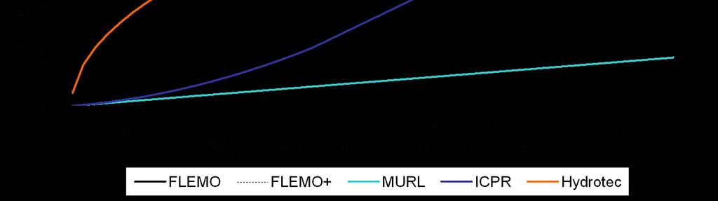
19 Model validation on the basis of actual repair costs: August 2002 flood in Saxony (13 municipalities) Estimated Building Loss [Mill. Euro] FLEMO+ 1:1 MURL (2000) 70 ICPR (2001) Source: Thieken et al. submitted to J. Hydrol. Reported Building Repair Costs at SAB [Mill. Euro]

20 Model application in large regions Example: Inundation at the River Rhine Scenario: Extreme flood event from the ICPR-Rhine atlas Damage to residential buildings per municipality
21 Work in progress Further model evaluations with a focus on transferability (further case studies are welcome!) Development of software tools for (rapid) damage estimation Adaptation of FLEMO to flood problems due to rising groundwater Filter criteria for the influence of flow velocity (yes no) Improving the loss estimation model for damage of companies Development of web-services for the assessment of a flood situation with respect to the danger to people and infrastructure Development of standardised methods for loss data collection and setup of the flood loss data base HOWAS 21
22 Summary and conclusions Many empirical data about flood losses have been gathered after the severe flood in August 2002 in the Elbe and the Danube catchment. The new flood loss estimation model FLEMO+ not only considers water level and building use/type, but also building quality, contamination and precaution. A transparent scaling procedure for applications on the meso-scale was developed. Model validation reveals that FLEMO+ outperforms stage-damagefunctions and therefore improves results of risk analyses. Future challenges include the inclusion of further damage types, the adaptation of the model to other flood types (coastal floods, flash floods) and the transfer to other countries.
Comparison of different approaches for flood damage and risk assessment
 Perception of uncertainty in water management by stakeholders and researchers Prague, 14-16 May 2007 NeWater Project Comparison of different approaches for flood damage and risk assessment Annegret H.
Flood Damage Assessment Literature review and recommended procedure. Lea Olesen, Roland Löwe, and Karsten Arnbjerg-Nielsen
 Flood Damage Assessment Literature review and recommended procedure Lea Olesen, Roland Löwe, and Karsten Arnbjerg-Nielsen 2 Flood damage assessment Flood Damage Assessment Literature review and recommended
Damage assessment in the stress field of scale, comparability and transferability
 Damage assessment in the stress field of scale, comparability and transferability André Assmann 1,a and Stefan Jäger 1 1 geomer GmbH, Im Breitspiel 11B, 69126 Heidelberg, Germany Abstract. Damage assessment
Flood preparedness of private households and small businesses in the Mekong Delta, Vietnam
 Flood preparedness of private households and small businesses in the Mekong Delta, Vietnam Heidi Kreibich, Philip Bubeck, Chinh Do Section Hydrology, German Research Centre for Geosciences (GFZ) Introduction
Modelling (mountain) flood risk and managing its uncertainties
 flood risk and managing its uncertainties") DICA seminar Modelling (mountain) flood risk and managing its uncertainties 14 March 2016 Abstract 2 Modelling (mountain) flood risk and managing its uncertainties Hydraulic engineers fight against flood
DICA seminar Modelling (mountain) flood risk and managing its uncertainties 14 March 2016 Abstract 2 Modelling (mountain) flood risk and managing its uncertainties Hydraulic engineers fight against flood
Originally published as:
 Originally published as: Kreibich, H., Müller, M., Thieken, A.H., Merz, B. (2007): Flood precaution of companies and their ability to cope with the flood in August 2002 in Saxony, Germany. - Water Resources
Apel, H., Aronica, G. T., Kreibich, H., Thieken, A. H. (2009): Flood risk analyses how detailed do we need to be?. Natural Hazards, 49, 1, 79 98
: Flood risk analyses how detailed do we need to be?. Natural Hazards, 49, 1, 79 98") Originally published as: Apel, H., Aronica, G. T., Kreibich, H., Thieken, A. H. (2009): Flood risk analyses how detailed do we need to be?. Natural Hazards, 49, 1, 79 98 DOI: 10.1007/s11069 008 9277 8
Originally published as: Apel, H., Aronica, G. T., Kreibich, H., Thieken, A. H. (2009): Flood risk analyses how detailed do we need to be?. Natural Hazards, 49, 1, 79 98 DOI: 10.1007/s11069 008 9277 8
Development of FLEMOcs a new model for the estimation of flood losses in the commercial
 Hydrological Sciences Journal Journal des Sciences Hydrologiques ISSN: 0262-6667 (Print) 2150-3435 (Online) Journal homepage: https://www.tandfonline.com/loi/thsj20 Development of FLEMOcs a new model for
Flood damage analysis and development of flood damage models for the Mekong delta
 Flood damage analysis and development of flood damage models for the Mekong delta Thi-Chinh Do, Heidi Kreibich GFZ German Research Centre for Geosciences Bonn, June 2013 Slide 1 Introduction Vietnam is
Impact of Flooding on the Value of Commercial Property in the United Kingdom
 Impact of Flooding on the Value of Commercial Property in the United Kingdom Namrata Bhattacharya, PhD student, School of Built Environment, University of Wolverhampton N.Bhattacharya@wlv.ac.uk Jessica
The new European Flood Management Directive and the municipal flood management system as one realization approach
 The new European Flood Management Directive and the municipal flood management system as one realization approach, Manuela Gretzschel University of Kaiserslautern, Germany Prof. Dr. Volker Lüderitz Magdeburg
Coping with floods: preparedness, response and recovery of flood-affected residents in Germany in 2002
 Hydrological Sciences Journal ISSN: 0262-6667 (Print) 2150-3435 (Online) Journal homepage: http://www.tandfonline.com/loi/thsj20 Coping with floods: preparedness, response and recovery of flood-affected
10526 Bermuda Isle Dr. Tampa, FL 33647
 Flood Analysis Memo Property Address 10526 Bermuda Isle Dr. In Partnership with: ** This property is NOT within a high-risk flood zone ** 10526 Bermuda Isle Dr. BFE = 35 ft This property is located in
Flood damage data gathering: procedures and use
 Flood damage data gathering: procedures and use Daniela Molinari 1, Giuseppe Aronica 2, Francesco Ballio 1, Nicola Berni 3, Claudia Pandolfo 3 1 Politecnico di Milano 2 Università di Messina 3 CFD Regione
Originally published as:
 Originally published as: Kreibich, H. (2011): Do perceptions of climate change influence precautionary measures?. International Journal of Climate Change Strategies and Management, 3, 2, 189 199 DOI: 10.1108/17568691111129011
Simplified Methodology for Urban Flood Damage Assessment at Building Scale using Open Data
 Journal of Coastal Research SI 85 1396-1400 Coconut Creek, Florida 2018 Simplified Methodology for Urban Flood Damage Assessment at Building Scale using Open Data Seung-hyun Eem, Beom-joo Yang, and Haemin
Workshop of Working Group F on Floods (Vienna: )
") Workshop of Working Group F on Floods Vienna.04.06 Flood Risk Assessment in a Changing Environment H.P. Nachtnebel Dept. of Water-Atmosphere-Environment Univ. of Natural Resources and Applied Life Sciences
Workshop of Working Group F on Floods Vienna.04.06 Flood Risk Assessment in a Changing Environment H.P. Nachtnebel Dept. of Water-Atmosphere-Environment Univ. of Natural Resources and Applied Life Sciences
Originally published as:
 Originally published as: Gerl, T., Kreibich, H., Franco, G., Marechal, D., Schröter, K. (2016): as Basis for Harmonization and Benchmarking. - Plos One, 11, 7. DOI: http://doi.org/10.1371/journal.pone.0159791
Flood damage survey after a major flood in Norway 2013: cooperation between the insurance business and a government agency
 Flood Recovery, Innovation and Reponse IV 227 Flood damage survey after a major flood in Norway 2013: cooperation between the insurance business and a government agency H. Berg 1, M. Ebeltoft 2 & J. Nielsen
BACKGROUND When looking at hazard and loss data for future climate projections, hardly any solid information is available.
 BACKGROUND Flooding in Europe is a peak peril that has the potential to cause losses of over 14 billion in a single event. Most major towns and cities are situated next to large rivers with large amounts
Assessing fluvial flood risk in urban environments: a case study
 E3S Web of Conferences 7, 11007 (2016) Assessing fluvial flood risk in urban environments: a case study Elisa Longo 1,a, Giuseppe Tito Aronica 1, Giuliano Di Baldassarre 2 and Micah Mukolwe 3 1 Messina
From Weather Conditions to Insurance
 Floods in Europe From Weather Conditions to Insurance Geo Risks Research Munich Reinsurance Company Topics Recent flood disasters Flood types Loss statistics and trends Reasons for increasingi losses Flood
Talk Components. Wharton Risk Center & Research Context TC Flood Research Approach Freshwater Flood Main Results
 Dr. Jeffrey Czajkowski (jczaj@wharton.upenn.edu) Willis Research Network Autumn Seminar November 1, 2017 Talk Components Wharton Risk Center & Research Context TC Flood Research Approach Freshwater Flood
Flood Risk Assessment in the
 Georgia Flood M.A.P. Program Flood Risk Assessment in the Upper Chattahoochee h h River Basin GAFM Annual Conference March 28, 2012 Agenda Map Mod to Risk MAP (Georgia Flood M.A.P.) transition Flood Risk
Merz, B., Thieken, A. H. (2009): Flood risk curves and uncertainty bounds. - Natural Hazards, 51, 3,
: Flood risk curves and uncertainty bounds. - Natural Hazards, 51, 3,") Originally published as: Merz, B., Thieken, A. H. (2009): Flood risk curves and uncertainty bounds. - Natural Hazards, 51, 3, 437-458 DOI: 10.1007/s11069-009-9452-6 Flood risk curves and uncertainty bounds
Originally published as: Merz, B., Thieken, A. H. (2009): Flood risk curves and uncertainty bounds. - Natural Hazards, 51, 3, 437-458 DOI: 10.1007/s11069-009-9452-6 Flood risk curves and uncertainty bounds
REQUEST FOR PROPOSALS. Planning in Water s Way: Flood Resilient Economic Development Strategy for the I-86 Innovation Corridor
 REQUEST FOR PROPOSALS Planning in Water s Way: Flood Resilient Economic Development Strategy for the I-86 Innovation Corridor Southern Tier Central Regional Planning and Development Board (STC) is seeking
Status of the implementation of FD 2007/60/EC in Austria and Styria
 OFFICE OF THE STYRIAN GOVERNMENT Department 14 Water Management, Resources and Sustainability Protective Water Management Unit Status of the implementation of FD 2007/60/EC in Austria and Styria Christoph
BGC Project Memorandum
 Suite 500-1045 Howe Street, Vancouver, British Columbia, Canada. V6Z 2A9 Telephone (604) 684-5900 Fax (604) 684-5909 BGC Project Memorandum To: Attention: CANHUG Meeting Participants From: Kris Holm, BGC
Appraising, prioritising and financing flood protection projects in Austria: Introduction of new Guidelines and Tools for Cost Benefit Analysis (CBA)
") Appraising, prioritising and financing flood protection projects in Austria: Introduction of new Guidelines and Tools for Cost Benefit Analysis (CBA) Heinz Stiefelmeyer 1, Peter Hanisch 2, Michael Kremser
Appraising, prioritising and financing flood protection projects in Austria: Introduction of new Guidelines and Tools for Cost Benefit Analysis (CBA) Heinz Stiefelmeyer 1, Peter Hanisch 2, Michael Kremser
Report on the identification of potential significant flood risk areas in the international river basin district Rhine
 Report on the identification of potential significant flood risk areas in the international river basin district Rhine - Preliminary report: state: 22.12.2011 - Imprint Publisher: International Commission
Integrated assessment of urban flood risk, coping capacity and vulnerability
 IAPS 00 Integrated assessment of urban flood risk, coping capacity and vulnerability Sebastian Scheuer Dagmar Haase Volker Meyer Humboldt Universität zu Berlin, Institute for Geography, Department of Landscape
P art B 4 NATURAL HAZARDS. Natural Hazards ISSUE 1. River Flooding
 4 NATURAL HAZARDS ISSUE 1 River Flooding A large part of the plains within the Timaru District is subject to some degree of flooding risk. At least part of all of the main settlements in the District and
Scottish Planning Policy (SPP) Compensatory Flood Storage / Flood Mitigation
 Compensatory Flood Storage / Flood Mitigation") Scottish Planning Policy (SPP) Compensatory Flood Storage / Flood Mitigation Marc Becker SEPA Flood Unit Manager Joint SHG / SHGS meeting 8 th September 2010 Smith Art Gallery and Museum, Dumbarton Road,
Scottish Planning Policy (SPP) Compensatory Flood Storage / Flood Mitigation Marc Becker SEPA Flood Unit Manager Joint SHG / SHGS meeting 8 th September 2010 Smith Art Gallery and Museum, Dumbarton Road,
10526 Bermuda Isle Dr. Tampa, FL 33647
 Flood Analysis Memo Property Address In Partnership with: ** This property is NOT within a high-risk flood zone ** This property is located in a FEMA low-risk zone designated as Zone X - an area of minimal
Large-scale application of the flood damage model RAilway Infrastructure Loss (RAIL)
") doi:10.5194/nhess-16-2357-2016 Author(s) 2016. CC Attribution 3.0 License. Large-scale application of the flood damage model RAilway Infrastructure Loss (RAIL) Patric Kellermann 1, Christine Schönberger
doi:10.5194/nhess-16-2357-2016 Author(s) 2016. CC Attribution 3.0 License. Large-scale application of the flood damage model RAilway Infrastructure Loss (RAIL) Patric Kellermann 1, Christine Schönberger
Coastal Flood Hazard and Risk Maps in Denmark. Thorsten Piontkowitz & Laura Storm Henriksen, Danish Coastal Authority
 Coastal Flood Hazard and Risk Maps in Denmark Thorsten Piontkowitz & Laura Storm Henriksen, Danish Coastal Authority Contents Introduction Denmark and the coastal zone Identified flood prone areas Flood
Ensemble flood risk assessment and adaptation strategies in Europe at 4ºC global warming
 Ensemble flood risk assessment and adaptation strategies in Europe at 4ºC global warming Lorenzo Alfieri, Luc Feyen, Alessandra Bianchi, Francesco Dottori, and Giuliano Di Baldassarre Climate Risk Management
Assessing future flood risk across the UK
 Climate Change Risk Assessment: 2017 Assessing future flood risk across the UK (England, Wales, Scotland and Northern Ireland) Presentation to the FoRUM Workshop Paul Sayers and Matt Horritt 17 March 2015
FLOOD RISK MANAGEMENT GUIDELINES FOR LOCATION OF NEW FACILITIES FUNDED BY ALBERTA INFRASTRUCTURE
 FLOOD RISK MANAGEMENT GUIDELINES FOR LOCATION OF NEW FACILITIES FUNDED BY ALBERTA INFRASTRUCTURE June 2017 Flood Risk Management GUIDELINES for Location of New Facilities Funded by Alberta Infrastructure
Integrating climate risk assessment/management/drr into national policies, programmes and sectoral planning. G Midgley, South Africa
 Integrating climate risk assessment/management/drr into national policies, programmes and sectoral planning G Midgley, South Africa The national policy framework South Africa s Disaster Management Act,
Flood Analysis Memo. 629 Orangewood Dr. Dunedin, FL BFE = 21 ft
 Flood Analysis Memo Property Address 629 Orangewood Dr. In Partnership with: ** This property is NOT within a high-risk flood zone ** 629 Orangewood Dr. BFE = 21 ft This property is located in the FEMA
DANUBE FLOODRISK PROJECT
 FLOOD CBA MEETING, Oxford, 20-21 May, 2013 Strategic Project DANUBE FLOODRISK PROJECT Cooperation for Hazard and Risk Maps Atlas production along the Danube and its continuation in RO by FLOOD CBA Project
To Cede or Not to Cede
 To Cede or Not to Cede Copyright Ambiental 2015 A Recurring Phenomenon the new normal 2007 2008 2009 2010 2012 2013-14 2015 UK Northumberland Cumbria Cornwall UK & Ireland UK UK 55,000 homes flooded. 13
We recommend you cite the published version. The publisher s URL is:
 Proverbs, D. and Lamond, J. (2008) The barriers to resilient reinstatement of flood damaged homes. In: 4th International i-rec Conference, Christchurch, New Zealand, 30th April - 2nd May, 2008. We recommend
RISK-LEVEL ASSESSMENT SYSTEM ON BENGAWAN SOLO S FLOOD PRONE AREAS USING AHP AND WEB GIS
 rhadint@it.student.pens.ac.id RISK-LEVEL ASSESSMENT SYSTEM ON BENGAWAN SOLO S FLOOD PRONE AREAS USING AHP AND WEB GIS H A R I S R A H A D I A N TO A R N A FA R I Z A JAUA R I A K H M A D N U R H A S I
Leveraging HAZUS for Risk Assessment Analysis within Risk MAP
 Leveraging HAZUS for Risk Assessment Analysis within Risk MAP Jen Meyer - FEMA Region X Shane Parson - RAMPP PTS Team (URS Corp.) 2010 HAZUS Conference - August 2010 The Paradigm Shift: Map Mod to Risk
Federal Floodplain Mapping Guideline Series. CRHNet 2017 Symposium Halifax, Nova Scotia October 25, 2017
 Federal Floodplain Mapping Guideline Series CRHNet 2017 Symposium Halifax, Nova Scotia October 25, 2017 Overview 1. Introduction to Floodplain Maps 2. Federal Floodplain Mapping Guidelines Series 3. Stakeholder
Individual Flood Preparedness Decisions During Hurricane Sandy in New York City By prof.dr. Wouter Botzen
 Individual Flood Preparedness Decisions During Hurricane Sandy in New York City By prof.dr. Wouter Botzen Agenda 1. Context: Individual adaptation measures in flood risk management 2. Flood risk management
210 W Canal Dr Palm Harbor, FL 34684
 Flood Analysis Memo Property Address In Partnership with: ** This property is within a high risk flood zone ** BFE = 6 ft This property is located in the FEMA designated high-risk zone, Zone AE - an area
Engineers Ireland Annual Conference
 Engineers Ireland Annual Conference MANAGING FLOOD RISK AND BUILDING SUSTAINABLE COMMUNITIES Mark Adamson Office of Public Works 15 th May, 2015 FLOOD RISK IN IRELAND RECENT FLOODS November 2009: >1,600
Danube Floodrisk Project
 Danube Floodrisk Project Mary-Jeanne Adler 1, Olimpia Negru 1, Simona Pătruţ 1 1 Ministry of Environment and Forests, Bucharest, Romania Abstract The Danube Floodrisk Project is an important contribution
LOW. Overall Flood risk. Flood considerations. Specimen Address, Specimen Town. Rivers and the Sea Low page 4. Historic Flood.
 Specimen Address, Specimen Town Overall Flood risk LOW Crown copyright and database rights 2018. Ordnance Survey licence 100035207 Groundsure Floodview complies with relevant Law Society practice notes
Integrating Hazus into the Flood Risk Assessment
 Integrating Hazus into the Flood Risk Assessment GAFM Conference, March 22, 2016 Mapping Assessment Planning Agenda What is Hazus & Risk Assessment? Census Block vs. Site Specific Analysis User Defined
MODEL VULNERABILITY Author: Mohammad Zolfaghari CatRisk Solutions
 BACKGROUND A catastrophe hazard module provides probabilistic distribution of hazard intensity measure (IM) for each location. Buildings exposed to catastrophe hazards behave differently based on their
THE EU FLOODS DIRECTIVE:
 Sixth Bulgarian Austrian Seminar THE EU FLOODS DIRECTIVE: EUROPEAN PRACTICE AND RESEARCH IN FLOOD RISK MANAGEMENT Mark Adamson Co-Chair, Working Group F Office of Public Works, IE 7 th November, 2013 PRESENTATION
Ex post damage assessment: an Italian experience
 doi:10.5194/nhess-14-901-2014 Author(s) 2014. CC Attribution 3.0 License. Natural Hazards and Earth System Sciences Open Access Ex post damage assessment: an Italian experience D. Molinari 1, S. Menoni
THE POTENTIAL ROLE OF THE COMMUNITY FOR THE FLOOD RISK ASSESSMENT USING FEATURES EXTRACTED FROM LiDAR DATASETS
 THE POTENTIAL ROLE OF THE COMMUNITY FOR THE FLOOD RISK ASSESSMENT USING FEATURES EXTRACTED FROM LiDAR DATASETS Gus Kali Oguis 1, Dr. Genelin Ruth P. James 1, Cinmayii G. Manliguez 1,2, Christine Lou Adino
Disaster Risk Management in the Caribbean Case Study: Rapid Damage and Loss Assessment following the 2013 Disaster
 Belize benefits from knowledge and experiences from the PPCR Disaster Risk Management in the Caribbean Case Study: Rapid Damage and Loss Assessment following the 2013 Disaster Photo Credit: http://gov.vc
REPUBLIC OF BULGARIA
 REPUBLIC OF BULGARIA DISASTER RISK REDUCTION STRATEGY INTRUDUCTION Republic of Bulgaria often has been affected by natural or man-made disasters, whose social and economic consequences cause significant
Flood Risk Valuation Flood Model Evaluation and Risk Pricing Evaluation
 Flood Risk Valuation Flood Model Evaluation and Risk Pricing Evaluation February 26, 2019 Joseph Becker Natural Hazards/Geosciences Group 203.229.8832 joseph.f.becker@guycarp.com GUY CARPENTER Macro forces
Tool 3.3: Case study example of risk assessment using RiskScape
 Impacts of Climate Change on Urban Infrastructure & the Built Environment A Toolbox Tool 3.3: Case study example of risk assessment using RiskScape Author S. Reese Affiliation NIWA, Private Bag 14901,
Strategic flood risk management
 Report by the Comptroller and Auditor General Department for Environment, Food & Rural Affairs and Environment Agency Strategic flood risk management HC 780 SESSION 2014-15 5 NOVEMBER 2014 4 Key facts
Non Regulatory Risk MAP Products Flood Depth and Probability Grids
 Non Regulatory Risk MAP Products Flood Depth and Probability Grids Virginia Floodplain Management Association 2015 Floodplain Management Workshop October 29th, 2015 Nabil Ghalayini, P.E., PMP, D.WRE, CFM
Background to the PFRA European Overview UC10508
 Background to the PFRA European Overview UC10508 The individual Member State Reports reflect the situation as reported by the Member States to the European Commission in 2014 The situation in the MSs may
Consider the risks to your own business as well as to your operations
 Hayley Bowman Flood and Coastal Risk Management Mapping, Modelling and Data 07919 544 551 Hayley.bowman@environment-agency.gov.uk DataInfo@environment-agency.gov.uk EA covers England only. Wales covered
Britannia Village Flood Control Project
 Britannia Village Flood Control Project Summary of Background Information February 2011 Contents 1) Flood Risks in the Village 2) Alternative Flood Risk Management Approaches Status Quo The Proposed Remedial
Overview of Capabilities and Current Limitations
 Overview of Capabilities and Current Limitations Overview of the National Flood Risk Characterization Tool (NFRCT) Map based viewer of relative flood risk around the U.S., with supporting reports for more
Flood Risk Management Planning in Scotland: Arrangements for February 2012
 Flood Risk Management Planning in Scotland: Arrangements for 2012 2016 February 2012 Flood Risk Management (Scotland) Act 2009 1 Contents Forewords 1. Introduction to this document... 5 2. Sustainable
Upper Joachim Creek Public Survey on Potential Flood Risk Reduction
 Upper Joachim Creek Public Survey on Potential Flood Risk Reduction This survey is intended to help the interagency planning committee to receive public feedback on specific flood risk reduction techniques,
2018 PREPARING FOR A CHANGING CLIMATE AND MANAGING THE RISING FLOOD RISK
 Ireland Water 2018 PREPARING FOR A CHANGING CLIMATE AND MANAGING THE RISING FLOOD RISK Mark Adamson Office of Public Works 25 th April, 2018 FLOOD RISK IN IRELAND NATIONAL RISK ASSESSMENT, OEP 2012 & 2017
Drivers of flood risk change in residential areas
 Nat. Hazards Earth Syst. Sci., 12, 1641 1657, 2012 doi:10.5194/nhess-12-1641-2012 Author(s) 2012. CC Attribution 3.0 License. Natural Hazards and Earth System Sciences Drivers of flood risk change in residential
The AIR Inland Flood Model for Great Britian
 The AIR Inland Flood Model for Great Britian The year 212 was the UK s second wettest since recordkeeping began only 6.6 mm shy of the record set in 2. In 27, the UK experienced its wettest summer, which
Flood risk assessment for sustainable urban development : Case study of Marikina-Pasig-San Juan river basin, Manila
 International Conference in Urban and Regional Planning "Planning towards Sustainability and Resilience" 14 15 March, 2018 Manila, Philippines Flood risk assessment for sustainable urban development :
FLOOD HAZARD AND RISK MANAGEMENT UTILIZING HYDRAULIC MODELING AND GIS TECHNOLOGIES IN URBAN ENVIRONMENT
 Proceedings of the 14 th International Conference on Environmental Science and Technology Rhodes, Greece, 3-5 September 2015 FLOOD HAZARD AND RISK MANAGEMENT UTILIZING HYDRAULIC MODELING AND GIS TECHNOLOGIES
Multi-Hazard Damage and Loss Estimates to Buildings and Lifelines. M. Capozzo, A. Rizzi, A. Barbosa, G.P. Cimellaro
 Multi-Hazard Damage and Loss Estimates to Buildings and Lifelines M. Capozzo, A. Rizzi, A. Barbosa, G.P. Cimellaro 1 Introduction In this research we examine and compare the vulnerabilities of a community
Planning for SLR Resiliency in Virginia Beach
 Old Dominion University ODU Digital Commons May 18, 2016: The Economic Impacts of Sea-Level Rise in Hampton Roads Hampton Roads Intergovernmental Pilot Project: Meetings 5-18-2016 Planning for SLR Resiliency
Mapping Flood Risk in the Upper Fox River Basin:
 Mapping Flood Risk in the Upper Fox River Basin: Vulnerable Populations and Adverse Health Effects Presented by: Angelina Hanson STUDY AREA: Wisconsin's Upper Fox River Basin Total Population 139,309.
National Disaster Mitigation Program NDMP Overview, Ontario Projects, and Final Call for Proposals
 National Disaster Mitigation Program NDMP Overview, Ontario Projects, and Final Call for Proposals March 6, 2018 NDMP Overview The NDMP is a 5-year federal program that set out $183 million for flood mitigation
Oasis being used in international/ community projects. Julie Calkins & Fred Hattermann & Future Danube Team
 Oasis being used in international/ community projects Julie Calkins & Fred Hattermann & Future Danube Team 1 Why applying OASIS LMF in international projects? There is a growing demand for user oriented
National Flood Risk Management Plan. CFRAM Programme
 National Flood Risk Management Plan AND THE CFRAM Programme Gerard O Connell, Engineer-in-Charge, Regional Projects & Flood Advisory Office Environmental SPC, 27 th June, 2018 HISTORIC & POLICY CONTEXT
FLOODING INFORMATION SHEET YOUR QUESTIONS ANSWERED
 The information in this document has been written in partnership by the Association of British Insurers and the Environment Agency 1. Flood risk and insurance Q1. How can I find out the flood risk affecting
Effective Disaster Risk Management for Sustainable Development
 Effective Disaster Risk Management for Sustainable Development Catastrophe Risk Insurance: Key Challenges and Opportunities - Project Dissemination Workshop Sofia, Bulgaria, May 27, 2008 Margaret Arnold,
Estimating changes in flood risks and benefits of non-structural adaptation strategies - a case study from Tyrol, Austria
 DOI 10.1007/s11027-014-9602-3 ORIGINAL ARTICLE Estimating changes in flood risks and benefits of non-structural adaptation strategies - a case study from Tyrol, Austria Annegret H. Thieken & Holger Cammerer
Financing Floods in Chicago. Sephra Thomas. GIS for Water Resources C E 394K. Dr. David Maidment
 Financing Floods in Chicago Sephra Thomas GIS for Water Resources C E 394K Dr. David Maidment Fall 2018 Abstract The objective of this term paper is to study the hydrology and social vulnerability of Chicago,
The AIR Coastal Flood Model for Great Britain
 The AIR Coastal Flood Model for Great Britain The North Sea Flood of 1953 inundated more than 100,000 hectares in eastern England. More than 24,000 properties were damaged, and 307 people lost their lives.
Floodplain Management Annual Conference Atlanta, Georgia April 2017
 Floodplain Management 2017 Annual Conference Atlanta, Georgia April 2017 Floodplain Mapping and Flood Zones Zone Deisgnations: Zone A: No base flood elevations have been determined it is an approximated
Planning and Flood Risk
 Planning and Flood Risk Patricia Calleary BE MEngSc MSc CEng MIEI After the Beast from the East Patricia Calleary Flood Risk and Planning Flooding in Ireland» Floods are a natural and inevitable part of
Questions about the National Flood Insurance Program
 Questions about the National Flood Insurance Program Federal Emergency Management Agency (FEMA) Questions and Answers What is the National Flood Insurance Program (NFIP)? The NFIP is a Federal program
Vulnerability and Risk Assessment for the PFRA in Ireland
 Vulnerability and Risk Assessment for the PFRA in Ireland Mark Adamson 1, Anthony Badcock 2 1 Office of Public Works, Ireland 2 Mott MacDonald Group, U.K. Abstract The Preliminary Flood Risk Assessment
Flood Damage Assessment (Case study: Sirajganj District)
") Flood Damage Assessment (Case study: Sirajganj District) Photo Courtesy: Climate and Capitalism Photo Courtesy: Practical Action Blog A.K.M. Saiful Islam Professor Institute of Water and Flood Management
Flood Damage Assessment (Case study: Sirajganj District) Photo Courtesy: Climate and Capitalism Photo Courtesy: Practical Action Blog A.K.M. Saiful Islam Professor Institute of Water and Flood Management
Flood directive implementation in Finland
 Flood directive implementation in Finland 1 Content Legislation Implementing the flood directive Preliminary flood risk assessment Flood hazard maps and flood risk mapping Flood risk management plans Competent
Appendix L Methodology for risk assessment
 Bay of Plenty Regional Policy Statement 347 Appendix L Methodology for risk assessment Compliance with Appendix L means: (a) (b) Use of Steps 1 to 6 below (the default methodology); or Use of a recognised
Flood impact Urban area. Include climate change scenarios; Flood extent & Rijnmond-Drechtsteden region; depth. Apply a high level of detail;
 William Veerbeek FLOOD RESILIENCE GROUP WE Department Unesco-IHE Westvest 7 P.O. Box 315 261DA Delft Netherlands T: +31()15 2151 821 M: +31()6 427 88 359 w.veerbeek@floodresiliencegroup.org www.floodresiliencegroup.org
Damages caused by Flash Floods
 Damages caused by Flash Floods Damages caused as a result of flash flood are enormous both on human lives and loss of property. It is reported that flood disasters account for about a third of all natural
Micro-zonation-based Flood Risk Assessment in Urbanized Floodplain
 Proceedings of Second annual IIASA-DPRI forum on Integrated Disaster Risk Management June 31- August 4 Laxenburg, Austria Micro-zonation-based Flood Risk Assessment in Urbanized Floodplain Tomoharu HORI
Assessment of the risk of failure to reach the environmental objectives of the WFD in the Danube River Basin District
 June 2004 Assessment of the risk of failure to reach the environmental objectives of the WFD in the Danube River Basin District Outcome of the Workshop AUTHORS PREPARED BY: IFOK REPORT Assessment of the
DEFINING BEST PRACTICE IN FLOODPLAIN MANAGEMENT
 DEFINING BEST PRACTICE IN FLOODPLAIN MANAGEMENT M Babister 1 M Retallick 1 1 WMAwater, Level 2,160 Clarence Street Sydney Abstract With the upcoming release of the national best practice manual, Managing
Homecheck Professional. Flood Risk Assessment PASSED. Overall Flood Risk: LOW RISK IDENTIFIED. Insurability: YES. Flood Report. Professional Opinion
 Homecheck Professional Flood Report Flood Risk Assessment PASSED Professional Opinion The overall flood risk rating for the property is assessed to be 'Low'. No further action is considered necessary however
Wetzel County Floodplain Ordinance
 Wetzel County Floodplain Ordinance AUTHORITY AND PURPOSE: THE PROVISIONS OF THIS ORDINANCE HAVE BEEN PREPARED WITH THE INTENTION OF MEETING THE REQUIREMENTS OF SECTION 60.3 (D) OF THE NATIONAL FLOOD INSURANCE
Risk Based Approaches for Levees in the U.S. and Abroad: Lessons for the NFIP
 Proud Platinum Sponsor of the ASFPM 2017 Annual Conference Risk Based Approaches for Levees in the U.S. and Abroad: Lessons for the NFIP Mike Seering (AECOM) David Powers (HR Wallingford) ASFPM 2017 Annual