Strategic Flood Risk Assessment
|
|
|
- Lambert Little
- 6 years ago
- Views:
Transcription

1 Strategic Flood Risk Assessment Ireland West Airport Knock Local Area Plan Prepared by Forward Planning Section Mayo County Council 0
2 1
3 Table of Contents Section 1: Overview of the Guidelines Introduction Purpose of the Guidelines Core Objectives of the Guidelines The Flood Risk Assessment Process Scales Used for Flood Risk The Sequential Approach The Plan Making Justification Test The Stages of a Strategic Flood Risk Assessment Key Outputs from the SFRA...10 Section 2: Strategic Flood Risk Assessment Introduction Stage 1 Flood Risk Identification Office of Public Works (1:10560) Ordnance Survey Maps Aerial Photography Public Consultations / Local Authority Personnel Other Sources of Information Stage 2 Initial Flood Risk Assessment Assessment of Flood Risks Identified for Ireland West Airport Knock Land Use Strategy for the Ireland West Airport Knock LAP Flood Risk and Surface Water Management Flooding Outside of the Ireland West Airport Knock LAP Conclusion...16 Tables Table 1 Classification of vulnerability of different types of development 5 Table 2 Vulnerability vs Flood Zone 5 Table 3 Flood Risk Assessment Stages 7 Figures Fig. 1 Sequential approach principles in Flood Risk Management 4 Fig. 2 Sequential approach mechanism in the planning process 6 Maps Map 1 Showing Rivers, Lakes and Benefitting Lands 9 Map 2 Draft Preliminary Flood Risk Assessment Maps 10 Map 3 Land Use Zoning 11 2
4 3
5 Section 1: Overview of the Guidelines 1.1 Introduction Flooding is a natural process that can happen at any time in a wide variety of locations. Flooding from the sea and rivers is probably best known but prolonged, intense and localised rainfall can also cause sewer flooding, overland flow and ground water flooding. Flooding has significant impacts on human activities; it can threaten people s lives, their property and the environment. Assets at risk can include housing, transport and public service infrastructure, and commercial, industrial and agricultural enterprises. The health, social, economic and environmental impacts of flooding can cause significant and have a wide community impact. The following documents have been used in the preparation of this assessment: The Planning System and Flood Risk Management, Guidelines for Planning Authorities, DoEHLG, 2009 The Planning System and Flood Risk Management Guidelines for Planning Authorities; Technical Appendices; DoEHLG, 2009 The Planning System and Flood Risk Management Guidelines 2009 have been issued by the Minister of the Environment, Heritage and Local Government under Section 28 of the Planning and Development Act 2000, as amended. Planning Authorities and An Bord Pleanala are required to have regard to the Guidelines in carrying out their functions under the Planning Acts. They are also required to make the guidelines available for inspection by members of the public. These Guidelines supersede previous interim guidance on flooding in Appendix E to the Development Plan Guidelines in Purpose of the Guidelines The Planning System and Flood Risk Management Guidelines 2009 introduce comprehensive mechanisms, such as Strategic Flood Risk Management (SFRA), for the incorporation of flood risk identification, assessment and management into the planning process. Implementation of the Guidelines is achieved through actions at the national, regional, local and site specific levels. At City and County Level: Planning authorities will introduce flood risk assessment as an integral and leading element of their development planning functions under the Planning Code and at the earliest practicable opportunity in line with the requirements of these Guidelines. The new flood risk assessment system will be aligned with the existing Strategic Environmental Assessment (SEA) process introducing processes for identifying flood risk and determining what flood risk assessment is required and carrying out such assessments similar to the overall system for screening and scoping under the SEA process. City and county development plans will establish the flood risk assessment requirements for their functional areas including other planning authorities such as Town Councils and any local area plans (LAP) which may be supplemented by more detailed site-specific flood risk assessment required to comply with these Guidelines. Planning authorities will assess planning applications for development in accordance with the provisions of these Guidelines following the guidance of their own or any OPW Strategic Flood Risk Assessment and the application of the sequential approach and, if necessary, the Justification Test required by these Guidelines. Planning authorities will ensure that development is not permitted in areas of flood risk, particularly floodplains, except where there are no suitable alternative sites available in areas at lower risk that are consistent with the objectives of proper planning and sustainable development. Where such development has to take place, in the case of urban regeneration for example, the type of development has to be carefully considered and the risks should be mitigated and managed through location, layout and design of the development to reduce flood risk to an acceptable level. 4
6 Planning authorities will ensure that only developments consistent with the overall policy and technical approaches of these Guidelines will be approved and permission will be refused where flood issues have not been, or cannot be, addressed successfully and where the presence of unacceptable residual flood risks to the development, its occupants or users and adjoining property remains. Under the Planning and Development Act 2000, planning permission refused for the reason that the proposed development is in an area which is at risk of flooding excludes compensation. 1.3 Core Objectives of the Guidelines The Core Objectives of the Guidelines are to: Avoid inappropriate development in areas at risk of flooding Avoid new development increasing flood risk elsewhere, including that which may arise from surface water run-off Ensure effective management of residual risks for development permitted in flood plains Avoid unnecessary restriction of national, regional or local economic and social growth Improve the understanding of flood risk among relevant stakeholders Ensure that the requirements of EU and national law in relation to all natural environment and nature conservation are complied with at all stages of flood risk management. These Guidelines outline methodologies for the transparent consideration of flood risk at all levels of the Planning Process, ensuring consistency of approach throughout the country. The Guidelines will contribute to the avoidance of minimisation of potential flood risk through a more systematic approach within a river catchment process. The Key Principles are to: Avoid risk, where possible Substitute less vulnerable uses, where avoidance is not possible, and Mitigate and manage the risk, where avoidance and substitution are not possible. 1.4 The Flood Risk Assessment Process Scales Used for Flood Risk Flood Risk Assessments (FRA) is required at different scales by different organisations for many different purposes. A hierarchy of assessments is necessary to ensure a proportionate response to the needs of organisations by avoiding the need for detailed and costly assessments prior to making strategic decisions. Regional Flood Risk Appraisal (RFRA) RFRAs provide a broad overview of the source and significance of all types of flood risk across a region and also highlight areas where further more detailed study will be required. At this level, they are an appraisal and not an assessment. Strategic Flood Risk Assessment (SFRA) SFRAs are necessary for Development Plans and Local Area Plans and provide a broad (area-wide) assessment of all types of flood risk to inform strategic land use planning decisions. SFRAs enable the local authority to undertake a sequential approach, including the Justification Test, allocate appropriate sites for development and identify how flood risk can be reduced as part of the development plan process. The level of detail will differ between plans. Site-specific Flood Risk Assessment (Site FRA) To assess all types of flood risk for a new development. FRAs identify the sources of flood risk, the effects of climate change on this, the impact of the development, the effectiveness of flood mitigation and management measures and the residual risks that remain after those measures are put in place. Must be carried out in all areas where flood risk has been identified but level of detail will differ if SFRA at development plan level has been carried out. 5
7 A Strategic Flood Risk Assessment is the level of assessment required for the Local Area Plan Level The Sequential Approach The Sequential Approach in terms of flood risk management is based on the following principles: Fig 1 Sequential approach principles in flood risk management AVOID Preferably choose lower risk flood zones for new development. SUBSTITUTE Ensure the type of development proposed is not especially vulnerable to the adverse impacts of flooding JUSTIFY Ensure that the development is being considered for strategic reasons MITIGATE Ensure flood risk is reduced to acceptable levels PROCEED Only where Justification Test passed. Ensure emergency planning measures are in place A sequential approach to planning is a key tool in ensuring that development, particularly new development, is first and foremost directed towards lands that are at low risk of flooding. The sequential approach outlined above should be applied to all stages of the Planning process, particularly at the plan making stage. Flood zones are defined in the guidelines and form a crucial element in the sequential approach. Flood zones are geographical areas within which the likelihood of flooding is in a particular range and they are a key tool in flood risk management within the planning process as well as in flood warning and emergency planning. There are three types or levels of flood zones defined for the purposes of these Guidelines: Flood Zone A where the probability of flooding from rivers and the sea is highest (greater than 1% or 1 in 100 for river flooding or 0.5% or 1 in 200 for coastal flooding); Flood Zone B where the probability of flooding from rivers and the sea is moderate (between 0.1% or 1 in 1000 and 1% or 1 in 100 for river flooding and between 0.1% or 1 in 1000 year and 0.5% or 1 in 200 for coastal flooding); Flood Zone C where the probability of flooding from rivers and the sea is low (less than 0.1% or 1 in 1000 for both river and coastal flooding). Flood Zone C covers all areas of the plan which are not in zones A or B. 6
8 The Guidelines also categorise land uses and development types into three categories: Highly vulnerable development (including essential infrastructure) Less vulnerable development Water compatible development. The land uses and types of development under each category are shown in Table 1 below: Table 1: Classification of vulnerability of different types of development Vulnerability Class Land uses and types of development which include*: Highly Vulnerable Garda, ambulance and fire stations and command centres required to be Development operational during flooding; (including essential Hospitals; infrastructure) Emergency access and egress points; Schools; Dwelling houses, student halls of residence and hostels; Residential institutions such as residential care homes, children s homes and social services homes; Caravans and mobile home parks; Dwelling houses designed, constructed or adapted for the elderly or, other people with impaired mobility; and Essential infrastructure, such as primary transport and utilities distribution, including electricity generating power stations and sub-stations, water and sewage treatment, and potential significant sources of pollution (SEVESO sites, IPPC sites, Less vulnerable development Water-compatible development etc.) in the event of flooding. Buildings used for: retail, leisure, warehousing, commercial, industrial and nonresidential institutions; Land and buildings used for holiday or short-let caravans and camping, subject to specific warning and evacuation plans; Land and buildings used for agriculture and forestry; Waste treatment (except landfill and hazardous waste); Mineral working and processing; and Local transport infrastructure. Flood control infrastructure; Docks, marinas and wharves; Navigation facilities; Ship building, repairing and dismantling, dockside fish processing and refrigeration and compatible activities requiring a waterside location; Water-based recreation and tourism (excluding sleeping accommodation); Lifeguard and coastguard stations; Amenity open space, outdoor sports and recreation and essential facilities such as changing rooms; and Essential ancillary sleeping or residential accommodation for staff required by uses in this category (subject to a specific warning and evacuation plan). *Uses not listed here should be considered on their own merits Table 2 below shows vulnerability versus flood zone to illustrate appropriate development and when to apply the Justification Test Highly Vulnerable Development (including essential infrastructure) Less Vulnerable Development Water Compatible Development Table 2 Vulnerability vs. Flood Zone Flood Zone A Flood Zone B Flood Zone C Justification Justification Test Test Appropriate Justification Appropriate Appropriate Test Appropriate Appropriate Appropriate 7

9 Figure 2 describes the mechanism for using the sequential approach in the Planning process. Fig 2 Sequential approach mechanism in the planning process The Plan Making Justification Test The Justification Test is designed to rigorously assess the appropriateness, or otherwise, of particular developments that, for various reasons, are being considered in areas of moderate or high flood risk (JUSTIFICATION) The Plan-Making Justification Test is relevant to a Strategic Flood Risk Assessment for plans and is described as follows. Where, as part of the preparation and adoption or variation and amendment of a development/local area plan, a planning authority is considering the future development of areas in an urban settlement that are at moderate or high risk of flooding, for uses or development vulnerable to flooding that would generally be inappropriate as set out in Table 2, all of the following criteria must be satisfied: 1. The urban settlement is targeted for growth under the National Spatial Strategy, regional planning guidelines, and statutory plans as defined above or under the Planning Guidelines or Planning Directives provisions of the Planning and Development Act, 2000, as amended. 2. The zoning or designation of the lands for the particular use or development type is required to achieve the proper planning and sustainable development of the urban settlement and, in particular: Is essential to facilitate regeneration and/or expansion of the centre of the urban settlement; Comprises significant previously developed and/or under-utilised lands; Is within or adjoining the core of an established or designated urban settlement; Will be essential in achieving compact and sustainable urban growth; 8
10 There are no suitable alternative lands for the particular use or development type, in areas at lower risk of flooding within or adjoining the core of the urban settlement. 3. A flood risk assessment to an appropriate level of detail has been carried out as part of the Strategic Environmental Assessment as part of the development plan preparation process, which demonstrates that flood risk to the development can be adequately managed and the use or development of the lands will not cause unacceptable adverse impacts elsewhere. N.B. The acceptability or otherwise of levels of any residual risk should be made with consideration for the proposed development and the local context and should be described in the relevant flood risk assessment The Stages of a Strategic Flood Risk Assessment A staged approach should be adopted, carrying out only such appraisal and or assessment as is needed for the purposes of decision-making at the regional, development and local area plan levels, and also at the site specific level. The stages of appraisal and assessment are: Stage 1 Flood risk identification To identify whether there may be any flooding or surface water management issues related to either the area of regional planning guidelines, development plans and LAP s or a proposed development site that may warrant further investigation at the appropriate lower level plan or planning application levels; Stage 2 Initial flood risk assessment To confirm sources of flooding that may affect a plan area or proposed development site, to appraise the adequacy of existing information and to determine what surveys and modeling approach is appropriate to match the spatial resolution required and complexity of the flood risk issues. The extent of the risk of flooding should be assessed which may involve preparing indicative flood zone maps. Where existing river or coastal models exist, these should be used broadly to assess the extent of the risk of flooding and potential impact of a development on flooding elsewhere and of the scope of possible mitigation measures; Stage 3 Detailed flood risk assessment To assess flood risk issues in sufficient detail and to provide a quantitative appraisal of potential flood risk to a proposed or existing development, of its potential impact on flood risk elsewhere and of the effectiveness of any proposed mitigation measures. This will typically involve use of an existing or construction of hydraulic model of the river or coastal cell across a wide enough area to appreciate the catchment wide impacts and hydrological processes involved. Table 3 Flood Risk Assessment Stages Flood Risk Initial Flood Risk Identification Assessment Detailed Flood Risk Assessment Regional Flood Risk Appraisal U U P U Strategic Flood Risk Assessment County Plan Strategic Flood Risk Assessment Town Plan or LAP P Site-specific Flood Risk Assessment P U Probably needed to meet the requirements of the Justification Tests Unlikely to be needed Required to be undertaken 9
11 1.4.5 Key Outputs from the SFRA The Key outputs are: To provide for an improved understanding of flood risk issues within the Development Plan and development management process, and to communicate this to a wide range of stakeholders; To produce an assessment of existing flood defence infrastructure and the consequences of failure of that infrastructure and to identify areas of natural floodplain to be safeguarded; To produce a suitably detailed flood risk assessment that supports the application of a sequential approach in key areas where there may be tension between development pressures and avoidance of flood risk; To inform, where necessary, the application of the Justification Test; To conclude whether measures to deal with flood risks to the area proposed for development can satisfactorily reduce the risks to an acceptable level while not increasing flood risk elsewhere; To produce guidance on mitigation measures, how surface water should be managed and appropriate criteria. 10


12 Section 2: Strategic Flood Risk Assessment 2.1 Introduction This Strategic Flood Risk Assessment has been carried out for the Ireland West Airport Knock Local Area Plan It provides an appraisal and assessment of available flood risk data for the land use proposals within the boundary of the Ireland West Airport Knock LAP. The process identifies flood risk indicators in each area and where it is demonstrated that lands may be at risk of flooding, recommends modifications to land-use proposals or the carrying out of more detailed flood risk assessment as appropriate. 2.2 Stage 1 Flood Risk Identification This Section identifies whether there may be any flooding or surface water management issues related to the plan area that may warrant further investigation. The following sources of information were used to identify possible flood risk for the Ireland West Airport Knock LAP Office of Public Works The OPW is currently undertaking flood risk assessment mapping showing areas of significant Flood Risk in collaboration with the Local Authorities. As part of the National Flood Risk Management Policy, the OPW developed the web based data set which contains information concerning historical flood data and displays related mapped information and provides tools to search for and display information about selected flood events. The nearest flooding event recorded on is located 4 km away to the North West of Ireland West Airport Knock LAP at Killaturly Lough. No other flooding event is identified within the 4km radius of the Ireland West Airport Knock boundary. Map 1 below shows the locations of river, lakes and benefitting lands. Map 1: showing rivers, lakes and benefitting lands Map 1 shows that there is one river that starts within the LAP boundary to the East of the existing runway; this is classified as a second order stream that is a tributary of the Sonnagh River to the North of the LAP boundary. There are no benefitting lands located within or near the LAP boundary. 11
 and Pluvial (surface Water) events in and adjoining the LAP boundary.")

 Ordnance Survey Maps 6 Ordnance Survey maps include areas which are marked as being Liable to Floods the exact areas are not delineated but give an indicative indication of areas")
13 Draft Preliminary Flood Risk Assessment Maps are now available from the OPW. Map 2 shows the PFRA data for the area around the airport. Map 2: Draft Preliminary Flood Risk Assessment Map The PFRA maps indicate that there are both Fluvial (river flooding) and Pluvial (surface Water) events in and adjoining the LAP boundary. The OPW will have flood hazard mapping by the end of 2013 and Flood Risk Management Plans by the end of (1:10560) Ordnance Survey Maps 6 Ordnance Survey maps include areas which are marked as being Liable to Floods the exact areas are not delineated but give an indicative indication of areas which have undergone flooding in the past. The OS maps associated with the Ireland West Airport Knock LAP did not give any indication of flooding within or adjoining the LAP boundary Aerial Photography Aerial photography from the Ordnance Survey does not give any indications of flooding events at this location Public Consultations / Local Authority Personnel As part of the Plan making process, a public consultation day was held for members of the public to highlight any relevant issues. Written submissions were also invited as part of the process. The Public consultation process highlighted three areas where flooding occurred that are not recorded on any mapping. The first is to the North of the Plan boundary where a local road floods, caused by the adjoining drain to overflow, during heavy rainfall, prior to discharging to a nearby stream The second location identified is to the West of the Runway where ponding occurs, again just after heavy rainfall. The third relates to lands across from the N17 which floods, again after heavy rain. The first and second flooding events have been confirmed by local authority personnel and the third would appear to be indicated as a location on the PFRA map. 12
14 2.2.5 Other Sources of Information The guidelines give a list of other possible sources of information that may be available for the indication of flood risk events for the LAP area. This is not an exclusive list and other sources may be available. There are no other sources of information to indicate flood events for the Ireland West Airport Knock LAP. 2.3 Stage 2 Initial Flood Risk Assessment Following Stage 1 Flood Risk Identification, if the planning authority considers that there is a potential flood risk issue, it should move onto Stage 2. The purpose of the initial FRA is to ensure that all relevant flood risk issues are assessed in relation to the decisions to be made and potential conflicts between flood risk and development are addressed to the appropriate level of detail Assessment of Flood Risks Identified for Ireland West Airport Knock The main flood risks identified for Ireland West Airport Knock are determined in Section 2.2 above. The main risk is from the Pluvial Extreme category. Pluvial flooding can be defined as flooding which results from rainfall generated overland flow and / or ponding which may occur during or immediately after intense rainfall events, before the runoff enters any water course or sewer. The PRFA map shows a fluvial extreme event along the western boundary of the LAP. Using the sequential approach outlined above, Ireland West Airport Knock would be categorised in Flood Zone C as there are no areas of the plan where zones A or B apply. Table 2 above indicates that all land use and development type categories identified in the Vulnerability Classes in Table 1 are appropriate at Ireland West Airport Knock and there is no requirement to apply a justification test for lands zoned within the proposed LAP area. Under the sequential approach (Fig 2), Flood Zone C does not limit any development potential. The next stage under the sequential approach is the mitigation stage which is to prepare the land use strategy for flood risk and surface water management as part of the flood risk assessment Land Use Strategy for the Ireland West Airport Knock LAP Map 3 below indicates the proposed land use zoning that will be included in the Ireland West Airport Knock Local Area Plan. The Zoning objectives are as follows: Airside Zone Objective: To protect, improve and develop the Airport Zone of Ireland West Airport Knock to its full potential and to provide for all facilities necessary, incidental or ancillary to Airport Operations. The area covered by this zoning objective has experienced Pluvial Extreme flooding events. The sequential approach, outlined above, allows for all development proposals considered appropriate for this zoning objective (as outlined in the Ireland West Airport Knock LAP). Mitigation measures are proposed in the LAP and are outlined in Section Landside Zone Objective: To protect, improve and develop the Landside Zone of Ireland West Airport Knock to its full potential and to provide for all facilities necessary, incidental or ancillary to Airport Operations and to facilitate accessibility to the Airport Campus. The area covered by this zoning objective has experienced Pluvial Extreme flooding events. The sequential approach, outlined above, allows for all development proposals considered appropriate for this zoning objective (as outlined in the Ireland West Airport Knock LAP). Mitigation measures are proposed in the LAP and will be outlined in Section

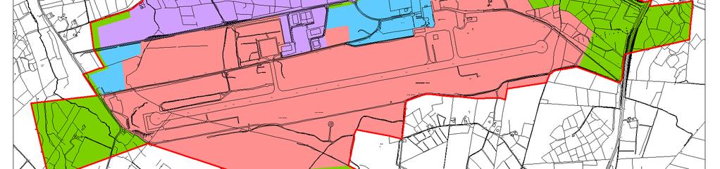
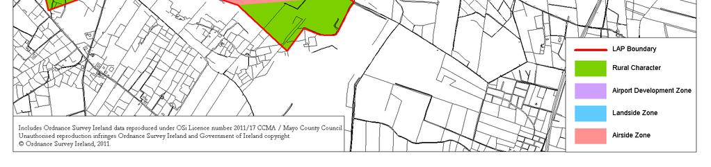
15 Map 3: Land Use Zoning 14
16 Rural Character Zone Objective: to protect the setting, character and environmental quality of Ireland West Airport Knock. The area covered by this zoning objective has experienced Pluvial Extreme and Fluvial Extreme flooding events. The sequential approach, outlined above, allows for all development proposals considered appropriate for this zoning objective (as outlined in the Ireland West Airport Knock LAP). The areas to the East and to the West, which includes the fluvial event are reserved and protected in the LAP for future navigational equipment. Any development that occurs will require surface water management mitigation measures outlined in Section below. Airport Development Zone Objective: to facilitate appropriate development in order to strengthen the strategic role of Ireland West Airport Knock as a key economic/enterprise hub for the region, whilst protecting the future operations of the Airport. There are no flood events indicated in the area zoned for Airport Development; as the LAP area is considered Flood Zone C all development proposals considered appropriate for this zoning objective (as outlined in the Ireland West Airport Knock LAP) are permitted. This area is undeveloped at present, therefore mitigation and surface water management will be necessary, and are outlined in Section below Flood Risk and Surface Water Management. The land use zoning strategy has been prepared to avoid and manage any flood risk that has been identified for the area. The LAP sets out policies, objectives and best practice approaches to militate against any further risk from flooding as a result of and arising from development of the area. The Local Area Plan includes the following objectives in relation to surface water management: SO2 It is an objective of the Council to support raising public awareness of the value of the water resources by encouraging conservation, reuse and protection of water, in addition to the elimination of wastage of water through waste-water detection and enforcement of repairs and to replace deficient sections of pipe work where necessary IO6 It is an objective of the Council to ensure surface water systems are managed in a sustainable manner by encouraging the re-use of surface water where possible and to require that all new development proposals provide surface water drainage systems designed in accordance with Sustainable Urban Drainage Systems (Suds) IO7 It is an objective of the Council to ensure that surface water is adequately and safely disposed of in a manner compatible with achieving and maintaining Salmonid water quality in the receiving waters. (S.I. No. 293/1988: European Communities (Quality of Salmonid Waters) Regulations HO9 It is an objective of the Council to comply with the EU Floods Directive 2007/60/EC and S.I. No. 122/2010: European Communities (Assessment and Management of Flood Risks) Regulations HO10 It is an objective of the Council to protect areas prone to flooding within the LAP area from inappropriate development and to ensure that all new developments do not result in an increased risk of flooding within the site or on other lands. All new development proposals within or close to flood risk areas shall submit a flood risk assessment which should incorporate flood protection and mitigation measures, as appropriate 15
17 The Ireland West Airport Knock Local Area Plan includes a section in the Development Management Standards and Guidelines that requires all development proposals to be accompanied by an Environmental Management Report., which should include surface water management proposals at all stages of the development application process. The LAP gives guidance on mitigation measures appropriate to the level of detail required depending on the development proposal. The Development Standards also requires that Surface Water Systems shall be designed in accordance with Suds (Sustainable Urban Drainage Systems) and Surface Water Attenuation provided in order to restrict flows from development to Greenfield run off rates Flooding Outside of the Ireland West Airport Knock LAP. The Draft Preliminary Flood Risk Assessment map indicates flooding events outside the Local Area Plan boundary. These are mainly categorised as Pluvial Extreme events relating to rainfall and pending. It has not been established if rainfall run-off from the existing airport campus is a contributing factor to these flooding events. It is considered that the implementation of the LAP will not contribute further to these events, and if the airport is a contributing factor, implementation of the surface water management mitigation measures of the LAP should either alleviate the flooding event or reduce any impact that the airport development may have on these flooding events. 2.4 Conclusion As a result of the Flood Risk Identification; the Initial Flood Risk Assessment (Stages 1 & 2); the application of the sequential approach outlined in the Planning System and Flood Risk Management, Guidelines for Planning Authorities, DoEHLG, 2009 and The Planning System and Flood Risk Management Guidelines for Planning Authorities; Technical Appendices; DoEHLG, 2009; and the incorporation of mitigation measures into the LAP, it is not considered necessary to subject the Ireland West Airport Knock LAP to Stage 3 Detailed Flood Risk Assessment. 16
Strategic Flood Risk Assessment
 Strategic Flood Risk Assessment Draft Claremorris Local Area Plan 2012 2018 Prepared by Forward Planning Section Mayo County Council 1 Table of Contents Section 1: Overview of the Guidelines... 4 1.1 Introduction...
Strategic Flood Risk Assessment
 PLANNING DEPARTMENT, KILKENNY COUNTY COUNCIL Strategic Flood Risk Assessment Proposed Amendment No. 2 of Callan Local Area Plan 2009-2020 Forward Planning January 2016 This Strategic Flood Risk Assessment
STRATEGIC FLOOD RISK ASSESSMENT
 STRATEGIC FLOOD RISK ASSESSMENT FOR PROPOSED VARIATION NO. 1 (CORE STRATEGY) TO THE LONGFORD TOWN DEVELOPMENT PLAN 2009-2015 for: Longford Local Authorities Great Water Street, Longford, Co. Longford by:
Sequential Flood Risk Test for Mid Sussex Neighbourhood Plans
 Sequential Flood Risk Test for Mid Sussex Neighbourhood Plans Introduction This Sequential Test has been prepared to assess the flood risk of sites within the parish that have been identified as suitable,
Strategic Flood Risk Assessment. SFRA Report
 Strategic Flood Risk Assessment SFRA Report on Strandhill Mini-Plan Variation No.1 of the Sligo County Development Plan 2011-2017 Prepared by Contents 1. The context for the Flood Risk Assessment 1 2.
Flood Risk and Land Use Vulnerability Guidance
 Flood Risk and Land Use Vulnerability Guidance UPS-BP-GU2a v.2 UNCONTROLLED DOCUMENT WHEN PRINTED Pag SCOTTISH ENVIRONMENT PROTECTION AGENCY Identifier: LUPS-GU24 Land Use Planning System SEPA Guidance
Planning and Flood Risk
 Planning and Flood Risk Patricia Calleary BE MEngSc MSc CEng MIEI After the Beast from the East Patricia Calleary Flood Risk and Planning Flooding in Ireland» Floods are a natural and inevitable part of
BLESSINGTON LOCAL AREA PLAN FLOOD RISK ASSESSMENT
 BLESSINGTON LOCAL AREA PLAN 2013-2019 FLOOD RISK ASSESSMENT Table of Contents Page Number 1.0 INTRODUCTION 1 1.1 Definition of Flooding 2 1.2 Policy Framework 2 1.3 Flood Risk Identification 3 1.4 Mapping
Comhairle Baile Cheanntair~ Nás na Ríogh
 Comhairle Baile Cheanntair~ Nás na Ríogh DRAFT STRATEGIC FLOOD RISK ASSESSMENT NAAS TOWN DEVELOPMENT PLAN 2011 ~ 2017 Kildare County Council Water Services Department Aras Chill Dara Devoy Park Naas County
Strategic Flood Risk Assessment
 Gorey Town and Environs Local Area Plan 207-2023 Appendix 4 Strategic Flood Risk Assessment April 207 Table of Contents Introduction and Context.... Introduction....2 Legislative and Planning context....2.
STAGE 2 STRATEGIC FLOOD RISK ASSESSMENT (AS AMENDED)
") STAGE 2 STRATEGIC FLOOD RISK ASSESSMENT (AS AMENDED) FOR PROPOSED AMENDMENTS TO THE CLIFDEN LOCAL AREA PLAN 2009-2015 for: Galway County Council County Buildings Prospect Hill Galway by: CAAS Ltd. 2 nd
STAGE 2 STRATEGIC FLOOD RISK ASSESSMENT (AS AMENDED) FOR PROPOSED AMENDMENTS TO THE CLIFDEN LOCAL AREA PLAN 2009-2015 for: Galway County Council County Buildings Prospect Hill Galway by: CAAS Ltd. 2 nd
Strategic Flood Risk Assessment for SDCC Development Plan
 Strategic Flood Risk Assessment for SDCC Development Plan Detailed Report on Flood Risk in the Baldonnell Area 8 th May 2015 rpsgroup.com/ireland Strategic Flood Risk Assessment for SDCC Development Plan
FOR TO THE GAELTACHT LOCAL AREA PLAN MARCH 2013
 APPENDIX II TO THE SEA ENVIRONMENTAL REPORT STAGE 2 STRATEGIC FLOOD RISK ASSESSMENT FOR PROPOSED AMENDMENT TO THE GAELTACHT LOCAL AREA PLAN 2008-2014 for: Galway County Council County Buildings Prospect
Flood Risk Assessment Appendix 1 to Strategic Environmental Assessment of Ferrybank/Belview Local Area Plan 2017
 Flood Risk Assessment Appendix 1 to Strategic Environmental Assessment of Ferrybank/Belview Local Area Plan 2017 Forward Planning Kilkenny County Council June 2017 Contents 1 Introduction... 1 1.1 Disclaimer...
Development and Flood Risk - the Environment Agency s approach to PPS25. scrutinised before planning decisions are made
 Development and Flood Risk - the Environment Agency s approach to PPS25 Steve Cook Flood Risk Policy Advisor Stephen.cook@environment-agency.gov.uk Our role in PPS25 h Providing advice and information
Flood Risk Assessment Appendix 1 to Strategic Environmental Assessment Screening of Amendment No. 1 to Ferrybank/Belview Local Area Plan
 Flood Risk Assessment Appendix 1 to Strategic Environmental Assessment Screening of Amendment No. 1 to Ferrybank/Belview Local Area Plan Forward Planning Kilkenny County Council 18/8/2011 1 Introduction
Flood Risk Assessment Cobh Town Plan Cobh Town Development Plan Volume 2: Strategic Flood Risk Assessment
 Flood Risk Assessment Cobh Town Plan 2013 Cobh Town Development Plan 2013 Volume 2: Strategic Flood Risk Assessment Cobh Town Plan 2013 Flood Risk Assessment Document Verification Page 1 of 1 Job Title:
Appendix 12.3 Flood Risk Assessment
 Appendix 12.3 Flood Risk Assessment Contents A12.3-1.1 Scope of Work 1 A12.3-1.2 Summary of Data Used 1 A12.3-1.3 Proposed Project 2 A12.3-2.1 The Planning System and Flood Risk Management Guidelines 2
STAGE 2 STRATEGIC FLOOD RISK ASSESSMENT
 STAGE 2 STRATEGIC FLOOD RISK ASSESSMENT FOR THE GORT LOCAL AREA PLAN2013-2019 for: Galway County Council County Buildings Prospect Hill Galway by: CAAS Ltd. 2 nd Floor, The Courtyard 25 Great Strand Street
Celbridge. Local Area Plan STRATEGIC FLOOD RISK ASSESSMENT
 Celbridge Local Area Plan 2017-2023 Dréachtphlean Ceantair Áitiúil Cill Droichid STRATEGIC FLOOD RISK ASSESSMENT Planning Department Kildare County Council September 2017 Strategic Flood Risk Assessment
STRATEGIC FLOOD RISK ASSESSMENT
 STRATEGIC FLOOD RISK ASSESSMENT UNDERTAKEN AS PART OF THE PREPARATION OF PROPOSED VARIATION NO. 2 (A) TO THE GALWAY COUNTY DEVELOPMENT PLAN 2015-2021 BEARNA PLAN for: Galway County Council Áras an Chontae
Document Control Sheet
 Strategic Flood Risk Assessment of the Maynooth Local Area Plan 2013-2019 Proposed Amendment No. 1 Document Control Sheet Client: Project Title: Document Title: Document No: Kildare County Council Strategic
Laois County Council Comhairle Chontae Laoise STRATEGIC FLOOD RISK ASSESSMENT PORTLAOISE DRAFT LOCAL AREA PLAN
 Laois County Council Comhairle Chontae Laoise STRATEGIC FLOOD RISK ASSESSMENT PORTLAOISE DRAFT LOCAL AREA PLAN 2018 2024 CONTENTS PORTLAOISE... 0 DRAFT LOCAL AREA PLAN... 0 2018 2024... 0 LIST OF FIGURES...
STRATEGIC FLOOD RISK ASSESSMENT
 STRATEGIC FLOOD RISK ASSESSMENT FOR THE SLIGO COUNTY DEVELOPMENT PLAN 2011-2017 for: Sligo County Council County Hall Riverside Sligo County Sligo by: CAAS Ltd. 2 nd Floor, The Courtyard 25 Great Strand
STAGE 2 STRATEGIC FLOOD RISK ASSESSMENT LONGFORD COUNTY DEVELOPMENT PLAN FEBRUARY 2015 FOR THE. Longford County Council. CAAS Ltd.
 STAGE 2 STRATEGIC FLOOD RISK ASSESSMENT FOR THE LONGFORD COUNTY DEVELOPMENT PLAN 2015-2021 for: Longford County Council Great Water Street Longford County Longford by: CAAS Ltd. 2 nd Floor, The Courtyard
The Planning System and Flood Risk Management Guidelines for Planning Authorities
 Technical Appendices November 2009 Contents PAGE A. Identification and Assessment of Flood Risk 1 B. Addressing Flood Risk Management in Design of Development 35 A Appendix A: Identification and Assessment
Environment Agency pre-application advice incorporating Local Flood Risk Standing Advice from East Lindsey District Council
 Environment Agency pre-application advice incorporating Local Flood Risk Standing Advice from East Lindsey District Council Version 1 UNCLASSIFIED We are the Environment Agency. We protect and improve
Flood Risk Management Planning in Scotland: Arrangements for February 2012
 Flood Risk Management Planning in Scotland: Arrangements for 2012 2016 February 2012 Flood Risk Management (Scotland) Act 2009 1 Contents Forewords 1. Introduction to this document... 5 2. Sustainable
Woodbrook - Shanganagh
 Strategic Flood Risk Assessment (SFRA) Woodbrook - Shanganagh Local Area Plan 2017-2023 Appendix 7 Strategic Flood Risk Assessment (SFRA) Woodbrook-Shanganagh Local Area Plan 2017-2023 August 2017 Appendix
Strategic Flood Risk Assessment (SFRA)
") Draft Sligo County Development Plan 2017-2023 for public consultation September 2016 Strategic Flood Risk Assessment (SFRA) Strategic Flood Risk Assessment (SFRA) of the Draft Sligo County Development
Draft Sligo County Development Plan 2017-2023 for public consultation September 2016 Strategic Flood Risk Assessment (SFRA) Strategic Flood Risk Assessment (SFRA) of the Draft Sligo County Development
Flood Risk Sequential Test
 Flood Risk Sequential Test Assessment of Proposed Development Sites Stroud District Council Evidence Base (December 2013) Development and Flood Risk Sequential Test 1.0 Introduction 1.1 This document considers
WG F 20 Workshop - Berlin
 WG F 20 Workshop - Berlin THE PLUVIAL PFRA IN IRELAND Mark Adamson Office of Public Works 4 th October, 2016 OVERALL APPROACH TO PFRA OVERALL APPROACH Risk Assessment Three-String Approach Historic FRA
FLOOD RISK MANAGEMENT IN IRELAND
 National Flood Management Conference 2018 FLOOD RISK MANAGEMENT IN IRELAND Mark Adamson Office of Public Works 15 th March, 2018 FLOOD RISK IN IRELAND NATIONAL RISK ASSESSMENT, OEP 2012 Flooding: Joint
Guildford Borough Level 1 Strategic Flood Risk Assessment Summary Report. January 2016
 Guildford Borough Level 1 Strategic Flood Risk Assessment Summary Report January 2016 What is this document? This document provides a summary of Guildford Borough Strategic Flood Risk Assessment (SFRA,
STRATEGIC FLOOD RISK ASSESSMENT
 STRATEGIC FLOOD RISK ASSESSMENT UNDERTAKEN AS PART OF THE PREPARATION OF PROPOSED VARIATION NO. 2 (B) TO THE GALWAY COUNTY DEVELOPMENT PLAN 2015-2021 GAELTACHT PLAN (INCLUDING SETTLEMENTS OF AN CHEATHRÚ
FLOOD SOLUTIONS Residence
 FLOOD SOLUTIONS Residence Report prepared on 22 Knighton Road, Liverpool, L4 9RD Report reference AEL028FLR022381 National grid reference 337815, 394462 Report prepared for Specimen Client Client reference
Engineers Ireland Annual Conference
 Engineers Ireland Annual Conference MANAGING FLOOD RISK AND BUILDING SUSTAINABLE COMMUNITIES Mark Adamson Office of Public Works 15 th May, 2015 FLOOD RISK IN IRELAND RECENT FLOODS November 2009: >1,600
Strategic Flood Risk Assessment (SFRA)
") Strategic Flood Risk Assessment (SFRA) July 2007 (Final) London Borough of Hounslow The Civic Centre Lampton Road Hounslow TW3 4DN July 2007 (Final) EXECUTIVE SUMMARY Introduction 1. The London Borough
Strategic Flood Risk Assessment (SFRA) July 2007 (Final) London Borough of Hounslow The Civic Centre Lampton Road Hounslow TW3 4DN July 2007 (Final) EXECUTIVE SUMMARY Introduction 1. The London Borough
2018 PREPARING FOR A CHANGING CLIMATE AND MANAGING THE RISING FLOOD RISK
 Ireland Water 2018 PREPARING FOR A CHANGING CLIMATE AND MANAGING THE RISING FLOOD RISK Mark Adamson Office of Public Works 25 th April, 2018 FLOOD RISK IN IRELAND NATIONAL RISK ASSESSMENT, OEP 2012 & 2017
THE EU FLOODS DIRECTIVE:
 Sixth Bulgarian Austrian Seminar THE EU FLOODS DIRECTIVE: EUROPEAN PRACTICE AND RESEARCH IN FLOOD RISK MANAGEMENT Mark Adamson Co-Chair, Working Group F Office of Public Works, IE 7 th November, 2013 PRESENTATION
DRAFT STRATEGIC ENVIRONMENTAL ASSESSMENT SCREENING REPORT. Climate Change Sectoral Adaptation Plan for Flood Risk Management ( )
") Office of Public Works DRAFT STRATEGIC ENVIRONMENTAL ASSESSMENT SCREENING REPORT Climate Change Sectoral Adaptation Plan for Flood Risk Management (2014-2019) Determination of the need for strategic environmental
Office of Public Works DRAFT STRATEGIC ENVIRONMENTAL ASSESSMENT SCREENING REPORT Climate Change Sectoral Adaptation Plan for Flood Risk Management (2014-2019) Determination of the need for strategic environmental
East Meath Local Area Plan
 East Meath Local Area Plan 2014-2020 Bettystown / Laytown / Mornington East / Donacarney / Mornington Volume 3 Appendix C Strategic Flood Risk Assessment Copyright JBA Consulting Engineers and Scientists
Draft Regional Spatial & Economic Strategy
 Eastern & Midland Regional Assembly Draft Regional Spatial & Economic Strategy Regional Flood Risk Appraisal Report Tionól Reigiúnach Oirthir agus Lár-Tíre Eastern and Midland Regional Assembly TABLE OF
CHAPTER 10 FLOOD RISK
 CHAPTER 10 FLOOD RISK 10.1 Introduction and Key Issues 10.1.1 This chapter describes the likely effects that the construction and operation of the Upgrade will have on flood risk. The potential effects
Strategic Flood Risk Assessment Report. Ireland 2040 Our Plan Draft National Planning Framework
 Strategic Flood Risk Assessment Report Ireland 2040 Our Plan Draft National Planning Framework TABLE OF CONTENTS 1 INTRODUCTION... 1 1.1 OBJECTIVE... 1 1.2 SFRA INTEGRATION WITH THE DRAFT NPF... 1 1.3
Volume. 10c. Clare County Development Plan Strategic Flood Risk Assessment
 Volume 10c Clare County Development Plan 2017 2023 Strategic Flood Risk Assessment Elizabeth Russell 24 Grove Island Corbally Limerick Ireland This report describes work commissioned by Brian McCarthy,
VULNERABILITY AND RISK ASSESSMENT FOR THE PFRA IN IRELAND
 WG F THEMATIC WORKSHOP FLOODS AND ECONOMICS VULNERABILITY AND RISK ASSESSMENT FOR THE PFRA IN IRELAND Mark Adamson 25 th October 2010 OVERVIEW OF PFRA OVERALL APPROACH Risk Assessment Historic FRA (What
MONAGHAN COUNTY COUNCIL. Strategic Flood Risk Assessment for County Monaghan
 MONAGHAN COUNTY COUNCIL Strategic Flood Risk Assessment for County Monaghan November2017 Table of Contents 1.0: Introduction Page: 5 1.1: Objectives Page: 5 1.2: Study Area Page: 5 1.3: EU Floods Directive
Flood Risk Management in Ireland. The National CFRAM Programme & overview of the Capital Works Programme. Click to add text
 Flood Risk Management in Ireland The National CFRAM Programme & overview of the Capital Works Programme Click to add text Dr. John Martin Office of Public Works Engineers Ireland's Local Government Seminar
Kirkwall (Potentially Vulnerable Area 03/05) Local Plan District Local authority Main catchment Orkney Orkney Islands Council Orkney coastal Backgroun
 Local Plan District Local authority Main catchment Orkney Orkney Islands Council Orkney coastal Backgroun") Kirkwall (Potentially Vulnerable Area 03/05) Local Plan District Orkney Local authority Orkney Islands Council Main catchment Orkney coastal Summary of flooding impacts 490 residential properties 460 non-residential
Kirkwall (Potentially Vulnerable Area 03/05) Local Plan District Orkney Local authority Orkney Islands Council Main catchment Orkney coastal Summary of flooding impacts 490 residential properties 460 non-residential
DRAFT APPROPRIATE ASSESSMENT SCREENING REPORT
 DRAFT APPROPRIATE ASSESSMENT SCREENING REPORT Climate Change Sectoral Adaptation Plan for Flood Risk Management (2014-2019) 2538_RP/003/C FRAM Section Office of Public Works 2538_RP/003/D CONTENTS 1.0
Prepared by... Ross Bryant BSc MSc CEnv MCIWEM C.WEM Chartered Senior Analyst
 JBA Project Manager Ross Bryant 24 Grove Island Corbally Limerick Ireland Revision History Revision Ref / Date Issued Amendments Issued to V1.0 February 2017 First Issue Clare County Council V2.0 March
Alyth (Potentially Vulnerable Area 08/04) Local Plan District Local authority Main catchment Tay Perth and Kinross Council Alyth Burn (River Tay) Back
 Local Plan District Local authority Main catchment Tay Perth and Kinross Council Alyth Burn (River Tay) Back") Alyth (Potentially Vulnerable Area 08/04) Local Plan District Tay Local authority Perth and Kinross Council Main catchment Alyth Burn (River Tay) Summary of flooding impacts 50 residential properties 20
Alyth (Potentially Vulnerable Area 08/04) Local Plan District Tay Local authority Perth and Kinross Council Main catchment Alyth Burn (River Tay) Summary of flooding impacts 50 residential properties 20
Background to the PFRA European Overview - UC9810.5b
 Background to the PFRA European Overview - UC9810.5b The individual Member State Reports reflect the situation as reported by the Member States to the European Commission in 2012 The situation in the MSs
Vulnerability and Risk Assessment for the PFRA in Ireland
 Vulnerability and Risk Assessment for the PFRA in Ireland Mark Adamson 1, Anthony Badcock 2 1 Office of Public Works, Ireland 2 Mott MacDonald Group, U.K. Abstract The Preliminary Flood Risk Assessment
LOW. Overall Flood risk. Flood considerations. Specimen Address, Specimen Town. Rivers and the Sea Low page 4. Historic Flood.
 Specimen Address, Specimen Town Overall Flood risk LOW Crown copyright and database rights 2018. Ordnance Survey licence 100035207 Groundsure Floodview complies with relevant Law Society practice notes
Chelmsford City Council. Level 1 and Level 2 Strategic Flood Risk Assessment. Final Report
 Chelmsford City Council Level 1 and Level 2 Strategic Flood Risk Assessment Final Report October 2017 This page has been left intentionally blank 2015s3715 Chelmsford SFRA L1 and L2 Final Report v1.0.docx
September 2014 Pagham Neighbourhood Plan
 September 2014 Pagham Neighbourhood Plan 2014-2029 Basic Conditions Statement Published by Pagham Parish Council for Consultation under the Neighbourhood Planning (General) Regulations 2012. 1 Pagham Neighbourhood
Canada s exposure to flood risk. Who is affected, where are they located, and what is at stake
 Canada s exposure to flood risk Who is affected, where are they located, and what is at stake Why a flood model for Canada? Catastrophic losses Insurance industry Federal government Average industry CAT
Fort William (Potentially Vulnerable Area 01/25) Local authority Main catchment The Highland Council Appin coastal Background This Potentially Vulnera
 Local authority Main catchment The Highland Council Appin coastal Background This Potentially Vulnera") Fort William (Potentially Vulnerable Area 01/25) Local authority The Highland Council Main catchment Appin coastal Summary of flooding impacts 100 residential properties 80 non-residential properties 520,000
Fort William (Potentially Vulnerable Area 01/25) Local authority The Highland Council Main catchment Appin coastal Summary of flooding impacts 100 residential properties 80 non-residential properties 520,000
Strategic Flood Risk Management
 Strategic Management Duncan McLuckie (NSW Department of Infrastructure and Natural Resources) Introduction This paper discusses what is meant by strategic flood risk management, who is responsible in New
Strategic Flood Risk Assessment January 2018
 January 2018 As part of the preparation of the Proposed Variation No. 6, Limerick County Development Plan 2010-2016 (as extended) Proposed Variation No. 6 to the Limerick County Development Plan 2010-2016
Protocol for the maintenance of flood and coastal risk management assets (England only) Version 4, 27/01/2014 UNCLASSIFIED
 Version 4, 27/01/2014 UNCLASSIFIED") Protocol for the maintenance of flood and coastal risk management assets (England only) Version 4, 27/01/2014 UNCLASSIFIED We are the Environment Agency. We protect and improve the environment and make
Protocol for the maintenance of flood and coastal risk management assets (England only) Version 4, 27/01/2014 UNCLASSIFIED We are the Environment Agency. We protect and improve the environment and make
Nairn Central (Potentially Vulnerable Area 01/18) Local authority Main catchment The Highland Council Moray coastal Background This Potentially Vulner
 Local authority Main catchment The Highland Council Moray coastal Background This Potentially Vulner") Nairn Central (Potentially Vulnerable Area 01/18) Local authority The Highland Council Main catchment Moray coastal Summary of flooding impacts At risk of flooding 350 residential 30 non-residential 340,000
Nairn Central (Potentially Vulnerable Area 01/18) Local authority The Highland Council Main catchment Moray coastal Summary of flooding impacts At risk of flooding 350 residential 30 non-residential 340,000
Lake District National Park Authority Strategic Flood Risk Assessment (SFRA)
") Strategic Flood Risk Assessment (SFRA) September 2007 (Final) The Lake District National Park Authority Murley Moss Oxenholme Road Kendal Cumbria LA9 7RL September 2007 i EXECUTIVE SUMMARY Introduction
Strategic Flood Risk Assessment (SFRA) September 2007 (Final) The Lake District National Park Authority Murley Moss Oxenholme Road Kendal Cumbria LA9 7RL September 2007 i EXECUTIVE SUMMARY Introduction
Solway Local Plan District 1 Flood risk management in Scotland 1.1 What is a Flood Risk Management Strategy? Flood Risk Management Strategies have bee
 Flood Risk Management Strategy Solway Local Plan District Section 1: Flood Risk Management in Scotland 1.1 What is a Flood Risk Management Strategy?... 1 1.2 How to read this Strategy... 1 1.3 Managing
an Inspector appointed by the Secretary of State for Communities and Local Government
 Appeal Decision Site visit made on 19 December 2016 by Geoff Underwood BA(Hons) PGDip(Urb Cons) MRTPI IHBC an Inspector appointed by the Secretary of State for Communities and Local Government Decision
LLDC Flood Risk Review Summary Report. Issue 2 13 January 2017
 Issue 2 13 January 2017 This report takes into account the particular instructions and requirements of our client. It is not intended for and should not be relied upon by any third party and no responsibility
SFRA for Variation 6a of the Limerick City Development Plan
 SFRA for Variation 6a of the Limerick City Development Plan 2010-2016 Strategic Flood Risk Assessment February 2017 Economic Development & Strategic Planning Limerick City & County Council 7-8 Patrick
National Flood Risk Management Plan. CFRAM Programme
 National Flood Risk Management Plan AND THE CFRAM Programme Gerard O Connell, Engineer-in-Charge, Regional Projects & Flood Advisory Office Environmental SPC, 27 th June, 2018 HISTORIC & POLICY CONTEXT
A vibrant community offering a new way of living. Clonburris Strategic Development Zone (SDZ) Draft Planning Scheme. Strategic Flood Risk Assessment
 Draft Planning Scheme. Strategic Flood Risk Assessment") A vibrant community offering a new way of living Clonburris Strategic Development Zone (SDZ) Draft Planning Scheme Strategic Flood Risk Assessment September 2017 Contents 1 Introduction... 1 1.1 Terms
A vibrant community offering a new way of living Clonburris Strategic Development Zone (SDZ) Draft Planning Scheme Strategic Flood Risk Assessment September 2017 Contents 1 Introduction... 1 1.1 Terms
Review of preliminary flood risk assessments (Flood Risk Regulations 2009): guidance for lead local flood authorities in England
: guidance for lead local flood authorities in England") Review of preliminary flood risk assessments (Flood Risk Regulations 2009): guidance for lead local flood authorities in England 25 January 2017 We are the Environment Agency. We protect and improve the
Review of preliminary flood risk assessments (Flood Risk Regulations 2009): guidance for lead local flood authorities in England 25 January 2017 We are the Environment Agency. We protect and improve the
in the EU A new EU legal context on the assessment and management of flood water.europa.eu Maria Brättemark, WFD Team, DG ENV.D.1, European Commission
 Setting the scene : Flood Risk Management in the EU A new EU legal context on the assessment and management of flood risks Maria Brättemark, WFD Team, DG ENV.D.1, European Commission water.europa.eu This
Flood Risk Management Strategy. Shetland
 Flood Risk Management Strategy Shetland Publication date: 14 December 2015 Terms and conditions Ownership: All intellectual property rights for Flood Risk Management Strategies are owned by SEPA or its
Celbridge, Co Kildare
 Celbridge, Co Kildare Flood Risk Assessment December 2018 Oldtown, Celbridge, Co. Kildare. JBA Project Manager David Casey Unit 3, Block 660 Greenogue Business Plaza, Greenogue Rathcoole, Dublin Revision
A GUIDE TO BEST PRACTICE IN FLOOD RISK MANAGEMENT IN AUSTRALIA
 A GUIDE TO BEST PRACTICE IN FLOOD RISK MANAGEMENT IN AUSTRALIA McLuckie D. For the National Flood Risk Advisory Group duncan.mcluckie@environment.nsw.gov.au Introduction Flooding is a natural phenomenon
Flood Risk Management Plan for the NORTH WESTERN River Basin (UoM01)
") Appropriate Assessment Determination in accordance with Regulation 42(11) of the European Communities (Birds and Natural Habitats) Regulations 2011 2015 Flood Risk Management Plan for the NORTH WESTERN
Appropriate Assessment Determination in accordance with Regulation 42(11) of the European Communities (Birds and Natural Habitats) Regulations 2011 2015 Flood Risk Management Plan for the NORTH WESTERN
Joint Lincolnshire Flood Risk and Drainage Management Strategy: Draft v.6.0:consultation Draft, : Annexes A-F
 Lincolnshire Flood Risk and Drainage Management Partnership Framework Lincolnshire Joint Flood Risk and Drainage Management Strategy Draft v.6.0 Consultation Draft 23 rd May 2012 Annexes A-F Joint Lincolnshire
Dornoch (Potentially Vulnerable Area 01/07) Local Plan District Highland and Argyll Local authority The Highland Council Main catchment Dornoch coasta
 Local Plan District Highland and Argyll Local authority The Highland Council Main catchment Dornoch coasta") Dornoch (Potentially Vulnerable Area 01/07) Local authority The Highland Council Main catchment Dornoch coastal Summary of flooding impacts
Dornoch (Potentially Vulnerable Area 01/07) Local authority The Highland Council Main catchment Dornoch coastal Summary of flooding impacts
Turriff (Potentially Vulnerable Area 06/07) Local Plan District Local authority Main catchment North East Aberdeenshire Council River Deveron Backgrou
 Local Plan District Local authority Main catchment North East Aberdeenshire Council River Deveron Backgrou") Turriff (Potentially Vulnerable Area 06/07) Local Plan District North East Local authority Aberdeenshire Council Main catchment River Deveron Summary of flooding impacts At risk of flooding
Turriff (Potentially Vulnerable Area 06/07) Local Plan District North East Local authority Aberdeenshire Council Main catchment River Deveron Summary of flooding impacts At risk of flooding
Broad-Scale Assessment of Urban Flood Risk Mark G. E. Adamson 1
 Broad-Scale Assessment of Urban Flood Risk Mark G. E. Adamson 1 1 Office of Public Works, Trim, Co. Meath, Ireland Abstract The Directive on the assessment and management of flood risks (2007/60/EC The
Shropshire Local Flood Risk Management Strategy. Summary for Consultation. July 2014
 Shropshire Local Flood Risk Management Strategy Summary for Consultation July 2014 SHROPSHIRE LOCAL FLOOD RISK MANAGEMENT STRATEGY 1 Introduction This Strategy is about managing flooding in Shropshire.
Clyde south - Port Glasgow to Inchinnan (Potentially Vulnerable Area 11/09) Local Plan District Clyde and Loch Lomond Local authority Inverclyde Counc
 Local Plan District Clyde and Loch Lomond Local authority Inverclyde Counc") Clyde south - Port Glasgow to Inchinnan (Potentially Vulnerable Area 11/09) Local Plan District Clyde and Loch Lomond Local authority Inverclyde Council, Renfrewshire Council Main catchment Firth of Clyde
Clyde south - Port Glasgow to Inchinnan (Potentially Vulnerable Area 11/09) Local Plan District Clyde and Loch Lomond Local authority Inverclyde Council, Renfrewshire Council Main catchment Firth of Clyde
Elgin (Potentially Vulnerable Area 05/05) Local Planning District Local authority Main catchment Findhorn, Nairn and Speyside The Moray Council River
 Local Planning District Local authority Main catchment Findhorn, Nairn and Speyside The Moray Council River") Elgin (Potentially Vulnerable Area 05/05) Findhorn, Nairn and Speyside Local authority The Moray Council Main catchment River Lossie Summary of flooding impacts Summary of flooding impacts At risk of flooding
Elgin (Potentially Vulnerable Area 05/05) Findhorn, Nairn and Speyside Local authority The Moray Council Main catchment River Lossie Summary of flooding impacts Summary of flooding impacts At risk of flooding
Objectives of this Briefing
 Eastern CFRAM Study (Catchment Flood Risk Assessment & Management) Stakeholders Briefing Poddle & Camac Watercourses Overview Grace Glasgow July 2013 Burns Beach near Brighton, Western Australia RPS has
LOCAL FLOOD RISK MANAGEMENT STRATEGY FOR HERTFORDSHIRE. STRATEGY (Vision) Part 1 of 4
 Part 1 of 4") LOCAL FLOOD RISK MANAGEMENT STRATEGY FOR HERTFORDSHIRE STRATEGY (Vision) Part 1 of 4 Geoperspectives 2011 Contents Executive Summary... 1 E1. Background... 1 E2. Relevance... 1 E3. Strategy Content...
LOCAL FLOOD RISK MANAGEMENT STRATEGY FOR HERTFORDSHIRE STRATEGY (Vision) Part 1 of 4 Geoperspectives 2011 Contents Executive Summary... 1 E1. Background... 1 E2. Relevance... 1 E3. Strategy Content...
Glasgow City centre (Potentially Vulnerable Area 11/16) Local Plan District Local authority Main catchment Clyde and Loch Lomond Glasgow City Council
 Local Plan District Local authority Main catchment Clyde and Loch Lomond Glasgow City Council") Glasgow City centre (Potentially Vulnerable Area 11/16) Local Plan District Clyde and Loch Lomond Local authority Glasgow City Council Main catchment River Clyde Summary of flooding impacts At risk of
Glasgow City centre (Potentially Vulnerable Area 11/16) Local Plan District Clyde and Loch Lomond Local authority Glasgow City Council Main catchment River Clyde Summary of flooding impacts At risk of
Chapter Flood Consequences
 Chapter 2.16. Flood Consequences 438 16. Flood Consequences 16.1. Introduction and Scope of Topic 16.1.1. This chapter identifies and describes the existing flood risk features along the route of the Scheme
Creetown (Potentially Vulnerable Area 14/17) Local Plan District Local authority Main catchment Dumfries and Galloway Solway Moneypool Burn Council Ba
 Local Plan District Local authority Main catchment Dumfries and Galloway Solway Moneypool Burn Council Ba") Creetown (Potentially Vulnerable Area 14/17) Local Plan District Solway Local authority Dumfries and Galloway Council Main catchment Moneypool Burn Summary of flooding impacts 90 residential properties
Creetown (Potentially Vulnerable Area 14/17) Local Plan District Solway Local authority Dumfries and Galloway Council Main catchment Moneypool Burn Summary of flooding impacts 90 residential properties
STATUTORY INSTRUMENTS. S.I. No. 122 of EUROPEAN COMMUNITIES (ASSESSMENT AND MANAGEMENT OF FLOOD RISKS) REGULATIONS 2010.
 REGULATIONS 2010.") STATUTORY INSTRUMENTS. S.I. No. 122 of 2010. EUROPEAN COMMUNITIES (ASSESSMENT AND MANAGEMENT OF FLOOD RISKS) REGULATIONS 2010. (Prn. A10/0432) 2 [122] S.I. No. 122 of 2010. EUROPEAN COMMUNITIES (ASSESSMENT
STATUTORY INSTRUMENTS. S.I. No. 122 of 2010. EUROPEAN COMMUNITIES (ASSESSMENT AND MANAGEMENT OF FLOOD RISKS) REGULATIONS 2010. (Prn. A10/0432) 2 [122] S.I. No. 122 of 2010. EUROPEAN COMMUNITIES (ASSESSMENT
Strategic Flood Risk Assessment: A Local Authority Perspective. Karyn Punchard, Weymouth & Portland Borough Council
 Strategic Flood Risk Assessment: A Local Authority Perspective Karyn Punchard, Weymouth & Portland Borough Council Workshop Flooding issues in Weymouth & Portland SFRA Level 1 2005/6 SFRA Level 2 2008/9
Comptroller and Auditor General Special Report. Strategic Planning for Flood Risk Management
 Comptroller and Auditor General Special Report Strategic Planning for Flood Risk Management Report number 92 December 2015 2 Strategic Planning for Flood Risk Management Report of the Comptroller and Auditor
Eddleston, Peebles, Innerleithen, Selkirk, Stow and Galashiels (Potentially Vulnerable Area 13/04) Local Plan District Local authority Main catchment
 Local Plan District Local authority Main catchment") Eddleston, Peebles, Innerleithen, Selkirk, Stow and Galashiels (Potentially Vulnerable Area 13/04) Local Plan District Tweed Local authority Scottish Borders Council Main catchment River Tweed Summary
Eddleston, Peebles, Innerleithen, Selkirk, Stow and Galashiels (Potentially Vulnerable Area 13/04) Local Plan District Tweed Local authority Scottish Borders Council Main catchment River Tweed Summary
Navan Development Plan
 Navan Development Plan 2013-2019 Flood Risk Assessment and Management Plan Adopted Report June 2014 County Hall Navan Meath 2013s7163 Navan DP SFRA v1 4 tracked changes accepted.docx JBA Consulting 24
FLOOD RISK MANAGEMENT GUIDELINES FOR LOCATION OF NEW FACILITIES FUNDED BY ALBERTA INFRASTRUCTURE
 FLOOD RISK MANAGEMENT GUIDELINES FOR LOCATION OF NEW FACILITIES FUNDED BY ALBERTA INFRASTRUCTURE June 2017 Flood Risk Management GUIDELINES for Location of New Facilities Funded by Alberta Infrastructure
Oran Park and Turner Road Precincts Section 94 Contributions Plan
 Oran Park and Turner Road Precincts Section 94 Contributions Plan Prepared for The Council of Camden Contents Page Number 1. Summary 1 1.1 Overview of this Plan 1 1.2 Works schedule and contribution rates
Nairn East and Auldearn (Potentially Vulnerable Area 05/08) Local Planning District Local authority Main catchment Findhorn, Nairn and Speyside The Hi
 Local Planning District Local authority Main catchment Findhorn, Nairn and Speyside The Hi") Nairn East and Auldearn (Potentially Vulnerable Area 05/08) Findhorn, Nairn and Speyside Local authority The Highland Council Main catchment River Nairn Summary of flooding impacts Summary of flooding
Nairn East and Auldearn (Potentially Vulnerable Area 05/08) Findhorn, Nairn and Speyside Local authority The Highland Council Main catchment River Nairn Summary of flooding impacts Summary of flooding
Flood Risk Assessment for Planning
 Flood Risk Assessment for Planning Report on: Sample Property, Sample Town, Sample Postcode Report prepared for: Report Reference: Report Date: Sample AEL-XXXX-FRA-XXXX 28 th October 2016 Client Reference:
Newton Stewart (Potentially Vulnerable Area 14/12) Local Plan District Local authority Main catchment Dumfries and Galloway Solway River Cree Council
 Local Plan District Local authority Main catchment Dumfries and Galloway Solway River Cree Council") Newton Stewart (Potentially Vulnerable Area 14/12) Local Plan District Solway Local authority Dumfries and Galloway Council Main catchment River Cree Summary of flooding impacts 210 residential properties
Newton Stewart (Potentially Vulnerable Area 14/12) Local Plan District Solway Local authority Dumfries and Galloway Council Main catchment River Cree Summary of flooding impacts 210 residential properties
Good Practice Guide. GPG 101 Document Owner: Steve Cook. Page 1 of 7.
 Good Practice Guide Producing flood risk hydraulic models and flood consequence assessments for development planning purposes Date Published: September 2015 GPG 101 Document Owner: Steve Cook Page 1 of