Appendix 1 Kick off meeting
|
|
|
- Ashlynn Malone
- 5 years ago
- Views:
Transcription
1 Appendix 1 Kick off meeting


2 WEST COG o o
3 Regional CRS Kick Off Meeting Notes Intro Info Towns must receive 500 points in order to receive 5% discount on insurance premiums. Each town will have their own rating. Elevation Certificates: All towns review elevation certificates, this is usually done by the Zoning department. There will be no issue in towns forwarding future elevation certificates to WestCOG. Towns expressed concern with obtaining older elevation certificates. Newtown indicated that towns can receive extra points for older certificates. Several years ago, Greenwich initiated a program to obtain all elevation certificates but they don t think they got them all. Danbury keeps a binder of all elevation certificates (so it sounds like they can easily give information on old certificates). Flood insurance for municipal buildings: Towns were not sure if they comply. Newtown indicated that insurance may be included as a rider on the town s general insurance policy. CRS Coordinator: All towns would like WestCOG to assist with process. MOU may be needed. Repetitive Loss Properties: WestCOG can provide this information. Questions over if this information is public. 320: Discussion on what entity should assume role of liaison. WestCOG offered assistance with answering s/calls/questions o Towns preferred to remain liaison as they have more information on their properties. Newtown indicated that towns should expect to receive more requests in the future as insurance rates rise. Discussion about a cheat sheet to provide information to help answer questions that are typically directed to town staff. Newtown suggested towns to start keeping logs of any discussions regarding these requests.
4 o If helpful, WestCOG can draft a template for a log/how to record these conversations/requests Discussion on what town employees typically respond to these requests in Greenwich all Land Use office staff members are involved in responding to these requests. o This highlights that all of these staff members will need to be trained on how to document/log these conversations. Historical Flood Info: Question on how many years back and what type of information is needed. Public Information/Letters: No towns do direct outreach to property owners in floodplains. WestCOG can assist with this Newtown indicated that many of the public outreach tasks overlap, and multiple tasks/points can be achieved with one effort. Information packets can be put together and displayed/distributed at town offices or library quick way to get points. 420: It can be difficult for towns to qualify their protected land unless there is a restricted covenant on deed or it is recorded somewhere. o Towns will still get points for protected land, but full points are not awarded unless the restriction is recorded. This task may require the town to pull a lot of files time consuming. Newtown s parcel data is linked to its deed information, but other towns are not. Towns would like WestCOG to identify open space parcels that overlap in flood zones. This would make it easier for towns to collect data on whether the parcel has a restricted covenant. 440: Points are awarded if maps/data layers are hosted online. WestCOG can assist with this task. Other: Darien requested WestCOG provide a chart identify which tasks WestCOG can work on and how many points each town will be at. This will help the towns determine how much effort is needed on their end to reach the 500-point level. If the towns decided to move forward, the audit process letter will require a CEO signature from each town. The point of contact for each town will be the same people who attended meeting.

5 WestCOG Regional CRS Pilot Program Greenwich, Darien, Norwalk, Danbury 1

6 Meeting Agenda I. Introductions II. III. IV. Regional CRS Background Info Program Expectations Strategy for CRS Credits V. Next Steps 2
7 I. Introductions Denise Savageau (Greenwich) Katie DeLuca (Greenwich) Jeremy Ginsberg (Darien) Michael Wrinn (Norwalk) Jennifer Emminger (Danbury) Rob Sibley (Newtown) Mike Towle (WestCOG) Dave Hannon (WestCOG) Francis Pickering (WestCOG) 3

8 II. Regional CRS Background Info CRS Challenges Savings Cost Requires a variety of resources It s an additional effort Regional Solutions Savings > Cost Ready access to resources WestCOG is focusing on services 4
9 II. Regional CRS Background Info Cont. Flood Map Inquiries (Outreach) Flood Protection Information (GIS) Open Space Preservation (GIS) Stormwater Management (MS4) Flood Management Planning (HMP) Community c320 c350 c420 c450 c510 Total Points East Lyme Milford Newtown Stamford ,594 Stonington (Borough) Stonington (Town) West Hartford ,108 Westport ,169 Regional CRS Program * * * Connecticut Average Credit Connecticut % of Communities 88% 63% 100% 88% 25% 5
10 Expected Savings 65% of the policies 57% of the premiums 38% of realized savings * Currently take part in the CRS program. ** Projected discounts include customized municipal open space credits, based off a preliminary GIS analysis. Actual savings may vary and are contingent upon more detailed and localized analyses. Source: DEEP 12/31/2014, CRS.org CT State Profile 1/2014 6
11 III. Program Expectations Municipal Requirements Elevation Certificates NFIP Compliant Maintain flood insurance policies on municipal properties WestCOG Requirements Monitor repetitive loss properties Acting CRS coordinator Recertify each year 7
12 IV. Strategy Goal: Reach 500 credits (Tier 9) Category Activity Points Max Agency 310 Elevation Certfiicate Municipal 320 Mapping WestCOG 330 Outreach WestCOG 340 Hazard Disclosure 5 80 Municipal 350 Flood Protection Information Both 420 Openspace Preservation * 2020 WestCOG 440 Flood Data Maintenance WestCOG 450 Stormwater Management * 755 Municipal 510 Flood Plain Management Planning WestCOG 630 Dams State Sum * Activity will vary from town to town 8
13 310 Elevation Certificates Need 90% accuracy when reviewed for the CRS audit. Building department typically reviews these documents WestCOG needs method to acquire these once a year to scan and for documentation. 9
14 320 Mapping (outreach) Provide contact, and phone to address issues regarding flood map information and how to read flood maps. is Ideal, since its recorded information Phone is also required. Anticipate few calls Map information can be provided online through a web map This opportunity must be publicized once a year Discussions outside the NFIP can be turned towards the municipalities. 10
15 330 Outreach Can create a package of outreach materials to be stored at each municipality. Each flyer is worth a point. 200 point Cap All additional outreach efforts count as well Do Not Dump Stencils on storm drains Presentations Newsletters mailings 11
16 340 Hazard Disclosure (free points!) This is a state mandate, sellers must disclose if a property has been flooded before. 5 points 12
17 350 Flood Protection Information Storing FEMA and flood resources at the library (20) Hosting a website (76 points) Easy points, WestCOG can host the materials, and prepare the library documents. 13
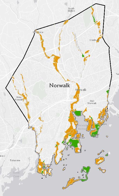
18 420 Open Space Preservation GIS analysis calculates % of flood zone preserved as protected open space. Darien Danbury Norwalk Greenwich Norwalk received 36/ Stamford 235/ Westport 238/
19 440 Flood Data Maintenance GIS warehouse of flood data. 142 Old FIRMS 15 15
20 450 Storm Water Maintenance Ties into new stormwater regs. Updates to any ordinacnes might provide additional CRS points. 440 points in this one 16
21 510 Flood Plain Management Plan Demanding HMP provides big points. 17
22 Next Steps Establish CRS Coordinator Needs confidence of the CEO and be authorized to sign CRS related documents on behalf of the community. Establish municipal point of contact Prepare CRS application Open space documentation Provide training on building elevation certificates Coordinate ISO/CRS specialist visit 18
23 19
24 Michael Towle From: Sent: To: Subject: Attachments: Michael Towle Friday, July 7, :13 AM 'Jennifer Emminger RE: Danbury CRS Follow Up Danbury - Regional CRS Enrollment Letter.docx Hi Jennifer, I met with Norwalk yesterday and they also requested some changes. Following that discussion I modified the language in the letter to join WestCOG s Regional CRS Program to include: A statement on leaving the program; Danbury can leave the program at any time for any reason, WestCOG will work in coordination with the planning department In the responsibilities section it states I will provide an annual update on the program. Let me know if you need any additional modifications. Best, Mike Towle From: Michael Towle Sent: Thursday, July 6, :06 PM To: Jennifer Emminger (j.emminger@danbury-ct.gov) <j.emminger@danbury-ct.gov> Subject: Danbury CRS Follow Up Greetings Jennifer, Good discussion today. Below I ve recorded all of the next steps we discussed. WestCOG will research what level of verification is required that municipal buildings are flood insured. WestCOG will verify upcoming deadlines for the verification visit WestCOG will find out if CRS savings are mentioned in the insurance bill. WestCOG will outline explicitly the activities that WestCOG will perform within this program and those that the town are responsible for. o Danbury will use this list to craft new language defining the CRS coordinator s role in the signed letter. WestCOG will send a list of all the CRS activities with a flag for which activities are performed by the COG. o Danbury will flag activities if feels it can potentially accomplish o WestCOG will review the additional activities, determine required documentation, provide recommendations on which ones to pursue, and then sum this sum of potential credits. WestCOG will set up a shared dropbox folder to allow for transparent data exchange WestCOG will set up a monthly schedule to identify deadlines WestCOG is developing a Regional CRS database inventory WestCOG will send out alerts on upcoming CRS deadlines CRS program takes a year to authorize once sent out. New scores are usually tallied every 5 years. Program is operating under assumption the COG will receive Regional Services Funding. In case funding fails to arrive, COG is prepared to train municipal staff if interested in taking the program on. 1
25 Enjoy that Yankees game! Mike Towle Planner WestCOG
26 Michael Towle From: Sent: To: Subject: Ginsberg, Jeremy Wednesday, August 2, :28 PM Michael Towle Accepted: Darien CRS Strategy 1
27 Michael Towle Subject: Location: Start: End: Recurrence: Meeting Status: Organizer: Regional CRS information session/discussion conference call Mon 6/19/2017 9:30 AM Mon 6/19/ :30 AM (none) Accepted DeLuca, Katie Good morning, We touched base on meeting regarding the Regional CRS program. I was hoping we are all available on Monday for a conference call with Mike Towle from WestCog. He can give us all the background information and we can go from there. Lets meet in my office, we can conference call Mike from there. Thanks, Katie 1
28 Michael Towle From: Sent: To: Subject: Kleppin, Steven Friday, July 7, :05 AM Michael Towle; Strauch, Frank RE: FEMA CRS -Norwalk Looks fine to me. From: Michael Towle Sent: Friday, July 7, :09 AM To: Strauch, Frank Cc: Kleppin, Steven Subject: RE: FEMA CRS -Norwalk Whoops I was a bit too quick with that copy and paste job. Attached is an updated copy with copy and paste errors resolved. The following text was changed. CRS Coordinator Designation Harry W. Rilling, Mayor of Norwalk, designates Michael Towle, Planner at Western Connecticut Council of Governments (WestCOG), to serve as the CRS Coordinator for the City of Norwalk. The CRS Coordinator will work in coordination with the Norwalk Planning and Zoning department when requesting documentation and assistance from the various community departments and in the signing of CRS-related documents. From: Michael Towle Sent: Friday, July 7, :54 AM To: 'Strauch, Frank' <FStrauch@norwalkct.org> Cc: Kleppin, Steven <skleppin@norwalkct.org> Subject: RE: FEMA CRS -Norwalk Greetings Frank, Here is a new draft on the letter to join WestCOG s Regional CRS Program. I included text to include A statement on leaving the program; Norwalk can leave the program at any time for any reason, WestCOG will work in coordination with the planning department In the responsibilities section it states I will provide an annual update to the common council. Let me know if you need any additional modifications. I m currently on setting up the credit list, for you to review and flag additional activities, Norwalk would be interested in pursuing. Best, Mike Towle 1
29 From: Strauch, Frank Sent: Thursday, July 6, :49 AM To: Michael Towle Cc: Kleppin, Steven Subject: FEMA CRS -Norwalk Importance: High Mike, This is just a friendly reminder to attend the Planning Committee of the Common Council regarding our participation in FEMA s CRS. Steve and I appreciate you taking the time to do this. Frank Agenda: Frank J. Strauch, RLA Site Planner Planning & Zoning Department City of Norwalk, Connecticut 125 East Avenue PO BOX 5125 Norwalk, CT office fax fstrauch@norwalkct.org Planning & Zoning Office Hours: Mon. - Thurs. 8:30 AM to 3:00PM (Closed 12:30 to 1:30 PM) Friday 8:30 AM to 3:00 PM (Closed 11 AM to 12 Noon & Closed 12:30 to 1:30 PM) Afternoons are by apponintment only. 2
30 Appendix 2 Letters of Interest


31


32
33
34


35


36


37

38


39


40
41 Appendix 3 Quick Checks
42 Community Name NFIP Number Population Application Date CRS Quick Check Norwalk State CT BCEGS 10 FIRM Effective Date 88,418 (2016) Current FIRM Date County Fairfield Chief Executive Officer Name Harry Rilling Michael Towle Title Mayor Planner Address City Hall 1 Riverside Rd Address 125 East Ave Sandy Hook, CT CRS Coordinator's phone CRS Coordinator's mtowle@westcog.org CRS Coordinator Fax Section Prerequisites Met Can Meet Enter 211 a(2) a(4) a(4) a(5) Have you had a Community Assistance Visit that concluded you are in full compliance with the NFIP? How many repetitive loss properties are there in your community? What is your repetitive loss category? (A = no rep losses, B = 1-9, C = 10 or more) Have you maintained flood insurance policies on all buildings that have been required to have one? 213 a a How many buildings are in your community's Special Flood Hazard Area? How large is your community's Special Flood Hazard Area (in acres)? CRS Activities and Elements Now Could Credit Max 310 a Will you keep FEMA Elevation Certificates on all new buildings and substantial improvements in the SFHA? b Do you have FEMA Elevation Certificates on buildings built before your CRS application? a Are you willing to publicize that you will read FIRMs for inquirers and keep a record of what you told them? b Do you provide inquirers with other non-insurance related information that is shown on your FIRM? c Do you provide information about flood problems other than those shown on the FIRM? d Do you provide information about flood depths? e Do you provide information about special flood-related hazards, such as erosion, subsidence, or tsunamis? f Do you provide information about past flooding at or near the site in question? g Do you provide information about areas that should be protected because of their natural floodplain functions? 330 a Enter 2 points for each flood-related informational brochure, flyer, or other document that is set out for the public to pick up. 200 a Enter 4 points for each flood-related newsletter, presentation, or other outreach project that is implemented every year. 340 a Do real estate agents actively advise house hunters if a property is located in a Special Flood Hazard Area? b Are there state or local requirements that sellers must disclose whether a property has been flooded? c Do real estate agents give house hunters a brochure or handout advising them to check out the flood hazard before they 8 12 buy? 350 a Do you have any flood-related references in your public library? Page 1 of 12
43 CRS Quick Check Community Name Norwalk State CT BCEGS 10 c Do you have flood-related information or links on your community's website? a,b Do you visit homes and help people determine how they could reduce their flooding or drainage problem? c Do you talk to people about sources of financial assistance for flood or drainage protection measures? Have you reviewed all your community's flood insurance policies and analyzed where coverage should be improved? a Have you conducted your own flood studies and do you use the data when regulating new development? a Do you provide (or require the developer to provide) base flood elevations in approximate A Zones? b Did your community contribute to the cost of a Flood Insurance Study (e.g., provided cash or a base map with better 0 topography)? 420 a What percentage of your Special Flood Hazard Area is kept as park or other publicly preserved open space? 0% 3% 0% 100% The percentage is multiplied by 1,450 to obtain the score ,450 c Are some of those parks or other publicly preserved open spaces preserved in or restored to their original natural state? e Does your community have density transfers or other regulations to encourage developers to keep the SFHA as open space? f What percentage of your SFHA is zoned for minimum lot sizes of 5 acres or larger? 0% 0% 0% 100% The percentage is multiplied by 300 to obtain the score a(1) Does your community prohibit filling or require compensatory storage in all or parts of the SFHA? a(2) Does your community prohibit certain types of buildings from all or parts of the SFHA? 100 1,000 a(3) Does your community prohibit or limit the storage of hazardous materials from all or parts of the SFHA? b Does your community have a freeboard requirement? c Do you have compaction and erosion protection requirements for fill that is used to support buildings? d Do you track building improvements and repairs cumulatively and add the values up to reach the 50% threshold? d Do you define substantial damage to include two floods in 10 years with average damage at 25% of the building s value? f Do you require critical facilities to be protected to the 500-year flood level? g Do you require a nonconversion agreement signed by the permit applicant for an elevated building? h Does your community enforce the International Building and Residential Codes (IBC and IRC)? If your BCEGS class is 5/5 or better, your BCEGS credit is calculated automatically i Do you have regulations that ensure that every new building will be built to be protected from local drainage flooding? o Enter 5 points for every CFM or graduate of an EMI NFIP course, up to a maximum of 25 points o Do you keep paper records at a secure offsite storage site or scan them and back up the files? a Is your FIRM on a local geographic information system (GIS) layer and does the GIS also show streets and parcels? b Have you kept copies of all your old FIRMs? c Use the handout, "CRS Credit for Benchmark Maintenance," to see if there are any qualifying benchmarks in the National 5 27 Spatial Reference System. 450 a Do you require new developments to build stormwater retention or detention basins? Page 2 of 12
44 CRS Quick Check Community Name Norwalk State CT BCEGS 10 c Do you have permit records that show that you require new developments to control erosion from construction projects? d Do you have permit records that show that you require new stormwater facilities to include water quality provisions? 510 a Have you adopted a floodplain management or hazard mitigation plan that has been approved by FEMA? c Have you adopted a plan to protect aquatic or riparian species or other natural floodplain functions? Enter 3 points for every building that has been cleared out of the floodplain up to a maximum of 190 points. N/A 2, Enter 2.4 points for every pre-firm building that has been elevated voluntarily, up to a maximum of 160 points. N/A 1, a Do you have a program to regularly inspect streams, ditches, and other channels and to remove debris when found? c If you have credit for 540.a, do you have a capital improvements program for drainage improvements? d If you have credit for 540.a, do you have an ordinance the prohibits dumping debris, junk, grass, etc., in drainageways? e If you have credit for 450.a, do you have a program to regularly inspect storage basins and to remove debris when found? a - d Do you have a system for getting notification when flooding is expected (more than listening to the radio)? Do you have a flood response plan (or flood annex to the emergency plan) that specifies what to do after a flood notification? Do you have a master list of critical facilities in the floodplain and arrangements for special warnings to them? e, f Are you a StormReady or TsunamiReady community? (see a - e Do you have a levee, a levee maintenance program, and a levee failure warning and response plan (similar to 610 a-d)? Is there an annual outreach project sent to properties in the area that would flood if the levee were overtopped? 630 a Is your community threatened by a failure of an upstream dam? If so, enter the credit for the state's dam safety program i.e., the value for "SDS" from the "Dam Safety Scores" tab in this Excel file. b - e Do you have a dam failure warning and response plan (similar to 610 a-d)? Is there an annual outreach project sent to properties in the area that would be flooded if the dam failed? 710 Enter your county's growth rate, i.e., the value for "CGA" from the right column on the "Growth Rates" tab in this Excel file Total Total "Now" + "Could" Product Potential CRS Class Now Could Page 3 of 12
45 Community Name NFIP Number Population Application Date CRS Quick Check Greenwich State CT BCEGS 10 FIRM Effective Date 62,434 ( ) Current FIRM Date County Fairfield Chief Executive Officer Name Peter J. Tesei Michael Towle Title First Selectman Planner Address 101 Field Point Rd 1 Riverside Rd Address Greenwich, CT Sandy Hook, CT CRS Coordinator's phone CRS Coordinator's mtowle@westcog.org CRS Coordinator Fax Section Prerequisites Met Can Meet Enter 211 a(2) Have you had a Community Assistance Visit that concluded you are in full compliance with the NFIP? x a(4) How many repetitive loss properties are there in your community? a(4) What is your repetitive loss category? (A = no rep losses, B = 1-9, C = 10 or more) c a(5) Have you maintained flood insurance policies on all buildings that have been required to have one? x 213 a a How many buildings are in your community's Special Flood Hazard Area? How large is your community's Special Flood Hazard Area (in acres)? CRS Activities and Elements Now Could Credit Max 310 a Will you keep FEMA Elevation Certificates on all new buildings and substantial improvements in the SFHA? b Do you have FEMA Elevation Certificates on buildings built before your CRS application? a Are you willing to publicize that you will read FIRMs for inquirers and keep a record of what you told them? b Do you provide inquirers with other non-insurance related information that is shown on your FIRM? c Do you provide information about flood problems other than those shown on the FIRM? d Do you provide information about flood depths? e Do you provide information about special flood-related hazards, such as erosion, subsidence, or tsunamis? f Do you provide information about past flooding at or near the site in question? g Do you provide information about areas that should be protected because of their natural floodplain functions? 330 a Enter 2 points for each flood-related informational brochure, flyer, or other document that is set out for the public to pick up. 200 a Enter 4 points for each flood-related newsletter, presentation, or other outreach project that is implemented every year. 340 a Do real estate agents actively advise house hunters if a property is located in a Special Flood Hazard Area? b Are there state or local requirements that sellers must disclose whether a property has been flooded? c Do real estate agents give house hunters a brochure or handout advising them to check out the flood hazard before they 8 12 buy? 350 a Do you have any flood-related references in your public library? Page 4 of 12
46 CRS Quick Check Community Name Greenwich State CT BCEGS 10 c Do you have flood-related information or links on your community's website? a,b Do you visit homes and help people determine how they could reduce their flooding or drainage problem? c Do you talk to people about sources of financial assistance for flood or drainage protection measures? Have you reviewed all your community's flood insurance policies and analyzed where coverage should be improved? a Have you conducted your own flood studies and do you use the data when regulating new development? a Do you provide (or require the developer to provide) base flood elevations in approximate A Zones? b Did your community contribute to the cost of a Flood Insurance Study (e.g., provided cash or a base map with better 0 topography)? 420 a What percentage of your Special Flood Hazard Area is kept as park or other publicly preserved open space? 0% 22% 0% 100% The percentage is multiplied by 1,450 to obtain the score ,450 c Are some of those parks or other publicly preserved open spaces preserved in or restored to their original natural state? e Does your community have density transfers or other regulations to encourage developers to keep the SFHA as open space? f What percentage of your SFHA is zoned for minimum lot sizes of 5 acres or larger? 0% 0% 0% 100% The percentage is multiplied by 300 to obtain the score a(1) Does your community prohibit filling or require compensatory storage in all or parts of the SFHA? a(2) Does your community prohibit certain types of buildings from all or parts of the SFHA? 100 1,000 a(3) Does your community prohibit or limit the storage of hazardous materials from all or parts of the SFHA? b Does your community have a freeboard requirement? c Do you have compaction and erosion protection requirements for fill that is used to support buildings? d Do you track building improvements and repairs cumulatively and add the values up to reach the 50% threshold? d Do you define substantial damage to include two floods in 10 years with average damage at 25% of the building s value? f Do you require critical facilities to be protected to the 500-year flood level? g Do you require a nonconversion agreement signed by the permit applicant for an elevated building? h Does your community enforce the International Building and Residential Codes (IBC and IRC)? If your BCEGS class is 5/5 or better, your BCEGS credit is calculated automatically i Do you have regulations that ensure that every new building will be built to be protected from local drainage flooding? o Enter 5 points for every CFM or graduate of an EMI NFIP course, up to a maximum of 25 points o Do you keep paper records at a secure offsite storage site or scan them and back up the files? a Is your FIRM on a local geographic information system (GIS) layer and does the GIS also show streets and parcels? b Have you kept copies of all your old FIRMs? c Use the handout, "CRS Credit for Benchmark Maintenance," to see if there are any qualifying benchmarks in the National 5 27 Spatial Reference System. 450 a Do you require new developments to build stormwater retention or detention basins? Page 5 of 12
47 CRS Quick Check Community Name Greenwich State CT BCEGS 10 c Do you have permit records that show that you require new developments to control erosion from construction projects? d Do you have permit records that show that you require new stormwater facilities to include water quality provisions? 510 a Have you adopted a floodplain management or hazard mitigation plan that has been approved by FEMA? c Have you adopted a plan to protect aquatic or riparian species or other natural floodplain functions? Enter 3 points for every building that has been cleared out of the floodplain up to a maximum of 190 points. N/A 2, Enter 2.4 points for every pre-firm building that has been elevated voluntarily, up to a maximum of 160 points. N/A 1, a Do you have a program to regularly inspect streams, ditches, and other channels and to remove debris when found? c If you have credit for 540.a, do you have a capital improvements program for drainage improvements? d If you have credit for 540.a, do you have an ordinance the prohibits dumping debris, junk, grass, etc., in drainageways? e If you have credit for 450.a, do you have a program to regularly inspect storage basins and to remove debris when found? a - d Do you have a system for getting notification when flooding is expected (more than listening to the radio)? Do you have a flood response plan (or flood annex to the emergency plan) that specifies what to do after a flood notification? Do you have a master list of critical facilities in the floodplain and arrangements for special warnings to them? e, f Are you a StormReady or TsunamiReady community? (see a - e Do you have a levee, a levee maintenance program, and a levee failure warning and response plan (similar to 610 a-d)? Is there an annual outreach project sent to properties in the area that would flood if the levee were overtopped? 630 a Is your community threatened by a failure of an upstream dam? If so, enter the credit for the state's dam safety program i.e., the value for "SDS" from the "Dam Safety Scores" tab in this Excel file. b - e Do you have a dam failure warning and response plan (similar to 610 a-d)? Is there an annual outreach project sent to properties in the area that would be flooded if the dam failed? 710 Enter your county's growth rate, i.e., the value for "CGA" from the right column on the "Growth Rates" tab in this Excel file Total Total "Now" + "Could" Product Potential CRS Class Now Could , Page 6 of 12
48 Community Name NFIP Number Population Application Date CRS Quick Check Darien State CT BCEGS 10 FIRM Effective Date 21,392 ( ) Current FIRM Date County Fairfield Chief Executive Officer Name Jayme Stevenson Michael Towle Title First Selectman Planner Address 2 Renshaw Road 1 Riverside Rd Address Darien, CT Sandy Hook, CT CRS Coordinator's phone CRS Coordinator's mtowle@westcog.org CRS Coordinator Fax Section Prerequisites Met Can Meet Enter 211 a(2) a(4) a(4) a(5) Have you had a Community Assistance Visit that concluded you are in full compliance with the NFIP? How many repetitive loss properties are there in your community? What is your repetitive loss category? (A = no rep losses, B = 1-9, C = 10 or more) Have you maintained flood insurance policies on all buildings that have been required to have one? 213 a a How many buildings are in your community's Special Flood Hazard Area? How large is your community's Special Flood Hazard Area (in acres)? CRS Activities and Elements Now Could Credit Max 310 a Will you keep FEMA Elevation Certificates on all new buildings and substantial improvements in the SFHA? b Do you have FEMA Elevation Certificates on buildings built before your CRS application? a Are you willing to publicize that you will read FIRMs for inquirers and keep a record of what you told them? b Do you provide inquirers with other non-insurance related information that is shown on your FIRM? c Do you provide information about flood problems other than those shown on the FIRM? d Do you provide information about flood depths? e Do you provide information about special flood-related hazards, such as erosion, subsidence, or tsunamis? f Do you provide information about past flooding at or near the site in question? g Do you provide information about areas that should be protected because of their natural floodplain functions? 330 a Enter 2 points for each flood-related informational brochure, flyer, or other document that is set out for the public to pick up. 200 a Enter 4 points for each flood-related newsletter, presentation, or other outreach project that is implemented every year. 340 a Do real estate agents actively advise house hunters if a property is located in a Special Flood Hazard Area? b Are there state or local requirements that sellers must disclose whether a property has been flooded? c Do real estate agents give house hunters a brochure or handout advising them to check out the flood hazard before they 8 12 buy? 350 a Do you have any flood-related references in your public library? Page 7 of 12
49 CRS Quick Check Community Name Darien State CT BCEGS 10 c Do you have flood-related information or links on your community's website? a,b Do you visit homes and help people determine how they could reduce their flooding or drainage problem? c Do you talk to people about sources of financial assistance for flood or drainage protection measures? Have you reviewed all your community's flood insurance policies and analyzed where coverage should be improved? a Have you conducted your own flood studies and do you use the data when regulating new development? a Do you provide (or require the developer to provide) base flood elevations in approximate A Zones? b Did your community contribute to the cost of a Flood Insurance Study (e.g., provided cash or a base map with better 0 topography)? 420 a What percentage of your Special Flood Hazard Area is kept as park or other publicly preserved open space? 0% 9% 0% 100% The percentage is multiplied by 1,450 to obtain the score ,450 c Are some of those parks or other publicly preserved open spaces preserved in or restored to their original natural state? e Does your community have density transfers or other regulations to encourage developers to keep the SFHA as open space? f What percentage of your SFHA is zoned for minimum lot sizes of 5 acres or larger? 0% 0% 0% 100% The percentage is multiplied by 300 to obtain the score a(1) Does your community prohibit filling or require compensatory storage in all or parts of the SFHA? a(2) Does your community prohibit certain types of buildings from all or parts of the SFHA? 100 1,000 a(3) Does your community prohibit or limit the storage of hazardous materials from all or parts of the SFHA? b Does your community have a freeboard requirement? c Do you have compaction and erosion protection requirements for fill that is used to support buildings? d Do you track building improvements and repairs cumulatively and add the values up to reach the 50% threshold? d Do you define substantial damage to include two floods in 10 years with average damage at 25% of the building s value? f Do you require critical facilities to be protected to the 500-year flood level? g Do you require a nonconversion agreement signed by the permit applicant for an elevated building? h Does your community enforce the International Building and Residential Codes (IBC and IRC)? If your BCEGS class is 5/5 or better, your BCEGS credit is calculated automatically i Do you have regulations that ensure that every new building will be built to be protected from local drainage flooding? o Enter 5 points for every CFM or graduate of an EMI NFIP course, up to a maximum of 25 points o Do you keep paper records at a secure offsite storage site or scan them and back up the files? a Is your FIRM on a local geographic information system (GIS) layer and does the GIS also show streets and parcels? b Have you kept copies of all your old FIRMs? c Use the handout, "CRS Credit for Benchmark Maintenance," to see if there are any qualifying benchmarks in the National 5 27 Spatial Reference System. 450 a Do you require new developments to build stormwater retention or detention basins? Page 8 of 12
50 CRS Quick Check Community Name Darien State CT BCEGS 10 c Do you have permit records that show that you require new developments to control erosion from construction projects? d Do you have permit records that show that you require new stormwater facilities to include water quality provisions? 510 a Have you adopted a floodplain management or hazard mitigation plan that has been approved by FEMA? c Have you adopted a plan to protect aquatic or riparian species or other natural floodplain functions? Enter 3 points for every building that has been cleared out of the floodplain up to a maximum of 190 points. N/A 2, Enter 2.4 points for every pre-firm building that has been elevated voluntarily, up to a maximum of 160 points. N/A 1, a Do you have a program to regularly inspect streams, ditches, and other channels and to remove debris when found? c If you have credit for 540.a, do you have a capital improvements program for drainage improvements? d If you have credit for 540.a, do you have an ordinance the prohibits dumping debris, junk, grass, etc., in drainageways? e If you have credit for 450.a, do you have a program to regularly inspect storage basins and to remove debris when found? a - d Do you have a system for getting notification when flooding is expected (more than listening to the radio)? Do you have a flood response plan (or flood annex to the emergency plan) that specifies what to do after a flood notification? Do you have a master list of critical facilities in the floodplain and arrangements for special warnings to them? e, f Are you a StormReady or TsunamiReady community? (see a - e Do you have a levee, a levee maintenance program, and a levee failure warning and response plan (similar to 610 a-d)? Is there an annual outreach project sent to properties in the area that would flood if the levee were overtopped? 630 a Is your community threatened by a failure of an upstream dam? If so, enter the credit for the state's dam safety program i.e., the value for "SDS" from the "Dam Safety Scores" tab in this Excel file. b - e Do you have a dam failure warning and response plan (similar to 610 a-d)? Is there an annual outreach project sent to properties in the area that would be flooded if the dam failed? 710 Enter your county's growth rate, i.e., the value for "CGA" from the right column on the "Growth Rates" tab in this Excel file Total Total "Now" + "Could" Product Potential CRS Class Now Could Page 9 of 12
51 Community Name NFIP Number Population Application Date CRS Quick Check Danbury State CT BCEGS 10 FIRM Effective Date 83,476 ( ) Current FIRM Date County Fairfield Chief Executive Officer Name Mark Boughton Michael Towle Title Mayor Planner Address 155 Deer Hill Ave 1 Riverside Rd Address Danbury, CT Sandy Hook, CT CRS Coordinator's phone CRS Coordinator's mtowle@westcog.org CRS Coordinator Fax Section Prerequisites Met Can Meet Enter 211 a(2) Have you had a Community Assistance Visit that concluded you are in full compliance with the NFIP? x a(4) a(4) a(5) How many repetitive loss properties are there in your community? What is your repetitive loss category? (A = no rep losses, B = 1-9, C = 10 or more) Have you maintained flood insurance policies on all buildings that have been required to have one? x 213 a a How many buildings are in your community's Special Flood Hazard Area? How large is your community's Special Flood Hazard Area (in acres)? CRS Activities and Elements Now Could Credit Max 310 a Will you keep FEMA Elevation Certificates on all new buildings and substantial improvements in the SFHA? b Do you have FEMA Elevation Certificates on buildings built before your CRS application? a Are you willing to publicize that you will read FIRMs for inquirers and keep a record of what you told them? b Do you provide inquirers with other non-insurance related information that is shown on your FIRM? c Do you provide information about flood problems other than those shown on the FIRM? d Do you provide information about flood depths? e Do you provide information about special flood-related hazards, such as erosion, subsidence, or tsunamis? f Do you provide information about past flooding at or near the site in question? g Do you provide information about areas that should be protected because of their natural floodplain functions? 330 a Enter 2 points for each flood-related informational brochure, flyer, or other document that is set out for the public to pick up. 200 a Enter 4 points for each flood-related newsletter, presentation, or other outreach project that is implemented every year. 340 a Do real estate agents actively advise house hunters if a property is located in a Special Flood Hazard Area? b Are there state or local requirements that sellers must disclose whether a property has been flooded? c Do real estate agents give house hunters a brochure or handout advising them to check out the flood hazard before they 8 12 buy? 350 a Do you have any flood-related references in your public library? Page 10 of 12
52 CRS Quick Check Community Name Danbury State CT BCEGS 10 c Do you have flood-related information or links on your community's website? a,b Do you visit homes and help people determine how they could reduce their flooding or drainage problem? c Do you talk to people about sources of financial assistance for flood or drainage protection measures? Have you reviewed all your community's flood insurance policies and analyzed where coverage should be improved? a Have you conducted your own flood studies and do you use the data when regulating new development? a Do you provide (or require the developer to provide) base flood elevations in approximate A Zones? b Did your community contribute to the cost of a Flood Insurance Study (e.g., provided cash or a base map with better 0 topography)? 420 a What percentage of your Special Flood Hazard Area is kept as park or other publicly preserved open space? 0% 7% 0% 100% The percentage is multiplied by 1,450 to obtain the score ,450 c Are some of those parks or other publicly preserved open spaces preserved in or restored to their original natural state? e Does your community have density transfers or other regulations to encourage developers to keep the SFHA as open space? f What percentage of your SFHA is zoned for minimum lot sizes of 5 acres or larger? 0% 0% 0% 100% The percentage is multiplied by 300 to obtain the score a(1) Does your community prohibit filling or require compensatory storage in all or parts of the SFHA? a(2) Does your community prohibit certain types of buildings from all or parts of the SFHA? 100 1,000 a(3) Does your community prohibit or limit the storage of hazardous materials from all or parts of the SFHA? b Does your community have a freeboard requirement? c Do you have compaction and erosion protection requirements for fill that is used to support buildings? d Do you track building improvements and repairs cumulatively and add the values up to reach the 50% threshold? d Do you define substantial damage to include two floods in 10 years with average damage at 25% of the building s value? f Do you require critical facilities to be protected to the 500-year flood level? g Do you require a nonconversion agreement signed by the permit applicant for an elevated building? h Does your community enforce the International Building and Residential Codes (IBC and IRC)? If your BCEGS class is 5/5 or better, your BCEGS credit is calculated automatically i Do you have regulations that ensure that every new building will be built to be protected from local drainage flooding? o Enter 5 points for every CFM or graduate of an EMI NFIP course, up to a maximum of 25 points o Do you keep paper records at a secure offsite storage site or scan them and back up the files? a Is your FIRM on a local geographic information system (GIS) layer and does the GIS also show streets and parcels? b Have you kept copies of all your old FIRMs? c Use the handout, "CRS Credit for Benchmark Maintenance," to see if there are any qualifying benchmarks in the National 5 27 Spatial Reference System. 450 a Do you require new developments to build stormwater retention or detention basins? Page 11 of 12
53 CRS Quick Check Community Name Danbury State CT BCEGS 10 c Do you have permit records that show that you require new developments to control erosion from construction projects? d Do you have permit records that show that you require new stormwater facilities to include water quality provisions? 510 a Have you adopted a floodplain management or hazard mitigation plan that has been approved by FEMA? c Have you adopted a plan to protect aquatic or riparian species or other natural floodplain functions? Enter 3 points for every building that has been cleared out of the floodplain up to a maximum of 190 points. N/A 2, Enter 2.4 points for every pre-firm building that has been elevated voluntarily, up to a maximum of 160 points. N/A 1, a Do you have a program to regularly inspect streams, ditches, and other channels and to remove debris when found? c If you have credit for 540.a, do you have a capital improvements program for drainage improvements? d If you have credit for 540.a, do you have an ordinance the prohibits dumping debris, junk, grass, etc., in drainageways? e If you have credit for 450.a, do you have a program to regularly inspect storage basins and to remove debris when found? a - d Do you have a system for getting notification when flooding is expected (more than listening to the radio)? Do you have a flood response plan (or flood annex to the emergency plan) that specifies what to do after a flood notification? Do you have a master list of critical facilities in the floodplain and arrangements for special warnings to them? e, f Are you a StormReady or TsunamiReady community? (see a - e Do you have a levee, a levee maintenance program, and a levee failure warning and response plan (similar to 610 a-d)? Is there an annual outreach project sent to properties in the area that would flood if the levee were overtopped? 630 a Is your community threatened by a failure of an upstream dam? If so, enter the credit for the state's dam safety program i.e., the value for "SDS" from the "Dam Safety Scores" tab in this Excel file. b - e Do you have a dam failure warning and response plan (similar to 610 a-d)? Is there an annual outreach project sent to properties in the area that would be flooded if the dam failed? 710 Enter your county's growth rate, i.e., the value for "CGA" from the right column on the "Growth Rates" tab in this Excel file Total Total "Now" + "Could" Product Potential CRS Class Now Could Page 12 of 12
54 Appendix 4 Outreach Materials


55 A program implemented by Western Connecticut Council of Governments (WestCOG) with supporting funds from the Connecticut Institute for Resilience and Climate Adaption (CIRCA) A regional approach The Community Rating System (CRS) Special Flood Hazard Area (SFHA) Maps Project overview Protected flood zone Unprotected flood zone Implementation challenges What s a WestCOG? CRS Class Credit Points * Currently take part in the CRS program. ** Projected discounts include customized municipal open space credits, based off a preliminary GIS analysis. Actual savings may vary and are contingent upon more detailed and localized analyses. Source: DEEP 12/31/2014, CRS.org CT State Profile 1/2014 Table 2: Anticipated Savings Table, demonstrates the number of flood insurance policies within the WestCOG region, the amount of premiums paid out, and anticipated savings assuming a 5% reduction. The table also highlights the three communcities which are currently active in the CRS program ,500+ 4,000-4,499 3,500-3,999 3,000-3,499 2,500-2,999 2,000-2,499 1,500-1,999 1,000-1, Premium Reduction Outside In SFHA SFHA Table 1: CRS Incentive table. Demonstrates the necessary credits for the various levels of savings on flood insurance premiums. Works Cited CRS Manual, ARCGIS, DEEP, FEMA, WestCOG website
Community Rating System. National Flood Insurance Program
 National Flood Insurance Program Community Rating System A Local Official s Guide to Saving Lives Preventing Property Damage Reducing the Cost of Flood Insurance FEMA B-573 / May 2015 How the Community
CRS State Profile: Connecticut
 CRS State Profile: Connecticut This is a profile for communities in your state that are participating in the Community Rating System (CRS). This profile is intended to provide information to the State
Flooding. Frequent occurrence. Can be severe and result in significant property damage. Major risk
 Welcome Flooding Frequent occurrence Can be severe and result in significant property damage Major risk NATURAL HAZARD MITIGATION PLAN UPDATES - CAPITOL REGION Presenters: Christopher Markesich, FEMA CRS
National Flood Insurance Program (NFIP) Community Rating System (CRS) Together North Jersey Resilient Task Force Meeting
 Community Rating System (CRS) Together North Jersey Resilient Task Force Meeting") National Flood Insurance Program (NFIP) Community Rating System (CRS) Together North Jersey Resilient Task Force Meeting April 3, 2017 Marianne Luhrs, AICP FEMA R2 CRS Coordinator Visual Intro-1 CRS Program
National Flood Insurance Program (NFIP) Community Rating System (CRS) Together North Jersey Resilient Task Force Meeting April 3, 2017 Marianne Luhrs, AICP FEMA R2 CRS Coordinator Visual Intro-1 CRS Program
CRS 2013: New Activities, New Opportunities. What Is CRS? How To Join Changes from Outreach Projects 430 Higher Regulatory Standards
 CRS 2013: New Activities, New Opportunities What Is CRS? How To Join Changes from 2007 2013 330 Outreach Projects 430 Higher Regulatory Standards What Is CRS? Voluntary Program under the NFIP Community
CRS UNIFORM MINIMUM CREDIT CALIFORNIA
 CRS UNIFORM MINIMUM CREDIT CALIFORNIA SUMMARY The Community Rating System (CRS) provides Uniform Minimum Credit (UMC) for certain state laws, regulations, and standards that support floodplain management
CITY OF PLANTATION ENGINEERING DEPARTMENT INTEROFFICE MEMORANDUM NO
 CITY OF PLANTATION ENGINEERING DEPARTMENT INTEROFFICE MEMORANDUM NO. 2013-003 DATE: October 22, 2012 TO: Mayor and Members of City Council FROM: Brett W. Butler, PE, CFM City Engineer SUBJECT: CRS Program
Community Incentives for Nature-Based Flood Solutions
 Community Incentives for Nature-Based Flood Solutions A GUIDE TO FEMA S COMMUNITY RATING SYSTEM FOR CONSERVATION PRACTITIONERS The Federal Emergency Management Agency (FEMA) uses a Community Rating System
FEMA FLOOD MAPS Public Works Department Stormwater Management Division March 6, 2018
 FEMA FLOOD MAPS Public Works Department Stormwater Management Division March 6, 2018 Presentation Overview FEMA National Flood Insurance Program (NFIP) FEMA Community Rating System (CRS) Flood Insurance
ASFPM Partnerships for Statewide Mitigation Actions. Alicia Williams GIS and HMP Section Manager, Amec Foster Wheeler June 2016
 ASFPM Partnerships for Statewide Mitigation Actions Alicia Williams GIS and HMP Section Manager, Amec Foster Wheeler June 2016 Summary The Concept Leveraging Existing Data and Partnerships to reduce risk
Findings/Debrief Meeting September 9, CDOT R4 Headquarters Big Thompson Conference Room W 10 th St. Greeley, CO 80634
 Findings/Debrief Meeting September 9, 2016 CDOT R4 Headquarters Big Thompson Conference Room 10601 W 10 th St. Greeley, CO 80634 Discovery Review & Outcome May 25 Discovery Meeting Summary Summarize Data
TIPS FOR PREPARING TO JOIN SYSTEM THE COMMUNITY RATING. Kristin Owen, AICP, CFM. VFMA Fall Workshops
 TIPS FOR PREPARING TO JOIN THE COMMUNITY RATING SYSTEM Kristin Owen, AICP, CFM 1 The Community Rating System (CRS) Voluntary program for communities participating in the NFIP Recognizes activities beyond
Welcome to a Silver Jackets Webinar
 Welcome to a Silver Jackets Webinar The CRS and Repetitive Loss Area Analysis (RLAA) For audio, Dial: 877 336-1839 Access code: 5884527 Security code: 4567 Visual 10.1 David A. Stroud, CFM Emergency &
10/5/2015. What Makes a Sound Floodplain Management Program? What are the Flood Problems in your Community?
 The Community Rating System (CRS) and Hazard Mitigation Planning Preparing Your Community Through Common Program Goals September 3, 2015 What Makes a Sound Floodplain Management Program? Know your community
Changes in Criteria and Scoring for CRS Outreach Projects
 Changes in Criteria and Scoring for CRS Outreach Projects A Handout for the National Flood Insurance Program Community Rating System Many communities want to keep disseminating and obtaining CRS credit
Repetitive Loss Area Revisit # 6 Walter Road Area Jefferson Parish
 Repetitive Loss Area Revisit # 6 Walter Road Area Jefferson Parish www.floodhelp.uno.edu Supported by FEMA Acknowledgement The compilation if this report was managed by Erin Patton, CFM, a UNO-CHART Research
HAZARD MITIGATION PLAN POINT OF CONTACT MUNICIPAL PROFILE
 HAZARD MITIGATION PLAN POINT OF CONTACT louise@windgap-pa.gov jeffreyyob@gmail.com MUNICIPAL PROFILE MUNICIPAL PARTICIPATION Compliance with the National Flood Insurance Program (NFIP) Identify source
Bucks County, PA Flood Risk Review Meeting. November 2014
 Bucks County, PA Flood Risk Review Meeting November 2014 Agenda for Today Risk MAP Program overview Overview of non-regulatory Flood Risk Products and datasets Discuss mitigation action Technical overview
CRS UNIFORM MINIMUM CREDIT NORTH CAROLINA
 CRS UNIFORM MINIMUM CREDIT NORTH CAROLINA SUMMARY The Community Rating System (CRS) provides Uniform Minimum Credit (UMC) for certain state laws, regulations, and standards that support floodplain management
City of Sea Isle City Department of Construction and Zoning Physical Location: 4501 Park Road (rear entrance)
") City of Sea Isle City Department of Construction and Zoning Physical Location: 4501 Park Road (rear entrance) Mailing Address: 4416 Landis Avenue Sea Isle City, New Jersey 08243 609-263-1166 FAX: 609-263-1366
City of Sea Isle City Department of Construction and Zoning Physical Location: 4501 Park Road (rear entrance) Mailing Address: 4416 Landis Avenue Sea Isle City, New Jersey 08243 609-263-1166 FAX: 609-263-1366
Cameron County, TX. Consultation Coordination Officer (CCO) Meeting. Please sign in (sheet at front of the room) Meeting will begin at 9:00
 Meeting. Please sign in (sheet at front of the room) Meeting will begin at 9:00") Cameron County, TX Consultation Coordination Officer (CCO) Meeting Please sign in (sheet at front of the room) Meeting will begin at 9:00 July 29, 2015 Lisa Jennings FEMA Region 6 Roles & Responsibilities
Cameron County, TX Consultation Coordination Officer (CCO) Meeting Please sign in (sheet at front of the room) Meeting will begin at 9:00 July 29, 2015 Lisa Jennings FEMA Region 6 Roles & Responsibilities
Floodplain Management Plan
 Floodplain Management Plan CITY OF FORT WORTH TFMA 2016 Spring Conference March 10, 2016 Agenda 1. Fort Worth Higher Standards (NFIP & CRS) 2. Floodplain Management Plan Overview and Results 3. Project
CRS State Profile: Wyoming
 CRS State Profile: Wyoming This is a profile for communities in your state that are participating in the Community Rating System (CRS). This profile is intended to provide information to the State NFIP
COMMUNITY RATING SYSTEM (CRS) October 28, 2013
 October 28, 2013") COMMUNITY RATING SYSTEM (CRS) October 28, 2013 SUE K. HOPFENSPERGER, CFM ISO/CRS SPECIALIST ASSOCIATION OF STATE FLOODPLAIN MANAGER CERTIFIED FLOODPLAIN MANAGER Location: Fernandina Beach, FL INSURANCE
COMMUNITY RATING SYSTEM (CRS) October 28, 2013 SUE K. HOPFENSPERGER, CFM ISO/CRS SPECIALIST ASSOCIATION OF STATE FLOODPLAIN MANAGER CERTIFIED FLOODPLAIN MANAGER Location: Fernandina Beach, FL INSURANCE
5/25/2017. So why don t more communities participate in the Community Rating System (CRS)? Agenda. What is CRS? Community Rating System
? Agenda. What is CRS? Community Rating System") Floodplain Management Activities Flood Insurance Rates So why don t more communities participate in the Community Rating System (CRS)? Texas Floodplain Management Association 29 th Annual Spring Conference
Floodplain Management Activities Flood Insurance Rates So why don t more communities participate in the Community Rating System (CRS)? Texas Floodplain Management Association 29 th Annual Spring Conference
Planning Process---Requirement 201.6(b): An open public involvement process is essential to the development of an effective plan.
: An open public involvement process is essential to the development of an effective plan.") Section 3 Capability Identification Requirements Planning Process---Requirement 201.6(b): An open public involvement process is essential to the development of an effective plan. Documentation of the Planning
Section 3 Capability Identification Requirements Planning Process---Requirement 201.6(b): An open public involvement process is essential to the development of an effective plan. Documentation of the Planning
Chapter 7 Appendix B: National Flood Insurance Program Summary for Kaua'i County, 2015 Update
 Chapter 7 Appendix B: National Flood Insurance Program Summary for Kaua'i County, 2015 Update Topic Considerations Description INSURANCE SUMMARY STAFF RESOURCES How many NFIP policies are in Kaua i County?
CRS UNIFORM MINIMUM CREDIT NEW JERSEY
 CRS UNIFORM MINIMUM CREDIT NEW JERSEY SUMMARY The Community Rating System (CRS) provides Uniform Minimum Credit (UMC) for certain state laws, regulations, and standards that support floodplain management
Planning Process---Requirement 201.6(b): An open public involvement process is essential to the development of an effective plan.
: An open public involvement process is essential to the development of an effective plan.") Section 3 Capability Identification Requirements Planning Process---Requirement 201.6(b): An open public involvement process is essential to the development of an effective plan. Documentation of the Planning
Section 3 Capability Identification Requirements Planning Process---Requirement 201.6(b): An open public involvement process is essential to the development of an effective plan. Documentation of the Planning
Role of Disaster Insurance in Improving Resilience: An Expert Meeting The Resilient America Roundtable
 Role of Disaster Insurance in Improving Resilience: An Expert Meeting The Resilient America Roundtable National Academy of Science Washington, DC July 9, 2015 Roseville Demographics Primary population
CRS State Profile: Ohio
 CRS State Profile: Ohio This is a profile for communities in your state that are participating in the Community Rating System (CRS). This profile is intended to provide information to the State NFIP Coordinator
Leveraging the Community Rating System for Climate Adaptation. Southeast and Caribbean Climate Community of Practice Webinar Series 23 March 2015
 Leveraging the Community Rating System for Climate Adaptation Southeast and Caribbean Climate Community of Practice Webinar Series 23 March 2015 Today s Speakers: Shana Jones, J.D., Carl Vinson Institute
Michael Taylor, PE, CFM Project Manager, AECOM August 25, 2015
 Promoting FEMA s Flood Risk Products in the Lower Levisa Watershed Michael Taylor, PE, CFM Project Manager, AECOM August 25, 2015 Agenda Study Background Flood Risk Product Overview AOMI and Mitigation
Land Economics 94:2, May 2018 Flood Risk, Local Hazard Mitigation, and the Community Rating System of NFIP, by Jingyuan Li and Craig E.
 APPENDIX Table A1. Community Rating System Activities and Credit Scores Series Description Creditable Activities Points 1. Elevation Certificates 162 Public Information (300) CRS will credit those local
A Flood Mitigation Plan for the Non-Tidal N.J. Section of the Delaware River Basin. Warren County Planning Workshop (2 nd Meeting) March 7, 2007
 March 7, 2007") A Flood Mitigation Plan for the Non-Tidal N.J. Section of the Delaware River Basin Warren County Planning Workshop (2 nd Meeting) March 7, 2007 Study Area Participation: Hunterdon: 16 Eligible Municipalities
A Flood Mitigation Plan for the Non-Tidal N.J. Section of the Delaware River Basin Warren County Planning Workshop (2 nd Meeting) March 7, 2007 Study Area Participation: Hunterdon: 16 Eligible Municipalities
Erie County Flood Risk Review Meeting. January 18, 2018
 Erie County Flood Risk Review Meeting January 18, 2018 Agenda The value of updated flood maps for your community Review updated flood-risk data and important next steps in the Risk MAP process Increasing
ROI for Joining CRS. Floodplain Management Association Conference. Sacramento, CA. September 2016
 ROI for Joining CRS Floodplain Management Association Conference Sacramento, CA September 2016 Agenda Joining CRS Challenges ROI Tips Wrap Up 1 FMA Conference What is CRS? Community Rating System Voluntary
The National Flood Insurance Program Community Rating System: An Introduction and Discussion of the RDO Role. October 2, :00-3:15 pm ET
 The National Flood Insurance Program Community Rating System: An Introduction and Discussion of the RDO Role October 2, 2014 2:00-3:15 pm ET Our Mission The National Association of Development Organizations
AMENDMENTS TO CHAPTER 50: FLOODPLAIN DEVELOPMENT
 AMENDMENTS TO CHAPTER 50: FLOODPLAIN DEVELOPMENT PART I: 2018 FLOOD MAP IMPLEMENTATION PART II: STRATEGIES TO IMPROVE THE CITY S COMMUNITY RATING SYSTEM SCORE NATIONAL FLOOD INSURANCE PROGRAM (NFIP) CREATED
Natural Hazards Mitigation Plan Kankakee County, Illinois Executive Summary
 1. Introduction Natural Hazards Mitigation Plan Kankakee County, Illinois Executive Summary Kankakee County is subject to natural hazards that threaten life, safety, health, and welfare and cause extensive
HAZARD MITIGATION PLAN POINT OF CONTACT MUNICIPAL PROFILE
 HAZARD MITIGATION PLAN POINT OF CONTACT glendonboro@rcn.com glendonboro@rcn.com MUNICIPAL PROFILE MUNICIPAL PARTICIPATION Identify source of information, if different Topic from the one listed 1. Staff
Simsbury. Challenges Capitol Region Natural Hazards Mitigation Plan Update - Page 356
 Simsbury Simsbury is a suburban community of about 23,600 located in the western portion of the Capitol Region. Its land area encompasses 33.9 square miles. Elevation in town generally ranges from about
East Hartford. Challenges
 East Hartford The Town of East Hartford is a suburban community of approximately 52,212 located east of the City of Hartford and west of the Town of Manchester. The Town covers slightly more than 18 square
National Flood Insurance Program s Community Rating System:
 National Flood Insurance Program s Community Rating System: An Introduction and Discussion of the RDO Role: 1/2 Presentation - 1/2 Discussion Bill Lesser, Federal Insurance and Mitigation Administration,
What are the savings? An Assessment of the National Flood Insurance Program s (NFIP) Community Rating System (CRS)
 Community Rating System (CRS)") What are the savings? An Assessment of the National Flood Insurance Program s (NFIP) Community Rating System (CRS) Ajita Atreya Postdoctoral Research Fellow Wharton Risk Management and Decision Processes
What are the savings? An Assessment of the National Flood Insurance Program s (NFIP) Community Rating System (CRS) Ajita Atreya Postdoctoral Research Fellow Wharton Risk Management and Decision Processes
COMMUNITY CERTIFICATIONS
 OMB No. xxxxxxxx Expires: xxxxxxxx National Flood Insurance Program Community Rating System COMMUNITY CERTIFICATIONS D R A F T CRS COMMUNITY CERTIFICATIONS The following community certifications are part
HAZARD MITIGATION PLAN POINT OF CONTACT MUNICIPAL PROFILE
 HAZARD MITIGATION PLAN POINT OF CONTACT nazareth50em1@gmail.com jessicagteel@gmail.com MUNICIPAL PROFILE MUNICIPAL PARTICIPATION 3. Describe how the public will be engaged in the current planning process
Action Items for Flood Risk Management on Wildcat Creek Interagency success with floodplain management plans and flood forecast inundation maps
 Presentation to USACE 2012 Flood Risk Management and Silver Jackets Joint Workshop, Harrisburg, Pennsylvania Action Items for Flood Risk Management on Wildcat Creek Interagency success with floodplain
California Building Code and the NFIP. John Ingargiola, Senior Engineer FEMA Building Science Branch
 California Building Code and the NFIP John Ingargiola, Senior Engineer FEMA Building Science Branch CA Major Disaster Declarations and Federal Assistance $21 $21 $76 $78 7 declarations, 2004-2016, total
CRS State Profile: Alaska
 CRS State Profile: Alaska This is a profile for communities in your state that are participating in the Community Rating System (CRS). This profile is intended to provide information to the State NFIP
SECTION 9: MAPS AND DATA
 SECTION 9: MAPS AND DATA Contents 9.1. NFIP Maps and Data... 9-2 9.1.1. Adopting and enforcing NFIP floodplain maps and data... 9-2 9.1.2. Adopting and enforcing more restrictive data... 9-2 9.1.3. Annexations...
HAZARD MITIGATION PLAN POINT OF CONTACT MUNICIPAL PROFILE
 HAZARD MITIGATION PLAN POINT OF CONTACT northcatasauquaema@yahoo.com scheirerg@gmail.com MUNICIPAL PROFILE MUNICIPAL PARTICIPATION Compliance with the National Flood Insurance Program (NFIP) Identify source
Flood Risk in the Schuylkill Watershed. Planning for Resilient Communities
 Flood Risk in the Schuylkill Watershed Planning for Resilient Communities Welcome to Our Poster Session! We are here to talk about: Flood Risk in the Schuylkill River Watershed Taking Action to Reduce
HOW PLANNING FOR SEA LEVEL RISE CREATES FLOOD INSURANCE REDUCTIONS: THE GEORGIA CONTEXT. Hunter Jones 1 I. INTRODUCTION
 HOW PLANNING FOR SEA LEVEL RISE CREATES FLOOD INSURANCE REDUCTIONS: THE GEORGIA CONTEXT Hunter Jones 1 I. INTRODUCTION Flood insurance rates are rising for homeowners. One way local governments can create
HAZARD MITIGATION PLAN POINT OF CONTACT MUNICIPAL PROFILE
 HAZARD MITIGATION PLAN POINT OF CONTACT assistmanager@lowermilford.net publicworks@lowermilford.org MUNICIPAL PROFILE MUNICIPAL PARTICIPATION Compliance with the National Flood Insurance Program (NFIP)
New Jersey Department of Environmental Protection. Five-Year Floodplain Management Work Plan
 New Jersey Department of Environmental Protection Five-Year Floodplain Management Work Plan September 30, 2004 I. State Authority New Jersey Department of Environmental Protection Five-Year Floodplain
Village of Blue Mounds Annex
 Village of Blue Mounds Annex Community Profile The Village of Blue Mounds is located in the southwest quadrant of the County, north of the town of Perry, west of the town of Springdale, and south of the
HAZARD MITIGATION PLAN POINT OF CONTACT MUNICIPAL PROFILE
 HAZARD MITIGATION PLAN POINT OF CONTACT tatamy1@rcn.com dwerkheiser@tatamypa.com MUNICIPAL PROFILE MUNICIPAL PARTICIPATION Topic Identify source of information, if different from the one listed Additional
Flood Risk Products. New Techniques for Identifying and Communicating Flood Risk
 Flood Risk Products New Techniques for Identifying and Communicating Flood Risk Mark Zito, GISP, CFM GIS Specialist Amol Daxikar, GISP, CFM Project Manager March 28, 2012 1% Flood with 3 Feet Sea Level
Chehalis River Basin Basin-Wide Floodplain Management Assessment
 Chehalis River Basin Basin-Wide Floodplain Management Assessment November 30, 2014 French & Associates, LTD. 2601 Havelock Court Steilacoom, WA 98388 Chehalis River Basin Basin-Wide Floodplain Management
Floodplain Management Assessment
 CHEHALIS RIVER BASIN Floodplain Management Assessment Master Report Final April, 2015 TABLE OF CONTENTS Executive Summary... 1 Introduction... 2 The Floodplain... 4 Floodplain Development... 4 Floodplain
Avon. Challenges. Estimated Damages from 100- Year Flood
 Avon Avon is a suburban town in north-central Connecticut with a population of about 18,000. It has an average elevation of about 350 ft. The Town encompasses 23.5 square miles, lying entirely within the
HAZARD MITIGATION PLAN POINT OF CONTACT MUNICIPAL PROFILE
 HAZARD MITIGATION PLAN POINT OF CONTACT manager@boroughoffreemansburg.org chief@boroughoffreemansburg.org MUNICIPAL PROFILE MUNICIPAL PARTICIPATION Compliance with the National Flood Insurance Program
REAL ESTATE FLOOD DISCLOSURE PROGRAM & FLOOD MAP INFORMATION SERVICES
 REAL ESTATE FLOOD DISCLOSURE PROGRAM & FLOOD MAP INFORMATION SERVICES Lisa Foster, CFM, Floodplain Coordinator ldfoster@pinellascounty.org January 26, 2018 Why are you here? Save your clients money on
Thurston County, WA Flood Hazard Mitigation Plan Annual Progress Report CRS Activity 510
 Thurston County, WA Flood Hazard Mitigation Plan Annual Progress Report CRS Activity 510 Reporting Period: ctober 1, 2014 to September 30, 2015 Background: Thurston County developed a flood hazard mitigation
CRS State Profile: Indiana
 CRS State Profile: Indiana This is a profile for communities in your state that are participating in the Community Rating System (CRS). This profile is intended to provide information to the State NFIP
HAZARD MITIGATION PLAN POINT OF CONTACT. MUNICIPAL PROFILE
 HAZARD MITIGATION PLAN POINT OF CONTACT alacko@walnutportpa.org MUNICIPAL PROFILE MUNICIPAL PARTICIPATION Compliance with the National Flood Insurance Program (NFIP) Topic 1. Staff Resources Is the Community
Outreach Projects. for Credit under the Community Rating System of the National Flood Insurance Program
 Outreach Projects for Credit under the Community Rating System of the National Flood Insurance Program 2017 CONTENTS Introduction...1 Step 1. Determine your Audiences...2 Step 2. Draft your Messages...4
FLOODPLAIN MANAGEMENT PLAN 2015 ANNUAL PROGRESS REPORT
 FLOODPLAIN MANAGEMENT PLAN 2015 ANNUAL PROGRESS REPORT Hinds County (Unincorporated) NFIP Community Number 280070 The 2015 Floodplain Management Plan Annual Progress Report on the progress made in implementing
Truckloads (at 25 tons/truck) of building debris 90
 of building debris 90") Marlborough Marlborough is a rural community in Hartford County covering a land area of 23.3 square miles and with an estimated population of 6,410. Elevation ranges from about 160 to 800 feet. The Town
Marlborough Marlborough is a rural community in Hartford County covering a land area of 23.3 square miles and with an estimated population of 6,410. Elevation ranges from about 160 to 800 feet. The Town
HAZARD MITIGATION PLAN POINT OF CONTACT MUNICIPAL PROFILE
 HAZARD MITIGATION PLAN POINT OF CONTACT hankvb@entermail.net khorvath@kceinc.com MUNICIPAL PROFILE MUNICIPAL PARTICIPATION Compliance with the National Flood Insurance Program (NFIP) Topic 1. Staff Resources
Crediting Adaptation Strategies through the National Flood Insurance Program s Community Rating System Coordinator s Manual
 Crediting Adaptation Strategies through the National Flood Insurance Program s Community Rating System Coordinator s Manual W. Thomas Hawkins, Adjunct Faculty, University of Florida, Levin College of Law
CRS State Profile: Massachusetts
 CRS State Profile: Massachusetts This is a profile for communities in your state that are participating in the Community Rating System (CRS). This profile is intended to provide information to the State
NORTH TEXAS CRS USERS GROUP COMMUNITY CASE STUDY CITY OF DALLAS
 NORTH TEXAS CRS USERS GROUP COMMUNITY CASE STUDY CITY OF DALLAS City of Dallas CRS Program Steve Parker, PE, CFM City of Dallas Stephen.parker@dallascityhall.com Jack Young, PE, CFM Halff Associates jyoung@halff.com
HAZARD MITIGATION PLAN POINT OF CONTACT MUNICIPAL PROFILE
 HAZARD MITIGATION PLAN POINT OF CONTACT lee.laubach@allentownpa.gov james.wehr@allentownpa.gov MUNICIPAL PROFILE MUNICIPAL PARTICIPATION Compliance with the National Flood Insurance Program (NFIP) 1. Staff
MUNICIPAL LAND USE STRATEGIES for Improving Flood Resilience
 MUNICIPAL LAND USE STRATEGIES for Improving Flood Resilience Strategy for a Flood Resistant Southern Tier Central Region (LWRP project) This presentation was prepared by Southern Tier Central Regional
in coordination with Peoria County, Planning and Zoning Department
 Prepared by Amec Foster Wheeler Environment & Infrastructure Hazard Mitigation and Emergency Management Program in coordination with Peoria County, Planning and Zoning Department The purpose of hazard
Consultation Coordination Officer (CCO) Meeting
 Meeting") Consultation Coordination Officer (CCO) Meeting Middle Brazos Lake Whitney Physical Map Revision Hill and McLennan Counties FEMA Region 6 Agenda National Flood Insurance Program Purpose of the Meeting
Consultation Coordination Officer (CCO) Meeting Middle Brazos Lake Whitney Physical Map Revision Hill and McLennan Counties FEMA Region 6 Agenda National Flood Insurance Program Purpose of the Meeting
Flood Risk Outreach Tools for Georgia Communities. GAFM 10 th Annual Conference Presented By: Jarrett Mattli
 Flood Risk Outreach Tools for Georgia Communities GAFM 10 th Annual Conference Presented By: Jarrett Mattli April 13, 2016 Presentation Overview Guidebooks Toolkits Templates Educational Videos Resource
Attachment B. King County Flood Control Zone District Work Program
 Attachment B King County Flood Control Zone District Work Program The King County Flood Control Zone District work program is comprised of two major categories: Programmatic Work Program o Flood Preparedness,
The New Maryland Model Floodplain Management Ordinance
 Department of the Environment The New Maryland Model Floodplain Management Ordinance MAFSM Conference October 21, 2010 Kevin G. Wagner Agenda Brief history/background What s driving new ordinances Introduction
CDBG-DR, BW-12, CRS and Dauphin County, PA: What do they have in common? 2015 FMA Annual Conference
 CDBG-DR, BW-12, CRS and Dauphin County, PA: What do they have in common? 2015 FMA Annual Conference September 9, 2015 Today's Speaker Kristen Gelino Hazard Mitigation Planner, Tetra Tech, Inc. 2 years
Floodplain Management and Florida s Initiatives for Resiliency
 Floodplain Management and Florida s Initiatives for Resiliency Steve Martin, CFM, State NFIP Coordinator THE WAY FORWARD IN FLORIDA NFIP key elements: Insurance, Mapping, Regulations & Mitigation CRS improves
Coordinating CRS Success on a County Scale. Presented at the 41st Annual ASFPM Conference Managing Flood Risk in the Heartland
 Coordinating CRS Success on a County Scale Presented at the 41st Annual ASFPM Conference Managing Flood Risk in the Heartland May 3, 2017 Today's Speaker Cynthia Bianco, CFM, AICP/PP Community Resiliency
The Community Rating System in Coastal New England: Regional Approaches and Lessons Learned
 Session 4: Flood Insurance and the Community Rating System The Community Rating System in Coastal New England: Regional Approaches and Lessons Learned Abbie Sherwin - Maine Coastal Program Julie LaBranche
SOUTH CENTRAL REGION MULTI-JURISDICTION HAZARD MITIGATION PLAN. Advisory Committee Meeting September 12, 2012
 SOUTH CENTRAL REGION MULTI-JURISDICTION HAZARD MITIGATION PLAN Advisory Committee Meeting September 12, 2012 AGENDA FOR TODAY Purpose of Meeting Engage All Advisory Committee Members Distribute Project
Natural Hazards Mitigation Plan. Executive Summary
 Natural Hazards Mitigation Plan Executive Summary 1. Introduction Kane County Illinois, is subject to natural hazards that threaten life and health and have caused extensive property damage. Floods struck
DRAFT. Prioritizing the Implementation of Harris County Flood Control District 2018 Bond Projects
 DRAFT Prioritizing the Implementation of Harris County Flood Control District 2018 Bond Projects February 27, 2019 Purpose This document provides the draft documentation for the Harris County Flood Control
North Carolina Department of Public Safety Emergency Management Risk Management
 North Carolina Department of Public Safety Emergency Management Risk Management Roy Cooper, Governor Erik A. Hooks, Secretary Michael A. Sprayberry, Director INSTRUCTIONS FOR COMPLETING THE NORTH CAROLINA
National Capitol Region HAZUS User Group Call
 Listen to the recording here to follow along with the presentation: http://www.freeconferencecalling.com/recordings/recording.aspx?fileid=l AF3494_04252013070630062_1154707&bridge=697620&email=&account
HAZARD MITIGATION PLAN POINT OF CONTACT MUNICIPAL PROFILE
 HAZARD MITIGATION PLAN POINT OF CONTACT stockpolice@rcn.com stockworks@rcn.com MUNICIPAL PROFILE MUNICIPAL PARTICIPATION Compliance with the National Flood Insurance Program (NFIP) Identify source of information,
HAZARD MITIGATION PLAN POINT OF CONTACT. MUNICIPAL PROFILE
 HAZARD MITIGATION PLAN POINT OF CONTACT cgarges@hanleco.org hanleco33@aol.com/jmouer@hanleco.org MUNICIPAL PROFILE MUNICIPAL PARTICIPATION Compliance with the National Flood Insurance Program (NFIP) Identify
ASFPM Update and NFIP Reform. KAMM 10 th Anniversary Conference September 9, 2014
 ASFPM Update and NFIP Reform KAMM 10 th Anniversary Conference September 9, 2014 AND HE SAID Floods are 'acts of God,' but flood losses are largely acts of man. 1945 PhD Dissertation Human Adjustments
Location: Tampa, Florida March 6, 2013
 Discovery Meeting: West Florida Coastal Study Location: Tampa, Florida March 6, 2013 Agenda Introductions Why we are here Outline Risk MAP products and datasets Discovery Overview: Project scoping and
Urban Flooding in Illinois The Changing Face of Floods
 Urban Flooding in Illinois The Changing Face of Floods Chicago Albany Park Neighborhood June 2008 National Academies of Science Chicago, IL September 19, 2017 Welcome to Illinois Floods? Really? Illinois
2017 FEMA Flood Mitigation Assistance (FMA) Grant Program Public Information Meeting. September 9, 2017
 Grant Program Public Information Meeting. September 9, 2017") 2017 FEMA Flood Mitigation Assistance (FMA) Grant Program Public Information Meeting September 9, 2017 Today's Agenda FEMA and NJOEM Overview and Program Priorities Application Project Goals Eligible properties
2017 FEMA Flood Mitigation Assistance (FMA) Grant Program Public Information Meeting September 9, 2017 Today's Agenda FEMA and NJOEM Overview and Program Priorities Application Project Goals Eligible properties
Use of FEMA Non regulatory Flood Risk Products in Planning
 Use of FEMA Non regulatory Flood Risk Products in Planning Georgia Association of Floodplain Managers Annual Conference March 24, 2016 What are the Non regulatory Flood Risk products? Go beyond the basic
FREQUENTLY ASKED QUESTION ABOUT FLOODPLAINS Michigan Department of Environmental Quality
 FREQUENTLY ASKED QUESTION ABOUT FLOODPLAINS Michigan Department of Environmental Quality WHAT IS A FLOOD? The National Flood Insurance Program defines a flood as a general and temporary condition of partial
Taylor County, Florida Community Coordination and Outreach (CCO) Meeting
 Meeting") Taylor County, Florida Community Coordination and Outreach (CCO) Meeting Suwannee River Water Management District April 26, 2017 11:00AM to 12:00PM Taylor County Administration Building, 201 E. Green Street,
Taylor County, Florida Community Coordination and Outreach (CCO) Meeting Suwannee River Water Management District April 26, 2017 11:00AM to 12:00PM Taylor County Administration Building, 201 E. Green Street,