NORTH TEXAS CRS USERS GROUP COMMUNITY CASE STUDY CITY OF DALLAS
|
|
|
- Madeleine Hines
- 5 years ago
- Views:
Transcription
1 NORTH TEXAS CRS USERS GROUP COMMUNITY CASE STUDY CITY OF DALLAS
2 City of Dallas CRS Program Steve Parker, PE, CFM City of Dallas Jack Young, PE, CFM Halff Associates Sirak Bahta, PE City of Dallas

3 DALLAS CRS HISTORY 1991 Joined CRS Program Class ISO Visit Class ISO Visit Class ISO Visit First since City s CRS manager retired 2011 Approval of information from 2009 visit Class ISO Visit First visit on 2013 manual 2015 Approval of information from 2014 visit Class 5
4 200 SERIES 213 Program Data Table 230 Verification 240 CRS Community Self Assessment


5 213 PROGRAM DATA TABLE


6 230 VERIFICATION Cycle Visit: October 6-7, 2014 Results Received: June 8, Manual Checklists Digital Submittal
7 300 SERIES 310 Elevation Certificates 320 Map Information Service 330 Outreach Projects 340 Hazard Disclosure 350 Flood Protection Information 360 Flood Protection Assistance 370 Flood Protection Promotion

 Maintaining Elevation")

8 310 ELEVATION CERTIFICATES 116 POINTS OBJECT: MAINTAIN CORRECT FEMA ELEVATION CERTIFICATES Maintaining Elevation Certificates (EC) Maintaining Elevation Certificates for post_firm buildings (ECPO) Maintaining Elevation Certificates for pre_firm buildings (ECPO)

9 320 MAP INFORMATION SERVICES 90 POINTS OBJECT: PROVIDE CITIZENS WITH FLOOD HAZARD INFORMATION Log Notification

")
")
")
10 320 MAP INFORMATION SERVICES 90 POINTS Basic FIRM Information (MI1) Additional FIRM Information (MI2) Problems not shown on the FIRM (MI3) Flood depth data (MI4)

 Natural")
11 320 MAP INFORMATION SERVICES 90 POINTS Special flood-related hazards (MI5) Historical flood information (MI6) Natural floodplain functions (MI7)


12 330 OUTREACH PROJECTS 200 POINTS OBJECT: PROVIDE PUBLIC WITH FLOOD RELATED INFORMATION City of Dallas Annual Outreach Plan Targeted Mailings/ Summary of Numbers Information Materials Public Meetings Targeted Training Events General Outreach
13 330 OUTREACH PROJECTS SCHEDULE January Letters sent to approx. 15,000 levee protected properties (CRS 620) March Letters/Brochures sent to approx. 11,000 floodplain properties (CRS 330) May Water Bill Message (CRS 320) June sent to approximately 21,500 Real Estate Agents (CRS 340) August Letters sent to approx. 300 repetitive loss properties (CRS 330/501) November Letters sent to approx. 9,500 dam protected properties (CRS 630) Monthly Twitter/Facebook messages covering six topics Five Times Annually HOA/Neighborhood Meetings Twice Annually Local Engineering/Development Outreach Annually General Outreach (Preparedness Fair)


14 330 OUTREACH PROJECTS MATERIAL


15 340 HAZARD DISCLOSURE 15 POINTS OBJECT: DISCLOSE A PROPERTY S POTENTIAL FLOOD HAZARD TO BUYERS Disclosure of flood hazards (DFH) Other disclosure requirements (ODR) Texas Association of Relators Seller s Disclosure Notice Real estate agents brochure (REB)
 10 Required FEMA Publications Locally Pertinent Documents (LPD) Flood")

16 350 FLOOD PROTECTION INFORMATION 58 POINTS OBJECT: PROVIDE PUBLIC WITH INFORMATION ABOUT FLOOD PROTECTION Flood Protection Library (LIB) 10 Required FEMA Publications Locally Pertinent Documents (LPD) Flood Protection Website (WEB) Floodplain Brochure City of Dallas Flood Warning page City of Dallas Real-time Stream Gage page Helpful Federal, State, Local floodplain information websites Link to DFIRMs Floodplain Ordinances and Regulations

 Financial assistance advice (FAA) Advisor")
17 360 FLOOD PROTECTION ASSISTANCE 55 POINTS OBJECT: PROVIDE PUBLIC WITH INFORMATION ABOUT FLOOD PROTECTION Property protection advice (PPA) Protection advice provided after a site visit (PPV) Financial assistance advice (FAA) Advisor training (TNG)
 Coverage Improvement Plan (CP) Coverage Improvement Plan Implementation (CPI) Technical")
18 370 FLOOD PROTECTION ASSISTANCE 0 POINTS OBJECT: IMPROVE FLOOD INSURANCE COVERAGE IN THE COMMUNITY Flood Insurance Coverage Assessment (FIA) Coverage Improvement Plan (CP) Coverage Improvement Plan Implementation (CPI) Technical Assistance (TA)
19 400 SERIES 410 Floodplain Mapping 420 Open Space Preservation 430 Higher Regulatory Standards 440 Flood Data Maintenance 450 Stormwater Management
20 410 FLOODPLAIN MAPPING 71 POINTS OBJECT: IMPROVE QUALITY OF MAPPING USED TO IDENTIFY AND REGULATE DEVELOPMENT New Study (NS) Leverage (LEV) State Review (SR) Higher Study Standards (HSS) More Restrictive Floodway Standard (FWS) Floodplain Mapping of Special Flood-Related Hazards (MAPSH) Cooperating Technical Partner (CTP)
21 410 FLOODPLAIN MAPPING SCORING New Study Leverage HSS CTP
22 410 FLOODPLAIN MAPPING SUPPORTING DOCUMENTATION New Study Case A (NSa) Zone AE to Zone AE with an increase in WSEL New Study Case B (NSb) Zone X to Zone AE Higher Standards Case A (HSSa) Zone AE to Zone AE with a decrease in WSEL Higher Standards Case B (HSSb) 500 Year Floodplain


23 410 FLOODPLAIN MAPPING SUPPORTING DOCUMENTATION MAP#1 MapMod Streams Leverage: 1.0 MAP#2 Dallas CTP FY10 Study Leverage: 0.25 MAP#3 Dallas CTP FY11 Study Leverage: 0.25 MAP#4 Dallas CTP FY12 Study Leverage: 0.25 MAP#5 Trinity River Levee Sump Study Leverage: 1.0 MAP#6 Mill Creek/Peaks Branch Study - Leverage: 1.0 MAP#5 MAP#6 MAP#1 MAP#2 MAP#3 MAP#4
24 420 OPEN SPACE PRESERVATION 1,199 POINTS OBJECT: PREVENT FLOOD DAMAGE BY KEEPING LANDS OPEN, PROTECT NATURAL FUNCTIONS Open Space Preservation (OSP) Deed Restrictions (DR) Natural Functions Open Space (NFOS) Special Flood-Related Hazards Open Space (SHOS) Open Space Incentives (OSI) Low-Density Zoning (LZ) Natural Shoreline Protection (NSP)


25 420 OPEN SPACE PRESERVATION OPEN SPACE PRESERVATION SUPPORTING DOCUMENTATION


26 420 OPEN SPACE PRESERVATION NATURAL FUNCTIONS OPEN SPACE SUPPORTING DOCUMENTATION

 Fill to two feet above BFE, FF three feet")
 50% cumulative improvements calculated for")
27 430 HIGHER REGULATORY STANDARDS 253 POINTS OBJECT: PREVENT FLOOD DAMAGE BY KEEPING LANDS OPEN, PROTECT NATURAL FUNCTIONS Development Limitations (DL) DL1b Compensatory Storage Freeboard (FRB) Fill to two feet above BFE, FF three feet above BFE Foundation Protection (FDN) Cumulative Substantial Improvements (CSI) 50% cumulative improvements calculated for previous 10 years
 Building Code (BC) BCEGS Class 5 Local Drainage Protection (LDP) IBC, Positive drainage away from building site Manufactured Home Parks (MHP) Coastal A Zones (CAZ) Special")
28 430 HIGHER REGULATORY STANDARDS 253 POINTS OBJECT: PREVENT FLOOD DAMAGE BY KEEPING LANDS OPEN, PROTECT NATURAL FUNCTIONS Lower Substantial Improvements (LSI) Protection of Critical Facilities (PCF) Enclosure Limits (ENL) Building Code (BC) BCEGS Class 5 Local Drainage Protection (LDP) IBC, Positive drainage away from building site Manufactured Home Parks (MHP) Coastal A Zones (CAZ) Special Flood-Related Hazards Regulations (SHR) Other Higher Standards (OHS) State-Mandated Regulatory Standards (SMS) Regulations Administration (RA) 18 CFMs on Staff


29 440 FLOOD DATE MAINTENANCE 179 POINTS OBJECT: MAKE COMMUNITY FLOODPLAIN DATA MORE ACCESSIBLE, CURRENT, ACCURATE Additional Map Data (AMD) AMD1 SFHA, corporate limits, streets, lot boundaries AMD2 building footprints AMD3 floodway AMD4 base flood elevations AMD5 FIRM zone attributes AMD6 500-year floodplain elevation AMD7 other natural hazards AMD8 topographic contour lines AMD9 floodplain data in tax database AMD10 old FIRMs AMD11 other regulations AMD12 natural floodplain functions


30 440 FLOOD DATE MAINTENANCE 179 POINTS OBJECT: MAKE COMMUNITY FLOODPLAIN DATA MORE ACCESSIBLE, CURRENT, ACCURATE FIRM Maintenance (FM) Benchmark Maintenance (BMM) Erosion Data Maintenance (EDM)
 Size of Development (SZ) 20% increase in flow for 3 acres or less Design Storm (DS)")
 Dallas (341), Arlington (17.7), Grand Prairie (32.3), Plano (21.")
 New development to include BMP in")
31 450 STORMWATER MANAGEMENT 112 POINTS OBJECT: PREVENT FUTURE DEVELOPMENT FROM INCREASING HAZARDS Stormwater Management Regulations (SMR) Size of Development (SZ) 20% increase in flow for 3 acres or less Design Storm (DS) Detention designed to match the 100-Year Public Maintenance of Required Facilities (PUB) Require inspection and maintenance of facilities rsmr (341/513.6) Dallas (341), Arlington (17.7), Grand Prairie (32.3), Plano (21.1) Watershed Master Plan (WMP) Erosion and Sedimentation Control Regulations (ESC) Control erosion and soil loss from any disturbed land greater than 1 acre Water Quality Regulations (WQ) New development to include BMP in stormwater management facilities design
32 500 SERIES 501 Repetitive Loss List 510 Floodplain Management Planning 520 Acquisitions and Relocations 530 Flood Protection 540 Drainage System Maintenance


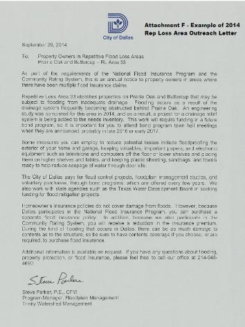
33 501 THE REPETITIVE LOSS LIST OBJECT: TRACKING PROPERTIES WHICH HAVE MULTIPLE FLOOD INSURANCE CLAIMS Repetitive Loss Plan Mitigation Strategy Repetitive Loss Area Analysis Repetitive Loss Inventory Repetitive Loss Maps Repetitive Loss Outreach Repetitive Loss Areas 1-44
 Step 1: Organize to prepare the plan Step 2: Involve the public Step 3: Coordinate Step 4: Assess the hazard Step 5: Assess")
 2D Analysis on four Repetition Loss Areas Natural Floodplain Functions Plan")
34 510 FLOODPLAIN MANAGEMENT PLANNING 50 POINTS OBJECT: CREDIT OVERALL STRATEGY TO REDUCE ADVERSE IMPACT OF THE HAZARD Floodplain Management Planning (FMP) Step 1: Organize to prepare the plan Step 2: Involve the public Step 3: Coordinate Step 4: Assess the hazard Step 5: Assess the problem Step 6: Set goals Step 7: Review possible activities Step 8: Draft an action plan Step 9: Adopt the plan Step 10: Implement, evaluate, and revise Repetitive Loss Area Analysis (RLAA) 2D Analysis on four Repetition Loss Areas Natural Floodplain Functions Plan (NFP)

 Severe")
 Buildings located in the V Zone or")
35 520 ACQUSITION AND RELOCATION 105 POINTS OBJECT: CREDIT OVERALL STRATEGY TO REDUCE ADVERSE IMPACT OF THE HAZARD Buildings Acquired or Relocation (bar) Buildings on the Repetitive Loss List (brl) Severe Repetitive Loss Properties (bsrl) Critical Facilities (bcf) Buildings located in the V Zone or Coastal A Zone (bvz)

 Flood Protection Improvement (FPI) Protected")
36 530 FLOOD PROTECTION 0 POINTS OBJECT: RETROFIT BUILDINGS AND CONSTRUCT SMALL FLOOD CONTROL PROJECTS Flood Protection Project Technique Used (TU_) Flood Protection Improvement (FPI) Protected Buildings (PB)

37 540 DRAINAGE SYSTEM MAINTENANCE 265 POINTS OBJECT: KEEP CHANNELS AND STORAGE BASIN CLEAR OF DEBRIS Chanel Debris Removal (CDR)

38 540 DRAINAGE SYSTEM MAINTENANCE 265 POINTS OBJECT: KEEP CHANNELS AND STORAGE BASIN CLEAR OF DEBRIS Problem Site Maintenance (PSM) Keep list of problem sites, inspect and maintain annually. Capital Improvement Program (CIP) Bond program/needs Inventory Stream Dumping Regulations (SDR) Storage Basin Maintenance (SBM) Coastal Erosion Protection Maintenance (EPM)
39 600 SERIES 610 Flood Warning and Response 620 Levees 630 Dams
40 610 FLOOD WARNING AND RESPONSE 0 POINTS OBJECT: IDENTIFY FLOOD THREAT, DISSEMINATE WARNINGS, FLOOD RESPONSE ACTIVITIES Flood Threat Recognition System (FTR) Manual flood threat recognition systems Correlated to the flood inundation map Emergency Warning Dissemination (EWD) Flood Warning Sirens Flood Response Operations (FRO) Action list at different flood levels Critical Facilities Planning (CFP) Include Critical Facilities in Warning/Response Plan StormReady Community (SRC) TsunamiReady Community (TRC)
41 620 LEVEES 0 POINTS OBJECT: INSPECT AND MAINTAIN LEVEES, IDENTIFY FAILURE, DISSEMINTATE WARNINGS, RESPONSE Levee Maintenance (LM) Levee Emergency Action Plan and Operations Manual Annual Inspections Levee Failure Threat Recognition System (LFR) Monitoring Flood/Levee Conditions Levee Failure Warning (LFW) Warning Program Levee Failure Response Operations (LFO) Levee failure response plan Levee Failure Critical Facilities Planning (LCF) List of Facilities with names and numbers of operators
42 620 DAMS 22 POINTS OBJECT: INSPECT AND MAINTAIN DAMS, IDENTIFY FAILURE, DISSEMINTATE WARNINGS, RESPONSE State Dam Safety Program (SDS) City has ten high hazard dams Dam Failure Threat Recognition System (DFR) Primary/Secondary threat recognition Dam Failure Warning (DFW) Warning Program Dam Failure Response Operations (DFO) Dam Emergency Action Plan Dam Failure Critical Facilities Planning (DCF) List of Facilities with names and numbers of operators
43 700 SERIES 710 County Growth Adjustments 720 Community Total Points
44 710 COUNTY GROWTH ADJUSTMENT 22 POINTS OBJECT: INCREASE CREDIT FOR MANAGING ACTIVITIES IN GROWING AREAS County 10-Year Growth Rate (CGR) Annual Growth Adjustment (AGA) CGR converted to an annual growth rate County Growth Adjustment (CGA) CGA is ten times the annual growth rate Dallas County has a CGA of 1.15 Credit for 400 series multiplied by CGA


45 720 TOTAL POINTS OBJECT: ASSIGN CRS CLASITIFCATION BASED ON SUM OF ALL ACTIVITIES
46 DALLAS NEXT STEP DRIVE TO CLASS 4 Class 4 Prerequisites The community must have received and continue to maintain a classification of 4/4 or better under the BCEGS. Activity 430 (Higher Regulatory Standards) At least 100 points for FBR At least 700 points under other elements of 430 and under 422 a, e, f and under Activity 420 Activity 450 (Stormwater Management) 90 points for meeting all criteria for WMP 30 points for managing the runoff for all storms up to and including the 100-year event Impact adjustment value of rwmp=0.5 or more. Activity 510 (Floodplain Management Planning) Receive at least 50% of maximum credit under 510 Obtain a minimum of 100 points from 420, 450, 510 Obtain some credit under Activity 610 (Flood Warning and Response)
47 DALLAS NEXT STEP DRIVE TO CLASS 4 Class 4 Prerequisites The community must have received and continue to maintain a classification of 4/4 or better under the BCEGS. Activity 430 (Higher Regulatory Standards) At least 100 points for FBR At least 700 points under other elements of 430 and under 422 a, e, f and under Activity 420 Activity 450 (Stormwater Management) 90 points for meeting all criteria for WMP 30 points for managing the runoff for all storms up to and including the 100-year event Impact adjustment value of rwmp=0.5 or more. Activity 510 (Floodplain Management Planning) Receive at least 50% of maximum credit under 510 Obtain a minimum of 100 points from 420, 450, 510 Obtain some credit under Activity 610 (Flood Warning and Response)
48 Questions? Steve Parker, PE, CFM City of Dallas Jack Young, PE, CFM Halff Associates Sirak Bahta, PE City of Dallas
CRS UNIFORM MINIMUM CREDIT CALIFORNIA
 CRS UNIFORM MINIMUM CREDIT CALIFORNIA SUMMARY The Community Rating System (CRS) provides Uniform Minimum Credit (UMC) for certain state laws, regulations, and standards that support floodplain management
CRS UNIFORM MINIMUM CREDIT NEW JERSEY
 CRS UNIFORM MINIMUM CREDIT NEW JERSEY SUMMARY The Community Rating System (CRS) provides Uniform Minimum Credit (UMC) for certain state laws, regulations, and standards that support floodplain management
Chehalis River Basin Basin-Wide Floodplain Management Assessment
 Chehalis River Basin Basin-Wide Floodplain Management Assessment November 30, 2014 French & Associates, LTD. 2601 Havelock Court Steilacoom, WA 98388 Chehalis River Basin Basin-Wide Floodplain Management
CITY OF PLANTATION ENGINEERING DEPARTMENT INTEROFFICE MEMORANDUM NO
 CITY OF PLANTATION ENGINEERING DEPARTMENT INTEROFFICE MEMORANDUM NO. 2013-003 DATE: October 22, 2012 TO: Mayor and Members of City Council FROM: Brett W. Butler, PE, CFM City Engineer SUBJECT: CRS Program
CRS UNIFORM MINIMUM CREDIT NORTH CAROLINA
 CRS UNIFORM MINIMUM CREDIT NORTH CAROLINA SUMMARY The Community Rating System (CRS) provides Uniform Minimum Credit (UMC) for certain state laws, regulations, and standards that support floodplain management
Community Rating System. National Flood Insurance Program
 National Flood Insurance Program Community Rating System A Local Official s Guide to Saving Lives Preventing Property Damage Reducing the Cost of Flood Insurance FEMA B-573 / May 2015 How the Community
CRS 2013: New Activities, New Opportunities. What Is CRS? How To Join Changes from Outreach Projects 430 Higher Regulatory Standards
 CRS 2013: New Activities, New Opportunities What Is CRS? How To Join Changes from 2007 2013 330 Outreach Projects 430 Higher Regulatory Standards What Is CRS? Voluntary Program under the NFIP Community
Appendix B. A Comparison of the Minimum NFIP Requirements and the CRS
 A Comparison of the Minimum s and the CRS The Community Rating System provides credits for exceeding the minimum requirements of the National Flood Insurance Program (NFIP). Many local officials are not
COMMUNITY RATING SYSTEM (CRS) October 28, 2013
 October 28, 2013") COMMUNITY RATING SYSTEM (CRS) October 28, 2013 SUE K. HOPFENSPERGER, CFM ISO/CRS SPECIALIST ASSOCIATION OF STATE FLOODPLAIN MANAGER CERTIFIED FLOODPLAIN MANAGER Location: Fernandina Beach, FL INSURANCE
COMMUNITY RATING SYSTEM (CRS) October 28, 2013 SUE K. HOPFENSPERGER, CFM ISO/CRS SPECIALIST ASSOCIATION OF STATE FLOODPLAIN MANAGER CERTIFIED FLOODPLAIN MANAGER Location: Fernandina Beach, FL INSURANCE
Floodplain Management Plan
 Floodplain Management Plan CITY OF FORT WORTH TFMA 2016 Spring Conference March 10, 2016 Agenda 1. Fort Worth Higher Standards (NFIP & CRS) 2. Floodplain Management Plan Overview and Results 3. Project
Flooding. Frequent occurrence. Can be severe and result in significant property damage. Major risk
 Welcome Flooding Frequent occurrence Can be severe and result in significant property damage Major risk NATURAL HAZARD MITIGATION PLAN UPDATES - CAPITOL REGION Presenters: Christopher Markesich, FEMA CRS
National Flood Insurance Program (NFIP) Community Rating System (CRS) Together North Jersey Resilient Task Force Meeting
 Community Rating System (CRS) Together North Jersey Resilient Task Force Meeting") National Flood Insurance Program (NFIP) Community Rating System (CRS) Together North Jersey Resilient Task Force Meeting April 3, 2017 Marianne Luhrs, AICP FEMA R2 CRS Coordinator Visual Intro-1 CRS Program
National Flood Insurance Program (NFIP) Community Rating System (CRS) Together North Jersey Resilient Task Force Meeting April 3, 2017 Marianne Luhrs, AICP FEMA R2 CRS Coordinator Visual Intro-1 CRS Program
10/5/2015. What Makes a Sound Floodplain Management Program? What are the Flood Problems in your Community?
 The Community Rating System (CRS) and Hazard Mitigation Planning Preparing Your Community Through Common Program Goals September 3, 2015 What Makes a Sound Floodplain Management Program? Know your community
Land Economics 94:2, May 2018 Flood Risk, Local Hazard Mitigation, and the Community Rating System of NFIP, by Jingyuan Li and Craig E.
 APPENDIX Table A1. Community Rating System Activities and Credit Scores Series Description Creditable Activities Points 1. Elevation Certificates 162 Public Information (300) CRS will credit those local
Appendix 1 Kick off meeting
 Appendix 1 Kick off meeting WEST COG o o Regional CRS Kick Off Meeting Notes Intro Info Towns must receive 500 points in order to receive 5% discount on insurance premiums. Each town will have their own
Leveraging the Community Rating System for Climate Adaptation. Southeast and Caribbean Climate Community of Practice Webinar Series 23 March 2015
 Leveraging the Community Rating System for Climate Adaptation Southeast and Caribbean Climate Community of Practice Webinar Series 23 March 2015 Today s Speakers: Shana Jones, J.D., Carl Vinson Institute
Action Items for Flood Risk Management on Wildcat Creek Interagency success with floodplain management plans and flood forecast inundation maps
 Presentation to USACE 2012 Flood Risk Management and Silver Jackets Joint Workshop, Harrisburg, Pennsylvania Action Items for Flood Risk Management on Wildcat Creek Interagency success with floodplain
Floodplain Management Assessment
 CHEHALIS RIVER BASIN Floodplain Management Assessment Master Report Final April, 2015 TABLE OF CONTENTS Executive Summary... 1 Introduction... 2 The Floodplain... 4 Floodplain Development... 4 Floodplain
Natural Hazards Mitigation Plan Kankakee County, Illinois Executive Summary
 1. Introduction Natural Hazards Mitigation Plan Kankakee County, Illinois Executive Summary Kankakee County is subject to natural hazards that threaten life, safety, health, and welfare and cause extensive
CRS State Profile: Wyoming
 CRS State Profile: Wyoming This is a profile for communities in your state that are participating in the Community Rating System (CRS). This profile is intended to provide information to the State NFIP
ASFPM Partnerships for Statewide Mitigation Actions. Alicia Williams GIS and HMP Section Manager, Amec Foster Wheeler June 2016
 ASFPM Partnerships for Statewide Mitigation Actions Alicia Williams GIS and HMP Section Manager, Amec Foster Wheeler June 2016 Summary The Concept Leveraging Existing Data and Partnerships to reduce risk
Thurston County, WA Flood Hazard Mitigation Plan Annual Progress Report CRS Activity 510
 Thurston County, WA Flood Hazard Mitigation Plan Annual Progress Report CRS Activity 510 Reporting Period: ctober 1, 2014 to September 30, 2015 Background: Thurston County developed a flood hazard mitigation
Bucks County, PA Flood Risk Review Meeting. November 2014
 Bucks County, PA Flood Risk Review Meeting November 2014 Agenda for Today Risk MAP Program overview Overview of non-regulatory Flood Risk Products and datasets Discuss mitigation action Technical overview
This survey is expected to take approximately 20 minutes and must be completed in one session.
 State Flood Assessment Survey 1 Introduction Thank you for your willingness to participate in this online survey as part of the State Flood Assessment effort. This first step toward developing comprehensive
370 Flood Insurance Promotion. 370 Flood Insurance Promotion
 370 Flood Insurance Promotion Visual 320.1 Visual 370-1 Manual Page 370-2 The simple truth is that residents and business owners with adequate flood insurance rebuild and recover faster and return to normal
Section 19: Basin-Wide Mitigation Action Plans
 Section 19: Basin-Wide Mitigation Action Plans Contents Introduction...19-1 Texas Colorado River Floodplain Coalition Mitigation Actions...19-2 Mitigation Actions...19-9 Introduction This Mitigation Plan,
Erie County Flood Risk Review Meeting. January 18, 2018
 Erie County Flood Risk Review Meeting January 18, 2018 Agenda The value of updated flood maps for your community Review updated flood-risk data and important next steps in the Risk MAP process Increasing
Floodplain Management and Florida s Initiatives for Resiliency
 Floodplain Management and Florida s Initiatives for Resiliency Steve Martin, CFM, State NFIP Coordinator THE WAY FORWARD IN FLORIDA NFIP key elements: Insurance, Mapping, Regulations & Mitigation CRS improves
Natural Hazards Mitigation Plan. Executive Summary
 Natural Hazards Mitigation Plan Executive Summary 1. Introduction Kane County Illinois, is subject to natural hazards that threaten life and health and have caused extensive property damage. Floods struck
FEMA FLOOD MAPS Public Works Department Stormwater Management Division March 6, 2018
 FEMA FLOOD MAPS Public Works Department Stormwater Management Division March 6, 2018 Presentation Overview FEMA National Flood Insurance Program (NFIP) FEMA Community Rating System (CRS) Flood Insurance
This survey is expected to take approximately 20 minutes and must be completed in one session.
 Introduction Thank you for your willingness to participate in this online survey as part of the State Flood Assessment effort. This first step toward developing comprehensive flood planning for Texas does
Changes in Criteria and Scoring for CRS Outreach Projects
 Changes in Criteria and Scoring for CRS Outreach Projects A Handout for the National Flood Insurance Program Community Rating System Many communities want to keep disseminating and obtaining CRS credit
SECTION V THE LOCAL MITIGATION STRATEGY BLUEPRINT
 SECTION V THE LOCAL MITIGATION STRATEGY BLUEPRINT A. GUIDING MITIGATION PRINCIPLES The Local Mitigation Strategy (LMS) is Hillsborough County s program developed to reduce or eliminate all forms of losses
King County Flood Control District 2015 Work Program
 Attachment A 2015 Work Plan 10-24-14 King County Flood Control District 2015 Work Program The District work program is comprised of three categories: district oversight and policy development, operations,
REAL ESTATE FLOOD DISCLOSURE PROGRAM & FLOOD MAP INFORMATION SERVICES
 REAL ESTATE FLOOD DISCLOSURE PROGRAM & FLOOD MAP INFORMATION SERVICES Lisa Foster, CFM, Floodplain Coordinator ldfoster@pinellascounty.org January 26, 2018 Why are you here? Save your clients money on
CRS State Profile: Alaska
 CRS State Profile: Alaska This is a profile for communities in your state that are participating in the Community Rating System (CRS). This profile is intended to provide information to the State NFIP
Non Regulatory Risk MAP Products Flood Depth and Probability Grids
 Non Regulatory Risk MAP Products Flood Depth and Probability Grids Virginia Floodplain Management Association 2015 Floodplain Management Workshop October 29th, 2015 Nabil Ghalayini, P.E., PMP, D.WRE, CFM
Floodplain Management 101. Mississippi Emergency Management Agency Floodplain Management Bureau
 Floodplain Management 101 Mississippi Emergency Management Agency Floodplain Management Bureau Stafford Act The Stafford Disaster Relief and Emergency Assistance Act (Stafford Act) (Public Law 100-707)
FLOODPLAIN MANAGEMENT PLAN 2015 ANNUAL PROGRESS REPORT
 FLOODPLAIN MANAGEMENT PLAN 2015 ANNUAL PROGRESS REPORT Hinds County (Unincorporated) NFIP Community Number 280070 The 2015 Floodplain Management Plan Annual Progress Report on the progress made in implementing
Planning Process---Requirement 201.6(b): An open public involvement process is essential to the development of an effective plan.
: An open public involvement process is essential to the development of an effective plan.") Section 3 Capability Identification Requirements Planning Process---Requirement 201.6(b): An open public involvement process is essential to the development of an effective plan. Documentation of the Planning
Section 3 Capability Identification Requirements Planning Process---Requirement 201.6(b): An open public involvement process is essential to the development of an effective plan. Documentation of the Planning
State of South Carolina Five-Year Floodplain Management Work Plan
 Purpose The purpose of the Community Assistance Program State Support Services Element (CAP-SSSE) is to provide, through a State grant mechanism, a means to ensure that communities participating in the
Attachment B. King County Flood Control Zone District Work Program
 Attachment B King County Flood Control Zone District Work Program The King County Flood Control Zone District work program is comprised of two major categories: Programmatic Work Program o Flood Preparedness,
HAZARD MITIGATION PLAN POINT OF CONTACT MUNICIPAL PROFILE
 HAZARD MITIGATION PLAN POINT OF CONTACT louise@windgap-pa.gov jeffreyyob@gmail.com MUNICIPAL PROFILE MUNICIPAL PARTICIPATION Compliance with the National Flood Insurance Program (NFIP) Identify source
Kevin Wagner Maryland Department of the Environment
 Kevin Wagner Maryland Department of the Environment Topics Overview of the National Flood Insurance Program (NFIP) Mapping Regulations Insurance Mitigation Community Rating System (CRS) Questions Know
CRS State Profile: Connecticut
 CRS State Profile: Connecticut This is a profile for communities in your state that are participating in the Community Rating System (CRS). This profile is intended to provide information to the State
Increasing Risk Communication for Property Owners with Risk NJAFM Conference Atlantic City, NJ
 RISK COMMUNICATION Increasing Risk Communication for Property Owners with Risk MAP Products Garrett Skinner CFM Garrett Skinner, CFM 2014 NJAFM Conference Atlantic City, NJ Overview Background Flood Risk
HOW PLANNING FOR SEA LEVEL RISE CREATES FLOOD INSURANCE REDUCTIONS: THE GEORGIA CONTEXT. Hunter Jones 1 I. INTRODUCTION
 HOW PLANNING FOR SEA LEVEL RISE CREATES FLOOD INSURANCE REDUCTIONS: THE GEORGIA CONTEXT Hunter Jones 1 I. INTRODUCTION Flood insurance rates are rising for homeowners. One way local governments can create
Use of FEMA Non regulatory Flood Risk Products in Planning
 Use of FEMA Non regulatory Flood Risk Products in Planning Georgia Association of Floodplain Managers Annual Conference March 24, 2016 What are the Non regulatory Flood Risk products? Go beyond the basic
Findings/Debrief Meeting September 9, CDOT R4 Headquarters Big Thompson Conference Room W 10 th St. Greeley, CO 80634
 Findings/Debrief Meeting September 9, 2016 CDOT R4 Headquarters Big Thompson Conference Room 10601 W 10 th St. Greeley, CO 80634 Discovery Review & Outcome May 25 Discovery Meeting Summary Summarize Data
A Flood Mitigation Plan for the Non-Tidal N.J. Section of the Delaware River Basin. Warren County Planning Workshop (2 nd Meeting) March 7, 2007
 March 7, 2007") A Flood Mitigation Plan for the Non-Tidal N.J. Section of the Delaware River Basin Warren County Planning Workshop (2 nd Meeting) March 7, 2007 Study Area Participation: Hunterdon: 16 Eligible Municipalities
A Flood Mitigation Plan for the Non-Tidal N.J. Section of the Delaware River Basin Warren County Planning Workshop (2 nd Meeting) March 7, 2007 Study Area Participation: Hunterdon: 16 Eligible Municipalities
Modernization, FEMA is Recognizing the connection between damage reduction and
 EXECUTIVE SUMMARY Every year, devastating floods impact the Nation by taking lives and damaging homes, businesses, public infrastructure, and other property. This damage could be reduced significantly
COMMUNITY CERTIFICATIONS
 OMB No. xxxxxxxx Expires: xxxxxxxx National Flood Insurance Program Community Rating System COMMUNITY CERTIFICATIONS D R A F T CRS COMMUNITY CERTIFICATIONS The following community certifications are part
Role of Disaster Insurance in Improving Resilience: An Expert Meeting The Resilient America Roundtable
 Role of Disaster Insurance in Improving Resilience: An Expert Meeting The Resilient America Roundtable National Academy of Science Washington, DC July 9, 2015 Roseville Demographics Primary population
Crediting Adaptation Strategies through the National Flood Insurance Program s Community Rating System Coordinator s Manual
 Crediting Adaptation Strategies through the National Flood Insurance Program s Community Rating System Coordinator s Manual W. Thomas Hawkins, Adjunct Faculty, University of Florida, Levin College of Law
Cameron County, TX. Consultation Coordination Officer (CCO) Meeting. Please sign in (sheet at front of the room) Meeting will begin at 9:00
 Meeting. Please sign in (sheet at front of the room) Meeting will begin at 9:00") Cameron County, TX Consultation Coordination Officer (CCO) Meeting Please sign in (sheet at front of the room) Meeting will begin at 9:00 July 29, 2015 Lisa Jennings FEMA Region 6 Roles & Responsibilities
Cameron County, TX Consultation Coordination Officer (CCO) Meeting Please sign in (sheet at front of the room) Meeting will begin at 9:00 July 29, 2015 Lisa Jennings FEMA Region 6 Roles & Responsibilities
CRS State Profile: Ohio
 CRS State Profile: Ohio This is a profile for communities in your state that are participating in the Community Rating System (CRS). This profile is intended to provide information to the State NFIP Coordinator
Flood Plain Management Services (FPMS) Program
 Program") Flood Plain Management Services (FPMS) Program 2016 Winter Stakeholder Partnering Forum March 2016 Mario Beddingfield, P.E., CFM Hydraulic Engineer/FPMS Program Manager H&H/Water Control Branch U.S. Army
Flood Plain Management Services (FPMS) Program 2016 Winter Stakeholder Partnering Forum March 2016 Mario Beddingfield, P.E., CFM Hydraulic Engineer/FPMS Program Manager H&H/Water Control Branch U.S. Army
Outreach Projects. for Credit under the Community Rating System of the National Flood Insurance Program
 Outreach Projects for Credit under the Community Rating System of the National Flood Insurance Program 2017 CONTENTS Introduction...1 Step 1. Determine your Audiences...2 Step 2. Draft your Messages...4
Planning Process---Requirement 201.6(b): An open public involvement process is essential to the development of an effective plan.
: An open public involvement process is essential to the development of an effective plan.") Section 3 Capability Identification Requirements Planning Process---Requirement 201.6(b): An open public involvement process is essential to the development of an effective plan. Documentation of the Planning
Section 3 Capability Identification Requirements Planning Process---Requirement 201.6(b): An open public involvement process is essential to the development of an effective plan. Documentation of the Planning
Flood Risk Products. New Techniques for Identifying and Communicating Flood Risk
 Flood Risk Products New Techniques for Identifying and Communicating Flood Risk Mark Zito, GISP, CFM GIS Specialist Amol Daxikar, GISP, CFM Project Manager March 28, 2012 1% Flood with 3 Feet Sea Level
Chapter 7 Appendix B: National Flood Insurance Program Summary for Kaua'i County, 2015 Update
 Chapter 7 Appendix B: National Flood Insurance Program Summary for Kaua'i County, 2015 Update Topic Considerations Description INSURANCE SUMMARY STAFF RESOURCES How many NFIP policies are in Kaua i County?
TIPS FOR PREPARING TO JOIN SYSTEM THE COMMUNITY RATING. Kristin Owen, AICP, CFM. VFMA Fall Workshops
 TIPS FOR PREPARING TO JOIN THE COMMUNITY RATING SYSTEM Kristin Owen, AICP, CFM 1 The Community Rating System (CRS) Voluntary program for communities participating in the NFIP Recognizes activities beyond
Repetitive Loss Area Revisit # 6 Walter Road Area Jefferson Parish
 Repetitive Loss Area Revisit # 6 Walter Road Area Jefferson Parish www.floodhelp.uno.edu Supported by FEMA Acknowledgement The compilation if this report was managed by Erin Patton, CFM, a UNO-CHART Research
Volusia County Floodplain Management Plan 2012
 Volusia County Floodplain Management Plan 2012 Introduction The National Flood Insurance Program (NFIP) provides federally supported flood insurance in communities that regulate development in floodplains.
Taylor County, Florida Community Coordination and Outreach (CCO) Meeting
 Meeting") Taylor County, Florida Community Coordination and Outreach (CCO) Meeting Suwannee River Water Management District April 26, 2017 11:00AM to 12:00PM Taylor County Administration Building, 201 E. Green Street,
Taylor County, Florida Community Coordination and Outreach (CCO) Meeting Suwannee River Water Management District April 26, 2017 11:00AM to 12:00PM Taylor County Administration Building, 201 E. Green Street,
Updates to Maine Coastal Flood Insurance Rate Maps (FIRM s): What a Local Official Should Know. Presented by: Steve Johnson, P.E.
: What a Local Official Should Know. Presented by: Steve Johnson, P.E.") Updates to Maine Coastal Flood Insurance Rate Maps (FIRM s): What a Local Official Should Know Presented by: Steve Johnson, P.E. Town Engineer October 4, 2018 Introduction Federal Emergency Management
Updates to Maine Coastal Flood Insurance Rate Maps (FIRM s): What a Local Official Should Know Presented by: Steve Johnson, P.E. Town Engineer October 4, 2018 Introduction Federal Emergency Management
Maryland Model Floodplain Management Ordinance (May, 2014) MODEL NOTES
 MODEL NOTES") Maryland Model Floodplain Management Ordinance (May, 2014) MODEL NOTES The model floodplain management ordinance that most Maryland communities have used as the basis for their regulations since the early
Maryland Model Floodplain Management Ordinance (May, 2014) MODEL NOTES The model floodplain management ordinance that most Maryland communities have used as the basis for their regulations since the early
California Building Code and the NFIP. John Ingargiola, Senior Engineer FEMA Building Science Branch
 California Building Code and the NFIP John Ingargiola, Senior Engineer FEMA Building Science Branch CA Major Disaster Declarations and Federal Assistance $21 $21 $76 $78 7 declarations, 2004-2016, total
CRS State Profile: Massachusetts
 CRS State Profile: Massachusetts This is a profile for communities in your state that are participating in the Community Rating System (CRS). This profile is intended to provide information to the State
Michael Taylor, PE, CFM Project Manager, AECOM August 25, 2015
 Promoting FEMA s Flood Risk Products in the Lower Levisa Watershed Michael Taylor, PE, CFM Project Manager, AECOM August 25, 2015 Agenda Study Background Flood Risk Product Overview AOMI and Mitigation
The National Flood Insurance Program Community Rating System: An Introduction and Discussion of the RDO Role. October 2, :00-3:15 pm ET
 The National Flood Insurance Program Community Rating System: An Introduction and Discussion of the RDO Role October 2, 2014 2:00-3:15 pm ET Our Mission The National Association of Development Organizations
MUNICIPAL LAND USE STRATEGIES for Improving Flood Resilience
 MUNICIPAL LAND USE STRATEGIES for Improving Flood Resilience Strategy for a Flood Resistant Southern Tier Central Region (LWRP project) This presentation was prepared by Southern Tier Central Regional
David A. Stroud, CFM AMEC Earth & Environmental Raleigh, NC
 David A. Stroud, CFM AMEC Earth & Environmental Raleigh, NC Objectives Risk MAP background North Carolina s Risk MAP role Role of communication in Risk MAP Effective risk communication two examples Multi-hazard
ROI for Joining CRS. Floodplain Management Association Conference. Sacramento, CA. September 2016
 ROI for Joining CRS Floodplain Management Association Conference Sacramento, CA September 2016 Agenda Joining CRS Challenges ROI Tips Wrap Up 1 FMA Conference What is CRS? Community Rating System Voluntary
SECTION 9: MAPS AND DATA
 SECTION 9: MAPS AND DATA Contents 9.1. NFIP Maps and Data... 9-2 9.1.1. Adopting and enforcing NFIP floodplain maps and data... 9-2 9.1.2. Adopting and enforcing more restrictive data... 9-2 9.1.3. Annexations...
Welcome to a Silver Jackets Webinar
 Welcome to a Silver Jackets Webinar The CRS and Repetitive Loss Area Analysis (RLAA) For audio, Dial: 877 336-1839 Access code: 5884527 Security code: 4567 Visual 10.1 David A. Stroud, CFM Emergency &
HAZARD MITIGATION PLAN POINT OF CONTACT MUNICIPAL PROFILE
 HAZARD MITIGATION PLAN POINT OF CONTACT stockpolice@rcn.com stockworks@rcn.com MUNICIPAL PROFILE MUNICIPAL PARTICIPATION Compliance with the National Flood Insurance Program (NFIP) Identify source of information,
Durham County Preliminary Flood Hazard Data Public Meeting. July 28, 2016
 Durham County Preliminary Flood Hazard Data Public Meeting July 28, 2016 Why Are We Here New flood hazard data has been released as Preliminary for Durham County Statutory Due Process for review/comments
CRS State Profile: Indiana
 CRS State Profile: Indiana This is a profile for communities in your state that are participating in the Community Rating System (CRS). This profile is intended to provide information to the State NFIP
FREQUENTLY ASKED QUESTION ABOUT FLOODPLAINS Michigan Department of Environmental Quality
 FREQUENTLY ASKED QUESTION ABOUT FLOODPLAINS Michigan Department of Environmental Quality WHAT IS A FLOOD? The National Flood Insurance Program defines a flood as a general and temporary condition of partial
BACKGROUND ANNUAL PROGRESS REPORT DEVELOPMENT ADOPTION OF THE H-GAC HAZARD MITIGATION PLAN/UPDATES MISSION STATEMENT
 BACKGROUND CITY OF CONROE FLOODPLAIN MANAGEMENT ANNUAL PROGRESS Activity 510 of the National Flood Insurance Program s (NFIP) Community Rating System (CRS) requires the development of a Floodplain Management
Best Practices. for Incorporating Building Science Guidance into Community Risk MAP Implementation November 2012
 Best Practices for Incorporating Building Science Guidance into Community Risk MAP Implementation November 2012 Federal Emergency Management Agency Department of Homeland Security 500 C Street, SW Washington,
Flood Risk Outreach Tools for Georgia Communities. GAFM 10 th Annual Conference Presented By: Jarrett Mattli
 Flood Risk Outreach Tools for Georgia Communities GAFM 10 th Annual Conference Presented By: Jarrett Mattli April 13, 2016 Presentation Overview Guidebooks Toolkits Templates Educational Videos Resource
HAZARD MITIGATION PLAN POINT OF CONTACT MUNICIPAL PROFILE
 HAZARD MITIGATION PLAN POINT OF CONTACT glendonboro@rcn.com glendonboro@rcn.com MUNICIPAL PROFILE MUNICIPAL PARTICIPATION Identify source of information, if different Topic from the one listed 1. Staff
AMENDMENTS TO CHAPTER 50: FLOODPLAIN DEVELOPMENT
 AMENDMENTS TO CHAPTER 50: FLOODPLAIN DEVELOPMENT PART I: 2018 FLOOD MAP IMPLEMENTATION PART II: STRATEGIES TO IMPROVE THE CITY S COMMUNITY RATING SYSTEM SCORE NATIONAL FLOOD INSURANCE PROGRAM (NFIP) CREATED
Chapter 6 - Floodplains
 Chapter 6 - Floodplains 6.1 Overview The goal of floodplain management is to reduce the potential risks to both existing and future developments, and infrastructure, in the 100-year floodplain. Over the
AGENDA. Floodplain Manager s Toolkit Unlocking the Hidden Potential of Floodplain Data for Your Community
 Floodplain Manager s Toolkit Unlocking the Hidden Potential of Floodplain Data for Your Community TFMA Spring Conference May 29, 2014 Jessica D. Baker, PE, CFM, PMP Samuel Amoako-Atta, GISP, CFM Eric Hajek,
Floodplain Manager s Toolkit Unlocking the Hidden Potential of Floodplain Data for Your Community
 Floodplain Manager s Toolkit Unlocking the Hidden Potential of Floodplain Data for Your Community TFMA South Central Lunch Event San Antonio, TX June 12, 2014 Jessica D. Baker, PE, CFM, PMP Samuel Amoako-Atta,
Pre-Development Floodplain Application
 Pre-Development Floodplain Application The Department of Planning, at the recommendation of FEMA, is now requiring completion of a Pre- Development Floodplain Application for all properties in the regulated
Using GISWeb to Determine Your Property s Flood Zone
 Using GISWeb to Determine Your Property s Flood Zone 1. In a new browser window, go to http://www.co.santacruz.ca.us/departments/geographicinformationsystemsgis.aspx 2. Click on GISWeb - GIS Mapping Application
HAZARD MITIGATION PLAN POINT OF CONTACT MUNICIPAL PROFILE
 HAZARD MITIGATION PLAN POINT OF CONTACT nazareth50em1@gmail.com jessicagteel@gmail.com MUNICIPAL PROFILE MUNICIPAL PARTICIPATION 3. Describe how the public will be engaged in the current planning process
Table 1: Federal, State and Local Government Rules applicable to LOMRs/CLOMRS submittal
 MnDNR LOMC Guide This document has been prepared by the Minnesota Department of Natural Resources floodplain staff and is intended to provide assistance with LOMR/CLOMR submittals. This information is
HAZARD MITIGATION PLAN POINT OF CONTACT. MUNICIPAL PROFILE
 HAZARD MITIGATION PLAN POINT OF CONTACT alacko@walnutportpa.org MUNICIPAL PROFILE MUNICIPAL PARTICIPATION Compliance with the National Flood Insurance Program (NFIP) Topic 1. Staff Resources Is the Community
RichSmith_slate-FEMA_320x240.wmv.
 Nebraska DNR s role in the making of FEMA s Digital Flood Insurance Rate Maps Becky Groshens (grow-hands) & Shelley Schindler Important Terms: FIRM: Flood Insurance Rate Map FIS: Flood Insurance Study
Enough about me! Topics Covered
 About Me Worked in land surveying since 1997 Employed by the City of Orlando since 2006 City of Orlando City Surveyor since February 2015 Certified Floodplain Manager since 2015 Florida Licensed Surveyor,
NFIP Mapping Issues. Wendy Lathrop, PLS, CFM. Cadastral Consulting, LLC
 NFIP Mapping Issues Cadastral Consulting, LLC NFIP Basic Objectives: Reduce the exposure to flood damages through the use of minimum standards for the placement and design of structures located in flood
Door County Floodplain Program Informational Meeting
 Door County Floodplain Program Informational Meeting Door County Land Use Services Department Wisconsin Department of Natural Resources January 15, 2018 Floodplain = Land affected by flood event with a
NFIP Program Basics. KAMM Regional Training
 NFIP Program Basics KAMM Regional Training Floodplain 101 Homeowners insurance does not cover flood damage Approximately 25,000 flood insurance policies in KY According to BW12 analysis, approximately
HAZARD MITIGATION PLAN POINT OF CONTACT MUNICIPAL PROFILE
 HAZARD MITIGATION PLAN POINT OF CONTACT hankvb@entermail.net khorvath@kceinc.com MUNICIPAL PROFILE MUNICIPAL PARTICIPATION Compliance with the National Flood Insurance Program (NFIP) Topic 1. Staff Resources
Upper Joachim Creek Public Survey on Potential Flood Risk Reduction
 Upper Joachim Creek Public Survey on Potential Flood Risk Reduction This survey is intended to help the interagency planning committee to receive public feedback on specific flood risk reduction techniques,