Flooding in Brisbane. Challenges and implications. Kerry Doss Manager City Planning & Economic Development
|
|
|
- Buddy Pearson
- 6 years ago
- Views:
Transcription

1 Flooding in Brisbane Challenges and implications Kerry Doss Manager City Planning & Economic Development
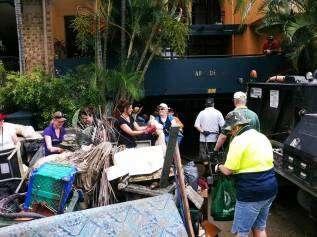
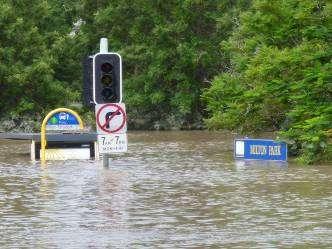
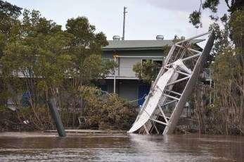
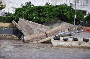
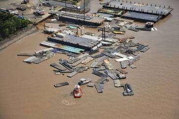
2 Brisbane, the River City In January 2011, the River City was reminded just what that meant Over 4 days Brisbane suffered it s worst flooding since 1974
3


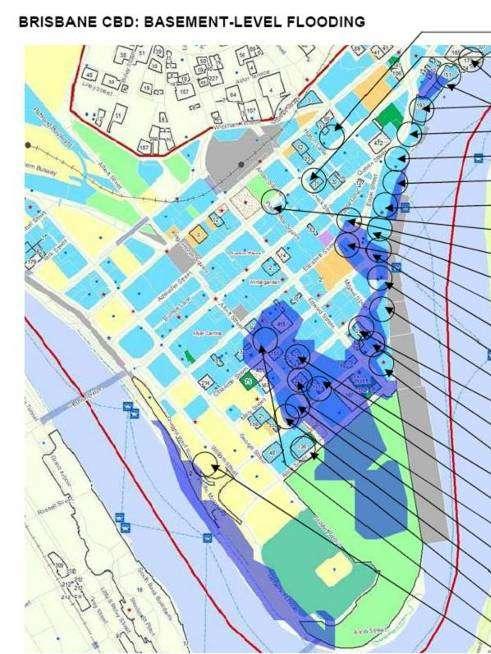
4 Impacts 35 suburbs affected majority were older suburbs pre 1960s Over 20,000 dwellings affected Isolation of units Basements flooded Critical land uses isolated Critical infrastructure damaged
5 Impacts Number of registered residential pontoons in the river pre-flood: 704. Post flood: 232 1,811 development applications for houses, apartments and commercial or industrial developments were approved in the flooded area since ,791 pre-1946 or character buildings were located in the flooded area 128 restaurants or food shops were affected by flooding Brisbane landfill received about 2/3 of its normal yearly quota from flood waste
6


7 Depth Jan 2011
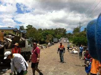
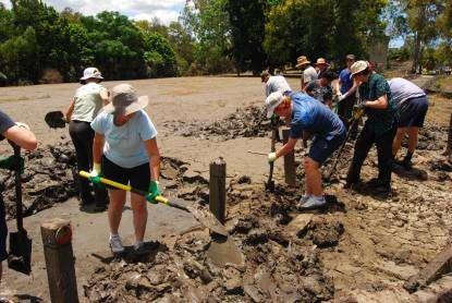
8 Council s Response Council led Community Response Instant Planning response within the legislative constraints replacement of pontoons pre-lodgements fees Interim uses Fact sheets Information to community Working with DERM and QRA TLPI
9
10 Looking backwards to go forwards
11 A history of flooding Jan 2011
12 Chronology of Town Planning Flood Controls Planning controls in Brisbane are intended to protect personal safety as a first priority and then to minimise property damage BCC has regulated development in floodable areas since 1965
13 Chronology of Town Planning Flood Controls 1965 Town Plan The 1965 Town Plan included Drainage Problem Areas declared by resolution and mapped as an appendix because land: (a) is so low-lying; or (b) is so affected, whether frequently or infrequently, by floods; or (c) is, or forms part of an area which is so difficult or expensive to drain By 1978, 54 plans had been adopted. These maps did not relate specifically to river flooding Town Plan The 1978 Town Plan introduced two new maps Areas Subject to Flooding. Designated areas affected by 1974 floods and set minimum habitable floor level for all development. Introduced provisions relating to the maps and requiring permission from Council for various forms of development in Areas Subject to Flooding. The Brisbane River Floods Restriction on Residential Use Policy was adopted by Council on 5th December This policy introduced the 3.7mAHD Port Office Gauge level requirement for habitable floor levels The adoption of Administrative Policy no. AP065 in October 1978 established the basis for regulating habitable floor levels in areas prone to Brisbane River Flooding through planning and building controls 1987 Town Plan Local Planning Policy adopted in 23 June 1987 required any application for consent for residential purposes to be clear of flood waters that would achieve 3.7mAHD at the Brisbane Port Office Gauge at a 1% probability of recurrence. Not all new houses required consent from Council, most were permitted development and did not require a development application.
14 Chronology of Flooding Controls 1996 Subdivision and Development Guidelines A recommendation of the Lord Mayor s Taskforce on Suburban Flooding was to strengthen and enhance land use controls to ensure no adverse impacts from flooding. This recommendation was reflected in the Subdivision and Development Guidelines Updated by Council Resolution in 2003 to include the DFL (defined flood level) as the minimum habitable floor levels for Houses and MUDS. The DFL maintained at 3.7mAHD at the Brisbane Port Office Gauge.
15 Chronology of Flooding Controls City Plan 2000 Houses All new houses in Brisbane are required to achieve compliance with the House Code which sets minimum floor levels for Brisbane River flooding at Q100 plus 500mm (habitable) and Q50 plus 300 mm (non habitable) Other Development Subdivision and Development Guidelines contains the minimum habitable and non habitable floor level requirements for all development. Stormwater Management Code - to integrate planning, design and implementation of the two distinct components of stormwater management, i.e. water quantity and water quality. Additional flooding requirements in Local Plans and other Codes, however they reflect the Subdivision and Development Guidelines. State Planning Policy 1/03 Mitigating the Adverse Impacts of Flood, Bushfire and Landslide - The local government must comply with State Planning Policy 1/03 Mitigating the Adverse Impacts of Flood, Bushfire and Landslide. The Council complies with the SPP via our adopted DFL in the Subdivision and Development Guidelines.
16 Planning Lessons DFL should always be taken seriously Building certifiers are a critical link Buildings and businesses at risk need to plan for resiliency The majority of suburbs flooded were settled more than 50, sometimes 150 years ago Since 1978 BCC s approach to dealing with flood prone land has been consistent and cautious


17 Our Options Our policy options are in four non- exclusive areas: Defend Adapt/Sacrifice Retreat Educate Policy responses will require trade-offs
18 Considerations We had a river flood in Jan 2011 but not creek flooding In early 2012 the Queensland Floods Commission of Inquiry will bring down its report New hydrographic survey and modelling of the Brisbane River is required Response is bigger than BCC Climate change????
19
20
21 Opportunity to rebuild Brisbane better Managing and understanding risk is key we live with the Brisbane River Building better starts at the top with our City s vision Making resilience mean something all the way down through development regulation and operational practice We need to apply the lessons learnt
22 Lessons we can learn about our physical and social environments Tested the City as a system to breaking point Legacy of development pre 1974 going back 150 years these are the places that experienced the greatest flooding impact The people before property principle served us well The community spirit is strong the Mud Army Cross government systems worked on the day Reinforced the physical context of the City on the floodplain We need better information to make decisions and provide advice, e.g. floor heights
23 Longer term re-learning to live with the Brisbane River We can fit the regional plan targets of 156,000 new dwellings without undue flood risk Detailed flood guidance in City Plan Critical infrastructure plan Resilient building designs Flood risk management plans Flood markers and FloodWise Property Reports Is Q100 the right response? What is the alternative?


24 The habitable floor level of this house is very close to the Defined Flood Level How to define what is an appropriate allowable height? - 10m could be excessive at the one end of a street, whilst not enough at the other When should buyback be used?

25 BCC Flood Risk Management Activity Beyond a Q100 Mentality Council assets and infrastructure Disaster Management Preparedness FWPR, Public Information & education programs Land use planning

26
27 Flood Risk Management Reduce Vulnerability Flood preparedness Flood warning & evacuation systems Flood information Resilient buildings Reduce Hazard Dams, walls, bunds, stormwater pipes, dredging Reduce Exposure Land use planning

28 Risk Based Planning Controls
29 Immediate challenges and overall growth challenges of the future Some Key Challenges: Reducing the risk need to establish the long term levels Education about living with the Brisbane River is key! January flood tested the planning assumptions Striking a new balance between reasonable risk and expectations - such as building heights for houses Capitalise on our experience of two decades of urban renewal planning for higher density A new way of looking at our river the threats and opportunities it presents


30
A Floodsmart Future Strategic Flood Risk Management in Brisbane Authors: Ellen Davidge (Brisbane City Council), Greg Rogencamp (Sinclair Knight Merz)
, Greg Rogencamp (Sinclair Knight Merz)") 53 rd Annual Floodplain Management Authorities Conference A Floodsmart Future Strategic Flood Risk Management in Brisbane Authors: Ellen Davidge (Brisbane City Council), Greg Rogencamp (Sinclair Knight
53 rd Annual Floodplain Management Authorities Conference A Floodsmart Future Strategic Flood Risk Management in Brisbane Authors: Ellen Davidge (Brisbane City Council), Greg Rogencamp (Sinclair Knight
Flood Risk. How do we manage flood risks? Built Form. Components of Flood Risk. Consequence of a flood. Chance of a flood
 Built Form Managing flood risk can be delivered through both planning scheme and non-planning scheme measures. During Summer 2010/2011 we witnessed just how well our built form performed. It was evident
State Planning Policy state interest guidance material. Natural hazards, risks and resilience Flood
 State Planning Policy state interest guidance material Natural hazards, risks and resilience Flood July 2017 The State of Queensland, July 2017. Published by the Department of Infrastructure, Local Government
The approach to managing natural hazards in this Plan is to: set out a clear regional framework for natural hazard management
 10 Natural Hazards 10.1 Scope and Background This chapter establishes an overall framework for natural hazard management under the Resource Management Act 1991 (RMA). It also sets out the division of responsibilities
P art B 4 NATURAL HAZARDS. Natural Hazards ISSUE 1. River Flooding
 4 NATURAL HAZARDS ISSUE 1 River Flooding A large part of the plains within the Timaru District is subject to some degree of flooding risk. At least part of all of the main settlements in the District and
Flood Risk and Land Use Vulnerability Guidance
 Flood Risk and Land Use Vulnerability Guidance UPS-BP-GU2a v.2 UNCONTROLLED DOCUMENT WHEN PRINTED Pag SCOTTISH ENVIRONMENT PROTECTION AGENCY Identifier: LUPS-GU24 Land Use Planning System SEPA Guidance
Frequently Asked Questions (FAQs)
") FLOODS Floods are one of the most common hazards in the United States. Flood effects can be local, impacting a neighborhood or community, or very large, affecting entire river basins and multiple states.
FLOODS Floods are one of the most common hazards in the United States. Flood effects can be local, impacting a neighborhood or community, or very large, affecting entire river basins and multiple states.
Environment Agency pre-application advice incorporating Local Flood Risk Standing Advice from East Lindsey District Council
 Environment Agency pre-application advice incorporating Local Flood Risk Standing Advice from East Lindsey District Council Version 1 UNCLASSIFIED We are the Environment Agency. We protect and improve
Flood Plain Management Services (FPMS) Program
 Program") Flood Plain Management Services (FPMS) Program 2016 Winter Stakeholder Partnering Forum March 2016 Mario Beddingfield, P.E., CFM Hydraulic Engineer/FPMS Program Manager H&H/Water Control Branch U.S. Army
Flood Plain Management Services (FPMS) Program 2016 Winter Stakeholder Partnering Forum March 2016 Mario Beddingfield, P.E., CFM Hydraulic Engineer/FPMS Program Manager H&H/Water Control Branch U.S. Army
International Real Estate Society Conference 99. Long Term Impact of Flood Affectation on Residential Property Prices
 International Real Estate Society Conference 99 Co-sponcors: Pacific Rim Real Estate Society (PRRES) Asian Real Estate Society (AsRES) Khuala Lumpur, 26-30 January 1999 Long Term Impact of Flood Affectation
Upper Joachim Creek Public Survey on Potential Flood Risk Reduction
 Upper Joachim Creek Public Survey on Potential Flood Risk Reduction This survey is intended to help the interagency planning committee to receive public feedback on specific flood risk reduction techniques,
Continuity Forum Reconstruction from the 2011 Queensland Floods
 Continuity Forum Reconstruction from the 2011 Queensland Floods Major General Richard Wilson Chair, Queensland Reconstruction Authority February 2012 Overview 1. Queensland s Summer Disasters Scale and
ANNEX B: TOWN OF BLUE RIVER
 ANNEX B: TOWN OF BLUE RIVER B.1 Community Profile Figure B.1 shows a map of the Town of Blue River and its location within Summit County. Figure B.1. Map of Blue River Summit County (Blue River) Annex
15-17 Unwins Bridge Road St Peters NSW September 2013
 Marrickville Council j:\jobs\112010\propertytagging\letter020813.docx 15-17 Unwins Bridge Road St Peters NSW 2044 18 September 2013 Review of Marrickville Council s Property Flood Tagging INTRODUCTION
Presented by: Connie Perkins, PE, CFM April 20, 2016
 Presented by: Connie Perkins, PE, CFM April 20, 2016 City of Sacramento s Flood History Need for a Comprehensive Flood Management Plan (CFMP) Overview of Sacramento s CFMP 2016 Next Steps Sacramento
Hazard Mitigation Grants. Technical Assistance Session Middlesex County, NJ December 7, 2011
 Hazard Mitigation Grants Technical Assistance Session Middlesex County, NJ December 7, 2011 Outline Purpose of Hazard Mitigation Hazard Mitigation Projects Hazard Mitigation Assistance Grant Programs Using
Strategic Flood Risk Management
 Strategic Management Duncan McLuckie (NSW Department of Infrastructure and Natural Resources) Introduction This paper discusses what is meant by strategic flood risk management, who is responsible in New
Mapping flood risk its role in improving flood resilience in England
 Mapping flood risk its role in improving flood resilience in England Catherine Wright Director of Digital and Skills Flood and Coastal Risk Management Environment Agency 6 October 2017 The Environment
Introduction. Purpose
 Table of Contents Introduction... 1 Purpose... 1 Related Projects and Programs 3 Vision... 3 Legislation and Policy Framework... 3 Target Audience... 4 Guiding Principles... 5 Governance... 6 Roles and
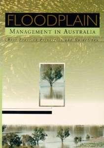
A GUIDE TO BEST PRACTICE IN FLOOD RISK MANAGEMENT IN AUSTRALIA
 A GUIDE TO BEST PRACTICE IN FLOOD RISK MANAGEMENT IN AUSTRALIA McLuckie D. For the National Flood Risk Advisory Group duncan.mcluckie@environment.nsw.gov.au Introduction Flooding is a natural phenomenon
Flood Risk Outreach Tools for Georgia Communities. GAFM 10 th Annual Conference Presented By: Jarrett Mattli
 Flood Risk Outreach Tools for Georgia Communities GAFM 10 th Annual Conference Presented By: Jarrett Mattli April 13, 2016 Presentation Overview Guidebooks Toolkits Templates Educational Videos Resource
Canada s exposure to flood risk. Who is affected, where are they located, and what is at stake
 Canada s exposure to flood risk Who is affected, where are they located, and what is at stake Why a flood model for Canada? Catastrophic losses Insurance industry Federal government Average industry CAT
INSURANCE AFFORDABILITY A MECHANISM FOR CONSISTENT INDUSTRY & GOVERNMENT COLLABORATION PROPERTY EXPOSURE & RESILIENCE PROGRAM
 INSURANCE AFFORDABILITY A MECHANISM FOR CONSISTENT INDUSTRY & GOVERNMENT COLLABORATION PROPERTY EXPOSURE & RESILIENCE PROGRAM Davies T 1, Bray S 1, Sullivan, K 2 1 Edge Environment 2 Insurance Council
Appendix A: Building our nation s resilience to natural disasters
 Appendix A: Building our nation s resilience to natural disasters In June 213, the paper, Building our Nation s Resilience to Natural Disasters, was released by Deloitte Access Economics in conjunction
A REALITY CHECK ON FLOOD RISK
 A REALITY CHECK ON FLOOD RISK Barry Carter, Nick Brown, Neil Blazey. Auckland Council, Auckland, New Zealand. ABSTRACT Traditional approaches to flood risk assessments involve modelling catchment systems
DES MOINES CITY OF TWO RIVERS. Flooding Risk & Impact to Development
 DES MOINES CITY OF TWO RIVERS Flooding Risk & Impact to Development River System Des Moines Flood Protection Des Moines Flood Protection cont. Infrastructure Over 24 miles of levees 21stormwater pump stations
Flood Management Strategy Port Phillip and Westernport
 Flood Management Strategy Port Phillip and Westernport This strategy reflects the work and expertise of floodplain managers across the region. Melbourne Water prepared this strategy with governance and
Two cases: Naga City Hangberg, Cape Town
 PMapping and PGIS for Participatory Hazard-Risk Management (CRA) M.K. McCall, ITC, Enschede Use of GIS and RS in Disaster Risk Management APDC ITC AIT Bangkok, May 2008 Two cases: Naga City Hangberg, Cape
Planning and Flood Risk
 Planning and Flood Risk Patricia Calleary BE MEngSc MSc CEng MIEI After the Beast from the East Patricia Calleary Flood Risk and Planning Flooding in Ireland» Floods are a natural and inevitable part of
HOW MUCH RISK SHOULD WE TAKE? DEVELOPING A FRAMEWORK FOR HOLISTIC RISK BASED FLOODPLAIN PLANNING
 HOW MUCH RISK SHOULD WE TAKE? DEVELOPING A FRAMEWORK FOR HOLISTIC RISK BASED FLOODPLAIN PLANNING S Molino 1, S Roso 2, G Hadzilacos 3 1 Molino Stewart Pty Ltd, Parramatta, NSW 2 Moreton Bay Regional Council,
This survey is expected to take approximately 20 minutes and must be completed in one session.
 State Flood Assessment Survey 1 Introduction Thank you for your willingness to participate in this online survey as part of the State Flood Assessment effort. This first step toward developing comprehensive
10/5/2015. What Makes a Sound Floodplain Management Program? What are the Flood Problems in your Community?
 The Community Rating System (CRS) and Hazard Mitigation Planning Preparing Your Community Through Common Program Goals September 3, 2015 What Makes a Sound Floodplain Management Program? Know your community
MAKING THE MOST OF LOCAL FLOOD MANAGEMENT PLANNING IN MELBOURNE S MUNICIPALITIES AND THE PORT PHILLIP AND WESTERNPORT REGION
 MAKING THE MOST OF LOCAL FLOOD MANAGEMENT PLANNING IN MELBOURNE S MUNICIPALITIES AND THE PORT PHILLIP AND WESTERNPORT REGION E Davie 1, P Hughes 2 1 Melbourne Water, Melbourne, VIC 2 Halcrow a CH2M HILL
FREQUENTLY ASKED QUESTION ABOUT FLOODPLAINS Michigan Department of Environmental Quality
 FREQUENTLY ASKED QUESTION ABOUT FLOODPLAINS Michigan Department of Environmental Quality WHAT IS A FLOOD? The National Flood Insurance Program defines a flood as a general and temporary condition of partial
This survey is expected to take approximately 20 minutes and must be completed in one session.
 Introduction Thank you for your willingness to participate in this online survey as part of the State Flood Assessment effort. This first step toward developing comprehensive flood planning for Texas does
Case studies on Copenhagen and Mumbai
 1 Coastal cities, climate change vulnerability, and adaptation Case studies on Copenhagen and Mumbai Stéphane Hallegatte Centre International de Recherche sur l Environnement et le Développement, ENPC
DO WE NEED TO CONSIDER FLOODS RARER THAN 1% AEP?
 DO WE NEED TO CONSIDER FLOODS RARER THAN 1% AEP? Drew Bewsher and John Maddocks Bewsher Consulting Pty Ltd Abstract Everyone is aware that floods rarer than the 1% AEP event occur. Australia-wide, over
LOW. Overall Flood risk. Flood considerations. Specimen Address, Specimen Town. Rivers and the Sea Low page 4. Historic Flood.
 Specimen Address, Specimen Town Overall Flood risk LOW Crown copyright and database rights 2018. Ordnance Survey licence 100035207 Groundsure Floodview complies with relevant Law Society practice notes
15. Natural Hazards. Submission No. and Point / Submitter Name. Plan Provision Summary of Submission Decision Requested. General
 15. Submission No. 2.4 Bluff Community Board 56.14 Jenny Campbell 64.33 Department of Conservation 116.3 Kylie Fowler 117.10 Southern District Health Board - tsunami There is a lack of information for
C APABILITY A SSESSMENT
 PURPOSE The Rappahannock Rapidan region's capability assessment was conducted to determine the ability of participating localities to develop and implement a comprehensive hazard mitigation strategy and
in coordination with Peoria County, Planning and Zoning Department
 Prepared by Amec Foster Wheeler Environment & Infrastructure Hazard Mitigation and Emergency Management Program in coordination with Peoria County, Planning and Zoning Department The purpose of hazard
Matthew W. Wall Recovery and Resilience Division Acting Director Virginia Department of Emergency Management
 Matthew W. Wall Recovery and Resilience Division Acting Director Virginia Department of Emergency Management Matthew.wall@vdem.virginia.gov 1 Hazard mitigation is any sustained action taken to reduce or
9.10 HEIDELBERG TOWNSHIP
 9.10 HEIDELBERG TOWNSHIP This section presents the jurisdictional annex for Heidelberg Township. A. HAZARD MITIGATION PLAN POINT OF CONTACT Name Title/ Department Address Telephone Fax Email Primary Point
CITY OF VESTAVIA HILLS
 CITY OF VESTAVIA HILLS FLOODPLAIN MANAGEMENT PLAN KICK-OFF MEETING MARCH 10, 2015 FLOODPLAIN MANAGEMENT PLANNING COMMITTEE Representative of the following categories Preventive Maintenance (e.g., codes)
Flood Risk Management for Caravan Parks in Victoria
 Flood Risk Management for Caravan Parks in Victoria S.W. and A. Bewsher Bewsher Consulting Pty Ltd PO Box 352, Epping NSW 1710 AUSTRALIA E-mail: syeo@bewsher.com.au Abstract This paper reports some of
Managing the Impact of Weather & Natural Hazards. Council Best Practice natural hazard preparedness
 Managing the Impact of Weather & Natural Hazards Council Best Practice natural hazard preparedness The Impact of Natural Hazards on Local Government Every year, many Australian communities suffer the impact
Increasing Queensland s resilience to inland flooding in a changing climate:
 Increasing Queensland s resilience to inland flooding in a changing climate: Final report on the Inland Flooding Study A joint project of: Department of Environment and Resource Management Department of
Deciphering Flood: A Familiar and Misunderstood Risk
 Special Report Deciphering Flood: A Familiar and Misunderstood Risk May 2017 Deciphering Flood: A Familiar and Misunderstood Risk Among natural disasters, floods are the most common, 1 but from an insurance
East Hartford. Challenges
 East Hartford The Town of East Hartford is a suburban community of approximately 52,212 located east of the City of Hartford and west of the Town of Manchester. The Town covers slightly more than 18 square
G318 Local Mitigation Planning Workshop. Module 2: Risk Assessment. Visual 2.0
 G318 Local Mitigation Planning Workshop Module 2: Risk Assessment Visual 2.0 Unit 1 Risk Assessment Visual 2.1 Risk Assessment Process that collects information and assigns values to risks to: Identify
Delaware River Basin Commission s Role in Flood Loss Reduction Efforts
 Delaware River Basin Commission s Role in Flood Loss Reduction Efforts There is a strong need to reduce flood vulnerability and damages in the Delaware River Basin. This paper presents the ongoing role
Stormwater Utility Fund Delivery of Services
 Stormwater Utility Fund Delivery of Services Presented by Douglas Wiersig, P.E. Director & Greg Simmons, P.E. Assistant Director Transportation and Public Works Department November 12, 2012 1 Purpose History
Household experiences of flooding in Brisbane and Ipswich, Queensland
 Record 2016/30 ecat 81854 Household experiences of flooding in Brisbane and Ipswich, Queensland Results of Geoscience Australia surveys following flooding in South East Queensland in 2011 and 2013 Shelby
National Disaster Mitigation Program NDMP Overview, Ontario Projects, and Final Call for Proposals
 National Disaster Mitigation Program NDMP Overview, Ontario Projects, and Final Call for Proposals March 6, 2018 NDMP Overview The NDMP is a 5-year federal program that set out $183 million for flood mitigation
Financing Floods in Chicago. Sephra Thomas. GIS for Water Resources C E 394K. Dr. David Maidment
 Financing Floods in Chicago Sephra Thomas GIS for Water Resources C E 394K Dr. David Maidment Fall 2018 Abstract The objective of this term paper is to study the hydrology and social vulnerability of Chicago,
GENERAL PLAN AMENDMENT # FLOOD HAZARDS
 GENERAL PLAN AMENDMENT #2011-03 FLOOD HAZARDS The following text that appears on pages HS 3-4 of the Health and Safety Element in the Yolo 2030 Countywide General Plan has been amended. New language is
Strategic Flood Risk Assessment
 Strategic Flood Risk Assessment Ireland West Airport Knock Local Area Plan 2012 2018 Prepared by Forward Planning Section Mayo County Council 0 1 Table of Contents Section 1: Overview of the Guidelines...
NFIP Program Basics. KAMM Regional Training
 NFIP Program Basics KAMM Regional Training Floodplain 101 Homeowners insurance does not cover flood damage Approximately 25,000 flood insurance policies in KY According to BW12 analysis, approximately
King County Flood Control District Flood Risk Reduction Work Program and Accomplishments
 King County Flood Control District Flood Risk Reduction Work Program and Accomplishments Brian Murray Water and Land Resources Division April 26, 2016 Department of Natural Resources and Parks Water and
Flood Risk Valuation Flood Model Evaluation and Risk Pricing Evaluation
 Flood Risk Valuation Flood Model Evaluation and Risk Pricing Evaluation February 26, 2019 Joseph Becker Natural Hazards/Geosciences Group 203.229.8832 joseph.f.becker@guycarp.com GUY CARPENTER Macro forces
FLOOD SOLUTIONS Residence
 FLOOD SOLUTIONS Residence Report prepared on 22 Knighton Road, Liverpool, L4 9RD Report reference AEL028FLR022381 National grid reference 337815, 394462 Report prepared for Specimen Client Client reference
A Flood Mitigation Plan for the Non-Tidal N.J. Section of the Delaware River Basin. Warren County Planning Workshop (2 nd Meeting) March 7, 2007
 March 7, 2007") A Flood Mitigation Plan for the Non-Tidal N.J. Section of the Delaware River Basin Warren County Planning Workshop (2 nd Meeting) March 7, 2007 Study Area Participation: Hunterdon: 16 Eligible Municipalities
A Flood Mitigation Plan for the Non-Tidal N.J. Section of the Delaware River Basin Warren County Planning Workshop (2 nd Meeting) March 7, 2007 Study Area Participation: Hunterdon: 16 Eligible Municipalities
Options for North Wagga
 Options for North Wagga As a direct result of community feedback received during the exhibition of the levee upgrade concept designs, a number of alternatives for protecting North Wagga during a flood
Gold Coast City Sustainable Flood Management Strategy
 Working for our future today Gold Coast City Sustainable Flood Management Strategy Protecting our future Disclaimer The GCCC does not warrant the accuracy or completeness of the information contained in
Quantifying Natural Disaster Risks with Geoinformation
 Quantifying Natural Disaster Risks with Geoinformation Dr James O Brien Risk Frontiers Macquarie University Sydney, NSW, Australia www.riskfrontiers.com Overview Some background Where are the risks? Individual
Name Title/ Department Address Telephone Fax
 9.14 LYNN TOWNSHIP This section presents the jurisdictional annex for Lynn Township. A. HAZARD MITIGATION PLAN POINT OF CONTACT Name Title Address Telephone Fax Email Primary Point of Contact Janet Henritzy
Role of Disaster Insurance in Improving Resilience: An Expert Meeting The Resilient America Roundtable
 Role of Disaster Insurance in Improving Resilience: An Expert Meeting The Resilient America Roundtable National Academy of Science Washington, DC July 9, 2015 Roseville Demographics Primary population
Hazard Mitigation & Resiliency
 Hazard Mitigation & Resiliency Goal: Encourage resiliency and sustainable development by protecting development from natural hazards. In Maryland Heights, the Comprehensive Plan is the responsibility of
Adaptation Practices and Lessons Learned
 Adaptation Practices and Lessons Learned Increased Flooding Risk Due To Sea Level Rise in Hampton Roads: A Forum to Address Concerns, Best Practices and Plans for Adaptation Nov. 16, 2012 Virginia Modeling,
CHAPTER THREE Natural Hazard Mitigation Strategy
 CHAPTER THREE Natural Hazard Mitigation Strategy Chapter 3 Section All Sections Updates to Section Revised Natural Hazards Introduction and all Sections to change Natural Hazards Subcommittee to Committee.
Derry City & Strabane District Council 17th July 2015, 3pm.
 Derry City & Strabane District Council 17th July 2015, 3pm Malcolm Calvert, (Principal Engineer, Mapping & Modelling Unit) Sean O Neill, (Regional Engineer - Western) Flood Hazard & Risk Mapping www.riversagencyni.gov.uk
Evidence for Environmental Audit Committee Enquiry on Sustainable Housing Submission by Association of British Insurers, May 2004
 Evidence for Environmental Audit Committee Enquiry on Sustainable Housing Submission by Association of British Insurers, May 2004 The Government s plans to tackle the country s profound housing shortage
C o p e r n i c u s E m e r g e n c y M a n a g e m e n t S e r v i c e f o r R i s k p l a n n i n g a n d R e c o v e r y
 C o p e r n i c u s E m e r g e n c y M a n a g e m e n t S e r v i c e f o r R i s k p l a n n i n g a n d R e c o v e r y Copernicus Service Copernicus EU Copernicus EU Copernicus EU www.copernicus.eu
Karlstad, Sweden. Local progress report on the implementation of the 10 Essentials for Making Cities Resilient ( )
") Karlstad, Sweden Local progress report on the implementation of the 10 Essentials for Making Cities Resilient (2013-2014) Mayor: Ulf Nyqvist Name of focal point: -Anna -Sjödin Organization: -Karlstad Municipality
Karlstad, Sweden Local progress report on the implementation of the 10 Essentials for Making Cities Resilient (2013-2014) Mayor: Ulf Nyqvist Name of focal point: -Anna -Sjödin Organization: -Karlstad Municipality
The National Flood Insurance Program Community Rating System: An Introduction and Discussion of the RDO Role. October 2, :00-3:15 pm ET
 The National Flood Insurance Program Community Rating System: An Introduction and Discussion of the RDO Role October 2, 2014 2:00-3:15 pm ET Our Mission The National Association of Development Organizations
California Building Code and the NFIP. John Ingargiola, Senior Engineer FEMA Building Science Branch
 California Building Code and the NFIP John Ingargiola, Senior Engineer FEMA Building Science Branch CA Major Disaster Declarations and Federal Assistance $21 $21 $76 $78 7 declarations, 2004-2016, total
Sequential Flood Risk Test for Mid Sussex Neighbourhood Plans
 Sequential Flood Risk Test for Mid Sussex Neighbourhood Plans Introduction This Sequential Test has been prepared to assess the flood risk of sites within the parish that have been identified as suitable,
Key Policy Issues for the General Insurance Industry
 16 th General Insurance Seminar Coolum, November 10 2008 Key Policy Issues for the General Insurance Industry Kerrie Kelly Executive Director & CEO Insurance Council of Australia Insurance Council of Australia
Strategic Flood Risk Assessment
 Strategic Flood Risk Assessment Draft Claremorris Local Area Plan 2012 2018 Prepared by Forward Planning Section Mayo County Council 1 Table of Contents Section 1: Overview of the Guidelines... 4 1.1 Introduction...
MORETON BAY FLOOD EXPLORER - MORE THAN A MAP
 MORETON BAY FLOOD EXPLORER - MORE THAN A MAP S Roso 1, R Carew 2 1 Moreton Bay Regional Council, QLD 2 Stonegecko Pty Ltd, Mt Nebo, QLD Introduction Much of the community surprise and exclaim reported
Mill Creek Floodplain Proposed Bylaw Frequently Asked Questions
 Mill Creek Floodplain Proposed Bylaw Frequently Asked Questions Q: What is a Floodplain Bylaw? A: A Floodplain Bylaw is a flood hazard management tool to ensure future land use will be planned and buildings
[Strap][Environment?] [Headline]Head above water
![[Strap][Environment?] [Headline]Head above water](/thumbs/95/124155478.jpg "[Strap][Environment?] [Headline]Head above water") [Strap][Environment?] [Headline]Head above water [Standfirst] International research found that surveyors might play a valuable role in providing flood risk mitigation advice. Faith Chan, Sara Wilkinson
[Strap][Environment?] [Headline]Head above water [Standfirst] International research found that surveyors might play a valuable role in providing flood risk mitigation advice. Faith Chan, Sara Wilkinson
Delineating hazardous flood conditions to people and property
 Delineating hazardous flood conditions to people and property G Smith 1, D McLuckie 2 1 UNSW Water Research Laboratory 2 NSW Office of Environment and Heritage, NSW Abstract Floods create hazardous conditions
Final report: Quantitative Risk Assessment models and application to the Eindhoven case study
 Final report: Quantitative Risk Assessment models and application to the Eindhoven case study Final report: Quantitative Risk Assessment models and application to the Eindhoven case study 2010 PREPARED
Existing Strategies. Challenges
 Enfield The Town of Enfield encompasses 33.4 square miles with an estimated population of approximately 44,600 people. Enfield is located along the Massachusetts border and is both in the main stem of
Town of Montrose Annex
 Town of Montrose Annex Community Profile The Town of Montrose is located in the Southwest quadrant of the County, east of the Town of Primrose, south of the Town of Verona, and west of the Town of Oregon.
CRS State Profile: Connecticut
 CRS State Profile: Connecticut This is a profile for communities in your state that are participating in the Community Rating System (CRS). This profile is intended to provide information to the State
Protecting British Columbians through Innovation. The latest from British Columbia s home and business insurers
 2016 Protecting British Columbians through Innovation The latest from British Columbia s home and business insurers Building Resilience The British Columbia Way British Columbia s home, business and private
Name Title/ Department Address Telephone Fax
 9.32 CHAPMAN BOROUGH This section presents the jurisdictional annex for Chapman Borough. A. HAZARD MITIGATION PLAN POINT OF CONTACT Name Title/ Department Address Telephone Fax Email Primary Point of Contact
Flood Risk Management Planning in Scotland: Arrangements for February 2012
 Flood Risk Management Planning in Scotland: Arrangements for 2012 2016 February 2012 Flood Risk Management (Scotland) Act 2009 1 Contents Forewords 1. Introduction to this document... 5 2. Sustainable
Hazard Mitigation FAQ
 Hazard Mitigation FAQ What is Hazard Mitigation? Actions taken to reduce or eliminate the long-term risk to people, property, or the environment from hazards and their effects. Examples: Hazardous Area
Bone Bolango, Indonesia
 Bone Bolango, Indonesia Local progress report on the implementation of the 10 Essentials for Making Cities Resilient (2013-2014) Name of focal point: Yusniar Nurdin Organization: BNPB Title/Position: Technical
Investing in Business Continuity Planning (BCP) for Coastal Community
 for Coastal Community") Advancing Business Continuity in a Challenging Environment Investing in Business Continuity Planning (BCP) for Coastal Community Dr. Khairul Hisyam Kamarudin May 2018 INTRODUCTION Malaysia has a tropical
Advancing Business Continuity in a Challenging Environment Investing in Business Continuity Planning (BCP) for Coastal Community Dr. Khairul Hisyam Kamarudin May 2018 INTRODUCTION Malaysia has a tropical
Kirkwall (Potentially Vulnerable Area 03/05) Local Plan District Local authority Main catchment Orkney Orkney Islands Council Orkney coastal Backgroun
 Local Plan District Local authority Main catchment Orkney Orkney Islands Council Orkney coastal Backgroun") Kirkwall (Potentially Vulnerable Area 03/05) Local Plan District Orkney Local authority Orkney Islands Council Main catchment Orkney coastal Summary of flooding impacts 490 residential properties 460 non-residential
Kirkwall (Potentially Vulnerable Area 03/05) Local Plan District Orkney Local authority Orkney Islands Council Main catchment Orkney coastal Summary of flooding impacts 490 residential properties 460 non-residential
Welcome to a Silver Jackets Webinar
 Welcome to a Silver Jackets Webinar The CRS and Repetitive Loss Area Analysis (RLAA) For audio, Dial: 877 336-1839 Access code: 5884527 Security code: 4567 Visual 10.1 David A. Stroud, CFM Emergency &
Floodplain Development Permit Application
 Floodplain Development Permit Application City of Jonesboro, AR This is an application packet for a Floodplain Development Permit. Certain sections are to be completed by the Applicant, and certain sections
1999 QUEENSTOWN FLOODS
 BY JANE FORSYTH (INSTITUTE OF GEOLOGICAL & NUCLEAR SCIENCES), ELIZABETH CLARK (WELLINGTON CITY COUNCIL, SECONDED TO GNS) AND JULIA BECKER (FORMERLY INSTITUTE OF GEOLOGICAL & NUCLEAR SCIENCES) 1999 QUEENSTOWN
ADVISORY BASE FLOOD ELEVATIONS (ABFEs)
") The Department of Homeland Security s Federal Emergency Management Agency is committed to helping communities that were impacted by Hurricanes Katrina and Rita rebuild safer and stronger. Following catastrophic
The Department of Homeland Security s Federal Emergency Management Agency is committed to helping communities that were impacted by Hurricanes Katrina and Rita rebuild safer and stronger. Following catastrophic
The Power of Water: How to Prepare and Protect Your Business from Floods
 Hanover Risk Solutions The Power of Water: How to Prepare and Protect Your Business from Floods Each year, the United States suffers hundreds of millions, or even several billions, of dollars in flood
Skardu, Pakistan. Local progress report on the implementation of the 10 Essentials for Making Cities Resilient (First Cycle)
") Skardu, Pakistan Local progress report on the implementation of the 10 Essentials for Making Cities Resilient (First Cycle) Name of focal point: Habib Mughal Organization: UN-HABITAT - Pakistan Title/Position:
Skardu, Pakistan Local progress report on the implementation of the 10 Essentials for Making Cities Resilient (First Cycle) Name of focal point: Habib Mughal Organization: UN-HABITAT - Pakistan Title/Position: