Derry City & Strabane District Council 17th July 2015, 3pm.
|
|
|
- Kenneth Junior Booker
- 6 years ago
- Views:
Transcription

 Sean O")

1 Derry City & Strabane District Council 17th July 2015, 3pm Malcolm Calvert, (Principal Engineer, Mapping & Modelling Unit) Sean O Neill, (Regional Engineer - Western) Flood Hazard & Risk Mapping
2 Agenda 1) Floods Directive Flood Hazard & Flood Risk Maps 2) Access to Flood Mapping Information 3) Further Work 4) Questions
3 Policy European Union Directive on the Assessment and Management of Flood Risks (The Floods Directive) All sources of flooding fluvial (river) coastal pluvial (surface water) impoundments (dam failure) groundwater Managing flood risk to reduce the effects of flooding on:- human health, economic activity, the environment, and cultural heritage.
4 Policy European Union Directive on the Assessment and Management of Flood Risks (The Floods Directive) Three Stage Approach: Preliminary Flood Risk Assessment Significant Flood Risk Areas (22 Dec 2011) Flood Hazard Maps and Flood Risk Maps (22 Dec 2013) Flood Risk Management Plans (22 Dec 2015) Public access to information, participation and communication


5 Detailed Maps What the Directive requires...


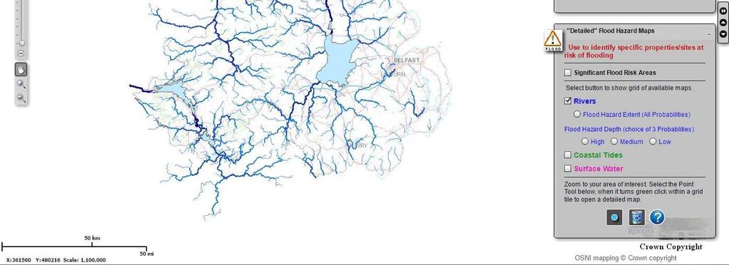
6 Settlements & Rivers Northern Ireland - Overview
7 Northern Ireland - Overview Settlements & Rivers Flooded Properties (since 2007)
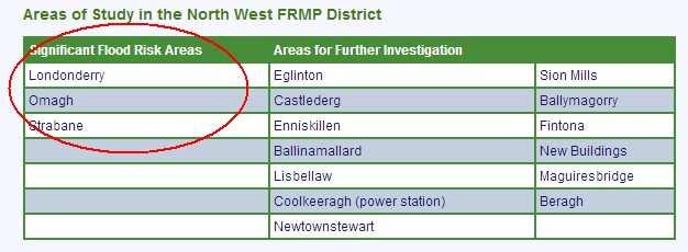
8 Northern Ireland - Overview Settlements & Rivers Significant Flood Risk Areas & Areas for Further Study


9 Derry City & Strabane Settlements & Rivers Significant Flood Risk Areas & Areas for Further Study Settlement SFRA or AFS Londonderry Strabane Ballymagorry Coolkeeragh Power Station Eglington New Buildings Newtonstewart Sion Mills SFRA SFRA AFS AFS AFS AFS AFS AFS


10 Derry City & Strabane Settlements & Rivers Significant Flood Risk Areas & Areas for Further Study Settlement SFRA or AFS Londonderry Strabane Ballymagorry Coolkeeragh Power Station Eglington New Buildings Newtonstewart Sion Mills SFRA SFRA AFS AFS AFS AFS AFS AFS
11 Detailed Maps - Flood Hazard What the Directive requires... See following slides for examples of Flood Hazard...


12 Flood Hazard Flood Extent for 3 scenarios

13 Flood Hazard Medium Probability, Depth, Level, Velocity
14 Detailed Maps - Flood Risk - What the Directive Requires... See handouts for example of Flood Risk...

15 Flood Risk High Probability, Damages, Inhabitants Affected, etc

16 Flood Risk Medium Probability, Damages, Inhabitants Affected, etc
17 Flood Risk Low Probability, Damages, Inhabitants Affected, etc
18 Flood Hazard pdf Maps NI v [Derry City & Strabane] Flood Source Fluvial Surface Water Tidal Ref Description Plot Size / Scale FH1 FH2 FH3 FH4 SH1 SH2 SH3 SH4 TH1 TH2 TH3 TH4 Flood Extent, 3 probabilities Flood Depth, Q10 Flood Depth, Q100 Flood Depth, Q1000 Flood Extent, 3 probabilities Flood Depth, 30 year rainfall Flood Depth, 200 year rainfall Flood Depth, 1000 year rainfall Flood Extent, 3 probabilities Flood Depth, 10 year tidal Flood Depth, 200 year tidal Flood Depth, 1000 year tidal NI Total Council Total A3, 1:5000 2, (12%) A3, 1:10,000 2, (8%) A3, 1:10, (31%) Flood Risk maps have been produced for Fluvial & Tidal only - A3,1:20,000
19 Agenda 1) Floods Directive Flood Hazard & Flood Risk Maps 2) Access to Flood Mapping Information 3) Further Work 4) Questions

20 Public Access Flood Maps NI

21 Rivers Agency and LPS partnership for licensing Flood Mapping products. The Flood Mapping products are now included in NIMA, which means they are available NIMA customers or those working on behalf of NIMA customers (this includes all Northern Ireland Civil Service Departments, Agencies, Non Departmental Public Bodies and Councils).
 Licensed Flood Mapping services available now via Flood Maps (NI)")
22 Government access to Flood Mapping Data Flood Mapping has been provided to Planning NI; and has now been included on the Planning Portal. Flood Mapping has been provided to Spatial NI; in the future the detail flood mapping will be readily available to Planning staff in the Councils, for use within their desktop GIS systems (e.g. in developing Area Development Plans) Licensed Flood Mapping services available now via Flood Maps (NI)
23 Agenda 1) Floods Directive Flood Hazard & Flood Risk Maps 2) Access to Flood Mapping Information 3) Further Work 4) Questions
24 Flood Animations Outputs from the Flood Models may also be used to create animations of flood events Can be useful for understanding flooding mechanisms, and an aid in developing emergency plans. Animations are on FloodRiskManagementNI Vimeo website


25 Reservoir Flood Mapping Detailed Reservoir Flood Maps are being produced for approx 130 reservoirs. Models & Maps are to a similar specification to those produced in England & Wales Planning considerations fall under PPS15 (FLD5)
26 Flood Re UK Scheme to provide Affordable Flood Insurance Flood Re replaces the Statement of Principles Objective is to ensure domestic properties in UK at highest risk of flooding can receive affordable cover for the flood element of their household property insurance Applies to domestic properties only; commercial properties excluded New housing development should be located to avoid flood risk, therefore properties built after 1 st Jan 09 will be excluded. Secondary Legislation (Scheme Regulations), was laid before UK parliament April 15. For more information: DEFRA Water Bill: Pt4 Flood Insurance ABI Flood Re Explained
27 Questions? Malcolm Calvert (Principal Engineer, Mapping & Modelling Unit) Sean O Neill (Regional Engineer - Western) Rivers Agency, Mapping & Modelling Unit, Hydebank, 4 Hospital Road, Ballydolloghan, Belfast, BT8 8JP malcolm.calvert@dardni.gov.uk Website:
28 Other Resources Item Watercourse Designations Link Annual Maintenance Programme Draft Flood Risk Management Plans (Consultation) PPS15 (Revised) onsultation-on-draft-flood-risk-managementplans.htm ning_statements/pps15revised-2.htm
29 The 3 Ps Flood Risk Management - The 3 Ps Prevention Protection Preparedness
30 The 3 Ps Prevention Prevent future development that may be at risk of flooding or that may increase the risk of flooding elsewhere. May also include the relocation of specific high risk receptors Measure Type Land use planning policies to prevent the location of additional receptors in flood prone areas. Remove receptor from floodplain or to a location with a reduced flood hazard (i.e. depth, velocity, return period) Measures Consider revision of Planning Policy Statement 15 Planning and Flood Risk to maximise compliance with Floods Directive. For example, address risk from additional sources such as surface water, reservoir impoundment failure and review climate change epoch. Consider government policy on managed realignment/ property relocation.


31 The 3 Ps Prevention. PPS 15 - Planning and Flood Risk Prevention The primary means of avoiding and reducing flood risk to and from new development Build Here Not Here
32 Protection The 3 Ps Taking measures (both structural and non-structural) to reduce the likelihood of floods and/or their impact of floods in a specific location. Measure Type Hard Engineering Soft Engineering Natural Flood Management Building Flood Resistance Key/Critical Infrastructure Flood Resistance * (following FRA by owner/operator). Flood Defences (walls/embankments) Culverts/channels Diversionary channels Upstream Flood Storage Areas Channel Re-sectioning and/or Realignment Restore drained bogs Restore/Create wetland habitats Plant native forests in upland areas Install water-tight flood shields Install anti-backflow valves on sewer outlets Community Flood Warden Scheme Flood proofing grant scheme for homeowners Local permanent or demountable defence systems Measures Demountable barriers Off-line storage SUDs (new-build & retrofit) Managing exceedance flows within urban landscape Risk focused channel maintenance Removal of existing rural flood banks Plant wet woodland within floodplain Blocking of forest drains Restore natural river channels Raise ground floor level above flood level Impermeable external walls Develop Building Regulations/Guidance
33 Preparedness Raising awareness of flood risk and planning for emergency response and recovery. The 3 Ps Measure Type Measures Raise Awareness Assess/Map/Inform/Advise Local Flood Forums Emergency Response Flood forecasting Flood warning Multi- Agency Emergency Response Plans Local Community Flood Plans Controlled Reservoir Flood Plans Feedback mechanisms for lessons learnt Building/Asset Flood Resilience Resistant construction materials Moveable appliances Flood proofing grant scheme for homeowners Raise services above flood level. Develop Building Regulations/Guidance Key/Critical Infrastructure Resilience** (Following Flood Risk Assessment by owner/operator). Review and agree standards for resilience of Critical Infrastructure Business Continuity Plans Networking of services to minimise interruptions to delivery. Ensure availability of generators to buffer affects of power outage to critical asset. Robust provisions for procurement of external resources for incident management. Flood Insurance Government/ABI cooperation to maximise accessibility to flood insurance.
Joint Lincolnshire Flood Risk and Drainage Management Strategy: Draft v.6.0:consultation Draft, : Annexes A-F
 Lincolnshire Flood Risk and Drainage Management Partnership Framework Lincolnshire Joint Flood Risk and Drainage Management Strategy Draft v.6.0 Consultation Draft 23 rd May 2012 Annexes A-F Joint Lincolnshire
Development and Flood Risk - the Environment Agency s approach to PPS25. scrutinised before planning decisions are made
 Development and Flood Risk - the Environment Agency s approach to PPS25 Steve Cook Flood Risk Policy Advisor Stephen.cook@environment-agency.gov.uk Our role in PPS25 h Providing advice and information
Assessing future flood risk across the UK
 Climate Change Risk Assessment: 2017 Assessing future flood risk across the UK (England, Wales, Scotland and Northern Ireland) Presentation to the FoRUM Workshop Paul Sayers and Matt Horritt 17 March 2015
Planning and Flood Risk
 Planning and Flood Risk Patricia Calleary BE MEngSc MSc CEng MIEI After the Beast from the East Patricia Calleary Flood Risk and Planning Flooding in Ireland» Floods are a natural and inevitable part of
Background to the PFRA European Overview - UC9810.5b
 Background to the PFRA European Overview - UC9810.5b The individual Member State Reports reflect the situation as reported by the Member States to the European Commission in 2012 The situation in the MSs
FLOODING INFORMATION SHEET YOUR QUESTIONS ANSWERED
 The information in this document has been written in partnership by the Association of British Insurers and the Environment Agency 1. Flood risk and insurance Q1. How can I find out the flood risk affecting
STRATEGIC FLOOD RISK ASSESSMENT
 STRATEGIC FLOOD RISK ASSESSMENT FOR PROPOSED VARIATION NO. 1 (CORE STRATEGY) TO THE LONGFORD TOWN DEVELOPMENT PLAN 2009-2015 for: Longford Local Authorities Great Water Street, Longford, Co. Longford by:
PROPERTY CODES COMPLIANCE BOARD COMPLIANCE NOTES CN02I: REGULATED FLOOD SEARCHES
 PROPERTY CODES COMPLIANCE BOARD COMPLIANCE NOTES CN02I: REGULATED FLOOD SEARCHES The Code s requirements 1. The 7 principles of the Search Code apply to regulated flood searches just as they apply to regulated
Mapping flood risk its role in improving flood resilience in England
 Mapping flood risk its role in improving flood resilience in England Catherine Wright Director of Digital and Skills Flood and Coastal Risk Management Environment Agency 6 October 2017 The Environment
Engineers Ireland Annual Conference
 Engineers Ireland Annual Conference MANAGING FLOOD RISK AND BUILDING SUSTAINABLE COMMUNITIES Mark Adamson Office of Public Works 15 th May, 2015 FLOOD RISK IN IRELAND RECENT FLOODS November 2009: >1,600
Solway Local Plan District 1 Flood risk management in Scotland 1.1 What is a Flood Risk Management Strategy? Flood Risk Management Strategies have bee
 Flood Risk Management Strategy Solway Local Plan District Section 1: Flood Risk Management in Scotland 1.1 What is a Flood Risk Management Strategy?... 1 1.2 How to read this Strategy... 1 1.3 Managing
FOR TO THE GAELTACHT LOCAL AREA PLAN MARCH 2013
 APPENDIX II TO THE SEA ENVIRONMENTAL REPORT STAGE 2 STRATEGIC FLOOD RISK ASSESSMENT FOR PROPOSED AMENDMENT TO THE GAELTACHT LOCAL AREA PLAN 2008-2014 for: Galway County Council County Buildings Prospect
The Planning System and Flood Risk Management Guidelines for Planning Authorities
 Technical Appendices November 2009 Contents PAGE A. Identification and Assessment of Flood Risk 1 B. Addressing Flood Risk Management in Design of Development 35 A Appendix A: Identification and Assessment
Flood Risk Management Planning in Scotland: Arrangements for February 2012
 Flood Risk Management Planning in Scotland: Arrangements for 2012 2016 February 2012 Flood Risk Management (Scotland) Act 2009 1 Contents Forewords 1. Introduction to this document... 5 2. Sustainable
Flood Risk Management in Ireland. The National CFRAM Programme & overview of the Capital Works Programme. Click to add text
 Flood Risk Management in Ireland The National CFRAM Programme & overview of the Capital Works Programme Click to add text Dr. John Martin Office of Public Works Engineers Ireland's Local Government Seminar
Guildford Borough Level 1 Strategic Flood Risk Assessment Summary Report. January 2016
 Guildford Borough Level 1 Strategic Flood Risk Assessment Summary Report January 2016 What is this document? This document provides a summary of Guildford Borough Strategic Flood Risk Assessment (SFRA,
2018 PREPARING FOR A CHANGING CLIMATE AND MANAGING THE RISING FLOOD RISK
 Ireland Water 2018 PREPARING FOR A CHANGING CLIMATE AND MANAGING THE RISING FLOOD RISK Mark Adamson Office of Public Works 25 th April, 2018 FLOOD RISK IN IRELAND NATIONAL RISK ASSESSMENT, OEP 2012 & 2017
THE EU FLOODS DIRECTIVE:
 Sixth Bulgarian Austrian Seminar THE EU FLOODS DIRECTIVE: EUROPEAN PRACTICE AND RESEARCH IN FLOOD RISK MANAGEMENT Mark Adamson Co-Chair, Working Group F Office of Public Works, IE 7 th November, 2013 PRESENTATION
Consider the risks to your own business as well as to your operations
 Hayley Bowman Flood and Coastal Risk Management Mapping, Modelling and Data 07919 544 551 Hayley.bowman@environment-agency.gov.uk DataInfo@environment-agency.gov.uk EA covers England only. Wales covered
Canada s exposure to flood risk. Who is affected, where are they located, and what is at stake
 Canada s exposure to flood risk Who is affected, where are they located, and what is at stake Why a flood model for Canada? Catastrophic losses Insurance industry Federal government Average industry CAT
Shropshire Local Flood Risk Management Strategy. Summary for Consultation. July 2014
 Shropshire Local Flood Risk Management Strategy Summary for Consultation July 2014 SHROPSHIRE LOCAL FLOOD RISK MANAGEMENT STRATEGY 1 Introduction This Strategy is about managing flooding in Shropshire.
Working with natural processes to help manage flood risk natural flood management Dr. Heather Forbes. Scottish Environment Protection Agency
 Working with natural processes to help manage flood risk natural flood management Dr. Heather Forbes Senior Policy Officer Programme Scottish Environment Protection Agency Scotland s flood risk 56% 21%
Comhairle Baile Cheanntair~ Nás na Ríogh
 Comhairle Baile Cheanntair~ Nás na Ríogh DRAFT STRATEGIC FLOOD RISK ASSESSMENT NAAS TOWN DEVELOPMENT PLAN 2011 ~ 2017 Kildare County Council Water Services Department Aras Chill Dara Devoy Park Naas County
Lowestoft Flood Risk Management Project
 Volume 1, Issue 1 Winter 2017 Lowestoft Flood Risk Management Project I N S I D E T H I S I S S U E : Welcome 1 Background to the project 2 What are we considering 2 and how has the project progressed?
Good Practice Guide. GPG 101 Document Owner: Steve Cook. Page 1 of 7.
 Good Practice Guide Producing flood risk hydraulic models and flood consequence assessments for development planning purposes Date Published: September 2015 GPG 101 Document Owner: Steve Cook Page 1 of
Flood Risk Management Strategy. Shetland
 Flood Risk Management Strategy Shetland Publication date: 14 December 2015 Terms and conditions Ownership: All intellectual property rights for Flood Risk Management Strategies are owned by SEPA or its
FLOOD RISK MANAGEMENT IN IRELAND
 National Flood Management Conference 2018 FLOOD RISK MANAGEMENT IN IRELAND Mark Adamson Office of Public Works 15 th March, 2018 FLOOD RISK IN IRELAND NATIONAL RISK ASSESSMENT, OEP 2012 Flooding: Joint
ABI RESPONSE TO PITT INTERIM REPORT: OVERVIEW
 ABI RESPONSE TO PITT INTERIM REPORT: OVERVIEW The ABI broadly supports the recommendations and interim conclusions contained in the Pitt interim report on flood policy issues, although we believe that
LINCOLNSHIRE COUNTY COUNCIL A DRAINAGE AUTHORITY and what it will mean for Lincolnshire MARK WELSH & DAVID HICKMAN THE LEGISLATION:
 LINCOLNSHIRE COUNTY COUNCIL A DRAINAGE AUTHORITY and what it will mean for MARK WELSH & DAVID HICKMAN ADA Local Authority Seminar Thursday 17 March 2010 Great Northern Hotel, Peterborough THE LEGISLATION:
LOW. Overall Flood risk. Flood considerations. Specimen Address, Specimen Town. Rivers and the Sea Low page 4. Historic Flood.
 Specimen Address, Specimen Town Overall Flood risk LOW Crown copyright and database rights 2018. Ordnance Survey licence 100035207 Groundsure Floodview complies with relevant Law Society practice notes
CHAPTER 10 FLOOD RISK
 CHAPTER 10 FLOOD RISK 10.1 Introduction and Key Issues 10.1.1 This chapter describes the likely effects that the construction and operation of the Upgrade will have on flood risk. The potential effects
Local Government Group. Preliminary Framework to assist the development of the Local Strategy for Flood Risk Management.
 Preliminary Framework to assist the development of the Local Strategy for Flood Risk Management A Living Document February 2011 Preliminary Framework for Local Flood Risk Management Strategy Page 1 Table
Strategic Flood Risk Assessment
 Strategic Flood Risk Assessment Draft Claremorris Local Area Plan 2012 2018 Prepared by Forward Planning Section Mayo County Council 1 Table of Contents Section 1: Overview of the Guidelines... 4 1.1 Introduction...
STATUTORY INSTRUMENTS. S.I. No. 122 of EUROPEAN COMMUNITIES (ASSESSMENT AND MANAGEMENT OF FLOOD RISKS) REGULATIONS 2010.
 REGULATIONS 2010.") STATUTORY INSTRUMENTS. S.I. No. 122 of 2010. EUROPEAN COMMUNITIES (ASSESSMENT AND MANAGEMENT OF FLOOD RISKS) REGULATIONS 2010. (Prn. A10/0432) 2 [122] S.I. No. 122 of 2010. EUROPEAN COMMUNITIES (ASSESSMENT
STATUTORY INSTRUMENTS. S.I. No. 122 of 2010. EUROPEAN COMMUNITIES (ASSESSMENT AND MANAGEMENT OF FLOOD RISKS) REGULATIONS 2010. (Prn. A10/0432) 2 [122] S.I. No. 122 of 2010. EUROPEAN COMMUNITIES (ASSESSMENT
Understanding the risks, empowering communities, building resilience: the national flood and coastal erosion risk management strategy for England
 14669 NFS Cor Slip / Sig: 1 / Plate A Understanding the risks, empowering communities, building resilience: the national flood and coastal erosion risk management strategy for England Session: 2010-2012
FREQUENTLY ASKED QUESTION ABOUT FLOODPLAINS Michigan Department of Environmental Quality
 FREQUENTLY ASKED QUESTION ABOUT FLOODPLAINS Michigan Department of Environmental Quality WHAT IS A FLOOD? The National Flood Insurance Program defines a flood as a general and temporary condition of partial
Local Flood Risk Management Strategy
 of London Local Flood Risk Management Strategy 2014-2020 September 2014 of London Local Flood Risk Management Strategy 2014-2020 Sept 2014 1 Contents 1 Introduction... 4 2 Flood Risk Management Strategy
Creetown (Potentially Vulnerable Area 14/17) Local Plan District Local authority Main catchment Dumfries and Galloway Solway Moneypool Burn Council Ba
 Local Plan District Local authority Main catchment Dumfries and Galloway Solway Moneypool Burn Council Ba") Creetown (Potentially Vulnerable Area 14/17) Local Plan District Solway Local authority Dumfries and Galloway Council Main catchment Moneypool Burn Summary of flooding impacts 90 residential properties
Creetown (Potentially Vulnerable Area 14/17) Local Plan District Solway Local authority Dumfries and Galloway Council Main catchment Moneypool Burn Summary of flooding impacts 90 residential properties
RIVER LUGG INTERNAL DRAINAGE BOARD. Statement on Water Level and Flood Risk Management
 RIVER LUGG INTERNAL DRAINAGE BOARD Statement on Water Level and Flood Risk Management 1. Introduction Purpose 1.1. This policy statement has been prepared by the River Lugg Internal Drainage Board (the
Chelmsford City Council. Level 1 and Level 2 Strategic Flood Risk Assessment. Final Report
 Chelmsford City Council Level 1 and Level 2 Strategic Flood Risk Assessment Final Report October 2017 This page has been left intentionally blank 2015s3715 Chelmsford SFRA L1 and L2 Final Report v1.0.docx
Chapter Flood Consequences
 Chapter 2.16. Flood Consequences 438 16. Flood Consequences 16.1. Introduction and Scope of Topic 16.1.1. This chapter identifies and describes the existing flood risk features along the route of the Scheme
Flood Risk Management New legislation New Duties!
 Flood Risk Management New legislation New Duties! Andy Cameron Lancashire County Council Senior Engineer Strategic Flood Risk Iwan Lawton Environment Agency Technical Specialist Development & Flood Risk
Objectives of this Briefing
 Eastern CFRAM Study (Catchment Flood Risk Assessment & Management) Stakeholders Briefing Poddle & Camac Watercourses Overview Grace Glasgow July 2013 Burns Beach near Brighton, Western Australia RPS has
Unique ID: (from PFRA database) Location: Bridgetown, Co. Clare. Stage 1: Desktop Review
 Location: Bridgetown, Co. Clare. Stage 1: Desktop Review") Location:, Co. Clare Unique ID: 250412 (from PFRA database) Initial OPW Designation APSR AFRR IRR Co-ordinates Easting: 164500 Northing: 168500 River / Catchment / Sub-catchment Black River / Shannon Type
Location:, Co. Clare Unique ID: 250412 (from PFRA database) Initial OPW Designation APSR AFRR IRR Co-ordinates Easting: 164500 Northing: 168500 River / Catchment / Sub-catchment Black River / Shannon Type
Regulations Regarding Preliminary Flood Risk Assessment, Flood Maps and Flood Risk Management Plan
 Text consolidated by Valsts valodas centrs (State Language Centre) with amending regulations of: 20 March 2012 [shall come into force from 23 March 2012]. If a whole or part of a paragraph has been amended,
Strategic Flood Risk Assessment for SDCC Development Plan
 Strategic Flood Risk Assessment for SDCC Development Plan Detailed Report on Flood Risk in the Baldonnell Area 8 th May 2015 rpsgroup.com/ireland Strategic Flood Risk Assessment for SDCC Development Plan
Document Control Sheet
 Strategic Flood Risk Assessment of the Maynooth Local Area Plan 2013-2019 Proposed Amendment No. 1 Document Control Sheet Client: Project Title: Document Title: Document No: Kildare County Council Strategic
Role of the Flood & Water Management Committee & LCC as Lead Local Flood Authority
 Role of the Flood & Water Management Committee & LCC as Lead Local Flood Authority Page 1 Agenda Item 5 Page 2 21F of Local Government Act 2000 - Overview and scrutiny committees: flood risk management
Glossary. Annual Average Damages (AAD) Benefit cost ratio (BCR)
 Benefit cost ratio (BCR)") Glossary Term Accretion Actions Annual Average Damages (AAD) Appraisal Appraisal baseline Awareness raising Bathing waters Benefit cost ratio (BCR) Blue infrastructure Accumulation of sediment. Activities
Glossary Term Accretion Actions Annual Average Damages (AAD) Appraisal Appraisal baseline Awareness raising Bathing waters Benefit cost ratio (BCR) Blue infrastructure Accumulation of sediment. Activities
Flood Risk Assessment Appendix 1 to Strategic Environmental Assessment Screening of Amendment No. 1 to Ferrybank/Belview Local Area Plan
 Flood Risk Assessment Appendix 1 to Strategic Environmental Assessment Screening of Amendment No. 1 to Ferrybank/Belview Local Area Plan Forward Planning Kilkenny County Council 18/8/2011 1 Introduction
A GUIDE TO BEST PRACTICE IN FLOOD RISK MANAGEMENT IN AUSTRALIA
 A GUIDE TO BEST PRACTICE IN FLOOD RISK MANAGEMENT IN AUSTRALIA McLuckie D. For the National Flood Risk Advisory Group duncan.mcluckie@environment.nsw.gov.au Introduction Flooding is a natural phenomenon
Kirkwall (Potentially Vulnerable Area 03/05) Local Plan District Local authority Main catchment Orkney Orkney Islands Council Orkney coastal Backgroun
 Local Plan District Local authority Main catchment Orkney Orkney Islands Council Orkney coastal Backgroun") Kirkwall (Potentially Vulnerable Area 03/05) Local Plan District Orkney Local authority Orkney Islands Council Main catchment Orkney coastal Summary of flooding impacts 490 residential properties 460 non-residential
Kirkwall (Potentially Vulnerable Area 03/05) Local Plan District Orkney Local authority Orkney Islands Council Main catchment Orkney coastal Summary of flooding impacts 490 residential properties 460 non-residential
Environment Agency pre-application advice incorporating Local Flood Risk Standing Advice from East Lindsey District Council
 Environment Agency pre-application advice incorporating Local Flood Risk Standing Advice from East Lindsey District Council Version 1 UNCLASSIFIED We are the Environment Agency. We protect and improve
HRPP 358. Adapting flood risk management for an uncertain future: Flood management planning on the thames estuary. D. Ramsbottom & T.
 HRPP 358 Adapting flood risk management for an uncertain future: Flood management planning on the thames estuary D. Ramsbottom & T. Reeder Reproduced from a paper presented at: The 43rd Defra Flood and
Strategic Flood Risk Assessment
 Strategic Flood Risk Assessment Ireland West Airport Knock Local Area Plan 2012 2018 Prepared by Forward Planning Section Mayo County Council 0 1 Table of Contents Section 1: Overview of the Guidelines...
Nairn Central (Potentially Vulnerable Area 01/18) Local authority Main catchment The Highland Council Moray coastal Background This Potentially Vulner
 Local authority Main catchment The Highland Council Moray coastal Background This Potentially Vulner") Nairn Central (Potentially Vulnerable Area 01/18) Local authority The Highland Council Main catchment Moray coastal Summary of flooding impacts At risk of flooding 350 residential 30 non-residential 340,000
Nairn Central (Potentially Vulnerable Area 01/18) Local authority The Highland Council Main catchment Moray coastal Summary of flooding impacts At risk of flooding 350 residential 30 non-residential 340,000
CYNGOR SIR POWYS COUNTY COUNCIL. CABINET EXECUTIVE 18 th September Flood Risk Management Plan (FRMP)
") CYNGOR SIR POWYS COUNTY COUNCIL. CABINET EXECUTIVE 18 th September 2018 REPORT AUTHOR: SUBJECT: County Councillor Phyl Davies Portfolio Holder for Highways, Recycling and Assets Flood Risk Management Plan
CYNGOR SIR POWYS COUNTY COUNCIL. CABINET EXECUTIVE 18 th September 2018 REPORT AUTHOR: SUBJECT: County Councillor Phyl Davies Portfolio Holder for Highways, Recycling and Assets Flood Risk Management Plan
A brief introduction to the Flood (Risk) Directive. Jan Verkade, M.A. Delft Hydraulics
 Directive. Jan Verkade, M.A. Delft Hydraulics") A brief introduction to the Flood (Risk) Directive Jan Verkade, M.A. Delft Hydraulics Flood Risk Directive s full name: Directive 2007/60/EC of the European Parliament and of the Council on the assessment
A brief introduction to the Flood (Risk) Directive Jan Verkade, M.A. Delft Hydraulics Flood Risk Directive s full name: Directive 2007/60/EC of the European Parliament and of the Council on the assessment
STAGE 2 STRATEGIC FLOOD RISK ASSESSMENT (AS AMENDED)
") STAGE 2 STRATEGIC FLOOD RISK ASSESSMENT (AS AMENDED) FOR PROPOSED AMENDMENTS TO THE CLIFDEN LOCAL AREA PLAN 2009-2015 for: Galway County Council County Buildings Prospect Hill Galway by: CAAS Ltd. 2 nd
STAGE 2 STRATEGIC FLOOD RISK ASSESSMENT (AS AMENDED) FOR PROPOSED AMENDMENTS TO THE CLIFDEN LOCAL AREA PLAN 2009-2015 for: Galway County Council County Buildings Prospect Hill Galway by: CAAS Ltd. 2 nd
Strategic Flood Risk Assessment: A Local Authority Perspective. Karyn Punchard, Weymouth & Portland Borough Council
 Strategic Flood Risk Assessment: A Local Authority Perspective Karyn Punchard, Weymouth & Portland Borough Council Workshop Flooding issues in Weymouth & Portland SFRA Level 1 2005/6 SFRA Level 2 2008/9
Review of preliminary flood risk assessments (Flood Risk Regulations 2009): guidance for lead local flood authorities in England
: guidance for lead local flood authorities in England") Review of preliminary flood risk assessments (Flood Risk Regulations 2009): guidance for lead local flood authorities in England 25 January 2017 We are the Environment Agency. We protect and improve the
Review of preliminary flood risk assessments (Flood Risk Regulations 2009): guidance for lead local flood authorities in England 25 January 2017 We are the Environment Agency. We protect and improve the
MONAGHAN COUNTY COUNCIL. Strategic Flood Risk Assessment for County Monaghan
 MONAGHAN COUNTY COUNCIL Strategic Flood Risk Assessment for County Monaghan November2017 Table of Contents 1.0: Introduction Page: 5 1.1: Objectives Page: 5 1.2: Study Area Page: 5 1.3: EU Floods Directive
FLOOD SOLUTIONS Residence
 FLOOD SOLUTIONS Residence Report prepared on 22 Knighton Road, Liverpool, L4 9RD Report reference AEL028FLR022381 National grid reference 337815, 394462 Report prepared for Specimen Client Client reference
Evidence for Environmental Audit Committee Enquiry on Sustainable Housing Submission by Association of British Insurers, May 2004
 Evidence for Environmental Audit Committee Enquiry on Sustainable Housing Submission by Association of British Insurers, May 2004 The Government s plans to tackle the country s profound housing shortage
Resilience to Flooding of Grid and Primary Substations
 PRODUCED BY THE OPERATIONS DIRECTORATE OF ENERGY NETWORKS ASSOCIATION Engineering Technical Report 138 Resilience to Flooding of Grid and Primary Substations www.energynetworks.org PUBLISHING AND COPYRIGHT
Strategic flood risk management
 Report by the Comptroller and Auditor General Department for Environment, Food & Rural Affairs and Environment Agency Strategic flood risk management HC 780 SESSION 2014-15 5 NOVEMBER 2014 4 Key facts
Unique ID: (from PFRA database) Location: Nenagh, Co. Tipperary. Stage 1: Desktop Review
 Location: Nenagh, Co. Tipperary. Stage 1: Desktop Review") Location: Nenagh, Co. Tipperary Unique ID: 250432 (from PFRA database) Initial OPW Designation APSR AFRR IRR Co-ordinates Easting: 186604 Northing: 178781 River / Catchment / Sub-catchment Nenagh River
Location: Nenagh, Co. Tipperary Unique ID: 250432 (from PFRA database) Initial OPW Designation APSR AFRR IRR Co-ordinates Easting: 186604 Northing: 178781 River / Catchment / Sub-catchment Nenagh River
FURTHER ACTION CLICK TO VIEW ONLINE VIEWER. Individual Flood Risks
 Homecheck Flood FURTHER ACTION Overall Flood Risk CLICK TO VIEW ONLINE VIEWER The property is at a significant risk of River, Surface Water and Other flooding. Further assessment is recommended to understand
Flood Report Flood Risk Assessment
 Flood Report Flood Risk Assessment This report is issued for the property described as: PASSED Professional Opinion The Strand, Saundersfoot The overall flood risk rating for the property has been assessed
Celbridge. Local Area Plan STRATEGIC FLOOD RISK ASSESSMENT
 Celbridge Local Area Plan 2017-2023 Dréachtphlean Ceantair Áitiúil Cill Droichid STRATEGIC FLOOD RISK ASSESSMENT Planning Department Kildare County Council September 2017 Strategic Flood Risk Assessment
Clyde south - Port Glasgow to Inchinnan (Potentially Vulnerable Area 11/09) Local Plan District Clyde and Loch Lomond Local authority Inverclyde Counc
 Local Plan District Clyde and Loch Lomond Local authority Inverclyde Counc") Clyde south - Port Glasgow to Inchinnan (Potentially Vulnerable Area 11/09) Local Plan District Clyde and Loch Lomond Local authority Inverclyde Council, Renfrewshire Council Main catchment Firth of Clyde
Clyde south - Port Glasgow to Inchinnan (Potentially Vulnerable Area 11/09) Local Plan District Clyde and Loch Lomond Local authority Inverclyde Council, Renfrewshire Council Main catchment Firth of Clyde
Newton Stewart (Potentially Vulnerable Area 14/12) Local Plan District Local authority Main catchment Dumfries and Galloway Solway River Cree Council
 Local Plan District Local authority Main catchment Dumfries and Galloway Solway River Cree Council") Newton Stewart (Potentially Vulnerable Area 14/12) Local Plan District Solway Local authority Dumfries and Galloway Council Main catchment River Cree Summary of flooding impacts 210 residential properties
Newton Stewart (Potentially Vulnerable Area 14/12) Local Plan District Solway Local authority Dumfries and Galloway Council Main catchment River Cree Summary of flooding impacts 210 residential properties
Preliminary Flood Risk Assessment (PFRA) Final guidance
 Final guidance") 07/12/2010 Preliminary Flood Risk Assessment (PFRA) Final guidance Report GEHO1210BTGH-E-E i 07/12/2010 We are The Environment Agency. It's our job to look after your environment and make it a better place
07/12/2010 Preliminary Flood Risk Assessment (PFRA) Final guidance Report GEHO1210BTGH-E-E i 07/12/2010 We are The Environment Agency. It's our job to look after your environment and make it a better place
Oban (Potentially Vulnerable Area 01/31) Local authority Main catchment Argyll and Bute Council Knapdale coastal Background This Potentially Vulnerabl
 Local authority Main catchment Argyll and Bute Council Knapdale coastal Background This Potentially Vulnerabl") Oban (Potentially Vulnerable Area 01/31) Local authority Argyll and Bute Council Main catchment Knapdale coastal Summary of flooding impacts 320 residential properties 310 non-residential properties 1.8
Oban (Potentially Vulnerable Area 01/31) Local authority Argyll and Bute Council Main catchment Knapdale coastal Summary of flooding impacts 320 residential properties 310 non-residential properties 1.8
Annex 1: Glossary. Annual Average Damages (AAD) Benefit cost ratio (BCR) Candidate Potentially Vulnerable Area (PVAc)
 Benefit cost ratio (BCR) Candidate Potentially Vulnerable Area (PVAc)") Annex 1: Glossary Term Accretion Actions Annual Average Damages (AAD) Appraisal Appraisal baseline Awareness raising Bathing waters Benefit cost ratio (BCR) Blue infrastructure Candidate Potentially Vulnerable
Annex 1: Glossary Term Accretion Actions Annual Average Damages (AAD) Appraisal Appraisal baseline Awareness raising Bathing waters Benefit cost ratio (BCR) Blue infrastructure Candidate Potentially Vulnerable
Volume. 10c. Clare County Development Plan Strategic Flood Risk Assessment
 Volume 10c Clare County Development Plan 2017 2023 Strategic Flood Risk Assessment Elizabeth Russell 24 Grove Island Corbally Limerick Ireland This report describes work commissioned by Brian McCarthy,
A Flood Mitigation Plan for the Non-Tidal N.J. Section of the Delaware River Basin. Warren County Planning Workshop (2 nd Meeting) March 7, 2007
 March 7, 2007") A Flood Mitigation Plan for the Non-Tidal N.J. Section of the Delaware River Basin Warren County Planning Workshop (2 nd Meeting) March 7, 2007 Study Area Participation: Hunterdon: 16 Eligible Municipalities
A Flood Mitigation Plan for the Non-Tidal N.J. Section of the Delaware River Basin Warren County Planning Workshop (2 nd Meeting) March 7, 2007 Study Area Participation: Hunterdon: 16 Eligible Municipalities
STRATEGIC FLOOD RISK ASSESSMENT
 STRATEGIC FLOOD RISK ASSESSMENT UNDERTAKEN AS PART OF THE PREPARATION OF PROPOSED VARIATION NO. 2 (A) TO THE GALWAY COUNTY DEVELOPMENT PLAN 2015-2021 BEARNA PLAN for: Galway County Council Áras an Chontae
Skardu, Pakistan. Local progress report on the implementation of the 10 Essentials for Making Cities Resilient (First Cycle)
") Skardu, Pakistan Local progress report on the implementation of the 10 Essentials for Making Cities Resilient (First Cycle) Name of focal point: Habib Mughal Organization: UN-HABITAT - Pakistan Title/Position:
Skardu, Pakistan Local progress report on the implementation of the 10 Essentials for Making Cities Resilient (First Cycle) Name of focal point: Habib Mughal Organization: UN-HABITAT - Pakistan Title/Position:
Homecheck Professional. Flood Risk Assessment. Overall Flood Risk at the Site: Insurability: PASSED LOW RISK IDENTIFIED YES.
 Homecheck Professional Flood Report Flood Risk Assessment This report is issued for the property described as: PASSED Sample site Professional Opinion The overall flood risk rating for the property is
Government Decree on Flood Risk Management 659/2010
 Ministry of Agriculture and Forestry, Finland NB: Unofficial translation; legally binding texts are those in Finnish and Swedish. Government Decree on Flood Risk Management 659/2010 Section 1 Preliminary
CLARBOROUGH AND WELHAM PARISH COUNCIL A FLOOD PREVENTION AND FLOOD MANAGEMENT STRATEGY. FLOOD PREVENTION STRATEGY DRAFT2 5 Sep 2017.
 CLARBOROUGH AND WELHAM PARISH COUNCIL A FLOOD PREVENTION AND FLOOD MANAGEMENT STRATEGY FLOOD PREVENTION STRATEGY DRAFT2 5 Sep 2017.docx 1 BACKGROUND Houses, businesses and land within the Parish of Clarborough
Flood Risk Assessment. Approved by RECOMMENDATIONS. Professional Opinion
 Flood Report Flood Risk Assessment Professional Opinion RECOMMENDATIONS 1. A prudent purchaser may wish to consider further assessment of the property to identify appropriate flood protection measures.
Flood Risk Management in the EU and the Floods Directive's 1 st Cycle of Implementation ( )
") COMMON IMPLEMENTATION STRATEGY FOR THE WATER FRAMEWORK DIRECTIVE AND THE FLOODS DIRECTIVE Flood Risk Management in the EU and the Floods Directive's 1 st Cycle of Implementation (2009-15) A questionnaire
COMMON IMPLEMENTATION STRATEGY FOR THE WATER FRAMEWORK DIRECTIVE AND THE FLOODS DIRECTIVE Flood Risk Management in the EU and the Floods Directive's 1 st Cycle of Implementation (2009-15) A questionnaire
Future proofing New and Existing Buildings Flood Resilient Design and Construction Techniques
 Future proofing New and Existing Buildings Flood Resilient Design and Construction Techniques Katy Hunter BRE Scotland 28 th April 2015 Part of the BRE Trust Introduction Who are BRE Flood Risk in the
River Lugg Internal Drainage Board. Policy Statement on Flood Protection and Water Level Management
 River Lugg Internal Drainage Board Policy Statement on Flood Protection and Water Level Management 1 INTRODUCTION Purpose 1.1 This policy statement has been prepared by the River Lugg Internal Drainage
Ellon (Potentially Vulnerable Area 06/12) Local Plan District North East Local authority Aberdeenshire Council Main catchment River Ythan, Buchan coas
 Local Plan District North East Local authority Aberdeenshire Council Main catchment River Ythan, Buchan coas") Ellon (Potentially Vulnerable Area 06/12) Local Plan District North East Local authority Aberdeenshire Council Main catchment River Ythan, Buchan coastal Summary of flooding impacts 110 residential 40
Ellon (Potentially Vulnerable Area 06/12) Local Plan District North East Local authority Aberdeenshire Council Main catchment River Ythan, Buchan coastal Summary of flooding impacts 110 residential 40
Flood Risk Assessment Cobh Town Plan Cobh Town Development Plan Volume 2: Strategic Flood Risk Assessment
 Flood Risk Assessment Cobh Town Plan 2013 Cobh Town Development Plan 2013 Volume 2: Strategic Flood Risk Assessment Cobh Town Plan 2013 Flood Risk Assessment Document Verification Page 1 of 1 Job Title:
Climate Change and Flood Risk. Tim Reeder Regional Climate Change Programme Manager
 Climate Cange and Flood Risk Tim Reeder Regional Climate Cange Programme Manager Structure of talk Callenges of flood risk management in London & climate cange issues Te TE 2100 Project - Climate Cange
Protocol for the maintenance of flood and coastal risk management assets (England only) Version 4, 27/01/2014 UNCLASSIFIED
 Version 4, 27/01/2014 UNCLASSIFIED") Protocol for the maintenance of flood and coastal risk management assets (England only) Version 4, 27/01/2014 UNCLASSIFIED We are the Environment Agency. We protect and improve the environment and make
Protocol for the maintenance of flood and coastal risk management assets (England only) Version 4, 27/01/2014 UNCLASSIFIED We are the Environment Agency. We protect and improve the environment and make
Indicators and trends
 Indicators and trends Monitoring climate change adaptation Indicator name Version BT8 Railway network at risk of flooding 31/03/16 Indicator type: Risk/opportunity Impact Action X SCCAP Theme SCCAP Objective
PRESENTATION BY OPW TO JOINT OIREACHTAS COMMITTEE ON CULTURE, HERITAGE, AND THE GAELTACHT
 PRESENTATION BY OPW TO JOINT OIREACHTAS COMMITTEE ON CULTURE, HERITAGE, AND THE GAELTACHT THE LOWER LEE (CORK CITY) FLOOD RELIEF SCHEME The first image shown here is the proposed view at Merchant s Quay
Fluvial Flood Defence Asset Management Plan. Tuesday 11 January Angus Pettit WDR & RT TAGGART
 Fluvial Flood Defence Asset Management Plan Tuesday 11 January 2011 Angus Pettit Asset Management Overview of the Fluvial Flood Defence Asset Management Plan Insight into Whole Life Asset Management, the
Comptroller and Auditor General Special Report. Strategic Planning for Flood Risk Management
 Comptroller and Auditor General Special Report Strategic Planning for Flood Risk Management Report number 92 December 2015 2 Strategic Planning for Flood Risk Management Report of the Comptroller and Auditor
STAGE 2 STRATEGIC FLOOD RISK ASSESSMENT LONGFORD COUNTY DEVELOPMENT PLAN FEBRUARY 2015 FOR THE. Longford County Council. CAAS Ltd.
 STAGE 2 STRATEGIC FLOOD RISK ASSESSMENT FOR THE LONGFORD COUNTY DEVELOPMENT PLAN 2015-2021 for: Longford County Council Great Water Street Longford County Longford by: CAAS Ltd. 2 nd Floor, The Courtyard
WG F 20 Workshop - Berlin
 WG F 20 Workshop - Berlin THE PLUVIAL PFRA IN IRELAND Mark Adamson Office of Public Works 4 th October, 2016 OVERALL APPROACH TO PFRA OVERALL APPROACH Risk Assessment Three-String Approach Historic FRA
Background to the PFRA European Overview UC10508
 Background to the PFRA European Overview UC10508 The individual Member State Reports reflect the situation as reported by the Member States to the European Commission in 2014 The situation in the MSs may
Overall Opinion. Flood Risks. Low. Flood Defences. Yes. Effect. Low. Insurance Availability. Yes. Development Risk.
 Overall Opinion Passed The site is not considered to be at a significant risk of flooding. No further action is considered necessary. It would be prudent to consider the measures outlined in the Recommendations
Lowestoft. Summary 2016 FLOOD RISK MANAGEMENT. Mike Page
 Mike Page Lowestoft FLOOD RISK MANAGEMENT Strategy Summary 2016 Introduction This Strategy Summary Document is a brief overview of the Strategy for managing the risk of flooding to Lowestoft from the sea,
Vulnerability and Risk Assessment for the PFRA in Ireland
 Vulnerability and Risk Assessment for the PFRA in Ireland Mark Adamson 1, Anthony Badcock 2 1 Office of Public Works, Ireland 2 Mott MacDonald Group, U.K. Abstract The Preliminary Flood Risk Assessment