MAPPING AND MODELING YOUR WAY TO A MORE RESILIENT COMMUNITY MARCH 7, 2018
|
|
|
- Henry Gaines
- 5 years ago
- Views:
Transcription
1 MAPPING AND MODELING YOUR WAY TO A MORE RESILIENT COMMUNITY MARCH 7,
2 PRESENTERS Keri Brennan, GISP DataMark Product Manager Michael Baker International IGIC Education Committee Member URISA Board of Directors Kevin Mickey Director, Professional Development and Geospatial The Polis Center, IUPUI IGIC Board of Directors / Co-Chair IGIC Education Committee Immediate Past Chair, National Institute of Building Sciences Multihazard Mitigation Council 2
3 AGENDA The Power of Nature and the business case for reducing its impact From Maps to Action using GIS to increase community resiliency After disaster strikes Into the Future 3
4 THE POWER OF NATURE AND OUR ABILITY TO REDUCE ITS IMPACT 4

5 THE GROWING IMPACTS OF NATURAL DISASTERS 5
6 FREQUENCY OF NATURAL DISASTERS 6
7 COST OF NATURAL DISASTERS 7


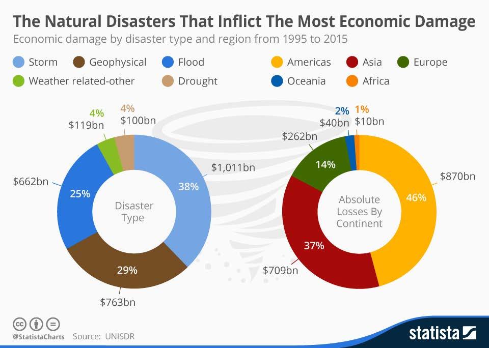
8 8
9 FLOODS - #1 US HAZARD Average flood claim amounts from were $42, , total flood insurance claims averaged more than $3.5 billion per year Statistics from 9
10 MITIGATION OF RISK 10

11 NATURAL HAZARD MITIGATION SAVES: AN INDEPENDENT STUDY TO ASSESS THE FUTURE SAVINGS FROM MITIGATION ACTIVITIES (2005) Money spent on reducing the risk of natural hazards is a sound investment. On average, a dollar spent by FEMA on hazard mitigation provides the nation about $4 in future benefits. 11


12 A VALUABLE CONTRIBUTION... BUT QUESTIONS REMAINED Private Sector Initiatives Lifelines Building Codes 12


13 13
14 NATURAL HAZARD MITIGATION SAVES: 2017 INTERIM REPORT FINDINGS Federal grants: The impacts of 23 years of federal mitigation grants provided by the Federal Emergency Management Agency (FEMA), Economic Development Administration (EDA) and Department of Housing and Urban Development (HUD), resulting in a national benefit of $6 for every $1 invested. Exceed code requirements: The costs and benefits of designing all new construction to exceed select provisions in the 2015 International Building Code (IBC) and the 2015 International Residential Code (IRC) and the implementation of the 2015 International Wildland-Urban Interface Code (IWUIC). This resulted in a national benefit of $4 for every $1 invested. 14

15 BENEFIT COST RATIOS BY HAZARD AND MITIGATION MEASURE 15
16 FROM MAPS TO ACTION USING GIS AND MODELING TO INCREASE COMMUNITY RESILIENCY 16
17 MOVING FROM MAPS TO ACTIONS Trend toward GIS-informed websites and tools that offer actionable information (rather than just information) New technologies are leveraging: Models Dynamic visualization Ability to link information to decision making 17

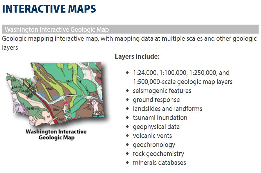


18 WASHINGTON GEOLOGICAL SURVEY 18

19 WASHINGTON GEOLOGICAL SURVEY 19

20 WASHINGTON GEOLOGICAL SURVEY 20

21 NORTH CAROLINA 21


22 NC INTEGRATED HAZARD RISK MANAGEMENT PROGRAM 22


23 23


24 24

25 FEMA S NATIONAL RISK INDEX 25
26 NRI GOALS DEVELOP a Nationwide Risk Index for Natural Hazards To include a national set of hazard-specific risk indices To be used independently or combined to create a multi-hazard index To represent an indicator of risk leveraging existing baselines and datasets as much as possible To create an interactive online viewer that will allow the user to: Focus on a defined geographic region Export tabular and geospatial results for each hazard Generate maps and reports compatible with mitigation plans 26
27 NRI GOALS ENHANCE FEMA Initiatives To inform regional project prioritization, resource allocation, mitigation/land use planning, and community engagement strategies across FEMA SUPPORT National Stakeholders To incorporate the data into State Business Plans and State and Local Hazard Mitigation Plans To inform the Areas of Mitigation Interest 27

28 NRI FACTORS 28

29 NRI DEVELOPMENT CYCLE (2016 TO RELEASE SUMMER 2018) 29

30 30

31 31
32 AFTER DISASTER STRIKES 32
33 UTILIZATION OF GIS FOR DAMAGE ASSESSMENT Hurricane Matthew first major hurricane to hit landfall in Florida in over 10 years Paralleled the Florida Georgia Coast Came ashore on October 7, 2016 Caused damage and flooding in Florida, Georgia, South and North Carolina 33


34 PRE-PLAN TRAINING AND SOFTWARE APPLICATIONS Utilization of cloud-based Web Apps to speed process of damage assessment Integration of local government data, from GIS to Assessors info Example software: IDAM Fulcrum Emergency Management Apps State level applications Indiana CrisisTrack FEMA App 34
35 INTO THE FUTURE 35


36 ENCOURAGING ACTION Awareness of risk alone is not often sufficient to encourage action. Incentives are needed Policy Financial 36


37 AVOID THE 10,000 FOOT APPROACH One size fits all? Source: Esri Digital Globe GeoEye, Earthstar Geographics CNES Airbus DS USDA USGS AeroGRID IGN and the GIS User Community 37


38 BETWEEN THEORY & PRACTICE We d like to think we are managing risks like this: 38
39 IFRM BETWEEN THEORY & PRACTICE In reality the status quo is more like this: Damage Assessment Plan Recovery Warning Rescue Preparedness 39
")

40 PLATFORM (NOT PORTAL) THINKING South Carolina CHAMPS Others? 40
41 THANKS! 41
Federal Grants Provide $6 Benefit for Each $1 Invested
 Federal Grants Provide $6 Benefit for Each $1 Invested Introduction Natural hazards present significant risks to many communities across the United States. Fortunately, there are measures governments,
Mike Waters VP Risk Decision Services Bob Shoemaker Sr. Technical Coordinator. Insurance Services Office, Inc
 Mike Waters VP Risk Decision Services Bob Shoemaker Sr. Technical Coordinator Insurance Services Office, Inc Disasters Large and Small A Convergence of Interests Public and Private ESRI Homeland Security
AGENDA. Floodplain Manager s Toolkit Unlocking the Hidden Potential of Floodplain Data for Your Community
 Floodplain Manager s Toolkit Unlocking the Hidden Potential of Floodplain Data for Your Community TFMA Spring Conference May 29, 2014 Jessica D. Baker, PE, CFM, PMP Samuel Amoako-Atta, GISP, CFM Eric Hajek,
Floodplain Manager s Toolkit Unlocking the Hidden Potential of Floodplain Data for Your Community
 Floodplain Manager s Toolkit Unlocking the Hidden Potential of Floodplain Data for Your Community TFMA South Central Lunch Event San Antonio, TX June 12, 2014 Jessica D. Baker, PE, CFM, PMP Samuel Amoako-Atta,
Natural Hazard Mitigation Saves:
 Natural Hazard Mitigation Saves: 2018 Interim Report Summary of Findings BCRs for Mitigation Strategies Studied (from Highest to Lowest) Adopting Model Codes Saves $11 per $1 Spent Federal Mitigation Grants
Preliminary Work Map Release
 Coastal Mapping in New Jersey Preliminary Work Map Release Monmouth County, New Jersey June 14, 2013 Agenda Introduction and Purpose of Briefing Hurricane Sandy Advisory Base Flood Elevations Transitioning
Natural Hazard Mitigation Saves: 2017 Interim Report
 National Institute of BUILDING SCIENCES Summary of Findings Natural Hazard Mitigation Saves: 2017 Interim Report An Authoritative Source of Innovative Solutions for the Built Environment NOTICE: The results
GEO CODING IN NAT CAT UNDERWRITING. 2. Part I: CRESTA in NAT Cat Underwriting. 3. Part II: NATHAN in NAT Cat Underwriting
 GEO CODING IN NAT CAT UNDERWRITING 5th ICRM Roundtable Matti Siitonen / Munich Re (Singapore Branch) Singapore, 28 February 2014 Agenda 1. Introduction to Geo Coding: - Where are we today? - Principles
Garfield County NHMP:
 Garfield County NHMP: Introduction and Summary Hazard Identification and Risk Assessment DRAFT AUG2010 Risk assessments provide information about the geographic areas where the hazards may occur, the value
FEMA Leverages Building Codes and Standards to Advance Resiliency
 FEMA Leverages Building Codes and Standards to Advance Resiliency The goal of emergency management policy should be not just to respond but also to change the outcomes of natural hazards, and to do that,
Flood Insurance Coverage in Dare County: Before and After Hurricane Floyd
 Flood Insurance Coverage in Dare County: Before and After Hurricane Floyd Craig E. Landry Department of Economics Center for Natural Hazards Research East Carolina University National Flood Insurance Program
Natural Hazard Mitigation Saves: 2017 Interim Report
 National Institute of BUILDING SCIENCES Natural Hazard Mitigation Saves: 2017 Interim Report An Authoritative Source of Innovative Solutions for the Built Environment NOTICE: The results presented here
1.1.1 Purpose. 1.2 Background and Scope
 1.1.1 Purpose Van Buren County and the 8 associated jurisdictions and associated agencies, business interests and partners of the county prepared this local hazard mitigation plan to guide hazard mitigation
Mark Brannon, FCAS, MAAA, CPCU Sue Buehler, FCAS, MAAA
 P&C Catastrophe Issues Mark Brannon, FCAS, MAAA, CPCU Sue Buehler, FCAS, MAAA Association of Insurance Compliance Professionals Gulf States Chapter Education Day July 30, 2010 Atlanta, Georgia Agenda What
G318 Local Mitigation Planning Workshop. Module 2: Risk Assessment. Visual 2.0
 G318 Local Mitigation Planning Workshop Module 2: Risk Assessment Visual 2.0 Unit 1 Risk Assessment Visual 2.1 Risk Assessment Process that collects information and assigns values to risks to: Identify
Mitigation Success Publications
 The following publications are a sample of the many and varied documents that have been produced by States, associations and communities. MULTI-HAZARDS FEMA 294 Report on Costs and Benefits of Natural
September Three Steps for Implementing a Complete Flood Management Plan
 September 2016 Three Steps for Implementing a Complete Flood Management Plan Copyright 2016 Esri All rights reserved. Printed in the United States of America. The information contained in this document
Northern Kentucky University 2018 Hazard Mitigation Plan. Public Kick-Off Meeting March 20, 2018
 Northern Kentucky University 2018 Hazard Mitigation Plan Public Kick-Off Meeting March 20, 2018 Agenda Welcome Hazard Mitigation Planning 101 Hazard Identification Exercises Next Steps Jeff Baker, NKU
SOUTH CENTRAL REGION MULTI-JURISDICTION HAZARD MITIGATION PLAN. Advisory Committee Meeting September 12, 2012
 SOUTH CENTRAL REGION MULTI-JURISDICTION HAZARD MITIGATION PLAN Advisory Committee Meeting September 12, 2012 AGENDA FOR TODAY Purpose of Meeting Engage All Advisory Committee Members Distribute Project
A Multihazard Approach to Building Safety: Using FEMA Publication 452 as a Mitigation Tool
 Mila Kennett Architect/Manager Risk Management Series Risk Reduction Branch FEMA/Department of Homeland Security MCEER Conference, September 18, 2007, New York City A Multihazard Approach to Building Safety:
Project Information. SHARS Number: (Name and Title) Tarrytown, NY Telephone:
 Tarrytown, NY Telephone:") Environmental Review for Activity/Project that is Exempt or Categorically Excluded Not Subject to Section 58.5 Pursuant to 24 CFR Part 58.34(a) and 58.35(b) Project Information Program Name: Opening Doors
Environmental Review for Activity/Project that is Exempt or Categorically Excluded Not Subject to Section 58.5 Pursuant to 24 CFR Part 58.34(a) and 58.35(b) Project Information Program Name: Opening Doors
David A. Stroud, CFM AMEC Earth & Environmental Raleigh, NC
 David A. Stroud, CFM AMEC Earth & Environmental Raleigh, NC Objectives Risk MAP background North Carolina s Risk MAP role Role of communication in Risk MAP Effective risk communication two examples Multi-hazard
Hazard Mitigation FAQ
 Hazard Mitigation FAQ What is Hazard Mitigation? Actions taken to reduce or eliminate the long-term risk to people, property, or the environment from hazards and their effects. Examples: Hazardous Area
Kentucky Risk MAP It s not Map Mod II
 Kentucky Risk MAP It s not Map Mod II Risk Mapping Assessment and Planning Carey Johnson Kentucky Division of Water carey.johnson@ky.gov What is Risk MAP? Risk Mapping, Assessment, and Planning (Risk MAP)
Neighborhood Housing Services of Queens, CDC. Heather Spitzberg, Director, Environmental Analysis Unit
 Environmental Review for Activity/Project that is Exempt or Categorically Excluded Not Subject to Section 58.5 Pursuant to 24 CFR Part 58.34(a) and 58.35(b) Project Information Program Name: NHSQ CDC HOME
BY BOB WOODS PLANNING TODAY FOR TOMORROW S TERRAY SYLVESTER / GETTY IMAGES
 BY BOB WOODS PLANNING TODAY FOR TOMORROW S TERRAY SYLVESTER / GETTY IMAGES As weather-related events such as hurricanes multiply and intensify, states and municipalities are recognizing the urgent need
Best Practices. for Incorporating Building Science Guidance into Community Risk MAP Implementation November 2012
 Best Practices for Incorporating Building Science Guidance into Community Risk MAP Implementation November 2012 Federal Emergency Management Agency Department of Homeland Security 500 C Street, SW Washington,
Flood Risk Outreach Tools for Georgia Communities. GAFM 10 th Annual Conference Presented By: Jarrett Mattli
 Flood Risk Outreach Tools for Georgia Communities GAFM 10 th Annual Conference Presented By: Jarrett Mattli April 13, 2016 Presentation Overview Guidebooks Toolkits Templates Educational Videos Resource
RESILIENT INFRASTRUCTURE June 1 4, 2016
 RESILIENT INFRASTRUCTURE June 1 4, 2016 MUNICIPAL RISK ASSESSMENT TOOL (MRAT) Scott Praill Dillon Consulting Limited, Canada ABSTRACT MRAT is a made-in-canada tool that overlays municipal data sets and
Attachment B. King County Flood Control Zone District Work Program
 Attachment B King County Flood Control Zone District Work Program The King County Flood Control Zone District work program is comprised of two major categories: Programmatic Work Program o Flood Preparedness,
FLOODPLAIN MANAGEMENT PLAN 2015 ANNUAL PROGRESS REPORT
 FLOODPLAIN MANAGEMENT PLAN 2015 ANNUAL PROGRESS REPORT Hinds County (Unincorporated) NFIP Community Number 280070 The 2015 Floodplain Management Plan Annual Progress Report on the progress made in implementing
TERREBONNE PARISH HAZARD MITIGATION PLAN UPDATE
 TERREBONNE PARISH HAZARD MITIGATION PLAN UPDATE HAZARD MITIGATION PLAN UPDATE COMMITTEE KICK-OFF MEETING May 22, 2014 A World of Solutions 0 PRESENTATION AGENDA I. INTRODUCTIONS AND WELCOME II. PURPOSE,
Wildfire and Flood Hazards, Using GIS Tools to Assess Risk
 Wildfire and Flood Hazards, Using GIS Tools to Assess Risk Floodplain Management Association Conference, Rancho Mirage, CA September 2015 Thoughts To Keep In Mind What advantages are there in looking at
Risk-based Land-use Guide: Safe use of land based on hazard risk management
 Risk-based Land-use Guide: Safe use of land based on hazard risk management Bert Struik, Laurie Pearce Calgary, September 29, 2015 Messages A city-focused land-use guide is available to help reduce risk
Role of Disaster Insurance in Improving Resilience: An Expert Meeting The Resilient America Roundtable
 Role of Disaster Insurance in Improving Resilience: An Expert Meeting The Resilient America Roundtable National Academy of Science Washington, DC July 9, 2015 Roseville Demographics Primary population
INTERLOCAL AGREEMENT FOR USE OF OPEN SPACE PLAYING FIELD AND AMENITIES AT HERON CREEK MIDDLE SCHOOL
 INTERLOCAL AGREEMENT FOR USE OF OPEN SPACE PLAYING FIELD AND AMENITIES AT HERON CREEK MIDDLE SCHOOL THIS INTERLOCAL AGREEMENT (the Agreement ) is made and entered into by and between the School Board of
Changes to the National Flood Insurance Program What to Expect
 Changes to the National Flood Insurance Program What to Expect Impact of changes to the NFIP under Homeowner Flood Insurance Affordability Act of 2014 and Biggert-Waters 12 October 2014 Key Priorities
Launch a Vulnerability Assessment. Building Regional Disaster Resilience
 Launch a Vulnerability Assessment Building Regional Disaster Resilience Overall Process Building Regional Disaster Resilience How is this process different? Goals and values-driven rather than checklist-driven
Use of FEMA Non regulatory Flood Risk Products in Planning
 Use of FEMA Non regulatory Flood Risk Products in Planning Georgia Association of Floodplain Managers Annual Conference March 24, 2016 What are the Non regulatory Flood Risk products? Go beyond the basic
Overview of HAZUS. December 6, 2011
 Overview of HAZUS December 6, 2011 What is HAZUS? Risk assessment tool for analyzing potential losses from hurricane, flood, and earthquake Uses current scientific and engineering concepts in a GIS to
The LiDAR Program in Missouri Branson LiDAR Workshop. Ray Fox Geospatial Liaison to Missouri Chair, MGISAC Data Development
 The LiDAR Program in Missouri Branson LiDAR Workshop Ray Fox Geospatial Liaison to Missouri Chair, MGISAC Data Development Outline Data Development Committee Lidar Stakeholders Group National Elevation
GAFM Showcase: Multiple Agencies Combating Georgia s Flood Risk Together: Proven Results Gained by Strong Partnerships
 National Flood Insurance Program Participation GAFM Showcase: Multiple Agencies Combating Georgia s Flood Risk Together: Proven Results Gained by Strong Partnerships Moderator: Jill Bazinet, PE, CFM GAFM
Michael Taylor, PE, CFM Project Manager, AECOM August 25, 2015
 Promoting FEMA s Flood Risk Products in the Lower Levisa Watershed Michael Taylor, PE, CFM Project Manager, AECOM August 25, 2015 Agenda Study Background Flood Risk Product Overview AOMI and Mitigation
Suwannee River Water Management District
 Suwannee River Water Management District FEMA Flood Map Modernization Program 5-Year Business Plan FY 2004-2009 Prepared By: URS Corporation Dewberry Water Resource Associates February 14, 2004 Revised
Flood Hazard Demographics and NFIP Policy/Claims Analysis
 Flood Hazard Demographics and NFIP Policy/Claims Analysis ASFPM - Hartford, CT June 2013 Mohan Rajasekar Mark Crowell Andy Neal Problem Statement NFIP A means of discouraging unwise occupancy of flood
Flooding and the Public: Experiences from SC flooding events in 2015 and 2016
 Flooding and the Public: Experiences from SC flooding events in 2015 and 2016 Maria Cox Lamm, CFM State Coordinator SCDNR Flood Mitigation Program www.dnr.sc.gov/flood Public Reaction to Flooding Would
RUTHANNE VISNAUSKAS Commissioner/CEO
 ANDREW M. CUOMO Governor RUTHANNE VISNAUSKAS Commissioner/CEO July 5, 2017 VIA ELECTRONIC Ms. Veronia Rosas, Administrative Assistant Bronx Neighborhood Housing Services CDC, Inc. 1451 E. Gun Hill Road
The Changing NFIP, the CRS & Local Governments. Scott Pippin, J.D., M.E.P.D.
 The Changing NFIP, the CRS & Local Governments Scott Pippin, J.D., M.E.P.D. Flood Insurance Reform Biggert Waters 2012 (BW12) Homeowner Flood Insurance Affordability Act of 2014 (HFIAA) Bigger Waters 2012
Overview of HAZUS for Earthquake Loss Estimation. September 6, 2012
 Overview of HAZUS for Earthquake Loss Estimation September 6, 2012 What is HAZUS? Risk assessment tool for analyzing potential losses from hurricane, flood, and earthquake Uses current scientific and engineering
Title of Nomination: Flood Plain Mapping Project/System Manager: John Dorman. Center for Geographic Information Analysis Department: Address:
 Title of Nomination: Flood Plain Mapping Project/System Manager: John Dorman Job Title: Project Manager Agency: Center for Geographic Information Analysis Department: Address: City: Raleigh State: NC Zip:
New Tools for Mitigation & Outreach. Louie Greenwell Stantec
 New Tools for Mitigation & Outreach Louie Greenwell Stantec Our Discussion Today Background What is Risk MAP? FEMA Products Overview of RiskMAP Data Sets Changes Since Last FIRM Depth and Analysis Grids
Modernization, FEMA is Recognizing the connection between damage reduction and
 EXECUTIVE SUMMARY Every year, devastating floods impact the Nation by taking lives and damaging homes, businesses, public infrastructure, and other property. This damage could be reduced significantly
Effective Flood Risk Assessment Methodologies
 Flood Risk Management and Urban Resilience Workshop II May 28-29, 2013 Venue: COEX, Seoul, Republic of Korea Effective Flood Risk Assessment Methodologies National Disaster Management Institute, NDMI Tae
Section 19: Basin-Wide Mitigation Action Plans
 Section 19: Basin-Wide Mitigation Action Plans Contents Introduction...19-1 Texas Colorado River Floodplain Coalition Mitigation Actions...19-2 Mitigation Actions...19-9 Introduction This Mitigation Plan,
Pennsylvania. Senate Banking & Insurance and Senate Environmental Resources & Energy Committees. Joint Public Hearing on Flood Insurance
 Pennsylvania Senate Banking & Insurance and Senate Environmental Resources & Energy Committees Joint Public Hearing on Flood Insurance January 28, 2014 Respectfully submitted by: Donald L. Griffin, CPCU,
Hazard Mitigation Planning
 Hazard Mitigation Planning Mitigation In order to develop an effective mitigation plan for your facility, residents and staff, one must understand several factors. The first factor is geography. Is your
Section 2. Introduction and Purpose of the LMS
 Section 2. Introduction and Purpose of the LMS 2.1 Introduction The Disaster Mitigation Act of 2000 (DMA 2000), signed into law by the President of the United States on October 30, 2000 (P.L. 106-390),
Updates to Maine Coastal Flood Insurance Rate Maps (FIRM s): What a Local Official Should Know. Presented by: Steve Johnson, P.E.
: What a Local Official Should Know. Presented by: Steve Johnson, P.E.") Updates to Maine Coastal Flood Insurance Rate Maps (FIRM s): What a Local Official Should Know Presented by: Steve Johnson, P.E. Town Engineer October 4, 2018 Introduction Federal Emergency Management
Updates to Maine Coastal Flood Insurance Rate Maps (FIRM s): What a Local Official Should Know Presented by: Steve Johnson, P.E. Town Engineer October 4, 2018 Introduction Federal Emergency Management
Hazard Mitigation Plan Chapter Annex
 Hazard Mitigation Plan Chapter Annex Contact Information Primary Point of Contact Name: Title: Address: Phone Number: E-mail: Alternate Point of Contact Name: Title: Address: Phone Number: E-mail: Reporting
Minutes. ADA Self-Evaluation & Transition Plan (SETP) Project Status; Christine Calabrese, City ADA Coordinator
 Project Status; Christine Calabrese, City ADA Coordinator") City of Oakland Mayor's Commission on Persons with Disabilities (MCPD) Special Ad Hoc Committee Meeting on the Self-Evaluation and Transition Plan Update Monday, October 2, 2017 I. Call to Order: 5:30
City of Oakland Mayor's Commission on Persons with Disabilities (MCPD) Special Ad Hoc Committee Meeting on the Self-Evaluation and Transition Plan Update Monday, October 2, 2017 I. Call to Order: 5:30
February 18, 2005 NFIP-NCEM 5-Year CAP Plan, Sections I-III Page 1 of 6
 State of North Carolina Division of Emergency Management Floodplain Management Branch Community Assistance Program/State Support Services Element (CAP/SSSE) National Flood Insurance Program Five Year Work
Federal Emergency Management Agency Update. Jesse F. Munoz, CEM Director Mitigation Division Region IV
 Federal Emergency Management Agency Update Jesse F. Munoz, CEM Director Mitigation Division Region IV To support our citizens and first responders to ensure that as a nation we work together to build,
3DEP Coalition Meeting. Kevin T. Gallagher Associate Director, Core Science Systems November 10, 2016
 + 3DEP Coalition Meeting Kevin T. Gallagher Associate Director, Core Science Systems November 10, 2016 + 2 3DEP Status 2023 + 3 3D Elevation Program (3DEP) Mission Critical Applications Geologic Hazards
Flood Risk Assessment in the
 Georgia Flood M.A.P. Program Flood Risk Assessment in the Upper Chattahoochee h h River Basin GAFM Annual Conference March 28, 2012 Agenda Map Mod to Risk MAP (Georgia Flood M.A.P.) transition Flood Risk
Location: Tampa, Florida March 6, 2013
 Discovery Meeting: West Florida Coastal Study Location: Tampa, Florida March 6, 2013 Agenda Introductions Why we are here Outline Risk MAP products and datasets Discovery Overview: Project scoping and
DAVIDSON, UDEL DHS Coastal Resilience Center Research Project: Annual Project Performance Report Covers reporting period January 1, 2016 June 30, 2016
 DAVIDSON, UDEL DHS Coastal Resilience Center Research Project: Annual Project Performance Report Covers reporting period January 1, 2016 June 30, 2016 1. Project Title: An Interdisciplinary Approach to
Establishing a Deductible for FEMA s Public Assistance Program, FEMA
 Jotham Allen Federal Emergency Management Agency 500 C Street, S.W. Washington, DC 20472 RE: Establishing a Deductible for FEMA s Public Assistance Program, FEMA-2016-0003 Dear Mr. Allen: The National
Kyrgyz Republic. Measuring Seismic Risk {P149630} Public Disclosure Authorized. Report No: AUS Public Disclosure Authorized.
 Public Disclosure Authorized Report No: AUS0000061 Kyrgyz Republic Public Disclosure Authorized Public Disclosure Authorized Measuring Seismic Risk {P149630} {December, 2017} URS Public Disclosure Authorized
FEMA s Flood Map Modernization Preparing for FY09 and Beyond: Integrated Flood Data Update, Risk Assessment, and Mitigation Planning
 FEMA s Flood Map Modernization Preparing for FY09 and Beyond: Integrated Flood Data Update, Risk Assessment, and Mitigation Planning DRAFT CONCEPT PAPER June 1, 2007 Integrated Flood Data Update, Risk
There is no linear, straight line that the development of Boston took from the time of the Pilgrims to now.
 Close your eyes There is no linear, straight line that the development of Boston took from the time of the Pilgrims to now. Sustainability Sustainable development is a moving target. It represents a continuous
ASFPM REGION 6 DIRECTOR ANNUAL REPORT. Annual Conference-Atlanta, Georgia
 ASFPM REGION 6 DIRECTOR ANNUAL REPORT Annual Conference-Atlanta, Georgia Jessica Baker, Regional Director 5/31/2015 ASFPM REGION 6 DIRECTOR ANNUAL REPORT Annual Conference-Atlanta, Georgia Region 6 Report
Flood Risk Resilience in Alabama: Challenges and Successes
 Flood Risk Resilience in Alabama: Challenges and Successes Leslie A. Durham, P.E. Floodplain Management Branch Chief Alabama Office of Water Resources 10 Year Partnership with FEMA Flood Map Modernization
SILVER JACKETS: TEAMING TO MITIGATE AND MANAGE STATE FLOOD HAZARD PRIORITIES
 SILVER JACKETS: TEAMING TO MITIGATE AND MANAGE STATE FLOOD 255 255 255 237 237 237 0 0 0 217 217 217 163 163 163 200 200 200 131 132 122 239 65 53 80 119 27 HAZARD PRIORITIES 110 135 120 252 174.59 112
VULNERABILITY ASSESSMENT
 SOUTHSIDE HAMPTON ROADS HAZARD MITIGATION PLAN VULNERABILITY ASSESSMENT INTRODUCTION The Vulnerability Assessment section builds upon the information provided in the Hazard Identification and Analysis
Discovery Meeting: Middle Potomac- Catoctin Watershed. FEMA REGION III September 26, 2012 Rockville, MD and Fairfax, VA
 Discovery Meeting: Middle Potomac- Catoctin Watershed FEMA REGION III September 26, 2012 Rockville, MD and Fairfax, VA Agenda Introductions Purpose of This Meeting Discovery Process Community Rating System
BRANDI GABBARD CHAIR, NATIONAL ASSOCIATION OF REALTORS INSURANCE COMMITTEE COUNCIL MEMBER, CITY OF ST. PETERSBURG, FL
 BUILDING CLIMATE RESILIENCE IN THE REAL ESTATE SECTOR BRANDI GABBARD CHAIR, NATIONAL ASSOCIATION OF REALTORS INSURANCE COMMITTEE COUNCIL MEMBER, CITY OF ST. PETERSBURG, FL RESILIENCY THE ABILITY TO PREPARE
School District Mitigation Planning 101 April 28 th 30 th 2014
 School District Mitigation Planning 101 April 28 th 30 th 2014 Kenneth A. Goettel Goettel & Associates Inc. 1732 Arena Drive Davis, CA 95618 (530) 750-0440 KenGoettel@aol.com What is Hazard Mitigation?
4 TH ANNUAL CAPE COASTAL CONFERENCE. Adaptation Planning, Environmental Economics and Community Engagement
 4 TH ANNUAL CAPE COASTAL CONFERENCE THE RESILIENT CAPE COD PROJECT Adaptation Planning, Environmental Economics and Community Engagement K r i s t y S e n a t o r i, Cape Cod Commission NOAA COASTAL RESILIENCY
NFIP Program Basics. KAMM Regional Training
 NFIP Program Basics KAMM Regional Training Floodplain 101 Homeowners insurance does not cover flood damage Approximately 25,000 flood insurance policies in KY According to BW12 analysis, approximately
Catastrophe Risk Engineering Solutions
 Catastrophe Risk Engineering Solutions Catastrophes, whether natural or man-made, can damage structures, disrupt process flows and supply chains, devastate a workforce, and financially cripple a company
LOCAL HAZARD MITIGATION PLAN UPDATE CHECKLIST
 D LOCAL HAZARD MITIGATION PLAN UPDATE CHECKLIST This section of the Plan includes a completed copy of the Local Hazard Mitigation Checklist as provided by the North Carolina Division of Emergency Management.
Geointelligence for your business
 NATHAN Risk Suite Geointelligence for your business Innovative Natural Hazards Assessment Network and services Check into NATHAN Risk Suite With the NATHAN (Natural Hazards Assessment Network) Risk Suite,
Disaster Mitigation. Kevin M. Simmons, Ph.D. Austin College. Fulbright Research Scholar International Centre for Geohazards Oslo, Norway
 Disaster Mitigation Kevin M. Simmons, Ph.D. Austin College Fulbright Research Scholar International Centre for Geohazards Oslo, Norway Economic and Societal Impacts of Tornadoes By Kevin M. Simmons and
Flood Risk Management and Nonstructural Flood Risk Adaptive Measures
 Flood Risk Management and Nonstructural Flood Risk Adaptive Measures Randall Behm, P.E., CFM USACE-Omaha District Chair, National Nonstructural Flood Proofing Committee US Army Corps of Engineers BUILDING
Flood Risk in the Schuylkill Watershed. Planning for Resilient Communities
 Flood Risk in the Schuylkill Watershed Planning for Resilient Communities Welcome to Our Poster Session! We are here to talk about: Flood Risk in the Schuylkill River Watershed Taking Action to Reduce
FLORIDA PROPERTY INSURANCE FACTS JANUARY 2008
 Dr. Robert P. Hartwig, CPCU President (212) 346-5520 bobh@iii.org FLORIDA PROPERTY INSURANCE FACTS JANUARY 2008 Hurricanes are More Likely to Hit Florida than any Other U.S. State 8 of the 10 most expensive
The Citadel. Multi-Hazard Mitigation Disaster Resistant University Plan
 The Citadel Multi-Hazard Mitigation Disaster Resistant University Plan Project Objective To Develop a Disaster Resistant University Hazard Mitigation Plan Identify Hazards Profile Hazards Inventory Assets
Leveraging HAZUS for Risk Assessment Analysis within Risk MAP
 Leveraging HAZUS for Risk Assessment Analysis within Risk MAP Jen Meyer - FEMA Region X Shane Parson - RAMPP PTS Team (URS Corp.) 2010 HAZUS Conference - August 2010 The Paradigm Shift: Map Mod to Risk
Sea Level Rise and the NFIP
 Cheryl A Johnson, PE, CFM, PMP March 26, 2014 http://www.globalchange.gov/ Sea-level rise and the likely increase in hurricane intensity and associated storm surge will be among the most serious consequences
National Coastal Outreach
 National Coastal Outreach Answering Tough Questions June 11, 2013 Why Focus on Coastal Flood Risk? 120,475,000 people or 39% of the U.S. population live in counties subject to the 1% annual chance coastal
Integrating Hazus into the Flood Risk Assessment
 Integrating Hazus into the Flood Risk Assessment GAFM Conference, March 22, 2016 Mapping Assessment Planning Agenda What is Hazus & Risk Assessment? Census Block vs. Site Specific Analysis User Defined
Region VIII Applications of Nationwide HAZUS Flood and Earthquake Modeling-Multi
 Region VIII Mitigation GIS Region VIII Applications of Nationwide HAZUS Flood and Earthquake Modeling-Multi Multi- Hazard Vulnerability Index 22 May 2009, EF-3 Tornado Forms in Northern Colorado http://www.allamericanpatriots.com/48747834_colorado-gov-ritter-issues-formal-disaster-declara
CHAPTER THREE Natural Hazard Mitigation Strategy
 CHAPTER THREE Natural Hazard Mitigation Strategy Chapter 3 Section All Sections Updates to Section Revised Natural Hazards Introduction and all Sections to change Natural Hazards Subcommittee to Committee.
Mapping Flood Risk in the Upper Fox River Basin:
 Mapping Flood Risk in the Upper Fox River Basin: Vulnerable Populations and Adverse Health Effects Presented by: Angelina Hanson STUDY AREA: Wisconsin's Upper Fox River Basin Total Population 139,309.
Flood Risk Review (FRR) Meeting. Cumberland County, Pennsylvania Carlisle, Pennsylvania December 5, 2016
 Meeting. Cumberland County, Pennsylvania Carlisle, Pennsylvania December 5, 2016") Flood Risk Review (FRR) Meeting Cumberland County, Pennsylvania Carlisle, Pennsylvania December 5, 2016 Why are we here today? The Flood Insurance Study (FIS) report and Flood Insurance Rate Maps (FIRMs)
Flood Risk Review (FRR) Meeting Cumberland County, Pennsylvania Carlisle, Pennsylvania December 5, 2016 Why are we here today? The Flood Insurance Study (FIS) report and Flood Insurance Rate Maps (FIRMs)
Economic Impact. Cindy Davis, Deputy Director, Division of Building & Fire Regulations Virginia Department of Housing and Community Development
 Economic Impact Cindy Davis, Deputy Director, Division of Building & Fire Regulations Virginia Department of Housing and Community Development Benefits Reduced energy costs Increased ability to withstand
The National Flood Insurance Program and Flood Insurance Rate Map for San Francisco. Presentation at Treasure Island Community Meeting
 The National Flood Insurance Program and Flood Insurance Rate Map for San Francisco Presentation at Treasure Island Community Meeting October 17, 2007 1 National Flood Insurance Program (NFIP) Overview
Page 1. Rebuilding after Hurricane Charley: A Look at which Homes Still Need Repairs
 Page 1 Rebuilding after Hurricane Charley: A Look at which Homes Still Need Repairs By: Lea Schlanger Mentor: Dr. Beverly Ward July 24, 2008 Page 2 Introduction: On August 13, 2004 (Friday the 13 th ),
WELCOME!! Please sign in on one of the attendance rosters
 Georgia Emergency Management Agency GEMAOffice of Homeland Security Jackson County Hazard Mitigation Plan Update Kickoff Meeting WELCOME!! Please sign in on one of the attendance rosters Brian Laughlin
Disaster Risk Reduction and Financing in the Pacific A Catastrophe Risk Information Platform Improves Planning and Preparedness
 Disaster Risk Reduction and Financing in the Pacific A Catastrophe Risk Information Platform Improves Planning and Preparedness Synopsis The Pacific Islands Countries (PICs) 1, with a combined population