Natural Hazard Mitigation Plan 5-Year Update Progress Report Chippewa County Taskforce Committee January 29, 2013
|
|
|
- Emmeline McBride
- 5 years ago
- Views:
Transcription

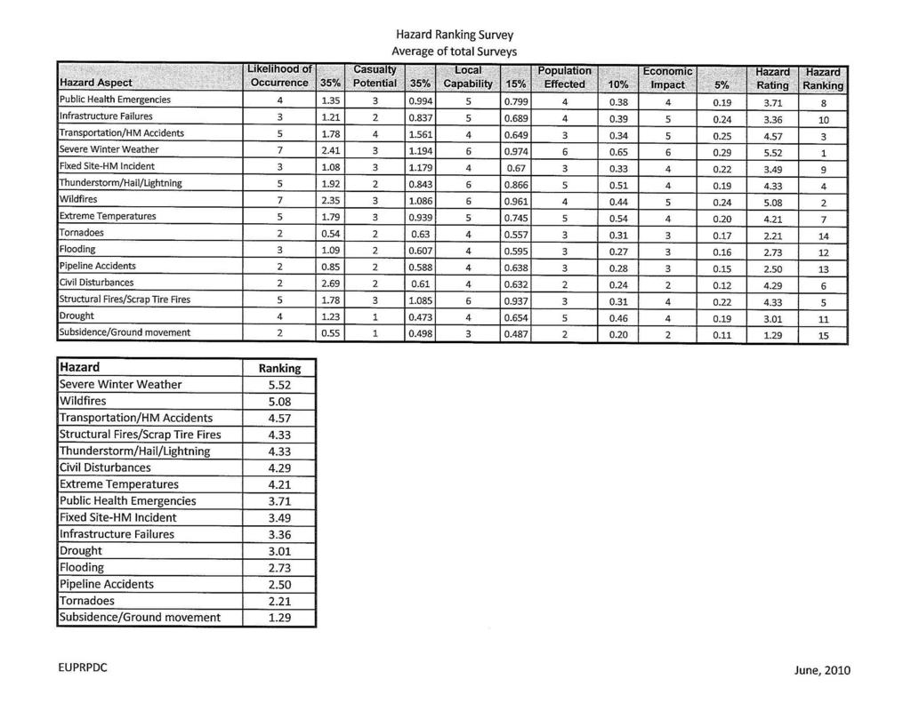
1 Natural Hazard Mitigation Plan 5-Year Update Progress Report Chippewa County Taskforce Committee January 29, 2013 Allegan County, June, 2010 Photo courtesy Peter Olson

2 Chapter Updates Chapter 1 Introduction» Purpose» Federal/State Requirements» Description of Emergency Management Cycle» Planning Approach» Public Participation» Background & Scope» Relationship to other Plans» Overview of Hazard Assessment
 Casualty Potential» Low = 1 3 points» Medium = 4 6 points» High = 7 10 points Little Italy,")
3 2005 Plan Update of Hazard Assessment Profile Methodology 1) Likelihood of Occurrence» Low = 1 3 points» Medium = 4 6 points» High = 7 10 points 2) Casualty Potential» Low = 1 3 points» Medium = 4 6 points» High = 7 10 points Little Italy, SSM
 1 3 points» Medium = (5% - 25% of population) 4 6 points» High = (more than 25% of population) 7 10 points 5) Economic Impact» Low = (less than $5,000) 1 3 points»")
4 Profile Methodology continued 2005 Plan 3) Local Capability» Low = (not very capable) 7 10 points» Medium = (somewhat capable) 4 6 points» High = (very capable) 1 3 points 4) Population Affected» Low = (less than 5% of population) 1 3 points» Medium = (5% - 25% of population) 4 6 points» High = (more than 25% of population) 7 10 points 5) Economic Impact» Low = (less than $5,000) 1 3 points» Medium = ($5,000 - $25,000) 4 6 points» High = (greater than $25,000) 7-10 points
5 2005 Plan Profile Methodology continued Since some criteria were considered more important than others each aspect was assigned a weight to balance the total score: Likelihood of Occurrence = 35% Casualty Potential = 35% Local Capability = 15% Population Affected = 10% Economic Impact = 5%
6 Profile Methodology 2012 Plan For Each Hazard: Hazard Description - a generic description of the hazard and associated problems, followed by details on the hazard specific to Chippewa County Geographic Extent Isolated: Single site occurrences for each incident (Points = 1) Limited: Less than 10 percent of the planning area (Points = 2) Significant: 10 to 50 percent of the planning area (Points = 3) Extensive: 50 to 100 percent of the planning area (Points = 4)
7 Profile Methodology continued 2012 Plan Historical Events - This subsection contains information on historic incidents, including impacts where known. The extent or location of the hazard within or near the Chippewa County Planning area is also included here. Likelihood of Occurrence Low less than a 1% chance of occurring annually (Points = 1) Medium 1% - 50% chance of occurring annually (Points = 2) High 51%-100% chance of occurring annually (Points = 3) Frequency is determined by dividing the number of events observed by the number of years and multiplying by 100. This gives the percent chance of event happening in any given year. Where this data results in a percent above 100 percent, the hazard is assumed to have a yearly frequency rating.

8 Profile Methodology continued 2012 Plan Direct Impacts - This describes the short-term consequences to people and property which occur directly as a result from the hazard. Indirect Impacts - This describes the short-term and long-term consequences, including social and economic impacts. Secondary hazards are also examined here.
9 Impact Magnitude and Severity Summary Population Affected Low (less than 5% of population) (Points = 1) Medium (5% - 25% of population) (Points = 2) High (more than 25% of the population affected) (Points = 3) Casualty Potential Low (no fatalities, treatable injuries) (Points = 1) Medium (fatalities possible, injuries probable) (Points = 2) High (fatalities, and/or life changing injuries probable) (Points = 3)
10 Impact Magnitude and Severity Summary continued Economic Impact Low (less than $5,000) (Points = 1) Medium ($5,000-$25,000) (Points = 2) High (greater than $25,000) (Points = 3) Local Capability Low (not very capable) (Points = 3) Medium (somewhat capable) (Points = 2) High (very capable) (Points = 1)
11 Vulnerability Assessment This section provides an analysis of the exposed properties, people and resources in the county specific to the hazard. For clarification and ease of mitigation planning, exposures are broken into four major categories: Population General Property Essential Infrastructure, Facilities, and Other Important Community Assets Natural, Historic and Cultural Resources

12 Estimating Potential Losses Potential losses will be determined based on available data, so the methodology varies by hazard. For some hazards this may be based on average annualized losses, or using the documented event of record for the hazard and identifying the corresponding damage in dollars, adjusting them for inflation to reflect 2012 costs. Where the hazard occurs in a specific area, such as flood, GIS methods will be used to estimate losses to structures and critical facilities, as available data permitted. Results of Duck Lake Fire, Luce County, 2012

13 Mitigation Capabilities Assessment A review of the existing mitigation activities and existing policies, regulations, and plans that pertain to mitigation and strategies that have been proven to be effective in reducing the risks and impact of a hazard.
14 Overall Risk Summary Overall vulnerability for the hazard is measured in terms of geographic extent, impacts, magnitude and severity, probability of occurrence, and exposure. These findings are summarized in this section and analyzed to reveal an overall risk rating for the hazard. This rating is calculated by averaging the numeric ratings for each measurement and then assigning a corresponding interpretation to the average. This determines the vulnerability of the County to the hazard, relative to the other hazards profiled. Low: Minor risk (0 to 1.9 average) Medium: Moderate risk (2.0 to 2.5 average) High: High risk. (2.5 or higher average)
15 Natural Hazards Severe Winter Weather/Heavy Snow/Blizzard/Ice Storms Severe Thunderstorms/High Wind Events/Hail/Lightning Wildfires Flooding Shoreline/Riverine/Dam Failures Drought Extreme Temperatures Tornados Subsidence Earthquakes
16 Man/Technological Hazards Infrastructure Failures Public Health Emergencies Transportation/Hazardous Materials Accidents Fixed Site Hazardous Materials Incident Civil Disturbances Pipeline Accidents Structural/Scrap Tire Fires
17 Chapter 2 Community Profile County Description Geography Climate Surface Waters Watershed Basins Population & Demographics Land Use Patterns Transportation Network Utilities Critical Facilities
18 Critical Facilities The law does not specify or define the term Critical Facility. The reason is this term should be defined by the planning process. Each planning effort should identify and define those facilities and infrastructure that are critical to providing emergency services to the planning area. These definitions can and should be unique to the defined planning area Plan Critical Facilities Hazard Materials Sites Health Facilities Hospitals/Nursing Homes Emergency Response Facilities Police & Fire Stations, Public Works sites Utilities Water & Wastewater Treatment plants, Electrical Substations Schools Places of Assembly host over 1,000 people Casino/Campground/Festivals Transportation Harbors, Ferries, Railroad, Airports, Bridges, Dams
19 2012 Critical Facilities Do we want to update the Critical Facilities definition for the 2012 Plan?
20 Public Input Surveys: 2010 Survey Local Units of Governments Supervisors Clerks Transportation DPW OES Board/Stakeholder s List Emergency First Responders
21 Responses Returned: 5 - LUG 12 - OES Board 14 - Firefighters
22
23 Public Input 2012 General Public On-Line Survey & Map Editing Tool To gather information from the general public and to assist in pinpointing areas on a map that are vulnerable to hazards. News release to local newspapers Facebook announcement blast/website/newsletter
24 Other Chapters Chapter 3 Detailed Hazards Profiles Chapter 4 Goals & Strategies Chapter 5 Action Plan Chapter 6 Implementation & Monitoring Appendixes List of Stakeholders/Committee Proof of Public Participation Survey & Survey Results Participating Local Units of Government s Documentation of Adoption 24
25 Mitigation Examples Land use planning Identifying hazard-prone areas Carefully plan development Acquisition Flood buy-out programs Tornado/High Wind safe rooms and warning systems Education and outreach Hazard maps, brochures, web site information
26 Next Steps Public Input Period/Public Meeting(s) to go over the results of on-line survey, map input, gather more input, and progress to date Goals & Strategies Developed by Taskforce Committee Draft Completed July, 2013 Series of Public Meetings Final Plan Update and approval by MSP/FEMA due September, 2013 Must be formally readopted Local governments School districts Colleges and universities» Any public entity who thinks it may want to secure hazard mitigation funding
] January 22, 2013 Questions?")
27 [Source: NASA's Moderate Resolution Imaging Spectroradiometer (MODIS)] January 22, 2013 Questions? Thank You
G318 Local Mitigation Planning Workshop. Module 2: Risk Assessment. Visual 2.0
 G318 Local Mitigation Planning Workshop Module 2: Risk Assessment Visual 2.0 Unit 1 Risk Assessment Visual 2.1 Risk Assessment Process that collects information and assigns values to risks to: Identify
1 Rare Hazard event is not likely to occur within 100 years. 2 Occasional Hazard event is likely to occur within 100 years
 5.3 HAZARD RANKING After the hazards of concern were identified for Onondaga County, the hazards were ranked to describe their probability of occurrence and their impact on population, property (general
Table Numerical Values and Definitions for Impacts on Population, Property and Economy
 5.3 Hazard Ranking After the hazards of concern were identified for Chenango County, the hazards were ranked to describe their probability of occurrence and their impact on population, property (general
Section II: Vulnerability Assessment and Mitigation
 Section II: Vulnerability Assessment and Mitigation 1. Hazard Vulnerability Analysis (facility name) should conduct a thorough Hazard Vulnerability Analysis to help determine what events or incidents may
Table presents the numerical rating, weighted factor and description for each impact category
 5.3 HAZARD RANKING After the hazards of concern were identified for Dutchess County, the hazards were ranked to describe their probability of occurrence and their impact on population, property (general
SOUTH CENTRAL REGION MULTI-JURISDICTION HAZARD MITIGATION PLAN. Advisory Committee Meeting September 12, 2012
 SOUTH CENTRAL REGION MULTI-JURISDICTION HAZARD MITIGATION PLAN Advisory Committee Meeting September 12, 2012 AGENDA FOR TODAY Purpose of Meeting Engage All Advisory Committee Members Distribute Project
in coordination with Peoria County, Planning and Zoning Department
 Prepared by Amec Foster Wheeler Environment & Infrastructure Hazard Mitigation and Emergency Management Program in coordination with Peoria County, Planning and Zoning Department The purpose of hazard
Multi-Jurisdictional Hazard Mitigation Plan. Data Collection Questionnaire. For School Districts and Educational Institutions
 Multi-Jurisdictional Hazard Mitigation Plan Data Collection Questionnaire For School Districts and Educational Institutions County: School District / Educational Institution Name: Return by: Please complete
T-318. Hazard Mitigation Section TDEM Recovery, Mitigation, and Standards
 T-318 Local Hazard Mitigation Plan Requirements Hazard Mitigation Section TDEM Recovery, Mitigation, and Standards Raymond Mejia, Lead Hazard Mitigation Planner Samantha Aburto, Hazard Mitigation Planner
Town of Montrose Annex
 Town of Montrose Annex Community Profile The Town of Montrose is located in the Southwest quadrant of the County, east of the Town of Primrose, south of the Town of Verona, and west of the Town of Oregon.
Multi-Jurisdictional Hazard Mitigation Plan. Data Collection Questionnaire. For Local Governments
 Multi-Jurisdictional Hazard Mitigation Plan Data Collection Questionnaire County: For Local Governments Jurisdiction: Return to: Marcus Norden, Regional Planner BRP&EC Please complete this data collection
APPENDIX D PLANNING PROCESS DOCUMENTATION
 APPENDIX D PLANNING PROCESS DOCUMENTATION This appendix includes the following: 1. Meeting Agendas 2. Meeting Minutes 3. Meeting Sign-In Sheets 4. Public Survey Summary Results 1) Introductions AGENDA
Garfield County NHMP:
 Garfield County NHMP: Introduction and Summary Hazard Identification and Risk Assessment DRAFT AUG2010 Risk assessments provide information about the geographic areas where the hazards may occur, the value
Northern Kentucky University 2018 Hazard Mitigation Plan. Public Kick-Off Meeting March 20, 2018
 Northern Kentucky University 2018 Hazard Mitigation Plan Public Kick-Off Meeting March 20, 2018 Agenda Welcome Hazard Mitigation Planning 101 Hazard Identification Exercises Next Steps Jeff Baker, NKU
Village of Blue Mounds Annex
 Village of Blue Mounds Annex Community Profile The Village of Blue Mounds is located in the southwest quadrant of the County, north of the town of Perry, west of the town of Springdale, and south of the
Lake County Hazard Identification and Risk Assessment Plan Lake County Hazard Mitigation Committee
 Lake County Hazard Identification and Risk Assessment Plan Lake County Hazard Mitigation Committee Request for Proposals Bid Deadline: Hard Copy Due 4:00 PM Mountain Standard Time (MST) Friday March 9,
Southwest Florida Healthcare Coalition
 Southwest Florida Healthcare Coalition Hazards Vulnerability Assessment 2018 1 Table of Contents Summary 3 EmPower Maps and Data 5 Social Vulnerability Index Maps 19 Suncoast Disaster Healthcare Coalition
Tangipahoa Parish Hazard Mitigation Plan Update Mitigation Steering Committee Kick-off Meeting. September 9, 2014 Hammond, LA
 Tangipahoa Parish Hazard Mitigation Plan Update Mitigation Steering Committee Kick-off Meeting September 9, 2014 Hammond, LA Introductions Officials Mitigation Steering Committee members SDMI team members
5.3 HAZARD RANKING HAZARD RANKING METHODOLOGY
 5.3 HAZARD RANKING After the hazards of concern were identified for Burlington County, the hazards were ranked to describe their probability of occurrence and their impact on population, property (general
Evaluate every potential event in each of the three categories of probability, risk, and preparedness. Add additional events as necessary.
 HAZARD VULNERABILITY ANALYSIS The Joint Commission defines hazard vulnerability analysis as the identification of hazards and the direct and indirect effect these hazards may have on the hospital. Hazard
Modeling Extreme Event Risk
 Modeling Extreme Event Risk Both natural catastrophes earthquakes, hurricanes, tornadoes, and floods and man-made disasters, including terrorism and extreme casualty events, can jeopardize the financial
ANNEX B: TOWN OF BLUE RIVER
 ANNEX B: TOWN OF BLUE RIVER B.1 Community Profile Figure B.1 shows a map of the Town of Blue River and its location within Summit County. Figure B.1. Map of Blue River Summit County (Blue River) Annex
Natural Hazards Mitigation Plan Kankakee County, Illinois Executive Summary
 1. Introduction Natural Hazards Mitigation Plan Kankakee County, Illinois Executive Summary Kankakee County is subject to natural hazards that threaten life, safety, health, and welfare and cause extensive
DeSoto Parish Hazard Mitigation Plan Update Kick-off Meeting. February 16, 2016 Grand Cane, LA
 DeSoto Parish Hazard Mitigation Plan Update Kick-off Meeting February 16, 2016 Grand Cane, LA Introductions Officials Mitigation Steering Committee members SDMI team members GOHSEP hazard mitigation team
COMMUNITY SUMMARY LINN COUNTY MULTI-JURISDICTIONAL HAZARD MITIGATION PLAN CITY OF LISBON
 COMMUNITY SUMMARY LINN COUNTY MULTI-JURISDICTIONAL HAZARD MITIGATION PLAN CITY OF LISBON This document provides a summary of the hazard mitigation planning information for the City of Lisbon that will
VULNERABILITY ASSESSMENT
 SOUTHSIDE HAMPTON ROADS HAZARD MITIGATION PLAN VULNERABILITY ASSESSMENT INTRODUCTION The Vulnerability Assessment section builds upon the information provided in the Hazard Identification and Analysis
Prerequisites for EOP Creation: Hazard Identification and Assessment
 Prerequisites for EOP Creation: Hazard Identification and Assessment Presentation to: Advanced Healthcare Emergency Management Course Objectives Upon lesson completion, you should be able to: Understand
Executive Summary. Introduction and Purpose. Scope
 Executive Summary Introduction and Purpose This is the first edition of the Los Angeles Unified School District All-Hazard Mitigation Plan, and through completion of this plan the District continues many
LOCAL HAZARD MITIGATION PLAN REVIEW WORKSHEET FEMA REGION 2 Jurisdiction: Jurisdiction: Title of Plan: Date of Plan: Address:
 REVIEW AD APPROVAL TATU Title of Plan: Date of Plan: Local Plan submitted by: Address: Title: Agency: Phone umber: E-Mail: tate Reviewer: Title: Date: FEMA Reviewer: Title: Date: FEMA QA/QC: Title: Date:
VULNERABILITY ASSESSMENT
 SOUTHSIDE HAMPTON ROADS HAZARD MITIGATION PLAN VULNERABILITY ASSESSMENT 2011 UPDATE Each of the hazards in this section was reviewed and updated to reflect the revised information obtained for the updated
APPENDIX B: CITIZEN SURVEY
 APPENDIX B: CITIZEN SURVEY B1 CONVERSE COUNTY HAZARD MITIGATION PLAN SURVEY March 30, 2011 Prepared for: Converse County Emergency Management Agency Prepared by: Ken Markert, AICP MMI Planning Cody, WY.
Appendix F: Ozark special Road District Addendum
 Appendix F: Ozark special Road District Addendum F-1: Introduction and Planning Process F-1.1 Purpose The Christian County 2016 Multi-Jurisdictional Natural Hazards Mitigation Plan is an updated version
Natural Hazards Risks in Kentucky. KAMM Regional Training
 Natural Hazards Risks in Kentucky KAMM Regional Training Floodplain 101 Kentucky has approximately 92,000 linear miles of streams and rivers Approximately 31,000 linear miles have mapped flood hazards
LOCAL HAZARD MITIGATION PLAN UPDATE CHECKLIST
 D LOCAL HAZARD MITIGATION PLAN UPDATE CHECKLIST This section of the Plan includes a completed copy of the Local Hazard Mitigation Checklist as provided by the North Carolina Division of Emergency Management.
APPENDIX H TOWN OF FARMVILLE. Hazard Rankings. Status of Mitigation Actions. Building Permit Data. Future Land Use Map. Critical Facilities Map
 APPENDIX H TOWN OF FARMVILLE Hazard Rankings Status of Mitigation Actions Building Permit Data Future Land Use Map Critical Facilities Map Zone Maps Hazard Rankings (From Qualitative Assessment and Local
Multi-Hazard Risk Management Project The Smithsonian Institution (SI)
") Multi-Hazard Risk Management Project The Smithsonian Institution (SI) Over 700 facilities worldwide dedicated to research, exhibit, and outreach 18 museums and galleries in Washington DC and NYC wide variety
Multi-Hazard Risk Management Project The Smithsonian Institution (SI) Over 700 facilities worldwide dedicated to research, exhibit, and outreach 18 museums and galleries in Washington DC and NYC wide variety
PART 3 LOCAL MITIGATION PLANS
 PART 3 LOCAL MITIGATION PLANS Local Mitigation Plan requirements in 44 CFR, Part 201.6 of the Interim Final Rule (the Rule) apply to both local jurisdictions and Tribal governments that elect to participate
COMMUNITY SUMMARY LINN COUNTY MULTI-JURISDICTIONAL HAZARD MITIGATION PLAN CITY OF CENTRAL CITY
 COMMUNITY SUMMARY LINN COUNTY MULTI-JURISDICTIONAL HAZARD MITIGATION PLAN CITY OF CENTRAL CITY This document provides a summary of the hazard mitigation planning information for the City of Central City
EXECUTIVE SUMMARY. Greater Greenburgh Planning Area Planning Process
 EXECUTIVE SUMMARY The Greater Greenburgh Planning Area All-Hazards Mitigation Plan was prepared in response to the Disaster Mitigation Act of 2000 (DMA 2000). DMA 2000 requires states and local governments
Stevens County, Washington Request for Proposal For A Countywide Multi-Jurisdictional All Hazard Mitigation Plan (Update)
") Stevens County, Washington Request for Proposal For A Countywide Multi-Jurisdictional All Hazard Mitigation Plan (Update) Project background A Multi-Jurisdictional All Hazard Mitigation Plan is a representation
Stevens County, Washington Request for Proposal For A Countywide Multi-Jurisdictional All Hazard Mitigation Plan (Update) Project background A Multi-Jurisdictional All Hazard Mitigation Plan is a representation
Hazard Mitigation Planning
 Hazard Mitigation Planning Mitigation In order to develop an effective mitigation plan for your facility, residents and staff, one must understand several factors. The first factor is geography. Is your
Somerset County Mitigation Plan Update
 Somerset County Multi-Jurisdictional Hazard Mitigation Plan Update Kickoff Meeting Agenda Kickoff Meeting September 28, 2017 6:00 pm SCES, 402 Roycefield Road, Hillsborough, NJ Welcome and Opening Remarks.....
Dade County Natural Hazard Mitigation Plan
 Introduction to Mitigation Definition of Mitigation Mitigation is defined by FEMA as "...sustained action that reduces or eliminates longterm risk to people and property from natural hazards and their
CHAPTER THREE Natural Hazard Mitigation Strategy
 CHAPTER THREE Natural Hazard Mitigation Strategy Chapter 3 Section All Sections Updates to Section Revised Natural Hazards Introduction and all Sections to change Natural Hazards Subcommittee to Committee.
Mitigation Action Plan Alamance County
 Mitigation Action Plan Alamance County The Mitigation Action Plan for Alamance County is divided into two subsections: 7.1 Status of Previously Adopted Mitigation Actions 7.2 New 2015 Mitigation Actions
REPUBLIC OF BULGARIA
 REPUBLIC OF BULGARIA DISASTER RISK REDUCTION STRATEGY INTRUDUCTION Republic of Bulgaria often has been affected by natural or man-made disasters, whose social and economic consequences cause significant
LOCAL MITIGATION PLAN REVIEW CROSSWALK
 INSTRUCTIONS FOR USING THE PLAN REVIEW CROSSWALK FOR REVIEW OF LOCAL MITIGATION PLANS Attached is a Plan Review Crosswalk based on the Local Multi-Hazard Mitigation Planning Guidance, published by FEMA
Sussex County All Hazard Mitigation Plan. Plan Executive Summary
 Sussex County All Hazard Mitigation Plan Plan Executive Summary March 2010 SUSSEX COUNTY ALL HAZARD MITIGATION PLAN SUMMARY March 2010 For questions and to make comments on this document, contact: Joseph
2015 Mobile County, Alabama Multi-Hazard Mitigation Plan Appendices
 2015 Mobile County, Alabama Multi-Hazard Mitigation Plan A - Federal Requirements for local Mitigation Plans B - Community Mitigation Capabilities C - 2009 Plan Implementation Status D - Hazard Ratings
Iberia Parish Hazard Mitigation Plan Update Plan Steering Committee Kick-off Meeting
 Iberia Parish Hazard Mitigation Plan Update Plan Steering Committee Kick-off Meeting July 9, 2014 Iberia Parish Council Chambers New Iberia, Louisiana Introductions Officials Steering Committee members
Guideline for Reporting Serious Electrical Incidents. Version 3.0
 Guideline for Reporting Serious Electrical Incidents Version 3.0 Ontario Regulation 22/04 Electrical Distribution Safety September 15, 2008 Legal Disclaimer. This document contains GUIDELINES ONLY to assist
GUIDE BUSINESS & INDUSTRY A STEP-BY-STEP APPROACH TO EMERGENCY PLANNING, RESPONSE AND RECOVERY FOR COMPANIES OF ALL SIZES
 GUIDE EMERGENCY MANAGEMENT GUIDE FOR BUSINESS & INDUSTRY A STEP-BY-STEP APPROACH TO EMERGENCY PLANNING, RESPONSE AND RECOVERY FOR COMPANIES OF ALL SIZES Sponsored by a Public-Partnership with the Federal
SUMMARY NOTES OF THE FEBRUARY 13, 2018 MEETING OF THE OZAUKEE COUNTY HAZARD MITIGATION PLAN LOCAL PLANNING TEAM
 SUMMARY NOTES OF THE FEBRUARY 13, 2018 MEETING OF THE OZAUKEE COUNTY HAZARD MITIGATION PLAN LOCAL PLANNING TEAM INTRODUCTION The February 13, 2018 meeting of the Ozaukee County Hazard Mitigation Plan Local
On Page 4, following the Planning Process subsection, insert the following: 2012 Committee members included:
 Appendix C: City of Estacada Addendum to the Clackamas County Natural Hazards Mitigation Plan 2012 Amendments and Update The Oregon Partnership for Disaster Resilience prepared this Appendix to the City
FLOOD RISK MANAGEMENT GUIDELINES FOR LOCATION OF NEW FACILITIES FUNDED BY ALBERTA INFRASTRUCTURE
 FLOOD RISK MANAGEMENT GUIDELINES FOR LOCATION OF NEW FACILITIES FUNDED BY ALBERTA INFRASTRUCTURE June 2017 Flood Risk Management GUIDELINES for Location of New Facilities Funded by Alberta Infrastructure
PUBLIC SURVEY FOR HAZARD MITIGATION PLANNING
 PUBLIC SURVEY FOR HAZARD MITIGATION PLANNING We need your help! The Counties of Cherokee, Graham, Haywood, Jackson, Swain, and the Eastern Band of Cherokee Indians are currently engaged in a planning process
SECTION 6 VULNERABILITY ASSESSMENT
 SECTION 6 VULNERABILITY ASSESSMENT This section identifies and quantifies the vulnerability of the MEMA District 6 Region to the significant hazards identified in the previous sections (Hazard Identification
Q1 Do you...(check all that apply).
.") Q1 Do you...(check all that apply). Live in the City of... Work in the City of... Visit the City of Hesperia... Live in the City of Hesperia Work in the City of Hesperia Visit the City of Hesperia but
Q1 Do you...(check all that apply). Live in the City of... Work in the City of... Visit the City of Hesperia... Live in the City of Hesperia Work in the City of Hesperia Visit the City of Hesperia but
Hazard Mitigation Plan Planning Perspective
 7. A. Hazard Mitigation Plan Planning Perspective B. Public Meeting Notice A. Hazard Mitigation Plan Planning Perspective York County Hazard Mitigation Plan Hazard Mitigation Plan Planning Perspective
Hazard Mitigation FAQ
 Hazard Mitigation FAQ What is Hazard Mitigation? Actions taken to reduce or eliminate the long-term risk to people, property, or the environment from hazards and their effects. Examples: Hazardous Area
Section 19: Basin-Wide Mitigation Action Plans
 Section 19: Basin-Wide Mitigation Action Plans Contents Introduction...19-1 Texas Colorado River Floodplain Coalition Mitigation Actions...19-2 Mitigation Actions...19-9 Introduction This Mitigation Plan,
Emergency Preparedness. Emergency Preparedness & the Senior Housing Provider. The Speakers LEGAL REQUIREMENTS
 Emergency Preparedness & the Senior Housing Provider LEADINGAGE MINNESOTA 2015 SENIOR LIVING NOW! CONFEREN CE SESSIONS #107 AND #207 The Speakers Andrew Tepfer All-Hazard Planner Homeland Security & Emergency
LINCOLN COUNTY ALL HAZARD MITIGATION PLAN UPDATE PROCESS OVERVIEW
 LINCOLN COUNTY ALL HAZARD MITIGATION PLAN UPDATE PROCESS OVERVIEW Darryl L. Landeau, AICP Senior Planner North Central WI Regional Planning Commission Past Work of NCWRPC in Emergency Management Planning
EXECUTIVE SUMMARY. Onondaga County Multi-Jurisdictional Planning Process
 EXECUTIVE SUMMARY The Onondaga County Multi-Jurisdictional All-Hazards Mitigation Plan was prepared in response to the Disaster Mitigation Act of 2000 (DMA 2000). DMA 2000 requires states and local governments
Planning Process---Requirement 201.6(b): An open public involvement process is essential to the development of an effective plan.
: An open public involvement process is essential to the development of an effective plan.") Section 3 Capability Identification Requirements Planning Process---Requirement 201.6(b): An open public involvement process is essential to the development of an effective plan. Documentation of the Planning
Section 3 Capability Identification Requirements Planning Process---Requirement 201.6(b): An open public involvement process is essential to the development of an effective plan. Documentation of the Planning
SECTION 6 - RANGE OF ALTERNATIVE MITIGATION ACTIONS CONSIDERED
 SECTION 6 - RANGE OF ALTERNATIVE MITIGATION ACTIONS CONSIDERED For this hazard mitigation plan to be approved by FEMA, each participating jurisdiction was required to identify and analyze a comprehensive
FACILITY NAME. CONSIDERATIONS FOR COMPLETING THE ANALYSIS FORMS The following instructions were modified from the Kaiser Permanente HVA tool
 FACILITY NAME CONSIDERATIONS FOR COMPLETING THE ANALYSIS FORMS The following instructions were modified from the Kaiser Permanente HVA tool 1) Change "Facility Name" at the top of this Instruction Tab
Regional Healthcare Hazard Vulnerability Assessment
 Regional Healthcare Hazard Vulnerability Assessment Prepared by: The Northwest Healthcare Response Network June 5, 2017 2017 Northwest Healthcare Response Network. Regional Healthcare Hazard Vulnerability
NFIP Program Basics. KAMM Regional Training
 NFIP Program Basics KAMM Regional Training Floodplain 101 Homeowners insurance does not cover flood damage Approximately 25,000 flood insurance policies in KY According to BW12 analysis, approximately
Hazard Vulnerability Assessment for Long Term Care Facilities
 Hazard Vulnerability Assessment for Long Term Care Facilities Dave Seebart WHEPP Reg. 3, Project Manager April 23, 25, & 26, 2013 1 Hazard Vulnerability Assessment (HVA) for Long Term Care Facilities (LTCF)
LOCAL HAZARD MITIGATION PLAN REVIEW FEMA REGION VI AND STATE OF TEXAS
 LOCAL HAZARD MITIGATION FEMA REGION VI AND STATE OF TEXAS Instructions for using the attached Crosswalk Reference Document for Review and Submission of Local Mitigation Action Plans to the State Hazard
Planning Process Documentation
 Appendix D Planning Process Documentation This appendix includes: 1. Meeting Agendas 2. Meeting Minutes 3. Meeting Sign-In Sheets AGENDA Wake County Multi-Jurisdictional Hazard Mitigation Plan West Wake
Section I: Introduction
 Section I: Introduction This section provides a general introduction to natural hazard mitigation planning in Clackamas County. In addition, Section I: Introduction addresses the planning process requirements
Name Category Web Site Address Description Army Corps of Engineers Federal
 Version 4.0 Page 12-1 SECTION 12. ANNEX A: RESOURCES The following resources were used in the development and update of the Las Virgenes-Malibu Council of Governments. In addition to the resources listed,
Implementing risk-based asset management strategies
 Implementing risk-based asset management strategies 2018. 04. 17 Disaster Resilience by Design The challenge for local governments The Challenge for Local Governments Landslides Debris Flows Wildfire Wind
Managing the Impact of Weather & Natural Hazards. Council Best Practice natural hazard preparedness
 Managing the Impact of Weather & Natural Hazards Council Best Practice natural hazard preparedness The Impact of Natural Hazards on Local Government Every year, many Australian communities suffer the impact
Sioux County, Iowa. Mitigation Plan
 Sioux County, Iowa Part B of the Comprehensive County-Wide Emergency Operations Plan Prepared by: Mark Dunlop, Coordinator Sioux County Emergency Management Agency Orange City, Iowa 51041 February, 2003
MONROE COUNTY 2015 LMS STEP TWO: CHARACTERIZATION FORM
 MONROE COUNTY 2015 LMS STEP TWO: CHARACTERIZATION FORM This form is used to submit information necessary for the LMS Work Group to score and prioritize an initiative relative to other initiatives and projects.
PLANNING PROCESS. Table of Contents. List of Tables
 PLANNING PROCESS Table of Contents 1.1 Narrative Description of the Planning Process... 1-1 1.2 Steering Committee & Public Involvement... 1-7 1.2.1 Steering Committee Participant Solicitation... 1-7 1.2.2
APPENDIX A: PLANNING PROCESS DOCUMENTATION
 APPENDIX A: PLANNING PROCESS DOCUMENTATION Region 2 1 Regional Hazard Mitigation Plan 2018 Appendix C Appendix C Today s Agenda What is Hazard Mitigation? Process Review Goals Review Review of Current
Priority Ranking. Timeframe. Faribault County Blue Earth, Bricelyn, Delavan, Easton, Elmore, Frost, Kiester, Minnesota Lake, Walters, Wells, Winnebago
 Table G - 8. Actions Identified for by the () (From Master Action Chart) Action 1 All-Hazards 6 All-Hazards Education & Awareness Programs & Regulations / Preparedness and Response Work to ensure that
Mapping Flood Risk in the Upper Fox River Basin:
 Mapping Flood Risk in the Upper Fox River Basin: Vulnerable Populations and Adverse Health Effects Presented by: Angelina Hanson STUDY AREA: Wisconsin's Upper Fox River Basin Total Population 139,309.
2017 New County Officers School Iowa State Association of Counties
 2017 New County Officers School Iowa State Association of Counties Homeland Security & Emergency Management for Boards of Supervisors Doug Reed, IACEM Emergency Management Director/Homeland Security Advisor
PHASE 2 HAZARD IDENTIFICATION AND RISK ASSESSMENT
 Prioritize Hazards PHASE 2 HAZARD IDENTIFICATION AND After you have developed a full list of potential hazards affecting your campus, prioritize them based on their likelihood of occurrence. This step
Flood Risk Awareness, Preparedness and Perceptions: A Case Study of Bray
 Flood Risk Awareness, Preparedness and Perceptions: A Case Study of Bray Dr Finbarr Brereton and Dr Eoin O Neill School of Geography, Planning and Environmental Policy University College Dublin Ilda Dreoni,
MANAGING DISASTERS AND CONFLICTS
 MANAGING DISASTERS AND CONFLICTS IN OIC COUNTRIES A Study by SESRIC and IDB Outline of the Report I. Introduction II. Disasters and Conflicts: A Synopsis III. Managing Disasters and Conflicts IV. Policy
Local Hazard Mitigation Plan Review. FEMA Region VI and the State of Texas
 Appendix E: Local Hazard Mitigation Plan Review For FEMA Region VI and the State of Texas LOCAL HAZARD MITIGATION PLAN REVIEW FOR PAGE 1 FEMA REGION 6 AND STATE OF TEXAS FOR FEMA USE ONLY Instructions
P art B 4 NATURAL HAZARDS. Natural Hazards ISSUE 1. River Flooding
 4 NATURAL HAZARDS ISSUE 1 River Flooding A large part of the plains within the Timaru District is subject to some degree of flooding risk. At least part of all of the main settlements in the District and
Risk Assessment Planning Team Meeting April 5, 2016
 Risk Assessment Planning Team Meeting April 5, 2016 Welcome and Introductions Project Overview & Kickoff Meeting Summary Capability Assessment, Evaluation of Identified Hazards & Risks, NFIP Review Risk
EMERGENCY MANAGEMENT
 -29- -30- -31- -32- EMERGENCY MANAGEMENT Plan and prepare for, respond to, and recover from natural and human made disasters in a coordinated response utilizing our local government and agency resources.
C o p e r n i c u s E m e r g e n c y M a n a g e m e n t S e r v i c e f o r R i s k p l a n n i n g a n d R e c o v e r y
 C o p e r n i c u s E m e r g e n c y M a n a g e m e n t S e r v i c e f o r R i s k p l a n n i n g a n d R e c o v e r y Copernicus Service Copernicus EU Copernicus EU Copernicus EU www.copernicus.eu
EMERGENCY MANAGEMENT: CONCEPTUAL FRAMEWORK (Industrial Emergency Preparedness)
") EMERGENCY MANAGEMENT: CONCEPTUAL FRAMEWORK (Industrial Emergency Preparedness) Dr.D.P.Tripathy, Professor & Head, Dept. of Mining Engg., NIT, Rourkela-769008. Emergency management Emergency management
EMERGENCY MANAGEMENT: CONCEPTUAL FRAMEWORK (Industrial Emergency Preparedness) Dr.D.P.Tripathy, Professor & Head, Dept. of Mining Engg., NIT, Rourkela-769008. Emergency management Emergency management
Catastrophe Risk Engineering Solutions
 Catastrophe Risk Engineering Solutions Catastrophes, whether natural or man-made, can damage structures, disrupt process flows and supply chains, devastate a workforce, and financially cripple a company
Osceola County Hazard Mitigation Plan. Part 3 - Mitigation Strategy
 Osceola County Hazard Mitigation Plan Part 3 - Mitigation Strategy Osceola County Hazard Mitigation Plan - Part 3 Mitigation Strategy 3-1 Contents Tables and Figures... 3 Overview... 4 Strategy... 4 Goals...
Emergency Management. December 16, 2010
 Applications of Hazus-MH for Emergency Management December 16, 2010 What is Hazus-MH? Free ArcGIS extension Facilitates a risk-based approach to mitigation Identifies and visually displays hazards and
Adaptation An Approach to Effectively Managing Uncertainty
 NDIA 2012 Homeland Security Symposium November 14, 2012 Rebecca Ranich, Deloitte Consulting, LLP Adaptation An Approach to Effectively Managing Uncertainty Executive Summary In the spring of 2012, Deloitte
Section 1: Introduction
 [PEMISCOT-DUNKLIN ELECTRIC COOPERATIVE] May 18, 2012 Section 1: Introduction Pemiscot-Dunklin Electric Cooperative (PDEC) was established in 1937 to provide electric service to the rural areas of southeast
EvCC Emergency Management Plan ANNEX #11 Hazard Assessment
 1. INTRODUCTION The risk and vulnerability assessment process detailed here identifies the hazards the Evict Campus faces and assesses the level of vulnerability to these potential events. Conducting a
Simsbury. Challenges Capitol Region Natural Hazards Mitigation Plan Update - Page 356
 Simsbury Simsbury is a suburban community of about 23,600 located in the western portion of the Capitol Region. Its land area encompasses 33.9 square miles. Elevation in town generally ranges from about
A concept of accident causation
 SMS Senior Management Briefing Safety Traditional approach Preventing accidents ¾ Focus on outcomes (causes) ¾ Unsafe acts by operational personnel ¾ Attach blame/punish for failures to perform safely