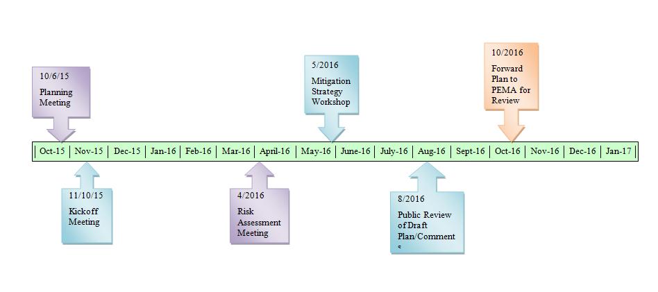
Risk Assessment Planning Team Meeting April 5, 2016
|
|
|
- Hilary Cummings
- 5 years ago
- Views:
Transcription

1 Risk Assessment Planning Team Meeting April 5, 2016

2 Welcome and Introductions Project Overview & Kickoff Meeting Summary Capability Assessment, Evaluation of Identified Hazards & Risks, NFIP Review Risk Assessment Hazard Identification Risk Assessment Summary by Hazard Hazard Ranking and Risk Factor Mitigation Strategy What is a Mitigation Strategy? Goals and Objectives Mitigation Action Techniques Mitigation Action Plan Development Planning Timeline Question and Answer Session
3 Discussed Planning Process and Local Requirements Assessed Capabilities Evaluated Hazards


4 Capability Assessment Results Evaluation of Identified Hazards and Risks Results
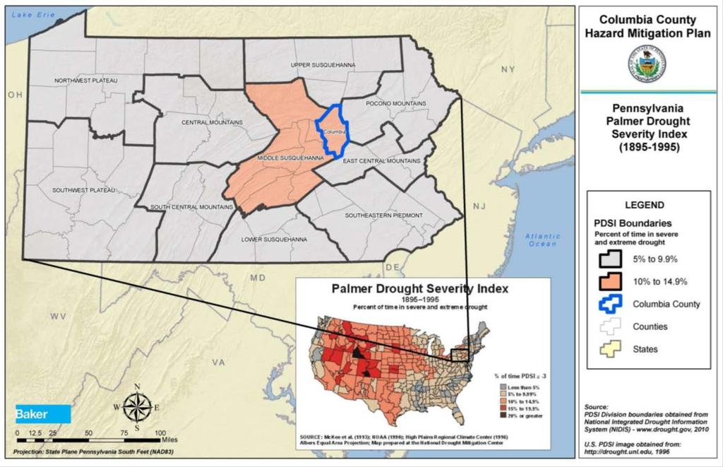
5
6 PA DEP Drought Data 2 Watch in 2015 Decreased Palmer Drought Severity Index ( ) PA in severe or extreme drought 10%-14.9% Future Occurrence Risk Factor Methodology Possible
7 Risk Factor Value = [(Probability x.30) + (Impact x.30) + (Spatial Extent x.20) + (Warning Time x.10) + (Duration x.10)] (2 x.30) + (1 x.30) + (4 x.20) + (1 x.10) + (4 x.10) = = Moderate Hazard

8
9 National Weather Service 4 flash flooding events since last plan Future Occurrence Risk Factor Methodology Highly Likely Critical Facilities, Structure & Population Vulnerability, Worst Case Scenario
10 Risk Factor Value = [(Probability x.30) + (Impact x.30) + (Spatial Extent x.20) + (Warning Time x.10) + (Duration x.10)] (4 x.30) + (3 x.30) + (3 x.20) + (2 x.10) + (3 x.10) = = High Hazard


11
12
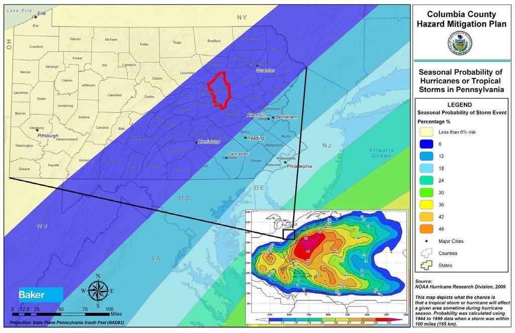
13 Saffir-Simpson Scale NOAA 6% chance tropical storm/hurricane between June & November Future Occurrence Risk Factor Methodology Possible
14 Risk Factor Value = [(Probability x.30) + (Impact x.30) + (Spatial Extent x.20) + (Warning Time x.10) + (Duration x.10)] (2 x.30) + (2 x.30) + (2 x.20) + (1 x.10) + (2 x.10) = = Low Hazard
15
16 Historical events Loss of life & property damage unlikely Future Occurrence Risk Factor Methodology Possible
17 Risk Factor Value = [(Probability x.30) + (Impact x.30) + (Spatial Extent x.20) + (Warning Time x.10) + (Duration x.10)] (2 x.30) + (1 x.30) + (3 x.20) + (2 x.10) + (2 x.10) = = Low Hazard
18 Columbia County Expected to experience pandemic outbreak every 11 to 41 years 41 cases and 1 death from H1N1 in the outbreak Future Occurrence Risk Factor Methodology Possible
19 Table : List of previous significant outbreaks of influenza over the past century (Global Security, 2009; World Health Organization, 2009). DATE PANDEMIC NAME/SUBTYPE WORLDWIDE DEATHS (APPROXIMATE) Spanish Flu / H1N1 50 million Asian Flu / H2N million Hong Kong Flu / H3N2 1 million Swine Flu / 2009 H1N1 17,700 Avian Flu West Nile Virus
20 Risk Factor Value = [(Probability x.30) + (Impact x.30) + (Spatial Extent x.20) + (Warning Time x.10) + (Duration x.10)] (2 x.30) + (1 x.30) + (2 x.20) + (1 x.10) + (4 x.10) = = Low Hazard
21
22
23 Columbia County Worst Case April 1982 F2 30 yards wide & 4 miles long $25,000 damage & one injury April 2002 F1 300 yards wide & 6 miles long $360,000 damage & no injuries
24 Between 1950 & tornados (F3, F4, & F5) per 3,700 sq. miles 30% 39% chance of F3, F4, or F5 tornado per year Future Occurrence Risk Factor Methodology Possible
25 Risk Factor Value = [(Probability x.30) + (Impact x.30) + (Spatial Extent x.20) + (Warning Time x.10) + (Duration x.10)] (4 x.30) + (2 x.30) + (3 x.20) + (2 x.10) + (1 x.10) = = High Hazard
26
27 Wildfire ratings in Columbia County Based on fuel, topography & local weather 14 high 11 medium 7 low Between 2010 & 2014, District 18, Weiser 541 fires 995 Acres burned Future Occurrence Risk Factor Methodology Possible
28 Risk Factor Value = [(Probability x.30) + (Impact x.30) + (Spatial Extent x.20) + (Warning Time x.10) + (Duration x.10)] (2 x.30) + (1 x.30) + (2 x.20) + (3 x.10) + (1 x.10) = = Low Hazard
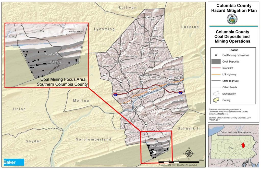
29
30 Table : Probability of Measurable Snowfall in Columbia County by Snow Station Location (NCDC, 2011a). MONTH PROBABILITY (%) BERWICK MILLVILLE 2 SW January % 97.60% February 96.60% 95.00% March 86.70% 84.20% April 16.70% 21.40% May 0.00% 0.00% June 0.00% 0.00% July 0.00% 0.00% August 0.00% 0.00% September 0.00% 0.00% October 3.20% 2.50% November 46.90% 56.10% December 90.60% 87.50% Future Occurrence Risk Factor Methodology Highly Likely
31 Risk Factor Value = [(Probability x.30) + (Impact x.30) + (Spatial Extent x.20) + (Warning Time x.10) + (Duration x.10)] (4 x.30) + (2 x.30) + (4 x.20) + (1 x.10) + (2 x.10) = = High Hazard
32
33 Columbia County 20 facilities using or storing extremely hazardous substances Planning process continually evaluated by LEPC EPA Identified Toxic Release Inventory (TRI) Six Identified Sites as of 2014 Transportation of Hazardous Materials Roadway Railway Atlantic Sunrise Expansion Project Potential for accidents similar to any transportation method
34 Principal Classes of Hazardous Materials Flammable liquids Corrosives Flammable gases Most Common Substances Diesel fuel Propane Fuel oils Most Common EHS Chlorine Sulfuric Acid
35
36 No active underground mines 3 active surface mines 41 employees 323,036 tons of coal produced (2014) Potential problems Mine subsidence Underground fire Stream contamination from mine drainage Modification of vegetation Elevation changes
37
38 Columbia County No active oil or gas wells 3 plugged wells 2 Sugarloaf 1 Jackson No active Marcellus shale wells Potential problems Surface water and soil contamination Fires, blowouts, explosions Surface water depletion from fracking
39 Hazardous material releases occur frequently, but difficult to predict Oil & gas wells o Monitored strictly through DEP reducing potential Coal mining o o Less prominent, decreasing risk Mine subsidence remains a concern Future Occurrence Risk Factor Methodology Likely
 + (Duration x.10)] (3 x.30) + (3 x.30) + (3 x.20) + (4 x.10) + (2 x.10) = 3.0 3.")
40 Risk Factor Value = [(Probability x.30) + (Impact x.30) + (Spatial Extent x.20) + (Warning Time x.10) + (Duration x.10)] (3 x.30) + (3 x.30) + (3 x.20) + (4 x.10) + (2 x.10) = = High Hazard
41
42 Plume Exposure Pathway EPZ Exposure to whole body radiation from radioactive plume 10 miles Eight municipalities Ingestion Exposure Pathway EPZ Exposure from ingestion of water or foods contaminated with radiation 50 miles Entire county
43 Three Mile Island March 1979 General Emergency Worst case scenario for Columbia County General Emergency Historical events for Columbia County Five unusual events Three alerts
44 Risk Factor Value = [(Probability x.30) + (Impact x.30) + (Spatial Extent x.20) + (Warning Time x.10) + (Duration x.10)] (1 x.30) + (2 x.30) + (3 x.20) + (4 x.10) + (4 x.10) = = Moderate Hazard
45 Fuel, water, electric, telecommunications Primary focus electric power failure Impacts Food spoilage Loss of water supply Loss of heating/air conditioning Basement flooding Lack of indoor lighting Lack of telephone & internet service
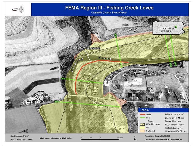
46 Worst case scenario for Columbia County Winter storm causing long term regional outages Injury or death due to inability to heat homes Short term utility interruptions Difficult to predict Frequent by-product of severe weather events Future Occurrence Risk Factor Methodology Possible
47 Risk Factor Value = [(Probability x.30) + (Impact x.30) + (Spatial Extent x.20) + (Warning Time x.10) + (Duration x.10)] (2 x.30) + (1 x.30) + (3 x.20) + (3 x.10) + (2 x.10) = = Moderate Hazard
48
49 Radon gas Cannot be seen or smelled Exposure is 2 nd leading cause of lung cancer Number one cause in non-smokers Responsible for 21,000 lung cancer deaths each year 2,900 in people who never smoked
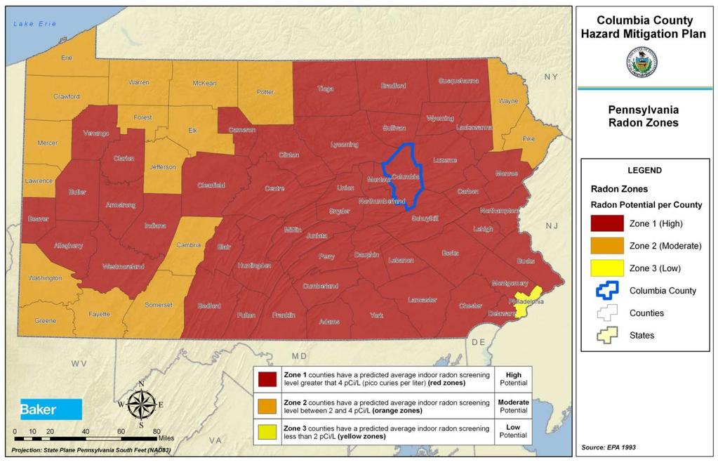
50 Nationwide average Inside homes 1.3 pci/l Outdoors 0.4 pci/l Pennsylvania Mostly zone 1 Predicted indoor average of more than 4.0 pci/l 270,000 homes estimated - levels of 20 pci/l or higher Only 10% of homes in PA have been tested Future Occurrence Risk Factor Methodology Possible
51 Risk Factor Value = [(Probability x.30) + (Impact x.30) + (Spatial Extent x.20) + (Warning Time x.10) + (Duration x.10)] (2 x.30) + (1 x.30) + (1 x.20) + (4 x.10) + (4 x.10) = = Low Hazard
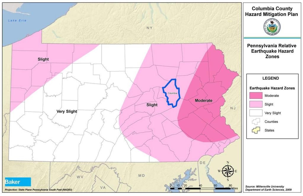
52
53
54 Columbia County Two levees One failure in September 2011 Fishing Creek Levee in Orangeville One home and One cabin Vulnerability Homes and businesses behind levee in Orange Twp. One active & one empty factory in Bloomsburg
55 Risk Factor Value = [(Probability x.30) + (Impact x.30) + (Spatial Extent x.20) + (Warning Time x.10) + (Duration x.10)] (1 x.30) + (2 x.30) + (1 x.20) + (4 x.10) + (3 x.10) = = Low Hazard
56 Table : Dams per municipality in Columbia County (DEP, 2016). MUNICIPALITY # DAMS MUNICIPALITY # DAMS Beaver Township 3 Locust Township 0 Benton Borough 1 Madison Township 0 Benton Township 2 Main Township 0 Berwick Borough 0 Mifflin Township 1 Bloomsburg, Town of 0 Millville Borough 0 Briar Creek Borough 0 Montour Township 1 Briar Creek Township 3 Mt Pleasant Township 0 Catawissa Borough 0 North Centre Township 0 Catawissa Township 1 Orange Township 0 Centralia Borough 0 Orangeville Borough 1 Cleveland Township 0 Pine Township 1 Conyngham Township 2 Roaring Creek Township 2 Fishing Creek Township 1 Scott Township 0 Franklin Township 0 South Centre Township 0 Greenwood Township 0 Stillwater Borough 0 Hemlock Township 0 Sugarloaf Township 1 Jackson Township 0 TOTAL 20
57 20 high hazard, significant, low-hazard dams in Columbia County 2 High hazard dams in county Both in Briar Creek Township Major threat to residents 7 High hazard dams outside of county which pose a threat to the county Future Occurrence Risk Factor Methodology Unlikely
58 Risk Factor Value = [(Probability x.30) + (Impact x.30) + (Spatial Extent x.20) + (Warning Time x.10) + (Duration x.10)] (1 x.30) + (3 x.30) + (2 x.20) + (4 x.10) + (2 x.10) = = Moderate Hazard
59
60 DCNR no earthquakes with epicenter located in Columbia County Earthquakes near Columbia County Magnitude less than 3.5 Earthquakes in Pennsylvania Magnitude less than 6.0 Future Occurrence Risk Factor Methodology Unlikely
61 Risk Factor Value = [(Probability x.30) + (Impact x.30) + (Spatial Extent x.20) + (Warning Time x.10) + (Duration x.10)] (1 x.30) + (1 x.30) + (1 x.20) + (4 x.10) + (1 x.10) = = Low Hazard
62 HAZARD RISK HAZARD NATURAL (N) or MAN- MADE (M) PROBABILITY RISK ASSESSMENT CATEGORY IMPACT SPATIAL EXTENT WARNING TIME DURATION RISK FACTOR Flood, Flash Flood, Ice Jam (N) HIGH MODERATE LOW Environmental Hazards (M) Winter Storm (N) Tornado, Windstorm (N) Nuclear Incident (M) Dam Failure (M) Drought (N) Utility Interruption (M) Hurricane, Tropical Storm, Nor'easter (N) Landslide (N) Radon Exposure (N) Levee Failure (M) Pandemic (N) Wildfire (N) Earthquake (N)
63 Flood, Flash Flood, Ice Jam Environmental Hazards Winter Storm Tornado, Windstorm Nuclear Incident Dam Failure Drought Utility Interruption Hurricane, Tropical Strom, Nor Easter Landslide Radon Exposure Levee Failure Pandemic Wildfire Earthquake Beaver Township = = = = > > = = = = = = = > = Benton Borough > = = = = = = = = < = = = > = Benton Township = = = = = = = = = < = = = < = Berwick Borough = = = = > > = = = = = = > = = Bloomsburg, Town of > = = = = < = > = = = > > < = Bloomsburg University < = = = = < = = = = = = > < = Briar Creek Borough = = = = > > = = = = = = = < = Briar Creek Township = = = = > > = = = = = = = > = Catawissa Borough > = = = = = = = = = = = = < = Catawissa Township = = = = = < = = = = = = = > = Centralia Borough < = = = = < = = < = = = = < =

64 Flood, Flash Flood, Ice Jam Environmental Hazards Winter Storm Tornado, Windstorm Nuclear Incident Dam Failure Drought Utility Interruption Hurricane, Tropical Strom, Nor Easter Cleveland Township = = = = = = = = = = = = = < = Conyngham Township = = = = = = = = = = = = = = = Fishing Creek Township = = = = > = Landslide Radon Exposure = = = < = = = < = Levee Failure Pandemic Wildfire Earthquake Franklin Township = = = = = < = = = = = = = < = Greenwood Township = = = = = = = = = < = = = < = Hemlock Township > = = = = < = > = = = = = < = Jackson Township = = = = = < = = = = = = = = = Locust Township = = = = < < = = = = = = = = = Madison Township = = = = = < = = = < = = = < = Main Township = = = = = < = = = = = = = = = Mifflin Township = = = = > = = = = = = = = = =
65 Flood, Flash Flood, Ice Jam Environmental Hazards Winter Storm Tornado, Windstorm Nuclear Incident Dam Failure Drought Utility Interruption Hurricane, Tropical Strom, Nor Easter Millville Borough = = = = = < = = = = = = = < = Montour Township > = = = = = = > = > = = = < = Mt. Pleasant Township = = = = = < = = = = = = = < = North Centre Township = = = = > < = = = = = = = = = Orange Township = = = = = < = = = = = > = = = Orangeville Borough = = = = = < = = = = = = = < = Pine Township = = = = = = = = = = = = = < = Roaring Creek Township = = = = = > = = = = = = = = = Scott Township = = = = = < = > = = = = = < = South Centre Township = = = = > < = = = = = = = = = Stillwater Borough = = = = = < = = = = = = = < = Sugarloaf Township = = = = = = = = = > = = = = = Landslide Radon Exposure Levee Failure Pandemic Wildfire Earthquake
66 Handout: Risk Factor and Jurisdictional Risk Matrix. Part I-Provide comments on the countywide hazard-risk rankings and Risk Factor. Part II-Provide comments on your jurisdictional risk and how it compares to the County.


67 The approach you take to reduce or avoid long-term vulnerabilities to the identified hazards Goals Objectives Actions & Projects
68 Goals: General guidelines that describe what your community would like to achieve. Objectives: Define strategies that must be implemented to achieve the identified goal. Objectives are more specific and measureable.

69 Example: Goal: Increase public awareness and support for hazard mitigation. Objective: Publicize the hazard mitigation plan and encourage the implementation of mitigation actions.
70 Handout: Proposed Goals with corresponding Objectives. Provide comments on any Goals or Objectives that you feel need to be revised, eliminated or replaced. Suggest other Goals and Objectives based on perceived need.

71 Six Categories of Mitigation Techniques: Prevention Property Protection Public Education and Awareness Natural Resource Protection Structural Project Implementation Emergency Services

72 Identifies a comprehensive range of specific mitigation actions and projects being considered to reduce the effects of each hazard. Example: Goal: Increased public awareness and support for hazard mitigation Objective: Publicize the hazard mitigation plan and encourage the implementation of mitigation actions. Action: Set up a booth at the Bloomsburg Fair and distribute hazard mitigation information
73 Handout: Mitigation Action Form A Mitigation Action should include the following information Action title Jurisdiction(s) involved Mitigation technique category (see handout) Hazard(s) addressed Estimated cost Potential funding source(s) Lead agency or department Implementation schedule
74
VULNERABILITY ASSESSMENT
 SOUTHSIDE HAMPTON ROADS HAZARD MITIGATION PLAN VULNERABILITY ASSESSMENT 2011 UPDATE Each of the hazards in this section was reviewed and updated to reflect the revised information obtained for the updated
APPENDIX D PLANNING PROCESS DOCUMENTATION
 APPENDIX D PLANNING PROCESS DOCUMENTATION This appendix includes the following: 1. Meeting Agendas 2. Meeting Minutes 3. Meeting Sign-In Sheets 4. Public Survey Summary Results 1) Introductions AGENDA
Hazard Vulnerability Assessment for Long Term Care Facilities
 Hazard Vulnerability Assessment for Long Term Care Facilities Dave Seebart WHEPP Reg. 3, Project Manager April 23, 25, & 26, 2013 1 Hazard Vulnerability Assessment (HVA) for Long Term Care Facilities (LTCF)
Natural Hazards Risks in Kentucky. KAMM Regional Training
 Natural Hazards Risks in Kentucky KAMM Regional Training Floodplain 101 Kentucky has approximately 92,000 linear miles of streams and rivers Approximately 31,000 linear miles have mapped flood hazards
9.2 ALBURTIS BOROUGH. This section presents the jurisdictional annex for Alburtis Borough. A. HAZARD MITIGATION PLAN POINT OF CONTACT
 9.2 ALBURTIS BOROUGH This section presents the jurisdictional annex for Alburtis Borough. A. HAZARD MITIGATION PLAN POINT OF CONTACT Name Title/ Department Address Telephone Fax Email Primary Point of
Town of Montrose Annex
 Town of Montrose Annex Community Profile The Town of Montrose is located in the Southwest quadrant of the County, east of the Town of Primrose, south of the Town of Verona, and west of the Town of Oregon.
9.10 HEIDELBERG TOWNSHIP
 9.10 HEIDELBERG TOWNSHIP This section presents the jurisdictional annex for Heidelberg Township. A. HAZARD MITIGATION PLAN POINT OF CONTACT Name Title/ Department Address Telephone Fax Email Primary Point
SOUTH CENTRAL REGION MULTI-JURISDICTION HAZARD MITIGATION PLAN. Advisory Committee Meeting September 12, 2012
 SOUTH CENTRAL REGION MULTI-JURISDICTION HAZARD MITIGATION PLAN Advisory Committee Meeting September 12, 2012 AGENDA FOR TODAY Purpose of Meeting Engage All Advisory Committee Members Distribute Project
Village of Blue Mounds Annex
 Village of Blue Mounds Annex Community Profile The Village of Blue Mounds is located in the southwest quadrant of the County, north of the town of Perry, west of the town of Springdale, and south of the
Planning Process Documentation
 Appendix D Planning Process Documentation This appendix includes: 1. Meeting Agendas 2. Meeting Minutes 3. Meeting Sign-In Sheets AGENDA Wake County Multi-Jurisdictional Hazard Mitigation Plan West Wake
in coordination with Peoria County, Planning and Zoning Department
 Prepared by Amec Foster Wheeler Environment & Infrastructure Hazard Mitigation and Emergency Management Program in coordination with Peoria County, Planning and Zoning Department The purpose of hazard
9.8 FOUNTAIN HILL BOROUGH
 9.8 FOUNTAIN HILL BOROUGH This section presents the jurisdictional annex for Fountain Hill Borough. A. HAZARD MITIGATION PLAN POINT OF CONTACT Name Title/ Department Address Telephone Fax Email Primary
Prerequisites for EOP Creation: Hazard Identification and Assessment
 Prerequisites for EOP Creation: Hazard Identification and Assessment Presentation to: Advanced Healthcare Emergency Management Course Objectives Upon lesson completion, you should be able to: Understand
COMMUNITY SUMMARY LINN COUNTY MULTI-JURISDICTIONAL HAZARD MITIGATION PLAN CITY OF CENTRAL CITY
 COMMUNITY SUMMARY LINN COUNTY MULTI-JURISDICTIONAL HAZARD MITIGATION PLAN CITY OF CENTRAL CITY This document provides a summary of the hazard mitigation planning information for the City of Central City
Sussex County All Hazard Mitigation Plan. Plan Executive Summary
 Sussex County All Hazard Mitigation Plan Plan Executive Summary March 2010 SUSSEX COUNTY ALL HAZARD MITIGATION PLAN SUMMARY March 2010 For questions and to make comments on this document, contact: Joseph
2015 Mobile County, Alabama Multi-Hazard Mitigation Plan Appendices
 2015 Mobile County, Alabama Multi-Hazard Mitigation Plan A - Federal Requirements for local Mitigation Plans B - Community Mitigation Capabilities C - 2009 Plan Implementation Status D - Hazard Ratings
Appendix F: Ozark special Road District Addendum
 Appendix F: Ozark special Road District Addendum F-1: Introduction and Planning Process F-1.1 Purpose The Christian County 2016 Multi-Jurisdictional Natural Hazards Mitigation Plan is an updated version
Southwest Florida Healthcare Coalition
 Southwest Florida Healthcare Coalition Hazards Vulnerability Assessment 2018 1 Table of Contents Summary 3 EmPower Maps and Data 5 Social Vulnerability Index Maps 19 Suncoast Disaster Healthcare Coalition
COMMUNITY SUMMARY LINN COUNTY MULTI-JURISDICTIONAL HAZARD MITIGATION PLAN CITY OF LISBON
 COMMUNITY SUMMARY LINN COUNTY MULTI-JURISDICTIONAL HAZARD MITIGATION PLAN CITY OF LISBON This document provides a summary of the hazard mitigation planning information for the City of Lisbon that will
VULNERABILITY ASSESSMENT
 SOUTHSIDE HAMPTON ROADS HAZARD MITIGATION PLAN VULNERABILITY ASSESSMENT INTRODUCTION The Vulnerability Assessment section builds upon the information provided in the Hazard Identification and Analysis
Ch. 112 NATURAL DISASTER REIMBURSEMENT CHAPTER 112. NATURAL DISASTER REIMBURSEMENT PROGRAM FOR POLITICAL SUBDIVISIONS
 Ch. 112 NATURAL DISASTER REIMBURSEMENT 4 112.1 CHAPTER 112. NATURAL DISASTER REIMBURSEMENT PROGRAM FOR POLITICAL SUBDIVISIONS Sec. 112.1. Scope. 112.2. Policy. 112.3. Definitions. 112.4. Responsibilities.
APPENDIX B: CITIZEN SURVEY
 APPENDIX B: CITIZEN SURVEY B1 CONVERSE COUNTY HAZARD MITIGATION PLAN SURVEY March 30, 2011 Prepared for: Converse County Emergency Management Agency Prepared by: Ken Markert, AICP MMI Planning Cody, WY.
Hazard Mitigation Planning
 Hazard Mitigation Planning Mitigation In order to develop an effective mitigation plan for your facility, residents and staff, one must understand several factors. The first factor is geography. Is your
Hazard Mitigation Plan Planning Perspective
 7. A. Hazard Mitigation Plan Planning Perspective B. Public Meeting Notice A. Hazard Mitigation Plan Planning Perspective York County Hazard Mitigation Plan Hazard Mitigation Plan Planning Perspective
6. MITIGATION STRATEGY. 62 municipalities have devised. 1,161 actions designed to prepare the Lehigh Valley for disaster.
 6. MITIGATION STRATEGY 6.1 UPDATE PROCESS SUMMARY The 2018 Plan focuses on improving the county and local mitigation strategies from the 201 Plan. Throughout the planning process, both counties and all
PUBLIC SURVEY FOR HAZARD MITIGATION PLANNING
 PUBLIC SURVEY FOR HAZARD MITIGATION PLANNING We need your help! The Counties of Cherokee, Graham, Haywood, Jackson, Swain, and the Eastern Band of Cherokee Indians are currently engaged in a planning process
SECTION 6 - RANGE OF ALTERNATIVE MITIGATION ACTIONS CONSIDERED
 SECTION 6 - RANGE OF ALTERNATIVE MITIGATION ACTIONS CONSIDERED For this hazard mitigation plan to be approved by FEMA, each participating jurisdiction was required to identify and analyze a comprehensive
9.15 MACUNGIE BOROUGH
 9.15 MACUNGIE BOROUGH This section presents the jurisdictional annex for Macungie Borough. A. HAZARD MITIGATION PLAN POINT OF CONTACT Name Title/ Department Address Telephone Fax Email Primary Point of
Multi-Jurisdictional Hazard Mitigation Plan. Data Collection Questionnaire. For School Districts and Educational Institutions
 Multi-Jurisdictional Hazard Mitigation Plan Data Collection Questionnaire For School Districts and Educational Institutions County: School District / Educational Institution Name: Return by: Please complete
Somerset County Mitigation Plan Update
 Somerset County Multi-Jurisdictional Hazard Mitigation Plan Update Kickoff Meeting Agenda Kickoff Meeting September 28, 2017 6:00 pm SCES, 402 Roycefield Road, Hillsborough, NJ Welcome and Opening Remarks.....
Assessing Risk: Shifting Focus from Hazards to Capabilities. Jane Coolidge Kara Walker CMRHCC April 2017
 Assessing Risk: Shifting Focus from Hazards to Capabilities Jane Coolidge Kara Walker CMRHCC April 2017 Hazards Vulnerability Analysis (HVA): Overview To identify jurisdictional hazards To assess hazard
EXECUTIVE SUMMARY. Onondaga County Multi-Jurisdictional Planning Process
 EXECUTIVE SUMMARY The Onondaga County Multi-Jurisdictional All-Hazards Mitigation Plan was prepared in response to the Disaster Mitigation Act of 2000 (DMA 2000). DMA 2000 requires states and local governments
Emergency Preparedness. Emergency Preparedness & the Senior Housing Provider. The Speakers LEGAL REQUIREMENTS
 Emergency Preparedness & the Senior Housing Provider LEADINGAGE MINNESOTA 2015 SENIOR LIVING NOW! CONFEREN CE SESSIONS #107 AND #207 The Speakers Andrew Tepfer All-Hazard Planner Homeland Security & Emergency
9.24 WEISENBERG TOWNSHIP
 9.24 WEISENBERG TOWNSHIP This section presents the jurisdictional annex for Weisenberg Township. A. HAZARD MITIGATION PLAN POINT OF CONTACT Name Title/ Department Address Telephone Fax Email Primary Point
Northern Kentucky University 2018 Hazard Mitigation Plan. Public Kick-Off Meeting March 20, 2018
 Northern Kentucky University 2018 Hazard Mitigation Plan Public Kick-Off Meeting March 20, 2018 Agenda Welcome Hazard Mitigation Planning 101 Hazard Identification Exercises Next Steps Jeff Baker, NKU
9.11 BETHLEHEM TOWNSHIP
 9.11 BETHLEHEM TOWNSHIP This section presents the jurisdictional annex for Bethlehem. A. HAZARD MITIGATION PLAN POINT OF CONTACT Name Title/ Department Address Telephone Fax Email Primary Point of Contact
9.46 NAZARETH BOROUGH
 9.46 NAZARETH BOROUGH This section presents the jurisdictional annex for Nazareth Borough. A. HAZARD MITIGATION PLAN POINT OF CONTACT Name Title/ Department Address Telephone Fax Email Primary Point of
G318 Local Mitigation Planning Workshop. Module 2: Risk Assessment. Visual 2.0
 G318 Local Mitigation Planning Workshop Module 2: Risk Assessment Visual 2.0 Unit 1 Risk Assessment Visual 2.1 Risk Assessment Process that collects information and assigns values to risks to: Identify
EvCC Emergency Management Plan ANNEX #11 Hazard Assessment
 1. INTRODUCTION The risk and vulnerability assessment process detailed here identifies the hazards the Evict Campus faces and assesses the level of vulnerability to these potential events. Conducting a
Section II: Vulnerability Assessment and Mitigation
 Section II: Vulnerability Assessment and Mitigation 1. Hazard Vulnerability Analysis (facility name) should conduct a thorough Hazard Vulnerability Analysis to help determine what events or incidents may
Name Title/ Department Address Telephone Fax
 9.14 LYNN TOWNSHIP This section presents the jurisdictional annex for Lynn Township. A. HAZARD MITIGATION PLAN POINT OF CONTACT Name Title Address Telephone Fax Email Primary Point of Contact Janet Henritzy
BREWER & COMPANY, LLC CENTRAL COLUMBIA SCHOOL DISTRICT REAL ESTATE AND PER CAPITA TAX COLLECTIONS SETTLEMENTS FOR THE YEAR ENDED DECEMBER 31, 2011
 BLOOMSBURG, PENNSYLVANIA 17815 CERTIFIED PUBLIC A CCO UNTANTS BREWER & COMPANY, LLC & FOR THE YEAR ENDED COLLECTIONS SETTLEMENTS DECEMBER 31, 2011 INDEPENDENT AUDITORS REPORT REAL ESTATE AND PER CAPITA
HAZARD MITIGATION PLANNING
 HAZARD MITIGATION PLANNING Oswego County HMP Update Working Group Kickoff Meeting September 27, 2017 Agenda Welcoming Remarks Oswego County Emergency Management DHSES FEMA Introduce Executive Committee
GUIDE BUSINESS & INDUSTRY A STEP-BY-STEP APPROACH TO EMERGENCY PLANNING, RESPONSE AND RECOVERY FOR COMPANIES OF ALL SIZES
 GUIDE EMERGENCY MANAGEMENT GUIDE FOR BUSINESS & INDUSTRY A STEP-BY-STEP APPROACH TO EMERGENCY PLANNING, RESPONSE AND RECOVERY FOR COMPANIES OF ALL SIZES Sponsored by a Public-Partnership with the Federal
Introduction to Disaster Management
 Introduction to Disaster Management Definitions Adopted By Few Important Agencies WHO; A disaster is an occurrence disrupting the normal conditions of existence and causing a level of suffering that exceeds
REPUBLIC OF BULGARIA
 REPUBLIC OF BULGARIA DISASTER RISK REDUCTION STRATEGY INTRUDUCTION Republic of Bulgaria often has been affected by natural or man-made disasters, whose social and economic consequences cause significant
Meeting Date Time Location Attendees Purpose
 MEETING NOTES Meeting Bedford County Hazard Mitigation Plan Planning Team Kickoff Meeting Date October 19, 2016 Time 7:00-8:40 p.m. Location Bedford Elementary School, 3639 Business 220, Bedford, PA Donald
DeSoto Parish Hazard Mitigation Plan Update Kick-off Meeting. February 16, 2016 Grand Cane, LA
 DeSoto Parish Hazard Mitigation Plan Update Kick-off Meeting February 16, 2016 Grand Cane, LA Introductions Officials Mitigation Steering Committee members SDMI team members GOHSEP hazard mitigation team
A Practical Framework for Assessing Emerging Risks
 A Practical Framework for Assessing Emerging Risks John Bowman, MBCI Enterprise Business Continuity Management Share one approach to assess the current level of business continuity risk in your organization.
Dade County Natural Hazard Mitigation Plan
 Introduction to Mitigation Definition of Mitigation Mitigation is defined by FEMA as "...sustained action that reduces or eliminates longterm risk to people and property from natural hazards and their
Section 9. Emergency Management Accreditation Program
 Section 9. Emergency Management Accreditation Program 2014 Plan Update Changes The Emergency Management Accreditation Program is a new section. In the 2011 Plan, EMAP information was found following each
Section 1: Introduction
 [THREE RIVERS ELECTRIC COOPERATIVE] May 18, 2012 Section 1: Introduction Three Rivers Electric Cooperative (Three Rivers) was established in 1939 to provide electric service to the rural areas of central
Climate risk management plan. Towards a resilient business
 Type your organisation name here Climate risk management plan Towards a resilient business 1 2 3 4 5 1 2 3 4 5 1 2 3 4 5 Click the numbers to select your cover images 1 2 3 4 5 Document control sheet Document
SUMMARY NOTES OF THE FEBRUARY 13, 2018 MEETING OF THE OZAUKEE COUNTY HAZARD MITIGATION PLAN LOCAL PLANNING TEAM
 SUMMARY NOTES OF THE FEBRUARY 13, 2018 MEETING OF THE OZAUKEE COUNTY HAZARD MITIGATION PLAN LOCAL PLANNING TEAM INTRODUCTION The February 13, 2018 meeting of the Ozaukee County Hazard Mitigation Plan Local
ANNEX B: TOWN OF BLUE RIVER
 ANNEX B: TOWN OF BLUE RIVER B.1 Community Profile Figure B.1 shows a map of the Town of Blue River and its location within Summit County. Figure B.1. Map of Blue River Summit County (Blue River) Annex
FACILITY NAME. CONSIDERATIONS FOR COMPLETING THE ANALYSIS FORMS The following instructions were modified from the Kaiser Permanente HVA tool
 FACILITY NAME CONSIDERATIONS FOR COMPLETING THE ANALYSIS FORMS The following instructions were modified from the Kaiser Permanente HVA tool 1) Change "Facility Name" at the top of this Instruction Tab
Multi-Jurisdictional Hazard Mitigation Plan. Data Collection Questionnaire. For Local Governments
 Multi-Jurisdictional Hazard Mitigation Plan Data Collection Questionnaire County: For Local Governments Jurisdiction: Return to: Marcus Norden, Regional Planner BRP&EC Please complete this data collection
Commonwealth of Pennsylvania 2018 State Hazard Mitigation Plan Review Draft: June 29, 2018
 Commonwealth of Pennsylvania 2018 State Hazard Mitigation Plan Review Draft: June 29, 2018 Prepared for: Pennsylvania Emergency Management Agency 2605 Interstate Drive Harrisburg, PA 17110 Prepared by:
Table presents the numerical rating, weighted factor and description for each impact category
 5.3 HAZARD RANKING After the hazards of concern were identified for Dutchess County, the hazards were ranked to describe their probability of occurrence and their impact on population, property (general
Emergency Resilience Risk Assessment
 Emergency Resilience Assessment ANNEX 3 vember 2011 The Operating Framework for the NHS in England 2011/12 states: Emergency Preparedness and Resilience across the NHS continues to be a high priority.
Section 1: Introduction
 Section 1: Introduction [SEMO ELECTRIC COOPERATIVE] May 18, 2012 SEMO Electric Cooperative (SEMOEC) was established in 1938 to provide electric service to the rural areas of southeast Missouri. SEMOEC
APPENDIX H TOWN OF FARMVILLE. Hazard Rankings. Status of Mitigation Actions. Building Permit Data. Future Land Use Map. Critical Facilities Map
 APPENDIX H TOWN OF FARMVILLE Hazard Rankings Status of Mitigation Actions Building Permit Data Future Land Use Map Critical Facilities Map Zone Maps Hazard Rankings (From Qualitative Assessment and Local
Garfield County NHMP:
 Garfield County NHMP: Introduction and Summary Hazard Identification and Risk Assessment DRAFT AUG2010 Risk assessments provide information about the geographic areas where the hazards may occur, the value
Sioux County, Iowa. Mitigation Plan
 Sioux County, Iowa Part B of the Comprehensive County-Wide Emergency Operations Plan Prepared by: Mark Dunlop, Coordinator Sioux County Emergency Management Agency Orange City, Iowa 51041 February, 2003
PART 3 LOCAL MITIGATION PLANS
 PART 3 LOCAL MITIGATION PLANS Local Mitigation Plan requirements in 44 CFR, Part 201.6 of the Interim Final Rule (the Rule) apply to both local jurisdictions and Tribal governments that elect to participate
Section 1: Introduction
 [PEMISCOT-DUNKLIN ELECTRIC COOPERATIVE] May 18, 2012 Section 1: Introduction Pemiscot-Dunklin Electric Cooperative (PDEC) was established in 1937 to provide electric service to the rural areas of southeast
APPENDIX A: PLANNING PROCESS DOCUMENTATION
 APPENDIX A: PLANNING PROCESS DOCUMENTATION Region 2 1 Regional Hazard Mitigation Plan 2018 Appendix C Appendix C Today s Agenda What is Hazard Mitigation? Process Review Goals Review Review of Current
SMALL BUSINESS. Guide to Business. Continuity Planning. Ensure your business continues to operate in the event of a disruption.
 SMALL BUSINESS Guide to Business Continuity Planning Ensure your business continues to operate in the event of a disruption. You don t expect your home to burn down. However, you buy insurance to be prepared
5.3 HAZARD RANKING HAZARD RANKING METHODOLOGY
 5.3 HAZARD RANKING After the hazards of concern were identified for Burlington County, the hazards were ranked to describe their probability of occurrence and their impact on population, property (general
Appendix C Community Hazards Public Survey
 Appendix C Community Hazards Public Survey The planning process included participation of representatives from local government agencies and departments, stakeholder groups, and the general public. Public
Natural Hazards Mitigation Plan Kankakee County, Illinois Executive Summary
 1. Introduction Natural Hazards Mitigation Plan Kankakee County, Illinois Executive Summary Kankakee County is subject to natural hazards that threaten life, safety, health, and welfare and cause extensive
ANNEX F REQUIRED PLANNING DOCUMENTATION CHATHAM COUNTY MULTI-JURISDICTION PRE-DISASTER HAZARD MITIGATION PLAN DECEMBER 2015
 ANNEX F REQUIRED PLANNING DOCUMENTATION CHATHAM COUNTY MULTI-JURISDICTION PRE-DISASTER HAZARD MITIGATION PLAN DECEMBER 2015 Chatham County Pre-Disaster Hazard Mitigation Plan Annexes F-1 THIS PAGE INTENTIONALLY
Osceola County Hazard Mitigation Plan. Part 3 - Mitigation Strategy
 Osceola County Hazard Mitigation Plan Part 3 - Mitigation Strategy Osceola County Hazard Mitigation Plan - Part 3 Mitigation Strategy 3-1 Contents Tables and Figures... 3 Overview... 4 Strategy... 4 Goals...
HAZARD DESCRIPTION... 1 LOCATION... 2 EXTENT... 4 HISTORICAL OCCURRENCES... 6 PROBABILITY OF FUTURE EVENTS... 6 VULNERABILITY AND IMPACT...
 DAM FAILURE HAZARD DESCRIPTION... 1 LOCATION... 2 EXTENT... 4 HISTORICAL OCCURRENCES... 6 PROBABILITY OF FUTURE EVENTS... 6 VULNERABILITY AND IMPACT... 6 Hazard Description Dams are water storage, control
Town of Pleasant Springs Annex
 Town of Pleasant Springs Annex Community Profile The Town of Pleasant Springs is located in the southeast quadrant of Dane County, west of the Town of Christiana, north of the town of Dunkirk, and east
Name Title/ Department Address Telephone Fax
 9.32 CHAPMAN BOROUGH This section presents the jurisdictional annex for Chapman Borough. A. HAZARD MITIGATION PLAN POINT OF CONTACT Name Title/ Department Address Telephone Fax Email Primary Point of Contact
9.36 HANOVER TOWNSHIP
 9.36 HANOVER TOWNSHIP This section presents the jurisdictional annex for Hanover Township. A. HAZARD MITIGATION PLAN POINT OF CONTACT Name Title/ Department Address Telephone Fax Email Primary Point of
Regional Healthcare Hazard Vulnerability Assessment
 Regional Healthcare Hazard Vulnerability Assessment Prepared by: The Northwest Healthcare Response Network June 5, 2017 2017 Northwest Healthcare Response Network. Regional Healthcare Hazard Vulnerability
LOCAL HAZARD MITIGATION PLAN REVIEW WORKSHEET FEMA REGION 2 Jurisdiction: Jurisdiction: Title of Plan: Date of Plan: Address:
 REVIEW AD APPROVAL TATU Title of Plan: Date of Plan: Local Plan submitted by: Address: Title: Agency: Phone umber: E-Mail: tate Reviewer: Title: Date: FEMA Reviewer: Title: Date: FEMA QA/QC: Title: Date:
Capitol Region Natural Hazards Mitigation Plan Update EXECUTIVE SUMMARY
 2014-2019 Capitol Region Natural Hazards Mitigation Plan Update EXECUTIVE SUMMARY FEMA Approved Pending Adoption August 29, 2014 FEMA Approved December 5, 2014 Capitol Region Natural Hazards Mitigation
The Global Risk Landscape. RMS models quantify the impacts of natural and human-made catastrophes for the global insurance and reinsurance industry.
 RMS MODELS The Global Risk Landscape RMS models quantify the impacts of natural and human-made catastrophes for the global insurance and reinsurance industry. MANAGE YOUR WORLD OF RISK RMS catastrophe
Truckloads (at 25 tons/truck) of building debris 90
 of building debris 90") Marlborough Marlborough is a rural community in Hartford County covering a land area of 23.3 square miles and with an estimated population of 6,410. Elevation ranges from about 160 to 800 feet. The Town
Marlborough Marlborough is a rural community in Hartford County covering a land area of 23.3 square miles and with an estimated population of 6,410. Elevation ranges from about 160 to 800 feet. The Town
Name Title/ Department Address Telephone Fax
 9.36 FORKS TOWNSHIP This section presents the jurisdictional annex for Forks Township. A. HAZARD MITIGATION PLAN POINT OF CONTACT Primary Point of Contact Name Title/ Department Address Telephone Fax Email
49.23 North Plainfield Board of Education
 49.23 North Plainfield Board of Education This section presents the jurisdictional annex for the North Plainfield Board of Education (NPBOE). 9.23.1 HAZARD MITIGATION PLAN POINTS OF CONTACT Primary Point
9.48 NORTHAMPTON BOROUGH
 9.48 NORTHAMPTON BOROUGH This section presents the jurisdictional annex for Northampton Borough. A. HAZARD MITIGATION PLAN POINT OF CONTACT Name Title/ Department Address Telephone Fax Email Primary Point
SECTION 6 VULNERABILITY ASSESSMENT
 SECTION 6 VULNERABILITY ASSESSMENT This section identifies and quantifies the vulnerability of the MEMA District 6 Region to the significant hazards identified in the previous sections (Hazard Identification
Mitigation Action Plan Alamance County
 Mitigation Action Plan Alamance County The Mitigation Action Plan for Alamance County is divided into two subsections: 7.1 Status of Previously Adopted Mitigation Actions 7.2 New 2015 Mitigation Actions
Section 1: Introduction
 [SE-MA-NO ELECTRIC COOPERATIVE] May 18, 2012 Section 1: Introduction Se-Ma-No Electric Cooperative (Se-Ma-No) was organized in 1945 as a member-owned, non-profit cooperative to supply electricity to rural
TABLE OF CONTENTS. Foreword... i. Executive Summary...1. Prerequisites... P.1. Participating Jurisdictions... P.1. Participation Requirements... P.
 TABLE OF CONTENTS Foreword... i Executive Summary...1 Prerequisites... P.1 Participating Jurisdictions... P.1 Participation Requirements... P.2 Record of Participation... P.3 Sample Adoption Resolution...
FREQUENTLY ASKED QUESTION ABOUT FLOODPLAINS Michigan Department of Environmental Quality
 FREQUENTLY ASKED QUESTION ABOUT FLOODPLAINS Michigan Department of Environmental Quality WHAT IS A FLOOD? The National Flood Insurance Program defines a flood as a general and temporary condition of partial
Tangipahoa Parish Hazard Mitigation Plan Update Mitigation Steering Committee Kick-off Meeting. September 9, 2014 Hammond, LA
 Tangipahoa Parish Hazard Mitigation Plan Update Mitigation Steering Committee Kick-off Meeting September 9, 2014 Hammond, LA Introductions Officials Mitigation Steering Committee members SDMI team members
The Mississippi State Department of Health EOPs and HVAs Presented By: Lillie Bailey
 The Mississippi State Department of Health EOPs and HVAs Presented By: Lillie Bailey Introductions Emergency Operations Plan (EOP) Hazard Vulnerability Assessment (HVA) Exercising and Implementation Do
OF CLIMATE CHANGE. Kim Knowlton, DrPH. Assistant Clinical Professor, Mailman School of Public Health, Columbia University
 Images: NOAA VALUING THE HEALTH COSTS OF OF CLIMATE CHANGE Kim Knowlton, DrPH Senior Si Scientist, i Natural Resources Defense Council il(nrdc); Assistant Clinical Professor, Mailman School of Public Health,
Section 1: Introduction
 Section 1: Introduction [WEBSTER ELECTRIC COOPERATIVE] May 18, 2012 Webster Electric Cooperative (WEC) was established in 1946 to provide electric service to the rural areas of southwest Missouri. A Touchstone
APPENDIX E: PLANNING PROCESS DOCUMENTATION
 APPENDIX E: PLANNING PROCESS DOCUMENTATION Appendix E 1 Public Hearing Notice A public hearing will be held for the Greene County Pre-Disaster Mitigation Plan Update on Wednesday, June 27, 2012, at 5:00pm
Appendix E: Mitigation Action Worksheet Template
 This appendix provides the Action Worksheet template, including instructions for its completion, used by the participating jurisdictions to document applicable projects identified in their mitigation strategy,
Otsego County Hazard Mitigation Plan (HMP) Risk Assessment Review Meeting Date November 14, 2018 Time 6:00 8:00 p.m.
 Risk Assessment Review Meeting Date November 14, 2018 Time 6:00 8:00 p.m.") MEETING NOTES Meeting Otsego County Hazard Mitigation Plan (HMP) Risk Assessment Review Meeting Date November 14, 2018 Time 6:00 8:00 p.m. Location Attendees Otsego County Board of Representatives Meeting
MEETING NOTES Meeting Otsego County Hazard Mitigation Plan (HMP) Risk Assessment Review Meeting Date November 14, 2018 Time 6:00 8:00 p.m. Location Attendees Otsego County Board of Representatives Meeting
Table Numerical Values and Definitions for Impacts on Population, Property and Economy
 5.3 Hazard Ranking After the hazards of concern were identified for Chenango County, the hazards were ranked to describe their probability of occurrence and their impact on population, property (general
LOCAL MITIGATION PLAN REVIEW CROSSWALK
 INSTRUCTIONS FOR USING THE PLAN REVIEW CROSSWALK FOR REVIEW OF LOCAL MITIGATION PLANS Attached is a Plan Review Crosswalk based on the Local Multi-Hazard Mitigation Planning Guidance, published by FEMA
Disaster resilient communities: Canada s insurers promote adaptation to the growing threat of high impact weather
 Disaster resilient communities: Canada s insurers promote adaptation to the growing threat of high impact weather by Paul Kovacs Executive Director, Institute for Catastrophic Loss Reduction Adjunct Research