SUMMARY NOTES OF THE APRIL 22, 2015 MEETING OF THE KENOSHA COUNTY HAZARD MITIGATION PLAN LOCAL PLANNING TEAM
|
|
|
- Sybil Lindsey
- 6 years ago
- Views:
Transcription
1 SUMMARY NOTES OF THE APRIL 22, 2015 MEETING OF THE KENOSHA COUNTY HAZARD MITIGATION PLAN LOCAL PLANNING TEAM INTRODUCTION The April 22, 2015 meeting of the Kenosha County Hazard Mitigation Plan Local Planning Team was convened at the Kenosha County Center at 9:07 a.m. The meeting was called to order by Lieutenant Gil Benn, Director of the Kenosha County Division of Emergency Management. Attendance was taken by circulating a sign-in sheet. In attendance at the meeting were the following individuals: Local Planning Team Members Lt. Gil S. Benn, Chair Joseph E. Boxhorn, Secretary Ray Arbet Megan Beauchaine Bill Beth Michael Blodgett Andy M. Buehler Matt Fineour William Glembocki Robert Grieshaber Benjamin Harbach Jerry Helment William Hoare Laura Kletti Dennis Linn Doug McElmury John Meland Mark Melotik Darron Newton Aaron Owens Tim Popanda Peter Parker Kyle Roeder Mike Schrandt Ken Schroeder Tom Shircel Dan Treloar Capt. Ken Weyker Tedi Winnett Director, Kenosha County Division of Emergency Management Senior Planner, Southeastern Wisconsin Regional Planning Commission Director, Kenosha County Department of Public Works Research Analyst, Southeastern Wisconsin Regional Planning Commission Deputy Director, Kenosha County Division of Emergency Management, Assistant Communications Manager, Kenosha Joint Services Director, Kenosha County Department of Planning and Development Village Engineer, Village of Pleasant Prairie Chair, Town of Wheatland Safety- Risk Manager, University of Wisconsin-Parkside Chairman, Town of Somers Planning Commissioner, Town of Brighton Associate Vice President, Carthage College Chief Environmental Engineer, Southeastern Wisconsin Regional Planning Commission Captain, Twin Lakes Police Department Fire Chief, Village of Pleasant Prairie Principal Specialist, Southeastern Wisconsin Regional Planning Commission Director of Environmental Health, Kenosha County Department of Health Detentions Supervisor, Kenosha County Sheriff s Department Planner, Southeastern Wisconsin Regional Planning Commission Administrator, Village of Paddock Lake Fire Chief, Village of Bristol Disaster Program Manager, American Red Cross Facilities Manager, Kenosha County Division of Facilities Battalion Chief, City of Kenosha Fire Department Assistant Village Administrator, Village of Pleasant Prairie Conservationist, Kenosha County Department of Planning and Development Commander of Field Operations, Kenosha County Sheriff s Department Director, University of Wisconsin-Extension, Kenosha County Lt. Benn welcomed all attendees to the meeting. He noted that the Kenosha County hazard mitigation plan is required to be updated every five years, and that this would be the second update to the original plan. Lt. Benn explained that the County applied for grant funding in 2014 to begin the updating process. He informed the
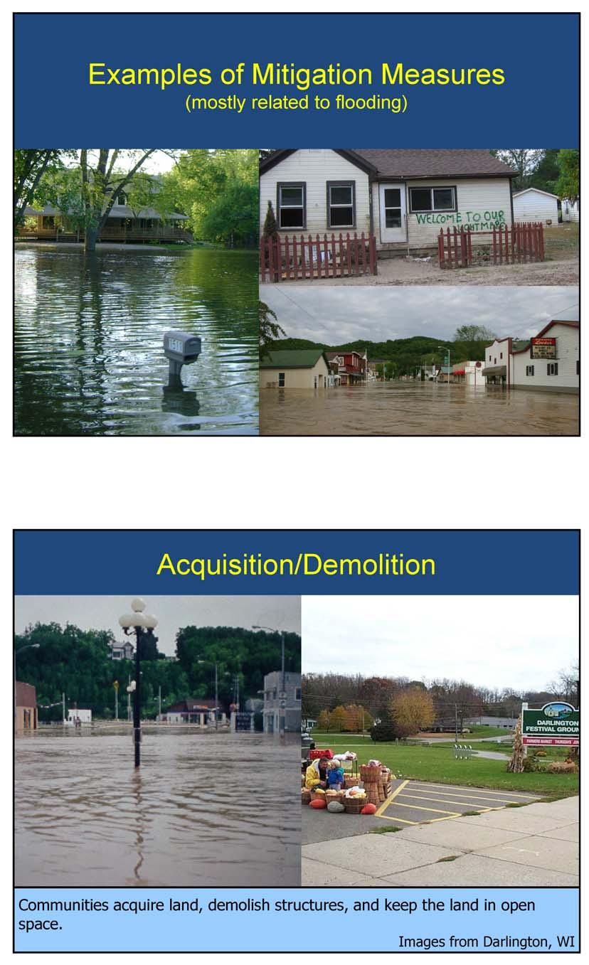
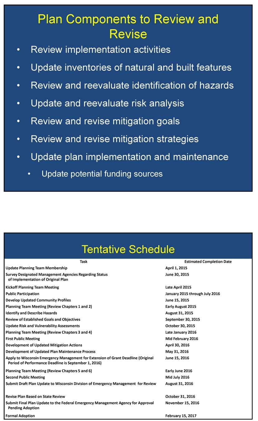
2 -2- planning team that he anticipates that there will be four meetings of the team throughout the Plan updating process. At the request of Lt. Benn, the team members introduced themselves. OVERVIEW OF HAZARD MITIGATION AND HAZARD MITIGATION PLAN UPDATING PROCESS Lt. Benn introduced Joseph Boxhorn, Senior Planner, Southeastern Wisconsin Regional Planning Commission (SEWRPC). Mr. Boxhorn presented an overview of hazard mitigation and the hazard mitigation plan updating process. [Secretary s Note: A copy of Mr. Boxhorn s presentation is attached herein as Exhibit A.] OVERVIEW OF THE ONGOING BUYOUTS OF FLOODPRONE BUILDINGS ALONG THE FOX RIVER IN KENOSHA COUNTY Mr. Boxhorn introduced John Meland, SEWRPC Principal Specialist. At Mr. Boxhorn s request, Mr. Meland presented an overview of Kenosha County s ongoing Fox River buyout program for flood prone buildings. Mr. Meland stated that when the program began in 1995, there were 175 flood prone structures located in the floodplain along the Fox River between Wheatland and Silver Lake. He added that the buyout program has received 11 million dollars in grant funds and that 103 residential properties representing 160 tax parcels have been voluntarily sold to the County and demolished. Mr. Meland explained that funds are currently exhausted and no more funds will be available for buyouts unless there is a federally declared disaster in the County. He noted that 72 flood prone residential properties currently remain in the project area. He indicated that one repetitive loss property was also purchased on Camp Lake in January 2015 with funding from the FEMA Flood Mitigation Assistance Program. Mr. Popanda asked who retains ownership of the properties after the buildings had been removed. Mr. Meland replied that Kenosha County now owns the parcels. Lt. Benn indicated that there are privately-owned parcels located in the project area that have no structures on them. He noted that despite the fact that these parcels are unbuildable the owners are unwilling to sell them. Lt. Benn suggested these parcels could become parkland. Mr. Meland replied that FEMA will not pay for the acquisition of vacant land and noted that the only way for the County to acquire those parcels is through donation to the County by the owners. Mr. Meland added that FEMA requires that parcels acquired using funding from FEMA grant programs remain in open space land uses. Mr. Treloar responded that his office has sent letters to the owners of all the vacant parcels in the project area explaining that they have the option to donate these properties to the County. Mr. Treloar added that the letters also explain that such a donation would free the owners of the property tax obligations associated with the properties. He noted that four property owners have expressed interest. BACKGROUND ON THE SECOND UPDATE OF THE KENOSHA COUNTY HAZARD MITIGATION PLAN Mr. Boxhorn presented background information on the initial hazard mitigation plan and the first update to the plan. He noted that the initial plan was completed in 2005 and the first plan update was completed in Mr. Boxhorn also outlined the main plan components to be reviewed and revised, presented a work schedule for the plan update, and explained the role of the Local Planning Team in the plan development process. He stated that a project webpage has been created on the SEWRPC website. He indicated that draft chapters of the plan report, meeting materials, and summary notes from planning team meetings will be available on this page. He added that a comment screen is also available on this webpage through which planning team members and members of the public may submit questions or comments on the draft plan.
3 -3- Lt. Benn asked whether data can be uploaded onto the website. Mr. Boxhorn explained that the website comment screen was mainly for questions and comments and suggested that it would be best to him any data pertaining to the plan. [Secretary s Note: As previously noted, Mr. Boxhorn s presentation is attached herein as Exhibit A. A copy of the proposed work schedule for the plan update is attached herein as Exhibit B.] REVIEW OF HAZARD MITIGATION GOALS FROM FIRST PLAN UPDATE Mr. Boxhorn presented an overview of the goals that were established for the initial Kenosha County hazard mitigation planning program and revised during the first update of the plan. He asked the Team to review the goals and to begin to think about any changes and/or additions that may be necessary. [Secretary s Note: A copy of the hazard mitigation goals is attached herein as Exhibit C.] HAZARD AND VULNERABILITY ASSESSMENT EXERCISE Mr. Boxhorn stated that as part of the hazard and vulnerability analysis for the plan, it will be necessary to decide which hazards will be addressed by the plan. He indicated that a hazard and vulnerability assessment tool and instructions for completing the tool were included with the agenda for this meeting. He explained that the tool is a modified version of a tool developed by Kaiser Permanente for assessing the risks faced by healthcare facilities. [Secretary s Note: A copy of the hazard and vulnerability assessment tool and the instructions for completing the tool are attached herein as Exhibit D.] Mr. Boxhorn asked the members of the Local Planning Team to complete the hazard and vulnerability assessment tool. He explained that the results of this exercise would be used to help determine which hazards are addressed by the hazard mitigation plan update. Mr. Arbet asked whether the assessment tool should be completed utilizing their experience in their own communities or through their perception of the entire County. Mr. Boxhorn replied that their assessment should be applicable to the entire County. Mr. Popanda, suggested that each team member should complete the assessment based upon the areas that they know and represent, noting that to do otherwise could cause the results to be skewed. Mr. Boxhorn noted that the assessment results will not be the only information used to identify the hazards faced by the County. Lt. Benn suggested that people fill out the survey based on the community they represent and record the name of the community on the worksheet. Mr. Boxhorn agreed. ADJOURNMENT There being no further business, the meeting was adjourned by unanimous consent at 10:20 a.m. CAPR SUMMARY NOTES KENOSHA CTY HMP LPT MTG APRIL ( ).DOC LLK/JEB/AWO/MAB/pk 05/15/15

4 Exhibit A

5

6

7
8

9

10
11

12

13

14

15

16

17

18

19

20

21
22

23

24

25

26
27 Exhibit B Attachment 1 PROPOSED WORK SCHEDULE FOR UPDATING THE KENOSHA COUNTY HAZARD MITIGATION PLAN Task Estimated Completion Date Update Planning Team Membership April 1, 2015 Survey Designated Management Agencies Regarding Status June 30, 2015 of Implementation of Original Plan Kickoff Planning Team Meeting Late April 2015 Public Participation January 2015 through July 2016 Develop Updated Community Profiles June 15, 2015 Planning Team Meeting (Review Chapters 1 and 2) Early August 2015 Identify and Describe Hazards August 31, 2015 Review of Established Goals and Objectives September 30, 2015 Update Risk and Vulnerability Assessments October 30, 2015 Planning Team Meeting (Review Chapters 3 and 4) Late January 2016 First Public Meeting Mid February 2016 Development of Updated Mitigation Actions April 30, 2016 Development of Updated Plan Maintenance Process May 31, 2016 Apply to Wisconsin Emergency Management for Extension of Grant Deadline (Original Period of Performance Deadline is September 1, 2016) June 15, 2016 Planning Team Meeting (Review Chapters 5 and 6) Early June 2016 Second Public Meeting Mid July 2016 Submit Draft Plan Update to Wisconsin Division of Emergency Management for Review August 31, 2016 Revise Plan Based on State Review October 31, 2016 Submit Final Plan Update to the Federal Emergency Management Agency for Approval Pending Adoption November 15, 2016 Formal Adoption February 15, 2017 Anticipated Period of Performance Deadline March 1, 2017 # DOC KRY/MGH/JEB/AWO/pk 03/11/15
28 Exhibit C Attachment 2 HAZARD MITIGATION GOALS AND OBJECTIVES FOR KENOSHA COUNTY HAZARD MITIGATION PLAN The following goals were established for the initial Kenosha County hazard mitigation planning program, 1 based, in part, upon goals previously established in watershed, park and open space, and land use planning programs. 1. Land Use: A spatial distribution of the various land uses that minimizes hazards and dangers to health, welfare, and safety, as well as further enhancing the economic base of the County, and will result in a compatible arrangement of land uses properly related to the existing and proposed supporting transportation, utility, public safety systems, and public facility systems. 2. Natural Resources: A spatial distribution of the various land uses which maintains biodiversity and will result in the protection and wise use of the natural resources of the County, including its soils, inland lakes and streams, groundwater, wetlands, woodlands, wildlife, and natural areas and critical species habitats. 3. Transportation: An integrated transportation system that, through its location, capacity, and design, will safely, economically, and effectively serve the existing and proposed land use pattern and promote the implementation of the land use plan, meeting the current and anticipated travel demand and minimizing the potential for accidents and the associated toll on life and property damage. 4. Fire, Police, and Emergency Medical Services: The provision of facilities necessary to maintain a high quality of fire and police protection and emergency medical services throughout the County. 5. Stormwater and Floodland Management: The development of a stormwater and floodland management system that reduces the exposure of people to drainage- and flooding-related inconvenience and to health and safety hazards and that reduces the exposure of real and personal property to damage through inundation resulting from flooding and inadequate stormwater drainage. 6. Lake Michigan Coastal Erosion: The identification of high erosion risk Lake Michigan shoreline areas and the development of a coastal erosion control program that reduces the exposure of people and real and personal property to shoreline erosion and bluff recession. 7. Unpredictable Hazards: The identification and development of programs that complement County and local emergency operations plans to mitigate the potential exposure to health and safety and the exposure of real and personal property resulting from a broad range of hazards which are unpredictable and not geographically specific in nature. 8. Communications: Communications interoperability throughout the County amongst all First Responders, so as to be able to quickly and effectively respond to any incident to prevent the loss of life and to save property. # DOC JEB 03/31/15 1 SEWRPC Community Assistance Planning Report No. 278, Kenosha County Hazard Mitigation Plan Update: (2nd Edition), June 2010.
29 Exhibit D INSTRUCTIONS FOR COMPLETING HAZARD VULNERABILITY AND ASSESSMENT TOOL The purpose of this Hazard Vulnerability and Assessment Tool is to evaluate the potential that specific hazards may occur, the likely severity of impacts resulting from these hazards, and the extent to which these impacts may be mitigated by current levels of preparedness. The tool uses estimates of probability of occurrence, likely severity of impacts, and level of preparedness to estimate the risk posed by each hazard. Please address all of the potential threats that are listed. Instructions for completing entries in each column are given below. Probability For each of the listed hazards, please indicate the likelihood that it will occur, with 1 indicating a low probability of occurrence, 2 indicating a moderate probability of occurrence, and 3 indicating a high probability of occurrence. Issues to consider for probability include, but are not limited to: Known risk, Historical data and experience, and Local government or agency experience. Human Impacts For each of the listed hazards, please indicate what you consider to be the likely level of impacts to human life if the hazard occurs, with 1 indicating a low level of impacts, 2 indicating a moderate level of impacts, and 3 indicating a high level of impacts. Issues to consider for human impacts include, but are not limited to: Potential of the hazard to cause death, and Potential of the hazard to cause injury requiring medical treatment. Property Impacts For each of the listed hazards, please indicate the likely level of physical losses and damages to property if the hazard occurs, with 1 indicating a low level of losses and damages, 2 indicating a moderate level of losses and damages, and 3 indicating a high level of losses and damages. Issues to consider for property impacts include, but are not limited to: The potential of the hazard to cause damage to property or crops, The cost to replace damaged property, The cost to set up a temporary replacement for damaged property, The cost to repair damaged property, and The time to recover from the property damage. Business and Government Agency Impacts For each of the listed hazards, please indicate what the likely level of impacts to the operations of businesses and government agencies is if the hazard occurs, with 1 indicating a low level of impacts, 2 indicating a moderate level of impacts, and 3 indicating a high level of impacts. Issues to consider for business impacts include, but are not limited to: Business or agency interruption, Employees unable to report to work, Customers or clients unable to reach facility, Company or agency in violation of contractual agreements, Imposition of fines and penalties or legal costs, Interruption of access to critical supplies,
30 Interruption of product or service distribution, Financial impact or burden, and Interruption of critical care and emergency services. Preparedness For each of the listed hazards, please indicate the current level of preparedness for dealing with the hazard and its impacts, with 1 indicating a high level of preparedness, 2 indicating a moderate level of preparedness, and three indicating a low level of preparedness or no preparedness. Issues to consider for preparedness include, but are not limited to: The status of current plans that address the hazard, The frequency of drills that address the hazard, The status of training related to the hazard and its impacts, Insurance, The availability of back-up systems, and The availability of community resources. This survey will be compiled and the results will be reported during the hazard identification phase of developing or updating the hazard mitigation plan. # DOC JEB 03/30/15
31 Exhibit D (continued) Attachment 3 HAZARD AND VULNERABILITY ASSESSMENT TOOL KENOSHA COUNTY HAZARD MITIGATION PLAN UPDATE EVENT SCORE PROBABILITY Likelihood This Will Occur 0 = N/A 1 = Low 2 = Moderate 3 = High HUMAN IMPACT Possibility of Death or Injury 0 = N/A 1 = Low 2 = Moderate 3 = High SEVERITY = (MAGNITUDE - MITIGATION) PROPERTY IMPACT Physical Losses and Damages 0 = N/A 1 = Low 2 = Moderate 3 = High BUSINESS AND AGENCY IMPACT PREPAREDNESS RISK Interruption of Services 0 = N/A 1 = Low 2 = Moderate 3 = High Preplanning 0 = N/A 1 = High 2 = Moderate 3 = Low or none Relative Threat* A1. Riverine flooding 0% A2. Stormwater flooding 0% A3. Lake flooding 0% A4. Tornado 0% A5. Earthquake 0% A6. Thunderstorm 0% A7. High straight-line wind 0% A8. Lightning 0% A9. Hail 0% A10. Heavy snow storm 0% A11. Blizzard 0% A12. Ice storm 0% A13. Extreme cold 0% A14. Extreme heat 0% A15. Drought 0% A16. Fog 0% A17. Dust storm 0% A18. Lake Michigan Erosion B1. Contamination or loss of water supply system 0% B2. Loss of sewerage system 0% B3. Loss of telecommunication 0% B4. Electrical system outage 0% B5. Computer system incident/cyber attack 0% C1. Hazardous materials railroad incidents 0% C2. Hazardous materials roadway incidents 0% C3. Hazardous materials pipeline incidents 0% C4. Hazardous materials fixed facility incidents (industries, bulk fuel storage sites, grain elevators, agricultural chemical storage, and explosives, including fireworks storage) D1. Railroad transportation accidents 0% D2. Roadway transportation accidents 0% D3. Aviation accidents 0% E1. Correctional center incidents 0% E2. Civil unrest 0% E3. Terrorism incidents (bomb threats, hostage situations, biological incidents) E4. Workplace violence 0% E5. School violence 0% F1. Communicable disease outbreak or epidemic 0% F2. Large-scale food contamination 0% G1. Wildfire 0% G2. Large structure fires 0% G3. Explosions 0% G4. Mass casualty incidents 0% G5. Building collapse or cave-in 0% H1. Dam failure 0% H2. Landslide 0% H3. Land subsidence 0% *Threat increases with percentage. AVERAGE SCORE % 0-100% 0% 0% Source: Kaiser Permanente and SEWRPC. RISK = PROBABILITY * SEVERITY Shaded hazards are profiled in the current Kenosha County hazard mitigation plan. # JEB/pk 04/07/15
SUMMARY NOTES OF THE FEBRUARY 13, 2018 MEETING OF THE OZAUKEE COUNTY HAZARD MITIGATION PLAN LOCAL PLANNING TEAM
 SUMMARY NOTES OF THE FEBRUARY 13, 2018 MEETING OF THE OZAUKEE COUNTY HAZARD MITIGATION PLAN LOCAL PLANNING TEAM INTRODUCTION The February 13, 2018 meeting of the Ozaukee County Hazard Mitigation Plan Local
SUMMARY NOTES OF THE SEPTEMBER 28, 2009, MEETING OF THE KENOSHA COUNTY HAZARD MITIGATION TASK FORCE
 SUMMARY NOTES OF THE SEPTEMBER 28, 2009, MEETING OF THE KENOSHA COUNTY HAZARD MITIGATION TASK FORCE INTRODUCTION The first meeting of the Kenosha County Hazard Mitigation Task Force was convened at the
FACILITY NAME. CONSIDERATIONS FOR COMPLETING THE ANALYSIS FORMS The following instructions were modified from the Kaiser Permanente HVA tool
 FACILITY NAME CONSIDERATIONS FOR COMPLETING THE ANALYSIS FORMS The following instructions were modified from the Kaiser Permanente HVA tool 1) Change "Facility Name" at the top of this Instruction Tab
Section II: Vulnerability Assessment and Mitigation
 Section II: Vulnerability Assessment and Mitigation 1. Hazard Vulnerability Analysis (facility name) should conduct a thorough Hazard Vulnerability Analysis to help determine what events or incidents may
Southwest Florida Healthcare Coalition
 Southwest Florida Healthcare Coalition Hazards Vulnerability Assessment 2018 1 Table of Contents Summary 3 EmPower Maps and Data 5 Social Vulnerability Index Maps 19 Suncoast Disaster Healthcare Coalition
Hazard Mitigation Planning
 Hazard Mitigation Planning Mitigation In order to develop an effective mitigation plan for your facility, residents and staff, one must understand several factors. The first factor is geography. Is your
Multi-Jurisdictional Hazard Mitigation Plan. Data Collection Questionnaire. For School Districts and Educational Institutions
 Multi-Jurisdictional Hazard Mitigation Plan Data Collection Questionnaire For School Districts and Educational Institutions County: School District / Educational Institution Name: Return by: Please complete
Town of Montrose Annex
 Town of Montrose Annex Community Profile The Town of Montrose is located in the Southwest quadrant of the County, east of the Town of Primrose, south of the Town of Verona, and west of the Town of Oregon.
APPENDIX D PLANNING PROCESS DOCUMENTATION
 APPENDIX D PLANNING PROCESS DOCUMENTATION This appendix includes the following: 1. Meeting Agendas 2. Meeting Minutes 3. Meeting Sign-In Sheets 4. Public Survey Summary Results 1) Introductions AGENDA
Village of Blue Mounds Annex
 Village of Blue Mounds Annex Community Profile The Village of Blue Mounds is located in the southwest quadrant of the County, north of the town of Perry, west of the town of Springdale, and south of the
Multi-Jurisdictional Hazard Mitigation Plan. Data Collection Questionnaire. For Local Governments
 Multi-Jurisdictional Hazard Mitigation Plan Data Collection Questionnaire County: For Local Governments Jurisdiction: Return to: Marcus Norden, Regional Planner BRP&EC Please complete this data collection
HAZARD MITIGATION PLANNING
 HAZARD MITIGATION PLANNING Oswego County HMP Update Working Group Kickoff Meeting September 27, 2017 Agenda Welcoming Remarks Oswego County Emergency Management DHSES FEMA Introduce Executive Committee
Natural Hazards Risks in Kentucky. KAMM Regional Training
 Natural Hazards Risks in Kentucky KAMM Regional Training Floodplain 101 Kentucky has approximately 92,000 linear miles of streams and rivers Approximately 31,000 linear miles have mapped flood hazards
GUIDE BUSINESS & INDUSTRY A STEP-BY-STEP APPROACH TO EMERGENCY PLANNING, RESPONSE AND RECOVERY FOR COMPANIES OF ALL SIZES
 GUIDE EMERGENCY MANAGEMENT GUIDE FOR BUSINESS & INDUSTRY A STEP-BY-STEP APPROACH TO EMERGENCY PLANNING, RESPONSE AND RECOVERY FOR COMPANIES OF ALL SIZES Sponsored by a Public-Partnership with the Federal
Prerequisites for EOP Creation: Hazard Identification and Assessment
 Prerequisites for EOP Creation: Hazard Identification and Assessment Presentation to: Advanced Healthcare Emergency Management Course Objectives Upon lesson completion, you should be able to: Understand
COMMUNITY SUMMARY LINN COUNTY MULTI-JURISDICTIONAL HAZARD MITIGATION PLAN CITY OF LISBON
 COMMUNITY SUMMARY LINN COUNTY MULTI-JURISDICTIONAL HAZARD MITIGATION PLAN CITY OF LISBON This document provides a summary of the hazard mitigation planning information for the City of Lisbon that will
Emergency Preparedness. Emergency Preparedness & the Senior Housing Provider. The Speakers LEGAL REQUIREMENTS
 Emergency Preparedness & the Senior Housing Provider LEADINGAGE MINNESOTA 2015 SENIOR LIVING NOW! CONFEREN CE SESSIONS #107 AND #207 The Speakers Andrew Tepfer All-Hazard Planner Homeland Security & Emergency
Natural Hazard Mitigation Plan 5-Year Update Progress Report Chippewa County Taskforce Committee January 29, 2013
 Natural Hazard Mitigation Plan 5-Year Update Progress Report Chippewa County Taskforce Committee January 29, 2013 Allegan County, June, 2010 Photo courtesy Peter Olson Chapter Updates Chapter 1 Introduction»
Hazard Vulnerability Assessment for Long Term Care Facilities
 Hazard Vulnerability Assessment for Long Term Care Facilities Dave Seebart WHEPP Reg. 3, Project Manager April 23, 25, & 26, 2013 1 Hazard Vulnerability Assessment (HVA) for Long Term Care Facilities (LTCF)
SOUTH CENTRAL REGION MULTI-JURISDICTION HAZARD MITIGATION PLAN. Advisory Committee Meeting September 12, 2012
 SOUTH CENTRAL REGION MULTI-JURISDICTION HAZARD MITIGATION PLAN Advisory Committee Meeting September 12, 2012 AGENDA FOR TODAY Purpose of Meeting Engage All Advisory Committee Members Distribute Project
Appendix F: Ozark special Road District Addendum
 Appendix F: Ozark special Road District Addendum F-1: Introduction and Planning Process F-1.1 Purpose The Christian County 2016 Multi-Jurisdictional Natural Hazards Mitigation Plan is an updated version
Evaluate every potential event in each of the three categories of probability, risk, and preparedness. Add additional events as necessary.
 HAZARD VULNERABILITY ANALYSIS The Joint Commission defines hazard vulnerability analysis as the identification of hazards and the direct and indirect effect these hazards may have on the hospital. Hazard
Planning Process Documentation
 Appendix D Planning Process Documentation This appendix includes: 1. Meeting Agendas 2. Meeting Minutes 3. Meeting Sign-In Sheets AGENDA Wake County Multi-Jurisdictional Hazard Mitigation Plan West Wake
Assessing Risk: Shifting Focus from Hazards to Capabilities. Jane Coolidge Kara Walker CMRHCC April 2017
 Assessing Risk: Shifting Focus from Hazards to Capabilities Jane Coolidge Kara Walker CMRHCC April 2017 Hazards Vulnerability Analysis (HVA): Overview To identify jurisdictional hazards To assess hazard
COMMUNITY SUMMARY LINN COUNTY MULTI-JURISDICTIONAL HAZARD MITIGATION PLAN CITY OF CENTRAL CITY
 COMMUNITY SUMMARY LINN COUNTY MULTI-JURISDICTIONAL HAZARD MITIGATION PLAN CITY OF CENTRAL CITY This document provides a summary of the hazard mitigation planning information for the City of Central City
VULNERABILITY ASSESSMENT
 SOUTHSIDE HAMPTON ROADS HAZARD MITIGATION PLAN VULNERABILITY ASSESSMENT 2011 UPDATE Each of the hazards in this section was reviewed and updated to reflect the revised information obtained for the updated
LOCAL HAZARD MITIGATION PLAN REVIEW WORKSHEET FEMA REGION 2 Jurisdiction: Jurisdiction: Title of Plan: Date of Plan: Address:
 REVIEW AD APPROVAL TATU Title of Plan: Date of Plan: Local Plan submitted by: Address: Title: Agency: Phone umber: E-Mail: tate Reviewer: Title: Date: FEMA Reviewer: Title: Date: FEMA QA/QC: Title: Date:
Dade County Natural Hazard Mitigation Plan
 Introduction to Mitigation Definition of Mitigation Mitigation is defined by FEMA as "...sustained action that reduces or eliminates longterm risk to people and property from natural hazards and their
G318 Local Mitigation Planning Workshop. Module 2: Risk Assessment. Visual 2.0
 G318 Local Mitigation Planning Workshop Module 2: Risk Assessment Visual 2.0 Unit 1 Risk Assessment Visual 2.1 Risk Assessment Process that collects information and assigns values to risks to: Identify
Sussex County All Hazard Mitigation Plan. Plan Executive Summary
 Sussex County All Hazard Mitigation Plan Plan Executive Summary March 2010 SUSSEX COUNTY ALL HAZARD MITIGATION PLAN SUMMARY March 2010 For questions and to make comments on this document, contact: Joseph
Northern Kentucky University 2018 Hazard Mitigation Plan. Public Kick-Off Meeting March 20, 2018
 Northern Kentucky University 2018 Hazard Mitigation Plan Public Kick-Off Meeting March 20, 2018 Agenda Welcome Hazard Mitigation Planning 101 Hazard Identification Exercises Next Steps Jeff Baker, NKU
APPENDIX H TOWN OF FARMVILLE. Hazard Rankings. Status of Mitigation Actions. Building Permit Data. Future Land Use Map. Critical Facilities Map
 APPENDIX H TOWN OF FARMVILLE Hazard Rankings Status of Mitigation Actions Building Permit Data Future Land Use Map Critical Facilities Map Zone Maps Hazard Rankings (From Qualitative Assessment and Local
Tangipahoa Parish Hazard Mitigation Plan Update Mitigation Steering Committee Kick-off Meeting. September 9, 2014 Hammond, LA
 Tangipahoa Parish Hazard Mitigation Plan Update Mitigation Steering Committee Kick-off Meeting September 9, 2014 Hammond, LA Introductions Officials Mitigation Steering Committee members SDMI team members
A Practical Framework for Assessing Emerging Risks
 A Practical Framework for Assessing Emerging Risks John Bowman, MBCI Enterprise Business Continuity Management Share one approach to assess the current level of business continuity risk in your organization.
DeSoto Parish Hazard Mitigation Plan Update Kick-off Meeting. February 16, 2016 Grand Cane, LA
 DeSoto Parish Hazard Mitigation Plan Update Kick-off Meeting February 16, 2016 Grand Cane, LA Introductions Officials Mitigation Steering Committee members SDMI team members GOHSEP hazard mitigation team
VULNERABILITY ASSESSMENT
 SOUTHSIDE HAMPTON ROADS HAZARD MITIGATION PLAN VULNERABILITY ASSESSMENT INTRODUCTION The Vulnerability Assessment section builds upon the information provided in the Hazard Identification and Analysis
Somerset County Mitigation Plan Update
 Somerset County Multi-Jurisdictional Hazard Mitigation Plan Update Kickoff Meeting Agenda Kickoff Meeting September 28, 2017 6:00 pm SCES, 402 Roycefield Road, Hillsborough, NJ Welcome and Opening Remarks.....
On Page 4, following the Planning Process subsection, insert the following: 2012 Committee members included:
 Appendix C: City of Estacada Addendum to the Clackamas County Natural Hazards Mitigation Plan 2012 Amendments and Update The Oregon Partnership for Disaster Resilience prepared this Appendix to the City
EvCC Emergency Management Plan ANNEX #11 Hazard Assessment
 1. INTRODUCTION The risk and vulnerability assessment process detailed here identifies the hazards the Evict Campus faces and assesses the level of vulnerability to these potential events. Conducting a
LOCAL MITIGATION PLAN REVIEW CROSSWALK
 INSTRUCTIONS FOR USING THE PLAN REVIEW CROSSWALK FOR REVIEW OF LOCAL MITIGATION PLANS Attached is a Plan Review Crosswalk based on the Local Multi-Hazard Mitigation Planning Guidance, published by FEMA
Town of Pleasant Springs Annex
 Town of Pleasant Springs Annex Community Profile The Town of Pleasant Springs is located in the southeast quadrant of Dane County, west of the Town of Christiana, north of the town of Dunkirk, and east
CHAPTER THREE Natural Hazard Mitigation Strategy
 CHAPTER THREE Natural Hazard Mitigation Strategy Chapter 3 Section All Sections Updates to Section Revised Natural Hazards Introduction and all Sections to change Natural Hazards Subcommittee to Committee.
Justification for Floodplain Regulatory Standards in Illinois
 Justification for Floodplain Regulatory Standards in Illinois Office of Water Resources Issue Paper April, 2015 Proactive Illinois floodplain and floodway regulatory standards have prevented billions of
9.35 VILLAGE OF TULLY
 9.35 VILLAGE OF TULLY This section presents the jurisdictional annex for the Village of Tully. A.) HAZARD MITIGATION PLAN POINT OF CONTACT Primary Point of Contact Elizabeth L. Greenwood, Mayor 5833 Meetinghouse
Osceola County Hazard Mitigation Plan. Part 3 - Mitigation Strategy
 Osceola County Hazard Mitigation Plan Part 3 - Mitigation Strategy Osceola County Hazard Mitigation Plan - Part 3 Mitigation Strategy 3-1 Contents Tables and Figures... 3 Overview... 4 Strategy... 4 Goals...
Garfield County NHMP:
 Garfield County NHMP: Introduction and Summary Hazard Identification and Risk Assessment DRAFT AUG2010 Risk assessments provide information about the geographic areas where the hazards may occur, the value
EXECUTIVE SUMMARY. Onondaga County Multi-Jurisdictional Planning Process
 EXECUTIVE SUMMARY The Onondaga County Multi-Jurisdictional All-Hazards Mitigation Plan was prepared in response to the Disaster Mitigation Act of 2000 (DMA 2000). DMA 2000 requires states and local governments
in coordination with Peoria County, Planning and Zoning Department
 Prepared by Amec Foster Wheeler Environment & Infrastructure Hazard Mitigation and Emergency Management Program in coordination with Peoria County, Planning and Zoning Department The purpose of hazard
2. Hazards and risks 2. HAZARDS AND RISKS. Summary
 2. Hazards and risks Summary The National CDEM Plan identifies core functions for national management of the consequences of civil defence emergencies. It may also address the management of consequences
Meeting Date Time Location Attendees Purpose
 MEETING NOTES Meeting Bedford County Hazard Mitigation Plan Planning Team Kickoff Meeting Date October 19, 2016 Time 7:00-8:40 p.m. Location Bedford Elementary School, 3639 Business 220, Bedford, PA Donald
Risk Assessment Planning Team Meeting April 5, 2016
 Risk Assessment Planning Team Meeting April 5, 2016 Welcome and Introductions Project Overview & Kickoff Meeting Summary Capability Assessment, Evaluation of Identified Hazards & Risks, NFIP Review Risk
ITEM 9 STAFF REPORT. TO: Mayor and City Council. FROM: Tom Welch, Interim Fire Chief. SUBJECT: City ofmill Valley All-Hazard Mitigation Plan
 STAFF REPORT TO: Mayor and City Council FROM: Tom Welch, Interim Fire Chief SUBJECT: City ofmill Valley DATE: March 2,2015 Approved for Forwarding: ~c.~~_ a es C. McCann, City Manager 1 Issue: Consideration
Key Fundamentals of Flood Insurance in the NFIP!
 a Welcome to Key Fundamentals of Flood Insurance in the NFIP! A Before and After approach for Housing Counselors Presented by: 1 Before the Flood Presenter Melanie Graham After the Flood Presenter Erin
FREQUENTLY ASKED QUESTION ABOUT FLOODPLAINS Michigan Department of Environmental Quality
 FREQUENTLY ASKED QUESTION ABOUT FLOODPLAINS Michigan Department of Environmental Quality WHAT IS A FLOOD? The National Flood Insurance Program defines a flood as a general and temporary condition of partial
ANNEX F REQUIRED PLANNING DOCUMENTATION CHATHAM COUNTY MULTI-JURISDICTION PRE-DISASTER HAZARD MITIGATION PLAN DECEMBER 2015
 ANNEX F REQUIRED PLANNING DOCUMENTATION CHATHAM COUNTY MULTI-JURISDICTION PRE-DISASTER HAZARD MITIGATION PLAN DECEMBER 2015 Chatham County Pre-Disaster Hazard Mitigation Plan Annexes F-1 THIS PAGE INTENTIONALLY
Community Rating System. National Flood Insurance Program
 National Flood Insurance Program Community Rating System A Local Official s Guide to Saving Lives Preventing Property Damage Reducing the Cost of Flood Insurance FEMA B-573 / May 2015 How the Community
Executive Summary. Introduction and Purpose. Scope
 Executive Summary Introduction and Purpose This is the first edition of the Los Angeles Unified School District All-Hazard Mitigation Plan, and through completion of this plan the District continues many
Stevens County, Washington Request for Proposal For A Countywide Multi-Jurisdictional All Hazard Mitigation Plan (Update)
") Stevens County, Washington Request for Proposal For A Countywide Multi-Jurisdictional All Hazard Mitigation Plan (Update) Project background A Multi-Jurisdictional All Hazard Mitigation Plan is a representation
Stevens County, Washington Request for Proposal For A Countywide Multi-Jurisdictional All Hazard Mitigation Plan (Update) Project background A Multi-Jurisdictional All Hazard Mitigation Plan is a representation
T-318. Hazard Mitigation Section TDEM Recovery, Mitigation, and Standards
 T-318 Local Hazard Mitigation Plan Requirements Hazard Mitigation Section TDEM Recovery, Mitigation, and Standards Raymond Mejia, Lead Hazard Mitigation Planner Samantha Aburto, Hazard Mitigation Planner
HAZARD MITIGATION PLAN POINT OF CONTACT MUNICIPAL PROFILE
 HAZARD MITIGATION PLAN POINT OF CONTACT northcatasauquaema@yahoo.com scheirerg@gmail.com MUNICIPAL PROFILE MUNICIPAL PARTICIPATION Compliance with the National Flood Insurance Program (NFIP) Identify source
1 Rare Hazard event is not likely to occur within 100 years. 2 Occasional Hazard event is likely to occur within 100 years
 5.3 HAZARD RANKING After the hazards of concern were identified for Onondaga County, the hazards were ranked to describe their probability of occurrence and their impact on population, property (general
Natural Hazards Mitigation Plan Kankakee County, Illinois Executive Summary
 1. Introduction Natural Hazards Mitigation Plan Kankakee County, Illinois Executive Summary Kankakee County is subject to natural hazards that threaten life, safety, health, and welfare and cause extensive
Planning Process---Requirement 201.6(b): An open public involvement process is essential to the development of an effective plan.
: An open public involvement process is essential to the development of an effective plan.") Section 3 Capability Identification Requirements Planning Process---Requirement 201.6(b): An open public involvement process is essential to the development of an effective plan. Documentation of the Planning
Section 3 Capability Identification Requirements Planning Process---Requirement 201.6(b): An open public involvement process is essential to the development of an effective plan. Documentation of the Planning
PLANNING PROCESS. Table of Contents. List of Tables
 PLANNING PROCESS Table of Contents 1.1 Narrative Description of the Planning Process... 1-1 1.2 Steering Committee & Public Involvement... 1-7 1.2.1 Steering Committee Participant Solicitation... 1-7 1.2.2
9.4 VILLAGE OF CAMILLUS
 9.4 VILLAGE OF CAMILLUS This section presents the jurisdictional annex for the Village of Camillus. A.) HAZARD MITIGATION PLAN POINT OF CONTACT Primary Point of Contact Kurt Brunger, Mayor 37 Main Street,
ANNEX B: TOWN OF BLUE RIVER
 ANNEX B: TOWN OF BLUE RIVER B.1 Community Profile Figure B.1 shows a map of the Town of Blue River and its location within Summit County. Figure B.1. Map of Blue River Summit County (Blue River) Annex
Planning Process---Requirement 201.6(b): An open public involvement process is essential to the development of an effective plan.
: An open public involvement process is essential to the development of an effective plan.") Section 3 Capability Identification Requirements Planning Process---Requirement 201.6(b): An open public involvement process is essential to the development of an effective plan. Documentation of the Planning
Section 3 Capability Identification Requirements Planning Process---Requirement 201.6(b): An open public involvement process is essential to the development of an effective plan. Documentation of the Planning
A.) HAZARD MITIGATION PLAN POINT OF CONTACT
 HAZARD MITIGATION PLAN POINT OF CONTACT") 9.6 TOWN OF CLAY This section presents the jurisdictional annex for the Town of Clay. A.) HAZARD MITIGATION PLAN POINT OF CONTACT Primary Point of Contact Mark Territo, Commissioner of Planning & Development
9.6 TOWN OF CLAY This section presents the jurisdictional annex for the Town of Clay. A.) HAZARD MITIGATION PLAN POINT OF CONTACT Primary Point of Contact Mark Territo, Commissioner of Planning & Development
a) Ensure public safety through reducing the threats to life and personal injury.
 Ensure public safety through reducing the threats to life and personal injury.") SECTION VII: FLOODPLAIN DISTRICT 7-1 Statement Of Purpose The purposes of the Floodplain District are to: a) Ensure public safety through reducing the threats to life and personal injury. b) Eliminate
SECTION VII: FLOODPLAIN DISTRICT 7-1 Statement Of Purpose The purposes of the Floodplain District are to: a) Ensure public safety through reducing the threats to life and personal injury. b) Eliminate
Priority Ranking. Timeframe. Faribault County Blue Earth, Bricelyn, Delavan, Easton, Elmore, Frost, Kiester, Minnesota Lake, Walters, Wells, Winnebago
 Multi-Hazard Plan, 2017 Table G - 1. Actions Identified by the () (From Master Action Chart) Action 1 All-Hazards 6 All-Hazards Education & Awareness Programs / Preparedness and Response Support Work to
STATE OF SOUTH CAROLINA
 STATE OF SOUTH CAROLINA STATEWIDE MUTUAL AID AGREEMENT FOR CATASTROPHIC DISASTER RESPONSE AND RECOVERY THIS AGREEMENT IS ENTERED INTO BETWEEN THE STATE OF SOUTH CAROLINA, EMERGENCY MANAGEMENT DIVISION,
HAZARD MITIGATION PLAN POINT OF CONTACT MUNICIPAL PROFILE
 HAZARD MITIGATION PLAN POINT OF CONTACT nazareth50em1@gmail.com jessicagteel@gmail.com MUNICIPAL PROFILE MUNICIPAL PARTICIPATION 3. Describe how the public will be engaged in the current planning process
Natural Hazards Mitigation Plan. Executive Summary
 Natural Hazards Mitigation Plan Executive Summary 1. Introduction Kane County Illinois, is subject to natural hazards that threaten life and health and have caused extensive property damage. Floods struck
Emergency Resilience Risk Assessment
 Emergency Resilience Assessment ANNEX 3 vember 2011 The Operating Framework for the NHS in England 2011/12 states: Emergency Preparedness and Resilience across the NHS continues to be a high priority.
Volusia County Floodplain Management Plan 2012
 Volusia County Floodplain Management Plan 2012 Introduction The National Flood Insurance Program (NFIP) provides federally supported flood insurance in communities that regulate development in floodplains.
Chapter 9 - Mitigation Strategies and Priorities
 Chapter 9 - Mitigation Strategies and Priorities The next step in the hazard mitigation planning process is to identify mitigation actions suitable to the community, evaluate the effect the action will
Otsego County Hazard Mitigation Plan (HMP) Risk Assessment Review Meeting Date November 14, 2018 Time 6:00 8:00 p.m.
 Risk Assessment Review Meeting Date November 14, 2018 Time 6:00 8:00 p.m.") MEETING NOTES Meeting Otsego County Hazard Mitigation Plan (HMP) Risk Assessment Review Meeting Date November 14, 2018 Time 6:00 8:00 p.m. Location Attendees Otsego County Board of Representatives Meeting
MEETING NOTES Meeting Otsego County Hazard Mitigation Plan (HMP) Risk Assessment Review Meeting Date November 14, 2018 Time 6:00 8:00 p.m. Location Attendees Otsego County Board of Representatives Meeting
MONTANA STATE PARKS INCIDENT MANAGEMENT PLAN TEMPLATE
 MONTANA STATE PARKS INCIDENT MANAGEMENT PLAN TEMPLATE Background and Objectives Parks and designated recreational areas administered by the Parks Division are subject to a variety of emergencies that pose
Multi-Hazard Risk Management Project The Smithsonian Institution (SI)
") Multi-Hazard Risk Management Project The Smithsonian Institution (SI) Over 700 facilities worldwide dedicated to research, exhibit, and outreach 18 museums and galleries in Washington DC and NYC wide variety
Multi-Hazard Risk Management Project The Smithsonian Institution (SI) Over 700 facilities worldwide dedicated to research, exhibit, and outreach 18 museums and galleries in Washington DC and NYC wide variety
Section 9. Emergency Management Accreditation Program
 Section 9. Emergency Management Accreditation Program 2014 Plan Update Changes The Emergency Management Accreditation Program is a new section. In the 2011 Plan, EMAP information was found following each
SMALL BUSINESS. Guide to Business. Continuity Planning. Ensure your business continues to operate in the event of a disruption.
 SMALL BUSINESS Guide to Business Continuity Planning Ensure your business continues to operate in the event of a disruption. You don t expect your home to burn down. However, you buy insurance to be prepared
Mitigation Strategies
 Mitigation Strategies Introduction Michigan State University Mitigation Goals Identification and Analysis of Mitigation Actions Recommendation and Prioritization of Mitigation Actions Potential Funding
Meeting Date/Time/Location
 Meeting Date/Time/Location Subject In Attendance Summary Prepared By Quorum Wednesday, October 28, 2015 from 1PM-3PM Confluence Technology Center, 285 Technology Center Way, Wenatchee, WA Flood Hazard
LOCAL HAZARD MITIGATION PLAN REVIEW FEMA REGION VI AND STATE OF TEXAS
 LOCAL HAZARD MITIGATION FEMA REGION VI AND STATE OF TEXAS Instructions for using the attached Crosswalk Reference Document for Review and Submission of Local Mitigation Action Plans to the State Hazard
Hillsborough County Local Mitigation Strategy and the Community Rating System
 Hillsborough County Local Mitigation Strategy and the Community Rating System Presented By Hillsborough County s Hazard Mitigation Section Eugene Henry, Manager Hazard Mitigation Contributing Team Members:
STATE AND LOCAL MITIGATION PLANNING how-to guide
 STATE AND LOCAL MITIGATION PLANNING how-to guide the hazard mitigation planning process Hazard mitigation planning is the process of determining how to reduce or eliminate the loss of life and property
EXECUTIVE SUMMARY. Greater Greenburgh Planning Area Planning Process
 EXECUTIVE SUMMARY The Greater Greenburgh Planning Area All-Hazards Mitigation Plan was prepared in response to the Disaster Mitigation Act of 2000 (DMA 2000). DMA 2000 requires states and local governments
7.0 RISK MANAGEMENT. Table of Contents
 Section 7 Risk Management 7.0 RISK MANAGEMENT Table of Contents 7.0 RISK MANAGEMENT... 1 7.1 Risk Management Process... 2 7.2 Audit and Risk Committee... 2 7.3 Risk Management Charter... 3 7.4 Council
Hazard Mitigation Plan Planning Perspective
 7. A. Hazard Mitigation Plan Planning Perspective B. Public Meeting Notice A. Hazard Mitigation Plan Planning Perspective York County Hazard Mitigation Plan Hazard Mitigation Plan Planning Perspective
Appendix E: Mitigation Action Worksheet Template
 This appendix provides the Action Worksheet template, including instructions for its completion, used by the participating jurisdictions to document applicable projects identified in their mitigation strategy,
Article 23-6 FLOODPLAIN DISTRICT
 AMENDING THE CODE OF THE CITY OF PITTSFIELD CHAPTER 23, ZONING ORDINANCE SECTION I That the Code of the City of Pittsfield, Chapter 23, Article 23-6 Floodplain District, shall be replaced with the following:
Introduction to Disaster Management
 Introduction to Disaster Management Definitions Adopted By Few Important Agencies WHO; A disaster is an occurrence disrupting the normal conditions of existence and causing a level of suffering that exceeds
REGIONAL HAZARD VULNERABILITY ANALYSIS REPORT
 9/8/2014 REGIONAL HAZARD VULNERABILITY ANALYSIS REPORT North Central Texas Trauma Regional Advisory Council TSA E 2 NCTTRAC REGIONAL HAZARD VULNERABILITY ANALYSIS REPORT The Regional Hazard Vulnerability
EMERGENCY MANAGEMENT
 -29- -30- -31- -32- EMERGENCY MANAGEMENT Plan and prepare for, respond to, and recover from natural and human made disasters in a coordinated response utilizing our local government and agency resources.
Local Hazard Mitigation Plan Review. FEMA Region VI and the State of Texas
 Appendix E: Local Hazard Mitigation Plan Review For FEMA Region VI and the State of Texas LOCAL HAZARD MITIGATION PLAN REVIEW FOR PAGE 1 FEMA REGION 6 AND STATE OF TEXAS FOR FEMA USE ONLY Instructions
MINUTES OF MEETING ALAMEDA COUNTY PLANNING COMMISSION MAY 4, 2009 (Approved May 18, 2009)
") FIELD TRIP: MINUTES OF MEETING MAY 4, 2009 (Approved May 18, 2009) MEMBERS PRESENT: Commissioners Kathie Ready and Richard Rhodes. MEMBERS EXCUSED: Commissioners Ken Carbone, Chair; Frank Imhof; Mike Jacob,
FIELD TRIP: MINUTES OF MEETING MAY 4, 2009 (Approved May 18, 2009) MEMBERS PRESENT: Commissioners Kathie Ready and Richard Rhodes. MEMBERS EXCUSED: Commissioners Ken Carbone, Chair; Frank Imhof; Mike Jacob,
9.12 VILLAGE OF FABIUS
 9.12 VILLAGE OF FABIUS This section presents the jurisdictional annex for the Village of Fabius. A.) HAZARD MITIGATION PLAN POINT OF CONTACT Primary Point of Contact Melanie Vilardi, Town Supervisor P.O.
Hazard Identification
 RISK OVERVIEW Hazard Identification... 1 Overview of Hazard Analysis... 4 HAZUS MH... 5 Statistical Risk Assessment Methodology... 5 Loss Estimates... 7 Vulnerability Essential Facilities, Infrastructure
HAZARD MITIGATION PLAN POINT OF CONTACT MUNICIPAL PROFILE
 HAZARD MITIGATION PLAN POINT OF CONTACT tatamy1@rcn.com dwerkheiser@tatamypa.com MUNICIPAL PROFILE MUNICIPAL PARTICIPATION Topic Identify source of information, if different from the one listed Additional