PLANNED DEVELOPMENT DISTRICT STANDARDS. Windhaven
|
|
|
- Deirdre Franklin
- 5 years ago
- Views:
Transcription
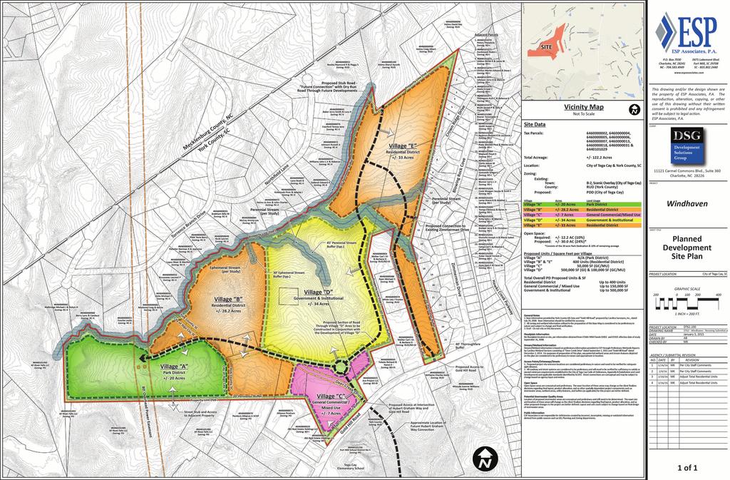
1 PLANNED DEVELOPMENT DISTRICT STANDARDS Windhaven A Mixed Use Planned Community 1. Statement of General Facts, Conditions and Objectives Property Size: Approximately Acres York County Tax Map # s: , , , , , , , and The development depicted on the Planned Development Site Plan is intended to reflect the general arrangement of proposed uses on the site. Final configuration, placement, and size of individual site elements may be altered or modified during design development and construction phases, within the limits of the City of Tega Cay Code of Ordinances or as otherwise established through the standards outlined in the Windhaven Planned Development District (PDD) Standards. The Petitioner reserves the right to modify the total number of units and uses identified within individual villages or phases, reallocate units from a village or phase to another, reconfigure street layouts, provided that the maximum density for the entire mixed use development does not exceed the maximum density permitted. These standards, as established by the Windhaven PDD Standards, as set out below and as depicted on the Planned Development Site Plan shall be followed in connection with development taking place on the site. 2. Land Use Designations and Standards for Development The land uses authorized for the Windhaven Development consist of: Park District Residential District (RD) General Commercial / Mixed Use (GC / MU) Government and Institutional District (GI) The following represents the respective requirements for the use and development of and within each designated land use area of Windhaven. Apartments are not permitted within the PDD. March 17, 2016 Windhaven PDD - 1
2 3. Overall PDD Density and Districts The overall density authorized for the Windhaven Development consists of: Residential Up to 400 Units consisting of a balanced mix of Single Family Detached, Patio Homes and Townhomes Commercial Up to 150,000 s.f. Government and Institutional Up to 500,000 s.f. Note: Residential units may be adjusted and interchanged between all villages and residential uses as long as the total project doesn t exceed a total of 400 total residential units within the boundary of the PDD. A. Park District Purpose: The general purpose of the park zoning district is to provide recreation and open space functions for the long-term benefit and enjoyment of city residents and adjacent neighborhoods. Permitted Uses: Within the Park District, a building or premises shall be used only for active or passive recreation and its associated uses and facilities. Development Standards: Notwithstanding development standards set forth elsewhere by this use category the minimum requirements within the Park District is as follows: 35 foot setback from adjacent residential uses Zero lot line setback from non-residential uses B. Residential District (RD) Purpose: This district is designed to permit a variety of residential uses at variable densities, based on the characteristics of such uses. Areas so designated are deemed suited to and with market potential for such uses. This designation is applied principally to undeveloped areas where unit and density flexibility will not adversely impact existing residential subdivisions, and where the housing market is sufficiently broad and flexible to meet the various consumer demands. Permitted Uses: Within RD District, a building or premises shall be used only for the following purposes: 1. Dwelling, single-family, detached. 2. Dwelling, single family attached (patio / townhomes). 3. Duplex, triplex, and quadriplex. 4. Schools, Government and Institutional uses. Public or private, offering general education courses and public utilities. 5. Neighborhood and community parks and centers, golf courses and similar uses. 6. Churches or similar places of worship, including parish houses, parsonages and convents. 7. Customary home occupations. 8. Subdivision sales office provided that: a. The use serves the subdivision in which it is located. March 17, 2016 Windhaven PDD - 2
3 b. A site plan is submitted; c. The use be terminated upon completion of the sale of ninety-five percent (95%) of the total number of homes and / or lots; provided, however, that a model or demonstration unit may be used for sales purposes until the last unit or lot is sold. Development Standards: Notwithstanding development standards set forth elsewhere by this use category, Table 1 summarizes the minimum requirements within the RD District. Additional development standards for this district are below: 1. Development will consist of up to 400 residential units as established in Table 1 and consist in a balanced mix of the following: a. Single Family Detached b. Patio Homes c. Townhomes 2. Maximum height of buildings will be three (3) stories, not to exceed 50 feet. 3. No more than one (1) separate maintenance building will be constructed per project site. 4. Detached lighting on the project site will be limited to 15 feet in height. All lighting fixtures will be full cut-off in nature, excluding lower, decorative lighting that may be installed along sidewalks, walking paths, and parking areas. 5. The project site must include access easements to greenways and trails when they exist on adjoining properties. 6. High quality amenities, appropriate to the density of the development, will be provided on project site to include but not limited to: a. A club house; b. A fitness facility for the residents of the community; c. A club room / recreational room; d. A pool and pool deck; and e. A formal landscape area with seating areas. 7. Surface parking lots shall not be permitted between the buildings and the adjacent public street or in the buffer area but should be located to the side and rear of the lot with building massing facing the public street to the greatest extent possible. 8. Internal streets shall have the option to be private but must meet design approval based on City standards. 9. Sidewalks will be provided along major thoroughfares to provide safe, continuous pedestrian linkages within the PDD and between adjacent developments. In addition, paved walkways will be provided within the project site to provide a connection between buildings, parking locations, and common spaces. 10. HVAC and related mechanical equipment, including roof top mechanical equipment if applicable, will be screened from public view at grade. 11. All new public utility transmission and distribution lines will be placed underground. 12. Cooling towers will not be allowed on the project site. 13. The following Architectural Standards shall apply: a. The building materials used on the principle buildings will be a combination of the following: brick, stone, precast stone, precast concrete, synthetic stone, cementatious siding (such as hardi-plank), stucco, or wood. Single Family Detached and Attached at least 35% of the front façade shall be exclusive of March 17, 2016 Windhaven PDD - 3
4 windows, doors and roofs, will be constructed of brick, stone and synthetic stone, precast stone or precast concrete. b. The principle buildings will include a variety of building solutions through the mixing of building profiles, elevations, and distinctive roof forms. c. The front façade of the principle buildings will be oriented towards the major thoroughfare or street in such manner as to create a public streetscape on a pedestrian scale. d. Building frontages along streets shall break any flat, monolithic façade by including a variety of architectural features to provide visual interest and a pedestrian scale to the first floor. e. All Single Family Attached (townhome) units shall have two-car garages. f. Club House, detached garages, mailbox stations, and any other buildings or structures shall match the architectural appearance of the principle buildings. g. Within the PDD, walls used to enclose the compactor and/or recycling facility will be architecturally compatible with the building materials and colors used on the nearby principle buildings. March 17, 2016 Windhaven PDD - 4
5 Single Family Detached TABLE 1 RHD DEVELOPMENT STANDARDS PERMITTED RESIDENTIAL USES Patio and Atrium Houses Duplex Residences Single Family Attached Townhouses Multi-plex - Triplex / Quadriplex Minimum lot area per dwelling (sq. ft.) 6,000 4,000 8,000 1,800 N/A Minimum site area Project (acres) N/A Lot Width (feet) N/A Minimum yard and building setback: N/A N/A N/A N/A 20 Front on major street (feet) Front Loaded Alley Loaded N/A Front on minor street (feet) N/A N/A N/A N/A 15 Side 5 / 10 Aggregate Rear NOTES: - Front setbacks are from back of sidewalk - Density based upon total number of individual units vs. number of buildings allowed per acre. Open space areas shall be included in the calculations for gross density. - Duplexes, townhomes, and multi-plexes will have a maximum height of 50 feet consisting of a three story building. Height is to be measured from the main entry of the ground level of the building. March 17, 2016 Windhaven PDD - 5
6 C. General Commercial / Mixed Use District (GC/MU) Purpose: The purpose of this district is to provide for areas within the Development designed to implement the "village concept", which will create a more connected development of commercial businesses, easily accessible through the use of landscaped pedestrian walkways. Such walkways will not only provide a sense of unity and flow in the development by connecting the businesses, but will also allow safe and easy access to those businesses. Permitted Uses: Within the GC / MU District, a building or premises shall be used only for the following purposes: 1. Commercial recreation establishments, including movie theaters, pool and video game rooms, bowling and skating rinks. 2. Primary retail establishments such as department stores, general mercantile stores, clothing, variety, and similar low bulk items. 3. Secondary retail establishments such as those selling principally one-stop items, usually high-bulk, including furniture, appliance, home furnishings, floor coverings, business machines, heating and air conditioning sales and service, and similar establishments, also including establishments selling automobiles, trucks, boats, farm equipment, building and plumbing supplies, surplus materials, bicycle sales and service. 4. Dwelling, single-family, detached. 5. Dwelling, single family attached (patio / townhomes). 6. Duplex, triplex and quadriplex. 7. General business services such as duplicating, mimeographing and copying shops, addressing and mailing services, blueprinting, photostatting and film development. 8. Office and business establishments and services. 9. Funeral homes. 10. Personal service establishments including animal hospitals and kennels. 11. Automobile service and repair provided that: a. All service and repair shall be conducted within not less than thirty (30) feet from the front of the building b. There shall be no openings toward adjoining residential districts c. No junked or salvaged vehicles shall be kept on the premises 12. Public and private transportation service and facilities, including bus terminals and taxi stands. 13. Restaurants, including those with drive-through windows with or without on premises alcohol sales. 14. Motels, hotels, bed and breakfast establishments. 15. Educational institutions, primary through graduate education, public and private. 16. Armories for meetings and other gathering places for public or private use. 17. Commercial schools and schools providing adult training in any of the arts, sciences, trades and professions. 18. Museums, art galleries and libraries. 19. Convenience retail establishments such as small scale drug, grocery, and beverage stores; bakery, flower and gift shops; newsstands and bookstores, and similar small scale convenience uses excluding gasoline sales and garages. March 17, 2016 Windhaven PDD - 6
7 20. Churches and places of worship or religious institutions. 21. Commercial adult and child care facilities. 22. Lodges and civic clubs. 23. Governmental Fire & Police Post Office Town Hall Development Standards: Notwithstanding development standards set forth elsewhere by this use category, Table 2 summarizes the minimum requirements within the GC / MU District. Additional development standards for this district are below: 1. Development will consist of up to 150,000 SF of Commercial as established in Table 2. Other uses permitted include residential as noted in the permitted uses of the RD district as long as the maximum square footage and units for the overall PDD are not exceeded. 2. Establishment of the Pedestrian Walkway: A Pedestrian Walkway, which shall be a minimum of ten (10) feet in width, shall be established for each side of each building that contains a primary customer entryway. A primary customer entryway is that entrance that is designated by the owner / developer of a building as the primary entrance for the public into that building. To provide for the Pedestrian Walkway, setbacks (from the building, excluding any architectural features, awnings, or protrusions, to the back of curb of streets, parking areas or other paved areas) shall be a minimum of ten (10) feet. The sides and rear of each building containing a service, emergency or public entryway (other than a primary customer entryway as described above) shall have a building setback of a minimum of five (5) feet to back of curb or property line, whichever is most restrictive. The term Pedestrian Walkway does not exclude any other traditional forms of pedestrian sidewalks as are deemed necessary and appropriate by the owner / developer of any building. Planting strips are required within the Pedestrian Walkway and shall meet the City of Tega Cay Code of Ordinances requirements. 3. Shared parking: In the event the owners of the property that is designated as GC / MU or GI agree to allow for parking and access easements across their various properties, such easements are allowed and the resulting increase in parking spaces can be included in the total number of parking spaces each business is required to provide. D. Government and Institutional District (GI) Purpose: The purpose of this district is to provide a wide variety of professional and government offices and institutions proximate to residential and more intense business districts so as to satisfy the City s demand for services. These regulations are designed to encourage the formation and continuance of a quiet, compatible, and uncongested environment for government and institutional services intermingled with residential uses. Retail uses may be allowed as a conditional or special exception use, subject to specific standards, and provided the primary purpose is to serve the office workers or GI uses in the March 17, 2016 Windhaven PDD - 7
8 district. Townhomes, patio, duplex, triplex, quadriplex and single-family residential uses, community facilities, and religious institutions are also allowed. The maximum residential density allowed is five (5) dwelling units per acre and the minimum lot area for development for all non-residential uses is one (1) acre. Live / work dwellings and upper story dwellings over a street-level non-residential use may be included at densities of eight (8) units an acre. Densities are allowed as long as the total of 400 total residential units within the boundary of the PDD is not exceeded. Permitted Uses: Within the GI District a building or premises shall be used only for the following purposes: 1. Educational institutions, primary through graduate education, public and private. 2. Armories for meetings and other gathering places for public or private use. 3. Commercial schools and schools providing adult training in any of the arts, sciences, trades and professions. 4. Dwelling, single-family, detached. 5. Dwelling, single family attached (townhouse), patio homes, duplex, triplex, and quadriplex. 6. Office and business establishments and services. 7. Museums, art galleries and libraries 8. Personal service establishments such as barber and beauty shops; laundromats; laundry pick-up; tailor; dressmaker; shoe shops; photo studio; restaurants (excluding those with drive-through windows, dance floors or staged entertainment); and similar small scale personal service establishments. 9. Convenience retail establishments such as small scale drug, grocery, and beverage stores; bakery, flower and gift shops; newsstands and bookstores, and similar small scale convenience uses excluding gasoline sales and garages. 10. Churches and places of worship or religious institutions. 11. Commercial adult and child care facilities. 12. Lodges and civic clubs. 13. Governmental Fire & Police Post Office Town Hall Development Standards: Notwithstanding development standards set forth elsewhere by this use category, Table 2 summarizes the minimum requirements within the GI District. Development will consist of up to 500,000 SF as established in Table 2. Other uses included residential are permitted as noted in the permitted uses of the GI district as long as the maximum square footage and units for the overall PDD are not exceeded. March 17, 2016 Windhaven PDD - 8
9 TABLE 2 GC/MU AND GI DEVELOPMENT STANDARDS GENERAL COMMERCIAL GOVERNMENT / INSTITUTIONAL MAXIMUM SQUARE FEET Up to 150,000 SF* Up to 500,000 SF MINIMUM LOT SIZE 10,000 Sq. Ft. 1 Acre MINIMUM LOT WIDTH Cul-de-sac 40 Cul-de-sac 40 BUILDING SETBACKS (Feet from P/L) Fronting: MAJOR ROAD MINOR ROAD SIDE (Min.) REAR (Min.) NOTES: - General Commercial consists of up to 50,000 SF in Village C and up to 100,000 SF in Village D. March 17, 2016 Windhaven PDD - 9
10 4. Impervious Area Impervious areas shall not exceed 75% of the entire Planned Development. 5. Streets Minimum dimensions and design standards for each street type shall follow a consistent standard. The standards for each street shall follow one of the following: A. Public Street: Shall be a minimum of 50' R.O.W. in accordance with the city standards outlined in the City of Tega Cay Code of Ordinances at the time of Preliminary Plat approval. Public streets shall be accepted for maintenance by the City of Tega Cay once they are completed and built per the City Standards. Increased R.O.W. widths are allowed under the City of Tega Cay Code of Ordinances. B. Private Residential Street: Shall be in private easements and constructed in accordance with the city standards outlined in the City of Tega Cay Code of Ordinances at the time of Preliminary Plat approval. The Petitioner / Developer reserve the right to have private streets within the Planned Development. C. Cul-de-sacs: Shall conform to standards in the City of Tega Cay Code of Ordinances. The developer reserves the right to have proposed roads as public or private. The decision to have the proposed roads as public or private shall be made before Preliminary Plat approval. 6. Vehicular Access and Road Improvements A. Vehicular access: Access shall be provided in the general locations shown on the Planned Development Site Plan. Adjustments to the locations of street and driveway entrances may occur, as required to meet state and local agency standards and coordinate with final subdivision and site plan design. B. Improvements to Existing Roads: Existing road improvements will be provided per SCDOT requirements. A Traffic Impact Analysis shall be prepared and approved by the City of Tega Cay and SCDOT. C. Deer Creek Drive: R.O.W. to be locally abandoned and new public road shall be built for access to the community. 7. Bufferyards Bufferyards between the development and adjacent properties and along state maintained roads will meet the minimum requirements for and between uses prescribed by the bufferyard requirements as generally depicted on the Planned Development Site Plan, and as specified in bufferyard requirements of City of Tega Cay Code of Ordinances, Appendix A (Zoning) and as shown in Appendix A, unless circumstances exist whereas existing vegetation preserved on site March 17, 2016 Windhaven PDD - 10
11 may be used in lieu of required landscape plantings to satisfy buffer and / or screening requirements. In this circumstance, Petitioner / Developer shall not be required to install landscape plantings or materials within those portions of the prescribed bufferyards that currently contain vegetation, wetlands or mature hardwoods. Petitioner reserves the right to construct a minimum six foot high opaque fence, wall, berm or combination thereof in order to reduce the buffer and / or screening requirements. In the event that the petitioner or their assignee decides to install a fence, wall or berm, they may reduce buffer area dimensions by 25%. Bufferyards will be designed in a manner to allow openings of an appropriate width in order to allow pedestrian and vehicular connectivity. Clearing and grading may occur within these buffers. Bufferyards will be replanted according to the approved landscape plan. Streets, utilities, easements, pedestrian or bicycle paths, decorative landscape features, fences, monuments and signage may be placed within these buffers. Internal buffers between uses of the Planned Development shall not be required. A buffer shall not be required adjacent to parcel where it abuts Deer Creek Drive. A 10 foot buffer shall be provided along the western property line adjacent to parcels , , and as shown on the Planned Development Site Plan. 8. Restrictive Covenants Restrictive Covenants will be created and recorded upon submittal of the final plat, to establish, among other things, permitted uses and maintenance responsibility of the Homeowner s Association or Property Owner s Association. 9. Common Open Space Common open space will be provided throughout each component of the development per the Planned Development Site Plan, City of Tega Cay Code of Ordinances, Appendix A (Zoning) and City of Tega Cay Code of Ordinances, Appendix B (Subdivision and Land Development). A minimum of 20% of the overall project site shall be established as Common Open Space, consisting of a 20 acre park dedication to the City of Tega Cay and 10% (approximately 10 acres) of the remaining site acreage. Required stormwater / water quality management features may be located within common open space areas and shall be counted toward fulfilling the common open space requirement. A 20 acre park dedication to the City of Tega Cay shall be provided meeting the recreation requirement of section Grading for and installation of storm drainage, utilities and easements (including, but not limited to, sanitary sewer, gas, electric, telephone, water and cable television) may occur within open space and natural undisturbed open space as long as the minimum natural undisturbed area requirement is met per the City of Tega Cay Code of Ordinances. Common Open Space is to be platted and recorded separately from other uses. Except for the City of Tega Cay Park, which shall be owned by the City of Tega Cay, open space will be owned and maintained by a Homeowner s Association or Property Owner s Association. Buffers shall be counted towards Common Open Space. 10. Parking Parking requirements for each permitted use and platted lot will comply with the parking requirements of the City of Tega Cay Code of Ordinances, as shown in Appendix B, subject to March 17, 2016 Windhaven PDD - 11
12 the petitioner's ability to include parking spaces located within units with garages as eligible spaces meeting said requirements. Parking requirement shall be met with on street and off street parking. On-street parking may be allowed within the boundaries of the Planned Development District provided the road is wide enough, designed to accommodate it and streets are properly marked. Joint Use of Off-Street Parking Lots: Up to fifty (50) percent of the parking spaces required for one (1) theaters, public auditoriums, bowling alleys, dance halls, clubs, churches and religious institutions and government / institutional uses may be provided and used jointly by two (2) financial institutions, offices, retail stores, repair shops, service establishments, restaurants and similar uses not normally open, used or operated during the same hours as those listed in one (1). 11. Signage Proposed monument signs for the development will be determined during the construction document phase. Proposed signs will conform to the standards set forth in the City of Tega Cay Code of Ordinances. One master development sign shall be allowed along the frontage of Gold Hill Road. One (1) additional development sign shall be allowed for each entrance along Gold Hill Road. Internal community development signs shall be allowed along internal roads based on the standard set forth in the City of Tega Cay Code of Ordinances. 12. Improvements The Developer will be responsible for installation of all subdivision, common area, and amenity improvements, open space and buffer yards which pertain specifically to the project. Provided, however, the Developer has elected to fund one of the recreational amenities requirements, pursuant to Section of the City s Land Development Code, through a contribution to the City ( Amenity Contribution ). The Amenity Contribution shall be calculated by taking the total number of residential lots within each Final Plat and multiplying it times $1,500, but shall not be less than $400,000 for the total Amenity Contribution. The Amenity Contribution shall be paid in installments at the time of submission of each Final Plat for the residential Villages B and E at an amount determined by the number of units in that Final Plat, with the entire balance of the Amenity Contribution being paid prior to the submission of the final Final Plat of the residential Villages B and E. The Amenity Contribution shall count as one (1) of the required amenities, with the total number of required amenities being determined by the total number of dwelling units, pursuant to Section of the City s Land Development Code. 13. The Developer The Developer has been informed of and understands all requirements of the City of Tega Cay Code of Ordinances, Appendix A (Zoning), stormwater management and sediment control ordinance, City of Tega Cay Code of Ordinances, Appendix B (Subdivision and Land Development) and building code. March 17, 2016 Windhaven PDD - 12
13 14. City of Tega Cay Water Tower The Developer agrees to dedicate up to ¼ of an acre for a City owned water tower. Location shall be within Village C and will be determined and agreed upon by the developer prior to submission of the final Final Plat for the Windhaven PDD. 15. Submittals The Developer understands that submittals must be made to and approvals obtained from all applicable Tega Cay Planning and Development Services Departments prior to grading or construction. Plan approvals will follow the Preliminary Plat Process which is approved by the Planning Commission. 16. Construction Schedule and Phasing This development will be constructed in phases. Proposed phasing will be determined and approved during the Preliminary Plat process. Site construction of each phase will be completed in its entirety prior to final plat recording of each phase. No phase will be allowed that does not reflect a street in its entirety. 17. Binding Effect of the Rezoning Application If this rezoning application is approved, all conditions applicable to development of the site imposed under these PDD Standards and the Planned Development Site Plan will, unless amended in the manner provided under the ordinance, be binding upon and inure to the benefit of petitioner and subsequent owners of the site and their respective heirs, devisees, personal representatives, successors in interest or assigns. Throughout this rezoning application, the term Petitioner shall be deemed to include the successors in interest and assigns of the Petitioner who may be involved in development of the site from time to time. 18. Applicable Ordinances This development will be subject to the standards and requirements of the City of Tega Cay Code of Ordinances, Appendix A (Zoning), City of Tega Cay Code of Ordinances, Appendix B (Subdivision and Land Development) in effect at the date of approval by the City of Tega Cay City Council or as amended by the provisions of the Planned Development Site Plan unless otherwise provided and specified in these PDD Standards, as approved by the City of Tega Cay Council. March 17, 2016 Windhaven PDD - 13
14
15 Impact of Growth to Tax Structure Fiscal Year Value of a Mill Assumed Growth Rate Collection Percentage Collected Value Revenues Generated from Tax Rate General Fund Other Rev. Total Revenue Total Expenditures Net Revenue Millage Increase to Balance , % 99.00% 49,937 4,444,393 3,117,984 7,562,377 7,443, , , % 99.00% 52,534 4,675,526 3,149,164 7,824,690 7,538, , , % 99.00% 54,504 4,850,856 3,180,655 8,031,511 7,546, , , % 99.00% 57,175 5,088,575 3,212,462 8,301,037 7,491, , , % 99.00% 59,948 5,335,372 3,244,587 8,579,959 7,496,402 1,083, , % 99.00% 62,855 5,594,095 3,277,033 8,871,128 7,443,480 1,427, , % 99.00% 65,904 5,865,456 3,309,803 9,175,259 7,445,666 1,729, , % 99.00% 69,100 6,149,900 3,342,901 9,492,801 7,392,342 2,100, , % 99.00% 72,451 6,448,139 3,376,330 9,824,469 7,396,158 2,428, , % 99.00% 75,965 6,760,885 3,410,093 10,170,978 7,395,682 2,775, , % 99.00% 76,725 6,828,525 3,444,194 10,272,719 7,398,918 2,873, , % 99.00% 77,492 6,896,788 3,478,636 10,375,424 7,395,665 2,979, , % 99.00% 78,267 6,965,763 3,513,422 10,479,185 7,322,162 3,157, , % 99.00% 79,050 7,035,450 3,548,557 10,584,007 7,318,212 3,265, , % 99.00% 79,840 7,105,760 3,584,042 10,689,802 7,323,962 3,365, , % 99.00% 80,639 7,176,871 3,619,883 10,796,754 6,814,112 3,982, , % 99.00% 81,445 7,248,605 3,656,081 10,904,686 6,916,324 3,988, , % 99.00% 82,259 7,321,051 3,692,642 11,013,693 7,020,069 3,993, , % 99.00% 83,082 7,394,298 3,729,569 11,123,867 7,125,370 3,998, , % 99.00% 83,913 7,468,257 3,766,864 11,235,121 7,232,250 4,002, , % 99.00% 84,752 7,542,928 3,804,533 11,347,461 7,340,734 4,006, , % 99.00% 85,600 7,618,400 3,842,578 11,460,978 7,450,845 4,010, , % 99.00% 86,456 7,694,584 3,881,004 11,575,588 7,562,608 4,012, , % 99.00% 87,320 7,771,480 3,919,814 11,691,294 7,676,047 4,015, , % 99.00% 88,193 7,849,177 3,959,012 11,808,189 7,791,188 4,017, , % 99.00% 89,075 7,927,675 3,998,602 11,926,277 7,908,055 4,018, , % 99.00% 89,966 8,006,974 4,038,588 12,045,562 8,026,676 4,018, , % 99.00% 90,866 8,087,074 4,078,974 12,166,048 8,147,076 4,018, , % 99.00% 91,774 8,167,886 4,119,764 12,287,650 8,269,282 4,018, , % 99.00% 92,692 8,249,588 4,160,962 12,410,550 8,393,322 4,017, , % 99.00% 93,619 8,332,091 4,202,571 12,534,662 8,519,222 4,015,441 - ASSUMPTIONS Lakeshore, Stonecrest, Serenity Point, Lake Ridge, Cameron Creek, River Falls, The Revere, The Courtyards and Windhaven all approved Does not include Utility or Storm Water revenues/expenditures YE 2017 realize full taxes on Wellmore + already approved developments) Does not include one time revenues of $2+ million that Windhaven would generate YE 2017 and 2018 tax revenue from Mr. Putty, The Learning Center and Shoppes at Stonecrest realized Did not include additional revenue (Business License, Inspections) for Windhaven YE 2019 residential tax growth from Windhaven (spread across 7 years) 1% growth for re-assessments is realized in all of column 3 Current millage rate is 89 mills 1% growth each year in "Other Revenue" column 7 1.5% CPI growth in expenditures each year Included only commercial projects that have been approved
16 Zero Growth Beyond Peninsula Tax Impact w/ Bond Debt for Golf Course & Glennon Center Fiscal Year Value of a Mill Assumed Growth Rate Collection Percentage Collected Value Revenues Generated from Tax Rate General Fund Other Rev. Total Revenue Expenditures w/out Bond Total Expenditures Net Revenue Mills increase to Balance New Millage Rate , % 99.00% 27,490 2,446,610 1,409,836 3,856,446 3,151,056 3,881,369 (24,923) , % 99.00% 27,765 2,471,085 1,423,934 3,895,019 3,198,322 3,923,165 (28,145) , % 99.00% 28,042 2,495,738 1,438,174 3,933,912 3,246,297 3,978,370 (44,458) , % 99.00% 28,323 2,520,747 1,452,555 3,973,302 3,294,991 3,972, (0) , % 99.00% 28,606 2,545,934 1,467,081 4,013,015 3,344,416 4,026,706 (13,691) , % 99.00% 28,892 2,571,388 1,481,752 4,053,140 3,394,582 4,023,950 29,190 (1) , % 99.00% 29,181 2,597,109 1,496,569 4,093,678 3,445,501 4,077,055 16,623 (1) , % 99.00% 29,473 2,623,097 1,511,535 4,134,632 3,497,183 4,075,413 59,219 (2) , % 99.00% 29,768 2,649,352 1,526,650 4,176,002 3,549,641 4,131,687 44,315 (1) , % 99.00% 30,065 2,675,785 1,541,917 4,217,702 3,602,886 4,184,456 33,246 (1) , % 99.00% 30,366 2,702,574 1,557,336 4,259,910 3,656,929 4,241,735 18,175 (1) , % 99.00% 30,670 2,729,630 1,572,909 4,302,539 3,711,783 4,293,336 9,203 (0) , % 99.00% 30,976 2,756,864 1,588,638 4,345,502 3,767,460 4,275,510 69,993 (2) , % 99.00% 31,286 2,784,454 1,604,525 4,388,979 3,823,972 4,328,072 60,907 (2) , % 99.00% 31,599 2,812,311 1,620,570 4,432,881 3,881,331 4,391,181 41,700 (1) , % 99.00% 31,915 2,840,435 1,636,776 4,477,211 3,939, ,660 (17) , % 99.00% 32,234 2,868,826 1,653,144 4,521,970 3,998, ,325 (16) , % 99.00% 32,556 2,897,484 1,669,675 4,567,159 4,058, ,535 (16) , % 99.00% 32,882 2,926,498 1,686,372 4,612,870 4,119, ,366 (15) , % 99.00% 33,211 2,955,779 1,703,235 4,659,014 4,181, ,718 (14) , % 99.00% 33,543 2,985,327 1,720,268 4,705,595 4,244, ,579 (14) , % 99.00% 33,878 3,015,142 1,737,471 4,752,613 4,307, ,937 (13) , % 99.00% 34,217 3,045,313 1,754,845 4,800,158 4,372, ,867 (13) , % 99.00% 34,559 3,075,751 1,772,394 4,848,145 4,437, ,269 (12) , % 99.00% 34,905 3,106,545 1,790,118 4,896,663 4,504, ,219 (11) , % 99.00% 35,254 3,137,606 1,808,019 4,945,625 4,572, ,615 (11) , % 99.00% 35,607 3,169,023 1,826,099 4,995,122 4,640, ,532 (10) , % 99.00% 35,963 3,200,707 1,844,360 5,045,067 4,710, ,868 (9) , % 99.00% 36,322 3,232,658 1,862,804 5,095,462 4,780, ,610 (9) , % 99.00% 36,685 3,264,965 1,881,432 5,146,397 4,852, ,832 (8) , % 99.00% 37,052 3,297,628 1,900,246 5,197,874 4,925, ,521 (7) 85 ASSUMPTIONS Includes Lakeshore Still purchased the golf course, but instead of $9.6MM in bonds, used $7.5MM Bond paid off in 2030 Only calculated residential millage because there is no commercial Used expenditures from YE 2006 x 1.5% CPI growth + actual bond payment schedule 1% assumed growth rate is to factor in the County's reassessment every 5 years
17 Zero Growth Tax Impact w/out Bond debt for Golf Course Fiscal Year Value of a Mill Assumed Growth Rate Collection Percentage Collected Value Revenues Generated from Tax Rate General Fund Other Rev. Total Revenue Total Expenditures Net Revenue Mills increase to Balance New Millage Rate , % 99.00% 17,869 1,590, ,406 2,168,747 2,337,177 (168,430.00) , % 99.00% 18,048 1,606, ,190 2,190,462 2,372,235 (181,772.60) , % 99.00% 18,228 1,622, ,032 2,212,324 2,407,818 (195,494.21) , % 99.00% 18,410 1,638, ,932 2,234,422 2,443,935 (209,513.17) , % 99.00% 18,595 1,654, ,892 2,256,847 2,480,594 (223,747.88) , % 99.00% 18,781 1,671, ,911 2,279,420 2,517,803 (238,383.88) , % 99.00% 18,968 1,688, ,990 2,302,142 2,555,570 (253,428.82) , % 99.00% 19,158 1,705, ,130 2,325,192 2,593,904 (268,712.48) , % 99.00% 19,350 1,722, ,331 2,348,481 2,632,813 (284,331.75) , % 99.00% 19,543 1,739, ,594 2,371,921 2,672,305 (300,383.63) , % 99.00% 19,739 1,756, ,920 2,395,691 2,712,389 (316,698.26) , % 99.00% 19,936 1,774, ,309 2,419,613 2,753,075 (333,461.90) , % 99.00% 20,135 1,792, ,762 2,443,777 2,794,371 (350,593.93) , % 99.00% 20,337 1,809, ,280 2,468,273 2,836,287 (368,013.88) , % 99.00% 20,540 1,828, ,863 2,492,923 2,878,831 (385,908.38) , % 99.00% 20,745 1,846, ,511 2,517,816 2,922,014 (404,197.22) , % 99.00% 20,953 1,864, ,227 2,543,044 2,965,844 (422,800.31) , % 99.00% 21,162 1,883, ,009 2,568,427 3,010,331 (441,904.70) , % 99.00% 21,374 1,902, ,859 2,594,145 3,055,486 (461,341.59) , % 99.00% 21,588 1,921, ,777 2,620,109 3,101,319 (481,209.30) , % 99.00% 21,804 1,940, ,765 2,646,321 3,147,839 (501,517.30) , % 99.00% 22,022 1,959, ,823 2,672,781 3,195,056 (522,275.23) , % 99.00% 22,242 1,979, ,951 2,699,489 3,242,982 (543,492.84) , % 99.00% 22,464 1,999, ,151 2,726,447 3,291,627 (565,180.06) , % 99.00% 22,689 2,019, ,422 2,753,743 3,341,001 (587,257.95) , % 99.00% 22,916 2,039, ,766 2,781,290 3,391,116 (609,825.75) , % 99.00% 23,145 2,059, ,184 2,809,089 3,441,983 (632,893.83) , % 99.00% 23,377 2,080, ,676 2,837,229 3,493,613 (656,383.73) , % 99.00% 23,610 2,101, ,243 2,865,533 3,546,017 (680,484.16) , % 99.00% 23,846 2,122, ,885 2,894,179 3,599,207 (705,027.99) , % 99.00% 24,085 2,143, ,604 2,923,169 3,653,195 (730,026.24) ASSUMPTIONS Lakeshore wasn't built and City is only traditional Tega Cay Only calculated residential millage because there is no commercial 1% assumed growth rate is to factor in the County's reassessment every 5 years Used expenditures from YE 2000 x 1.5% CPI growth Millage rate in 2000 was 117 mills Above model assumes current millage rate as starting point Current millage rate has been 89 mills since YE 2012 DID NOT purchase current police station, golf course, build the Glennon Center or purchase current City Hall *It is important to note that without Lakeshore, we would have not gotten into the utility business in 2000 and would not have been in position to purchase TCWS in 2014.
AN ORDINANCE. SECTION 1. Title 14 of The Philadelphia Code is hereby amended to read as follows: TITLE 14. ZONING AND PLANNING * * *
 AN ORDINANCE Amending Title 14 of The Philadelphia Code, entitled Zoning and Planning, by creating a new commercial mixed use district, providing for permitted uses and dimensional standards in that district,
Schedule A Page 1 of 8
 PART A RESIDENTIAL AND RELATED USES A-1. A single detached dwelling for one (1) family and not more than one (1) such dwelling. A-2. Multiple dwellings consisting of two (2) or more dwelling units. (apartments)
AN ORDINANCE THE COUNCIL OF THE CITY OF PHILADELPHIA HEREBY ORDAINS:
 AN ORDINANCE Amending Title 14 of The Philadelphia Code, entitled Zoning and Planning, by revising certain provisions relating to allowed uses and dimensional standards in commercial districts, and making
For Sale/Lease 800 NEW HOLLAND AVENUE LANCASTER, PA Ruth M. Devenney, CCIM, SIOR
 For Sale/Lease 717.293.4477 800 NEW HOLLAND AVENUE LANCASTER, PA 17602 Ruth M. Devenney, CCIM, SIOR 717.293.4552 rdevenney@high.net 1853 William Penn Way Lancaster, PA 17601 717.293.4477 www.highassociates.com
INSPECTION SERVICES DIVISION FEE SCHEDULE
 BUILDING INSPECTION SERVICES DIVISION FEE SCHEDULE Effective January 1, 2017 ** To calculate fees for building projects use the higher of the fees by valuation or square footage ** New Buildings, Additions
ORDINANCE NO
 ORDINANCE NO. 0-04-09 AN ORDINANCE AMENDING THE CODE OF ORDINANCES, CITY OF CROCKETT, TEXAS, BY THE AMENDMENT OF APPENDIX A, ZONING; AMENDING SECTIONS 201. 1, 201.2, 201.3, 201.4, 201.5, 201.6, 201.7,
City of Garland. Fee List (2015) Zoning Change or Specific Use Provision Applications
 Zoning Change or Specific Use Provision Applications") Planning Department Collects the following fees: City of Garland Fee List (2015) Zoning Change or Specific Use Provision Applications Type of Application Fee Planned Development (PD) Zoning (New or revised
Planning Department Collects the following fees: City of Garland Fee List (2015) Zoning Change or Specific Use Provision Applications Type of Application Fee Planned Development (PD) Zoning (New or revised
Harnett County Unified Development Ordinance Use Table (Adopted October 17, 2011) Amended March 21, 2016
 Amended March 21, 2016") Harnett County Unified Development Ordinance Use Table (Adopted October 17, 2011) Amended March 21, 2016 Article V Use Regulations as shown 1.2 Table of Use Types & Regulations IND RA-0 RESIDENTIAL USES
Harnett County Unified Development Ordinance Use Table (Adopted October 17, 2011) Amended March 21, 2016 Article V Use Regulations as shown 1.2 Table of Use Types & Regulations IND RA-0 RESIDENTIAL USES
County Barn Road RPUD. Deviation Justification
 1. Deviation 1 seeks relief from LDC Section 6.06.02.A.2 which requires dual sidewalks on local roads internal to the site, to allow a sidewalk on one side of the roadway where the property is permitted
ORDINANCE CHAPTER 8E ENTERTAINMENT OVERLAY ZONE (EOZ) A. Minimum Lot Area: Eight thousand (8,000) square feet. (Ord , )
 A. Minimum Lot Area: Eight thousand (8,000) square feet. (Ord , )") ORDINANCE 2011- AN ORDINANCE OF NORTH OGDEN CITY AMENDING THE NORTH OGDEN CITY ZONING ORDINANCE TO ADD SECTION CHAPTER 11-8E ENTERTAINMENT OVERLAY ZONE. Section 1. The North Ogden City Zoning Ordinance
ORDINANCE 2011- AN ORDINANCE OF NORTH OGDEN CITY AMENDING THE NORTH OGDEN CITY ZONING ORDINANCE TO ADD SECTION CHAPTER 11-8E ENTERTAINMENT OVERLAY ZONE. Section 1. The North Ogden City Zoning Ordinance
FOR SALE. For More Information:
 FOR SALE 67th Street 3415 67th Place, Vero Beach, FL 32967 PARCEL ID #: 32391000000100000009.1 LOCATION: Great location on the corner of US 1 and Quay Dock Rd with approximately 54 feet of US 1 frontage.
LTABLE LAND USE TABLE
 AGRICULTURE Agricultural uses for fuel modification A A A 17.90.020 Crop Production C 17.12.030 Equestrian Facilities C C C C A Farm Animals A A A 17.12.040 Hobby Farms A A 17.12.030 Kennels and animal
Schedule B - Automobile Dealers, Farm Implement & Equipment Dealers, Mobile Homes
 SECTION 23. LICENSE SCHEDULES Schedule A - Alcoholic Beverages Classification Lounge Retail Liquor License - Class I 312121 $ 75.00 (All three codes are 312131 $ 75.00 the business license code) Lounge
SECTION Planned Commerce Center (PCC) District:
 District:") SECTION 4.4.18 Section 4.4.18 Planned Commerce Center (PCC) District: (A) Purpose and Intent: The PCC District regulations provide for a mix of light industrial, service industrial, research and development,
SECTION 4.4.18 Section 4.4.18 Planned Commerce Center (PCC) District: (A) Purpose and Intent: The PCC District regulations provide for a mix of light industrial, service industrial, research and development,
City of New Smyrna Beach Permit Fee Schedule
 Fifty percent of the permit fee will be paid in advance for plan review and shall not be eligible for refund. ALL PERMITS ARE CHARGED A STATE OF FLORIDA SURCHARGE OF 2.5% OR $4.00 WHICH EVER IS GREATER.
ORDINANCE NO
 ORDINAE NO. 12 094 Introduced by: Mr. Reda, Mr. Tackett Date of introduction: September 4, 2012 TO REVISE CHAPTER 40 OF THE NEW CASTLE COUNTY CODE (ALSO KNOWN AS THE UNIFIED DEVELOPMENT CODE OR UDC ) REGARDING
Gordon County Permit Fees Effective August 1, 2012
 Gordon County Permit Fees Effective August 1, 2012 Residential Building Single Family Permit Fees (Refer to Building Valuation Data sheet to determine cost) $1,000.00 and less No fee unless inspection
(REVISED) NOTICE OF PUBLIC MEETING
 NOTICE OF PUBLIC MEETING") (REVISED) NOTICE OF PUBLIC MEETING Notice is hereby given that a public meeting on an Amendment to the Schedule of Taxes, Fees and Charges for fiscal year 2017 will be held by the Finance Committee of
(REVISED) NOTICE OF PUBLIC MEETING Notice is hereby given that a public meeting on an Amendment to the Schedule of Taxes, Fees and Charges for fiscal year 2017 will be held by the Finance Committee of
SLC COMMERCIAL 2488 SE Willoughby Blvd, Stuart, FL
 32.96 +/- Acres Vacant Land - US Hwy 1 Frontage Property Description: Located just north of the new 850 unit residential Grand Harbor development, this property is beautifully treed with majestic oaks
SECTION 20.0 Page 20-1 TRANSITIONAL INDUSTRIAL ZONE (M4)
") SECTION 20.0 Page 20-1 20.1 USES PERMITTED No person shall within any M4 Zone use any lot, or erect, alter or use any building or structure for any purpose except one or more of the following M4 uses;
SECTION 20.0 Page 20-1 20.1 USES PERMITTED No person shall within any M4 Zone use any lot, or erect, alter or use any building or structure for any purpose except one or more of the following M4 uses;
City of Keizer Fees and Charges for Services As of July 2017
 General Administration Liquor Licenses/Permits Original Application $ 100.00 Change of ownership, location, privilege $ 75.00 Renewal and temporary applications $ 35.00 Special license applications $ 35.00
ORDINANCE NO NOW, THEREFORE, BE IT ENACTED BY THE CITY COUNCIL OF THE CITY OF OVIEDO, FLORIDA, AS FOLLOWS
 ORDINANCE NO. 1655 AN ORDINANCE OF THE CITY OF OVIEDO, FLORIDA AMENDING THE LAND DEVELOPMENT CODE OF THE CITY OF OVIEDO, SPECIFICALLY LAND DEVELOPMENT CODE ARTICLE IV ZONING DISTRICTS AND REGULATIONS,
CITY OF PASADENA FISCAL YEAR 2017 REVISED SCHEDULE OF TAXES, FEES, AND CHARGES
 3.12.040 GRANDSTAND PERMIT APPLICATION TAX Per Seat 0.68 (1) 0.68 (1) 0.69 (1) Minimum 41.82 (1) 41.82 (1) 42.62 (1) 3.16.07 TOURNAMENT OF ROSES PROGRAM PERMIT DEPOSIT FEES Fee 91.73 93.94 93.94 For each
Residential Permits R-2, R-3, R-4, and U Occupancies 2018 Building Permit Valuation/Fee Schedule
 Residential Permits R-2, R-3, R-4, and U Occupancies 2018 Building Permit Valuation/Fee Schedule The base valuation to determine permit fees for residential buildings and additions are based on a dollar
Description of the Request: Amend the Land Development Code to revise development standards and design standards for duplex and tandem development.
 Staff Report to the Municipal Planning Board December 20, 2016 L DC 2 0 1 4-0 0 3 6 3 I TEM #11 DUPLEXES AND TANDEMS S U M M A RY Owner N/A Applicant City of Orlando Project Planners Elisabeth Dang, AICP
REVISED ADOPTED REVISED FY2017 FY2018 FY2018 MUNICIPAL CODE SECTION RATE RATE RATE
 3.12.040 GRANDSTAND PERMIT APPLICATION TAX Per Seat 0.69 (1) 0.69 (1) 0.71 (1) Minimum 42.62 (1) 42.62 (1) 43.93 (1) 3.16.070 TOURNAMENT OF ROSES PROGRAM PERMIT DEPOSIT FEES Fee 93.94 96.48 96.48 For each
Upon approval of the application, the Zoning Officer will issue your permit, to be displayed in public view.
 TOWNSHIP OF CRANFORD ZONING OFFICE 8 Springfield Avenue - Cranford, NJ 07016 Phone: (908) 709-7216 Fax: (908) 276-7664 SIDEWALK CAFÉ PACKAGE April 16, 2012 Re: Sidewalk Café Permit Dear Cranford Business
PLANNING AND ZONING COMMISSION COMMUNICATION
 PLANNING AND ZONING COMMISSION COMMUNICATION City of Longmont, Colorado Project Title: Meeting Date: April 25, 2018 Land Development Code and Official Zoning Map Update Staff Planner: Brien Schumacher,
3,052+/- Sq Ft Office-Retail Building For Sale or Lease 261 Main Street, Wareham, MA
 3,052+/- Sq Ft Office-Retail Building For Sale or Lease 261 Main Street, Wareham, MA Main Street / Central Business District location (water front) Currently configured as a bank, with existing drive-thru
CITY OF PASADENA ADOPTED FISCAL YEAR 2019 SCHEDULE OF TAXES, FEES, AND CHARGES
 3.12.040 GRANDSTAND PERMIT APPLICATION TAX Per Seat $ 0.71 (1) $ 0.71 (1) Minimum $ 43.93 (1) $ 43.93 (1) 3.16.070 TOURNAMENT OF ROSES PROGRAM PERMIT DEPOSIT FEES Fee $ 96.48 $ 99.97 For each of the cards
Fee Schedule. Effective January 1, Administrative Services/All Departments: COPYING OF RECORDS
 Fee Schedule Effective January 1, 2019 Administrative Services/All Departments: COPYING OF RECORDS 8½ x 11 black and white $0.25 per page 8½ x 11 color $0.50 per page 8½ x 14 or 11 x 17 black and white
Located at the corner of Weddington Road and Pitts School Road Concord
 6.71 ACRES RETAIL/OFFICE LAND FOR SALE Located at the corner of Weddington Road and Pitts School Road Concord BANK OWNED Property Highlights 6.71 Acres Zoned C 2, Conditional Water and sewage are nearby
STORM WATER UTILITY CREDIT AND ADJUSTMENT POLICY MANUAL
 STORM WATER UTILITY CREDIT AND ADJUSTMENT POLICY MANUAL Adopted by the Board of Mayor and Aldermen of the City of Spring Hill on December 21, 2009 TABLE OF CONTENTS STORM WATER UTILITY CREDIT AND ADJUSTMENT
FEE SCHEDULES. Class "B" Fermented Malt $ per year
 FEE SCHEDULES Exhibit A LIQUOR LICENSE Class "A" Fermented Malt $ 100.00 per year Class "B" Fermented Malt $ 100.00 per year Picnic $ 10.00 per day Wholesalers Fermented Malt Beverage $ 25.00 per year
RETAIL PROPERTY FOR SALE
 RETAIL PROPERTY FOR SALE AUTOMOTIVE OR REDEVELOPMENT OPPORTUNITY 3146 W. ALAMEDA AVE, DENVER, CO 80219 Presented By: JAY M. SONEFF. MBA PRESIDENT 303.295.1815 JAY@JAMISCO.COM Jamis Companies, Inc. 303.295.1815
FLOODPLAIN DEVELOPMENT VARIANCE APPLICATION PACKET
 FLOODPLAIN DEVELOPMENT VARIANCE APPLICATION PACKET Sutter County Water Resources Department 1130 Civic Center Boulevard Yuba City, California, 95993 (530) 822-7400 Floodplain management regulations cannot
THE TOWN OF Angier N O R T H C A R O L I N A
 THE TOWN OF Angier N O R T H C A R O L I N A Rate and Fee Schedule For the Fiscal Year June 30, 2015 Rate and Fee Schedule FY 2014 2 Table of Contents Taxes... 3 Recreation.. 4 Depot Rental. 4 Animal Control.
Table : Allowed Uses in Neighborhood Residential Zones
 CITY OF LOGAN LAND DEVELOPMENT CODE September 17, 2013 Page 13-3 17.13.040 Neighborhood Residential s 17.13: Neighborhood Residential Zone Uses The following regulations are intended to accommodate a variety
CITY OF MODESTO COMMUNITY FACILITIES DISTRICT NO (HETCH HETCHY) CFD REPORT
 CFD REPORT") CITY OF MODESTO COMMUNITY FACILITIES DISTRICT NO. 2005-1 (HETCH HETCHY) CFD REPORT September 23, 2005 Goodwin Consulting Group, Inc. 555 University Avenue, Suite 280 Sacramento, California 95825 Phone
CITY OF MODESTO COMMUNITY FACILITIES DISTRICT NO. 2005-1 (HETCH HETCHY) CFD REPORT September 23, 2005 Goodwin Consulting Group, Inc. 555 University Avenue, Suite 280 Sacramento, California 95825 Phone
PROPERTY OFFERING. Latimer Point Rd and Route 1
 PROPERTY OFFERING Latimer Point Rd and Route 1 Two parcels, each in excess of 5 acres located on Stonington Rd and Latimer Point Rd. Come and explore the opportunities that may exist in close proximity
Balfour Townhomes HOA Rules and Regulations
 Balfour Townhomes HOA Rules and Regulations Balfour is a community, which has an Architectural Committee / Maintenance (Arch) and Covenant Committee whose responsibility is to enforce the Architectural/Maintenance
QUASI-JUDICIAL ZONING APPEALS SPECIAL MASTER HEARING MINUTES CITY OF DEERFIELD BEACH, FLORIDA July 12, 2011 CALL TO ORDER
 QUASI-JUDICIAL ZONING APPEALS SPECIAL MASTER HEARING MINUTES CITY OF DEERFIELD BEACH, FLORIDA July 12, 2011 CALL TO ORDER Special Master Jeffrey Siniawsky called the hearing to order at 2:00 p.m. in the
Gary Godfrey, Chairperson. Invocation: Ron Anderson Pledge of Allegiance: Sharon Call
 1 1 1 1 0 3 3 3 3 0 The Lindon City Planning Commission held a regularly scheduled meeting beginning at 7:00 p.m. on Wednesday, April, 009 in the Lindon City Center, City Council Chambers, 0 North State
TOWN OF CHINO VALLEY CONSOLIDATED FEE SCHEDULE
 TOWN OF CHINO VALLEY CONSOLIDATED FEE SCHEDULE TABLE OF CONTENTS PAGE NO. Animal Control 2 Aquatic Center 3 Building Permit Inspection 4 Building Permit Fees 5 Building Plan Review 6 Business Licenses
CLASSES OF PERMITS AND FEES PAYABLE. Item Class of Permit Reference Fee Payable 1. Building Permit 6(3) See Part C
 See Part C") CLASSES OF PERMITS AND FEES PAYABLE Item Class of Permit Reference Fee Payable 1. Building Permit 6(3) See Part C 2. Demolition Permit 6(4) All Occupancies - $0.11 for each square metres of floor area
CLASSES OF PERMITS AND FEES PAYABLE Item Class of Permit Reference Fee Payable 1. Building Permit 6(3) See Part C 2. Demolition Permit 6(4) All Occupancies - $0.11 for each square metres of floor area
Honorable Mayor and Members of the City Council. Elizabeth Corpuz, Director of Planning and Building Services Jason P. Clarke, Senior Planner
 Page 1 of 16 14-L TO: ATTENTION: FROM: SUBJECT: Honorable Mayor and Members of the City Council Jeffrey L. Stewart, City Manager Elizabeth Corpuz, Director of Planning and Building Services Jason P. Clarke,
Up Previous Next Main Search Print Title 9 LAND USE Chapter 9.18 MIXED USE REGULATIONS AND DEVELOPMENT STANDARDS Section 9.18.
 1 of 13 12/12/2018, 4:07 PM Garden Grove Municipal Code Up Previous Next Main Search Print Title 9 LAND USE Chapter 9.18 MIXED USE REGULATIONS AND DEVELOPMENT STANDARDS Section 9.18.020 Uses Permitted
PLANNING DEPARTMENT ADMINISTRATION
 PLANNING DEPARTMENT ADMINISTRATION Long-Range Planning Zoning and Land Development Land Use and Design Community Improvement and Transportation Rezoning and Development Regulations Development Review Transit
Planning Commission Hearing. Minutes. PC MEMBERS ABSENT STAFF PRESENT Gabrielle Dunn-Division Manager for Current Planning
 Planning Commission Hearing Minutes July 11, 2011 PC MEMBERS Meta Nash Josh Bokee Alderman Russell Elisabeth Fetting Gary Brooks Rick Stup PC MEMBERS ABSENT STAFF PRESENT Gabrielle Dunn-Division Manager
County-wide Planning Policies
 Kittitas County County-wide Planning Policies Last amended on April 16, 2013 Ordinance No. 2013-005 KITTITAS COUNTY - COUNTY-WIDE PLANNING POLICIES PREAMBLE TO THE COUNTY-WIDE PLANNING POLICIES These Planning
Westwood Country Club Redevelopment
 Westwood Country Club Redevelopment Economic and Fiscal Impact March, 2014 Prepared for: Mensch Capital Partners Prepared By: Kent Gardner, Ph.D. Project Director 1 South Washington Street Suite 400 Rochester,
Project Information Form. Date of Submission: Zoning District: Tax Map # (s): Project Size (Acres): City: State: Zip: City: State: Zip:
: Project Size (Acres): City: State: Zip: City: State: Zip:") Project Information Project Type: Building Permit Project Information Form Date of Submission: Zoning District: Tax Map # (s): Project Size (Acres): Project Name: Project Project Description: Village of
Project Information Project Type: Building Permit Project Information Form Date of Submission: Zoning District: Tax Map # (s): Project Size (Acres): Project Name: Project Project Description: Village of
Reasonable Modification from the Planning Code
 APPLICATION PACKET Reasonable Modification from the Planning Code SAN FRANCISCO PLANNING DEPARTMENT 1650 MISSION STREET, SUITE 400 SAN FRANCISCO, CA 94103-2479 MAIN: (415) 558-6378 SFPLANNING.ORG Planning
TOWN OF BERTHOUD SCHEDULE OF RATES, CHARGES AND FEES 2018
 PLANNING & BUILDING DEPARTMENTS BUILDING PERMIT FEES PERMIT FEE PLAN REVIEW FEE Residential Construction 50% of Permit Fee + Electrical Non Residential Construction 65% of Permit Fee + Electrical Accessory
ZONING. 27 Attachment 1. Township of East Rockhill. Table of Use Regulations
 ZONING 27 Attachment 1 Township of East Rockhill Table of Use Regulations AP Agriculture Preservation RP Resource Protection RR Rural Residential S Suburban R-1 Residential VR Village Residential VC Village
OFFICE OF HISTORIC RESOURCES City Hall 200 N. Spring Street, Room 559 Los Angeles, CA 90012
 City Hall 200 N. Spring Street, Room 559 Los Angeles, CA 90012 February 2, 2015 TO: Jose Huizar, Chair Planning and Land Use Management Committee FROM: Ken Bernstein, AICP Manager, Office of Historic Resources
MARION COUNTY GROWTH SERVICES
 MARION COUNTY GROWTH SERVICES Date: 6/27/2017 1 st PH - P&Z (LPA): 6/26/2017 2 nd PH - BCC: 7/18/2017 Application No: 2017-DT3 Type of Application: Developer s Agreement Termination Developer s Agreement:
Off to College? First Apartment? First House? Not So Fast!
 Home Sweet Home Off to College? First Apartment? First House? Not So Fast! 1. Do you know how to open a bank account? Yes No 2. Do you know how to balance a checkbook? Yes No 3. Do you know how to get
JEFFERSON WATER AND SEWER DISTRICT DEPOSIT, FEE AND CHARGE SCHEDULE (Includes Rate Adjustments Effective January 1, 2019)
") JEFFERSON WATER AND SEWER DISTRICT DEPOSIT, FEE AND CHARGE SCHEDULE (Includes Rate Adjustments Effective January 1, 2019) The deposits, fees and charges as set herein shall be paid as provided in the Jefferson
JEFFERSON WATER AND SEWER DISTRICT DEPOSIT, FEE AND CHARGE SCHEDULE (Includes Rate Adjustments Effective January 1, 2019) The deposits, fees and charges as set herein shall be paid as provided in the Jefferson
TABLE OF CONTENTS CHAPTER 80: AREA ZONING CODE
 TABLE OF CONTENTS CHAPTER 80: AREA ZONING CODE RIPLEY COUNTY, INDIANA SECTION PREAMBLE 1 80.01: SHORT TITLE 3 80.02: ESTABLISHMENT OF DISTRICTS AND ZONE MAP 3 (A) District s and Designations 3 (B) Zone
Community Development Department
 Community Development Department SUBJECT: First consideration of an ordinance for Final Site Plan Review and Preliminary Subdivision for Abt at 1200 Milwaukee Avenue AGENDA ITEM: 11.c MEETING DATE: August
Capital Improvement Program Fund
 Capital Improvement Program Fund The Capital Improvement Program Fund provides funding for streets, public buildings (both governmental and school facilities), land, and other capital assets. Capital Improvement
Reserve Fund Study My Condominium Plan
 Reserve Fund Study My Condominium Plan 12 3456 Number of Units 36 Number of Buildings 1 Building Construction 21 Contact Ima Happy Position(s) President Contact Phone 43.555.4321 Report Date August 8,
TABLE 18.1: USES PERMITTED. a public use, in accordance with the provisions of Section 5.21 of this Zoning By-Law;
 SECTION 18.0 RESTRICTED INDUSTRIAL ZONE (MR) Page 18-1 18.1 USES PERMITTED No person shall within any MR Zone use any lot or erect, alter or use any building or structure for any purpose except one or
Spring Hill Zoning & Subdivision
 Spring Hill Zoning & Subdivision AGENDA Introduction to Camiros Introduction to Zoning Overview of Project! Process! Current understandings! What we ve heard so far Public Comment Camiros Key Personnel
Policy Title: Historic Downtown Patio Policy
 The Corporation of the City of Fernie 501-3 rd Avenue, Box 190, Fernie, B.C. V0B 1M0 (T) 250.423.6817 (F) 250.423.3034 (E) cityhall@fernie.ca (W) www.fernie.ca Policy Title: Historic Downtown Patio Policy
Manor Township, Lancaster County, PA Zoning Permit Application ( section 702) App. number App. date
 App. number App. date") Manor Township, Lancaster County, PA Zoning Permit Application ( section 702) App. number App. date 1. General Information Name of Applicant Address Telephone No. Cell No. Fax No. Name of Landowner of
Manor Township, Lancaster County, PA Zoning Permit Application ( section 702) App. number App. date 1. General Information Name of Applicant Address Telephone No. Cell No. Fax No. Name of Landowner of
EXHIBIT A CITY OF OLDSMAR PERMIT, INSPECTION AND PLANS EXAMINATION FEE SCHEDULE
 1. Building Permit EXHIBIT A CITY OF OLDSMAR PERMIT, INSPECTION AND PLANS EXAMINATION FEE SCHEDULE a. This fee schedule is applicable to all building permits issued by the City of Oldsmar, Building Division
CITY OF SOLVANG FEES, CHARGES, AND FINES
 CITY OF SOLVANG FEES, CHARGES, AND FINES Planning and Community Development s: Alcoholic Beverage Control (ABC) License: New $ 264 Alcoholic Beverage Control (ABC) License: Transfer $ 110 Annexations $
ZONING DISTRICT PERMITTED USES. Livestock farms, excluding raising swine Y Y Y S N N Y N S Y S N Y S N
 R60 R40 R30 R0 R0 RM GB LB OB LI LI OP OS P MT AGRICULTURAL Field crop farms or horticultural nurseries, including wholesale sales on the same lot Y Y Y Y N N Y Y Y Y Y N Y Y N Livestock farms, excluding
Chairman Potts called the meeting to order at 7:00 p.m. and everyone joined in the Pledge of Allegiance to the flag.
 LURAY PLANNING COMMISSION The Luray Planning Commission met on Wednesday, October 10, 2007, at 7:00 p.m. in regular session. The meeting was held in the Luray Town Council Chambers at 45 East Main Street,
9 th Revision of Sheet No. 85 Canceling 8 th Revision WN U-60 of Sheet No. 85
 9 th Revision of Sheet No. 85 Canceling 8 th Revision WN U-60 of Sheet No. 85 LINE EXTENSIONS AND SERVICE LINES A. PURPOSE: The Company will extend and construct new or modify existing electric distribution
Western SoMa Land Use Matrix (Proposed by the WSoMa Task Force on 7/15/2010)
") RESIDENTIAL Residential Use 890.88 790.88 Dwelling Units P P P P (1) P P P (2) P P Group Housing C P C (1) C C C (2) C C SRO Units P (3) P (3) P (3) P (3) P (3) Student Housing 315.1(38) C (4) C (4) C
RESIDENTIAL Residential Use 890.88 790.88 Dwelling Units P P P P (1) P P P (2) P P Group Housing C P C (1) C C C (2) C C SRO Units P (3) P (3) P (3) P (3) P (3) Student Housing 315.1(38) C (4) C (4) C
Policy CIE The following are the minimum acceptable LOS standards to be utilized in planning for capital improvement needs:
 Vision Statement: Provide high quality public facilities that meet and exceed the minimum level of service standards. Goals, Objectives and Policies: Goal CIE-1. The City shall provide for facilities and
Springfield Township Planning Commission Meeting Minutes January 16, 2018
 Springfield Township Planning Commission Meeting Minutes Call to Order: Chairperson Baker called the Business Meeting of the to order at 7:30 p.m. at the Springfield Township Civic Center, 12000 Davisburg
SECOND AMENDED MASTER DEED OF SANDSTONE RIDGE CONDOMINIUMS HOMEOWNERS' ASSOCIATION
 Prepared by: Warren Sylliaasen (605) 355-9827 Attorney Al Scovel Attorney Pete Fuller 2902 W. Main St. Suite 1 Irene Kueber Rapid City, SD 57702 Address: 3600 Sheridan Lake Road Rapid City, SD 57702 SECOND
Board of Zoning Appeals JANUARY 29, :30 Calendar No : Lorain Ave. Ward 17 Martin J. Keane 29 Notices
 ` Board of Zoning Appeals 601 Lakeside Avenue, Room 516 Cleveland, Ohio 44114-1071 Http://planning.city.cleveland.oh.us/bza/cpc.html 216.664.2580 JANUARY 29, 2018 Calendar No. 17-374: 16900 Lorain Ave.
SACRAMENTO COUNTY WATER AGENCY ORDINANCE NO. WAO- AN ORDINANCE AMENDING TITLE 3 OF THE SACRAMENTO COUNTY WATER AGENCY CODE
 SACRAMENTO COUNTY WATER AGENCY ORDINANCE NO. WAO- AN ORDINANCE AMENDING OF THE SACRAMENTO COUNTY WATER AGENCY CODE The Board of Directors of the Sacramento County Water Agency ordains as follows: SECTION
USE GROUP Zoning Districts Use Standard Parking Standard Use Category B1 B2 B3 C1 C2 C3
 17-3-0207 Chicago Municipal Code Chicago Zoning Ordinance 17-3-0207 Use Table and s. USE GROUP Zoning Districts Use Parking RESIDENTIAL A. Household Living 1. Artist Live/Work Space located above the ground
UNIFIED DEVELOPMENT ORDINANCE TABLE OF CONTENTS. Chapter 1 General Provisions Article 1.1 Introduction
 Genoa City Code Title 11 UNIFIED DEVELOPMENT ORDINANCE TABLE OF CONTENTS Chapter 1 General Provisions Article 1.1 Introduction HISTORY AND REGIONAL SETTING... 1.1.1 THE NEED FOR THIS ORDINANCE... 1.1.2
CITY OF NORMANDY PARK ADOPTED FEE SCHEDULE
 CITY OF NORMANDY PARK ADOPTED FEE SCHEDULE Effective January 2018 Page 1 Table of Contents General Government and Miscellaneous 3 Page City Clerk 5 Business License Community Development 6 Finance 15 Animal
Asking $399,000. Great Sandwich Village Location Now Available! 161 Route 6A, Sandwich, MA. Brad Kuhrtz & Chris Bailey
 Great Sandwich Village Location Now Available! 161 Route 6A, Sandwich, MA Reasonably priced, and lots of space. 2,700 square foot building,.86 acre lot. Village Business zoning ( VIL in zoning use table)
Mill Creek Floodplain Proposed Bylaw Frequently Asked Questions
 Mill Creek Floodplain Proposed Bylaw Frequently Asked Questions Q: What is a Floodplain Bylaw? A: A Floodplain Bylaw is a flood hazard management tool to ensure future land use will be planned and buildings
PLANNING DEPARTMENT. Town Goals. Goal: Ensure that infrastructure exists for current and future needs identified in the comprehensive plan.
 PLANNING DEPARTMENT Additional information about the Planning Department may be obtained by calling Jeff Ulma, Planning Director, at (919) 319-4580, through email at jeff.ulma@townofcary.org or by visiting
TOWN OF PERINTON FEE SCHEDULE 2018 DEPARTMENT OF PUBLIC WORKS PERMIT & INSPECTION FEES. $60 per inspection / $150 per re-inspection
 TOWN OF PERINTON FEE SCHEDULE 2018 DEPARTMENT OF PUBLIC WORKS PERMIT & INSPECTION FEES Sewer Connection Fees Town Sewer District Entrance Fee Town Out-of-District Fee Monroe County Pure Waters Connection
Section License/Fee Type Fee Amount
 A330-1 Fee Schedule Established A330-2 Building Inspection Services Section License/Fee Type Fee Amount Access to Public Records Hourly Rate of Clerk Alarm Installers Permit $ 114-12A Alarm Systems Permit
Chapter 8: Implementation Strategies
 Chapter 8: Implementation Strategies Chapter 8: Implementation Strategies Table of Contents Introduction... 8-1 General Use of the Comprehensive... 8-2 A Guide for Daily Decision-Making... 8-2 A Flexible
SHINGLE CREEK RESERVE II PLAN 1719 HOME HIGHLIGHTS EXTERIOR OPTIONS. Hours: Monday Sunday 10am 6pm
 SHINGLE CREEK RESERVE II 3033 Boating Boulevard Kissimmee, FL 34746 Phone (407) 483 8903 Hours: Monday Sunday 10am 6pm Priced from $192,990 $249,990 Amenities include access to Lake Toho for boating, kayaking
A X X X X X X. Airport or heliport X X S S S S S X S X S X X X X D S S X X X C X X X X X S S S S X X X X
 Accounting, auditing and bookkeeping services A X X X X X X Advertising agencies A X X X X X X Airport or heliport X X S S S S S X S X S X X X X Anhydrous ammonia or similar liquefied fertilizers, storage
Public Act No
 AN ACT ESTABLISHING TAX INCREMENT FINANCING DISTRICTS. Page 1 of 11 v. (-)V CONN:curie I. - Substitute Senate Bill No. 677 Public Act No. 15-57 AN ACT ESTABLISHING TAX INCREMENT FINANCING DISTRICTS. Be
Oregon Theodore R. KujDiigjslii Governor
 Oregon Theodore R. KujDiigjslii Governor NOTICE OF ADOPTED AMENDMENT Department of Land Conservation and Development 635 Capitol Street, Suite 150 Salem, OR 37301-2540 (503) 373-0050 Fax (503) 378-5518
SENATE BILL No As Amended by Senate Committee
 Session of 0 As Amended by Senate Committee SENATE BILL No. By Committee on Ways and Means - 0 0 0 AN ACT concerning economic development; relating to the STAR bond financing act; concerning the Kansas
CONSOLIDATED The City of Langford DEVELOPMENT COST CHARGES Bylaw No List of Amendments Consolidated for Convenience Only
 Page 1 of 12 CONSOLIDATED The City of Langford DEVELOPMENT COST CHARGES Bylaw No. 1700 List of Amendments Consolidated for Convenience Only This Bylaw has been consolidated as of July 16, 2018 for convenience
EXHIBIT A DESCRIPTION OF AUTHORIZED FACILITIES AND SERVICES I. PUBLIC CAPITAL FACILITIES AND RELATED INCIDENTAL EXPENSES
 EXHIBIT A DESCRIPTION OF AUTHORIZED FACILITIES AND SERVICES I. PUBLIC CAPITAL FACILITIES AND RELATED INCIDENTAL EXPENSES A. PUBLIC ROAD IMPROVEMENTS Acquisition, construction, and installation of local
DRAFT. Stormwater Management Program Credit Policy and Appeals Process Manual Policies & Procedures LOWER ALLEN TOWNSHIP STORMWATER AUTHORITY
 DRAFT Stormwater Management Program Credit Policy and Appeals Process Manual Policies & Procedures LOWER ALLEN TOWNSHIP STORMWATER AUTHORITY JANUARY 2019 Table of Contents Introduction 3 Definitions 3
U S E P E R M I T. CITY OF BERKELEY ZONING ORDINANCE Berkeley Municipal Code Title 23 USE PERMIT #
 Planning and Development Department Land Use Planning U S E P E R M I T CITY OF BERKELEY ZONING ORDINANCE Berkeley Municipal Code Title 23 USE PERMIT # 11-10000054 Property Address: Permittee Name: 1407
Zoning Board of Appeals TOWN OF BRUNSWICK 336 Town Office Road Troy, New York 12180
 Zoning Board of Appeals TOWN OF BRUNSWICK 336 Town Office Road Troy, New York 12180 MINUTES OF THE BRUNSWICK ZONING BOARD OF APPEALS MEETING HELD NOVEMBER 19, 2018 PRESENT were MARTIN STEINBACH, CHAIRMAN,
CITY OF FORT PIERCE BUILDING DEPARTMENT
 CITY OF FORT PIERCE BUILDING DEPARTMENT APPLICATION FOR DETERMINATION OF SUBSTANTIAL IMPROVEMENT This is a request for determination by the City s Floodplain Administrator as to whether or not the project
Article 23-6 FLOODPLAIN DISTRICT
 AMENDING THE CODE OF THE CITY OF PITTSFIELD CHAPTER 23, ZONING ORDINANCE SECTION I That the Code of the City of Pittsfield, Chapter 23, Article 23-6 Floodplain District, shall be replaced with the following:
DRAFT MAPLE GROVE PLANNING COMMISSION May 29, 2018
 DRAFT MAPLE GROVE PLANNING COMMISSION CALL TO ORDER A meeting of the Maple Grove Planning Commission was held at 7:00 p.m. on at the Maple Grove City Hall, Hennepin County, Minnesota. Chair Colson called