PROPERTY OFFERING. Latimer Point Rd and Route 1
|
|
|
- Giles Bishop
- 5 years ago
- Views:
Transcription


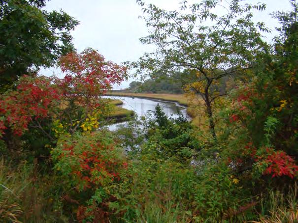
1 PROPERTY OFFERING Latimer Point Rd and Route 1 Two parcels, each in excess of 5 acres located on Stonington Rd and Latimer Point Rd. Come and explore the opportunities that may exist in close proximity to downtown Mystic and the New England Charm of Latimer Point.


2 *MAIN MENU Welcome to Stonington, CT The Town of Stonington shares a rich history with its 18,000 plus residents, vacationers and tourists each year. Within the 42.7 square miles you will find a modern day blend of history, technology, and recreation. Stonington includes a unique sophisticated appeal within a small New England town and is conveniently situated between New York City and Boston. Scenic backdrops of sunlit, coastal waters, with plentiful wildlife create a unique tranquility that can only be experienced. Stonington is an extraordinary town that thrives on innovative industry, preservation of scenic beauty and fully embraces its historical heritage. The Town of Stonington is situated in the southeastern corner of Connecticut, bordering Westerly, Rhode Island to the east, Long Island Sound to the south, Groton, Ledyard, and North Stonington to the west and north. Stonington is the only Connecticut town facing the Atlantic Ocean. Fishers Island and Long Island, New York, can be seen to the southwest and Block Island, Rhode Island to the southeast. The rocky shoreline has many peninsulas, islands, coves, and marshes. Information deemed to be reliable but not guaranteed. Parties are required to verify all information independently as the Owner and Representatives have no liability as to the accuracy or completeness of the material. All images, verbiage, layout and marketing materials herein are protected by copyright law.


3 Latimer Pt & Rt 1 ~ Land & Location Map Information deemed to be reliable but not guaranteed. Parties are required to verify all information independently as the Owner and Representatives have no liability as to the accuracy or completeness of the material. All images, verbiage, layout and marketing materials herein are protected by copyright law.

4 Latimer Pt & Rt 1 Parcel 3-4 ~ Parcel Map Information deemed to be reliable but not guaranteed. Parties are required to verify all information independently as the Owner and Representatives have no liability as to the accuracy or completeness of the material. All images, verbiage, layout and marketing materials herein are protected by copyright law.

5 Latimer Pt & Rt 1 Parcel 1a ~ Parcel Map Information deemed to be reliable but not guaranteed. Parties are required to verify all information independently as the Owner and Representatives have no liability as to the accuracy or completeness of the material. All images, verbiage, layout and marketing materials herein are protected by copyright law.

6 Elevation Lines Information deemed to be reliable but not guaranteed. Parties are required to verify all information independently as the Owner and Representatives have no liability as to the accuracy or completeness of the material. All images, verbiage, layout and marketing materials herein protected by copyright law.
7 Traffic Counts Information deemed to be reliable but not guaranteed. Parties are required to verify all information independently as the Owner and Representatives have no liability as to the accuracy or completeness of the material. All images, verbiage, layout and marketing materials herein protected by copyright law.

8
9 Stonington Zoning Regulations Amended through October 1, 2013 A R T I C L E I I I DISTRICT REGULATIONS RESIDENTIAL ZONES FOR RESIDENTIAL BULK REQUIREMENTS SEE TABLE RESIDENTIAL GBR-130, RC-120 ZONES [ADOPTED AUGUST 9, 1979] Purpose: GBR-130. This zone is located on fragile aquifer, watershed, streambelt, inland wetland and significant adjoining areas so as to preserve them for the future and present needs. RC-120. This zone encompasses coastal areas including coves, estuaries, tidal marshes and wetlands. It is established to preserve the natural habitat and assure flood protection Permitted Uses Residence: Single Family Aquaculture/Agriculture (a 200-foot setback for manure storage and stables is required from all property lines and tidal wetlands). [AMENDED AUGUST 3, 2004] Family day care homes. [ADOPTED SEPTEMBER 20, 1986] Keeping and breeding of livestock and to include commercial stables on 240,000 square feet or more (200-foot setback for stables and manure storage) Accessory Uses Agricultural or homemaking educational/training projects Barns, silos, greenhouses, outbuildings, and solar and energy conservation equipment Buildings or stands for display and sale of produce primarily grown on premises Accessory Apartments in accordance with Section 7.1. [ADOPTED JULY 30, 1991; AMENDED JULY 20, 2010] III-1
10 Stonington Zoning Regulations Amended through October 1, Garages and tool sheds. [ADOPTED JANUARY 9, 1985] Home Occupations, in accordance with Section Keeping of domestic animals. NOTE: No commercial activity involving domestic animals is permitted and no more than two (2) adults of a species per household number may be kept and only on the following lot sizes:.1 Dogs, cats, fowl, or others compatible with cohabitation with humans may be kept on the minimum lot areas..2 Grazing animals such as horses, cows, sheep, and goats with no more than two (2) animals per 130,000 square feet Recreational uses and structures such as, but not limited to, swimming pools and tennis courts Servant or guest accommodations (providing that the lot contains a minimum of 240,000 square feet) Parking of special vehicles..1 No more than one (1) commercial vehicle which shall be rated for not more than three-quarter (¾) ton..2 No recreational vehicle shall be used for living, sleeping or housekeeping, and shall not be parked in the side yard setbacks. [ADOPTED JULY 30, 1991] Parking, off street less than 20 cars (only as an accessory use to a permitted use on the same property), in accordance with Section [ADOPTED JUNE 1, 2004] Uses Allowed by Special Permit Boating facility (RC-120 Zone only) Cluster design, in accordance with provisions of Section [REPEALED AUGUST 21, 2006] Communication and water towers. [ADOPTED JULY 30, 1991] Conversion to three (3) or more residential units in accordance with provisions of Section [ADOPTED JULY 30, 1991] III-2
11 Stonington Zoning Regulations Amended through October 1, Kennels, in accordance with Section Lumbering and lumber mills Municipal facilities and activities Non-profit associations, clubs, museums, or art institutions, minimum lot requirement five (5) acres..1 Gift shops up to 1,000 square feet and snack bars up to 100 seats (available only for non-profit organizations) Processing, bottling, conversion of agricultural products primarily grown on premises Public/Private Recreational Facilities Public utility structures and facilities Recreational facilities incidental to municipal, church or school facilities Wineries Yachting facilities (RC-120 Zone only) Public or Private Elementary and Secondary Schools. [ADOPTED JUNE 15, 1999] Golf or Country Club Liquor Permit as defined by C.G.S. Sec a, as amended. [ADOPTED JULY 16, 2002] Bed and Breakfast Facilities in accordance with Section [ADOPTED SEPTEMBER 3, 1992] Parking, off street, 20 or more cars (only as an accessory use to a permitted use on the same property), in accordance with Section [ADOPTED JUNE 1, 2004] Parking, shared, in accordance with Section [ADOPTED JUNE 1, 2004; AMENDED DECEMBER 22, 2008] Filling, in accordance with Section [ADOPTED AUGUST 2, 2005] III-3
12 Stonington Zoning Regulations Amended through October 1, Rehabilitation of Existing Buildings, in accordance with Section [ADOPTED AUGUST 2, 2005] Height Exceptions for Roof Structures and Architectural Features, in accordance with Section [ADOPTED OCTOBER 18, 2005] Open Space Development, in accordance with Section [ADOPTED AUGUST 21, 2006] Buffer Requirements GBR-130. Wetlands, streams, ponds and other significant natural resources shall be separated from all uses by a minimum 100-foot non-infringement area RC-120. Non-infringement area of 100 feet minimum from tidal marsh and significant natural resources such as, but not limited to, inland wetlands, estuary shoreline and bodies of water, excepting only boat and yacht facilities after necessary State, Federal, and local permits are acquired. III-4
13 USE Stonington Zoning Regulations Amended through October 1, Residential Zones: Permitted, Accessory & Special Uses. [CREATED JULY 30, 1991] GBR 130 ZONE RC 120 RR 80 RA 40 RM 20 RM 15 RH 10 RA 20 RA 15 Accessory Apartments [ZR 7.1] A A A A A A A A A Agriculture/ Homemaking Educational Projects A A A A A A A A A Attached Housing [ZR ] N N N N S S S N N Aquaculture/Agriculture P P P N N N N N N Barns/Silos/Greenhouses/Out- Buildings/Solar and Energy Conservation Equipment Bed and Breakfast Facilities [ZR ] A A A A A A A A A S S S S S S S N N Boating Facility N S S S S S S S S Building or stands for Display-Sale of Produce grown on premise A A A A A A A A A Conversion 3 Units [ZR 6.6.4] S S S S S S S S S Cemeteries/Crematoriums Funeral Homes Change of Non-Conforming Use [ZR ] N N S S S S S N N S S S S S S S S S Churches/Places of Worship N N S S S S S S S Community Center/Library N N S S S S S N N Congregate Living Facility [ZR 6.6.2] N N S S S S S N N Convalescent Home [ZR 6.6.3] N N S S S S S N N Day Care Centers [ZR 1.2.2] N N S S S S S N N Duplex-Housing, Residential N N P P P P P N N Family Day Care Homes [1.2.2] P P P P P P P P P Excavation [ZR 6.6.7] N N S S N N N N N Filling [ZR 6.6.7] S S S S S S S S S Garages & Tool Sheds A A A A A A A A A Height Exceptions [ZR ] S S S S S S S S S Home Occupations [ZR 1.2.2] A A A A A A A A A V-2
14 Stonington Zoning Regulations Amended through October 1, 2013 USE GBR 130 ZONE RC 120 RR 80 RA 40 RM 20 RM 15 RH 10 RA 20 RA 15 Hospitals N N S S S S S N N Housing for the Elderly [ZR 6.6.6] N N N N S S S N N Keeping Domestic Animals A A A A A A A A A Keeping & Breeding Livestock P P P N N N N N N Kennels [ZR 6.6.8] S S S N N N N N N Lumbering/Lumber Mills S S S S N N N N N Municipal Facilities or Activities S S S S S S S S S Non-Profit Associations/ Clubs/Museums/Art Institutions Open Space Development 1 [ZR ] S S S S N N N N N P/S P/S P/S P/S P/S P/S P/S P/S N Parking, off-street 20 cars 2 A A A A A A A A A Parking, off-street 20 cars 2 [ZR ] S S S S S S S S S Parking, shared [ZR ] S S S S S S S S S Parking, Special Vehicles (RV's & Commercial) Processing/Bottling of Agriculture/Aquaculture Products Grown on Premise Public or Private Elementary & Secondary Schools A A A A A A A A A S S S S N N N N N S S S S S S S S S Public/Private Recreational Facilities N N S S S S S N N Public Utility Substation N N P P N N N N N Public Utility Structure & Facilities S S S S S S S S S Rehabilitation of Existing Buildings [ZR ] S S S S S S S S S Residence: Single-Family P P P P P P P P P Servant/Guest Accommodations A A A A A A A N N Recreation incidental to Municipal/Church/School Recreational Uses and Structures incidental to residential Use S S S S S S S S S A A A A A A A A A V-3
15 Stonington Zoning Regulations Amended through October 1, 2013 USE Schools Public/Private, Day Care Centers GBR 130 ZONE RC 120 RR 80 RA 40 RM 20 RM 15 RH 10 RA 20 RA 15 N N S S S S S N N Trailer Parks / Camps N N S S N N N N N Wellness Center N N S S S S S N N Water Towers [ZR 7.17] S S S S S S S S S Wineries S N S S N N N N N Yachting/Yacht Club & Facilities [ZR 6.6.9] N S S S S S S N N A = Accessory Use; S = Special Use Permit; P = Permitted Use; N = Not Permitted NOTES FROM ABOVE: 1. Open Space Developments are a permitted use, subject to subdivision review if comprised of singlefamily dwellings located on individual building lots. A Special Use Permit shall be required only if the land remains under single common ownership (Section ). 2. Off-street parking only as an Accessory Use to a Permitted Use on the same property. V-4


16
17
18
19

20
21
22
23
Schedule A Page 1 of 8
 PART A RESIDENTIAL AND RELATED USES A-1. A single detached dwelling for one (1) family and not more than one (1) such dwelling. A-2. Multiple dwellings consisting of two (2) or more dwelling units. (apartments)
FOR SALE. 63rd Street. Approx. 4.5 miles north of Route 60 on US Highway 1 in Vero Beach Acres and /- Acres - Totaling 13.
 FOR SALE MULTI-FAMILY RESIDENTIAL LAND US Highway 1 Frontage, Vero Beach, FL 32967 63rd Street 61st Street LOCATION: Approx. 4.5 miles north of Route 60 on US Highway 1 in Vero Beach. PARCEL ID#: 32-39-10-00000-7000-00027.0
ZONING. 27 Attachment 1. Township of East Rockhill. Table of Use Regulations
 ZONING 27 Attachment 1 Township of East Rockhill Table of Use Regulations AP Agriculture Preservation RP Resource Protection RR Rural Residential S Suburban R-1 Residential VR Village Residential VC Village
Asking $399,000. Great Sandwich Village Location Now Available! 161 Route 6A, Sandwich, MA. Brad Kuhrtz & Chris Bailey
 Great Sandwich Village Location Now Available! 161 Route 6A, Sandwich, MA Reasonably priced, and lots of space. 2,700 square foot building,.86 acre lot. Village Business zoning ( VIL in zoning use table)
SECTION 20 FUTURE DEVELOPMENT (FD) ZONE
 ZONE") SECTION 20 FUTURE DEVELOPMENT (FD) ZONE No person shall within a Future Development (FD) Zone use any land or erect, alter or use any building or structure except in accordance with the following provisions:
SECTION 20 FUTURE DEVELOPMENT (FD) ZONE No person shall within a Future Development (FD) Zone use any land or erect, alter or use any building or structure except in accordance with the following provisions:
Chapter 8 Development Management & Zoning Objectives
 Chapter 8 Development Management & Zoning Objectives 8.0 Introduction The Council, using its statutory powers granted under the Planning and Development Act 2000 (as amended) guides new development by
ZONING DISTRICT PERMITTED USES. Livestock farms, excluding raising swine Y Y Y S N N Y N S Y S N Y S N
 R60 R40 R30 R0 R0 RM GB LB OB LI LI OP OS P MT AGRICULTURAL Field crop farms or horticultural nurseries, including wholesale sales on the same lot Y Y Y Y N N Y Y Y Y Y N Y Y N Livestock farms, excluding
a) Ensure public safety through reducing the threats to life and personal injury.
 Ensure public safety through reducing the threats to life and personal injury.") SECTION VII: FLOODPLAIN DISTRICT 7-1 Statement Of Purpose The purposes of the Floodplain District are to: a) Ensure public safety through reducing the threats to life and personal injury. b) Eliminate
SECTION VII: FLOODPLAIN DISTRICT 7-1 Statement Of Purpose The purposes of the Floodplain District are to: a) Ensure public safety through reducing the threats to life and personal injury. b) Eliminate
Harnett County Unified Development Ordinance Use Table (Adopted October 17, 2011) Amended March 21, 2016
 Amended March 21, 2016") Harnett County Unified Development Ordinance Use Table (Adopted October 17, 2011) Amended March 21, 2016 Article V Use Regulations as shown 1.2 Table of Use Types & Regulations IND RA-0 RESIDENTIAL USES
Harnett County Unified Development Ordinance Use Table (Adopted October 17, 2011) Amended March 21, 2016 Article V Use Regulations as shown 1.2 Table of Use Types & Regulations IND RA-0 RESIDENTIAL USES
3,052+/- Sq Ft Office-Retail Building For Sale or Lease 261 Main Street, Wareham, MA
 3,052+/- Sq Ft Office-Retail Building For Sale or Lease 261 Main Street, Wareham, MA Main Street / Central Business District location (water front) Currently configured as a bank, with existing drive-thru
Executive Summary Offered at $9.2M
 Executive Summary Offered at $9.2M ROYAL COMMERCIAL CORP 611 Market Street Suite 8 Kirkland WA 98033 425-952-4000 www.royalcommercialcorp.com Table of Contents 1. Executive Summary The Offering Investment
Chapter PERMITTED USES
 Sections: 19.60.010 General. 19.60.020 Use categories. 19.60.030 Uses not listed. 19.60.040 Explanation of table abbreviations. 19.60.050 Permitted uses matrix. 19.60.010 General. Chapter 19.60 PERMITTED
R Rural District Excerpt from Caroline County, Maryland Zoning Ordinance
 R Rural District Excerpt from Caroline County, Maryland Zoning Ordinance This primary zoning district is intended to protect and preserve areas of the county, which are presently rural or agricultural
ORDINANCE NO NOW, THEREFORE, BE IT ENACTED BY THE CITY COUNCIL OF THE CITY OF OVIEDO, FLORIDA, AS FOLLOWS
 ORDINANCE NO. 1655 AN ORDINANCE OF THE CITY OF OVIEDO, FLORIDA AMENDING THE LAND DEVELOPMENT CODE OF THE CITY OF OVIEDO, SPECIFICALLY LAND DEVELOPMENT CODE ARTICLE IV ZONING DISTRICTS AND REGULATIONS,
A. The confined feeding of animals for foods, fur, or pleasure purposes on lots, pens, ponds, sheds, or buildings where:
 216 CONFINED FEEDING / INTENSIVE LIVESTOCK Definitions and Regulations Article 2 Sections 216.2(2) & 216.3(2) amended 11/24/2014 Ordinance # 2014-07 216 CONFINED FEEDING / INTENSIVE LIVESTOCK DEFINITIONS
Gordon County Permit Fees Effective August 1, 2012
 Gordon County Permit Fees Effective August 1, 2012 Residential Building Single Family Permit Fees (Refer to Building Valuation Data sheet to determine cost) $1,000.00 and less No fee unless inspection
Article 23-6 FLOODPLAIN DISTRICT
 AMENDING THE CODE OF THE CITY OF PITTSFIELD CHAPTER 23, ZONING ORDINANCE SECTION I That the Code of the City of Pittsfield, Chapter 23, Article 23-6 Floodplain District, shall be replaced with the following:
SLC COMMERCIAL 2488 SE Willoughby Blvd, Stuart, FL
 32.96 +/- Acres Vacant Land - US Hwy 1 Frontage Property Description: Located just north of the new 850 unit residential Grand Harbor development, this property is beautifully treed with majestic oaks
ORDINANCE NO
 ORDINANCE NO. 0-04-09 AN ORDINANCE AMENDING THE CODE OF ORDINANCES, CITY OF CROCKETT, TEXAS, BY THE AMENDMENT OF APPENDIX A, ZONING; AMENDING SECTIONS 201. 1, 201.2, 201.3, 201.4, 201.5, 201.6, 201.7,
THE CITY OF GROTON PLANNING AND ZONING COMMISSION MEETING MINUTES MAY 16, 2006
 THE CITY OF GROTON PLANNING AND ZONING COMMISSION MEETING MINUTES MAY 16, 2006 MUNICIPAL BUILDING COUNCIL CHAMBERS 7:30 PM I. ROLLCALL 7:35 PM Present: Michael Collins, David Rose, Irma Streeter, Debra
AN ORDINANCE. SECTION 1. Title 14 of The Philadelphia Code is hereby amended to read as follows: TITLE 14. ZONING AND PLANNING * * *
 AN ORDINANCE Amending Title 14 of The Philadelphia Code, entitled Zoning and Planning, by creating a new commercial mixed use district, providing for permitted uses and dimensional standards in that district,
For Sale/Lease 800 NEW HOLLAND AVENUE LANCASTER, PA Ruth M. Devenney, CCIM, SIOR
 For Sale/Lease 717.293.4477 800 NEW HOLLAND AVENUE LANCASTER, PA 17602 Ruth M. Devenney, CCIM, SIOR 717.293.4552 rdevenney@high.net 1853 William Penn Way Lancaster, PA 17601 717.293.4477 www.highassociates.com
LEE COUNTY, FLORIDA DEPARTMENT OF COMMUNITY DEVELOPMENT ZONING DIVISION STAFF REPORT
 LEE COUNTY, FLORIDA DEPARTMENT OF COMMUNITY DEVELOPMENT ZONING DIVISION STAFF REPORT TYPE OF CASE: Variance CASE NUMBER: VAR2010-00010 HEARING EXAMINER DATE: July 14, 2010 I. APPLICATION SUMMARY: A. Applicant:
BUTTE COUNTY ZONING ORDINANCE CONTENTS
 BUTTE COUNTY ZONING ORDINANCE CONTENTS Part 1 Enactment and Applicability Article 1. Purpose and Effect of the Zoning Ordinance... 3 24-1 Title... 3 24-2 Purpose of the Zoning Ordinance... 3 24-3 Relationship
Table : Allowed Uses in Neighborhood Residential Zones
 CITY OF LOGAN LAND DEVELOPMENT CODE September 17, 2013 Page 13-3 17.13.040 Neighborhood Residential s 17.13: Neighborhood Residential Zone Uses The following regulations are intended to accommodate a variety
FOR SALE. For More Information:
 FOR SALE 67th Street 3415 67th Place, Vero Beach, FL 32967 PARCEL ID #: 32391000000100000009.1 LOCATION: Great location on the corner of US 1 and Quay Dock Rd with approximately 54 feet of US 1 frontage.
Located at the corner of Weddington Road and Pitts School Road Concord
 6.71 ACRES RETAIL/OFFICE LAND FOR SALE Located at the corner of Weddington Road and Pitts School Road Concord BANK OWNED Property Highlights 6.71 Acres Zoned C 2, Conditional Water and sewage are nearby
RETAIL PROPERTY FOR SALE
 RETAIL PROPERTY FOR SALE AUTOMOTIVE OR REDEVELOPMENT OPPORTUNITY 3146 W. ALAMEDA AVE, DENVER, CO 80219 Presented By: JAY M. SONEFF. MBA PRESIDENT 303.295.1815 JAY@JAMISCO.COM Jamis Companies, Inc. 303.295.1815
USE GROUP Zoning Districts Use Standard Parking Standard Use Category B1 B2 B3 C1 C2 C3
 17-3-0207 Chicago Municipal Code Chicago Zoning Ordinance 17-3-0207 Use Table and s. USE GROUP Zoning Districts Use Parking RESIDENTIAL A. Household Living 1. Artist Live/Work Space located above the ground
CITY OF BRAMPTON COMPREHENSIVE ZONING BY-LAW REVIEW. Technical Paper #3 Minor Variances
 CITY OF BRAMPTON COMPREHENSIVE ZONING BY-LAW REVIEW Technical Paper #3 Minor Variances DRAFT MAY 2018 Table of Contents City of Brampton Comprehensive Zoning By-law Review 1 Introduction... 1 1.1 Background...
Underwriting Guidelines:
 AN INSURED MUST BE SAFETY CONSCIOUS AND HAVE A GOOD ATTITUDE TOWARDS LOSS PREVENTION. Underwriting Guidelines: 1. A policy may be issued for 1-4 unit owner-occupied structure, including Townhouses and
Malvern Borough Zoning Ordinance TABLE OF CONTENTS
 TABLE OF CONTENTS Article I: Title, Purpose, Objectives, and Interpretation Page Section 100. Title...I-1 Section 101. Purposes...I-1 Section 102. Statement of Community Development Objectives...I-1 Section
2 Institutional and Governmental Services. 3 Cultural, Entertainment and Recreation Services
 ARTICLE 3. - USE REGULATIONS Sec. 300. - Schedule of use regulations. The uses in the following schedule (referred to as the Schedule of Use Regulations Table and also the "Use Table") are permitted only
CITY OF SOLVANG FEES, CHARGES, AND FINES
 CITY OF SOLVANG FEES, CHARGES, AND FINES Planning and Community Development s: Alcoholic Beverage Control (ABC) License: New $ 264 Alcoholic Beverage Control (ABC) License: Transfer $ 110 Annexations $
TOWN OF KENT, CT PLANNING AND ZONING COMMISSION
 TOWN OF KENT, CT PLANNING AND ZONING COMMISSION FLOOD PLAIN MANAGEMENT REGULATIONS Whereas, Congress has determined that a National Flood Insurance Program would alleviate personal hardships and economic
WAYNE COUNTY PLANNING BOARD MINUTES February 29, 2012
 WAYNE COUNTY PLANNING BOARD MINUTES February 29, 2012 Steve Buisch called the February meeting of the Wayne County Planning Board to order at 7:00 p.m. in the Court House in Lyons, New York. Present: Staff:
Table SC-1 PERMITTED AND SPECIAL EXCEPTION USES SOUTH CAPE DOWNTOWN DISTRICT. P - Permitted SE - Special Exception - - Not Permitted
 1. Animal kennel (indoors only) P P P P 2. Artisan brewery - P(n) P(n) P(n) 3. Artisan distillery - P(n) P(n) P(n) 4. Artisan winery - P(n) P(n) P(n) 5. Assisted living facility - - P P 6. Automotive and
PROPERTY OFFERING. 32 Audette Rd, Franklin CT 06254
 PROPERTY OFFERING 32 Audette Rd, Franklin CT 06254 32 Audette Rd ~ Land & Location Map Information deemed to be reliable but not guaranteed. Parties are required to verify all information independently
Rural Based Business License Application
 New Applications All forms must be filled out completely, including mailing and business addresses and all available phone/fax/email information. Currently we do not accept applications by mail. $35.00
REPORT TO THE CHIEF ADMINISTRATIVE OFFICER FROM THE CORPORATE SERVICES DEPARTMENT REVIEW OF ASSESSMENT CLASS TAX RATES
 CITY OF KAMLOOPS Council Budget Meeting Agenda April 17, 2018, at 10:30 am in Council Chambers at 7 Victoria Street West, Kamloops, BC Page PRESENTATION 1. 2018-2022 BUDGET Budget PowerPoint Presentation
ORDINANCE NO
 ORDINAE NO. 12 094 Introduced by: Mr. Reda, Mr. Tackett Date of introduction: September 4, 2012 TO REVISE CHAPTER 40 OF THE NEW CASTLE COUNTY CODE (ALSO KNOWN AS THE UNIFIED DEVELOPMENT CODE OR UDC ) REGARDING
The Commonwealth of Massachusetts. Town of Northborough. Board of Health. Horse and Stable Regulations
 The Commonwealth of Massachusetts Town of Northborough Board of Health Horse and Stable Regulations A) Authority The Board of Health, Town of Northborough, Massachusetts, acting under the authority of
NO. SPONSOR TITLE INTRO. HEARING ACTION FINAL Aye
 1-18 CE Current Epense Budget Board of Education makes supplementary appropriations from unanticipated revenues to the Local Education Fund for the current fiscal year Current Epense Budget (Epires 4/7/18)
INTRODUCTION INTRODUCTION 1
 INTRODUCTION The provides a blueprint for the future growth and development of the City in the coming decade. The Comprehensive Plan is long-range in scope and represents a comprehensive update of the
BOX ELDER COUNTY PLANNING COMMISSION MINUTES September 18, 2014
 BOX ELDER COUNTY PLANNING COMMISSION MINUTES September 18, 2014 The Board of Planning Commissioners of Box Elder County, Utah met in the Box Elder County Commission Chambers at 7:00 p.m. The following
Residential Permits R-2, R-3, R-4, and U Occupancies 2018 Building Permit Valuation/Fee Schedule
 Residential Permits R-2, R-3, R-4, and U Occupancies 2018 Building Permit Valuation/Fee Schedule The base valuation to determine permit fees for residential buildings and additions are based on a dollar
CHAPTER 15: FLOODPLAIN OVERLAY DISTRICT "FP"
 CHAPTER 15: FLOODPLAIN OVERLAY DISTRICT "FP" SECTION 15.1 STATUTORY AUTHORIZATION The legislature of the State of Minnesota in Minnesota Statutes, Chapter 103F and Chapter 394 has delegated the responsibility
Simsbury. Challenges Capitol Region Natural Hazards Mitigation Plan Update - Page 356
 Simsbury Simsbury is a suburban community of about 23,600 located in the western portion of the Capitol Region. Its land area encompasses 33.9 square miles. Elevation in town generally ranges from about
Board of Variance Minutes
 Board of Variance Minutes Council Chamber City Hall 14245-56 Avenue Surrey, B.C. WEDNESDAY, NOVEMBER 24, 2010 Time: 9:01 a.m. File: 0360-20 Present: Chairperson - M. Cooper A. Pease D. Kenny K. Nice Absent:
Western SoMa Land Use Matrix (Proposed by the WSoMa Task Force on 7/15/2010)
") RESIDENTIAL Residential Use 890.88 790.88 Dwelling Units P P P P (1) P P P (2) P P Group Housing C P C (1) C C C (2) C C SRO Units P (3) P (3) P (3) P (3) P (3) Student Housing 315.1(38) C (4) C (4) C
RESIDENTIAL Residential Use 890.88 790.88 Dwelling Units P P P P (1) P P P (2) P P Group Housing C P C (1) C C C (2) C C SRO Units P (3) P (3) P (3) P (3) P (3) Student Housing 315.1(38) C (4) C (4) C
MOONEE RELEASE AREA Development Contributions Plan 2015
 MOONEE RELEASE AREA Development Contributions Plan 2015 TABLE OF CONTENTS PART A PLAN SUMMARY...1 1. NAME AND LEGAL BASIS OF THE PLAN... 1 2. THE AREA TO WHICH THE PLAN APPLIES... 1 3. PURPOSES OF THE
PLANNING AND ZONING COMMISSION COMMUNICATION
 PLANNING AND ZONING COMMISSION COMMUNICATION City of Longmont, Colorado Project Title: Meeting Date: April 25, 2018 Land Development Code and Official Zoning Map Update Staff Planner: Brien Schumacher,
CITY OF KAMLOOPS Council Budget Meeting Agenda March 14, 2017, at 9:00 am in Council Chambers at 7 Victoria Street West, Kamloops, BC, V2C 1A2
 CITY OF KAMLOOPS Council Budget Meeting Agenda March 14, 2017, at 9:00 am in Council Chambers at 7 Victoria Street West, Kamloops, BC, V2C 1A2 1. REPORTS Chief Administrative Officer 1.1 Review of Assessment
TOWN OF CHINO VALLEY CONSOLIDATED FEE SCHEDULE
 TOWN OF CHINO VALLEY CONSOLIDATED FEE SCHEDULE TABLE OF CONTENTS PAGE NO. Animal Control 2 Aquatic Center 3 Building Permit Inspection 4 Building Permit Fees 5 Building Plan Review 6 Business Licenses
TABLE OF CONTENTS CHAPTER 80: AREA ZONING CODE
 TABLE OF CONTENTS CHAPTER 80: AREA ZONING CODE RIPLEY COUNTY, INDIANA SECTION PREAMBLE 1 80.01: SHORT TITLE 3 80.02: ESTABLISHMENT OF DISTRICTS AND ZONE MAP 3 (A) District s and Designations 3 (B) Zone
Comhairle Chontae na Gaillimhe Galway County Council
 Comhairle Chontae na Gaillimhe Galway County Council Development Contribution Scheme 2010 under Section 48, Planning & Development Act, 2000. (As Amended). This Scheme was adopted by the members on the
Planning Commission Agenda
 I. CALL TO ORDER II. ROLL CALL Planning Commission Agenda October 24, 2017 6:00 PM, Council Chambers, Independence City Hall City Code Chapter 14 and the staff reports are entered into the record. III.
The foundation of the Elk Grove General Plan is the Vision Statement, contained in the Preface to this General Plan
 General Plan Goals The Goals, Policies, Action Items/ Implementation steps in this General Plan are organized as shown below. Each of the items in descending order provides more detail specific information
Farm & Ranch Application
 Farm & Ranch Application PO Box 4479, Houston Texas 77210 or 3131 Eastside #600, Houston Texas 77098 P. 713.351.8348 800:235:3817 F. 713.351.8492 800.294.0851 ncy Information Code: Address: Name: City:
FLOODPLAIN DEVELOPMENT VARIANCE APPLICATION PACKET
 FLOODPLAIN DEVELOPMENT VARIANCE APPLICATION PACKET Sutter County Water Resources Department 1130 Civic Center Boulevard Yuba City, California, 95993 (530) 822-7400 Floodplain management regulations cannot
Resolution # City of Fernley BUSINESS LICENSE FEE SCHEDULE Exhibit A Effective May 4, 2017
 Resolution # 17-004 City of Fernley BUSINESS LICENSE FEE SCHEDULE Exhibit A Effective May 4, 2017 Pursuant to Fernley Municipal Code, any business, commercial enterprise, trade, occupation, calling, profession,
City of Monte Sereno
 MASTER FEE SCHEDULE Services / Activities / Subject Matter Effective Date Page Planning s July 1, 2018 1-2 Public Works s July 1, 2018 3-4 Building s July 1, 2018 5-6 Administrative Services July 1, 2018
QUASI-JUDICIAL ZONING APPEALS SPECIAL MASTER HEARING MINUTES CITY OF DEERFIELD BEACH, FLORIDA July 12, 2011 CALL TO ORDER
 QUASI-JUDICIAL ZONING APPEALS SPECIAL MASTER HEARING MINUTES CITY OF DEERFIELD BEACH, FLORIDA July 12, 2011 CALL TO ORDER Special Master Jeffrey Siniawsky called the hearing to order at 2:00 p.m. in the
SURFSIDE INVESTMENT PORTFOLIO
 SURFSIDE INVESTMENT PORTFOLIO MARCH 2015 FINANCIAL OVERVIEW + ANALYSIS MIAMI BEACH, FLORIDA The information contained herein was furnished to us by sources, which we deem reliable, but no warranty or representation
F Use Table and Standards.
 17-6-0403-F Use Table and Standards. USE GROUP 1 2 4 7 8 11 PUBLIC AND CIVIC A. Day Care - P - - - P P P P P P - P - - - P P P P P 17--0105.5 B. Detention and Correctional Facilities C. Parks and Recreation
20 1/2 BERRY ROAD DERRY, NH
 FO R SAL E BERRY ROAD DERRY, NH 100+/- ACRE LAND SITE DEVELOPMENT OPPORTUNITY The Stubblebine Company is pleased to offer for sale Berry Rd, Derry, NH to the marketplace: Two parcels of land comprising
BOX ELDER COUNTY PLANNING COMMISSION MINUTES JUNE 17, 2010
 BOX ELDER COUNTY PLANNING COMMISSION MINUTES JUNE 17, 2010 The Board of Planning Commissioners of Box Elder County, Utah met in the Box Elder County Commission Chambers at 7:00 p.m. The following members
FOR SALE CLICK HERE TO TOUR HARBOR NORTH DEVELOPMENT OPPORTUNITY ON A HIGHLY DESIRABLE, WELL EQUIPPED, FULL-SERVICE MARINA WITH 90 BOAT SLIPS
 400 HURON STREET HURON, OHIO 44839 CLICK HERE TO TOUR HARBOR NORTH WWW.CBREHARBORNORTH.COM OFFERING OVERVIEW Income producing and development opportunity, which includes a 1,500 SF marina store with offices
THE FLOOD HAZARD AREA Valda Opara New Jersey Department of Environmental Protection June 8, 2012
 THE FLOOD HAZARD AREA Valda Opara New Jersey Department of Environmental Protection June 8, 2012 Individual Permits Building Requirements 0% Net-fill Standards JET SKIING DURING A FLOOD ESCAPING THE FLOOD
SECTION 20.0 Page 20-1 TRANSITIONAL INDUSTRIAL ZONE (M4)
") SECTION 20.0 Page 20-1 20.1 USES PERMITTED No person shall within any M4 Zone use any lot, or erect, alter or use any building or structure for any purpose except one or more of the following M4 uses;
SECTION 20.0 Page 20-1 20.1 USES PERMITTED No person shall within any M4 Zone use any lot, or erect, alter or use any building or structure for any purpose except one or more of the following M4 uses;
Chapter 113 FLOODPLAIN MANAGEMENT ARTICLE I. IN GENERAL
 Chapter 113 FLOODPLAIN MANAGEMENT Sec. 113-1. Findings of Fact and Purpose. ARTICLE I. IN GENERAL Statutory Authorization: The legislature of the State of Minnesota has, in Minnesota Statutes Chapter 103F
CHAPTER ONE. ORGANIZATION, FUNCTIONS AND GENERAL PROVISIONS. Subchapter 1.10: Master Fee Schedule
 CHAPTER ONE. ORGANIZATION, FUNCTIONS AND GENERAL PROVISIONS Subchapter 1.10: 1.10.000. Fees and Charges. The fees set forth in this shall be charged for the respective services described herein. The fees
3 COMMERCIAL PARCELS AVAILABLE ACRES (DIVISIBLE) HASTINGS CROSSROADS Hastings, MN 55033
 HASTINGS CROSSROADS Hastings, MN 55033") -$1,450,000 AVAILABLE (DIVISIBLE) LAKE ISABELLE RAVENNA TRAIL 15TH ST W GENERAL SIEBEN DR PLEASANT DR DAKOTA PINES GOLF CLUB 18TH ST E 160TH ST E VERMILLION RD PID: 191840000030 2.71 ACRES PID: 191840000020
-$1,450,000 AVAILABLE (DIVISIBLE) LAKE ISABELLE RAVENNA TRAIL 15TH ST W GENERAL SIEBEN DR PLEASANT DR DAKOTA PINES GOLF CLUB 18TH ST E 160TH ST E VERMILLION RD PID: 191840000030 2.71 ACRES PID: 191840000020
CITY OF PALM DESERT COMPREHENSIVE GENERAL PLAN
 Comprehensive General Plan/Administration and Implementation CITY OF PALM DESERT COMPREHENSIVE GENERAL PLAN CHAPTER II ADMINISTRATION AND IMPLEMENTATION This Chapter of the General Plan addresses the administration
Land use Zoning Objectives North Tipperary County Development Plan 2010 (as varied)
") Land use Zoning Objectives North Tipperary County Development Plan 2010 (as varied) The purpose of land-use zoning is to indicate the development management objectives of the Council for all zoned lands
Land use Zoning Objectives North Tipperary County Development Plan 2010 (as varied) The purpose of land-use zoning is to indicate the development management objectives of the Council for all zoned lands
LTABLE LAND USE TABLE
 AGRICULTURE Agricultural uses for fuel modification A A A 17.90.020 Crop Production C 17.12.030 Equestrian Facilities C C C C A Farm Animals A A A 17.12.040 Hobby Farms A A 17.12.030 Kennels and animal
Spring Hill Zoning & Subdivision
 Spring Hill Zoning & Subdivision AGENDA Introduction to Camiros Introduction to Zoning Overview of Project! Process! Current understandings! What we ve heard so far Public Comment Camiros Key Personnel
AN ORDINANCE THE COUNCIL OF THE CITY OF PHILADELPHIA HEREBY ORDAINS:
 AN ORDINANCE Amending Title 14 of The Philadelphia Code, entitled Zoning and Planning, by revising certain provisions relating to allowed uses and dimensional standards in commercial districts, and making
A X X X X X X. Airport or heliport X X S S S S S X S X S X X X X D S S X X X C X X X X X S S S S X X X X
 Accounting, auditing and bookkeeping services A X X X X X X Advertising agencies A X X X X X X Airport or heliport X X S S S S S X S X S X X X X Anhydrous ammonia or similar liquefied fertilizers, storage
Community Incentives for Nature-Based Flood Solutions
 Community Incentives for Nature-Based Flood Solutions A GUIDE TO FEMA S COMMUNITY RATING SYSTEM FOR CONSERVATION PRACTITIONERS The Federal Emergency Management Agency (FEMA) uses a Community Rating System
PROPERTY OFFERING 55 Otter Cove DR Old Saybrook CT 06475
 PROPERTY OFFERING 55 Otter Cove DR Old Saybrook CT 06475 Welcome to Old Saybrook, CT Welcome to Old Saybrook, Connecticut, where the Connecticut River Meets the Sound. We are one of the oldest towns in
PERMISSIVE TAX EXEMPTION POLICY
 PERMISSIVE TAX EXEMPTION POLICY BOWEN ISLAND MUNICIPALITY MISSION STATEMENT In carrying out its mandate, Bowen Island Municipality will work towards conducting operations in a way that: 1. Improves the
OFFICE OF HISTORIC RESOURCES City Hall 200 N. Spring Street, Room 559 Los Angeles, CA 90012
 City Hall 200 N. Spring Street, Room 559 Los Angeles, CA 90012 February 2, 2015 TO: Jose Huizar, Chair Planning and Land Use Management Committee FROM: Ken Bernstein, AICP Manager, Office of Historic Resources
Chairman and Members, North York Community Council. Director and Deputy Chief Building Official, Toronto Building, North York District
 STAFF REPORT ACTION REQUIRED Sign Variance Date: June 1, 2009 To: From: Wards: Reference Number: Chairman and Members, North York Community Council Director and Deputy Chief Building Official, Toronto
Town of Tyrone Planning Commission Meeting Minutes Thursday June 22, :00 PM
 Town of Tyrone Planning Commission Meeting Minutes Thursday June 22, 2017 7:00 PM Present: Chairman Wil James Vice-Chairman Jeff Duncan Commission Member Carl Schouw Commission Member David Nebergall Commission
PREFERRED RISK POLICY
 Previous Section Main Menu Table of Contents Next Section PREFERRED RISK POLICY I. GENERAL DESCRIPTION The Preferred Risk Policy (PRP) is a lower-cost Standard Fld Insurance Policy (SFIP), written under
Lound with Ashby, Herringfleet and Somerleyton NEIGHBOURHOOD PLAN QUESTIONNAIRE. It s time to have your say
 Lound with Ashby, Herringfleet and Somerleyton NEIGHBOURHOOD PLAN QUESTIONNAIRE It s time to have your say It s Here! NEIGHBOURHOOD PLAN QUESTIONNAIRE FOR Lound, Ashby, Herringfleet and Somerleyton The
Maryland Model Floodplain Management Ordinance (May, 2014) MODEL NOTES
 MODEL NOTES") Maryland Model Floodplain Management Ordinance (May, 2014) MODEL NOTES The model floodplain management ordinance that most Maryland communities have used as the basis for their regulations since the early
Maryland Model Floodplain Management Ordinance (May, 2014) MODEL NOTES The model floodplain management ordinance that most Maryland communities have used as the basis for their regulations since the early
Barrow County Occupational Tax / Regulatory Fee Registration Form
 Barrow County Occupational Tax / Regulatory Fee Registration Form Economic & Community Development 30 North Broad Street Winder, GA 30680 770-307-3021 www.barrowga.org Date: Name of Business: Location
Application for Home Based Business Tax Receipt
 Application for Home Based Business Tax Receipt Your Business Tax Receipt is issued subject to Palm Beach Gardens Code Section 78-159 (1): I hereby apply for a Home Based Business Tax Receipt to use a
General Plan Goals. Vision. More Detail. More Detail. More Detail. More Detail
 GOALS The, Policies, and Action Items/ Implementation steps in this General Plan are organized as shown below. Each of the items in descending order provides more detail and specific information about
Up Previous Next Main Search Print Title 9 LAND USE Chapter 9.18 MIXED USE REGULATIONS AND DEVELOPMENT STANDARDS Section 9.18.
 1 of 13 12/12/2018, 4:07 PM Garden Grove Municipal Code Up Previous Next Main Search Print Title 9 LAND USE Chapter 9.18 MIXED USE REGULATIONS AND DEVELOPMENT STANDARDS Section 9.18.020 Uses Permitted
TOWN OF PALMER BUILDING PERMIT APPLICATION FOR OTHER THAN ONE AND TWO FAMILY DWELLINGS (or their accessory structures)
") BP20 - P. 1 of 7 TOWN OF PALMER BUILDING PERMIT APPLICATION FOR OTHER THAN ONE AND TWO FAMILY DWELLINGS (or their accessory structures) Amount: Received: From: Ck.or Rcpt.# Ck Date: The applicant should
BP20 - P. 1 of 7 TOWN OF PALMER BUILDING PERMIT APPLICATION FOR OTHER THAN ONE AND TWO FAMILY DWELLINGS (or their accessory structures) Amount: Received: From: Ck.or Rcpt.# Ck Date: The applicant should
CITY OF FERNLEY RESOLUTION # A RESOLUTION OF THE CITY OF FERNLEY MODIFYING BUSINESS LICENSE FEE SCHEDULE
 CITY OF FERNLEY RESOLUTION # 17-017 A RESOLUTION OF THE CITY OF FERNLEY MODIFYING BUSINESS LICENSE FEE SCHEDULE WHEREAS, the City of Fernley, a political subdivision of the State of Nevada, organized pursuant
TEXT. John Oien First Vice President Lic
 TEXT 1 O N TA R I O G AT E WAY S W C C O R N E R O F O N TA R I O R A N C H R D. A N D H A M N E R AV E. O N TA R I O, C A On/off ramps H A M N E R AV E O N TA R IO R A N C H R D M I L L I K E N AV E Brian
BUILDING EXCISE TAX ORDINANCE
 BUILDING EXCISE TAX ORDINANCE FOR WASHINGTON COUNTY, MARYLAND Adopted June 17, 2003 Effective July 1, 2003 Revision 1 (Amended) - Adopted June 22, 2004 Effective as of July 1, 2004. Revision 2 - Adopted
WATERFRONT MIXED USE PENINSULA LAND FOR SALE W Gandy Blvd & West Shore Blvd Tampa, FL Acres (mol) Entitled $21,000,000 ($2.
 Entitled $21,000,000 ($2.") This property represents an opportunity to acquire the premier remaining parcels of the Westshore Marina District. Upon completion the district and adjacent parcels are anticipated to include 1,500 (mol)
This property represents an opportunity to acquire the premier remaining parcels of the Westshore Marina District. Upon completion the district and adjacent parcels are anticipated to include 1,500 (mol)
AGENDA OF THE COUNCIL OF THE CITY OF FORT COLLINS, COLORADO. October 19, Proclamations and Presentations 5:30 p.m.
 AGENDA OF THE COUNCIL OF THE CITY OF FORT COLLINS, COLORADO October 19, 2004 Proclamations and Presentations 5:30 p.m. A. Proclamation Proclaiming October 23, 2004 as Make a Difference Day. B. Proclamation
Updated Planning Commission Work Program ( )
") Updated Planning Commission Work Program (2017-2019) The Planning Commission Work Program contains projects and planning activities that are slated for completion in or substantial progress during the
Updated Planning Commission Work Program (2017-2019) The Planning Commission Work Program contains projects and planning activities that are slated for completion in or substantial progress during the
H 6099 S T A T E O F R H O D E I S L A N D
 LC000 0 -- H 0 S T A T E O F R H O D E I S L A N D IN GENERAL ASSEMBLY JANUARY SESSION, A.D. 0 A N A C T RELATING TO ALCOHOLIC BEVERAGES - RETAIL LICENSES IN THE CITY OF PROVIDENCE Introduced By: Representatives