South Carolina Guide to Beachfront Property. Insight for Informed Decisions
|
|
|
- Kathryn Hodge
- 5 years ago
- Views:
Transcription

1 South Carolina Guide to Beachfront Property Insight for Informed Decisions
2 Financial assistance provided under Cooperative Agreement NA12NOS by the Coastal Zone Management Act of 1972, as amended, administered by the Office of Ocean and Coastal Resource Management, National Oceanic and Atmospheric Administration
3 Table of Contents Introduction...1 Common Coastal Hazards...2 Long-Term Chronic Erosion... 2 Storm-Driven Erosion... 3 Flooding... 4 Avoid Purchasing Property Prone to Hazards... 4 Know State Laws... 5 Determine if Erosion is an Issue... 6 Ask a Licensed Real Estate Professional... 7 Research Resilience to Large Storms... 7 Seek Local Knowledge... 7 Investigate Insurance Options & Requirements... 8 Developing on Coastal Property...11 Building on an Undeveloped Beachfront Lot Construction Seaward of the Setback Line Construction Seaward of the Baseline Coastal Construction Features Waste Management Upgrading or Adding to Beachfront Homes Protecting & Repairing Coastal Property...15 Dunes and Dune Walkovers Relocation Safe Home Program Sandbags, Sand Scraping, and Minor Renourishment Erosion Control Structures Recovery After a Storm Repairing and Rebuilding Additional Information & Contacts...20 Contributing Organizations...21
4
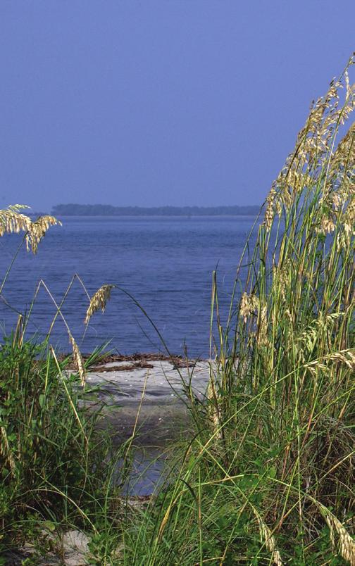
5 Introduction With nearly 200 miles of oceanfront shoreline, South Carolina is home to some of the most spectacular beaches in the world. The beautiful, dry sand beaches, rolling dunes, and wildlife attract vast numbers of tourists, new residents, and investors alike. However, before purchasing coastal property, potential buyers should consider a number of different factors. Like any other coastal location, South Carolina oceanfront and adjacent properties may be susceptible to an array of natural hazards. These hazards may affect property value, or potentially increase ownership costs, including insurance and hazard mitigation (e.g. renourishment, building dunes, moving the structure more landward, or increasing the elevation of the structure). Federal, state, or local legislation may also affect your decision to purchase coastal property. Buyers should be informed of the specific laws governing oceanfront properties and the types of activities allowed. This guide is designed to address questions that arise for individuals purchasing coastal property. It provides guidance on topics, such as what to consider before buying coastal property, how to renovate coastal property, and how to manage the property should it be damaged by a natural hazard. Whether considering an undeveloped lot or one with an existing structure, there are critical issues to examine. Introduction 1
6 Common Coastal Hazards The South Carolina coastline is dynamic and constantly changing due to a common coastal hazard beach erosion. Beach erosion can be a long-term, chronic condition caused by a variety of factors, or it may be short-term as the result of a single or series of storm events, like hurricanes, tropical storms, or nor easters. In addition to erosion, beachfront homes may also be threatened by high wind and flooding from storm-driven waves or tides. Long-Term Chronic Erosion The majority of South Carolina beaches undergo long-term chronic erosion, often called beach migration, due to coastal geological processes. Ocean currents, prevailing winds, proximity to inlets, locations of nearshore sandbars, and other natural or manmade features will affect the long-term rate of erosion along a beach. Chronic erosion can be exacerbated by gradually rising sea levels. Sea level in the Charleston area has risen nearly one foot during the last century, causing beaches to migrate landward. Long-term erosion poses a considerable risk to beachfront properties, yet it is often misunderstood. Many people associate erosion with short-term storm events and do not contemplate the effects of long-term chronic erosion. Erosion rates are measured by analyzing historical shoreline positions and calculating annual erosion rates based on beach profile and volumetric data. Erosion rates can be localized to a specific area. In fact, it is possible for one stretch of beach to show no signs of erosion, while an adjacent stretch of beach loses a large volume of sand annually. Beaches along inlets are often the most unstable and profoundly affected. Some migrating inlets are constantly moving in one direction. Others may expand and contract in 2 South Carolina Guide to Beachfront Property

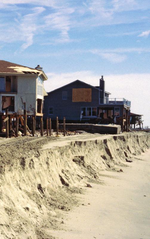
7 Erosion Accretion Erosion Accretion Figure 1. A groin (yellow circle) can trap sand on one side but increase erosion on the other, as seen in this example of Edisto Island (Google Map 2014). intervals. In addition to natural causes, chronic erosion can be set in motion by human activities. For example, a groin built to stabilize a portion of the beach can trap sand on one side but increase erosion on the other (Figure 1). Storm-Driven Erosion South Carolina s beaches are also vulnerable to rapid, stormdriven erosion. Hurricanes, or large storms like nor easters, generate strong waves and currents that can intensify erosion along the shoreline. These events, particularly when coupled with storm surge, can cause sudden and widespread changes to the shoreline and put property in imminent danger (Figure 2). Even if a storm does not make landfall, beaches may still be affected. Coastal storms also cause seasonal fluctuations of the shoreline. Generally, beaches erode more in the stormy fall and winter months than in the calm summer months. Of course, when a beach is hit directly by a hurricane, beachfront erosion can be extensive and severe. Inlets are also affected by seasonal storms and can change configuration rapidly as large volumes of water and sand flow through them. In severe storms, it is even possible for new inlets to form and existing inlets to close. Common Coastal Hazards 3

8 Flooding Flooding is the most common disaster in the United States, and can occur as a result of storm surge, heavy rain events, and/ or high tides. Coastal flooding is a common occurrence, as most coastal properties are in lowlying areas and are subject to inundation from saltwater. Not only can flooding threaten property, but it can also prevent access to certain areas, reduce mobility, and prevent safe evacuations due to damaged or impassible roadways. Long Term Erosion Rates: Long term erosion rates are determined by analyzing historical shoreline positions and calculating annual erosion rates based on beach survey data. Each year, DHEC monitors over 400 survey monuments on state beaches to conduct analysis, in conjunction with professional coastal engineers or shoreline researchers from leading academic institutions. AVOID PURCHASING PROPERTY PRONE TO HAZARDS Purchasers of coastal property should always research coastal hazards, seeking information on pertinent laws and regulations from local governments, the South Carolina Department of Health and Environmental Control, Office of Ocean and Coastal Resource Management (DHEC-OCRM), and a licensed real estate professional. Uninformed decisions can lead to unexpected costs to the property owner. Potential buyers take on risk from damage of a highly erosional beach, which may result in property damage and may require further actions to mitigate the hazard. Similarly, potential buyers take on risk by purchasing property in a flood zone, which may result in flood damage and expensive insurance costs if the home is not Figure 2. Erosion at Folly Beach caused by Tropical Storm Irene in 2011 and Alberto in 2012, both storms passed more than 100 miles offshore. Photo courtesy of DHEC. 4 South Carolina Guide to Beachfront Property
9 built to current building codes. The following section provides information to buyers considering beachfront property prone to hazards, as well as guidance for how to protect their investment. Know State Laws The South Carolina Beachfront Management Act (SC Code Ann et seq.) and associated regulations establish the state s jurisdictional authority within the beachfront critical areas. Within these areas, DHEC regulates new construction, repair, and reconstruction of buildings in addition to the maintenance of erosion control structures. However, new erosion control devices are strictly prohibited within the setback area. The purpose of these laws and regulations is to protect the quality of the coastal environment while affording reasonable use and development of property. State Beachfront Jurisdiction The state s beachfront jurisdictional lines are calculated by analyzing current and historical shoreline positions and long-term erosion rates. DHEC is mandated by the South Carolina Beachfront Management Act to review the position of the beachfront baseline and setback line every eight to ten years. Within standard erosion zones, the baseline is established at the location of the crest of the primary oceanfront sand dune. On armored beaches and areas without a primary sand dune, DHEC uses scientific methods to determine where the natural dune would be if natural or man-made occurrences had not interfered with nature s dune building process. For inlet areas that are not stabilized by jetties, terminal groins or other structures, the baseline is determined as the most landward point of erosion at anytime during the past 40 years. Within inlet areas that are stabilized, the baseline is determined by the location of the primary oceanfront sand dune. The setback line is established landward of the baseline at a distance of 40 times the beach s annual erosion rate. The erosion rate is calculated using the best available historical shoreline position and scientific monitoring data. For example, if the erosion rate is one foot per year, the resulting setback line will be positioned 40 feet landward of the baseline. Even if a beach is gaining sand through accretion or is otherwise not experiencing erosion, the setback line is always located a minimum distance of 20 feet landward of the baseline (Figure 3). Common Coastal Hazards 5

10 Setback Area Beach/Dune System Setback Line = 40x Erosion Rate Baseline = Primary Dune Crest Escarpment or Line of Vegetation Active Beach Mean HighWater Mean Low Water Figure 3. Cross-section of beach profile, including the State s jurisdictional baseline and setback line in a standard zone. Determine if Erosion is an Issue Erosion rates vary from one municipality to another, but may also vary significantly along a specific beach. Due to localized differences, it is imperative to gather information regarding specific erosion rates for the area in which the property is located. The adopted long-term erosion rates for a specific property can be found through the DHEC Beachfront Jurisdiction web application ( The website application is a convenient way to locate a parcel, identify the state s beachfront jurisdictional baselines and setback lines, and obtain an adopted erosion rate for the area of interest (Figure 4). Figure 4. South Carolina Beachfront Jurisdiction web application. Available at 6 South Carolina Guide to Beachfront Property

11 Ask a Licensed Real Estate Professional South Carolina law requires that a contract of sale or transfer of real property contain a disclosure statement if a property is affected by the state s beachfront jurisdictional authorities. Licensed real estate professionals have a fiduciary responsibility to disclose material facts, like the adopted erosion rates of beachfront properties ( ). Although agents might not always know the erosion rates for particular oceanfront properties, they should provide assistance in obtaining this information. passing offshore. For example, in 2011, Hurricane Irene passed about 120 miles offshore, causing extreme erosion in some locations. Consequently, Folly Beach County Park was forced to close for two years and did not reopen until the beach could be renourished. Research Resilience to Large Storms South Carolina has been fortunate to only experience minor hurricane impacts since Hurricane Hugo in Hugo made landfall slightly north of Charleston, at Sullivan s Island, as a Category 4 hurricane, with sustained winds of mph. It was the costliest storm in South Carolina history, causing over $7 billion in damages (National Weather Service; Figure 5). Even if a hurricane does not make a direct landfall, beachfront communities are frequently affected by erosion caused from storms Figure 5. During Hurricane Hugo in 1989, (top) a new inlet formed on Pawleys Island; and (bottom) the Ben Sawyer Bridge collapsed, near Charleston, South Carolina. Photos courtesy of NOAA. Seek Local Knowledge Ask local residents about their knowledge of the stability of the beach, renourishment projects that have been completed or planned, flooding from storms, etc. Their experiences and longterm knowledge can provide valuable insight into the area. Common Coastal Hazards 7
12 Moreover, archived news articles from the local papers can provide information about how the area fared after particular storm events. Investigate Insurance Options & Requirements Standard homeowner s insurance does not cover flood damage. Whether building a home or buying property, be sure to know the flood risk of the area. Depending on the risk associated with the property, it is wise, and may be mandatory, to purchase flood insurance. To better understand flood risks and potentially reduce flood insurance rates, locate flood insurance maps of the area of interest and obtain an elevation certificate to determine the required elevation of the structure. Flood Insurance Rate Maps FEMA produces flood insurance rate maps (FIRMs) that identify coastal flood risk areas using the latest data and technology. FIRMs delineate flood risk zones, Special Flood Hazard Areas (SFHAs; Figure 6), and identify Coastal Barrier Resources Act (COBRA) zones. SFHAs include Zone VE and Zone AE and have at least a 1% chance of flooding in any given year and a one-infour chance of flooding during a typical 30-year mortgage period. These areas take into account the risk from storm surge and winddriven waves and often require the owner to have flood insurance. Zone X is considered a low risk area for flooding. Purchasing flood insurance for Zone X is usually not required, but may provide property owners with additional protection. As a way to minimize loss of human life and limit damage to natural resources associate within undeveloped coastal areas, Congress enacted the Coastal Barrier Resources Act. The Act identifies particular coastal barrier resources system (CBRS) units and Otherwise Protected Areas (OPA), collectively called COBRA zones. Development within COBRA zones is permitted; however, federal financial assistance is not available in COBRA zones. Information on the flood risk and COBRA zones for a specific property can be found on the FEMA website ( If the property falls into a SFHA, an insurance agent should be contacted to discuss purchasing a flood insurance policy. 8 South Carolina Guide to Beachfront Property

13 Zone VE a high-risk area where storms drive waves landward at heights of 3 feet or more. Coastal Zone AE a high-risk area subject to wave heights of 1.5 to 3 feet. For flood insurance purposes, this zone is treated as Zone AE; however, communities are encouraged to regulate construction to include Zone VE standards as these waves can still cause significant damage to coastal structures. Zone AE a high-risk area subject to waves less than 1.5 feet in height. This will be separated from the Coastal AE zone by the Limit of Moderate Wave Action (LiMWA). A LiMWA may not always be present, in which case, only Zone AE is shown. Zone X areas of moderate risk (shown as a shaded zone X) or low risk (zone X). While the risk is reduced, nearly 25% of all flood claims come from these zones. Figure 6. Flood Risk Zones, courtesy of FEMA FloodSmart.gov Elevation Certificate The elevation of a structure compared to the estimated Base Flood Elevation (BFE), or the elevation to which floodwater is anticipated to rise, can have a major impact on the costs of flood insurance. The BFE of an area can be found in the FIRM. If a current elevation certificate is not available for the property, a state-licensed surveyor will need to complete one. To learn more about elevation certificates, access FEMA s Homeowner s Guide to Elevation Certificates Fact Sheet ( floodsmart_factsheet_ homeowners.pdf). Common Coastal Hazards 9

14 Changes to the National Flood Insurance Program Under the National Flood Insurance Program (NFIP), many flood insurance policy holders have been paying federally-subsidized rates for flood insurance that do not reflect the true risk associated with property and homes in floodprone areas. In July 2012, Congress passed the Biggert-Waters Flood Insurance Reform Act to make the NFIP more financially stable by phasing in rate increases until the policy holder reaches the actuarial, or non-subsidized rate. However, in response to rapidly increasing flood insurance costs, the Homeowner Flood Insurance Affordability Act was subsequently signed into law in March 2014 to repeal and modify some provisions of the Biggert- Waters Flood Insurance Reform Act. Despite these amendments, many provisions of the Biggert- Waters Flood Insurance Reform Act continue to be implemented, affecting insurance options for property owners. When purchasing a home, it is important to understand not only what the insurance rate is at the time of purchase, but what the full actuarial rate will be in the future. Contact a reputable insurance agency and the local planning department for more information. 10 South Carolina Guide to Beachfront Property
15 Developing on Coastal Property BUILDING ON AN UNDEVELOPED BEACHFRONT LOT The South Carolina Beachfront Management Act establishes a jurisdictional area along South Carolina s coast where certain activities are regulated or prohibited. Regulations outline specific standards for the construction of a new home, the repair or replacement of an existing home, routine maintenance of an erosion control device, and the construction or replacement of a swimming pool within the state s beachfront jurisdictional area. If any portion of a property falls seaward of the jurisdictional setback line, be sure to contact DHEC Ocean and Coastal Resource Management before beginning construction. Failure to do so may result in fines and/or the removal of the structure at the property owner s expense. Construction Seaward of the Setback Line authorization or permit from DHEC- OCRM before work begins. Prior to the commencement of activities, property owners must certify to DHEC that any construction meets specific conditions and provide construction plans for review. Within the setback area, new habitable structures must be built as far landward as possible and are limited to a maximum of 5,000 square feet of heated space. New swimming pools may be constructed if located behind a functioning erosion control device. No construction may alter the beach s primary sand dune or active beach zone. Construction of new erosion control devices is strictly prohibited within the setback area. To notify DHEC of your development plans, the Beachfront Notification Form ( pdf) should be submitted prior to construction activities. All construction seaward of the setback line requires a written Developing on Coastal Property 11
 must be built as far landward as possible and have no impact on the primary sand dune or active beach area.")
16 Construction Seaward of the Baseline Special Permits must be obtained to build seaward of the baseline. Among other requirements, the structure (usually a house) must be built as far landward as possible and have no impact on the primary sand dune or active beach area. Other nonhabitable structures built seaward of the baseline require permits, with the exception of wooden dune walkovers less than six feet wide. Permits are required for wooden decks (144 square feet maximum allowed), public fishing piers, golf courses, and normal landscaping. If the beach erodes and the permitted structure becomes situated on the active beach, the property owner, at his or her own expense, must remove the structure if so ordered by DHEC-OCRM. Again, construction of new erosion control devices within state beachfront jurisdiction is strictly prohibited. To obtain Special Permit application and Beachfront Notification Form information, please visit our website at Environment/PermitCentral/ ApplicationForms/#OCRM. Coastal Construction Features Several features can prevent or substantially reduce the likelihood of damage from severe storms and 12 South Carolina Guide to Beachfront Property
17 erosion. Pilings can be used to raise the first floor above expected flood elevations and storm-driven waves. In many areas, embedding the tip of pilings deeper than ten feet below sea level can help to reinforce a building to withstand the impacts of severe erosion. Any first floor walls constructed between pilings should be designed to break away when hit by waves to prevent damage to the elevated portion of the building. Elevating a building may protect it from storm surge and flooding, but it also increases its exposure to storm winds. The key to reducing wind damage is in the quality of the design and construction of the building. If building a new home adjacent to the beach, consider employing the services of a professional engineer to help ensure an adequate structural design. Remember, however, that no home is disaster-proof. There are inherent and unavoidable dangers associated with building homes along the beach. Because of the substantial costs of coastal property, a professional engineering analysis could be a wise investment. The Federal Emergency Management Agency (FEMA) also provides a comprehensive approach to planning, siting, designing, constructing, and maintaining coastal property in the Coastal Construction Manual (FEMA P-55-8/2011) ( fema55_voli_combined.pdf). Sand dunes are natural features that provide significant protection during the most severe storms. It is important to protect and enhance dunes by keeping vehicles and people off them, planting additional dune grasses, and installing sand fences. Waste Management When building new construction, the placement of the septic system takes priority over location of other structures (including the house) and improvements. The septic system must be set back a minimum of 50 feet from mean high water. Proper maintenance of septic tanks is essential, especially along the immediate beachfront where spills or leaks can have significant impacts on water quality and the environment. Additional information on proper waste management can be obtained by contacting DHEC s Bureau of Environmental Health or visiting this website at gov/homeandenvironment/ YourHomeEnvironmentaland SafetyConcerns/SepticTanks/. Developing on Coastal Property 13
18 UPGRADING OR ADDING TO BEACHFRONT HOMES Replacement, renovations, or additions to habitable structures located entirely or partially in the setback area are allowed, subject to the criteria established in the South Carolina Beachfront Management Act and associated regulations. Laws require that: the final structure must not exceed 5,000 square feet of heated space; If structural additions are entirely landward of the setback line, notice to DHEC-OCRM is not required prior to construction. Contact the local floodplain administrator and building permit official for local floodplain management regulations and code requirements. It is important to note that if the cost of modifying a structure exceeds 50% of the value of the structure, the entire structure must be brought up to current code requirements. new additions must not extend any further seaward then the existing structure; the linear footage of a replaced structure, parallel to the coast, must not be increased. 14 South Carolina Guide to Beachfront Property
19 Protecting & Repairing Coastal Property Beachfront property is vulnerable to erosion, flooding, and high winds. When developing a property, being proactive by using coastal construction features can help reduce potential damages. However, once a property is developed, protecting it from harsh beachfront conditions can be challenging. The following options may help protect hazardprone beachfront properties. Dunes and Dune Walkovers Beachfront property owners can mimic and support nature by creating sand dunes. Vegetated sand dunes, through direct planting or use of sand fencing, provide some of the best protection against high tides and minor storms. You can learn how to create or preserve sand dunes by reading DHEC-OCRM s guide, How to Build a Dune ( gov/homeandenvironment/ Docs/dunes_howto.pdf). Preserving established sand dunes is also important. Walking on dunes can permanently damage or destroy them. Unnecessary wear and tear of dunes can be prevented by building dune walkovers. A dune walkover may be constructed without a permit from DHEC-OCRM if it meets the following criteria ( ): constructed of wood no wider than 6 feet follows the existing dune contours with a 2 ft. vertical clearance does not displace sand constructed with as little environmental damage as possible Relocation If space allows, a structure may be moved landward on the same lot; otherwise, it can be relocated to new property. Regardless of where the building is moved, it must meet any existing setback requirements. Protecting & Repairing Coastal Property 15
20 Safe Home Program South Carolina has a program in place to help property owners mitigate for wind damage associated with storms. The South Carolina Safe Home Program ( Home/) is funded through the state wind pool and provides grants to property owners that allow retrofitting, or improvements during construction of a home. Some options for funding include storm resistant exterior doors (including garage doors), roof ties and roof water barriers, bracing gable ends, and storm shutters. Sandbags, Sand Scraping, and Minor Renourishment Sandbags, sand scraping, and minor renourishment can provide temporary protection to structures that are imminently threatened, but are only allowed pursuant to the issuance of Emergency Orders by DHEC or authorized municipal government officials acting to protect public health and safety ( (D)(1)). A structure is determined to be in imminent danger when the erosion comes within ten feet. Sandbags Current regulations require sandbags to be no larger than five gallons (or 0.66 cubic feet), unless otherwise approved by DHEC- OCRM. Sandbags may not be placed any farther seaward than necessary to protect the structure and must be stacked at a 45 degree angle. Most importantly, sandbags may only be filled with clean sand that can be returned back to the beach when the bags are removed. The property owner is responsible for the day-to-day maintenance of the sandbags, as well as removal (R.30-15(H)(1)). Sand Scraping Property owners may also protect their homes by bulldozing sand, or sand scraping, to create temporary dunes. Sand may only be scraped from the intertidal beach and only between extended property lines of the structure receiving the sand. The depth of scraping may not exceed one foot below existing beach level. Sand may be placed against an eroded escarpment or to replace an eroded dune, but may not be placed in front of a functional erosion control structure (R.30-15(H)(2)). 16 South Carolina Guide to Beachfront Property
21 Minor Renourishment Minor beach renourishment can protect a structure in imminent danger and potentially slow erosion. When renourishing, property owners must use sand that originates from an upland source and is approved by DHEC-OCRM as being beach compatible. Sand must be placed between the extended property lines of the affected property, and may be stabilized with sand fencing and beach vegetation pursuant to permitting requirements (R.30-15(H)(3)). Erosion Control Structures Hard erosion control structures represent the greatest threat to the preservation of the beach. On an eroding beach, seawalls and rock revetments actually accelerate erosion by reflecting wave energy and scouring sand away from the active beach. South Carolina applies a strict regulatory position where these structures are concerned; no new erosion control structures may be constructed seaward of the setback line. Although new erosion control devices cannot be constructed, existing functional devices may be maintained and repaired in certain circumstances. Functional erosion control structures may not be enlarged, strengthened or rebuilt, but may be maintained in their present condition. Notably, if destroyed more than 50%, the entire structure must be removed at the owner s expense ( ). RECOVERY AFTER A STORM Repairing and Rebuilding Following a storm event, habitable structures within the state s jurisdiction may be repaired or rebuilt in accordance with the following criteria: the square footage of the replaced structure seaward of the setback line cannot exceed the total square footage of the original seaward structure the linear feet parallel to the coast must not exceed the original linear footprint where possible, the replaced structure must be moved landward of the setback line, or if not possible, must be moved as far landward as practical, considering zoning and parking regulations the structure must meet locally defined ordinances required for flood damage prevention the entire structure must be Protecting & Repairing Coastal Property 17
22 brought up to code if the cost of repairs/replacement exceeds 50% of the structure s value Destroyed Beyond Repair Following a major storm event, structure(s) located along the shoreline may be declared Destroyed Beyond Repair (DBR). For habitable structures and pools, destroyed beyond repair means more than 66 2/3% of the replacement value of the habitable structure or pool has been destroyed (R.30-14(D)(3) (a)). A structure that is destroyed beyond repair due to man-made causes can be rebuilt provided the new structure is no larger than the original structure it replaces, and is constructed as far landward as possible. The new structure must not be farther seaward than the original structure (R.30-13(E)(6)). the damage assessment. If more than 50% of the erosion control structure or device has been destroyed, it must not be repaired or replaced (R.30-14(D) (3)(c)). For additional information regarding the evaluation of damage and requirements for rebuilding, see the Coastal Division Regulations 30-14(D). *** In summary, this guide is designed to provide general, yet important information regarding the purchase and ownership of beachfront property in South Carolina. However, it does not address all situations that may impact a particular property. It is important to obtain all pertinent information from federal, state, and local authorities. For seawalls, bulkheads, and revetments, damage must be judged on the percentage of the structure remaining intact, above grade, at the time of 18 South Carolina Guide to Beachfront Property
23
24 Additional Information & Contacts DHEC Office of Ocean and Coastal Resource Management HomeAndEnvironment/Water/ CoastalManagement/ Charleston 1362 McMillan Ave., Suite 400 Charleston, SC (843) Myrtle Beach 927 Shine Ave. Myrtle Beach, SC (843) Beaufort 104 Parker Drive Beaufort, SC (843) Federal Emergency Management Agency (FEMA) (202) National Flood Insurance Program (NFIP) SC Department of Natural Resources Flood Mitigation Program (803) SC Sea Grant Consortium (843) SC Department of Insurance, Consumer Services Division (803) SC Wind and Hail Underwriting Association (803) SC Safe Home (803) SC Real Estate Commission (803) US Army Corps of Engineers/ Charleston District, Public Affairs Office (843) US Geological Survey South Carolina Earthquake Information earthquakes/states/index. php?regionid= ASK-USGS The information in this publication is intended to be a helpful guide for purchasing coastal real estate. Since every property is unique and local codes may vary, be sure to consult your real estate professional before making a decision. Also, if you have questions about particular aspects of a property, be sure to contact the appropriate state and federal agencies. 20 South Carolina Guide to Beachfront Property
25 Contributing Organizations ACE Basin National Estuarine Research National Oceanic and Atmospheric Administration South Carolina Department of Health and Environmental Control South Carolina Department of Natural Resources S.C. Sea Grant Consortium Acknowledgements 21
26
27

28 CR /14
CHAPTER 4. REGULATIONS AND DEVELOPMENT STANDARDS
 CHAPTER 4. REGULATIONS AND DEVELOPMENT STANDARDS Regulations and development standards, which can be used by communities to reduce damage from natural hazards, work best when using an effective planning
Huntington Beach LCPA 1-16 (Sunset Beach Specific Plan) DRAFT Hazard Analysis Sug Mod Working Document/Not for general circulation.
 DRAFT Hazard Analysis Sug Mod Working Document/Not for general circulation.") LCPA 1-16 (Sunset Beach Specific Plan) DRAFT Hazard Analysis Sug Mod Working Document/Not for general circulation. 3.3 Regulations (page 34) 3.3.9 (page 60) Add new Section 3.3.9 below after Flood Plain
LCPA 1-16 (Sunset Beach Specific Plan) DRAFT Hazard Analysis Sug Mod Working Document/Not for general circulation. 3.3 Regulations (page 34) 3.3.9 (page 60) Add new Section 3.3.9 below after Flood Plain
COASTAL HAZARD MITIGATION TOOLS AND TECHNIQUES
 COASTAL HAZARD MITIGATION TOOLS AND TECHNIQUES Beach Nourishment Responsible Agency/Party: Mitigation for: Management Effort: Federal and/or State sponsored projects Long- and short-term erosion Flood
Fiscal Analysis. Repeal of High Hazard Flood AEC Amendments to 15A NCAC 7H.0304(2) and 15A NCAC 7K Prepared by
 and 15A NCAC 7K Prepared by") Fiscal Analysis Repeal of High Hazard Flood AEC Amendments to 15A NCAC 7H.0304(2) and 15A NCAC 7K.0213 Prepared by Mike Lopazanski NC Division of Coastal Management (252) 808-2808 Ext. 223 September 17,
Fiscal Analysis Repeal of High Hazard Flood AEC Amendments to 15A NCAC 7H.0304(2) and 15A NCAC 7K.0213 Prepared by Mike Lopazanski NC Division of Coastal Management (252) 808-2808 Ext. 223 September 17,
Looking for property near the ocean?
 Looking for property near the ocean? Questions and Answers on Purchasing Coastal Real Estate in Massachusetts This brochure focuses on questions you should ask as a potential purchaser of coastal real
ADVISORY BASE FLOOD ELEVATIONS (ABFEs)
") The Department of Homeland Security s Federal Emergency Management Agency is committed to helping communities that were impacted by Hurricanes Katrina and Rita rebuild safer and stronger. Following catastrophic
The Department of Homeland Security s Federal Emergency Management Agency is committed to helping communities that were impacted by Hurricanes Katrina and Rita rebuild safer and stronger. Following catastrophic
Hazard Mitigation Planning
 Hazard Mitigation Planning Mitigation In order to develop an effective mitigation plan for your facility, residents and staff, one must understand several factors. The first factor is geography. Is your
JOINT STUDY ON FLOOD ELEVATIONS AND BUILDING HEIGHT REQUIREMENTS PURSUANT TO 2015 N.C. SESS. LAW 286. Presented by:
 JOINT STUDY ON FLOOD ELEVATIONS AND BUILDING HEIGHT REQUIREMENTS PURSUANT TO 2015 N.C. SESS. LAW 286 Presented by: Dan H. Tingen Chairman of the North Carolina Building Code Council Rick McIntyre North
Oak Island 1999 Hurricane Floyd
 Oak Island 1999 Hurricane Floyd Topics to be Discussed What is a flood zone Flood zones in Oak Island Special Flood Hazard Areas (SFHA) Flood insurance Base Flood Elevations (BFEs) Building in flood zones
Crediting Adaptation Strategies through the National Flood Insurance Program s Community Rating System Coordinator s Manual
 Crediting Adaptation Strategies through the National Flood Insurance Program s Community Rating System Coordinator s Manual W. Thomas Hawkins, Adjunct Faculty, University of Florida, Levin College of Law
COLLIER COUNTY FLOODPLAIN MANAGEMENT
 COLLIER COUNTY FLOODPLAIN MANAGEMENT FREQUENTLY ASKED QUESTIONS The following information is based on common questions from the public. If you have a specific question or need further information, please
Fiscal Analysis Long-Term Average Annual Oceanfront Erosion Rate Update Study Draft Erosion Rates and Amendments to 15A NCAC 7H.
 Fiscal Analysis 2011 Long-Term Average Annual Oceanfront Erosion Rate Update Study 2011 Draft Erosion Rates and Amendments to 15A NCAC 7H.0304(1)(a) Prepared by Ken Richardson Senior Environmental Specialist
FINAL INTEGRATED GENERAL REEVALUATION REPORT AND ENVIRONMENTAL IMPACT STATEMENT SHORE PROTECTION
 FINAL INTEGRATED GENERAL REEVALUATION REPORT AND ENVIRONMENTAL IMPACT STATEMENT SHORE PROTECTION WEST ONSLOW BEACH AND NEW RIVER INLET (TOPSAIL BEACH) NORTH CAROLINA February 2009 Revised April 2009 US
Ocean City Office of Emergency Management. Environmental Commission Lecture Series October 24, 2017
 Ocean City Office of Emergency Management Environmental Commission Lecture Series October 24, 2017 FEMA Region II Flood Insurance Rate Maps (FIRM s) Adopted as of 10/5/2017 All of Cape May County adopted
Moving Policy and Practice from Flood and Coastal Storm Damage Reduction to Risk Management
 Moving Policy and Practice from Flood and Coastal Storm Damage Reduction to Risk Management and other words of encouragement for my friends in the Planning CoP Eric Halpin, PE Special Assistant for Dam
Floodplain Management 101. Mississippi Emergency Management Agency Floodplain Management Bureau
 Floodplain Management 101 Mississippi Emergency Management Agency Floodplain Management Bureau Stafford Act The Stafford Disaster Relief and Emergency Assistance Act (Stafford Act) (Public Law 100-707)
Town of North Topsail Beach
 Daniel Tuman, Mayor Tom Leonard, Mayor Pro Tem Aldermen: Suzanne Gray Don Harte Richard Macartney Richard Peters Town of North Topsail Beach Stuart Turille Town Manager Carin Z. Faulkner, MPA Town Clerk
Volusia County Floodplain Management Plan 2012
 Volusia County Floodplain Management Plan 2012 Introduction The National Flood Insurance Program (NFIP) provides federally supported flood insurance in communities that regulate development in floodplains.
EDISTO BEACH COASTAL STORM DAMAGE REDUCTION GENERAL INVESTIGATION STUDY APPENDIX B ECONOMICS
 EDISTO BEACH COASTAL STORM DAMAGE REDUCTION GENERAL INVESTIGATION STUDY APPENDIX B ECONOMICS Contents 1. INTRODUCTION...4 2. SOCIO-ECONOMIC OVERVIEW...5 3. STUDY METHODOLOGY...8 4. EXISTING CONDITION...9
CHAPTER THREE Natural Hazard Mitigation Strategy
 CHAPTER THREE Natural Hazard Mitigation Strategy Chapter 3 Section All Sections Updates to Section Revised Natural Hazards Introduction and all Sections to change Natural Hazards Subcommittee to Committee.
Floodplain Development Permits A Technical Guidance Document
 Floodplain Development Permits A Technical Guidance Document To Prevent Loss of Life, Reduce Property Damage and to Protect and Enhance the Natural and Beneficial Functions of Floodplains Iredell County
September 8, RE: Application for Planned Unit Development and Special Exemption Permit by Bluff Point Holdings LLC
 September 8, 2011 Northumberland County Board of Supervisors P.O. Box 129 Heathsville, VA 22473 RE: Application for Planned Unit Development and Special Exemption Permit by Bluff Point Holdings LLC Dear
Pre-Development Floodplain Application
 Pre-Development Floodplain Application The Department of Planning, at the recommendation of FEMA, is now requiring completion of a Pre- Development Floodplain Application for all properties in the regulated
FREQUENTLY ASKED QUESTION ABOUT FLOODPLAINS Michigan Department of Environmental Quality
 FREQUENTLY ASKED QUESTION ABOUT FLOODPLAINS Michigan Department of Environmental Quality WHAT IS A FLOOD? The National Flood Insurance Program defines a flood as a general and temporary condition of partial
National Flood Insurance Program (NFIP) for Real Estate Professionals
 for Real Estate Professionals") National Flood Insurance Program (NFIP) for Real Estate Professionals 1 Joshua Oyer, CFM Outreach Specialist NFIP State Coordinator s Office at the Texas Water Development Board 2 Outline Introduction
National Flood Insurance Program (NFIP) for Real Estate Professionals 1 Joshua Oyer, CFM Outreach Specialist NFIP State Coordinator s Office at the Texas Water Development Board 2 Outline Introduction
[Establishment of floodplain management programs and designation of floodplain administrator.]
![[Establishment of floodplain management programs and designation of floodplain administrator.]](/thumbs/87/96008503.jpg "[Establishment of floodplain management programs and designation of floodplain administrator.]") FILE NO. ORDINANCE NO. 1 [Establishment of floodplain management programs and designation of floodplain administrator.] Ordinance establishing a floodplain management program by adding Article XX, sections
FILE NO. ORDINANCE NO. 1 [Establishment of floodplain management programs and designation of floodplain administrator.] Ordinance establishing a floodplain management program by adding Article XX, sections
Fiscal Analysis. General Identification and Description of Landforms 15A NCAC 07H General Use Standards for Ocean Hazard Areas 15A NCAC 07H.
 Fiscal Analysis General Identification and Description of Landforms 15A NCAC 07H.0305 General Use Standards for Ocean Hazard Areas 15A NCAC 07H.0306 Requesting the Static Line Exception 15A NCAC 07J.1201
Floodplain Development Permit Application
 Floodplain Development Permit Application **All construction will also require a building permit** This is an application packet for a Floodplain Development Permit. Certain sections are to be completed
Door County Floodplain Program Informational Meeting
 Door County Floodplain Program Informational Meeting Door County Land Use Services Department Wisconsin Department of Natural Resources January 15, 2018 Floodplain = Land affected by flood event with a
Article 23-6 FLOODPLAIN DISTRICT
 AMENDING THE CODE OF THE CITY OF PITTSFIELD CHAPTER 23, ZONING ORDINANCE SECTION I That the Code of the City of Pittsfield, Chapter 23, Article 23-6 Floodplain District, shall be replaced with the following:
CAPTIVA ISLAND EMERGENCY MAINTENANCE PLAN. December, 1998
 CAPTIVA ISLAND EMERGENCY MAINTENANCE PLAN December, 1998 Contents Introduction... 4 Purpose... 4 Initial Restoration and Renourishment Design... 4 Emergency Maintenance Criteria... 5 Storm Damage and Response...
Erie County Flood Risk Review Meeting. January 18, 2018
 Erie County Flood Risk Review Meeting January 18, 2018 Agenda The value of updated flood maps for your community Review updated flood-risk data and important next steps in the Risk MAP process Increasing
Gerard S. Mallet, Local Mitigation Strategy Coordinator FLOODPLAIN MANAGEMENT PLAN PROGRESS REPORT
 Date: September 10, 2009 To: From: Subject: Charlotte County Board of County Commissioners Gerard S. Mallet, Local Mitigation Strategy Coordinator FLOODPLAIN MANAGEMENT PLAN PROGRESS REPORT Resolution
History of Floodplain Management in Ascension Parish
 History of Floodplain Management in Ascension Parish presented by: Kara Moree Floodplain Coordinator February 6, 2012 Floodplain 101 Floodplain 101 Base or 1% Flood: A flood having a 1% chance of being
Flood: How to Protect Your Business from a Natural Disaster
 Flood: How to Protect Your Business from a Natural Disaster Speakers: Greg Bates, Managing Consultant, Global Risk Consultants (GRC) Frank Francone, Manager, Insurance & Risk Services, General Growth Properties
National Coastal Outreach
 National Coastal Outreach Answering Tough Questions June 11, 2013 Why Focus on Coastal Flood Risk? 120,475,000 people or 39% of the U.S. population live in counties subject to the 1% annual chance coastal
City of St. Augustine. Floodplain Management Higher Standards Information
 City of St. Augustine Floodplain Management Higher Standards Information There are different regulations that communities can use to help protect existing and future development and natural floodplain
HAZARD MITIGATION IN HISTORIC DISTRICTS. Louisette L. Scott AICP, CFM Director, Dept. Planning & Development Mandeville, LA January 31, 2018
 1 HAZARD MITIGATION IN HISTORIC DISTRICTS Louisette L. Scott AICP, CFM Director, Dept. Planning & Development Mandeville, LA January 31, 2018 Mandeville, LA 2 Mandeville is Located on the northshore of
Goals, Objectives and Policies
 Goals, Objectives and Policies NATURAL DISASTER PLANNING GOAL ONE: PINELLAS COUNTY WILL PROTECT HUMAN LIFE, PRIVATE PROPERTY AND PUBLIC INVESTMENT FROM THE EFFECTS OF HURRICANES AND OTHER NATURAL DISASTERS
National Flood Insurance Program, Biggert-Waters 2012, and Homeowners Flood Insurance Affordability Act 2014
 National Flood Insurance Program, Biggert-Waters 2012, and Homeowners Flood Insurance Affordability Act 2014 Janice Mitchell, Insurance Specialist Floodplain Management and Insurance Branch FEMA Region
P art B 4 NATURAL HAZARDS. Natural Hazards ISSUE 1. River Flooding
 4 NATURAL HAZARDS ISSUE 1 River Flooding A large part of the plains within the Timaru District is subject to some degree of flooding risk. At least part of all of the main settlements in the District and
HOW PLANNING FOR SEA LEVEL RISE CREATES FLOOD INSURANCE REDUCTIONS: THE GEORGIA CONTEXT. Hunter Jones 1 I. INTRODUCTION
 HOW PLANNING FOR SEA LEVEL RISE CREATES FLOOD INSURANCE REDUCTIONS: THE GEORGIA CONTEXT Hunter Jones 1 I. INTRODUCTION Flood insurance rates are rising for homeowners. One way local governments can create
MOKAN CRS Users Group Activity 310, Elevation Certificates Packet
 http://mokan.stormsmart.org/ MOKAN CRS Users Group Activity 310, Elevation Certificates Packet This packet includes the following documents to be used as applicable to your community: EC checklist EC correction
City of Pensacola and Escambia County Flood Risk and Flood Insurance Study
 City of Pensacola and Escambia County Flood Risk and Flood Insurance Study Preliminary Report 1: Long Hollow and Sanders Beach Tracts Wharton Risk Management and Decision Processes Center November 8, 2016
Flood Insurance THE TOPIC OCTOBER 2012
 Flood Insurance THE TOPIC OCTOBER 2012 Because of frequent flooding of the Mississippi River during the 1960s and the rising cost of taxpayer funded disaster relief for flood victims, in 1968 Congress
Presenters. Bracken Engineering. Structures Disasters Forensics
 Presenters Bill Bracken, PE John Minor, CGC Bracken Engineering Structures Disasters Forensics Hurricane Ike Pre & Post FIRM Ike Pre Firm Post Firm FEMA Background The NFIP requires the mortgage loans
a) Ensure public safety through reducing the threats to life and personal injury.
 Ensure public safety through reducing the threats to life and personal injury.") SECTION VII: FLOODPLAIN DISTRICT 7-1 Statement Of Purpose The purposes of the Floodplain District are to: a) Ensure public safety through reducing the threats to life and personal injury. b) Eliminate
SECTION VII: FLOODPLAIN DISTRICT 7-1 Statement Of Purpose The purposes of the Floodplain District are to: a) Ensure public safety through reducing the threats to life and personal injury. b) Eliminate
TOWN OF KENT, CT PLANNING AND ZONING COMMISSION
 TOWN OF KENT, CT PLANNING AND ZONING COMMISSION FLOOD PLAIN MANAGEMENT REGULATIONS Whereas, Congress has determined that a National Flood Insurance Program would alleviate personal hardships and economic
Accounting for Long-Term Erosion and Sea Level Rise in New England: A TMAC Recommendation
 Accounting for Long-Term Erosion and Sea Level Rise in New England: A TMAC Recommendation Elena Drei-Horgan, PhD, CFM Jeremy Mull, PE Brian Caufield, PE May 2017 Establishment of TMAC, Definition, Members
Potential Climate Compatible Tourism Adaptation Strategies for Belize
 Potential Climate Compatible Tourism Adaptation Strategies for Belize What is Climate Adaptation? Adaptation:.. an adjustment in natural or human systems in response to actual or expected climatic stimuli
Community Incentives for Nature-Based Flood Solutions
 Community Incentives for Nature-Based Flood Solutions A GUIDE TO FEMA S COMMUNITY RATING SYSTEM FOR CONSERVATION PRACTITIONERS The Federal Emergency Management Agency (FEMA) uses a Community Rating System
Aquidneck Island Resilience Strategy Issue Paper 4. Issue: RESIDENTIAL FLOODING
 Aquidneck Island Resilience Strategy Issue Paper 4 Issue: RESIDENTIAL FLOODING Description of Concern: While much of Aquidneck Island s geography lies outside the reach of coastal flooding, some of the
Flood Insurance Coverage in Dare County: Before and After Hurricane Floyd
 Flood Insurance Coverage in Dare County: Before and After Hurricane Floyd Craig E. Landry Department of Economics Center for Natural Hazards Research East Carolina University National Flood Insurance Program
Updates to Maine Coastal Flood Insurance Rate Maps (FIRM s): What a Local Official Should Know. Presented by: Steve Johnson, P.E.
: What a Local Official Should Know. Presented by: Steve Johnson, P.E.") Updates to Maine Coastal Flood Insurance Rate Maps (FIRM s): What a Local Official Should Know Presented by: Steve Johnson, P.E. Town Engineer October 4, 2018 Introduction Federal Emergency Management
Updates to Maine Coastal Flood Insurance Rate Maps (FIRM s): What a Local Official Should Know Presented by: Steve Johnson, P.E. Town Engineer October 4, 2018 Introduction Federal Emergency Management
Flood Insurance Information for Prospective Buyers
 Flood Insurance Information for Prospective Buyers 25. Who may purchase a flood insurance policy? NFIP coverage is available to all owners of eligible property (a building and/or its contents) located
Facts & Info regarding the NFIP in Mathews County VA And the Mathews County Floodplain Management Ordinance
 Facts & Info regarding the NFIP in Mathews County VA And the Mathews County Floodplain Management Ordinance As of 05-31-2014: Current NFIP policies in Mathews County = 1687 NFIP Claims= 1127, for a total
SECTION 9: MAPS AND DATA
 SECTION 9: MAPS AND DATA Contents 9.1. NFIP Maps and Data... 9-2 9.1.1. Adopting and enforcing NFIP floodplain maps and data... 9-2 9.1.2. Adopting and enforcing more restrictive data... 9-2 9.1.3. Annexations...
BEACH MANAGEMENT PROGRAM SUSTAINABILITY
 Florida Shore and Beach Preservation Association 55 th Annual Conference September 14-16, 2011 - Miami Beach, FL BEACH MANAGEMENT PROGRAM SUSTAINABILITY Christopher G. Creed, P.E. ccreed@olsen-associates.com
NFIP Overview Elevation Certificate Flood Insurance Rate Maps. By: Maureen O Shea, AICP, CFM State NFIP Coordinator
 NFIP Overview Elevation Certificate Flood Insurance Rate Maps By: Maureen O Shea, AICP, CFM State NFIP Coordinator Example of a flood failure Example of a flood failure Purposes of the NFIP Identify &
STORM UPDATE WHO TO CALL? For more Hurricane Preparedness guides and resources visit:
 STORM UPDATE The National Hurricane Center (NHC) has announced that Hurricane Irma will possibly affect weather conditions in our area. Hurricanes have the potential to produce storm surge, gusty winds,
FLOODPLAIN DEVELOPMENT VARIANCE APPLICATION PACKET
 FLOODPLAIN DEVELOPMENT VARIANCE APPLICATION PACKET Sutter County Water Resources Department 1130 Civic Center Boulevard Yuba City, California, 95993 (530) 822-7400 Floodplain management regulations cannot
Martin County, Florida Consultation Coordination Officer (CCO) Meeting. March 22, 2018 Stuart, Florida
 Meeting. March 22, 2018 Stuart, Florida") Martin County, Florida Consultation Coordination Officer (CCO) Meeting March 22, 2018 Stuart, Florida Agenda Introductions Coastal Flood Risk Study Review Data Collected Storm Surge Modeling Overland Wave
Martin County, Florida Consultation Coordination Officer (CCO) Meeting March 22, 2018 Stuart, Florida Agenda Introductions Coastal Flood Risk Study Review Data Collected Storm Surge Modeling Overland Wave
NFIP Program Basics. KAMM Regional Training
 NFIP Program Basics KAMM Regional Training Floodplain 101 Homeowners insurance does not cover flood damage Approximately 25,000 flood insurance policies in KY According to BW12 analysis, approximately
COASTALRISK. FLOODANDNATURALHAZARDRISKASSESSMENT Commercial Mayport Naval Station, Jacksonville, FL September 7, 2018
 COASTALRISK FLOODANDNATURALHAZARDRISKASSESSMENT Commercial September 7, 2018 THISREPORTISPROVIDEDSUBJECTTOTHECOASTALRISKCONSULTING,LLC.TERMSANDCONDITIONSOFUSE,WHICHIS AVAILABLEATWWW.COASTALRISKCONSULTING.COM.THISANALYSISISFURNISHED
Frequently Asked Questions and Answers Concerning Flood Insurance
 Frequently Asked Questions and Answers Concerning Flood Insurance Sources Used: (1) www.floodsmart.gov (2) National Flood Insurance Program, Answers to Questions about the NFIP, FEMA F-084/ March 2011.
W October 1, Write Your Own (WYO) Principal Coordinators and the National Flood Insurance Program (NFIP) Servicing Agent
 Principal Coordinators and the National Flood Insurance Program (NFIP) Servicing Agent") U.S. Department of Homeland Security 500 C St. SW Washington, D.C. 20472 W-14053 October 1, 2014 MEMORANDUM FOR: Write Your Own (WYO) Principal Coordinators and the National Flood Insurance Program (NFIP)
U.S. Department of Homeland Security 500 C St. SW Washington, D.C. 20472 W-14053 October 1, 2014 MEMORANDUM FOR: Write Your Own (WYO) Principal Coordinators and the National Flood Insurance Program (NFIP)
YOLO COUNTY FLOODPLAIN MANAGEMENT PROGRAM
 YOLO COUNTY FLOODPLAIN MANAGEMENT PROGRAM Answers to Commonly Asked Questions and A Guide for Residential Construction Within Special Flood Hazard Areas The automatic entry and exit of flood water); Or
SECTION V THE LOCAL MITIGATION STRATEGY BLUEPRINT
 SECTION V THE LOCAL MITIGATION STRATEGY BLUEPRINT A. GUIDING MITIGATION PRINCIPLES The Local Mitigation Strategy (LMS) is Hillsborough County s program developed to reduce or eliminate all forms of losses
Workshop Summary: Adaptation to Sea Level Rise Best Practices Village of Key Biscayne. Presented by: AECOM May 26, 2017
 Workshop Summary: Adaptation to Sea Level Rise Best Practices Village of Key Biscayne Presented by: AECOM May 26, 2017 Report Prepared June 23, 2017 Chapter 1 Introduction...1 Chapter 2 Flood Hazards...2
ST. JOHNS COUNTY, FLORIDA FEASIBILITY STUDY
 ST. JOHNS COUNTY, FLORIDA FEASIBILITY STUDY APPENDIX C ECONOMICS US Army Corps of Engineers, Jacksonville District 3/8/2017 0. EXECUTIVE SUMMARY The St. Johns County, Florida Coastal Storm Risk Management
Local Government Guide to Understanding the 2015 Florida Peril of Flood Act. Tampa Bay Regional Planning Council. June 2017
 Local Government Guide to Understanding the 2015 Florida Peril of Flood Act Tampa Bay Regional Planning Council June 2017 This report was funded, in part, through a grant agreement from the Florida Department
Hazard Mitigation Grants. Technical Assistance Session Middlesex County, NJ December 7, 2011
 Hazard Mitigation Grants Technical Assistance Session Middlesex County, NJ December 7, 2011 Outline Purpose of Hazard Mitigation Hazard Mitigation Projects Hazard Mitigation Assistance Grant Programs Using
Appendix B. A Comparison of the Minimum NFIP Requirements and the CRS
 A Comparison of the Minimum s and the CRS The Community Rating System provides credits for exceeding the minimum requirements of the National Flood Insurance Program (NFIP). Many local officials are not
APPENDIX C ECONOMIC ANALYSIS OF STORM DAMAGE REDUCTION WITH RECREATION BENEFITS SEGMENT II
 APPENDIX C ECONOMIC ANALYSIS OF STORM DAMAGE REDUCTION WITH RECREATION BENEFITS SEGMENT II APPENDIX C ECONOMIC ANALYSIS OF STORM DAMAGE REDUCTION WITH RECREATION BENEFITS SEGMENT II TABLE OF CONTENTS INTRODUCTION...
Things You Should Know About Flood Protection
 Things You Should Know About Flood Protection Because the is located in a unique geographical area; it is particularly susceptible to flooding from major rain events and storm surge. The City is surrounded
Federal Flood Insurance Changes (National Flood Insurance Program NFIP)
") Federal Flood Insurance Changes (National Flood Insurance Program NFIP) Biggert-Waters (BW-12) Flood Insurance Reform Act 2012 HR 4348 Signed by the President on July 6, 2012 Public Works, Engineering
Federal Flood Insurance Changes (National Flood Insurance Program NFIP) Biggert-Waters (BW-12) Flood Insurance Reform Act 2012 HR 4348 Signed by the President on July 6, 2012 Public Works, Engineering
Pinellas County Flood Map Information Service & Real Estate Disclosure Program Training January 26, 2017 COMMON FLOODPLAIN ACRONYMS
 FEMA ASFPM BFE CAV Pinellas County Flood Map Information Service & Real Estate Disclosure Program Training COMMON FLOODPLAIN ACRONYMS Federal Emergency Management Agency Association of State Floodplain
Floodplain Development Permit Application
 Floodplain Development Permit Application City of Jonesboro, AR This is an application packet for a Floodplain Development Permit. Certain sections are to be completed by the Applicant, and certain sections
Frequently Asked Questions (FAQs)
") FLOODS Floods are one of the most common hazards in the United States. Flood effects can be local, impacting a neighborhood or community, or very large, affecting entire river basins and multiple states.
FLOODS Floods are one of the most common hazards in the United States. Flood effects can be local, impacting a neighborhood or community, or very large, affecting entire river basins and multiple states.
N.C. Floodplain Mapping Program
 N.C. Floodplain Mapping Program Current Status and Update April 23, 2018 NCFMP Program Objectives Purpose: Develop, Maintain, and Disseminate current, accurate, digital flood hazard data for all of NC,
Introduction Preparation of a Community Reconstruction Zone Plan
 Guidance for Community Reconstruction Zone Plans A Planning Toolkit for CRZ Planning Committees Table of Contents Introduction.............................................. 1 Preparation of a Community
Addressing Long-Term Shoreline Management in North and South Carolina. Jim London London & Associates and Clemson University
 Addressing Long-Term Shoreline Management in North and South Carolina Jim London London & Associates and Clemson University The Loyal Opposition That Polar Vortex Thing SC Beachfront Management Act of
Enough about me! Topics Covered
 About Me Worked in land surveying since 1997 Employed by the City of Orlando since 2006 City of Orlando City Surveyor since February 2015 Certified Floodplain Manager since 2015 Florida Licensed Surveyor,
SUBJECT: Flagler County, Florida, Hurricane and Storm Damage Reduction Project
 DEPARTMENT OF THE ARMY CHIEF OF ENGINEERS 2600 ARMY PENTAGON WASHINGTON, DC 20310-2600 REPLY TO ATTENTION OF DAEN B3 DEC 2014 THE SECRETARY OF THE ARMY 1. I submit for transmission to Congress my report
Wetlands Board Hearing Procedures
 Wetlands Board Hearing Procedures The Virginia Beach Wetlands Public Hearing is held at 10:00 a.m. in the Council Chamber of the City Hall Building, Municipal Center. A staff briefing is held at 8:30 a.m.
Chapter 6 - Floodplains
 Chapter 6 - Floodplains 6.1 Overview The goal of floodplain management is to reduce the potential risks to both existing and future developments, and infrastructure, in the 100-year floodplain. Over the
FEMA Elevation Certificates and Hydrostatic Venting Requirements
 FEMA Elevation Certificates and Hydrostatic Venting Requirements Tennessee Association of Floodplain Managers Conference Gatlinburg, TN July 30 August 2, 2013 1 What is the National Flood Insurance Program
REAL ESTATE FLOOD DISCLOSURE PROGRAM & FLOOD MAP INFORMATION SERVICES
 REAL ESTATE FLOOD DISCLOSURE PROGRAM & FLOOD MAP INFORMATION SERVICES Lisa Foster, CFM, Floodplain Coordinator ldfoster@pinellascounty.org January 26, 2018 Why are you here? Save your clients money on
The Power of Water: How to Prepare and Protect Your Business from Floods
 Hanover Risk Solutions The Power of Water: How to Prepare and Protect Your Business from Floods Each year, the United States suffers hundreds of millions, or even several billions, of dollars in flood
Adaptation Practices and Lessons Learned
 Adaptation Practices and Lessons Learned Increased Flooding Risk Due To Sea Level Rise in Hampton Roads: A Forum to Address Concerns, Best Practices and Plans for Adaptation Nov. 16, 2012 Virginia Modeling,
Changes in Criteria and Scoring for CRS Outreach Projects
 Changes in Criteria and Scoring for CRS Outreach Projects A Handout for the National Flood Insurance Program Community Rating System Many communities want to keep disseminating and obtaining CRS credit
Federal Grants Provide $6 Benefit for Each $1 Invested
 Federal Grants Provide $6 Benefit for Each $1 Invested Introduction Natural hazards present significant risks to many communities across the United States. Fortunately, there are measures governments,
FINAL INTEGRATED GENERAL REEVALUATION REPORT AND SUPPLEMENTAL ENVIRONMENTAL IMPACT STATEMENT ADDENDUM
 FINAL INTEGRATED GENERAL REEVALUATION REPORT AND SUPPLEMENTAL ENVIRONMENTAL IMPACT STATEMENT BREVARD COUNTY, FLORIDA HURRICANE AND STORM DAMAGE REDUCTION PROJECT MARCH 2014 U.S. Army Corps of Engineers
REAL ESTATE FLOOD DISCLOSURE PROGRAM & FLOOD MAP INFORMATION SERVICES
 REAL ESTATE FLOOD DISCLOSURE PROGRAM & FLOOD MAP INFORMATION SERVICES Lisa Foster, CFM, Floodplain Coordinator ldfoster@pinellascounty.org January 26, 2018 Why are you here? Save your clients money on
Federal Emergency Management Agency
 Page 1 of 3 COMMUNITY AND MAP PANEL INFORMATION COMMUNITY CITY OF MARGATE CITY, ATLANTIC COUNTY, NEW JERSEY LEGAL PROPERTY DESCRIPTION A parcel of land, as described in Deed recorded in Book 4826, page
Deciphering Flood: A Familiar and Misunderstood Risk
 Special Report Deciphering Flood: A Familiar and Misunderstood Risk May 2017 Deciphering Flood: A Familiar and Misunderstood Risk Among natural disasters, floods are the most common, 1 but from an insurance
Key Fundamentals of Flood Insurance in the NFIP!
 a Welcome to Key Fundamentals of Flood Insurance in the NFIP! A Before and After approach for Housing Counselors Presented by: 1 Before the Flood Presenter Melanie Graham After the Flood Presenter Erin
JAXGIS FEMA Flood Hazard Mapping -- Frequently Asked Questions
 Flood Hazard Zone Designations Summary Zones starting with the letter 'A' (for instance, Zone A, Zone AE, Zone AH, Zone AO) denote a Special Flood Hazard Area, which can also be thought of as the 100-year
Chapter 1 NATURAL HAZARDS AND DISASTERS
 Chapter 1 NATURAL HAZARDS AND DISASTERS MULTIPLE-CHOICE QUESTIONS 1. People live in dangerous areas for what reasons? a. for the views b. because of cheap land c. because the land is fertile d. for proximity
Kevin Wagner Maryland Department of the Environment
 Kevin Wagner Maryland Department of the Environment Topics Overview of the National Flood Insurance Program (NFIP) Mapping Regulations Insurance Mitigation Community Rating System (CRS) Questions Know