Perspectives on Earthquake Risk Assessment and Management in Trinidad and Tobago
|
|
|
- Rudolph Peters
- 6 years ago
- Views:
Transcription
1 Perspectives on Earthquake Risk Assessment and Management in Trinidad and Tobago Jacob Opadeyi Professor and Head Department of Geomatics Engineering and Land Management, The University of the West Indies, St. Augustine, Trinidad, West Indies. National Consultation on Earthquake Safety in Trinidad and Tobago July 5-6, 2010
2 Outline Review of Concepts Risk Assessment methods Data requirements Users and users of Earthquake risk assessment results Risk management activities Towards a Earthquake Risk Reduction Plan for T&T Prof. Jacob Opadeyi National Consultation on Earthquake Safety in Trinidad and Tobago July 5-6, 2010
3 OUR VULNERABLE LAND MASS Housing developments on drainage channels and steep slopes Unapproved development and land squatting Voluntary approach to the use of building codes Active seismic activities with geological faults Low level of awareness on the impact of natural hazards Low level of real estate insurance Prof. Jacob Opadeyi National Consultation on Earthquake Safety in Trinidad and Tobago July 5-6, 2010
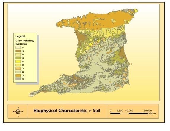
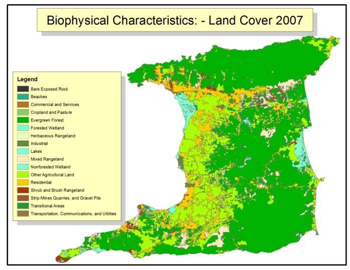
4 Geomorphology and Land cover 2007


5 Roads and Building Density

6 Slope and Soils Erosion

7
8
9 THE CONSEQUENCES


10 Damage to Buildings in Haiti due to the Earthquake of 2010
11 Risk Management Framework Risk managemen t Descriptio n of intention Hazard mapping Risk evaluation Vulnerabilit y assessment Risk estimation Estimation of probability of consequenc es Estimation of magnitude of consequenc es
12 EARTHQUAKE RISK ASSESSMENT What is Risk? Risks are an integral part of life and since risk cannot be completely eliminated, the only possible option is to assess and manage it. The first step in risk assessment is to find out what the problems are. This involves evaluating the significance of a given quantitative measure of risk in an integrated way.
13 EARTHQUAKE RISK ASSESSMENT Earthquake risk assessment encompasses the range of studies required to estimate the likelihood and potential consequences of a specific set of earthquakes of different magnitudes and intensities. Seismic scientists and engineers provide the key decision-makers with a description of the nature of the earthquake risk in specific regions as well as the degree of uncertainty surrounding such estimates. Quantitative estimates of seismic risk are important for judging whether earthquakes represent a substantial threat at any location as they enable objective weighting of earthquake risk relative to other natural hazards and other priorities for making design and retrofit decisions (NRC, 1996.)
14 Methods 4 major steps (Batuk et al 2005) 1. Hazard Analysis quantifies the physical characteristics of a hazard, including probability of occurrence, magnitude, intensity, location, influence of geological factors 2. Exposure Analysis identifies and maps underlying elements at risk or exposures, including the built environment and socioeconomic factors such as population and economic activity 3. Vulnerability Analysis: Assesses the degree of susceptibility to which elements at risk are exposed to the hazard. A common form of vulnerability analysis uses historical damage records to prescribe relationships between damage to dwellings and hazard intensity, for example different buildings and construction types will have distinct vulnerability curves, and finally 4. Risk analysis synthesizes the above three components and determines the resulting losses as a function of return period or as an exceedance probability
15 Uses of Earthquake Risk Assessment (C. Benson and J. Twigg, 2004) Predicting the expected impact of earthquake of projects Identification of appropriate risk management strategies Predicting the impact a project would have on forms and level of vulnerability in the wider community Help to formulate national policy objectives such as land use planning and building codes it provides cost efficient decision support on how to optimize investments into risk reducing measures in three situations, namely, prior, during and after an earthquake. Prof. Jacob Opadeyi National Consultation on Earthquake Safety in Trinidad and Tobago July 5-6, 2010
16 Data Required for Earthquake Risk Assessment A. Baseline data - Administrative boundary - Land cover, roads, streams etc. - Transportation and utility system - Facility and building structures - Demography (census, population distribution, density) - Economic value of asset of various sectors
17 Data Required for Earthquake Risk Assessment B. Hazard data Historical records (time, place, extent, magnitude / intensity) of earthquake hazard Geology, lithology, soil, and slope, water table Faults location, length, and depth Site condition, ground motion Existing method in hazard & risk assessment methodology
18 Data Required for Earthquake Risk Assessment C. Vulnerability data Proximity of assets to active and inactive fault lines Age of structures Population and demographic data Value and replacement cost of assets Location of critical facilities: Hospitals, Schools, Prisons, Banks, Public offices Construction materials used in buildings Location of lifelines: telecommunication, water, gas, power, transport systems
19 EARTHQUAKE RISK MANAGEMENT What is Risk Management? Risk management means reducing the threats to life, property and the environment posed by the hazard whilst simultaneously accepting unmanageable risks and maximizing any associated benefits (Smith, 1996.) Risk management involves the efforts of a variety of sectors and series of actions. In the case of earthquakes, risk management describes the role of seismic monitoring in developing alternative strategies for reducing future losses and aiding the recovery process.
20 Earthquake Risk Management Measures National risk reduction program Disaster preparedness and response plans Disaster recovery plans (National and sectoral) Earthquake hazard maps Earthquake early warning systems Landuse planning Building codes and development regulations Insurance schemes Development incentive programmes Efficient risk communication strategies Public education (use of simulators) Research and development


21 Example of Seismic Assessment Products Figure 1 Colour Coded Seismic Hazard Map pubs.usgs.gov/fs/2003/fs017-03/images/useqs.gif; Figure 2 Source: Figure 3Source: Seismic risk mapping in Germany, Tyagunov et al 2006
22 Case Study: Comprehensive Earthquake Risk Reduction Program and Action Plan: Marikina Task 1. Stakeholder User Needs Assessment: The first task will identify primary stakeholder concerns and interests. Using available GIS data and scenario modeling, it characterized stakeholder concerns in terms of known earthquake risk to valued community assets. Task 2. Data Inventory Comparison of existing GIS data resources with needs emerging from Task 1 Analyzes data collection and integration issues. Task 3. Risk Assessment Formalization of findings from a risk assessment regarding loss of housing, critical infrastructure, and economic development opportunities resulting from a 7.0 Magnitude earthquake.

23 Estimated Ground Shaking for Metro Manila in a 7.0 Magnitude Earthquake along the West Valley Fault


24 Existing and Planned Land Use Map of Metro Manila

25 Peak Ground Acceleration Map and Commercial & Industrial Areas Subject to Heavy Shaking

26 Peak Ground Acceleration Map & Critical Facilities Subject to Heavy Shaking
27 Comprehensive Earthquake Risk Reduction Program and Action Plan: Marikina Task 4. Prepare Conceptual Earthquake Risk Reduction Plan. This task created a conceptual framework based on a strategic planning process It assesses implementation options for the Comprehensive Earthquake Risk Reduction Program including locally feasible goals and objectives, policies/strategies and programs/projects for mitigation, preparedness, response, and recovery.
28 Comprehensive Earthquake Disaster Reduction Program and Action Plan: Marikina Critical Facilities Objective 1: Protect and strengthen infrastructure facilities to prevent loss of lives and damage to properties, to allow continued use, and to restore normalcy quickly following disasters. Policy 1.1: Report to the people concerned whether public and private buildings and infrastructure are in good condition Develop predisaster inventories of all utility lines to expedite post disaster identification of damaged facilities Study the replacement or upgrading of critical facilities particularly water lines. Program/Project Study the replacement or upgrading of power and telecommunication facilities. Project Establish a full coordination system with utility companies. Develop methods to ensure effective interprovider coordination systems to reasonable levels of service subsequent to a damaging earthquake
29 Critical Facilities Objective 1: Protect and strengthen infrastructure facilities to prevent loss of lives and damage to properties, to allow continued use, and to restore normalcy quickly following disasters. Policy1.2 : Preserve route functionality of roads and bridges for evacuation and logistics under all circumstances. Program/Project Study the vulnerability of existing roads and bridges and investigate possible improved locations in relation to land use Construct new major roads and bridges Retrofit infrastructure facilities which need to be strengthened.
30 Critical Facilities Objective 1: Protect and strengthen infrastructure facilities to prevent loss of lives and damage to properties, to allow continued use, and to quickly restore normalcy following disasters. Policy 1.3 : Construction of public and private facilities should take into account potential earthquake threats including liquefaction Identify earthquake hazardprone areas and areas safe for the location of public and private utilities and facilities Program/Project Modify the City Comprehensive Land Use Plan to reflect safe locations for public and private facilities Construct public and private facilities such as roads and bridges with adequate mitigation measures Require public and private facilities to address potential earthquake hazards.
31 Critical Facilities Objective 1:Protect and strengthen infrastructure facilities to prevent loss of lives and damage to properties, to allow continued use, and to restore normalcy quickly following disasters. Policy 1.4 : Restrict land uses downstream from the proposed road dike levees unless such facilities have been determined to incorporate adequate seismic stability. Program/Project Identify earthquake hazardprone areas and safe areas to locate road dike levees Develop a land use plan for the location of road dike levees Develop an evacuation plan in case of levee damage Others: New Buildings, Existing Buildings, Landuse planning, Public Education, Public Information, Research and Development, and Institutional Development
32 Comprehensive Earthquake Risk Reduction Program and Action Plan: Marikina Task 5. Plan Refinement and Implementation Strategy This task combined objectives, policies, strategies, programs and projects for mitigation, preparedness, response, and recovery actions into a Draft Comprehensive Earthquake Risk Reduction Program and Action Plan based on discussions held at stakeholders workshop. Task 6. Produce Final Products This task will include finalization of the Program and Action Plan along with Webbased materials.
33 What are the Challenges facing the Development of Earthquake Risk Assessment and Management in Trinidad & Tobago? Lack of a consistent data collection programme for risk assessment and management. Lack of an active public education programme. Capacity development and enhancement Review of relationship with related agencies Lack of a database on building structures Vulnerability assessment of communities Obtaining political support
34 Acknowledgement This presentation was prepared with support from the following graduate students: Candice Ramkisson, Gabrielle Thongs, Roxanne Smith, and Alicia Jackman
35 Thank you
SOUTH CENTRAL REGION MULTI-JURISDICTION HAZARD MITIGATION PLAN. Advisory Committee Meeting September 12, 2012
 SOUTH CENTRAL REGION MULTI-JURISDICTION HAZARD MITIGATION PLAN Advisory Committee Meeting September 12, 2012 AGENDA FOR TODAY Purpose of Meeting Engage All Advisory Committee Members Distribute Project
Kyrgyz Republic. Measuring Seismic Risk {P149630} Public Disclosure Authorized. Report No: AUS Public Disclosure Authorized.
 Public Disclosure Authorized Report No: AUS0000061 Kyrgyz Republic Public Disclosure Authorized Public Disclosure Authorized Measuring Seismic Risk {P149630} {December, 2017} URS Public Disclosure Authorized
Effective Flood Risk Assessment Methodologies
 Flood Risk Management and Urban Resilience Workshop II May 28-29, 2013 Venue: COEX, Seoul, Republic of Korea Effective Flood Risk Assessment Methodologies National Disaster Management Institute, NDMI Tae
A Flood Mitigation Plan for the Non-Tidal N.J. Section of the Delaware River Basin. Warren County Planning Workshop (2 nd Meeting) March 7, 2007
 March 7, 2007") A Flood Mitigation Plan for the Non-Tidal N.J. Section of the Delaware River Basin Warren County Planning Workshop (2 nd Meeting) March 7, 2007 Study Area Participation: Hunterdon: 16 Eligible Municipalities
A Flood Mitigation Plan for the Non-Tidal N.J. Section of the Delaware River Basin Warren County Planning Workshop (2 nd Meeting) March 7, 2007 Study Area Participation: Hunterdon: 16 Eligible Municipalities
ANNEX B: TOWN OF BLUE RIVER
 ANNEX B: TOWN OF BLUE RIVER B.1 Community Profile Figure B.1 shows a map of the Town of Blue River and its location within Summit County. Figure B.1. Map of Blue River Summit County (Blue River) Annex
Mainstreaming Disaster Risk Reduction in. Project Cycle Management
 Mainstreaming Disaster Risk Reduction in Project Cycle Management Programmes, Activities, Projects (PAP) Programmes, Activities and Projects (PAP) provide good opportunities for mainstreaming DRR in development
The Role of the Earthquake Hazard Leader in South Australia
 The Role of the Earthquake Hazard Leader in South Australia J. M. Carr 1 & S.G.Turner 2 1. Executive Director, Building Management Division, Department for Planning, Transport and Infrastructure, GPO Box
Michael Taylor, PE, CFM Project Manager, AECOM August 25, 2015
 Promoting FEMA s Flood Risk Products in the Lower Levisa Watershed Michael Taylor, PE, CFM Project Manager, AECOM August 25, 2015 Agenda Study Background Flood Risk Product Overview AOMI and Mitigation
HAZUS -MH Risk Assessment and User Group Series HAZUS-MH and DMA Pilot Project Portland, Oregon. March 2004 FEMA FEMA 436
 HAZUS -MH Risk Assessment and User Group Series HAZUS-MH and DMA 2000 Pilot Project Portland, Oregon March 2004 FEMA FEMA 436 Page intentionally left blank. Risk Assessment Pilot Project Results for DMA
Pre-Earthquake, Emergency and Contingency Planning August 2015
 RiskTopics Pre-Earthquake, Emergency and Contingency Planning August 2015 Regions that are regularly exposed to seismic events are well-known, e.g. Japan, New Zealand, Turkey, Western USA, Chile, etc.
EARTHQUAKE RISK Mustafa Erdik
 EARTHQUAKE RISK Mustafa Erdik EARTHQUAKE RISK/LOSS Loss is the reduction in value of an asset due to damage.. Risk is the uncertainty of loss. Risk or Loss estimation is the quantification of the earthquake
ASFPM Partnerships for Statewide Mitigation Actions. Alicia Williams GIS and HMP Section Manager, Amec Foster Wheeler June 2016
 ASFPM Partnerships for Statewide Mitigation Actions Alicia Williams GIS and HMP Section Manager, Amec Foster Wheeler June 2016 Summary The Concept Leveraging Existing Data and Partnerships to reduce risk
PCDIP. Philippine City Disaster Insurance Pool
 PCDIP Philippine City Disaster Insurance Pool Disaster Risk The Philippines is located in one of the world s most disaster-prone regions. Positioned on the Pacific Ring of Fire and within the Western North
C o p e r n i c u s E m e r g e n c y M a n a g e m e n t S e r v i c e f o r R i s k p l a n n i n g a n d R e c o v e r y
 C o p e r n i c u s E m e r g e n c y M a n a g e m e n t S e r v i c e f o r R i s k p l a n n i n g a n d R e c o v e r y Copernicus Service Copernicus EU Copernicus EU Copernicus EU www.copernicus.eu
Emergency Management. December 16, 2010
 Applications of Hazus-MH for Emergency Management December 16, 2010 What is Hazus-MH? Free ArcGIS extension Facilitates a risk-based approach to mitigation Identifies and visually displays hazards and
Attachment B. King County Flood Control Zone District Work Program
 Attachment B King County Flood Control Zone District Work Program The King County Flood Control Zone District work program is comprised of two major categories: Programmatic Work Program o Flood Preparedness,
Seismic (and volcanic) Risk
 Risk") Master Degree Programme in Physics - UNITS Physics of the Earth and of the Environment Seismic (and volcanic) Risk FABIO ROMANELLI Department of Mathematics & Geosciences romanel@units.it the road to (earthquake)
Master Degree Programme in Physics - UNITS Physics of the Earth and of the Environment Seismic (and volcanic) Risk FABIO ROMANELLI Department of Mathematics & Geosciences romanel@units.it the road to (earthquake)
Implementing risk-based asset management strategies
 Implementing risk-based asset management strategies 2018. 04. 17 Disaster Resilience by Design The challenge for local governments The Challenge for Local Governments Landslides Debris Flows Wildfire Wind
TERREBONNE PARISH HAZARD MITIGATION PLAN UPDATE
 TERREBONNE PARISH HAZARD MITIGATION PLAN UPDATE HAZARD MITIGATION PLAN UPDATE COMMITTEE KICK-OFF MEETING May 22, 2014 A World of Solutions 0 PRESENTATION AGENDA I. INTRODUCTIONS AND WELCOME II. PURPOSE,
Earthquakes Continuing Education Course No /264109
 Earthquakes Continuing Education Course No. 264108/264109 No. 244778), is a Professor in the Civil Engineering Department at UCLA, a California licensed engineer, and also certified with the California
Introduction to Process Safety & Risk Assessment
 Introduction to Process Safety & Risk Assessment Protection Layers University of West Indies October 4, 2013 Seminar Contents Overview of Trinidad & Tobago Process Industry Basic Concepts and Process Safety
Dade County Natural Hazard Mitigation Plan
 Introduction to Mitigation Definition of Mitigation Mitigation is defined by FEMA as "...sustained action that reduces or eliminates longterm risk to people and property from natural hazards and their
EXECUTIVE SUMMARY. Greater Greenburgh Planning Area Planning Process
 EXECUTIVE SUMMARY The Greater Greenburgh Planning Area All-Hazards Mitigation Plan was prepared in response to the Disaster Mitigation Act of 2000 (DMA 2000). DMA 2000 requires states and local governments
Risk-based Land-use Guide: Safe use of land based on hazard risk management
 Risk-based Land-use Guide: Safe use of land based on hazard risk management Bert Struik, Laurie Pearce Calgary, September 29, 2015 Messages A city-focused land-use guide is available to help reduce risk
Overview of HAZUS for Earthquake Loss Estimation. September 6, 2012
 Overview of HAZUS for Earthquake Loss Estimation September 6, 2012 What is HAZUS? Risk assessment tool for analyzing potential losses from hurricane, flood, and earthquake Uses current scientific and engineering
in coordination with Peoria County, Planning and Zoning Department
 Prepared by Amec Foster Wheeler Environment & Infrastructure Hazard Mitigation and Emergency Management Program in coordination with Peoria County, Planning and Zoning Department The purpose of hazard
Working Paper Regional Expert Group Meeting on Capacity Development for Disaster Information Management
 Working Paper Regional Expert Group Meeting on Capacity Development for Disaster Information Management A Proposal for Asia Pacific Integrated Disaster Risk Information Platform Prof. Mohsen Ghafouri-Ashtiani,
Appendix L Methodology for risk assessment
 Bay of Plenty Regional Policy Statement 347 Appendix L Methodology for risk assessment Compliance with Appendix L means: (a) (b) Use of Steps 1 to 6 below (the default methodology); or Use of a recognised
Hazard Mitigation Planning
 Hazard Mitigation Planning Mitigation In order to develop an effective mitigation plan for your facility, residents and staff, one must understand several factors. The first factor is geography. Is your
Decision support for mitigation and adaptation in a multihazard. environment. Nadejda (Nadya) Komendantova
 Komendantova") Decision support for mitigation and adaptation in a multihazard environment Nadejda (Nadya) Komendantova Natural risks and disasters are becoming an interactive mix of natural, technological and social
Decision support for mitigation and adaptation in a multihazard environment Nadejda (Nadya) Komendantova Natural risks and disasters are becoming an interactive mix of natural, technological and social
P art B 4 NATURAL HAZARDS. Natural Hazards ISSUE 1. River Flooding
 4 NATURAL HAZARDS ISSUE 1 River Flooding A large part of the plains within the Timaru District is subject to some degree of flooding risk. At least part of all of the main settlements in the District and
Strategic Flood Risk Management
 Strategic Management Duncan McLuckie (NSW Department of Infrastructure and Natural Resources) Introduction This paper discusses what is meant by strategic flood risk management, who is responsible in New
1.2 summary of the wairarapa area. 1.1 background to the wela project. 1.3 methodology
 1.1 background to the wela project The Wairarapa Engineering Lifelines Association (WELA) was formed at a public meeting held in Masterton on 21 June 1996. At that meeting were representatives from the
ENGINEERING AND CONSTRUCTION BULLETIN
 ENGINEERING AND CONSTRUCTION BULLETIN No. 2016-8 Issuing Office: CECW-CE Issued: 22 Feb 16 Expires: 22 Feb 18 SUBJECT: Interim Risk Reduction Measures (IRRMs) for Levee Safety CATEGORY: Directive and Policy
Section 2. Introduction and Purpose of the LMS
 Section 2. Introduction and Purpose of the LMS 2.1 Introduction The Disaster Mitigation Act of 2000 (DMA 2000), signed into law by the President of the United States on October 30, 2000 (P.L. 106-390),
Garfield County NHMP:
 Garfield County NHMP: Introduction and Summary Hazard Identification and Risk Assessment DRAFT AUG2010 Risk assessments provide information about the geographic areas where the hazards may occur, the value
PHASE 2 HAZARD IDENTIFICATION AND RISK ASSESSMENT
 Prioritize Hazards PHASE 2 HAZARD IDENTIFICATION AND After you have developed a full list of potential hazards affecting your campus, prioritize them based on their likelihood of occurrence. This step
REQUEST FOR PROPOSALS. Planning in Water s Way: Flood Resilient Economic Development Strategy for the I-86 Innovation Corridor
 REQUEST FOR PROPOSALS Planning in Water s Way: Flood Resilient Economic Development Strategy for the I-86 Innovation Corridor Southern Tier Central Regional Planning and Development Board (STC) is seeking
A GUIDE TO BEST PRACTICE IN FLOOD RISK MANAGEMENT IN AUSTRALIA
 A GUIDE TO BEST PRACTICE IN FLOOD RISK MANAGEMENT IN AUSTRALIA McLuckie D. For the National Flood Risk Advisory Group duncan.mcluckie@environment.nsw.gov.au Introduction Flooding is a natural phenomenon
Natural Hazards Mitigation Plan Kankakee County, Illinois Executive Summary
 1. Introduction Natural Hazards Mitigation Plan Kankakee County, Illinois Executive Summary Kankakee County is subject to natural hazards that threaten life, safety, health, and welfare and cause extensive
A GIS BASED EARTHQUAKE LOSSES ASSESSMENT AND EMERGENCY RESPONSE SYSTEM FOR DAQING OIL FIELD
 A GIS BASED EARTHQUAKE LOSSES ASSESSMENT AND EMERGENCY RESPONSE SYSTEM FOR DAQING OIL FIELD Li Li XIE, Xiaxin TAO, Ruizhi WEN, Zhengtao CUI 4 And Aiping TANG 5 SUMMARY The basic idea, design, structure
Non Regulatory Risk MAP Products Flood Depth and Probability Grids
 Non Regulatory Risk MAP Products Flood Depth and Probability Grids Virginia Floodplain Management Association 2015 Floodplain Management Workshop October 29th, 2015 Nabil Ghalayini, P.E., PMP, D.WRE, CFM
Disasters and Localities. Dr. Tonya T. Neaves Director Centers on the Public Service Schar School of Policy and Government
 Disasters and Localities Dr. Tonya T. Neaves Director Centers on the Public Service Schar School of Policy and Government INTRODUCTION Risk to disasters is increasing Population growth will inherently
BGC Project Memorandum
 Suite 500-1045 Howe Street, Vancouver, British Columbia, Canada. V6Z 2A9 Telephone (604) 684-5900 Fax (604) 684-5909 BGC Project Memorandum To: Attention: CANHUG Meeting Participants From: Kris Holm, BGC
Introduction to Disaster Management
 Introduction to Disaster Management Definitions Adopted By Few Important Agencies WHO; A disaster is an occurrence disrupting the normal conditions of existence and causing a level of suffering that exceeds
Catastrophe Risk Modelling. Foundational Considerations Regarding Catastrophe Analytics
 Catastrophe Risk Modelling Foundational Considerations Regarding Catastrophe Analytics What are Catastrophe Models? Computer Programs Tools that Quantify and Price Risk Mathematically Represent the Characteristics
ICT and Risk Governance. Asian Disaster Preparedness Center
 ICT and Risk Governance Asian Disaster Preparedness Center Governance The process of decision-making, and the process by which decisions are implemented or not implemented Risk governance A systemic approach
The new European Flood Management Directive and the municipal flood management system as one realization approach
 The new European Flood Management Directive and the municipal flood management system as one realization approach, Manuela Gretzschel University of Kaiserslautern, Germany Prof. Dr. Volker Lüderitz Magdeburg
Mitigate or Adapt Navigating the Evolving Natural Hazards Regulatory Landscape. RMLA Roadshow 2016 Marje Russ, Tonkin + Taylor Maurice Hoban, GHD
 Mitigate or Adapt Navigating the Evolving Natural Hazards Regulatory Landscape RMLA Roadshow 2016 Marje Russ, Tonkin + Taylor Maurice Hoban, GHD Photo: Sugar Loaf Wharf, Coromandel. Jan 4 2014, Stuart
PLANNING PROCESS. Table of Contents. List of Tables
 PLANNING PROCESS Table of Contents 1.1 Narrative Description of the Planning Process... 1-1 1.2 Steering Committee & Public Involvement... 1-7 1.2.1 Steering Committee Participant Solicitation... 1-7 1.2.2
15. Natural Hazards. Submission No. and Point / Submitter Name. Plan Provision Summary of Submission Decision Requested. General
 15. Submission No. 2.4 Bluff Community Board 56.14 Jenny Campbell 64.33 Department of Conservation 116.3 Kylie Fowler 117.10 Southern District Health Board - tsunami There is a lack of information for
THE FEDERAL DEMOCRATIC REPUBLIC OF ETHIOPIA NATIONAL POLICY AND STRATEGY ON DISASTER RISK MANAGEMENT. July 2013 Addis Ababa
 THE FEDERAL DEMOCRATIC REPUBLIC OF ETHIOPIA NATIONAL POLICY AND STRATEGY ON DISASTER RISK MANAGEMENT July 2013 Addis Ababa 1 Content 1. Introduction... 3 2. Policy Vision,Mission and Objectives... 4 3.Policy
IMPLEMENTATION OF THE IDNDR-RADIUS PROJECT IN LATIN AMERICA
 IMPLEMENTATION OF THE IDNDR-RADIUS PROJECT IN LATIN AMERICA Carlos A VILLACIS 1 And Cynthia N CARDONA 2 SUMMARY In 1996, the Secretariat of the International Decade for Natural Disaster Reduction (IDNDR),
Understanding CCRIF s Hurricane, Earthquake and Excess Rainfall Policies
 Understanding CCRIF s Hurricane, Earthquake and Excess Rainfall Policies Technical Paper Series # 1 Revised March 2015 Background and Introduction G overnments are often challenged with the significant
Climate and Disaster Risk Assessment in Land Use Planning
 Climate and Disaster Risk Assessment in Land Use Planning Experience from the Housing and Land Use Regulatory Board Technical Planning Assistance Program (HTPAP): The Case of Gloria, Oriental Mindoro in
DO WE NEED TO CONSIDER FLOODS RARER THAN 1% AEP?
 DO WE NEED TO CONSIDER FLOODS RARER THAN 1% AEP? Drew Bewsher and John Maddocks Bewsher Consulting Pty Ltd Abstract Everyone is aware that floods rarer than the 1% AEP event occur. Australia-wide, over
Hazard Mitigation Grants. Technical Assistance Session Middlesex County, NJ December 7, 2011
 Hazard Mitigation Grants Technical Assistance Session Middlesex County, NJ December 7, 2011 Outline Purpose of Hazard Mitigation Hazard Mitigation Projects Hazard Mitigation Assistance Grant Programs Using
Planning Process---Requirement 201.6(b): An open public involvement process is essential to the development of an effective plan.
: An open public involvement process is essential to the development of an effective plan.") Section 3 Capability Identification Requirements Planning Process---Requirement 201.6(b): An open public involvement process is essential to the development of an effective plan. Documentation of the Planning
Section 3 Capability Identification Requirements Planning Process---Requirement 201.6(b): An open public involvement process is essential to the development of an effective plan. Documentation of the Planning
Terms of Reference (ToR) Earthquake Hazard Assessment and Mapping Specialist
 Earthquake Hazard Assessment and Mapping Specialist") Terms of Reference (ToR) Earthquake Hazard Assessment and Mapping Specialist I. Introduction With the support of UNDP, the Single Project Implementation Unit (SPIU) of the Ministry of Disaster Management
Terms of Reference (ToR) Earthquake Hazard Assessment and Mapping Specialist I. Introduction With the support of UNDP, the Single Project Implementation Unit (SPIU) of the Ministry of Disaster Management
Flood risk assessment for sustainable urban development : Case study of Marikina-Pasig-San Juan river basin, Manila
 International Conference in Urban and Regional Planning "Planning towards Sustainability and Resilience" 14 15 March, 2018 Manila, Philippines Flood risk assessment for sustainable urban development :
Sharm El Sheikh Declaration on Disaster Risk Reduction. 16 September Adopted at the Second Arab Conference on Disaster Risk Reduction
 Sharm El Sheikh Declaration on Disaster Risk Reduction 16 September 2014 Adopted at the Second Arab Conference on Disaster Risk Reduction City of Sharm El Sheikh, Arab Republic of Egypt, 14 16 September
Uncertainty Propagation of Earthquake Loss Estimation System On The Early Seismic Damage Evaluation
 Uncertainty Propagation of Earthquake Loss Estimation System On The Early Seismic Damage Evaluation Chi-Jan Huang Graduate Institution of Engineering National Taipei University of Taipei, Taiwan, R.O.C.
LIFE CYCLE ASSET MANAGEMENT. Project Management Overview. Good Practice Guide GPG-FM-001. March 1996
 LIFE YLE Good Practice Guide ASSET MANAGEMENT Project Management Overview March 1996 Department of Energy Office of Field Management Office of Project and Fixed Asset Management ontents 1. INTRODUTION...1
EXECUTIVE SUMMARY. Onondaga County Multi-Jurisdictional Planning Process
 EXECUTIVE SUMMARY The Onondaga County Multi-Jurisdictional All-Hazards Mitigation Plan was prepared in response to the Disaster Mitigation Act of 2000 (DMA 2000). DMA 2000 requires states and local governments
A Multihazard Approach to Building Safety: Using FEMA Publication 452 as a Mitigation Tool
 Mila Kennett Architect/Manager Risk Management Series Risk Reduction Branch FEMA/Department of Homeland Security MCEER Conference, September 18, 2007, New York City A Multihazard Approach to Building Safety:
EVALUATING OPTIMAL STRATEGIES TO IMPROVE EARTHQUAKE PERFORMANCE FOR COMMUNITIES
 EVALUATING OPTIMAL STRATEGIES TO IMPROVE EARTHQUAKE PERFORMANCE FOR COMMUNITIES Anju GUPTA 1 SUMMARY This paper describes a new multi-benefit based strategy evaluation methodology to will help stakeholders
The approach to managing natural hazards in this Plan is to: set out a clear regional framework for natural hazard management
 10 Natural Hazards 10.1 Scope and Background This chapter establishes an overall framework for natural hazard management under the Resource Management Act 1991 (RMA). It also sets out the division of responsibilities
Federal Floodplain Mapping Guideline Series. CRHNet 2017 Symposium Halifax, Nova Scotia October 25, 2017
 Federal Floodplain Mapping Guideline Series CRHNet 2017 Symposium Halifax, Nova Scotia October 25, 2017 Overview 1. Introduction to Floodplain Maps 2. Federal Floodplain Mapping Guidelines Series 3. Stakeholder
PROGRAM OF INDICATORS OF DISASTER RISK AND RISK MANAGEMENT IN THE AMERICAS. Review and Update. Omar D. Cardona
 PROGRAM OF INDICATORS OF DISASTER RISK AND RISK MANAGEMENT IN THE AMERICAS Review and Update Omar D. Cardona IRDR SC Member National University of Colombia ERN Evaluación de Riesgos Naturales - América
Section 19: Basin-Wide Mitigation Action Plans
 Section 19: Basin-Wide Mitigation Action Plans Contents Introduction...19-1 Texas Colorado River Floodplain Coalition Mitigation Actions...19-2 Mitigation Actions...19-9 Introduction This Mitigation Plan,
APPLICATION OF EARLY SEISMIC LOSS ESTIMATION (ESLE) IN DISASTER MANAGEMENT
 IN DISASTER MANAGEMENT") APPLICATION OF EARLY SEISIC LOSS ESTIATION (ESLE) IN DISASTER ANAGEENT Chu-Chieh Jay LIN*, Chin-Hsun YEH** Associate Research Fellow, National Center for Research on Earthquake Engineering, Taipei, Taiwan*
APPLICATION OF EARLY SEISIC LOSS ESTIATION (ESLE) IN DISASTER ANAGEENT Chu-Chieh Jay LIN*, Chin-Hsun YEH** Associate Research Fellow, National Center for Research on Earthquake Engineering, Taipei, Taiwan*
Hazard Mitigation FAQ
 Hazard Mitigation FAQ What is Hazard Mitigation? Actions taken to reduce or eliminate the long-term risk to people, property, or the environment from hazards and their effects. Examples: Hazardous Area
Frequently Asked Questions Oxbow / Hickson / Bakke Ring Levee Option
 Frequently Asked Questions Oxbow / Hickson / Bakke Ring Levee Option October 16, 2012 Q1. Why has the position on a ring-levee changed? The feasibility study recommended buy-outs for areas with staging
33. Government financial support to local authorities
 33. Government financial support to local authorities Summary Specific government financial support to local authorities during or after an emergency is based on a range of mandates, criteria, and triggers,
3D Elevation Program (3DEP) Status and Plans. Kevin T. Gallagher Associate Director, Core Science Systems June 26, 2017
 Status and Plans. Kevin T. Gallagher Associate Director, Core Science Systems June 26, 2017") + 3D Elevation Program (3DEP) Status and Plans Kevin T. Gallagher Associate Director, Core Science Systems June 26, 2017 + 2 3D Elevation Program (3DEP) Apply lidar technology to map bare earth and 3D
+ 3D Elevation Program (3DEP) Status and Plans Kevin T. Gallagher Associate Director, Core Science Systems June 26, 2017 + 2 3D Elevation Program (3DEP) Apply lidar technology to map bare earth and 3D
School District Mitigation Planning 101 April 28 th 30 th 2014
 School District Mitigation Planning 101 April 28 th 30 th 2014 Kenneth A. Goettel Goettel & Associates Inc. 1732 Arena Drive Davis, CA 95618 (530) 750-0440 KenGoettel@aol.com What is Hazard Mitigation?
Somerset County Mitigation Plan Update
 Somerset County Multi-Jurisdictional Hazard Mitigation Plan Update Kickoff Meeting Agenda Kickoff Meeting September 28, 2017 6:00 pm SCES, 402 Roycefield Road, Hillsborough, NJ Welcome and Opening Remarks.....
Catastrophe Risk Modeling and Application- Risk Assessment for Taiwan Residential Earthquake Insurance Pool
 5.00% 4.50% 4.00% 3.50% 3.00% 2.50% 2.00% 1.50% 1.00% 0.50% 0.00% 0 100 200 300 400 500 600 700 800 900 1000 Return Period (yr) OEP20050930 Catastrophe Risk Modeling and Application Risk Assessment for
According to the U.S. Geological
 Estimating economic losses in the Bay Area from a magnitude-6.9 earthquake Data from the BLS Quarterly Census of Employment and Wages are used to analyze potential business and economic losses resulting
Sussex County All Hazard Mitigation Plan. Plan Executive Summary
 Sussex County All Hazard Mitigation Plan Plan Executive Summary March 2010 SUSSEX COUNTY ALL HAZARD MITIGATION PLAN SUMMARY March 2010 For questions and to make comments on this document, contact: Joseph
Natural Hazards Mitigation Plan. Executive Summary
 Natural Hazards Mitigation Plan Executive Summary 1. Introduction Kane County Illinois, is subject to natural hazards that threaten life and health and have caused extensive property damage. Floods struck
Palu, Indonesia. Local progress report on the implementation of the 10 Essentials for Making Cities Resilient ( )
") Palu, Indonesia Local progress report on the implementation of the 10 Essentials for Making Cities Resilient (2013-2014) Name of focal point: Yusniar Nurdin Organization: BNPB Title/Position: Technical
Palu, Indonesia Local progress report on the implementation of the 10 Essentials for Making Cities Resilient (2013-2014) Name of focal point: Yusniar Nurdin Organization: BNPB Title/Position: Technical
G318 Local Mitigation Planning Workshop. Module 2: Risk Assessment. Visual 2.0
 G318 Local Mitigation Planning Workshop Module 2: Risk Assessment Visual 2.0 Unit 1 Risk Assessment Visual 2.1 Risk Assessment Process that collects information and assigns values to risks to: Identify
Earthquake 2005 Recovery and Reconstruction
 Earthquake 2005 Recovery and Reconstruction 2 Earthquake 8 Oct 2005 Nine Districts 1. MANSHERA 2. BATAGRAM 3. SHANGLA 4. ABBOTTABAD 5. KOHISTAN Epicentre 6. MUZAFFARABAD 7. NELUM 8. BAGH 9. RAWALAKOT Depth:
County of Kaua'i Multi-Hazard Mitigation and Resilience Plan, 2015 Update
 Executive Summary: County of Kaua'i Multi-Hazard Mitigation and Resilience Plan Introduction to the Mitigation and Resilience Plan In this third plan, the longer term needs for sustaining mitigation efforts
2.3 Risk Management Flow
 2.3 Risk Management Flow To reduce disaster risk, it is important to take implement risk management procedures step by step. The disaster risk management flow under TDRM is illustrated in Figure 2.3. (1)
Community Based Disaster Risk Management
 Community Based Disaster Risk Management. Disaster management Disaster management can be defined as the effective organization, direction and utilization of available counterdisaster resources. Disaster
Disaster Risk Reduction and Management in St. Lucia
 Disaster Risk Reduction and Management in St. Lucia National Circumstances Saint Lucia is a Small Island Developing State (SIDS) located at latitude 13 o N, and 61 o S within the Lesser Antilles. The
SECTION 6: MITIGATION STRATEGIES
 SECTION 6: MITIGATION STRATEGIES This section presents mitigation actions for Somerset County to reduce potential exposure and losses identified as concerns in the Risk Assessment portion of this plan.
Flood Risk Review and Resilience Meeting: Allegheny County
 Flood Risk Review and Resilience Meeting: Allegheny County Allegheny County Conservation District Building December 5-6, 2012 Introductions Risk MAP Project Team Local partners and officials State partners
The Earthquake Commission s earthquake insurance loss model
 The Earthquake Commission s earthquake insurance loss model R.B. Shephard, D.D. Spurr, G.R. Walker NZSEE 2002 Conference Seismic Consultants Ltd, Spurr Consulting, Aon Re Australia ABSTRACT: The Earthquake
Northern Kentucky University 2018 Hazard Mitigation Plan. Public Kick-Off Meeting March 20, 2018
 Northern Kentucky University 2018 Hazard Mitigation Plan Public Kick-Off Meeting March 20, 2018 Agenda Welcome Hazard Mitigation Planning 101 Hazard Identification Exercises Next Steps Jeff Baker, NKU
RESOLUTION NO. WHEREAS, the Signal Hill Safety Element was last updated in 1986; and
 RESOLUTION NO. A RESOLUTION OF THE PLANNING COMMISSION OF THE CITY OF SIGNAL HILL, CALIFORNIA, RECOMMENDING CITY COUNCIL APPROVAL OF GENERAL PLAN AMENDMENT 16-02 ADOPTING THE 2016 SAFETY ELEMENT UPDATE
Q1 Do you...(check all that apply).
.") Q1 Do you...(check all that apply). Live in the City of... Work in the City of... Visit the City of Hesperia... Live in the City of Hesperia Work in the City of Hesperia Visit the City of Hesperia but
Q1 Do you...(check all that apply). Live in the City of... Work in the City of... Visit the City of Hesperia... Live in the City of Hesperia Work in the City of Hesperia Visit the City of Hesperia but
APPENDIX 1 FEMA MITIGATION GRANT PROGRAMS
 APPENDIX 1 FEMA MITIGATION GRANT PROGRAMS 2016 FEMA FUNDING POSSIBILITIES FOR SCHOOL DISTRICTS IN WASHINGTON Overview For public entities in Washington, including school districts, FEMA mitigation funding
Delineating hazardous flood conditions to people and property
 Delineating hazardous flood conditions to people and property G Smith 1, D McLuckie 2 1 UNSW Water Research Laboratory 2 NSW Office of Environment and Heritage, NSW Abstract Floods create hazardous conditions
Bone Bolango, Indonesia
 Bone Bolango, Indonesia Local progress report on the implementation of the 10 Essentials for Making Cities Resilient (2013-2014) Name of focal point: Yusniar Nurdin Organization: BNPB Title/Position: Technical
FEMA s Flood Map Modernization Preparing for FY09 and Beyond: Integrated Flood Data Update, Risk Assessment, and Mitigation Planning
 FEMA s Flood Map Modernization Preparing for FY09 and Beyond: Integrated Flood Data Update, Risk Assessment, and Mitigation Planning DRAFT CONCEPT PAPER June 1, 2007 Integrated Flood Data Update, Risk
Risk Based Approaches for Levees in the U.S. and Abroad: Lessons for the NFIP
 Proud Platinum Sponsor of the ASFPM 2017 Annual Conference Risk Based Approaches for Levees in the U.S. and Abroad: Lessons for the NFIP Mike Seering (AECOM) David Powers (HR Wallingford) ASFPM 2017 Annual
Government Decree on Flood Risk Management 659/2010
 Ministry of Agriculture and Forestry, Finland NB: Unofficial translation; legally binding texts are those in Finnish and Swedish. Government Decree on Flood Risk Management 659/2010 Section 1 Preliminary