AGENDA ITEM SUMMARY April 19, 2016 City Council
|
|
|
- Madison Linda Jennings
- 5 years ago
- Views:
Transcription

1 Agenda Item 15 AGENDA ITEM SUMMARY April 19, 2016 City Council STAFF Rita Knoll, Chief Deputy City Clerk Wanda Winkelmann, City Clerk SUBJECT First Reading of Ordinance No. 055, 2016, Amending the City of Fort Collins District-Precinct Map. EXECUTIVE SUMMARY The purpose of this item is to amend the City of Fort Collins District-Precinct Map to (1) align the City precinct boundaries with the County precinct boundaries, which were amended in May 2015; and (2) adjust Council district boundaries to achieve a required population deviation between the most populous district and the least populous district. The district boundaries were last adjusted in August STAFF RECOMMENDATION Staff recommends adoption of the Ordinance on First Reading with a map option selected by the Council. BACKGROUND / DISCUSSION Prior Consideration Council recently considered this item at its January 19, 2016 meeting and adopted the Ordinance on First Reading with map Option 1 selected. Prior to Second Reading, citizen concerns were raised about the completeness of the public notice. Additionally, staff became aware that the data obtained from the State Demographer did not include populations residing on Colorado State University (CSU) property, and staff withdrew the item on Second Reading. Staff has now republished the notice, obtained the CSU data, and is presenting a new Ordinance with four possible map options. Precinct Boundary Changes State statute requires the County to set precinct boundaries so that no more than 2,000 eligible electors reside in a precinct. Population increases in some areas made it necessary for precincts to be divided to comply with the law. Within Fort Collins, six precincts were divided, none of which affected District boundaries. The City needs to adjust precinct boundaries to match the new County precinct boundaries, which is necessary to access voter registration information. Council District Boundaries Because staff was undertaking a review of the district-precinct map for precinct boundary changes, staff used the opportunity to review the population deviation as well. This review was originally scheduled to take place in 2016 for revision in early Item # 15 Page 1
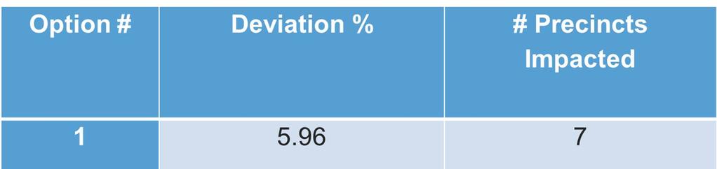
2 Agenda Item 15 It was determined that based on the current data, the current deviation between the most populous district and the least populous district exceeds 19%, nearly twice the threshold set out in the City Code. Therefore, staff is recommending that an adjustment be made now rather than in The GIS Division has an established methodology for population-based redistricting (Attachment 1). This methodology was applied and four options were developed for adjusting the district boundaries, as outlined below. In addition to balancing the population between districts, staff also considered the following: (1) Alignment of district boundaries to precinct boundaries; and (2) The residence address of each Councilmember, so that no Councilmember is disenfranchised from his or her district. The options presented from consideration are described below: Option 1 (identical to the January 19 Option 1) Achieves the smallest deviation: 5.96% (slightly higher than the original Option 1) Moves 7 precincts into different districts. - As a result, 2 precincts that voted for a district representative in 2015 would choose a representative in their new district in 2017; the other 5 precincts that chose a district representative in 201 would wait until 2019 to elect a representative in their new district. Option 2 (identical to the January 19 Option 2) Deviation: 7.54% (considerably higher than the original Option 2) Moves 8 precincts into different districts. - As a result, precincts that voted for a district representative in 2015 would choose a representative in their new district in 2017; the other 5 precincts that chose a district representative in 201 would wait until 2019 to elect a representative in their new district. Option (new) Deviation: 6.05% Moves 8 precincts into different districts. - As a result, precincts that voted for a district representative in 2015 would choose a representative in their new district in 2017; 5 precincts that chose a district representative in 201 would wait until 2019 to elect a representative in their new district. Option 4 (new) Deviation: 6.02% Moves 4 precincts into different districts. - As a result, 1 precinct that voted for a district representative in 2015 would choose a representative in its new district in 2017; the other precincts that chose a district representative in 201 would wait until 2019 to elect a representative in their new district. In each of these options, the ability to vote for Mayor, and ballot issues, is not affected. Also attached is a map visually depicting growth in the city, as well as a map depicting growth trends (Attachment 2). All four maps are attached to the Ordinance as Exhibit A (Options 1 through 4). Once a map option is selected on First Reading, the selected map will become the only exhibit to the Ordinance for Second Reading. Item # 15 Page 2
3 Agenda Item 15 PUBLIC OUTREACH As required by Section 7-87 of the City Code, two notices of this hearing were published, one no less than 14 days and one no less than 10 days prior to Council consideration on first reading. Publication of those notices occurred on April and April 6, Map options were made available on the City's web page devoted to Council district boundaries. ATTACHMENTS 1. Redistricting Methodology (PDF) 2. City Growth Trends (PDF). Redistricting Notice (PDF) 4. Powerpoint presentation (PPTX) Item # 15 Page

4 ATTACHMENT 1 GIS 215 N Mason St PO Box 580 Fort Collins, CO fax Population Based Redistricting Methodology This document is intended to define the process for redistricting within the City of Fort Collins. There are two distinct processes to follow depending on when the redistricting is being conducted. The first process uses the census data and is done the year following the census. The second process is done in any of the interim years as needed. Both processes will use estimated population, not projected population. Process 1 The GIS division will use population data collected in the Decennial Census. This information is available approximately in the first quarter following the census year (example: 2010 Census data should be available in the first three months of 2011). There are two components to this information; the database containing population and the TIGER (Topologically Integrated Geographic Encoding and Referencing system) block data. The TIGER Census Blocks are the smallest geographic area for which population data is available. To avoid the pretense of using any race, age, gender, etc information in the redistricting process, all data other then the population will be purged from the database prior to analysis. To make this data usable for the redistricting process the TIGER boundary lines need to be spatially adjusted to match the features that they represent (example: lines in the TIGER data representing the corporate limits may need to be adjusted so that they exactly match our GIS corporate limits). Once this is completed the population data can be joined to the Block features and population counts can be determined for each precinct and district. The GIS department will then shift precincts into adjacent districts to balance each district s population size according to the city charter. Multiple sceneries can be developed for these changes with the final result being an adopted District Precinct map.
.")
5 Process 2 Any time a population estimate is needed between census years, the population information will come from the Colorado State Demographer. This information is released annually in November and is the population estimate for the prior year (example: 2005 population estimates are released in November 2006). The state uses information unavailable to the municipalities to help determine these estimates. Information such as births, deaths, immigration, vacancy rates, and building permits are incorporated into the estimate. By using the state s numbers, GIS will have a population estimate that is consistent with other departments within the city (The City Planning Department uses these numbers as well). By using the last census as the base population the GIS department can determine the population increase. The City of Fort Collins does not have any building permit data for CSU so GIS needs to use a different method to get population changes on campus. These estimates for CSU s main campus will come from the Executive Director, Housing and Dining Services at CSU. By requesting multiple year population totals per residence hall and apartment complexes, GIS will be able to determine the population increase for CSU managed properties. Each residence hall and apartment complex will have a GIS point created with the population change. This spatially locates where the population changes occur. This increase/decrease will be directly applied to the appropriate precincts. By subtracting the CSU population increase from the overall population increase, GIS will have the population increase that needs to be distributed over the rest of the city. The remaining population increase can be divided by the number of housing units that have been built or annexed since the previous census creating a population distribution per housing unit. The GIS department will geocode the building permits (spatially locate the permit by address) determining the census block the permits are in. GIS will also look at annexations that have occurred since the census and determine the approximate number of housing units that were added. The process will determine the number of housing units added to each census block. With this information GIS can then distribute the population increase to the various blocks. The population counts can be determined for each precinct and district. The GIS department will then shift precincts into adjacent districts to balance each district s population size according to the city charter. Multiple sceneries can be developed for these changes with the final result being an adopted District Precinct map.
6 S COUNTY ROAD 19 S US HIGHWAY 287 S TAFT HILL RD S TIMBERLINE RD MAIN ST N COUNTY ROAD 5 BIN GHAM S COUNTY ROAD 2 HILL RD 64 COUNTY ROAD 42C S CENTENNIAL DR OVERLAND TRL N COUNTY ROAD 54G S OVERLAND TRL N US HIGHWAY N TAFT HILL RD LAPORTE AVE WXYZÉ W ELIZABETH ST W VINE DR W PROSPECT RD W DRAKE RD City of Fort Collins City Growth N COUNTY ROAD 17 N SHIELDS ST W MULBERRY ST 7 W HORSETOOTH RD W HARMONY RD W TRILBY RD W DOUGLAS RD W WILLOX LN W MOUNTAIN AVE W LAUREL ST 47 N COLLEGE AVE S COLLEGE AVE 9 14 TERRY LAKE RD E WILLOX LN 2 41 GREGORY RD COUNTRY CLUB RD TH ST N LEMAY AVE RIVERSIDE AVE LEMAY AVE S TURNBERRY RD E LINCOLN AVE E DRAKE RD E HORSETOOTH RD E TRILBY RD CARPENTER RD E DOUGLAS RD E VINE DR S COUNTY ROAD E HARMONY RD 5 N TIMBERLINE RD GIDDINGS RD N COUNTY ROAD 9 RICHARDS LAKE RD MOUNTAIN VISTA DR E MULBERRY ST S SUMMIT VIEW DR E PROSPECT RD 29 ZIEGLER RD 9 S COUNTY ROAD 9 0 E COUNTY ROAD 0 6 KECHTER RD 5 STRAUSS CABIN RD E COUNTY ROAD 52 E COUNTY ROAD 50 STATE HIGHWAY 92 ATTACHMENT 2 E COUNTY ROAD 48!"`$ E COUNTY ROAD 8 S COUNTY ROAD 5 Scale 1:62,856 Miles CITY OF FORT COLLINS GEOGRAPHIC INFORMATION SYSTEM MAP PRODUCTS These map products and all underlying data are developed for use by the City of Fort Collins for its internal purposes only, and were not designed or intended for general use by members of the public. The City makes no representation or warranty as to its accuracy, timeliness, or completeness, and in particular, its accuracy in labeling or displaying dimensions, contours, property boundaries, or placement of location of any map features thereon. THE CITY OF FORT COLLINS MAKES NO WARRANTY OF MERCHANTABILITY OR WARRANTY FOR FITNESS OF USE FOR PARTICULAR PURPOSE, EXPRESSED OR IMPLIED, WITH RESPECT TO THESE MAP PRODUCTS OR THE UNDERLYING DATA. Any users of these map products, map applications, or data, accepts them AS IS, WITH ALL FAULTS, and assumes all responsibility of the use thereof, and further covenants and agrees to hold the City harmless from and against all damage, loss, or liability arising from any use of this map product, in consideration of the City's having made this information available. Independent verification of all data contained herein should be obtained by any users of these products, or underlying data. The City disclaims, and shall not be held liable for any and all damage, loss, or liability, whether direct, indirect, or consequential, which arises or may arise from these map products or the use thereof by any person or entity. Population Calculations 2010 Census 2014 Population Population (State Demographer) 14, ,570 Population Change New Units (Built and Annexed) Population Per Unit 10,582 4, Council Districts Mayor - Wade Troxell District 1 - Bob Overbeck District 2 - Ray Martinez District - Gino Campana District 4 - Kristin Stephens District 5 - Ross Cunniff District 6 - Gerry Horak Council Member Locations Units Added More Units Fewer Units Development Projects Printed: March 10, 2016
7 S COUNTY ROAD 19 S US HIGHWAY 287 S TAFT HILL RD S TIMBERLINE RD MAIN ST N COUNTY ROAD 5 BINGHAM S COUNTY ROAD 2 HILL RD 64 COUNTY ROAD 42C S CENTENNIAL DR OVERLAND TRL N N US HIGHWAY 287 COUNTY ROAD 54G S OVERLAND TRL N TAFT HILL RD LAPORTE AVE WXYZÉ W ELIZABETH ST W VINE DR W PROSPECT RD W DRAKE RD City of Fort Collins City Growth (Trending) N COUNTY ROAD 17 N SHIELDS ST W MULBERRY ST 7 W HORSETOOTH RD W HARMONY RD W TRILBY RD W DOUGLAS RD W WILLOX LN W MOUNTAIN AVE W LAUREL ST 47 N COLLEGE AVE SCOLLEGEAVE LAKE RD TERRY 9 14 E WILLOX LN 2 41 GREGORY RD COUNTRY CLUB RD TH ST N LEMAY AVE RIVERSIDE AVE LEMAY AVE S TURNBERRY RD E LINCOLN AVE E DRAKE RD E HORSETOOTH RD CARPENTER RD E TRILBY RD E DOUGLAS RD E VINE DR 1 28 S COUNTY ROAD E HARMONY RD 5 N TIMBERLINE RD GIDDINGS RD N COUNTY ROAD 9 RICHARDS LAKE RD MOUNTAIN VISTA DR E MULBERRY ST S SUMMIT VIEW DR E PROSPECT RD 29 ZIEGLER RD 9 S COUNTY ROAD 9 0 E COUNTY ROAD 0 6 KECHTER RD 5 STRAUSS CABIN RD E COUNTY ROAD 52 E COUNTY ROAD 50 STATE HIGHWAY 92 E COUNTY ROAD 48!"`$ E COUNTY ROAD 8 S COUNTY ROAD 5 Scale 1:6,60 Miles CITY OF FORT COLLINS GEOGRAPHIC INFORMATION SYSTEM MAP PRODUCTS These map products and all underlying data are developed for use by the City of Fort Collins for its internal purposes only, and were not designed or intended for general use by members of the public. The City makes no representation or warranty as to its accuracy, timeliness, or completeness, and in particular, its accuracy in labeling or displaying dimensions, contours, property boundaries, or placement of location of any map features thereon. THE CITY OF FORT COLLINS MAKES NO WARRANTY OF MERCHANTABILITY OR WARRANTY FOR FITNESS OF USE FOR PARTICULAR PURPOSE, EXPRESSED OR IMPLIED, WITH RESPECT TO THESE MAP PRODUCTS OR THE UNDERLYING DATA. Any users of these map products, map applications, or data, accepts them AS IS, WITH ALL FAULTS, and assumes all responsibility of the use thereof, and further covenants and agrees to hold the City harmless from and against all damage, loss, or liability arising from any use of this map product, in consideration of the City's having made this information available. Independent verification of all data contained herein should be obtained by any users of these products, or underlying data. The City disclaims, and shall not be held liable for any and all damage, loss, or liability, whether direct, indirect, or consequential, which arises or may arise from these map products or the use thereof by any person or entity. Population Calculations 2010 Census 2014 Population Population (State Demographer) 14, ,570 Population Change New Units (Built and Annexed) Population Per Unit 10,582 4, Council Districts District 1 - Bob Overbeck District 2 - Ray Martinez District - Gino Campana District 4 - Kristin Stephens District 5 - Ross Cunniff District 6 - Gerry Horak Council Member Locations Jan - Oct 2015 Fewer Units More Units Development Projects Printed: March 10, 2016

8 ATTACHMENT


9 District-Precinct Map Amendment Wanda Winkelmann, City Clerk 1
10 The purpose of this item is to: Amending the District-Precinct Map Establish City precincts (which match the County precinct boundaries); and Establish Council district boundaries. 2
11 Background Precinct boundaries were amended by Larimer County in May 2015 to accommodate the increase in the number of registered voters. Council District boundaries were last amended in August 2012, following the official publication of the decennial Census. Our City Code mandates that Council District boundaries be reviewed not less than once every five years.
12 Council District Boundaries Recent review of the existing Council District boundaries revealed that the current deviation exceeds 20%. Staff brought this to Council in January and, to ensure notice requirements were met, it is being reintroduced. CSU population data is included in the options. 4

13 Options 5
14 Recommendation Staff recommends Council select one of the four options and adopt the Ordinance on first reading. The selected option will become an exhibit to the Ordinance on second reading. 6
15 ORDINANCE NO. 055, 2016 OF THE COUNCIL OF THE CITY OF FORT COLLINS AMENDING THE CITY OF FORT COLLINS DISTRICT-PRECINCT MAP WHEREAS, Article II, Section 1 of the City Charter requires that the City be divided into six contiguous, reasonably compact City Council districts, each of which shall consist of contiguous, undivided general election precincts, and, to the extent reasonably possible, an equal number of inhabitants; and WHEREAS, pursuant to City Code Section 7-87(b), not less than 180 days after the official decennial publication of the United States Census concerning the population of Fort Collins, the City Clerk must recommend to the City Council any district boundary changes necessary to ensure that, to the extent reasonably possible, there is no more than a ten-percent (10%) deviation between the most populous and the least populous City Council districts; and WHEREAS, City Code Section 7-87(c) requires a review of the district boundaries not less than once every five (5) years after making the decennial post-census determination, to determine whether the maximum deviation between the most populous and the lest populous district meets the ten-percent deviation standard set forth in Section 7-87(b); and WHEREAS, staff recently completed a review of the composition of the existing districts of the City, and has determined that, as currently configured, the deviation between the most and least populous City Council districts exceeds twenty percent; and WHEREAS, pursuant to the above-referenced provisions of the City Code, the City Clerk has presented four alternative district boundary changes for the City Council's consideration from which the City Council has selected an alternative that it believes best serves the interests of the residents of the City and comports with the requirements of the City Charter and Code; and WHEREAS, Larimer County recently revised its precinct boundaries and it is advisable for the City to match those precinct boundaries for purposes of accessing and using voter registration records; and WHEREAS, the City Clerk caused the publication of notices of proposed district boundary amendments to be made in accordance with the requirements of City Code Section 7-87; and WHEREAS, the new Council district-precinct map attached as Exhibit A depicts adjusted precinct boundaries and adjusted Council district boundaries. NOW, THEREFORE, BE IT ORDAINED BY THE COUNCIL OF THE CITY OF FORT COLLINS as follows: -1-
16 Section 1. That the City Council hereby makes and adopts the determinations and findings contained in the recitals set forth above. Section 2. That the district-precinct map dated March 9, 2016, a copy of which is attached as Exhibit A [Option 1, 2, or 4] and incorporated herein by this reference, is hereby adopted and shall be in effect for the following purposes: (1) determining eligibility for City Council offices for the April 4, 2017, regular municipal election; and (2) determining eligibility of any interim appointments to fill any City Council vacancies which may occur following the effective date of this Ordinance. Introduced, considered favorably on first reading, and ordered published this 19th day of April, A.D. 2016, and to be presented for final passage on the rd day of May, A.D ATTEST: Mayor City Clerk Passed and adopted on final reading on the rd day of May, A.D ATTEST: Mayor City Clerk -2-
17 S COUNTY ROAD 19 S US HIGHWAY 287 S TAFT HILL RD S TIMBERLINE RD MAIN ST N COUNTY ROAD 5 Precinct 1 moved from District 2 to 1. Precinct 29 and 0 moved from District to 2. Precinct 55 moved from District 5 to 4. Precinct 62 moved from District 6 to 5. Precinct 76 and 78 moved from District 1 to 6. BINGHAM S COUNTY ROAD 2 HILL RD 62 COUNTY ROAD 42C S CENTENNIAL DR OVERLAND TRL N N US HIGHWAY 287 COUNTY ROAD 54G S OVERLAND TRL N TAFT HILL RD LAPORTE AVE W ELIZABETH ST W VINE DR W PROSPECT RD W DRAKE RD N COUNTY ROAD 17 N SHIELDS ST W HORSETOOTH RD W DOUGLAS RD W MULBERRY ST W HARMONY RD W TRILBY RD W WILLOX LN W MOUNTAIN AVE W LAUREL ST N COLLEGE AVE S COLLEGE AVE WXYZÉ LAKE RD TERRY E WILLOX LN GREGORY RD COUNTRY CLUB RD 9TH ST N LEMAY AVE RIVERSIDE AVE City of Fort Collins Redistricting - Option LEMAY AVE S CARPENTER RD TURNBERRY RD E VINE DR E LINCOLN AVE E DRAKE RD 19 E HORSETOOTH RD 25 E TRILBY RD E DOUGLAS RD 26 S COUNTY ROAD 11 E HARMONY RD N TIMBERLINE RD GIDDINGS RD N COUNTY ROAD 9 RICHARDS LAKE RD MOUNTAIN VISTA DR E MULBERRY ST S SUMMIT VIEW DR E PROSPECT RD ZIEGLER RD 7 S COUNTY ROAD 9 28 E COUNTY ROAD 0 4 KECHTER RD STATE HIGHWAY 92 STRAUSS CABIN RD E COUNTY ROAD 52 E COUNTY ROAD 50 E COUNTY ROAD 48 8!"`$ E COUNTY ROAD 8 S COUNTY ROAD 5 Scale 1:6,60 Miles CITY OF FORT COLLINS GEOGRAPHIC INFORMATION SYSTEM MAP PRODUCTS These map products and all underlying data are developed for use by the City of Fort Collins for its internal purposes only, and were not designed or intended for general use by members of the public. The City makes no representation or warranty as to its accuracy, timeliness, or completeness, and in particular, its accuracy in labeling or displaying dimensions, contours, property boundaries, or placement of location of any map features thereon. THE CITY OF FORT COLLINS MAKES NO WARRANTY OF MERCHANTABILITY OR WARRANTY FOR FITNESS OF USE FOR PARTICULAR PURPOSE, EXPRESSED OR IMPLIED, WITH RESPECT TO THESE MAP PRODUCTS OR THE UNDERLYING DATA. Any users of these map products, map applications, or data, accepts them AS IS, WITH ALL FAULTS, and assumes all responsibility of the use thereof, and further covenants and agrees to hold the City harmless from and against all damage, loss, or liability arising from any use of this map product, in consideration of the City's having made this information available. Independent verification of all data contained herein should be obtained by any users of these products, or underlying data. The City disclaims, and shall not be held liable for any and all damage, loss, or liability, whether direct, indirect, or consequential, which arises or may arise from these map products or the use thereof by any person or entity. District Redistricting Calculations Percentage of Percentage Change Population Ideal from Ideal % 2.50% % 2.22% % -.46% % -2.80% % 0.5% % 1.02% Absolute Value Total Population Ideal = Total divided by number of districts Maximum deviation = sum of Absolute Value of both the highest and lowest population districts Lowest -.46%.46% Highest 2.50% 2.50% 5.96% Redistricting Option 1 Mayor - Wade Troxell District 1 - Bob Overbeck District 2 - Ray Martinez District - Gino Campana District 4 - Kristin Stephens District 5 - Ross Cunniff District 6 - Gerry Horak Council Member Locations Printed: March 09, 2016
18 S COUNTY ROAD 19 S US HIGHWAY 287 S TAFT HILL RD S TIMBERLINE RD MAIN ST N COUNTY ROAD 5 City of Fort Collins Redistricting - Option 2 Precinct 14 moved from District 2 to 1. Precinct 29 moved from District to 2. Precinct 0 moved from District to 4. Precinct 56 moved from District 5 to 4. Precinct 64 and 67 moved from District 6 to 5. Precinct 76 and 78 moved from District 1 to 6. BINGHAM HILL RD OVERLAND TRL N COUNTY ROAD 54G N US HIGHWAY 287 N TAFT HILL RD LAPORTE AVE W VINE DR N COUNTY ROAD 17 N SHIELDS ST W DOUGLAS RD W MULBERRY ST W WILLOX LN W MOUNTAIN AVE W LAUREL ST N COLLEGE AVE WXYZÉ LAKE RD TERRY E WILLOX LN GREGORY RD COUNTRY CLUB RD N LEMAY AVE 9TH ST RIVERSIDE AVE E DOUGLAS RD TURNBERRY RD E VINE DR E LINCOLN AVE N TIMBERLINE RD GIDDINGS RD N COUNTY ROAD 9 RICHARDS LAKE RD MOUNTAIN VISTA DR E MULBERRY ST E COUNTY ROAD 52 E COUNTY ROAD 50 E COUNTY ROAD 48 W ELIZABETH ST W PROSPECT RD S SUMMIT VIEW DR S COUNTY ROAD E PROSPECT RD 2 COUNTY ROAD 42C S OVERLAND TRL W DRAKE RD E DRAKE RD S CENTENNIAL DR W HORSETOOTH RD S SHIELDS ST S COLLEGE AVE E HORSETOOTH RD E HARMONY RD ZIEGLER RD STRAUSS CABIN RD!"`$ E COUNTY ROAD 8 W TRILBY RD LEMAY AVE S E TRILBY RD KECHTER RD S COUNTY ROAD 5 CARPENTER RD STATE HIGHWAY 92 S COUNTY ROAD 11 S COUNTY ROAD 9 E COUNTY ROAD 0 Scale 1:6,60 Miles CITY OF FORT COLLINS GEOGRAPHIC INFORMATION SYSTEM MAP PRODUCTS These map products and all underlying data are developed for use by the City of Fort Collins for its internal purposes only, and were not designed or intended for general use by members of the public. The City makes no representation or warranty as to its accuracy, timeliness, or completeness, and in particular, its accuracy in labeling or displaying dimensions, contours, property boundaries, or placement of location of any map features thereon. THE CITY OF FORT COLLINS MAKES NO WARRANTY OF MERCHANTABILITY OR WARRANTY FOR FITNESS OF USE FOR PARTICULAR PURPOSE, EXPRESSED OR IMPLIED, WITH RESPECT TO THESE MAP PRODUCTS OR THE UNDERLYING DATA. Any users of these map products, map applications, or data, accepts them AS IS, WITH ALL FAULTS, and assumes all responsibility of the use thereof, and further covenants and agrees to hold the City harmless from and against all damage, loss, or liability arising from any use of this map product, in consideration of the City's having made this information available. Independent verification of all data contained herein should be obtained by any users of these products, or underlying data. The City disclaims, and shall not be held liable for any and all damage, loss, or liability, whether direct, indirect, or consequential, which arises or may arise from these map products or the use thereof by any person or entity. District Redistricting Calculations Percentage of Percentage Change Population Ideal from Ideal % -0.44% % -0.71% % -.46% % 1.97% % 4.08% % -1.44% Absolute Value Total Population Ideal = Total divided by number of districts Maximum deviation = sum of Absolute Value of both the highest and lowest population districts Lowest -.46%.46% Highest 4.08% 4.08% 7.54% Redistricting Option 2 Mayor - Wade Troxell District 1 - Bob Overbeck District 2 - Ray Martinez District - Gino Campana District 4 - Kristin Stephens District 5 - Ross Cunniff District 6 - Gerry Horak Council Member Locations Printed: March 09, 2016
19 S COUNTY ROAD 19 S US HIGHWAY 287 S TAFT HILL RD S TIMBERLINE RD MAIN ST N COUNTY ROAD 5 Precinct 6 moved from District 6 to 1. Precinct 12, 1 and 19 moved from District 1 to 2. Precinct 16 moved from District 2 to 1. Precinct 17 moved from District 2 to 5. Precinct 2 and moved from District to 4. BIN GHAM S COUNTY ROAD 2 HILL RD 65 COUNTY ROAD 42C S CENTENNIAL DR OVERLAND TRL N COUNTY ROAD 54G S OVERLAND TRL N US HIGHWAY 287 N TAFT HILL RD LAPORTE AVE W ELIZABETH ST W VINE DR W PROSPECT RD W DRAKE RD N COUNTY ROAD 17 N SHIELDS ST W HORSETOOTH RD W DOUGLAS RD W MULBERRY ST W HARMONY RD W TRILBY RD W WILLOX LN W MOUNTAIN AVE W LAUREL ST N COLLEGE AVE S COLLEGE AVE TERRY LAKE RD WXYZÉ E WILLOX LN GREGORY RD COUNTRY CLUB RD 9TH ST N LEMAY AVE RIVERSIDE AVE City of Fort Collins Redistricting - Option LEMAY AVE S CARPENTER RD TURNBERRY RD E VINE DR E LINCOLN AVE E DRAKE RD 22 E HORSETOOTH RD 28 E TRILBY RD E DOUGLAS RD S COUNTY ROAD E HARMONY RD N TIMBERLINE RD GIDDINGS RD N COUNTY ROAD 9 RICHARDS LAKE RD MOUNTAIN VISTA DR E MULBERRY ST S SUMMIT VIEW DR E PROSPECT RD ZIEGLER RD S COUNTY ROAD 9 1 E COUNTY ROAD 0 7 KECHTER RD STATE HIGHWAY 92 STRAUSS CABIN RD E COUNTY ROAD 52 E COUNTY ROAD 50 E COUNTY ROAD 48 41!"`$ E COUNTY ROAD 8 S COUNTY ROAD 5 Scale 1:62,856 Miles CITY OF FORT COLLINS GEOGRAPHIC INFORMATION SYSTEM MAP PRODUCTS These map products and all underlying data are developed for use by the City of Fort Collins for its internal purposes only, and were not designed or intended for general use by members of the public. The City makes no representation or warranty as to its accuracy, timeliness, or completeness, and in particular, its accuracy in labeling or displaying dimensions, contours, property boundaries, or placement of location of any map features thereon. THE CITY OF FORT COLLINS MAKES NO WARRANTY OF MERCHANTABILITY OR WARRANTY FOR FITNESS OF USE FOR PARTICULAR PURPOSE, EXPRESSED OR IMPLIED, WITH RESPECT TO THESE MAP PRODUCTS OR THE UNDERLYING DATA. Any users of these map products, map applications, or data, accepts them AS IS, WITH ALL FAULTS, and assumes all responsibility of the use thereof, and further covenants and agrees to hold the City harmless from and against all damage, loss, or liability arising from any use of this map product, in consideration of the City's having made this information available. Independent verification of all data contained herein should be obtained by any users of these products, or underlying data. The City disclaims, and shall not be held liable for any and all damage, loss, or liability, whether direct, indirect, or consequential, which arises or may arise from these map products or the use thereof by any person or entity. District Redistricting Calculations Percentage of Percentage Change Population Ideal from Ideal % 1.12% % 0.5% % -.46% % 1.86% % 2.59% % -2.6% Absolute Value Total Population Ideal = Total divided by number of districts Maximum deviation = sum of Absolute Value of both the highest and lowest population districts Lowest -.46%.46% Highest 2.59% 2.59% 6.05% Redistricting Option Mayor - Wade Troxell District 1 - Bob Overbeck District 2 - Ray Martinez District - Gino Campana District 4 - Kristin Stephens District 5 - Ross Cunniff District 6 - Gerry Horak Council Member Locations Printed: March 09, 2016

20 S COUNTY ROAD 19 S US HIGHWAY 287 S TAFT HILL RD S TIMBERLINE RD MAIN ST N COUNTY ROAD 5 Precinct 1 moved from District to 4. Precinct 58 moved from District 5 to 4. Precinct 65 moved from District 6 to 5. Precinct 77 moved from District 1 to 6. BIN GHAM S COUNTY ROAD 2 HILL RD 6 COUNTY ROAD 42C S CENTENNIAL DR OVERLAND TRL N COUNTY ROAD 54G S OVERLAND TRL N US HIGHWAY 287 N TAFT HILL RD LAPORTE AVE W ELIZABETH ST W VINE DR W PROSPECT RD W DRAKE RD N COUNTY ROAD 17 N SHIELDS ST W HORSETOOTH RD W DOUGLAS RD W MULBERRY ST W HARMONY RD W TRILBY RD W WILLOX LN W MOUNTAIN AVE W LAUREL ST N COLLEGE AVE S COLLEGE AVE TERRY LAKE RD WXYZÉ E WILLOX LN GREGORY RD COUNTRY CLUB RD 9TH ST N LEMAY AVE RIVERSIDE AVE City of Fort Collins Redistricting - Option LEMAY AVE S CARPENTER RD TURNBERRY RD E VINE DR E LINCOLN AVE E DRAKE RD 20 E HORSETOOTH RD 26 E TRILBY RD E DOUGLAS RD S COUNTY ROAD E HARMONY RD N TIMBERLINE RD GIDDINGS RD N COUNTY ROAD 9 RICHARDS LAKE RD MOUNTAIN VISTA DR E MULBERRY ST S SUMMIT VIEW DR E PROSPECT RD ZIEGLER RD 8 S COUNTY ROAD 9 29 E COUNTY ROAD 0 5 KECHTER RD STATE HIGHWAY 92 STRAUSS CABIN RD E COUNTY ROAD 52 E COUNTY ROAD 50 E COUNTY ROAD 48 9!"`$ E COUNTY ROAD 8 S COUNTY ROAD 5 Scale 1:62,856 Miles CITY OF FORT COLLINS GEOGRAPHIC INFORMATION SYSTEM MAP PRODUCTS These map products and all underlying data are developed for use by the City of Fort Collins for its internal purposes only, and were not designed or intended for general use by members of the public. The City makes no representation or warranty as to its accuracy, timeliness, or completeness, and in particular, its accuracy in labeling or displaying dimensions, contours, property boundaries, or placement of location of any map features thereon. THE CITY OF FORT COLLINS MAKES NO WARRANTY OF MERCHANTABILITY OR WARRANTY FOR FITNESS OF USE FOR PARTICULAR PURPOSE, EXPRESSED OR IMPLIED, WITH RESPECT TO THESE MAP PRODUCTS OR THE UNDERLYING DATA. Any users of these map products, map applications, or data, accepts them AS IS, WITH ALL FAULTS, and assumes all responsibility of the use thereof, and further covenants and agrees to hold the City harmless from and against all damage, loss, or liability arising from any use of this map product, in consideration of the City's having made this information available. Independent verification of all data contained herein should be obtained by any users of these products, or underlying data. The City disclaims, and shall not be held liable for any and all damage, loss, or liability, whether direct, indirect, or consequential, which arises or may arise from these map products or the use thereof by any person or entity. District Redistricting Calculations Percentage of Percentage Change Population Ideal from Ideal % 0.75% % -0.74% %.02% % 1.0% % -1.07% % -.00% Absolute Value Total Population Ideal = Total divided by number of districts Maximum deviation = sum of Absolute Value of both the highest and lowest population districts Lowest -.00%.00% Highest.02%.02% 6.02% Redistricting Option 4 Mayor - Wade Troxell District 1 - Bob Overbeck District 2 - Ray Martinez District - Gino Campana District 4 - Kristin Stephens District 5 - Ross Cunniff District 6 - Gerry Horak Council Member Locations Printed: March 10, 2016
AGENDA OF THE COUNCIL OF THE CITY OF FORT COLLINS, COLORADO. October 19, Proclamations and Presentations 5:30 p.m.
 AGENDA OF THE COUNCIL OF THE CITY OF FORT COLLINS, COLORADO October 19, 2004 Proclamations and Presentations 5:30 p.m. A. Proclamation Proclaiming October 23, 2004 as Make a Difference Day. B. Proclamation
Lapkoff & Gobalet Demographic Research, Inc.
 Lapkoff & Gobalet Demographic Research, Inc. 22361 Rolling Hills Road, Saratoga, CA 95070-6560 (408) 725-8164 Fax (408) 725-1479 2120 6 th Street #9, Berkeley, CA 94710-2204 (510) 540-6424 Fax (510) 540-6425
ORDINANCE NO
 AN ORDINANCE OF THE CITY OF DRY RIDGE, KENTUCKY CREATING AND AUTHORIZING A TAX INCREMENT FINANCE LOCAL DEVELOPMENT AREA TO BE KNOWN AS THE "FERGUSON BOULEVARD TAX INCREMENT FINANCE DEVELOPMENT AREA"; DESIGNATING
6 MONTH PLANNING CALENDAR October April 2019
 6 MONTH PLANNING CALENDAR October April 2019 Revised: 10/11/2018 2:20 PM CALENDAR SUBJECT TO FREQUENT CHANGES Call City Clerk s Office for up-to-date information (970) 416-2774 Council Meetings begin at
CITY OF ROCK ISLAND ORDINANCE NO. O AN ORDINANCE OF THE CITY OF ROCK ISLAND, ROCK ISLAND COUNTY, ILLINOIS, ADOPTING TAX INCREMENT ALLOCATION FI
 CITY OF ROCK ISLAND ORDINANCE NO. O- -2014 AN ORDINANCE OF THE CITY OF ROCK ISLAND, ROCK ISLAND COUNTY, ILLINOIS, ADOPTING TAX INCREMENT ALLOCATION FINANCING FOR THE LOCKS REDEVELOPMENT PROJECT AREA WHEREAS,
ORDINANCE NO. CID-3193
 ORDINANCE NO. CID-3193 AN ORDINANCE MAKING FINDINGS AS TO THE NATURE AND ADVISABILITY OF CREATING A COMMUNITY IMPROVEMENT DISTRICT AT THE NORTHWEST CORNER OF 93 RD STREET AND METCALF AVENUE; CREATING SAID
Council Agenda Report
 Agenda Item #6.3. SUBJECT: ORDINANCE FOR ELECTORATE S APPROVAL OF A THREE- QUARTER CENT SALES & USE TAX MEASURE ON NOVEMBER BALLOT & REVISED RESOLUTION TO PLACE THE ORDINANCE MEASURE ON THE BALLOT MEETING
REQUEST FOR COUNCIL ACTION
 REQUEST FOR COUNCIL ACTION Date: 6/23/14 Item No.: 7.f Department Approval City Manager Approval Item Description: Consider Resolution Requesting Jurisdictional Transfer of County Road B from its Western
NAME OF MUNICIPALITY OR COUNTY LINCOLN & 394 CORRIDOR ENTERPRISE ZONE ORDINANCE NUMBER
 NAME OF MUNICIPALITY OR COUNTY LINCOLN & 394 CORRIDOR ENTERPRISE ZONE ORDINANCE NUMBER 15-013 AN ORDINANCE to amend the existing Ford Heights/Sauk Village Enterprise Zone by altering its boundaries and
EXHIBIT A ORDINANCE NO.
 EXHIBIT A ORDINANCE NO. AN ORDINANCE OF THE PEOPLE OF THE CITY OF PLEASANT HILL, CALIFORNIA ADDING CHAPTER 5.27 TO THE PLEASANT HILL MUNICIPAL CODE TO ESTABLISH A ONE-HALF PERCENT (1/2%) TRANSACTIONS AND
April 29, City of Turlock. Douglas Johnson. Brief descriptions of NDC Draft plans A, B and C
 April 29, 2014 To: Fr: Re: City of Turlock Douglas Johnson Brief descriptions of NDC Draft plans A, B and C Accompanying this memo are maps and demographic spreadsheets of NDC draft plans A, B and C. This
RESOLUTION NO
 RESOLUTION NO. 2018-062 A RESOLUTION OF THE CITY COUNCIL OF THE CITY OF SAN CARLOS SETTING A MEASURE ON THE NOVEMBER 6, 2018 GENERAL MUNICIPAL ELECTION BALLOT SEEKING VOTER APPROVAL OF A PROPOSED ORDINANCE
COUNCIL COMMUNICATION
 Meeting Date: October 11, 2016 COUNCIL COMMUNICATION Agenda Item: Agenda Location: Consent Calendar Work Plan # Legal Review: 1 st Reading 2 nd Reading Subject: A resolution designating a planned growth
Ross, C., Guhathakurta, S.,Clarke, W. Georgia Institute of Technology and the University of Georgia
 Georgia Special Purpose Local Option Sales Tax (SPLOST) Transportation Finance Database and Clearinghouse Ross, C., Guhathakurta, S.,Clarke, W. Georgia Institute of Technology and the University of Georgia
AGENDA ITEM SUMMARY January 2, 2018 City Council
 Agenda Item 20 AGENDA ITEM SUMMARY January 2, 2018 City Council STAFF Mike Beckstead, Chief Financial Officer John Duval, Legal Cyril Vidergar, Legal SUBJECT Items Relating to Broadband Facilities and
NOTICE AND CALL OF SPECIAL MEETING OF THE KERMAN CITY COUNCIL. The sole business to be conducted is as follows:
 CITY CLERKS DEPARTMENT 850 S. Madera Avenue Marci Reyes, City Clerk Kerman, CA 93630 Mayor Stephen B. Hill Mayor Pro Tem Gary Yep Council Members Rhonda Armstrong Phone: (559) 846-9380 Kevin Nehring Fax:
4th DRAFT OF ORDINANCE ON MAYORAL RETIREMENT BENEFITS FOR DISCUSSION PURPOSES ONLY 10 December 2018: 1259 PM ORDINANCE
 0 December : PM 0 ORDINANCE AN ORDINANCE TO ESTABLISH PARAMETERS FOR THE RETIREMENT BENEFITS FOR THE MAYOR OF THE CITY OF LITTLE ROCK, ARKANSAS; TO PROVIDE FOR SPOUSAL BENEFITS FOR THE WIDOW OF A LITTLE
ORDINANCE NO
 Introduced: March 17, 2015 Passed: March 17, 2015 Published: March 20, 2015 ORDINANCE NO. 2015-8 AN ORDINANCE AUTHORIZING THE CREATION OF THE MALL COMMUNITY IMPROVEMENT DISTRICT IN THE CITY OF HUTCHINSON,
6 MONTH PLANNING CALENDAR May November 2018
 6 MONTH PLANNING CALENDAR May November 2018 Revised: 5/10/2018 2:59 PM CALENDAR SUBJECT TO FREQUENT CHANGES Call City Clerk s Office for up-to-date information (970) 416-2774 Council Meetings begin at
Memorandum Preparation Initiatives and Priorities:
 Memorandum Date: May 8, 2015 To: Honorable Mayor and Members of the City Council Darin Atteberry, City Manager From: Julia D. Novak, Retreat Facilitator Re: Retreat Preparation and Agenda I appreciate
SAN RAFAEL CITY COUNCIL AGENDA REPORT
 Agenda Item No: 6.a Meeting Date: May 1, 2017 Department: FINANCE SAN RAFAEL CITY COUNCIL AGENDA REPORT From: Mark Moses Finance Director City Manager Approval: TOPIC: PARAMEDIC TAX FY 17-18 SUBJECT: CONSIDERATION
CITY OF SIGNAL HILL Cherry Avenue Signal Hill, CA 90755
 CITY OF SIGNAL HILL 2175 Cherry Avenue Signal Hill, CA 90755 November 20, 2012 AGENDA ITEM TO: FROM: SUBJECT: HONORABLE MAYOR AND MEMBERS OF THE CITY COUNCIL CHARLIE HONEYCUTT DEPUTY CITY MANAGER INTRODUCTION
ORDINANCE NO.3625 JLN\ \BASICDOCS ( ) 1
 1") ORDINANCE NO.3625 AN ORDINANCE AUTHORIZING AND PROVIDING FOR THE ISSUANCE OF SALES TAX REFUNDING REVENUE BONDS, SERIES 2016, OF THE CITY OF DODGE CITY, KANSAS, FOR THE PURPOSE OF PROVIDING FUNDS TO REFUND
ORDINANCE NO.3625 AN ORDINANCE AUTHORIZING AND PROVIDING FOR THE ISSUANCE OF SALES TAX REFUNDING REVENUE BONDS, SERIES 2016, OF THE CITY OF DODGE CITY, KANSAS, FOR THE PURPOSE OF PROVIDING FUNDS TO REFUND
Adopting a Plan of Operation and Governance for Electric Governmental Aggregation
 ORDINANCE NO. 01-2019 Adopting a Plan of Operation and Governance for Electric Governmental Aggregation WHEREAS, on November 6, 2018, the electors of the City of Worthington approved a ballot issue authorizing
Purpose Of Agreement Responsibilities Of The Parties
 AGREEMENT BETWEEN THE CITY OF OVERLAND PARK, KANSAS AND JOHNSON COUNTY FIRE DISTRICT NO. 2 (RURAL), FOR THE RECIPROCAL PROVISION OF FIRE PROTECTION AND RELATED EMERGENCY FIRST RESPONSE AND RESCUE SERVICES,
ANCHORAGE, ALASKA AO No
 Submitted by: Chair of the Assembly at the Request of the Mayor Prepared by: Dept. of Law For reading: January, 0 ANCHORAGE, ALASKA AO No. 0-0 0 0 AN ORDINANCE OF THE ANCHORAGE MUNICIPAL ASSEMBLY TO INCENTIVIZE
6 MONTH PLANNING CALENDAR July January 2019
 6 MONTH PLANNING CALENDAR July January 2019 Revised: 6/28/2018 3:22 PM CALENDAR SUBJECT TO FREQUENT CHANGES Call City Clerk s Office for up-to-date information (970) 416-2774 Council Meetings begin at
City Council Work Session Monday, October 1, :00 PM
 Wade Troxell, Mayor City Council Chambers Gerry Horak, District 6, Mayor Pro Tem City Hall West Bob Overbeck, District 1 300 LaPorte Avenue Ray Martinez, District 2 Fort Collins, Colorado Ken Summers,
Methods and Data for Developing Coordinated Population Forecasts
 Methods and Data for Developing Coordinated Population Forecasts Prepared by Population Research Center College of Urban and Public Affairs Portland State University March 2017 Table of Contents Introduction...
Local Sales Tax Elections Revised June 2015
 «ARKANSAS MUNICIPAL LEAGUE«GREAT CITIES MAKE A GREAT STATE Local Sales Tax Elections Revised June 2015 Table of Contents Introduction... 2 Disclaimer... 2 Authority for Local Sales Tax... 3 County Sales
S&P's Views Of GASB's Proposed Changes In Government Pension Accounting
 December 15, 2010 S&P's Views Of GASB's Proposed Changes In Government Pension Accounting Primary Credit Analyst: David G Hitchcock, New York (1) 212-438-2022; david_hitchcock@standardandpoors.com Secondary
Village of Batavia Proposed Resolution Establishing Community Reinvestment Area
 Village of Batavia Proposed Resolution Establishing Community Reinvestment Area Implementing Sections 3735.65 through 3735.70 of the Ohio Revised Code, establishing a Community Reinvestment Area, designating
Solano Local Agency Formation Commission 675 Texas St. Ste Fairfield, California (707) FAX: (707)
 FAX: (707)") Solano Local Agency Formation Commission 675 Texas St. Ste. 6700 Fairfield, California 94533 (707) 439-3897 FAX: (707) 438-1788 Staff Report DATE: May 8, 2017 TO: FROM: SUBJECT: Local Agency Formation
Solano Local Agency Formation Commission 675 Texas St. Ste. 6700 Fairfield, California 94533 (707) 439-3897 FAX: (707) 438-1788 Staff Report DATE: May 8, 2017 TO: FROM: SUBJECT: Local Agency Formation
Citv Council Staff Report
 Citv Council Staff Report Date: March 19,2014 LEGISLATIVE Subject: From: ADOPTION OF AN INTERIM URGENCY ORDINANCE OF THE CITY OF PALM SPRINGS, CALIFORNIA, PROHIBITING VENDING FROM MOBILE FOOD VEHICLES
City of Brownsville, Texas, Ordinance No
 City of Brownsville, Texas, Ordinance No. 2004-1421 AN ORDINANCE DESIGNATING A CONTIGUOUS GEOGRAPHIC AREA WITHIN CITY OF BROWNSVILLE AS REINVESTMENT ZONE NUMBER ONE, CITY OF BROWNSVILLE, TEXAS, FOR TAX
NOW THEREFORE, BE IT RESOLVED
 RESOLUTION NO. 2017-40 A RESOLUTION TO APPROVE AND AUTHORIZE A BALLOT QUESTION FOR THE NOVEMBER 2017 COORDINATED ELECTION FOR THE PURPOSE OF PROPOSING AN INCREASE TO THE EXISTING COUNTYWIDE SALES TAX RATE
ORDINANCE NO. 511 THE PEOPLE OF THE CITY OF ALTURAS DO HEREBY ORDAIN AS FOLLOWS:
 ORDINANCE NO. 511 AN ORDINANCE OF THE VOTERS OF THE CITY OF ALTURAS ADDING ARTICLE V TO CHAPTER 24 OF THE ALTURAS MUNICIPAL CODE, IMPOSING A SPECIAL ½ PERCENT TRANSACTIONS AND USE TAX TO PROVIDE FUNDING
6 MONTH PLANNING CALENDAR September April 2019
 6 MONTH PLANNING CALENDAR September April 2019 Revised: 9/27/2018 3:52 PM CALENDAR SUBJECT TO FREQUENT CHANGES Call City Clerk s Office for up-to-date information (970) 416-2774 Council Meetings begin
10315 Professional Circle Reno, Nevada
 10315 Professional Circle Reno, Nevada 89521 775-982-3000 www.hometownhealth.com Effective Plan Years Beginning On or After January 1, 2019 These (Requirements) apply to both Hometown Health Plan, Inc.
2018 Property Tax Levy $28,699, Estimated Property Tax Levy $30,200,000 FINANCIAL IMPACT:
 Agenda Bill City Council Regular Meeting November 06, 2018 SUBJECT: 2019 Property Tax Levy Ordinance DATE SUBMITTED: October 29, 2018 DEPARTMENT: Finance NEEDED FROM COUNCIL: Action Direction Informational
ARTICLE 6. EXCISE TAX ON PLATTING AND BUILDING
 Ordinance No. 2415 Summary On April 18, 2017, the City of De Soto, Kansas, adopted Ordinance No. 2415, amending the City Code to permit payment of the excise tax, upon the act of platting and building
COUNCIL AGENDA AND AMERICAN CANYON FIRE PROTECTION DISTRICT BOARD JOINT STAFF REPORT
 CITY OF AMERICAN CANYON COUNCIL AGENDA AND AMERICAN CANYON FIRE PROTECTION DISTRICT BOARD JOINT STAFF REPORT Meeting Date: April 7, 2009 CONSENT ITEM: 6 SUBJECT: Consider a Resolution to adopt a Property
CITY COUNCIL. Agenda No. 10~ Key Words: District Elections Meeting Date: April12, 2016 SUMMARY REPORT
 Agenda No. 10~ Key Words: District Elections Meeting Date: April12, 2016 SUMMARY REPORT CITY COUNCIL PREPARED BY: Douglas Johnson, National Demographics Corporation Douglas L. White, City Attorney RECOMMENDATION
Richard Pearson, Community Development Director Tim Tucker, City Engineer
 CITY OF MARTINEZ CITY COUNCIL AGENDA February 21, 2007 TO: FROM: PREPARED BY: SUBJECT: Mayor and City Council Don Blubaugh, City Manager Richard Pearson, Community Development Director Tim Tucker, City
CHAPTER 2: SOCIO-ECONOMIC PROFILE
 2040 Regional Transit Element CHAPTER 2: SOCIO-ECONOMIC PROFILE STUDY AREA The study area for this 2040 RTE is the NFRMPO region, also designated by the Colorado Department of Transportation (CDOT) as
RESOLUTION NO. RES
 RESOLUTION NO. RES-2018-125 RESOLUTION OF THE COUNCIL OF THE CITY OF SANTA ROSA ORDERING SUBMISSION OF A BALLOT MEASURE TO APPROVE AN ORDINANCE OF THE CITY OF SANTA ROSA ADDING CHAPTER 3-29 TO TITLE 3
ORDINANCE NO
 ORDINANCE NO. 2014-73 AN ORDINANCE PROVIDING FOR THE ESTABLISHMENT OF A TRUST AGREEMENT IN ORDER TO ISSUE AND TO SECURE INCOME TAX REVENUE OBLIGATIONS AND TO SECURE OUTSTANDING BONDS, BY PLEDGING THE INCOME
ORDINANCE NO Project
 ORDINANCE NO. 17-30 AN ORDINANCE AUTHORIZING AND PROVIDING FOR THE ISSUANCE OF GENERAL OBLIGATION IMPROVEMENT AND REFUNDING BONDS, SERIES 230, OF THE CITY OF OLATHE, KANSAS; PROVIDING FOR THE LEVY AND
Alameda County 06/05/2018
 Official Use Only: Date Stamp BALLOT MEASURE SUBMITTAL FORM Jurisdiction Name: Election Date: Alameda County 06/05/2018 BALLOT TITLE & QUESTION TO BE PRINTED Note: The information as it appears within
ORDINANCE NO. #12-11 ORDINANCE AUTHORIZING AGGREGATION OF ELECTRICAL LOAD AND ADOPTING AN ELECTRIC AGGREGATION PLAN OF OPERATION AND GOVERNANCE.
 ORDINANCE NO. #12-11 ORDINANCE AUTHORIZING AGGREGATION OF ELECTRICAL LOAD AND ADOPTING AN ELECTRIC AGGREGATION PLAN OF OPERATION AND GOVERNANCE. Recitals 1. Recently the Illinois Power Agency Act, Chapter
ORDINANCE NO. NOW, THEREFORE, BE IT ORDAINED BY THE CITY COUNCIL OF THE CITY OF GREENVILLE, TEXAS:
 ORDINANCE NO. AN ORDINANCE OF THE CITY COUNCIL OF THE CITY OF GREENVILLE, TEXAS, AMENDING CHAPTER ONE GENERAL PROVISIONS OF THE CODE OF ORDINANCES OF THE CITY OF GREENVILLE BY ADDING SECTION 1.204 TO PROVIDE
BEVERLY HILLS AGENDA REPORT. Meeting Date: July 19, 2016 Item Number: E 11 To: From:
 BEVERLY HILLS Meeting Date: July 19, 2016 Item Number: E 11 To: From: AGENDA REPORT Honorable Mayor & City Council Raj Patel, Assistant Director of Community Development / City Building Official Subject:
Website Development & Hosting Agreement
 Website Development & Hosting Agreement The following are terms of a Website Development & Hosting Agreement (the "Agreement") between you (the Customer or you ) and ("Company", "we", or "us") CarlosLincoln.com.
RESOLUTION NO. WHEREAS, the City of Pasadena is 132 years old and has aging infrastructure
 RESOLUTION NO. 9669 A RESOLUTION OF THE CITY COUNCIL OF THE CITY OF PASADENA, CALIFORNIA, CALLING AND GIVING NOTICE OF A GENERAL MUNICIPAL ELECTION TO BE HELD IN THE CITY OF PASADENA, CONSOLIDATED WITH
USE AGREEMENT AMONG <DEVELOPER>, <HOMEOWNERS ASSOCIATION>, AND ORANGE COUNTY. THIS AGREEMENT (the Agreement ) is entered into by and among
 is entered into by and among") This instrument prepared by: Tax Parcel ID No.: USE AGREEMENT AMONG , , AND ORANGE COUNTY THIS AGREEMENT (the Agreement ) is entered into by and among, a
This instrument prepared by: Tax Parcel ID No.: USE AGREEMENT AMONG , , AND ORANGE COUNTY THIS AGREEMENT (the Agreement ) is entered into by and among, a
B \ v2.doc APPENDIX C
 B0785-0001\1706002v2.doc APPENDIX C TAXICAB FRANCHISE AGREEMENT BETWEEN THE CITY OF BEVERLY HILLS AND FRANCHISEE'S NAME NAME OF FRANCHISEE: RESPONSIBLE PRINCIPAL OF FRANCHISEE: Insert name of Franchisee
Agenda Cover Memorandum
 Agenda Cover Memorandum Meeting Date: March 11, 2013 Meeting Type: COW (Committee of the Whole) City Council Budget Workshop Item Title: Action Requested: Resolution Authorizing the City of Park Ridge
Our Mission. To inspire every student to think, to learn, to achieve, to care
 At a Glance Our Mission To inspire every student to think, to learn, to achieve, to care MESSAGE FROM OUR SUPERINTENDENT High Performance in Cherry Creek Schools Harry Bull, Jr., Ed.D. The Cherry Creek
6 MONTH PLANNING CALENDAR July January 2019
 6 MONTH PLANNING CALENDAR July January 2019 Revised: 7/19/2018 2:09 PM CALENDAR SUBJECT TO FREQUENT CHANGES Call City Clerk s Office for up-to-date information (970) 416-2774 Council Meetings begin at
DRAFT for Typesetter Legal Text of Local Ballot Measures for November 6, 2018, Consolidated General Election
 Proposition A Ordinance calling and providing for a special election to be held in the City and County of San Francisco on Tuesday, November 6, 2018, for the purpose of submitting to San Francisco voters
Council Communication February 21, 2017, Business Meeting
 Council Communication February 21, 2017, Business Meeting Second Reading of an ordinance amending the Flood Plain Corridor Lands Map FROM: Bill Molnar, Director of Community Development, bill.molnar@ashland.or.us
GENERAL ASSEMBLY OF NORTH CAROLINA SESSION 2011 SESSION LAW HOUSE BILL 129
 GENERAL ASSEMBLY OF NORTH CAROLINA SESSION 2011 SESSION LAW 2011-84 HOUSE BILL 129 AN ACT TO PROTECT JOBS AND INVESTMENT BY REGULATING LOCAL GOVERNMENT COMPETITION WITH PRIVATE BUSINESS. Whereas, certain
ORDINANCE NO Section 1. The City Council finds the above recitals are true and correct and incorporated herein by this reference.
 ORDINANCE NO. 1814 AN ORDINANCE OF THE CITY COUNCIL OF THE CITY OF CARSON, CALIFORNIA, ACTING IN ITS CAPACITY AS THE LEGISLATIVE BODY OF THE CARSON COMMUNITY FACILITIES DISTRICT NO. 2018-01 (MAINTENANCE
6 MONTH PLANNING CALENDAR September April 2019
 6 MONTH PLANNING CALENDAR September April 2019 Revised: 10/4/2018 11:44 AM CALENDAR SUBJECT TO FREQUENT CHANGES Call City Clerk s Office for up-to-date information (970) 416-2774 Council Meetings begin
Population, Housing, and Employment Methodology
 Appendix O Population, Housing, and Employment Methodology Final EIR APPENDIX O Methodology Population, Housing, and Employment Methodology This appendix describes the data sources and methodologies employed
FILE NO RESOLUTION NO [Issuance of General Obligation Bonds- Proposition A, 19921Proposition C, Not to Exceed $260,684,550] 2
![FILE NO RESOLUTION NO [Issuance of General Obligation Bonds- Proposition A, 19921Proposition C, Not to Exceed $260,684,550] 2](/thumbs/96/128958941.jpg "FILE NO RESOLUTION NO [Issuance of General Obligation Bonds- Proposition A, 19921Proposition C, Not to Exceed $260,684,550] 2") FILE NO. 181218 RESOLUTION NO. 34-19 1 [Issuance of General Obligation Bonds- Proposition A, 19921Proposition C, 2016- Not to Exceed $260,684,550] 2 3 Resolution providing for the issuance of not to exceed
FILE NO. 181218 RESOLUTION NO. 34-19 1 [Issuance of General Obligation Bonds- Proposition A, 19921Proposition C, 2016- Not to Exceed $260,684,550] 2 3 Resolution providing for the issuance of not to exceed
VILLAGE OF RICHTON PARK COOK COUNTY, ILLINOIS ORDINANCE NO.
 VILLAGE OF RICHTON PARK COOK COUNTY, ILLINOIS ORDINANCE NO. AN ORDINANCE AMENDING THE RICHTON PARK VILLAGE CODE TO CREATE NEW CHAPTER 880 CONCERNING CONFLICTS WITH CERTAIN HOME RULE COUNTY ORDINANCES PASSED
COMPREHENSIVE ANNUAL FINANCIAL REPORT 2016
 COMPREHENSIVE ANNUAL FINANCIAL REPORT 2016 FORT COLLINS, COLORADO YEAR ENDED DECEMBER 31, 2016 City of Fort Collins, Colorado Comprehensive Annual Financial Report For the fiscal year ended December 31,
WHEREAS, after due notice, the City Planning Commission and the City Council did conduct public hearings on this matter; and,
 ORDINANCE NO. An ordinance authorizing the execution of the development agreement by and between the City of Los Angeles and Sunset Studios Holdings, LLC, a Delaware limited liability company relating
THE PEOPLE OF THE CITY OF LOS ANGELES DO ORDAIN AS FOLLOWS:
 ORDINANCE NO. 185337 An Ordinance of Intention to order the necessary street lighting systems to be operated, maintained, and repaired, including furnishing electric energy, for the Fiscal Year of 2017-2018,
C i t y C o u n c i l A g e n d a P a g e 1 2
 City of Willow Park Special Called Meeting Agenda Municipal Complex 516 Ranch House Rd, Willow Park, TX 76087 Tuesday, September 18, 2018 at 6:30 p.m. Call to Order Regular Agenda Items 1. Discussion/
THE PEOPLE OF THE CITY OF LOS ANGELES DO ORDAIN AS FOLLOWS:
 ORDINANCE NO. 1_. 8_1_8_' 5_~_, An ordinance amending Subsection (a) of Section 21.05 and Subsections (a) and (b) of Section 21.16 of the Los Angeles Municipal Code to clarify the periods for which businesses
ORDINANCE NO. 620 ADMINISTRATION
 ORDINANCE NO. 620 AN ORDINANCE FIXING SALARY AND COMPENSATION OF CERTAIN OFFICERS, S AND EMPLOYEES IN THE BOROUGH OF MANTOLOKING, OCEAN COUNTY, NEW JERSEY, TO BE KNOWN AS THE MANTOLOKING BOROUGH SALARY
ORDINANCE NO. THE PEOPLE OF THE CITY OF LOS ANGELES DO ORDAIN AS FOLLOWS:
 182496 ORDINANCE NO. An Ordinance of Intention to confirm the assessment and order the improvement of WILTON DRIVE AND RIDGEWOOD PLACE LIGHTING DISTRICT A'13-L 1370050 pursuant to the Municipal Improvement
EGG HARBOR TOWNSHIP ORDINANCE
 EGG HARBOR TOWNSHIP ORDINANCE 16-2017 An ordinance authorizing long term tax exemption agreement between the Township of Egg Harbor and Eastern Pacific Development, LLC Egg Harbor Township Ordinance 16-2017
Model Ordinance after the Street v. Director of Revenue Decision and SS for HB 184 Local Use Tax and Options on Out of State Vehicle Purchases
 Model Ordinance after the Street v. Director of Revenue Decision and SS for HB 184 Local Use Tax and Options on Out of State Vehicle Purchases The Missouri Municipal League has previously published a model
Council Finance Committee & URA Finance Committee Agenda Planning Calendar 2016 RVSD 09/15 mnb. Metro District Review 60 min J.
 Sep 19 Council Finance Committee & URA Finance Committee Agenda Planning Calendar 2016 RVSD 09/15 mnb Metro District Review 60 min J. Birks Utility Rate Structures 45 min L. Smith Clean-Up Ordinance 10
RESOLUTION NUMBER 3415
 RESOLUTION NUMBER 3415 A RESOLUTION OF THE CITY COUNCIL OF THE CITY OF PERRIS, ACTING AS THE LEGISLATIVE BODY OF COMMUNITY FACILITIES DISTRICT NO. 2001-3 (NORTH PERRIS PUBLIC SAFETY) OF THE CITY OF PERRIS,
FAMILY AND COMMUNITY SERVICES. Please place the following item on the Commissioners Court agenda for March 1, 2010:
 FAMILY AND COMMUNITY SERVICES Date: February 22, 2010 To: Delia Briones, County Clerk From: Rosemary Neill Re: Commissioners Court Agenda Please place the following item on the Commissioners Court agenda
Preliminary Analysis of the Regional and Social Impacts of the Proposed Monetization of the New Jersey Toll Roads
 Preliminary Analysis of the Regional and Social Impacts of the Proposed Monetization of the New Jersey Toll Roads By Jonathan Peters, Ph.D. Associate Professor of Finance The College of Staten Island &
USE AGREEMENT BETWEEN <OWNER> AND ORANGE COUNTY. THIS AGREEMENT (the Agreement ), is entered into by and between
, is entered into by and between") Prepared by and after recording return to: Tax parcel ID No.: USE AGREEMENT BETWEEN AND ORANGE COUNTY THIS AGREEMENT (the Agreement ), is entered into by and between, a ,
Prepared by and after recording return to: Tax parcel ID No.: USE AGREEMENT BETWEEN AND ORANGE COUNTY THIS AGREEMENT (the Agreement ), is entered into by and between, a ,
AIRCRAFT TIE-DOWN LICENSE AGREEMENT
 AIRCRAFT TIE-DOWN LICENSE AGREEMENT This LICENSE AGREEMENT ("License" or "Agreement") for Santa Monica Airport Tie-Down Space No. is entered into on ("Effective Date") by and between the CITY OF SANTA
CITY OF MOUNTLAKE TERRACE ORDINANCE NO.
 CITY OF MOUNTLAKE TERRACE ORDINANCE NO. AN ORDINANCE OF THE CITY OF MOUNTLAKE TERRACE, WASHINGTON, PROVIDING FOR THE ISSUANCE OF NOT TO EXCEED $1,500,000 AGGREGATE PRINCIPAL AMOUNT OF A LIMITED TAX GENERAL
TSX COMPOSITE EARNINGS SCORECARD AGGREGATE EARNINGS AND REVENUE PERFORMANCE VS ESTIMATES
 REPORTING ANALYSTS: Tajinder Dhillon, David Aurelio Media Questions/Earnings Hotline: 617-856-2459 EARNINGS AGGREGATES AGGREGATE EARNINGS AND REVENUE PERFORMANCE VS ESTIMATES February 28, 2019 tajinder.dhillon@refinitiv.com
MANAGEMENT CONSULTANT:
 MEETING DATE: February 15, 2017 PREPARED BY: Diane S. Langager, Principal Planner MANAGEMENT CONSULTANT: Steve Chase DEPARTMENT: Planning & Building CITY MANAGER: Karen P. Brust SUBJECT: Adoption of Resolution
Establishing an Estimated Annual Tax Levy Ceiling for the Tax Year 2017.
 DATE: November 8, 2017 TO: FROM: SUBJECT: Honorable Mayor Jerry Smith City Council Anne Marie Gaura, City Manager Molly Talkington, Finance Director Establishing an Estimated Annual Tax Levy Ceiling for
Introduction: Several Ordinances are transmitted with this report, as follows
 CITY OF URBANA, ILLINOIS FINANCE DEPARTMENT M E M O R A N D U M TO: FROM: Mayor Prussing and City Council Members Elizabeth Hannan, Finance Director DATE: December 3, 2014 SUBJECT: 2014 Property Tax Levy
TSX COMPOSITE EARNINGS SCORECARD AGGREGATE EARNINGS AND REVENUE PERFORMANCE VS ESTIMATES
 REPORTING ANALYSTS: David Aurelio Media Questions/Earnings Hotline: 617-856-2459 AGGREGATE EARNINGS AND REVENUE PERFORMANCE VS ESTIMATES EARNINGS AGGREGATES July 19, 2018 david.aurelio@thomsonreuters.com
January 25, 2016 M E M O R A N D U M MAYOR AND CITY COUNCIL BRETT ESTES, CITY MANAGER LOCAL OPTION TAX - MARIJUANA RETAILERS DISCUSSION/ANALYSIS
 CITY OF ASTORIA POLICE DEPARTMENT January 25, 2016 M E M O R A N D U M TO: FROM: SUBJECT: MAYOR AND CITY COUNCIL BRETT ESTES, CITY MANAGER LOCAL OPTION TAX - MARIJUANA RETAILERS DISCUSSION/ANALYSIS Under
STREAMGUYS, Inc. Authorized Streaming Agent Agreement Please complete and fax back entire agreement to us at
 StreamGuys.com P.O. Box 828 Arcata California 95521 (707) 667-9479 Fax (707) 516-0009 info@streamguys.com STREAMGUYS, Inc. Authorized Streaming Agent Agreement Please complete and fax back entire agreement
TSX COMPOSITE EARNINGS SCORECARD AGGREGATE EARNINGS AND REVENUE PERFORMANCE VS ESTIMATES
 REPORTING ANALYSTS: Tajinder Dhillon, David Aurelio Media Questions/Earnings Hotline: 617-856-2459 EARNINGS AGGREGATES AGGREGATE EARNINGS AND REVENUE PERFORMANCE VS ESTIMATES February 14, 2019 tajinder.dhillon@refinitiv.com
CITY OF BELLEVUE ORDER NO
 CITY OF BELLEVUE ORDER NO. 2018-02-04 AN ORDER OF THE CITY COUNCIL OF THE CITY OF BELLEVUE, KENTUCKY (THE CITY ), AUTHORIZING THE EXECUTION OF A MEMORANDUM OF AGREEMENT BETWEEN THE CITY AND, KENT LOFTS,
THE SERIES 2015 BONDS ARE NOT DESIGNATED AS "QUALIFIED TAX-EXEMPT OBLIGATIONS" FOR FINANCIAL INSTITUTIONS
 (See "Continuing Disclosure of Information" herein) NEW ISSUE - Book-Entry-Only OFFICIAL STATEMENT Dated December 16, 2014 Ratings: Moody s: "Aa1" S&P: "AAA" (See "Other Information - Ratings" herein)
ORDINANCE NO WHEREAS, the City anticipates revising its SDCs in light of growth trends and infrastructure needs within the next two years.
 ORDINANCE NO. 1440 AN ORDINANCE OF THE CITY COUNCIL OF THE CITY OF BONNEY LAKE, PIERCE COUNTY, WASHINGTON, AMENDING SECTIONS 13.04.070 AND 13.12.100 OF THE BONNEY LAKE MUNICIPAL CODE RELATING TO WATER
CITY COUNCIL VOTING RESULTS
 CITY COUNCIL VOTING RESULTS November 5, 2002 ITEM 7. Consideration and approval of the Council meeting minutes of October 1 and October 15, 2002. 8. Second Reading of Ordinance No. 149, 2002, Appropriating
Board of Education Budget Committee Meeting
 Board Clerk: Patty Scott Campus Contact: Deb Nicholls (541) 888-7400, dnicholls@socc.edu Southwestern Oregon Community College supports student achievement by providing access to lifelong learning and
ALAMEDA COUNTY REGISTRAR OF VOTERS LIST OF LOCAL MEASURES November 6, 2012 GENERAL ELECTION MEASURE I
 MEASURE I Chabot-Las Positas Community College District Parcel Tax To provide Chabot and Las Positas Community Colleges funds that cannot be taken by the state, ensure affordable quality education, prepare
Snohomish County Public Utility District No. 1, Washington; Retail Electric
 Summary: Snohomish County Public Utility District No. 1, Washington; Retail Electric Primary Credit Analyst: Jeffrey M Panger, New York (1) 212-438-2076; jeff.panger@standardandpoors.com Secondary Contact:
PASSED 12/12/16 BY A VOTE OF 5-1, BOWKER VOTING NO. Indiana Bond Bank's 2017 Advance Funding Program ORDINANCE #26, 2016
 PASSED 12/12/16 BY A VOTE OF 5-1, BOWKER VOTING NO Indiana Bond Bank's 2017 Advance Funding Program ORDINANCE #26, 2016 AN ORDINANCE authorizing the City of Valparaiso, Indiana, to make temporary loans
ORDINANCE NO. THE PEOPLE OF THE CITY OF LA HABRA HEIGHTS DO ORDAIN AS FOLLOWS:
 ORDINANCE NO. AN ORDINANCE OF THE CITY OF LA HABRA HEIGHTS REPEALING THE CITY'S EXISTING FIRE SERVICE FEE, ADOPTING A SPECIAL FIRE TAX PURSUANT TO GOVERNMENT CODE SECTION 53978, TEMPORARILY CHANGING THE