From 152/06 national law to flood directive. Marcello Brugioni Arno River Basin Authority, IT
|
|
|
- Margaret Daniel
- 5 years ago
- Views:
Transcription

1 From 152/06 national law to flood directive Marcello Brugioni Arno River Basin Authority, IT


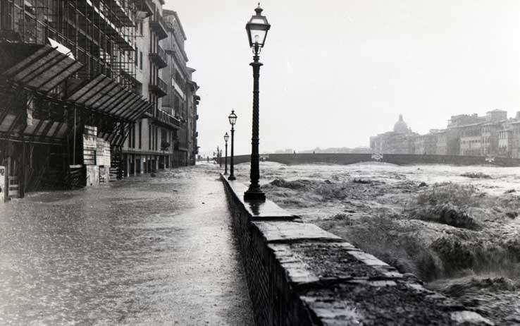


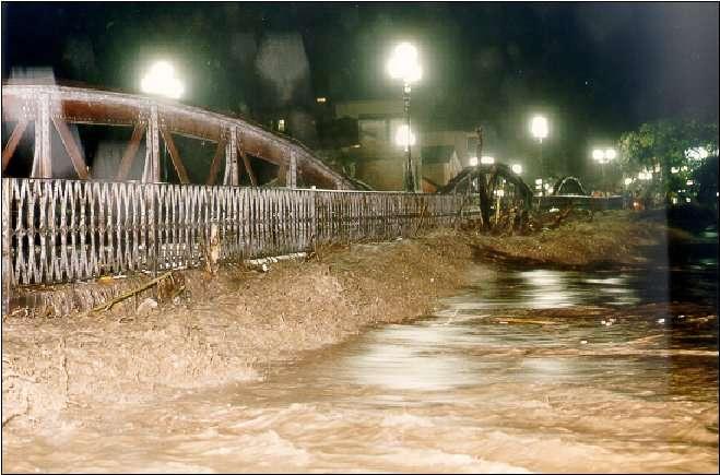

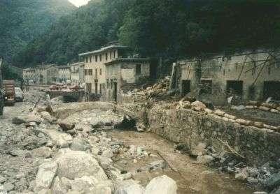
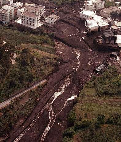


2 Italy and the management of floods SerchioVersilia, River, 2010 Firenze, Sarno, 1998 Polesine, 1951 Piemonte, 1994 Val d Aosta 2000 Sarno, Albenga, 1998 Savona, 1994 Firenze, Firenze, Valtellina, 1987 Genova, Many heavy floods have hit Italian territory


3 Firenze, For example since 1177 the Arno river has flooded Florence 56 times. 8 occurrences are defined extreme:
4 The Italian route in the mangement of floods Major disasters (1951, 1966 ) 1989 Wireframe law on soil protection 1990 Institution of RBAs 2007 Flood Directive 2007 Completion of PAI mosaic 2000 Water Directive 1998 Disaster of "Sarno" 1998 Sarno Law 1999 Preliminary mapping 1998 Start of PAI planning
5 Only one subject Planning as the main issue Basin scale A River basin authority Two time scales Flood and landslide risk Every action has to be considered and water resources within a holistic planning activity. define an unique thematic and Planning process is open to management environment institutions and Watershed is thestakeholders. planning scale, The plan isto finally approved regardless administrative by the Prime minister with both boundaries A specific Authority and has the of a State law. regional andforce state Basin planning is a components typical governs planning and deferred time scale budgeting action. Real time action is governed by Civil Protection System. Before the Flood directive : the Italian model in 5 headings

6 The RBAs (since 1989)


7 Data background: Topography Climate Geology Hydrology Hydraulics Historical records Economics Demography. The PAI Plan Analisys, definition of targets and action planning Budgeting Mapping is here Action Monitoring

8 Hazard: On 4 (sometimes 3) scenarios: From to 500 ys. return period. Hydraulic modeling and historical records. The maps Elements at risk From numerical cartography Exposure assessment for different scenarios Risk mapping into classes Scale from 1: to 1: All floodplains are mapped but the level and accuracy of information vary


9 City of Florence hazard map The case of Arno River Basin: hazard map

10 The flash flood hazard in the Arno river basin: a proposal

11 The Water directive was implemented with the D.Lgs. 152/2006 The National River Basin Authorities in earlier 2009 were responsible for coordinating and carrying out plans. The water management plans of eight districts were approved in February 2010 The district plans are built according to catchments and subunits and the information is coordinated with the hazard and risk maps of PAI The Water directive and the Flood directive
12 The flood directive was implemented with the D.Lgs. 23/2010, in February. In these days are defined the competent Authorities. Actually we believe that maps of hazard and risk of PAI meet the requirements of the Directive as preliminary flood risk assessment product to be concluded in 2011 The Water directive and the Flood directive

13 Conclusion 1 Natural risks forced by climate in Italy are managed at the basin scale The tool is the Basin Plan continuously upgraded by RBAs. Preliminary H/R maps were produced in the nineties. A state law in 1998 started a national mapping programme and is now completed. Available flood hazard maps cover all flood prone areas in Italy generally according to three/four scenarios For each scenario at least flood extent is shown on the map

14 Conclusion 2 These maps meet the requirements of the Directive as preliminary flood risk assessment product to be concluded in The review and the upgrade of maps, after a nationwide coordination work, also meets the Flood mapping product requirements deadlined for 2013 We have an important background of knowledge and experience in flood management and we can give significant contributes in this area: however, this requires strong government action in no uncertain terms to define who does what
Regulations Regarding Preliminary Flood Risk Assessment, Flood Maps and Flood Risk Management Plan
 Text consolidated by Valsts valodas centrs (State Language Centre) with amending regulations of: 20 March 2012 [shall come into force from 23 March 2012]. If a whole or part of a paragraph has been amended,
A brief introduction to the Flood (Risk) Directive. Jan Verkade, M.A. Delft Hydraulics
 Directive. Jan Verkade, M.A. Delft Hydraulics") A brief introduction to the Flood (Risk) Directive Jan Verkade, M.A. Delft Hydraulics Flood Risk Directive s full name: Directive 2007/60/EC of the European Parliament and of the Council on the assessment
A brief introduction to the Flood (Risk) Directive Jan Verkade, M.A. Delft Hydraulics Flood Risk Directive s full name: Directive 2007/60/EC of the European Parliament and of the Council on the assessment
Government Decree on Flood Risk Management 659/2010
 Ministry of Agriculture and Forestry, Finland NB: Unofficial translation; legally binding texts are those in Finnish and Swedish. Government Decree on Flood Risk Management 659/2010 Section 1 Preliminary
Directive 2007/60/EC. A new EU legal context on the assessment and management of flood risks. OJ L288, , p.27. water.europa.
 Directive 2007/60/EC A new EU legal context on the assessment and management of flood risks OJ L288, 6.11.2007, p.27 Maria Brättemark, WFD Team, DG ENV.D.1, European Commission water.europa.eu This presentation
The new European Flood Management Directive and the municipal flood management system as one realization approach
 The new European Flood Management Directive and the municipal flood management system as one realization approach, Manuela Gretzschel University of Kaiserslautern, Germany Prof. Dr. Volker Lüderitz Magdeburg
2018 PREPARING FOR A CHANGING CLIMATE AND MANAGING THE RISING FLOOD RISK
 Ireland Water 2018 PREPARING FOR A CHANGING CLIMATE AND MANAGING THE RISING FLOOD RISK Mark Adamson Office of Public Works 25 th April, 2018 FLOOD RISK IN IRELAND NATIONAL RISK ASSESSMENT, OEP 2012 & 2017
FLOOD RISK MANAGEMENT IN IRELAND
 National Flood Management Conference 2018 FLOOD RISK MANAGEMENT IN IRELAND Mark Adamson Office of Public Works 15 th March, 2018 FLOOD RISK IN IRELAND NATIONAL RISK ASSESSMENT, OEP 2012 Flooding: Joint
National Flood Risk Management Plan. CFRAM Programme
 National Flood Risk Management Plan AND THE CFRAM Programme Gerard O Connell, Engineer-in-Charge, Regional Projects & Flood Advisory Office Environmental SPC, 27 th June, 2018 HISTORIC & POLICY CONTEXT
C o p e r n i c u s E m e r g e n c y M a n a g e m e n t S e r v i c e f o r R i s k p l a n n i n g a n d R e c o v e r y
 C o p e r n i c u s E m e r g e n c y M a n a g e m e n t S e r v i c e f o r R i s k p l a n n i n g a n d R e c o v e r y Copernicus Service Copernicus EU Copernicus EU Copernicus EU www.copernicus.eu
in the EU A new EU legal context on the assessment and management of flood water.europa.eu Maria Brättemark, WFD Team, DG ENV.D.1, European Commission
 Setting the scene : Flood Risk Management in the EU A new EU legal context on the assessment and management of flood risks Maria Brättemark, WFD Team, DG ENV.D.1, European Commission water.europa.eu This
Flood risk assessment and management in Slovakia
 River Basin Management VI 61 Flood risk assessment and management in Slovakia M. Zeleňáková Institute of Building and Environmental Engineering, Technical University of Košice, Slovakia Abstract In recent
FLOOD HAZARD AND RISK MANAGEMENT UTILIZING HYDRAULIC MODELING AND GIS TECHNOLOGIES IN URBAN ENVIRONMENT
 Proceedings of the 14 th International Conference on Environmental Science and Technology Rhodes, Greece, 3-5 September 2015 FLOOD HAZARD AND RISK MANAGEMENT UTILIZING HYDRAULIC MODELING AND GIS TECHNOLOGIES
BACKGROUND When looking at hazard and loss data for future climate projections, hardly any solid information is available.
 BACKGROUND Flooding in Europe is a peak peril that has the potential to cause losses of over 14 billion in a single event. Most major towns and cities are situated next to large rivers with large amounts
STUDY VISIT TO ITALY FOR BULGARIAN LIFE PROGRAMME OFFICIALS
 Rome 26 th July 2017 STUDY VISIT TO ITALY FOR BULGARIAN LIFE PROGRAMME OFFICIALS 2 Why DERRIS? 7 millions Italians lives in areas exposed to high floods and landslides risks. In 77% cases there are homes
The 2004 Gilbert F. White National Flood Policy Forum September 21-22, 2004 FLOOD STANDARDS IN FOREIGN COUNTRIES
 The 2004 Gilbert F. White National Flood Policy Forum September 21-22, 2004 FLOOD STANDARDS IN FOREIGN COUNTRIES Firas Makarem, Dewberry, International Committee Chair, Association of State Floodplain
Flood Risk Management in Ireland. The National CFRAM Programme & overview of the Capital Works Programme. Click to add text
 Flood Risk Management in Ireland The National CFRAM Programme & overview of the Capital Works Programme Click to add text Dr. John Martin Office of Public Works Engineers Ireland's Local Government Seminar
Flood risk assessment for sustainable urban development : Case study of Marikina-Pasig-San Juan river basin, Manila
 International Conference in Urban and Regional Planning "Planning towards Sustainability and Resilience" 14 15 March, 2018 Manila, Philippines Flood risk assessment for sustainable urban development :
SOUTH CENTRAL REGION MULTI-JURISDICTION HAZARD MITIGATION PLAN. Advisory Committee Meeting September 12, 2012
 SOUTH CENTRAL REGION MULTI-JURISDICTION HAZARD MITIGATION PLAN Advisory Committee Meeting September 12, 2012 AGENDA FOR TODAY Purpose of Meeting Engage All Advisory Committee Members Distribute Project
State of South Carolina Five-Year Floodplain Management Work Plan
 Purpose The purpose of the Community Assistance Program State Support Services Element (CAP-SSSE) is to provide, through a State grant mechanism, a means to ensure that communities participating in the
Strategic Flood Risk Assessment. SFRA Report
 Strategic Flood Risk Assessment SFRA Report on Strandhill Mini-Plan Variation No.1 of the Sligo County Development Plan 2011-2017 Prepared by Contents 1. The context for the Flood Risk Assessment 1 2.
Floods Directive (2007/60/EC) : Reporting sheets Version November 2009
 : Reporting sheets Version November 2009") Floods Directive (2007/60/EC) : Reporting sheets Version November 2009 Endorsed by Water Directors 30 November 2009 1 of 19 Title:, version November 2009 Version no.: Final Date: 30 November 2009 History
Floods Directive (2007/60/EC) : Reporting sheets Version November 2009 Endorsed by Water Directors 30 November 2009 1 of 19 Title:, version November 2009 Version no.: Final Date: 30 November 2009 History
Danube Flood Risk Management Plan. Igor Liska & Raimund Mair ICPDR Secretariat
 Danube Flood Risk Management Plan Igor Liska & Raimund Mair ICPDR Secretariat 800.000 km 2 80 Mio. people 19 countries Most international River Basin in the World Danube River Protection Convention signed
Second workshop on Transboundary Flood Risk Management, Geneva, March 2015
 Second workshop on Transboundary Flood Risk Management, Geneva, 19-20 March 2015 PILOT CASE STUDY OF THE PRELIMINARY FLOOD RISK ASSESSMENT, MAPPING AND INVENTORY OF THE FLOOD RISK MANAGEMENT PLANNING FOR
Mapping flood risk its role in improving flood resilience in England
 Mapping flood risk its role in improving flood resilience in England Catherine Wright Director of Digital and Skills Flood and Coastal Risk Management Environment Agency 6 October 2017 The Environment
Planning Process---Requirement 201.6(b): An open public involvement process is essential to the development of an effective plan.
: An open public involvement process is essential to the development of an effective plan.") Section 3 Capability Identification Requirements Planning Process---Requirement 201.6(b): An open public involvement process is essential to the development of an effective plan. Documentation of the Planning
Section 3 Capability Identification Requirements Planning Process---Requirement 201.6(b): An open public involvement process is essential to the development of an effective plan. Documentation of the Planning
Torrential flood risk management in Bavaria
 Bayerisches Landesamt für Umwelt Torrential flood risk management in Bavaria Dr.-Ing. Andreas Rimböck Unit: flood protection, torrent control Torrential flood risk management in Bavaria content History
Kentucky Risk MAP It s not Map Mod II
 Kentucky Risk MAP It s not Map Mod II Risk Mapping Assessment and Planning Carey Johnson Kentucky Division of Water carey.johnson@ky.gov What is Risk MAP? Risk Mapping, Assessment, and Planning (Risk MAP)
Engineers Ireland Annual Conference
 Engineers Ireland Annual Conference MANAGING FLOOD RISK AND BUILDING SUSTAINABLE COMMUNITIES Mark Adamson Office of Public Works 15 th May, 2015 FLOOD RISK IN IRELAND RECENT FLOODS November 2009: >1,600
Questionnaire on Financial Schemes for Disaster Risk Reduction
 Questionnaire on Financial Schemes for Disaster Risk Reduction 1 Objectives of Questionnaire Survey the current financial schemes related to disaster risk reduction in each country Review current approaches
CYNGOR SIR POWYS COUNTY COUNCIL. CABINET EXECUTIVE 18 th September Flood Risk Management Plan (FRMP)
") CYNGOR SIR POWYS COUNTY COUNCIL. CABINET EXECUTIVE 18 th September 2018 REPORT AUTHOR: SUBJECT: County Councillor Phyl Davies Portfolio Holder for Highways, Recycling and Assets Flood Risk Management Plan
CYNGOR SIR POWYS COUNTY COUNCIL. CABINET EXECUTIVE 18 th September 2018 REPORT AUTHOR: SUBJECT: County Councillor Phyl Davies Portfolio Holder for Highways, Recycling and Assets Flood Risk Management Plan
IRISH FLOOD PREVENTION PROGRAMME Example of integrating climate change adaptation into projects
 IRISH FLOOD PREVENTION PROGRAMME Example of integrating climate change adaptation into projects JASPERS Networking Platform Event Climate Change Adaptation: Vulnerability and Risk Assessment and the Resilience
STATUTORY INSTRUMENTS. S.I. No. 122 of EUROPEAN COMMUNITIES (ASSESSMENT AND MANAGEMENT OF FLOOD RISKS) REGULATIONS 2010.
 REGULATIONS 2010.") STATUTORY INSTRUMENTS. S.I. No. 122 of 2010. EUROPEAN COMMUNITIES (ASSESSMENT AND MANAGEMENT OF FLOOD RISKS) REGULATIONS 2010. (Prn. A10/0432) 2 [122] S.I. No. 122 of 2010. EUROPEAN COMMUNITIES (ASSESSMENT
STATUTORY INSTRUMENTS. S.I. No. 122 of 2010. EUROPEAN COMMUNITIES (ASSESSMENT AND MANAGEMENT OF FLOOD RISKS) REGULATIONS 2010. (Prn. A10/0432) 2 [122] S.I. No. 122 of 2010. EUROPEAN COMMUNITIES (ASSESSMENT
Delaware River Basin Commission s Role in Flood Loss Reduction Efforts
 Delaware River Basin Commission s Role in Flood Loss Reduction Efforts There is a strong need to reduce flood vulnerability and damages in the Delaware River Basin. This paper presents the ongoing role
Abington Township Public Meeting
 Abington Township Public Meeting Flood Insurance Rate Map Update March 23, 2016 1 Meeting Agenda and Format Provide residents/property owners of Abington Township with information about the map update,
Floods Directive (2007/60/EC) : Reporting sheets Endorsed by Water Directors : - 30 November December 2010
 : Reporting sheets Endorsed by Water Directors : - 30 November December 2010") Floods Directive (2007/60/EC) : Reporting sheets Endorsed by Water Directors : - 30 November 2009-3 December 2010 Version 2 - February 2011 1(25) Title: Floods Directive (2007/60/EC) : Reporting sheets,
Floods Directive (2007/60/EC) : Reporting sheets Endorsed by Water Directors : - 30 November 2009-3 December 2010 Version 2 - February 2011 1(25) Title: Floods Directive (2007/60/EC) : Reporting sheets,
To protect their property
 Organization National government MSB Swedish civil contingencies agency County administrative board of Skåne Interest MSB works: via knowledge enhancement, support, training, exercises, regulation, Coordinate
FLOOD RISK MANAGEMENT PLAN DEVELOPMENT IN ROMANIA. 10th Steering Group Meeting of PA5 (Management of Environmental Risks) SUERD 29 th February 2016
 SUERD 29 th February 2016") FLOOD RISK MANAGEMENT PLAN DEVELOPMENT IN ROMANIA 10th Steering Group Meeting of PA5 (Management of Environmental Risks) SUERD 29 th February 2016 STAGE FOR IMPLEMENTATION OF THE DIRECTIVE 2007/60/EC IN
FLOOD RISK MANAGEMENT PLAN DEVELOPMENT IN ROMANIA 10th Steering Group Meeting of PA5 (Management of Environmental Risks) SUERD 29 th February 2016 STAGE FOR IMPLEMENTATION OF THE DIRECTIVE 2007/60/EC IN
REPUBLIC OF BULGARIA
 REPUBLIC OF BULGARIA DISASTER RISK REDUCTION STRATEGY INTRUDUCTION Republic of Bulgaria often has been affected by natural or man-made disasters, whose social and economic consequences cause significant
The EU Flood Action Programme Towards a fully integrated river basin management
 The EU Flood Action Programme Towards a fully integrated river basin management Helmut Blöch, European Commission Institution of Civil Engineers (ICE), London, UK DB 1 Overview Floods a transboundary European
Associated Programme on Flood Management (APFM) IFM HelpDesk Facility
 IFM HelpDesk Facility") WMO WMO World Meteorological Organization Working Working together together in in weather, weather, climate climate and and water water Associated Programme on Flood Management (APFM) IFM HelpDesk Facility
WMO WMO World Meteorological Organization Working Working together together in in weather, weather, climate climate and and water water Associated Programme on Flood Management (APFM) IFM HelpDesk Facility
IMPLEMENTING THE FLOOD DIRECTIVE IN PRUT AND SIRET
 IMPLEMENTING THE FLOOD DIRECTIVE IN PRUT AND SIRET Legal and Institutional aspects Iasi, 28-29 January, 2014 Mary-Jeanne ADLER, Scientific Director INHGA, Ministerial Consulter Timetable for adoption &
SECTION 9: MAPS AND DATA
 SECTION 9: MAPS AND DATA Contents 9.1. NFIP Maps and Data... 9-2 9.1.1. Adopting and enforcing NFIP floodplain maps and data... 9-2 9.1.2. Adopting and enforcing more restrictive data... 9-2 9.1.3. Annexations...
EIB IN THE WATER SECTOR (FLOOD PROTECTION) Hans van Os/Julio Schreier. Working Group Floods 21 March 2018
 Hans van Os/Julio Schreier. Working Group Floods 21 March 2018") EIB IN THE WATER SECTOR (FLOOD PROTECTION) European Investment Bank Hans van Os/Julio Schreier Working Group Floods 21 March 2018 European Investment Bank 1 The EIB: the EU Bank Natural financing partner
EIB IN THE WATER SECTOR (FLOOD PROTECTION) European Investment Bank Hans van Os/Julio Schreier Working Group Floods 21 March 2018 European Investment Bank 1 The EIB: the EU Bank Natural financing partner
Roadmap for future regional action in disaster risk management with focus on flood risk management and aspects with a multi-beneficiary dimension
 Grant Contract N. ECHO/SUB/2014/692292 Programme for Prevention, Preparedness and Response to Floods in the Western Balkans and Turkey IPA FLOODS IPA FLOODS implementing Consortium Italian Civil Protection
Good Practice Guide. GPG 101 Document Owner: Steve Cook. Page 1 of 7.
 Good Practice Guide Producing flood risk hydraulic models and flood consequence assessments for development planning purposes Date Published: September 2015 GPG 101 Document Owner: Steve Cook Page 1 of
Background and context of DRR and GIS
 Mainstreaming DRR into National Plan, Policies and Programmes in Nepal Present to: Regional Workshop on Geo-referenced Disaster Risk Management information System in South and South West Asia and Central
Flood Risk Management in the EU and the Floods Directive's 1 st Cycle of Implementation ( )
") COMMON IMPLEMENTATION STRATEGY FOR THE WATER FRAMEWORK DIRECTIVE AND THE FLOODS DIRECTIVE Flood Risk Management in the EU and the Floods Directive's 1 st Cycle of Implementation (2009-15) A questionnaire
COMMON IMPLEMENTATION STRATEGY FOR THE WATER FRAMEWORK DIRECTIVE AND THE FLOODS DIRECTIVE Flood Risk Management in the EU and the Floods Directive's 1 st Cycle of Implementation (2009-15) A questionnaire
Bilateral screening: Chapter 27 PRESENTATION OF THE REPUBLIC OF SERBIA
 REPUBLIC OF SERBIA Negotiating Group for the Chapter 27, Environment and Climate Change Bilateral screening: Chapter 27 PRESENTATION OF THE REPUBLIC OF SERBIA Directive 2007/60/EC of the European Parliament
The National Flood Insurance Program and Flood Insurance Rate Map for San Francisco. Presentation at Treasure Island Community Meeting
 The National Flood Insurance Program and Flood Insurance Rate Map for San Francisco Presentation at Treasure Island Community Meeting October 17, 2007 1 National Flood Insurance Program (NFIP) Overview
3D Elevation Program (3DEP) Status and Plans. Kevin T. Gallagher Associate Director, Core Science Systems June 26, 2017
 Status and Plans. Kevin T. Gallagher Associate Director, Core Science Systems June 26, 2017") + 3D Elevation Program (3DEP) Status and Plans Kevin T. Gallagher Associate Director, Core Science Systems June 26, 2017 + 2 3D Elevation Program (3DEP) Apply lidar technology to map bare earth and 3D
+ 3D Elevation Program (3DEP) Status and Plans Kevin T. Gallagher Associate Director, Core Science Systems June 26, 2017 + 2 3D Elevation Program (3DEP) Apply lidar technology to map bare earth and 3D
FOR TO THE GAELTACHT LOCAL AREA PLAN MARCH 2013
 APPENDIX II TO THE SEA ENVIRONMENTAL REPORT STAGE 2 STRATEGIC FLOOD RISK ASSESSMENT FOR PROPOSED AMENDMENT TO THE GAELTACHT LOCAL AREA PLAN 2008-2014 for: Galway County Council County Buildings Prospect
Implementing risk-based asset management strategies
 Implementing risk-based asset management strategies 2018. 04. 17 Disaster Resilience by Design The challenge for local governments The Challenge for Local Governments Landslides Debris Flows Wildfire Wind
Flood Risk Management Plan A National Pilot from the River Kokemäenjoki
 Flood Risk Management Plan A National Pilot from the River Kokemäenjoki 26-27th January 2010, Maastricht Olli-Matti Verta & Juha-Pekka Triipponen Southwest Finland Centre for Economic Development, Transport
Natural Hazards Risks in Kentucky. KAMM Regional Training
 Natural Hazards Risks in Kentucky KAMM Regional Training Floodplain 101 Kentucky has approximately 92,000 linear miles of streams and rivers Approximately 31,000 linear miles have mapped flood hazards
Flood Risk Valuation Flood Model Evaluation and Risk Pricing Evaluation
 Flood Risk Valuation Flood Model Evaluation and Risk Pricing Evaluation February 26, 2019 Joseph Becker Natural Hazards/Geosciences Group 203.229.8832 joseph.f.becker@guycarp.com GUY CARPENTER Macro forces
LOCAL OFFICIALS MEETING Lake Wausau Physical Map Revision MARATHON COUNTY, WISCONSIN FEBRUARY 9, 2017
 LOCAL OFFICIALS MEETING Lake Wausau Physical Map Revision MARATHON COUNTY, WISCONSIN FEBRUARY 9, 2017 Welcome & Introduction Michelle Staff Floodplain Management Policy Coordinator, WDNR Michelle.Staff@Wisconsin.gov
Dealing With Unnumbered A Zones in Maine Floodplain Management
 Dealing With Unnumbered A Zones in Maine Floodplain Management The following is a list of acceptable methods that the State Floodplain Management Coordinator and the Federal Emergency Management Agency
DEFINING BEST PRACTICE IN FLOODPLAIN MANAGEMENT
 DEFINING BEST PRACTICE IN FLOODPLAIN MANAGEMENT M Babister 1 M Retallick 1 1 WMAwater, Level 2,160 Clarence Street Sydney Abstract With the upcoming release of the national best practice manual, Managing
3DEP Coalition Meeting. Kevin T. Gallagher Associate Director, Core Science Systems November 10, 2016
 + 3DEP Coalition Meeting Kevin T. Gallagher Associate Director, Core Science Systems November 10, 2016 + 2 3DEP Status 2023 + 3 3D Elevation Program (3DEP) Mission Critical Applications Geologic Hazards
KÁROLY GOMBÁS CHAIRMAN, NATIONAL DELEGATE FLOOD PROTECTION EXPERT GROUP (FP-EG) INTERNATONAL COMISSION FOR THE PROTECTION OF THE DANUBE RIVER
 INTERNATONAL COMISSION FOR THE PROTECTION OF THE DANUBE RIVER") Flood Risk Management Plan for the Danube Basin Second Stakeholder Seminar EU Strategy for the Danube Region 19th - 20th November 2015 Budapest, Hungary KÁROLY GOMBÁS CHAIRMAN, NATIONAL DELEGATE FLOOD
Flood Risk Management Plan for the Danube Basin Second Stakeholder Seminar EU Strategy for the Danube Region 19th - 20th November 2015 Budapest, Hungary KÁROLY GOMBÁS CHAIRMAN, NATIONAL DELEGATE FLOOD
2017 EFDRR Open Forum Istanbul, Turkey March Concept Note of Technical Session. Monday, 27 March 2017, 16:00 18:00 hrs
 FINAL 2017 EFDRR Open Forum Istanbul, Turkey 26-28 March 2017 Concept Note of Technical Session Event title Technical Session 4: Risk Assessment and Disaster Loss Database in support of monitoring of the
Flood Hazards and Flood Risk, the Impact of a Changing Climate
 Flood Hazards and Flood Risk, the Impact of a Changing Climate Sally A. McConkey, P.E. CFM, D. WRE. Illinois State Water Survey June 14, 2017 Topics ISWS Coordinated Hazard Assessment and Mapping Program
Objectives of this Briefing
 Eastern CFRAM Study (Catchment Flood Risk Assessment & Management) Stakeholders Briefing Poddle & Camac Watercourses Overview Grace Glasgow July 2013 Burns Beach near Brighton, Western Australia RPS has
FEMA s Flood Map Modernization Preparing for FY09 and Beyond: Integrated Flood Data Update, Risk Assessment, and Mitigation Planning
 FEMA s Flood Map Modernization Preparing for FY09 and Beyond: Integrated Flood Data Update, Risk Assessment, and Mitigation Planning DRAFT CONCEPT PAPER June 1, 2007 Integrated Flood Data Update, Risk
Implementation of the Flood Directive in Romania
 Implementation of the Flood Directive in Romania Daniela RĂDULESCU, Bogdan ION EUROPE-INBO 2015 13 th INTERNATIONAL CONFERENCE FOR THE IMPLEMENTATION OF THE EUROPEAN WATER DIRECTIVES PROVISIONS AND DEADLINES
A Modernized Conservation Authorities Act and Flood Management in Ontario: Building on Successes
 A Modernized Conservation Authorities Act and Flood Management in Ontario: Building on Successes Water Resources Section Natural Resources Conservation Policy Branch Policy Division March 6, 2018 Overview
Improved tools for river flood preparedness under changing risk - Poland
 7th Study Conference on BALTEX, Borgholm, Sweden, 10-14 June 2013 Improved tools for river flood preparedness under changing risk - Poland Zbigniew W. Kundzewicz Institute of Agricultural and Forest Environment,
Flood Solutions. Summer 2018
 Flood Solutions Summer 2018 Flood Solutions g Summer 2018 Table of Contents Flood for Lending Life of Loan Flood Determination... 2 Multiple Structure Indicator... 2 Future Flood... 2 Natural Hazard Risk...
Working with natural processes to help manage flood risk natural flood management Dr. Heather Forbes. Scottish Environment Protection Agency
 Working with natural processes to help manage flood risk natural flood management Dr. Heather Forbes Senior Policy Officer Programme Scottish Environment Protection Agency Scotland s flood risk 56% 21%
EUROPEAN DIRECTIVE FLOODS 2007/60/EC AND RIVER BASIN PLANNING
 EUROPEAN DIRECTIVE FLOODS 2007/60/EC AND RIVER BASIN PLANNING Fare clic per modificare lo stile del sottotitolo dello schema Ing. Giorgio Cesari General Secretary of Tevere river basin Authority TEVERE
NFIP Program Basics. KAMM Regional Training
 NFIP Program Basics KAMM Regional Training Floodplain 101 Homeowners insurance does not cover flood damage Approximately 25,000 flood insurance policies in KY According to BW12 analysis, approximately
FREQUENTLY ASKED QUESTION ABOUT FLOODPLAINS Michigan Department of Environmental Quality
 FREQUENTLY ASKED QUESTION ABOUT FLOODPLAINS Michigan Department of Environmental Quality WHAT IS A FLOOD? The National Flood Insurance Program defines a flood as a general and temporary condition of partial
Damages caused by Flash Floods
 Damages caused by Flash Floods Damages caused as a result of flash flood are enormous both on human lives and loss of property. It is reported that flood disasters account for about a third of all natural
NEWS RELEASE. All levels of government support 30 British Columbia flood mitigation projects
 For Immediate Release 2018PSSG0005-000150 Feb. 2, 2018 NEWS RELEASE Ministry of Public Safety and Solicitor General Emergency Management BC Public Safety Canada All levels of government support 30 British
The AIR Inland Flood Model for the United States
 The AIR Inland Flood Model for the United States In Spring 2011, heavy rainfall and snowmelt produced massive flooding along the Mississippi River, inundating huge swaths of land across seven states. As
Suwannee River Water Management District
 Suwannee River Water Management District FEMA Flood Map Modernization Program 5-Year Business Plan FY 2004-2009 Prepared By: URS Corporation Dewberry Water Resource Associates February 14, 2004 Revised
Republic of Mauritius. Official Statement for 2017 Global Platform. For Disaster Risk Reduction
 Republic of Mauritius Official Statement for 2017 Global Platform For Disaster Risk Reduction Your Excellency the Prime Minister of the United Mexican States Your Excellency the Secretary General of the
Federal Flood Risk Management Standards. An Update on Federal Flood Resilience Standards
 Federal Flood Risk Management Standards An Update on Federal Flood Resilience Standards Purpose of Today s Briefing Facilitate the understanding of Executive Order (E.O.)13690 and its implementation Discuss
Association of State FloodPlain Managers 2809 Fish Hatchery Road, Madison, WI Phone: Fax:
 Association of State FloodPlain Managers 2809 Fish Hatchery Road, Madison, WI 53713 Phone: 608-274-0123 Fax: 274-0696 Website: www.floods.org Email: asfpm@floods.org Conference Call: FEMA-Washington and
7. Understand effect of multiple annual exposures e.g., 30-yr period and multiple independent locations yr event over 30 years 3%
 I. FLOOD HAZARD A. Definition 1. Hazard: probability of water height 2. At a Specific XY floodplain location; 3. Z can be expressed as elevation (NAVD88); gauge height; height above ground (depth). 4.
Proposal for a DECISION OF THE EUROPEAN PARLIAMENT AND OF THE COUNCIL. on the mobilisation of the EU Solidarity Fund
 EUROPEAN COMMISSION Brussels, 23.7.2015 COM (2015) 370 final Proposal for a DECISION OF THE EUROPEAN PARLIAMENT AND OF THE COUNCIL on the mobilisation of the EU Solidarity Fund EN EN INFORMATION AND CONDITIONS
Natural Hazards Risk Mapping in Sweden ISDR
 Natural Hazards Risk Mapping in Sweden ISDR Barbro Näslund-Landenmark Ecologist, Senior advisor Swedish Rescue Services Agency Department of emergency prevention Section for environment, planning and building
Taylor County, Florida Community Coordination and Outreach (CCO) Meeting
 Meeting") Taylor County, Florida Community Coordination and Outreach (CCO) Meeting Suwannee River Water Management District April 26, 2017 11:00AM to 12:00PM Taylor County Administration Building, 201 E. Green Street,
Taylor County, Florida Community Coordination and Outreach (CCO) Meeting Suwannee River Water Management District April 26, 2017 11:00AM to 12:00PM Taylor County Administration Building, 201 E. Green Street,
Enough about me! Topics Covered
 About Me Worked in land surveying since 1997 Employed by the City of Orlando since 2006 City of Orlando City Surveyor since February 2015 Certified Floodplain Manager since 2015 Florida Licensed Surveyor,
Flood Risk, Insurance and Integrated Flood Hazard Management
 Canadian Water Resources Association Association Canadienne des Ressources Hydriques Flood Risk, Insurance and Integrated Flood Hazard Management Dave Murray, National President June 8-9, 2016 Window on
Federal Floodplain Mapping Guideline Series. CRHNet 2017 Symposium Halifax, Nova Scotia October 25, 2017
 Federal Floodplain Mapping Guideline Series CRHNet 2017 Symposium Halifax, Nova Scotia October 25, 2017 Overview 1. Introduction to Floodplain Maps 2. Federal Floodplain Mapping Guidelines Series 3. Stakeholder
BUTTS COUNTY, GEORGIA AND INCORPORATED AREAS
 BUTTS COUNTY, GEORGIA AND INCORPORATED AREAS Butts County Community Name Community Number BUTTS COUNTY (UNICORPORATED AREAS) 130518 FLOVILLA, CITY OF 130283 JACKSON, CITY OF 130222 JENKINSBURG, TOWN OF
The Hydro-illogical Cycle
 The Hydro-illogical Cycle and the case for Integrated Flood Hazard Management Dave Murray, P.Eng., CWRA National President Canadian Water Resources Association Association Canadienne des Ressources Hydriques
Strategic Flood Risk Management
 Strategic Management Duncan McLuckie (NSW Department of Infrastructure and Natural Resources) Introduction This paper discusses what is meant by strategic flood risk management, who is responsible in New
Czech Republic. National progress report on the implementation of the Hyogo Framework for Action ( )
") Czech Republic National progress report on the implementation of the Hyogo Framework for Action (2011-2013) Name of focal point: Organization: Title/Position: E-mail address: Marie Adamkova/Matyas Doul
Czech Republic National progress report on the implementation of the Hyogo Framework for Action (2011-2013) Name of focal point: Organization: Title/Position: E-mail address: Marie Adamkova/Matyas Doul
17. Reduction. 17 REDUCTION p1
 17. Reduction Summary Reduction involves identifying and analysing risks to life and property from hazards, taking steps to eliminate those risks if practicable, and, if not, reducing the magnitude of
Flood Hazard Maps: An Update
 Flood Hazard Maps: An Update Ir BIBI ZARINA BINTI CHE OMAR JABATAN PENGAIRAN DAN SALIRAN MALAYSIA 9 Jun 2014 Introduction INTRODUCTION Flooding is a natural phenomenon and has been occurring for millions
A REALITY CHECK ON FLOOD RISK
 A REALITY CHECK ON FLOOD RISK Barry Carter, Nick Brown, Neil Blazey. Auckland Council, Auckland, New Zealand. ABSTRACT Traditional approaches to flood risk assessments involve modelling catchment systems
Riverine Flooding - Cedar Rapids, Iowa 2008
 Katrina 2005 Riverine Flooding - Cedar Rapids, Iowa 2008 Riverine and Pluvial Flooding Nashville 2010 Mississippi and Missouri Rivers 2011 INFRASTRUCTURE ECONOMY 21 st Century 20 th Century "Toto, I've
in coordination with Peoria County, Planning and Zoning Department
 Prepared by Amec Foster Wheeler Environment & Infrastructure Hazard Mitigation and Emergency Management Program in coordination with Peoria County, Planning and Zoning Department The purpose of hazard
Flood risk management plans the interlink between Floods Directive and Water Framework Directive a creative approach to authorities work
 Flood risk management plans the interlink between Floods Directive and Water Framework Directive a creative approach to authorities work Gimo, 11.06.2014 Iveta Teibe, iveta.teibe@varam.gov.lv What s explicitly
Disaster Risk Reduction and Management in St. Lucia
 Disaster Risk Reduction and Management in St. Lucia National Circumstances Saint Lucia is a Small Island Developing State (SIDS) located at latitude 13 o N, and 61 o S within the Lesser Antilles. The
Passaic River Basin Flood Advisory Commission Report/Status of Recommendations. October 2014 Update
 Passaic River Basin Flood Advisory Commission Report/Status of Recommendations October 2014 Update Passaic River Basin Flood Advisory Commission April 2010: By Executive Order, Governor Christie created
Mapping Flood Risk in the Upper Fox River Basin:
 Mapping Flood Risk in the Upper Fox River Basin: Vulnerable Populations and Adverse Health Effects Presented by: Angelina Hanson STUDY AREA: Wisconsin's Upper Fox River Basin Total Population 139,309.
Multi-Jurisdictional. Multnomah County. Natural Hazards Mitigation Plan. Public Comment DRAFT Nov. 7, 2016
 Multnomah County Multi-Jurisdictional Natural Hazards Mitigation Plan Participating Jurisdictions: Multnomah County City of Fairview City of Gresham City of Troutdale City of Wood Village Public Comment