PLANNING FOR SAFE AND SUSTAINABLE COMMUNITIES
|
|
|
- Gordon Gilmore
- 6 years ago
- Views:
Transcription

1 Flood Risk Management Protecting and Planning for our Communities PLANNING FOR SAFE AND SUSTAINABLE COMMUNITIES Mark Adamson Office of Public Works 12 th February, 2014
2 A WET START TO THE YEAR!
3 STORM CHRISTINE NEW YEAR THE PERFECT STORM Coincidence of: Highest Astronomical Tides Severe Depression -> Significant Storm Surge Very High Winds -> Significant Wave Set-Up Storm Damage & Erosion e.g., Lahinch Flooding: Extreme Sea Levels e.g., Galway City, Shannon Estuary, Cork, Dublin, Dundalk Wave Action e.g., Lahinch, Salthill, Tramore Significant Damage to Infrastructure
4 STORM BRIGID 1 st FEB ANOTHER ONE! Similar Coincidence of Events H.A.T. Conditions, Extreme Surge, Gale-Force Winds Westerly Winds -> Surge up the Shannon Estuary Limerick & Shannon Estuary Highest water levels in >80yrs Appx. 200mm higher than October 1961 Mainly Affected Areas around Kings Island & St. Mary s Park (300 Properties) Area Targeted for Re-Generation Decisions to be made! Affected Other Areas on West Coast
5 STORM BRIGID II 3/4 th FEB A THIRD!!! Same Story Again! H.A.T. Conditions, Extreme Surge, Gale-Force Winds Southerly Winds -> South / South East Coast Cork City: 3 rd Feb, a.m. & 4 th Feb, p.m. Levels Marginally Lower than 2004 Tidal Event Estimated 150 Business Properties Flooded South Coast Youghal, Passage East, Wexford, New Ross,
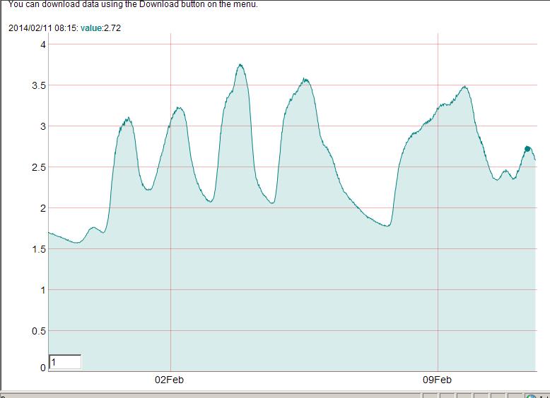
6 INLAND FLOODING PROLONGED PERIOD OF HEAVY RAINFALL January: Above Average Everywhere: 122% 183% Monthly Average Wet Days in the Month across the Country Wettest January in 5 21 Years February So Far: Conveyor Belt of Atlantic Storms Series of Days of Heavy Rainfall HIGH RIVER LEVELS

7 INLAND FLOODING

8 INLAND FLOODING

9 INLAND FLOODING
10 INLAND FLOODING PROLONGED PERIOD OF HEAVY RAINFALL January: Above Average Everywhere: 122% 183% Monthly Average Wet Days in the Month across the Country Wettest January in 5 21 Years February So Far: Conveyor Belt of Atlantic Storms Series of Days of Heavy Rainfall HIGH RIVER LEVELS Shannon Remains High since before New Year More Recently: West, South-West and South-East Limited Flooding of Communities
11 SO WHAT HAS THE REACTION BEEN?
12 AFFECTED PEOPLE RESIDENTS & BUSINESS OWNERS Many Un-Prepared Many Un-Insured HELP! HUMANITARIAN ASSISTANCE PROGRAMME 10m (Storm Christine ) + 15m (Storm Bridgid ) Managed by Dept. Social Protection
13 AFFECTED PEOPLE BUT SOME WERE PREPARED Cork City Floods: We know what to do We were back in business 2 hours later Business Owner (3 rd Feb) Many Businesses Open again by Lunch-time or in the Afternoon RTE (5 th Feb) Not Possible for All (e.g., Catering) Resilience can Reduce Impact & Damages Need to Build Further Awareness, Preparedness & Resilience in our Communities
14 COUNCILS PRAISED FOR RECOVERY EFFORT PRAISED FOR PREPARATORY EFFORT Particularly so for 4 th Feb Opportunity for Review of Flood Event Emergency Response Plans REQUIRE FUNDING ASSISTANCE Govt. Committed 70m Fund for Repairs ONGOING NEED TO FOCUS ON SUSTAINABLE PLANNING
15 PLANNING MAJOR CRITICISM AFTER NOV 09 EVENT NOW REFERRED TO AGAIN Has to be a lot more advance planning (some local authorities) need to do more Ciaran Cuffe, RTE, 4 th Feb Greater Focus Required on Coastal Areas Lot of Work Required to Solve Existing Problems Let s Not Create New Ones!
16 CLIMATE CHANGE REFERRED TO FREQUENTLY We re Going to See a Wetter Irish Climate We ve Got to Plan for That Ciaran Cuffe, RTE, 4 th Feb WAS CLIMATE CHANGE TO BLAME? MSL Rise of 200mm over Last Century Current Rate of Rise 3.2mm/yr Contributory Factor, But Not Sole Cause However Need to Consider What Future Changes Might Be, and Plan to Adapt / Provide for Change
17 GET ON WITH IT! PUBLIC FRUSTRATION WITH DELAYS Totally Understandable! BUT Challenging Construction Projects: Up to 40m Civils Projects in City / Town Centres on Public and Private Lands Legal Requirements: Procurement, Consultation, Environmental Assessment, Planning / Public Exhibition,. Complex Design Process: Modelling complex natural systems, often under uncertainty Need to be Sure It s the Right Project - Rushed Job can be a Bad Job!
18 SO. WHAT ARE WE DOING? (AND WHEN?)


19 PLAN, PREPARE, PROTECT LAUNCHED 2006

20 FLOODMAPS.IE LAUNCHED 2006


21 GUIDANCE ON EMERGENCY PLANS PREPARED 2008 UPDATED

22 SURGE ADVISORY SERVICE TESTING BEGAN 2009

23 EFAS BECAME MEMBERS 2010
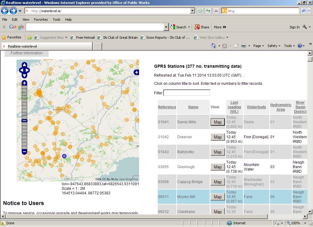
24 WATERLEVEL.IE LAUNCHED 2013
25 WHAT ARE WE DOING? STRATEGIC FFWS REVIEW Completed Recommends National FFS Centre Recommendations under Consideration FSU Research Completed Portal to be Launched 2014 CAPITAL PROGRAMME Minor Works: 29m Approved for 430 Projects since 2009 Appx. 2,500 Properties Protected Major Schemes: 32 Schemes Completed Appx. 8,000 Properties Protected 8 Schemes In Construction & 23 Schemes In Design / Planning
26 CFRAM PROGRAMME NATIONAL CFRAM PROGRAMME Catchment-Based Flood Risk Assessment and Management (CFRAM) Studies Key Outputs Flood Maps Catchment Flood Risk Management Plan
27 CFRAM PROGRAMME SCOPE OF WORK Survey Data Collection Hydrology Hydraulics / Flood Mapping
28
29
30 CFRAM PROGRAMME SCOPE OF WORK Survey Data Collection Hydrology Hydraulics / Flood Mapping Incl. Future Scenarios Risk Analysis Flood Risk Management Options Outline Design SEA / Appropriate (Habitats) Assessment Flood Risk Management Plan

31 CFRAM PROGRAMME FLOOD MAPS AFAs, Incl 90 Coastal Communities - 2,500 kms Other Mapped River - Inform: - Sustainable Planning - Emergency Response Planning - Public Awareness & Preparedness - Public Consultation Summer 2014 FRMPs - Outline Scheme / Measure Design: AFAs, Incl 90 Coastal Communities - Potentially > bn Works - Benefit to IE: At least 30m Per Year - Public Consultation 2015
 Consideration of Range of Benefits MCA Benefit Cost Ratio Economic Benefit Cost Ratio What for Low Priority or Other Areas?")
32 CFRAM PROGRAMME BUDGETS & PRIORITISATION OPW Current Annual Capital FRM Budget: 45m FRMP Recommendations: Potentially > bn Need to Prioritise Major Capital Investments: CFRAM Multi-Criteria Analysis (MCA) Consideration of Range of Benefits MCA Benefit Cost Ratio Economic Benefit Cost Ratio What for Low Priority or Other Areas? Minor-Works Non-Structural Measures FFWS, FERP, AP&R

33 PLANNING GUIDELINES OPW DoECLG INITIATIVE LAUNCHED: NOVEMBER 2009 BENEFITS OF SUSTAINABLE PLANNING Major Component of Flood Risk Prevention Avoids Creation of New Risks Avoids Additional Future Demands for Resources Essential for Long-Term, Sustainable Flood Risk Management
34 MULTI-FACETED OR HOLISTIC FLOOD RISK MANAGEMENT PREVENT Sustainable Planning and Development Management PROTECT Major & Minor Flood Relief Schemes PREPARE Effective Flood Forecasting & Warning Effective, Targeted Flood Event Response Plans Plan, Prepare, Protect Take to Local Level People Aware, Prepared and Resilient
35 NEED ALL THREE FOR SAFE, SUSTAINABLE COMMUNITIES
36 Flood Risk Management Protecting and Planning for our Communities PLANNING FOR SAFE AND SUSTAINABLE COMMUNITIES Mark Adamson Office of Public Works 12 th February, 2014
37
Engineers Ireland Annual Conference
 Engineers Ireland Annual Conference MANAGING FLOOD RISK AND BUILDING SUSTAINABLE COMMUNITIES Mark Adamson Office of Public Works 15 th May, 2015 FLOOD RISK IN IRELAND RECENT FLOODS November 2009: >1,600
2018 PREPARING FOR A CHANGING CLIMATE AND MANAGING THE RISING FLOOD RISK
 Ireland Water 2018 PREPARING FOR A CHANGING CLIMATE AND MANAGING THE RISING FLOOD RISK Mark Adamson Office of Public Works 25 th April, 2018 FLOOD RISK IN IRELAND NATIONAL RISK ASSESSMENT, OEP 2012 & 2017
Flood Risk Management in Ireland. The National CFRAM Programme & overview of the Capital Works Programme. Click to add text
 Flood Risk Management in Ireland The National CFRAM Programme & overview of the Capital Works Programme Click to add text Dr. John Martin Office of Public Works Engineers Ireland's Local Government Seminar
FLOOD RISK MANAGEMENT IN IRELAND
 National Flood Management Conference 2018 FLOOD RISK MANAGEMENT IN IRELAND Mark Adamson Office of Public Works 15 th March, 2018 FLOOD RISK IN IRELAND NATIONAL RISK ASSESSMENT, OEP 2012 Flooding: Joint
IRISH FLOOD PREVENTION PROGRAMME Example of integrating climate change adaptation into projects
 IRISH FLOOD PREVENTION PROGRAMME Example of integrating climate change adaptation into projects JASPERS Networking Platform Event Climate Change Adaptation: Vulnerability and Risk Assessment and the Resilience
National Flood Risk Management Plan. CFRAM Programme
 National Flood Risk Management Plan AND THE CFRAM Programme Gerard O Connell, Engineer-in-Charge, Regional Projects & Flood Advisory Office Environmental SPC, 27 th June, 2018 HISTORIC & POLICY CONTEXT
CLIMATE CHANGE SECTORAL ADAPTATION PLAN FLOOD RISK MANAGEMENT
 CLIMATE CHANGE SECTORAL ADAPTATION PLAN FLOOD RISK MANAGEMENT (2015-2019) 2538_RP/002/E FRAM Section Office of Public Works PROJECT Climate Change Adaptation Plan PROJECT No. 2538 PROJECT ENGINEER: CLIENT:
DRAFT APPROPRIATE ASSESSMENT SCREENING REPORT
 DRAFT APPROPRIATE ASSESSMENT SCREENING REPORT Climate Change Sectoral Adaptation Plan for Flood Risk Management (2014-2019) 2538_RP/003/C FRAM Section Office of Public Works 2538_RP/003/D CONTENTS 1.0
Shannon Flood Risk State Agency Co-ordination Working Group - Open Days on Work Programme
 Shannon Flood Risk State Agency Co-ordination Working Group - Open Days on Work Programme Questions and Answers What is the purpose of the Shannon Flood Risk State Agency Co-ordination Working Group? The
Lower Lee (Cork City) Flood Relief Scheme (Including Blackpool and Ballyvolane)
 Flood Relief Scheme (Including Blackpool and Ballyvolane)") STUDY AREA MAP N LEGEND: Study Area (for which flood alleviation measures are to be identified) Additional Environmental Study Area (assessment area of environmental affects from proposed flood alleviation
STUDY AREA MAP N LEGEND: Study Area (for which flood alleviation measures are to be identified) Additional Environmental Study Area (assessment area of environmental affects from proposed flood alleviation
DRAFT STRATEGIC ENVIRONMENTAL ASSESSMENT SCREENING REPORT. Climate Change Sectoral Adaptation Plan for Flood Risk Management ( )
") Office of Public Works DRAFT STRATEGIC ENVIRONMENTAL ASSESSMENT SCREENING REPORT Climate Change Sectoral Adaptation Plan for Flood Risk Management (2014-2019) Determination of the need for strategic environmental
Office of Public Works DRAFT STRATEGIC ENVIRONMENTAL ASSESSMENT SCREENING REPORT Climate Change Sectoral Adaptation Plan for Flood Risk Management (2014-2019) Determination of the need for strategic environmental
THE EU FLOODS DIRECTIVE:
 Sixth Bulgarian Austrian Seminar THE EU FLOODS DIRECTIVE: EUROPEAN PRACTICE AND RESEARCH IN FLOOD RISK MANAGEMENT Mark Adamson Co-Chair, Working Group F Office of Public Works, IE 7 th November, 2013 PRESENTATION
LOCAL FLOOD RISK STRATEGY EMYR WILLIAMS PEMBROKESHIRE COUNTY COUNCIL
 LOCAL FLOOD RISK STRATEGY EMYR WILLIAMS PEMBROKESHIRE COUNTY COUNCIL Flood Risk Management We can only manage flood risk. It is not possible to prevent all flooding even if we had the money. There will
Comptroller and Auditor General Special Report. Strategic Planning for Flood Risk Management
 Comptroller and Auditor General Special Report Strategic Planning for Flood Risk Management Report number 92 December 2015 2 Strategic Planning for Flood Risk Management Report of the Comptroller and Auditor
Planning and Flood Risk
 Planning and Flood Risk Patricia Calleary BE MEngSc MSc CEng MIEI After the Beast from the East Patricia Calleary Flood Risk and Planning Flooding in Ireland» Floods are a natural and inevitable part of
Interim Report to Government. Interdepartmental Flood Policy Co-ordination Group. 8 November 2016.
 Interim Report to Government Interdepartmental Flood Policy Co-ordination Group 8 November 2016. Table of Contents INTRODUCTION... 3 ABBREVIATIONS... 5 EXECUTIVE SUMMARY... 7 1. GOVERNMENT S FLOOD RISK
Acknowledgements. Legal Disclaimer. Copyright
 SUMMARY REPORT 2018 Acknowledgements The Office of Public Works (OPW) gratefully acknowledges the assistance, input and provision of data by a large number of organisations towards the implementation
Broad-Scale Assessment of Urban Flood Risk Mark G. E. Adamson 1
 Broad-Scale Assessment of Urban Flood Risk Mark G. E. Adamson 1 1 Office of Public Works, Trim, Co. Meath, Ireland Abstract The Directive on the assessment and management of flood risks (2007/60/EC The
Flood Risk Management Business Plan 2013
 Flood Risk Management Business Plan 2013 SECTION 1: OVERVIEW Vision To minimise the impacts of flooding on society, households and businesses, through sustainable planning, guidance, information and effective
What can be done to minimise future economic and social harm caused by flooding and improve resilience. Flood Warning and Informing
 What can be done to minimise future economic and social harm caused by flooding and improve resilience Flood Warning and Informing Marc Becker SEPA Flood Risk Manager (Hydrology) 16 th September 2016 The
FOR TO THE GAELTACHT LOCAL AREA PLAN MARCH 2013
 APPENDIX II TO THE SEA ENVIRONMENTAL REPORT STAGE 2 STRATEGIC FLOOD RISK ASSESSMENT FOR PROPOSED AMENDMENT TO THE GAELTACHT LOCAL AREA PLAN 2008-2014 for: Galway County Council County Buildings Prospect
Comhairle Baile Cheanntair~ Nás na Ríogh
 Comhairle Baile Cheanntair~ Nás na Ríogh DRAFT STRATEGIC FLOOD RISK ASSESSMENT NAAS TOWN DEVELOPMENT PLAN 2011 ~ 2017 Kildare County Council Water Services Department Aras Chill Dara Devoy Park Naas County
Climate Change Adaptation Plan for Choiseul Bay Township, Solomon Islands
 Climate Change Adaptation Plan for Choiseul Bay Township, Solomon Islands Dr Philip Haines and Ms Shannon McGuire Sustainable Engineering Society - Technical Session 17 March 2015 1 Presentation outline
Strategic Flood Risk Assessment. SFRA Report
 Strategic Flood Risk Assessment SFRA Report on Strandhill Mini-Plan Variation No.1 of the Sligo County Development Plan 2011-2017 Prepared by Contents 1. The context for the Flood Risk Assessment 1 2.
Strategic Flood Risk Assessment Report. Ireland 2040 Our Plan Draft National Planning Framework
 Strategic Flood Risk Assessment Report Ireland 2040 Our Plan Draft National Planning Framework TABLE OF CONTENTS 1 INTRODUCTION... 1 1.1 OBJECTIVE... 1 1.2 SFRA INTEGRATION WITH THE DRAFT NPF... 1 1.3
DOCUMENT CONTROL SHEET
 Final Report Unit of Management 08 DOCUMENT CONTROL SHEET Client Project Title Document Title Document No. This Document Comprises The OPW IBE0600Rp0079 F02 IBE0600Rp0079 DCS TOC Text List of Tables List
Isle of Arran (Potentially Vulnerable Area 12/08) Local Plan District Local authority Main catchment Brodick to Kilmory Ayrshire North Ayrshire Counci
 Local Plan District Local authority Main catchment Brodick to Kilmory Ayrshire North Ayrshire Counci") Isle of Arran (Potentially Vulnerable Area 12/08) Local Plan District Ayrshire Local authority North Ayrshire Council Main catchment Brodick to Kilmory Arran coastal Summary of flooding impacts At risk
Isle of Arran (Potentially Vulnerable Area 12/08) Local Plan District Ayrshire Local authority North Ayrshire Council Main catchment Brodick to Kilmory Arran coastal Summary of flooding impacts At risk
Flood Risk Management Plan for the BALLYTEIGUE BANNOW River Basin (UoM13)
") Appropriate Assessment Determination in accordance with Regulation 42(11) of the European Communities (Birds and Natural Habitats) Regulations 2011 2015 Flood Risk Management Plan for the BALLYTEIGUE BANNOW
Appropriate Assessment Determination in accordance with Regulation 42(11) of the European Communities (Birds and Natural Habitats) Regulations 2011 2015 Flood Risk Management Plan for the BALLYTEIGUE BANNOW
Objectives of this Briefing
 Eastern CFRAM Study (Catchment Flood Risk Assessment & Management) Stakeholders Briefing Poddle & Camac Watercourses Overview Grace Glasgow July 2013 Burns Beach near Brighton, Western Australia RPS has
Glasgow City centre (Potentially Vulnerable Area 11/16) Local Plan District Local authority Main catchment Clyde and Loch Lomond Glasgow City Council
 Local Plan District Local authority Main catchment Clyde and Loch Lomond Glasgow City Council") Glasgow City centre (Potentially Vulnerable Area 11/16) Local Plan District Clyde and Loch Lomond Local authority Glasgow City Council Main catchment River Clyde Summary of flooding impacts At risk of
Glasgow City centre (Potentially Vulnerable Area 11/16) Local Plan District Clyde and Loch Lomond Local authority Glasgow City Council Main catchment River Clyde Summary of flooding impacts At risk of
Kirkwall (Potentially Vulnerable Area 03/05) Local Plan District Local authority Main catchment Orkney Orkney Islands Council Orkney coastal Backgroun
 Local Plan District Local authority Main catchment Orkney Orkney Islands Council Orkney coastal Backgroun") Kirkwall (Potentially Vulnerable Area 03/05) Local Plan District Orkney Local authority Orkney Islands Council Main catchment Orkney coastal Summary of flooding impacts 490 residential properties 460 non-residential
Kirkwall (Potentially Vulnerable Area 03/05) Local Plan District Orkney Local authority Orkney Islands Council Main catchment Orkney coastal Summary of flooding impacts 490 residential properties 460 non-residential
Flood Risk Management Plan for the NORTH WESTERN River Basin (UoM01)
") Appropriate Assessment Determination in accordance with Regulation 42(11) of the European Communities (Birds and Natural Habitats) Regulations 2011 2015 Flood Risk Management Plan for the NORTH WESTERN
Appropriate Assessment Determination in accordance with Regulation 42(11) of the European Communities (Birds and Natural Habitats) Regulations 2011 2015 Flood Risk Management Plan for the NORTH WESTERN
Solway Local Plan District 1 Flood risk management in Scotland 1.1 What is a Flood Risk Management Strategy? Flood Risk Management Strategies have bee
 Flood Risk Management Strategy Solway Local Plan District Section 1: Flood Risk Management in Scotland 1.1 What is a Flood Risk Management Strategy?... 1 1.2 How to read this Strategy... 1 1.3 Managing
East Meath Local Area Plan
 East Meath Local Area Plan 2014-2020 Bettystown / Laytown / Mornington East / Donacarney / Mornington Volume 3 Appendix C Strategic Flood Risk Assessment Copyright JBA Consulting Engineers and Scientists
Clyde south - Port Glasgow to Inchinnan (Potentially Vulnerable Area 11/09) Local Plan District Clyde and Loch Lomond Local authority Inverclyde Counc
 Local Plan District Clyde and Loch Lomond Local authority Inverclyde Counc") Clyde south - Port Glasgow to Inchinnan (Potentially Vulnerable Area 11/09) Local Plan District Clyde and Loch Lomond Local authority Inverclyde Council, Renfrewshire Council Main catchment Firth of Clyde
Clyde south - Port Glasgow to Inchinnan (Potentially Vulnerable Area 11/09) Local Plan District Clyde and Loch Lomond Local authority Inverclyde Council, Renfrewshire Council Main catchment Firth of Clyde
Mapping flood risk its role in improving flood resilience in England
 Mapping flood risk its role in improving flood resilience in England Catherine Wright Director of Digital and Skills Flood and Coastal Risk Management Environment Agency 6 October 2017 The Environment
Flood Risk Management Strategy. Shetland
 Flood Risk Management Strategy Shetland Publication date: 14 December 2015 Terms and conditions Ownership: All intellectual property rights for Flood Risk Management Strategies are owned by SEPA or its
STAGE 2 STRATEGIC FLOOD RISK ASSESSMENT (AS AMENDED)
") STAGE 2 STRATEGIC FLOOD RISK ASSESSMENT (AS AMENDED) FOR PROPOSED AMENDMENTS TO THE CLIFDEN LOCAL AREA PLAN 2009-2015 for: Galway County Council County Buildings Prospect Hill Galway by: CAAS Ltd. 2 nd
STAGE 2 STRATEGIC FLOOD RISK ASSESSMENT (AS AMENDED) FOR PROPOSED AMENDMENTS TO THE CLIFDEN LOCAL AREA PLAN 2009-2015 for: Galway County Council County Buildings Prospect Hill Galway by: CAAS Ltd. 2 nd
Volume. 10c. Clare County Development Plan Strategic Flood Risk Assessment
 Volume 10c Clare County Development Plan 2017 2023 Strategic Flood Risk Assessment Elizabeth Russell 24 Grove Island Corbally Limerick Ireland This report describes work commissioned by Brian McCarthy,
STRATEGIC FLOOD RISK ASSESSMENT
 STRATEGIC FLOOD RISK ASSESSMENT UNDERTAKEN AS PART OF THE PREPARATION OF PROPOSED VARIATION NO. 2 (A) TO THE GALWAY COUNTY DEVELOPMENT PLAN 2015-2021 BEARNA PLAN for: Galway County Council Áras an Chontae
Fort William (Potentially Vulnerable Area 01/25) Local authority Main catchment The Highland Council Appin coastal Background This Potentially Vulnera
 Local authority Main catchment The Highland Council Appin coastal Background This Potentially Vulnera") Fort William (Potentially Vulnerable Area 01/25) Local authority The Highland Council Main catchment Appin coastal Summary of flooding impacts 100 residential properties 80 non-residential properties 520,000
Fort William (Potentially Vulnerable Area 01/25) Local authority The Highland Council Main catchment Appin coastal Summary of flooding impacts 100 residential properties 80 non-residential properties 520,000
SFRA for Variation 6a of the Limerick City Development Plan
 SFRA for Variation 6a of the Limerick City Development Plan 2010-2016 Strategic Flood Risk Assessment February 2017 Economic Development & Strategic Planning Limerick City & County Council 7-8 Patrick
HRPP 358. Adapting flood risk management for an uncertain future: Flood management planning on the thames estuary. D. Ramsbottom & T.
 HRPP 358 Adapting flood risk management for an uncertain future: Flood management planning on the thames estuary D. Ramsbottom & T. Reeder Reproduced from a paper presented at: The 43rd Defra Flood and
Adaptation Resource Pack
 Adaptation Resource Pack Step-by-step guidance for Local Authorities with case studies from around the North West of England. Climate Change Adaptation Risk Assessment in Detail Service Area: Capital Assets
Flood Insurance Forum. 8 th May 2017
 Flood Insurance Forum 8 th May 2017 Fit for the future? The reform of flood insurance in Ireland: resolving the data controversy and supporting climate adaptation Dr Swenja Surminski, GRI/LSE 8 th May
Draft Regional Spatial & Economic Strategy
 Eastern & Midland Regional Assembly Draft Regional Spatial & Economic Strategy Regional Flood Risk Appraisal Report Tionól Reigiúnach Oirthir agus Lár-Tíre Eastern and Midland Regional Assembly TABLE OF
Arbroath (Potentially Vulnerable Area 07/07) Local Plan District Local authority Main catchment Tay Estuary and Montrose Basin Angus Council Brothock
 Local Plan District Local authority Main catchment Tay Estuary and Montrose Basin Angus Council Brothock") Arbroath (Potentially Vulnerable Area 07/07) Local Plan District Tay Estuary and Montrose Basin Local authority Angus Council Main catchment Brothock Water Summary of flooding impacts 250 residential properties
Arbroath (Potentially Vulnerable Area 07/07) Local Plan District Tay Estuary and Montrose Basin Local authority Angus Council Main catchment Brothock Water Summary of flooding impacts 250 residential properties
Strategic Flood Risk Assessment January 2018
 January 2018 As part of the preparation of the Proposed Variation No. 6, Limerick County Development Plan 2010-2016 (as extended) Proposed Variation No. 6 to the Limerick County Development Plan 2010-2016
Flood Risk Awareness, Preparedness and Perceptions: A Case Study of Bray
 Flood Risk Awareness, Preparedness and Perceptions: A Case Study of Bray Dr Finbarr Brereton and Dr Eoin O Neill School of Geography, Planning and Environmental Policy University College Dublin Ilda Dreoni,
Caol and Inverlochy (Potentially Vulnerable Area 01/24) Local Plan District Highland and Argyll Local authority The Highland Council Main catchment Fo
 Local Plan District Highland and Argyll Local authority The Highland Council Main catchment Fo") Caol and Inverlochy (Potentially Vulnerable Area 01/24) Local authority The Highland Council Main catchment Fort William coastal Summary of flooding impacts 170 residential properties 40 non-residential
Caol and Inverlochy (Potentially Vulnerable Area 01/24) Local authority The Highland Council Main catchment Fort William coastal Summary of flooding impacts 170 residential properties 40 non-residential
WG F 20 Workshop - Berlin
 WG F 20 Workshop - Berlin THE PLUVIAL PFRA IN IRELAND Mark Adamson Office of Public Works 4 th October, 2016 OVERALL APPROACH TO PFRA OVERALL APPROACH Risk Assessment Three-String Approach Historic FRA
Climate Change and Flood Risk. Tim Reeder Regional Climate Change Programme Manager
 Climate Cange and Flood Risk Tim Reeder Regional Climate Cange Programme Manager Structure of talk Callenges of flood risk management in London & climate cange issues Te TE 2100 Project - Climate Cange
Nairn Central (Potentially Vulnerable Area 01/18) Local authority Main catchment The Highland Council Moray coastal Background This Potentially Vulner
 Local authority Main catchment The Highland Council Moray coastal Background This Potentially Vulner") Nairn Central (Potentially Vulnerable Area 01/18) Local authority The Highland Council Main catchment Moray coastal Summary of flooding impacts At risk of flooding 350 residential 30 non-residential 340,000
Nairn Central (Potentially Vulnerable Area 01/18) Local authority The Highland Council Main catchment Moray coastal Summary of flooding impacts At risk of flooding 350 residential 30 non-residential 340,000
Adaptation Practices and Lessons Learned
 Adaptation Practices and Lessons Learned Increased Flooding Risk Due To Sea Level Rise in Hampton Roads: A Forum to Address Concerns, Best Practices and Plans for Adaptation Nov. 16, 2012 Virginia Modeling,
[Type the document. title] subtitle] GUIDANCE DOCUMENT 11 A GUIDE TO FLOOD EMERGENCIES
![[Type the document. title] subtitle] GUIDANCE DOCUMENT 11 A GUIDE TO FLOOD EMERGENCIES](/thumbs/91/104508262.jpg "[Type the document. title] subtitle] GUIDANCE DOCUMENT 11 A GUIDE TO FLOOD EMERGENCIES") [Type the document title] [Type the document subtitle] GUIDANCE DOCUMENT 11 A GUIDE TO FLOOD EMERGENCIES JULY 2013 INTRODUCTION TO A GUIDE TO FLOOD EMERGENCIES A Framework for Major Emergency Management
[Type the document title] [Type the document subtitle] GUIDANCE DOCUMENT 11 A GUIDE TO FLOOD EMERGENCIES JULY 2013 INTRODUCTION TO A GUIDE TO FLOOD EMERGENCIES A Framework for Major Emergency Management
REPUBLIC OF BULGARIA
 REPUBLIC OF BULGARIA DISASTER RISK REDUCTION STRATEGY INTRUDUCTION Republic of Bulgaria often has been affected by natural or man-made disasters, whose social and economic consequences cause significant
Improved tools for river flood preparedness under changing risk - Poland
 7th Study Conference on BALTEX, Borgholm, Sweden, 10-14 June 2013 Improved tools for river flood preparedness under changing risk - Poland Zbigniew W. Kundzewicz Institute of Agricultural and Forest Environment,
Creetown (Potentially Vulnerable Area 14/17) Local Plan District Local authority Main catchment Dumfries and Galloway Solway Moneypool Burn Council Ba
 Local Plan District Local authority Main catchment Dumfries and Galloway Solway Moneypool Burn Council Ba") Creetown (Potentially Vulnerable Area 14/17) Local Plan District Solway Local authority Dumfries and Galloway Council Main catchment Moneypool Burn Summary of flooding impacts 90 residential properties
Creetown (Potentially Vulnerable Area 14/17) Local Plan District Solway Local authority Dumfries and Galloway Council Main catchment Moneypool Burn Summary of flooding impacts 90 residential properties
WEIGHTING THE PERCEIVED IMPORTANCE OF MINIMISING ECONOMIC, SOCIAL AND ENVIRONMENTAL/ CULTURAL RISKS IN FLOOD RISK MANAGEMENT
 WEIGHTING THE PERCEIVED IMPORTANCE OF MINIMISING ECONOMIC, SOCIAL AND ENVIRONMENTAL/ CULTURAL RISKS IN FLOOD RISK MANAGEMENT (Final Report: 27 th November 2015) UCD Dooge Centre for Water Resources Research,
Newton Stewart (Potentially Vulnerable Area 14/12) Local Plan District Local authority Main catchment Dumfries and Galloway Solway River Cree Council
 Local Plan District Local authority Main catchment Dumfries and Galloway Solway River Cree Council") Newton Stewart (Potentially Vulnerable Area 14/12) Local Plan District Solway Local authority Dumfries and Galloway Council Main catchment River Cree Summary of flooding impacts 210 residential properties
Newton Stewart (Potentially Vulnerable Area 14/12) Local Plan District Solway Local authority Dumfries and Galloway Council Main catchment River Cree Summary of flooding impacts 210 residential properties
Dornoch (Potentially Vulnerable Area 01/07) Local Plan District Highland and Argyll Local authority The Highland Council Main catchment Dornoch coasta
 Local Plan District Highland and Argyll Local authority The Highland Council Main catchment Dornoch coasta") Dornoch (Potentially Vulnerable Area 01/07) Local authority The Highland Council Main catchment Dornoch coastal Summary of flooding impacts
Dornoch (Potentially Vulnerable Area 01/07) Local authority The Highland Council Main catchment Dornoch coastal Summary of flooding impacts
Alyth (Potentially Vulnerable Area 08/04) Local Plan District Local authority Main catchment Tay Perth and Kinross Council Alyth Burn (River Tay) Back
 Local Plan District Local authority Main catchment Tay Perth and Kinross Council Alyth Burn (River Tay) Back") Alyth (Potentially Vulnerable Area 08/04) Local Plan District Tay Local authority Perth and Kinross Council Main catchment Alyth Burn (River Tay) Summary of flooding impacts 50 residential properties 20
Alyth (Potentially Vulnerable Area 08/04) Local Plan District Tay Local authority Perth and Kinross Council Main catchment Alyth Burn (River Tay) Summary of flooding impacts 50 residential properties 20
Flood Risk Management Planning in Scotland: Arrangements for February 2012
 Flood Risk Management Planning in Scotland: Arrangements for 2012 2016 February 2012 Flood Risk Management (Scotland) Act 2009 1 Contents Forewords 1. Introduction to this document... 5 2. Sustainable
Flood Risk Management Plan A National Pilot from the River Kokemäenjoki
 Flood Risk Management Plan A National Pilot from the River Kokemäenjoki 26-27th January 2010, Maastricht Olli-Matti Verta & Juha-Pekka Triipponen Southwest Finland Centre for Economic Development, Transport
PRESENTATION BY OPW TO JOINT OIREACHTAS COMMITTEE ON CULTURE, HERITAGE, AND THE GAELTACHT
 PRESENTATION BY OPW TO JOINT OIREACHTAS COMMITTEE ON CULTURE, HERITAGE, AND THE GAELTACHT THE LOWER LEE (CORK CITY) FLOOD RELIEF SCHEME The first image shown here is the proposed view at Merchant s Quay
Consider the risks to your own business as well as to your operations
 Hayley Bowman Flood and Coastal Risk Management Mapping, Modelling and Data 07919 544 551 Hayley.bowman@environment-agency.gov.uk DataInfo@environment-agency.gov.uk EA covers England only. Wales covered
FLOODING INFORMATION SHEET YOUR QUESTIONS ANSWERED
 The information in this document has been written in partnership by the Association of British Insurers and the Environment Agency 1. Flood risk and insurance Q1. How can I find out the flood risk affecting
Ellon (Potentially Vulnerable Area 06/12) Local Plan District North East Local authority Aberdeenshire Council Main catchment River Ythan, Buchan coas
 Local Plan District North East Local authority Aberdeenshire Council Main catchment River Ythan, Buchan coas") Ellon (Potentially Vulnerable Area 06/12) Local Plan District North East Local authority Aberdeenshire Council Main catchment River Ythan, Buchan coastal Summary of flooding impacts 110 residential 40
Ellon (Potentially Vulnerable Area 06/12) Local Plan District North East Local authority Aberdeenshire Council Main catchment River Ythan, Buchan coastal Summary of flooding impacts 110 residential 40
Climate Change : Adaptation is Urgent
 Climate Change : Adaptation is Urgent The Hon. Tom Roper President, Australian Sustainable Built Environment Council Board Member, Climate Institute USGBC Greenbuild Chicago, November 2010 Discussion points
Committee Brief Public Accounts Committee Vote 13 Office of Public Works Appropriation Account 2017
 Committee Brief Public Accounts Committee Vote 13 Office of Public Works Appropriation Account 1 PROGRAMME A - Flood Risk Management High level goal of the programme To minimise the extent of coastal and
Stirling (Raploch and Riverside) (Potentially Vulnerable Area 09/07) Local Plan District Local authority Main catchment Forth Stirling Council Stirlin
 (Potentially Vulnerable Area 09/07) Local Plan District Local authority Main catchment Forth Stirling Council Stirlin") Stirling (Raploch and Riverside) (Potentially Vulnerable Area 09/07) Local Plan District Forth Local authority Stirling Council Main catchment Stirling coastal Summary of flooding impacts At risk of flooding
Stirling (Raploch and Riverside) (Potentially Vulnerable Area 09/07) Local Plan District Forth Local authority Stirling Council Main catchment Stirling coastal Summary of flooding impacts At risk of flooding
Oban (Potentially Vulnerable Area 01/31) Local authority Main catchment Argyll and Bute Council Knapdale coastal Background This Potentially Vulnerabl
 Local authority Main catchment Argyll and Bute Council Knapdale coastal Background This Potentially Vulnerabl") Oban (Potentially Vulnerable Area 01/31) Local authority Argyll and Bute Council Main catchment Knapdale coastal Summary of flooding impacts 320 residential properties 310 non-residential properties 1.8
Oban (Potentially Vulnerable Area 01/31) Local authority Argyll and Bute Council Main catchment Knapdale coastal Summary of flooding impacts 320 residential properties 310 non-residential properties 1.8
Turriff (Potentially Vulnerable Area 06/07) Local Plan District Local authority Main catchment North East Aberdeenshire Council River Deveron Backgrou
 Local Plan District Local authority Main catchment North East Aberdeenshire Council River Deveron Backgrou") Turriff (Potentially Vulnerable Area 06/07) Local Plan District North East Local authority Aberdeenshire Council Main catchment River Deveron Summary of flooding impacts At risk of flooding
Turriff (Potentially Vulnerable Area 06/07) Local Plan District North East Local authority Aberdeenshire Council Main catchment River Deveron Summary of flooding impacts At risk of flooding
Talk Components. Wharton Risk Center & Research Context TC Flood Research Approach Freshwater Flood Main Results
 Dr. Jeffrey Czajkowski (jczaj@wharton.upenn.edu) Willis Research Network Autumn Seminar November 1, 2017 Talk Components Wharton Risk Center & Research Context TC Flood Research Approach Freshwater Flood
Strategic flood risk management
 Report by the Comptroller and Auditor General Department for Environment, Food & Rural Affairs and Environment Agency Strategic flood risk management HC 780 SESSION 2014-15 5 NOVEMBER 2014 4 Key facts
Ness, Isle of Lewis (Potentially Vulnerable Area 02/01) Local Plan District Outer Hebrides Local authority Comhairle nan Eilean Siar Main catchment Le
 Local Plan District Outer Hebrides Local authority Comhairle nan Eilean Siar Main catchment Le") Ness, Isle of Lewis (Potentially Vulnerable Area 02/01) Local Plan District Local authority Comhairle nan Eilean Siar Main catchment Lewis and Harris coastal Summary of flooding impacts At risk of flooding
Ness, Isle of Lewis (Potentially Vulnerable Area 02/01) Local Plan District Local authority Comhairle nan Eilean Siar Main catchment Lewis and Harris coastal Summary of flooding impacts At risk of flooding
BACKGROUND When looking at hazard and loss data for future climate projections, hardly any solid information is available.
 BACKGROUND Flooding in Europe is a peak peril that has the potential to cause losses of over 14 billion in a single event. Most major towns and cities are situated next to large rivers with large amounts
Ross of Mull (Potentially Vulnerable Area 01/30) Local authority Main catchment Argyll and Bute Council Island of Mull coastal Background This Potenti
 Local authority Main catchment Argyll and Bute Council Island of Mull coastal Background This Potenti") Ross of Mull (Potentially Vulnerable Area 01/30) Local authority Argyll and Bute Council Main catchment Island of Mull coastal Summary of flooding impacts At risk of flooding
Ross of Mull (Potentially Vulnerable Area 01/30) Local authority Argyll and Bute Council Main catchment Island of Mull coastal Summary of flooding impacts At risk of flooding
STAGE 2 STRATEGIC FLOOD RISK ASSESSMENT
 STAGE 2 STRATEGIC FLOOD RISK ASSESSMENT FOR THE GORT LOCAL AREA PLAN2013-2019 for: Galway County Council County Buildings Prospect Hill Galway by: CAAS Ltd. 2 nd Floor, The Courtyard 25 Great Strand Street
Aquidneck Island Resilience Strategy Issue Paper 4. Issue: RESIDENTIAL FLOODING
 Aquidneck Island Resilience Strategy Issue Paper 4 Issue: RESIDENTIAL FLOODING Description of Concern: While much of Aquidneck Island s geography lies outside the reach of coastal flooding, some of the
Flood Risk Management: Modelling blockage and breach scenarios February 2015
 Flood Risk Management: Modelling blockage and breach scenarios February 2015 OGN100 Document Owner: Mark Pugh Page 1 of 6 Version History: Document Date Summary of Changes Version Published 1.0 DEC-2014
EFRA Select Committee Enquiry on Climate Change Submission from the Association of British Insurers (ABI), October 2004
, October 2004") EFRA Select Committee Enquiry on Climate Change Submission from the Association of British Insurers (ABI), October 2004 Climate change will have a direct impact on the property insurance market, because
EFRA Select Committee Enquiry on Climate Change Submission from the Association of British Insurers (ABI), October 2004 Climate change will have a direct impact on the property insurance market, because
STANDARDS FOR MODELLING OF FLOODING IN OPEN COASTS AND LARGE ESTUARIES
 STANDARDS FOR MODELLING OF FLOODING IN OPEN COASTS AND LARGE ESTUARIES HAKEEM JOHNSON CH2M, UK ASGHAR AKHONDI-ASL, IAIN ANDREWS Environment Agency, UK Flood & Coast 2017 Conference Outline of presentation
Unique ID: (from PFRA database) Location: Nenagh, Co. Tipperary. Stage 1: Desktop Review
 Location: Nenagh, Co. Tipperary. Stage 1: Desktop Review") Location: Nenagh, Co. Tipperary Unique ID: 250432 (from PFRA database) Initial OPW Designation APSR AFRR IRR Co-ordinates Easting: 186604 Northing: 178781 River / Catchment / Sub-catchment Nenagh River
Location: Nenagh, Co. Tipperary Unique ID: 250432 (from PFRA database) Initial OPW Designation APSR AFRR IRR Co-ordinates Easting: 186604 Northing: 178781 River / Catchment / Sub-catchment Nenagh River
Environment Agency pre-application advice incorporating Local Flood Risk Standing Advice from East Lindsey District Council
 Environment Agency pre-application advice incorporating Local Flood Risk Standing Advice from East Lindsey District Council Version 1 UNCLASSIFIED We are the Environment Agency. We protect and improve
STRATEGIC FLOOD RISK ASSESSMENT
 STRATEGIC FLOOD RISK ASSESSMENT UNDERTAKEN AS PART OF THE PREPARATION OF PROPOSED VARIATION NO. 2 (B) TO THE GALWAY COUNTY DEVELOPMENT PLAN 2015-2021 GAELTACHT PLAN (INCLUDING SETTLEMENTS OF AN CHEATHRÚ
Stirling (Cornton and Causewayhead) (Potentially Vulnerable Area 09/05) Local Plan District Forth Local authority Clackmannanshire Council, Stirling C
 (Potentially Vulnerable Area 09/05) Local Plan District Forth Local authority Clackmannanshire Council, Stirling C") Stirling (Cornton and Causewayhead) (Potentially Vulnerable Area 09/05) Local Plan District Forth Local authority Clackmannanshire Council, Stirling Council Main catchment River Forth Summary of flooding
Stirling (Cornton and Causewayhead) (Potentially Vulnerable Area 09/05) Local Plan District Forth Local authority Clackmannanshire Council, Stirling Council Main catchment River Forth Summary of flooding
Strategic Flood Risk Assessment (SFRA)
") Draft Sligo County Development Plan 2017-2023 for public consultation September 2016 Strategic Flood Risk Assessment (SFRA) Strategic Flood Risk Assessment (SFRA) of the Draft Sligo County Development
Draft Sligo County Development Plan 2017-2023 for public consultation September 2016 Strategic Flood Risk Assessment (SFRA) Strategic Flood Risk Assessment (SFRA) of the Draft Sligo County Development
Frequently Asked Questions
 Frequently Asked Questions The West of Wales Shoreline Management Plan (SMP) provides a high level strategy for managing flood and erosion risk for the coastline and is a non statutory policy document
The AIR Inland Flood Model for Great Britian
 The AIR Inland Flood Model for Great Britian The year 212 was the UK s second wettest since recordkeeping began only 6.6 mm shy of the record set in 2. In 27, the UK experienced its wettest summer, which
STRATEGIC FLOOD RISK ASSESSMENT
 STRATEGIC FLOOD RISK ASSESSMENT FOR PROPOSED VARIATION NO. 1 (CORE STRATEGY) TO THE LONGFORD TOWN DEVELOPMENT PLAN 2009-2015 for: Longford Local Authorities Great Water Street, Longford, Co. Longford by:
Flood Solutions. Summer 2018
 Flood Solutions Summer 2018 Flood Solutions g Summer 2018 Table of Contents Flood for Lending Life of Loan Flood Determination... 2 Multiple Structure Indicator... 2 Future Flood... 2 Natural Hazard Risk...
Helping communities weather the storm. Shawna Peddle Adaptation Canada 2016 April 13, 2016
 Helping communities weather the storm Shawna Peddle Adaptation Canada 2016 April 13, 2016 FLOOD HAPPENS Our climate is changing Increasing precipitation, snow and ice melt Our communities are changing
Moving Policy and Practice from Flood and Coastal Storm Damage Reduction to Risk Management
 Moving Policy and Practice from Flood and Coastal Storm Damage Reduction to Risk Management and other words of encouragement for my friends in the Planning CoP Eric Halpin, PE Special Assistant for Dam
Volusia County Floodplain Management Plan 2012
 Volusia County Floodplain Management Plan 2012 Introduction The National Flood Insurance Program (NFIP) provides federally supported flood insurance in communities that regulate development in floodplains.
Canada s exposure to flood risk. Who is affected, where are they located, and what is at stake
 Canada s exposure to flood risk Who is affected, where are they located, and what is at stake Why a flood model for Canada? Catastrophic losses Insurance industry Federal government Average industry CAT
Forres (Potentially Vulnerable Area 05/06) Local Planning District Local authority Main catchment Findhorn, Nairn and Speyside The Moray Council Moray
 Local Planning District Local authority Main catchment Findhorn, Nairn and Speyside The Moray Council Moray") Forres (Potentially Vulnerable Area 05/06) Findhorn, Nairn and Speyside Local authority The Moray Council Main catchment Moray coastal Summary of flooding impacts Summary of flooding impacts At risk of
Forres (Potentially Vulnerable Area 05/06) Findhorn, Nairn and Speyside Local authority The Moray Council Main catchment Moray coastal Summary of flooding impacts Summary of flooding impacts At risk of
Adapting Maine s coastal communities to sea level rise and storm surge (2015 State of the Bay Presentation)
") University of Southern Maine USM Digital Commons Presentations Casco Bay Estuary Partnership (CBEP) 2015 Adapting Maine s coastal communities to sea level rise and storm surge (2015 State of the Bay Presentation)
University of Southern Maine USM Digital Commons Presentations Casco Bay Estuary Partnership (CBEP) 2015 Adapting Maine s coastal communities to sea level rise and storm surge (2015 State of the Bay Presentation)
Protocol for the maintenance of flood and coastal risk management assets (England only) Version 4, 27/01/2014 UNCLASSIFIED
 Version 4, 27/01/2014 UNCLASSIFIED") Protocol for the maintenance of flood and coastal risk management assets (England only) Version 4, 27/01/2014 UNCLASSIFIED We are the Environment Agency. We protect and improve the environment and make
Protocol for the maintenance of flood and coastal risk management assets (England only) Version 4, 27/01/2014 UNCLASSIFIED We are the Environment Agency. We protect and improve the environment and make
National Institute of Building Sciences
 National Institute of Building Sciences Provider Number: G168 Improving the Flood Resistance of Buildings and Mitigation Techniques WE3B Peter Spanos, P.E., CFM, LEED AP (Gale Associates, Inc.) Stuart