CLINTON COUNTY MULTI- JURISDICTIONAL HAZARD MITIGATION PLAN
|
|
|
- Nelson Collins
- 5 years ago
- Views:
Transcription
1 CLINTON COUNTY MULTI- JURISDICTIONAL HAZARD MITIGATION PLAN Draft 5/8/2018 Mo-Kan Regional Council, 224 N. 7 th Street, St. Joseph, MO 64501
2 Jurisdictional Representatives Clinton County Hazard Mitigation Planning Committee CONTRIBUTORS Name Title Department Jurisdiction/Agency/Organiz Wade Wilken, Jr. Presiding Commissioner County Commission Clinton ation County Blair Shock Tammy Clough Emergency Management Director Health Department Health Department Health Department Tim Wymes Director of Economic Economic Development Cameron Rick Bashor Development Police Chief Police Station Cindy Bingham Community Volunteer Administration Grayson Chip Holman Mayor Administration Gower Robert Loopper Fire Chief Fire Department/EMS Holt Bob Burns City Administrator Administration Lathrop Greg Harris City Manager Administration Plattsburg Mike Shyrock Councilman City Council Trimble Chad Swindler Councilman City Council Turney Matt Robinson Superintendent Administration Cameron School District Dr. Sandy Stegall Superintendent Administration Clinton School District Paul Mensching Superintendent Administration E. Buchanan School District Chris Fine Superintendent Administration Lathrop School District Stakeholder Representatives Name Title Department Agency/Organization Beth Farwell Planning and Zoning Planning and Zoning Clinton County Don Moore Chair Local Emergency Planning Committee Clinton County Gary McCrea Commissioner CommitteeCommittee Commission Clinton County Ira Fogg Officer Sheriff s Office Clinton County Larry Fish Sheriff Sheriff s Office Clinton County Larry King Commissioner Clinton County Pamela Tuia RN Cameron Regional Medical Center Dean Langner Mayor Administration Lathrop Kay Foster Citizen Lathrop Laura McFadden Director Lathrop Chamber of Commerce Bradley V. Fire Fighter Fire Department Plattsburg Fire District Lawrence Sandra Utz Director Plattsburg Chamber of Ronald Gorham Citizen Plattsburg Russ Hamilton Pastor Cameron Christian Church Jason Utz Maintenance Maintenance MoDOT Travis Garton Trooper MO State Highway Patrol Bob Dye Citizen Citizen Michael Booth Regional Coordinator SEMA i
3 TABLE OF CONTENTS CONTRIBUTORS... Clinton County Hazard Mitigation Planning Committee... i Stakeholder Representatives... i TABLE OF CONTENTS... ii EXECUTIVE SUMMARY... iii PREREQUISITES... v Model Resolution... vi 1 Introduction and Planning Process Planning Area Profile and Capabilities Risk Assessment Mitigation Strategy Plan Maintenance Process Appendix A: Dam Reports Appendix B: Planning Process Appendix C: Mitigation Actions Appendix D: Adoption Resolutions ii
4 EXECUTIVE SUMMARY The purpose of hazard mitigation is to reduce or eliminate long-term risk to people and property from hazards. Clinton County and participating jurisdictions and school/special districts developed this multi-jurisdictional local hazard mitigation plan update to reduce future losses from hazard events to the County and its communities and school/special districts. The plan is an update of a plan that was approved in September, The plan and the update were prepared pursuant to the requirements of the Disaster Mitigation Act of 2000 to result in eligibility for the Federal Emergency Management Agency (FEMA) Hazard Mitigation Assistance Grant Programs. The County Multi-Hazard Mitigation Plan is a multi-jurisdictional plan that covers the following jurisdictions that participated in the planning process: Clinton County City of Cameron City of Gower Village of Grayson City of Lathrop City of Plattsburg City of Trimble Village of Turney Cameron R-I School District Clinton County R-III School District East Buchanan School District Lathrop R-II School District Clinton County and the entities listed above developed a Multi-Jurisdictional Hazard Mitigation Plan that was approved by FEMA in September, 2013 (hereafter referred to as the 2013 Hazard Mitigation Plan). This current planning effort serves to update that previously approved plan. The plan update process followed a methodology prescribed by FEMA, which began with the formation of a Mitigation Planning Committee (MPC) comprised of representatives from Clinton County and participating jurisdictions. The MPC updated the risk assessment that identified and profiled hazards that pose a risk to Clinton County and analyzed jurisdictional vulnerability to these hazards. The MPC also examined the capabilities in place to mitigate the hazard damages, with emphasis on changes that have occurred since the previously approved plan was adopted. The MPC determined that the planning area is vulnerable to several hazards that are identified, profiled, and analyzed in this plan. Winter storms, severe thunderstorms/hail/lightning/high winds, and tornadoes are among the hazards that historically have had a significant impact. The MPC elected to include man-made hazards in 2018 update. iii
5 Based upon the risk assessment, the MPC updated goals for reducing risk from hazards. The goals are listed below: Goal 1: Protect the Lives, Property and Livelihoods of All Citizens. Objective 1.1: Protect the lives and property of Clinton County residents. Objective 1.2: Provide sufficient warning of impending disasters. Objective 1.3: Identify the citizens most vulnerable to disasters and plan accordingly. Goal 2: Manage Growth in Designated Hazard Areas Through Sustainable Policies, Principles and Practices. Objective 2.1: Decrease the impact of natural hazards. Objective 2.2: Decrease the cost of the next disaster. Objective 2.3: Increase Clinton County s economic resistance to disasters. Goal 3: Ensure Continued Operation of Government and Emergency Functions in a Disaster. Objective 3.1: Increase disaster mitigation management capability in local governments. Objective 3.2: Strengthen critical infrastructure. Goal 4: Ensure Access to Information About Hazard Preparation and Recovery. Objective 4.1: Increase knowledge among citizens about disaster safety. To advance the identified goals, the MPC developed recommended mitigation actions, which are detailed in Chapter 4 of this plan. The MPC developed an implementation plan for each action, which identifies priority level, background information, ideas for implementation, responsible agency, timeline, cost estimate, potential funding sources, and more. iv
6 PREREQUISITES 44 CFR requirement 201.6(c)(5): The local hazard mitigation plan shall include documentation that the plan has been formally adopted by the governing body of the jurisdiction requesting approval of the plan. For multi-jurisdictional plans, each jurisdiction requesting approval of the plan must document that it has been formally adopted. This plan has been reviewed by and adopted with resolutions or other documentation of adoption by all participating jurisdictions and schools/special districts. The documentation of each adoption is included in Appendix D, and a model resolution is included on the following page. The following jurisdictions participated in the development of this plan and have adopted the multijurisdictional plan. Clinton County City of Cameron City of Gower Village of Grayson City of Lathrop City of Plattsburg City of Trimble Village of Turney Cameron R-I School District Clinton County R-III School District East Buchanan School District Lathrop R-II School District v
7 Model Resolution (LOCAL GOVERNING BODY/SCHOOL DISTRICT), Missouri RESOLUTION NO. A RESOLUTION OF THE (LOCAL GOVERNING BODY /SCHOOL DISTRICT) ADOPTING THE (PLAN NAME) WHEREAS the (local governing body/school district) recognizes the threat that natural hazards pose to people and property within the (local governing body/school district); and WHEREAS the (local governing body/school district) has participated in the preparation of a multijurisdictional local hazard mitigation plan, hereby known as the (plan name), hereafter referred to as the Plan, in accordance with the Disaster Mitigation Act of 2000; and WHEREAS the Plan identifies mitigation goals and actions to reduce or eliminate long-term risk to people and property in the (local governing body/school district) from the impacts of future hazards and disasters; and WHEREAS the (local governing body) recognizes that land use policies have a major impact on whether people and property are exposed to natural hazards, the (local governing body/school district) will endeavor to integrate the Plan into the comprehensive planning process; and WHEREAS adoption by the (local governing body/school district) demonstrates their commitment to hazard mitigation and achieving the goals outlined in the Plan. NOW THEREFORE, BE IT RESOLVED BY THE (LOCAL GOVERNMENT/SCHOOL DISTRICT), in the State of Missouri, THAT: In accordance with (local rule for adopting resolutions), the (local governing body/school district) adopts the final FEMA-approved Plan. ADOPTED by a vote of in favor and against, and abstaining, this day of,. By (Sig): Print name: ATTEST: By (Sig.): Print name: APPROVED AS TO FORM: By (Sig.): Print name: vi
8 1 INTRODUCTION AND PLANNING PROCESS 1 INTRODUCTION AND PLANNING PROCESS Purpose Background and Scope Plan Organization Planning Process Multi-Jurisdictional Participation The Planning Steps PURPOSE Hazard mitigation is any sustained action taken to reduce or eliminate the long-term risk to human life and property from hazards. Mitigation activities may be implemented prior to, during or after an incident. However, it has been demonstrated that hazard mitigation is most effective when based on an inclusive, comprehensive, long-term plan that is developed before a disaster occurs ( Federal Emergency Management Agency (FEMA) has implemented the various hazard mitigation planning provisions through the Code of Federal Regulations (CFR) at 44 CFR Part 201. The CFR provisions set forth the mitigation plan requirement for local and tribal governments as a condition of receiving FEMA hazard mitigation assistance. Under 44 CFR 201.6, local governments, schools or other publicly funded districts must have adopted a FEMA-approved local hazard mitigation plan in order to apply for hazard mitigation project grants. Section 322 of the Robert T. Stafford Relief and Emergency Assistance Act (P.L ), as amended by the Disaster Mitigation Act of 2000 (DMA) (P.L ), provides for States, Tribes and local governments to undertake a risk-based approach to reducing risks to natural hazards through mitigation planning. The plan also meets the minimum planning requirements for all FEMA mitigation programs, such as Hazard Mitigation Grant Program (HMGP), Flood Mitigation Assistance (FMA), Pre- Disaster Mitigation (PDM) and where appropriate, other FEMA mitigation related programs such as the National Earthquake Hazards Reduction Program (NEHRP), the National Flood Insurance Program (NFIP) and the Community Rating System (CRS). Entities that do not adopt the plan will not be eligible for mitigation grants. The Disaster Mitigation Act of 2000 (Public Law ) and the implementing regulations set forth by the Interim Final Rule were published in the Federal Register on February 26, 2002, (44 CFR 201.6) and finalized on October 31, (Hereafter, these requirements and regulations will be referred to collectively as the Disaster Mitigation Act or DMA). The DMA established the requirements for local hazard mitigation plans are in the Robert T. Stafford Disaster Relief and Emergency Act (Public Law ). The communities and school districts were informed that adopting the plan is a prerequisite for mitigation grant eligibility. Entities that do not adopt the plan will not be eligible for mitigation grants. 1.1
9 1.2 BACKGROUND AND SCOPE As required by 44 CFR 201.6(d)(3), local jurisdictions must review and revise their plan to reflect changes in development, progress in local mitigation efforts and changes in priorities and resubmit it for approval every five (5) years in order to continue to be eligible for mitigation project grant funding. The 2018 DeKalb County Multi-Jurisdictional Hazard Mitigation Plan is a revision of the previous five-year update adopted in September 2013 which was the first update of the original plan. Jurisdictions that participated in the last plan and are continuing participation in the 2018 include: Clinton County City of Cameron City of Gower Village of Grayson City of Holt City of Lathrop City of Plattsburg City of Trimble Village of Turney Cameron R-I School District Clinton County R-III School District East Buchanan School District Lathrop R-II School District Several jurisdictions have boundaries in two counties. The jurisdictions of Cameron, Stewartsville, and Osborn are located in DeKalb and Clinton counties. Cameron is participating in Clinton County s plan while Stewartsville and Osborn are participating in DeKalb County s plan. Holt is located in Platte and Clinton counties but is participating in Clinton County s plan. Information in the plan will be used to help guide and coordinate mitigation activities and decisions for local land use policies in the future. 1.3 PLAN ORGANIZATION The 2018 HMP is organized into five chapters, which are: Chapter 1: Introduction and Planning Process Chapter 2: Planning Area Profile and Capabilities Chapter 3: Risk Assessment Chapter 4: Mitigation Strategy Chapter 5: Plan Implementation and Maintenance Appendices The plan format has been standardized across the state in order to create hazard mitigation plans that are more consistent with each other, making it easier to locate information, as well as 1.2
10 making plans more consistent from update to update. Chapter 5, Plan Maintenance, was added to expand the amount of information on maintaining the plan between updates. In the 2013 update, plan maintenance information was located in Section 4, Mitigation Strategy. Routine review and maintenance of mitigation actions and goals is important to make sure actions are being implemented on schedule and for the plan s goals to guide mitigation efforts. By increasing the focus on plan maintenance through the addition of a separate chapter, this aspect will receive the attention it deserves. The table below (Table 1.1) shows each chapter and summarizes the changes made in the update. Table 1.1. Changes Made in Plan Update 2013 HMP 2018 HMP Section 1: Community Profiles Chapter 1: Introduction and Planning Process Section 2: Hazard Identification Chapter 2: Planning Area Profile and Capabilities Section 3: Vulnerability and Capability Assessment Chapter 3: Risk Assessment Section 4: Mitigation Strategy Chapter 4: Mitigation Strategy Chapter 5: Plan Maintenance Process (new chapter) 1.4 PLANNING PROCESS 44 CFR Requirement 201.6(c)(1): [The plan shall document] the planning process used to develop the plan, including how it was prepared, who was involved in the process, and how the public was involved. Mo-Kan Regional Council contracted to facilitate the plan s updating process. Mo-Kan staff met with the Clinton County Presiding Commissioner and Emergency Management Director during the informational meeting to develop a list of area stakeholders and local jurisdiction representatives for the Mitigation Planning Committee (MPC). The updating process included the kick-off meeting and three subsequent MPC meetings, as well as monthly Local Emergency Planning Committee (LEPC) meetings. Mo-Kan staff produced the draft and final plan update in a FEMA approved document, and coordinated with the Missouri State Emergency Management Agency (SEMA) and FEMA plan reviews. The main topics at the MPC meetings are discussed in Section Mo-Kan solicited public involvement in the planning process. Press releases were disseminated for the MPC meetings that were held on September 19, 2017, October 17, 2017, vember 21, 2017 and January 6, 1.3
11 2018. Appendix A provides the results from the survey that was distributed to the public for input into the risk analysis and planning process. Appendix B provides documentation of the planning process including public involvement solicitations and meeting notices. The draft of the plan was posted on the Clinton County website for public review and comment. A press release was sent to Clinton County Leader and Cameron Newsleader, notifying the public that the plan was available for comment. Input from city and county officials was solicited through distribution of drafts of the plan to their jurisdictions. Table 1.2 shows the representatives from local jurisdictions and stakeholders that attended meetings and participated on the MPC. Table 1.2. Jurisdictional Representatives Clinton County Mitigation Planning Committee Name Title Department Jurisdiction/Agency/Organiz Wade Wilken, Jr. Blair Shock Presiding Commissioner Emergency Management Director County Commission Health Department Clinton ation County Tim Wymes Rick Bashor Director of Economic Development Police Chief Economic Development Police Station Cameron Cindy Bingham Community Volunteer Community Volunteer Grayson Chip Holman Mayor Administration Gower Robert Looper Fire Chief Fire Department/EMS Holt Bob Burns City Administrator Administration Lathrop Greg Harris City Manager Administration Plattsburg Mike Shyrock Councilman City Council Trimble Chad Swindler Councilman City Council Turney Matt Robinson Superintendent Administration Cameron School District Dr. Sandy Stegall Superintendent Administration Clinton School District Paul Mensching Superintendent Administration E. Buchanan School District Chris Fine Superintendent Administration Lathrop School District Multi-Jurisdictional Participation 44 CFR Requirement 201.6(a)(3): Multi-jurisdictional plans may be accepted, as appropriate, as long as each jurisdiction has participated in the process and has officially adopted the plan. Each jurisdiction is required to participate in the planning process and officially adopt the plan, in order to be eligible for mitigation funding grants. The MPC established a minimum criteria that each jurisdiction must meet in order to be considered a participant. Plan participation requirements were defined as: Designation of a representative from each participating jurisdiction to serve on the MPC; Participation in two MPC meetings by either direct participation or authorized representation or host a work session with the specific jurisdiction; Each participating jurisdiction must provide to the MPC sufficient information to support plan development by completion and return of data collection questionnaires and validating/correcting critical facility inventories; 1.4
12 Eliminated actions from the previously approved plan that were not implemented because they were impractical, inappropriate, not cost-effective, or were otherwise not feasible; Review and comment on plan drafts; Actively solicit input from the public, local officials, and other interested parties about the planning process and provide an opportunity for them to comment on the plan; Provide documentation to show time donated to the planning effort; and All participants should formally adopt the mitigation plan prior to submittal to FEMA for final approval. The participation requirements were easily met by Clinton County, which has full-time staff that were present at each meeting. Communities with full-time staff were able to attend meetings, in general, but the communities without full-time staff had difficulty. The MPC agreed that if a jurisdiction was unable to attend the meetings that participation requirements could be met by communicating with Mo-Kan to receive meeting materials and submitting the necessary paperwork. See Table 1.3 for jurisdictional participation in the planning process. Several jurisdictions have not met the participation requirements at this time. Table 1.3. Jurisdictional Participation in Planning Process Jurisdiction Kickoff Meeting Meeting #2 Meeting #3 Meeting #4 Data Collection Questionnaire Response Update/Develop Mitigation Actions Sufficient Contact with Mo-Kan Clinton County Cameron Grayson Gower Holt Lathrop Plattsburg Trimble Turney Cameron School District Clinton School District East Buchanan School District Lathrop School District The Planning Steps FEMA s Local Mitigation Planning Handbook (March 2013), Local Mitigation Plan Review Guide (October 1, 2013), and Integrating Hazard Mitigation into Local Planning: Case Studies and Tools for Community Officials (March 1, 2013) were used as the sources for the HMP 1.5
13 update. The update followed the 10-step planning process adapted from FEMA s Community Rating System (CRS) and Flood Mitigation Assistance programs. The10-step process allows the Plan to meet funding eligibility requirements of the Hazard Mitigation Grant Program, Pre- Disaster Mitigation Program, Community Rating System, and Flood Mitigation Assistance Program. Table 1.4 shows how the CRS process aligns with the Nine Task Process outlined in the 2013 Local Mitigation Planning Handbook. Following Table 1.4 is a summary of how Mo-Kan staff used the process below to develop the update to the Plan. Table 1.4. County Mitigation Plan Update Process Community Rating System (CRS) Planning Steps (Activity 510) Step 1. Organize Step 2. Involve the public Step 3. Coordinate Step 4. Assess the hazard Step 5. Assess the problem Step 6. Set goals Step 7. Review possible activities Step 8. Draft an action plan Step 9. Adopt the plan Step 10. Implement, evaluate, revise Local Mitigation Planning Handbook Tasks (44 CFR Part 201) Task 1: Determine the Planning Area and Resources Task 2: Build the Planning Team 44 CFR 201.6(c)(1) Task 3: Create an Outreach Strategy 44 CFR 201.6(b)(1) Task 4: Review Community Capabilities 44 CFR 201.6(b)(2) & (3) Task 5: Conduct a Risk Assessment 44 CFR 201.6(c)(2)(i) 44 CFR 201.6(c)(2)(ii) & (iii) Task 6: Develop a Mitigation Strategy 44 CFR 201.6(c)(3)(i); 44 CFR 201.6(c)(3)(ii); and 44 CFR 201.6(c)(3)(iii) Task 8: Review and Adopt the Plan Task 7: Keep the Plan Current Task 9: Create a Safe and Resilient Community 44 CFR 201.6(c)(4) Step 1: Organize the Planning Team (Handbook Tasks 1 & 2) In May 2017, Mo-Kan entered into cooperative agreements with SEMA and Clinton County to prepare this multi-jurisdictional plan for local jurisdictions in Clinton County. Discussions on the development of the Clinton County Multi-Jurisdictional Hazard Mitigation Plan began on July 18, 2017 with a meeting attended by Mo-Kan staff, the Clinton County Presiding Commissioner and Emergency Management Director. This meeting was conducted to discuss the timeline for developing the hazard mitigation plan, the planning process, identification of stakeholders and community organizations to include in the planning process and a date for the Kick-Off meeting to initiate participation of jurisdictions and public entities in the planning process. The attendees identified prospective representatives and stakeholders and a contact list was prepared for mailing an invitation letter to the Kick-Off Meeting. The list of invitees included local elected officials, municipal government staff, county government staff, emergency services personnel, school administrators, members from health and social services organizations, utility providers, and volunteer organizations. Neighboring communities and counties were welcome to participate. The MPC met on four occasions from September 2017 through January 2018 to collaborate on 1.6
14 the plan s update. Participants assisted in data collection; reviewed and revised goals, objectives and mitigation strategies; and provided reviews and comments on the plan throughout the update process. Communication with MPC members occurred throughout the planning process through face-to-face meetings, phone interviews, and correspondence in addition to committee meetings. Public notices, press releases, agendas and sign-in sheets for those meetings are in Appendix B. Table 1.5 shows the meeting schedule and items discussed for MPC meetings. Table 1.5. Schedule of MPC Meetings Meeting Topic Date Informational Meeting Kick-off Meeting Planning Meeting #2 Met with the Presiding County Commission and Emergency Management Director to discuss the composition of the Mitigation Planning Committee. Discussed risk assessment methodology and the timeline for updating the plan. July 18, 2017 Discussion on the background and importance of HMP, timeline and participation requirements, review of 2013 plan and began working on community data questionnaire forms. September 19, 2017 Review of goals and actions, discussion of past and potential mitigation projects and began working on hazard analysis and cascading disasters. October 17, 2017 Planning Meeting #3 Discussion achievements and creating new actions. vember 21, 2017 Planning Meeting #4 Discussion on the adoption process and revisiting the goals and objectives. January 6, 2018 Step 2: Plan for Public Involvement (Handbook Task 3) 44 CFR Requirement 201.6(b): An open public involvement process is essential to the development of an effective plan. In order to develop a more comprehensive approach to reducing the effects of natural disasters, the planning process shall include: (1) An opportunity for the public to comment on the plan during the drafting stage and prior to plan approval. The MPC held their Kick-Off meeting on, September 19, Some of the MPC members had participated in the 2013 update but the updating process was new for the majority. There was discussion on soliciting public input and the importance of public outreach. Several MPC members volunteered to distribute information at public events and facilities. It was determined to hold a series of public meetings and to present HMP update information at city council meetings, Local Emergency Planning Committee (LEPC) meetings and other type of meetings. Mo-Kan staff and local jurisdictions disseminated public notices and press releases to the media, urging public attendance and input. A survey was distributed to the public for their input. The Community Rating System (CRS) was discussed to determine if jurisdictions were interested in participation. Clinton County has minimal issues with flooding so there was not 1.7
15 extensive interest. MPC members were usually present at the aforementioned meetings. The committee was open to public input at these meetings and incorporated this information into the plan when thought appropriate. The MPC created a survey to get the public s feedback about what hazards they were the most concerned with and what mitigation actions they would like to see included in the update. The survey was posted on the county s website and to the Local Emergency Planning Committee (LEPC) meeting attendees. The survey results are located in Appendix B. In addition, information regarding the hazard mitigation plan, as well as Ready-in-Three campaign materials were distributed at the following locations: Clinton County Courthouse, Clinton County Senior Center, and during the Cameron Regional Hospital s Health Fair. Other meetings that were open to the public included: Local Emergency Planning Committee (LEPC) meetings held monthly. The plan update was a standing agenda item discussed at meetings. Many attendees were first responders and provided information about past disasters and suggestions on how to mitigate the impact of future disasters. ACCD (Andrew, Clinton, Caldwell and DeKalb Counties) 911 meeting - July 10, 2017 Attendees discussed communication capabilities and how to be ready to handle disasters. Trimble City Council meeting December 4, 2017 The plan update was discussed at the city council meeting and the public was informed of how they can become involved. City of Cameron meeting January 25, 2018 City staff and Mo-Kan staff met to discuss mitigation actions. City of Gower March 29, 2018 City staff and Mo-Kan staff met to discuss mitigation actions. City of Turney April 16, 2018 Chairman and Mo-Kan staff discussed mitigation actions via phone. Step 3: Coordinate with Other Departments and Agencies and Incorporate Existing Information (Handbook Task 3) 44 CFR Requirement 201.6(b): An open public involvement process is essential to the development of an effective plan. In order to develop a more comprehensive approach to reducing the effects of natural disasters, the planning process shall include: (2) An opportunity for neighboring communities, local and regional agencies involved in hazard mitigation activities, and agencies that have the authority to regulate development, as well as businesses, academia and other private and non-profit interests to be involved in the planning process. (3) Review and incorporation, if appropriate, of existing plans, studies, reports, and technical information. At the informational meeting, held on July 18, 2017, the Clinton County Presiding Commissioner and Emergency Management Director were asked to compile a list of 1.8

16 organizations to invite to participate in updating the plan, whose goals and interests interfaced with hazard mitigation. Invitations were sent to all jurisdictions located in Clinton County, school districts, emergency management and responders personnel, industry representatives, etc. A list of organizations and agencies receiving invitations are located in Appendix B. Invitation respondents were the MPC, whose input guided the plan update. Coordination with FEMA Risk MAP Project Risk Mapping, Assessment, and Planning (Risk MAP) is the Federal Emergency Management Agency (FEMA) Program that provides communities with flood information and tools they can use to enhance their mitigation plans and take action to better protect their citizens. Through collaboration with State, Tribal, and local entities, Risk MAP delivers quality data that increases public awareness and leads to action that reduces risk to life and property. Clinton County has a Risk Map watershed project; flood risk product. Figure 1.1, Missouri Study Status Map illustrates the current status of Missouri counties in regard to RiskMap projects, including Clinton County. Figure 1.1. Map of RiskMAP projects 1.9
17 Integration of Other Data, Reports, Studies, and Plans Additional input was solicited from other agencies and organizations that were not able to attend planning committees. Data was collected and reviewed from multiple sources, which are referenced throughout the document. These sources include, but are not limited to, the US Census, Andrew and Buchanan Counties HMPs (adjacent counties), Flood Insurance Studies (FIS), Flood Insurance Rate Maps (FIRMS), State Department of Natural Resources (DNR) dam information, National Inventory of Dams (NID), dam inspection reports, local comprehensive plans and land use plans, US Department of Agriculture s (USDA) Risk Management Agency Crop Insurance Statistics. Step 4: Assess the Hazard: Identify and Profile Hazards (Handbook Task 5) At the first MPC meeting, held on September 19, 2017, hazards from the 2013 plan were briefly identified and profiled. The MPC agreed that historically, tornados and severe weather had been the primary areas of concern. At the second MPC meeting, held on October 17, 2017, the hazards were discussed in more detail and a survey was workshopped that would be important for getting the public s feedback on which hazards they were most concerned about. A list of previous disaster declarations was available to jurisdictions to assist in their risk assessment, but this list was not reviewed at a MPC meeting. The data collection questionnaire forms provided valuable information regarding each jurisdiction s experience with disasters. This information was used by the individual jurisdictions in evaluating their risk assessment and by Mo-Kan staff in generating the data for risk assessments for Chapter 3. The MPC reviewed each jurisdiction s data collection questionnaire at the fourth MPC meeting. The 2013 Clinton County HMP and 2010 State Plan provided a basis for the 2017 Clinton County HMP. Andrew and Buchanan County s updated HMPs were referred to, since it followed the new outline and are adjacent counties. Step 5: Assess the Problem: Identify Assets and Estimate Losses Jurisdictions identified their respective assets on their Data Collection Questionnaire form, as well as during work sessions. These assets were compared against various GIS layers and HAZUS to access their vulnerability to disasters. The city clerks, mayors and/or city council members of their respective jurisdictions collaborated to complete the data collection questionnaires. Clinton County has full-time staff, but other communities had only one or no full-time staff. Providing information on the data collection questionnaires often fell to one person. The superintendents and/or principals completed the data collection questionnaires for their school districts. Most of the data on the school questionnaire forms was readily available, in a different format, for school emergency plans. The data retrieved from the questionnaires can be found in Chapter 3. This data includes information on regulatory, personnel, fiscal and technical capabilities, and existing mitigation initiatives. Inventory estimates for each jurisdiction s building stock in the county were derived through the use of HAZUS MH 3.2. The methodology for estimating losses varies by hazard. Loss estimates are included for various hazard profiles in the Risk Assessment chapter. 1.10
18 Step 6: Set Goals (Handbook Task 6) It was at the second MPC meeting that the goals from the previous plan were reviewed. They decided to wait until the fourth meeting, held on October 17, 2017, to finalize the goals for the 2018 plan. This decision was based on allowing the jurisdictions more time to examine what progress had been made and to determine if there are new needs. The 2013 plan goals were: Goal 1: Protect the Lives, Property and Livelihoods of All Citizens. Objective 1.1: Protect the lives and property of Clinton County residents. Objective 1.2: Provide sufficient warning of impending disasters. Objective 1.3: Identify the citizens most vulnerable to disasters and plan accordingly. Goal 2: Manage Growth in Designated Hazard Areas Through Sustainable Policies, Principles and Practices. Objective 2.1: Decrease the impact of natural hazards. Objective 2.2: Decrease the cost of the next disaster. Objective 2.3: Increase Clinton County s economic resistance to disasters. Goal 3: Ensure Continued Operation of Government and Emergency Functions in a Disaster. Objective 3.1: Increase disaster mitigation management capability in local governments. Objective 3.2: Strengthen critical infrastructure. Goal 4: Ensure Access to Information About Hazard Preparation and Recovery. Objective 4.1: Increase knowledge among citizens about disaster safety. At the fourth meeting, the MPC decided to keep the goals and objectives the same as the 2013 plan. Clinton County s 2018 HMP goals are: Goal 1: Protect the Lives, Property and Livelihoods of All Citizens. Objective 1.1: Protect the lives and property of Clinton County residents. Objective 1.2: Provide sufficient warning of impending disasters. Objective 1.3: Identify the citizens most vulnerable to disasters and plan accordingly. Goal 2: Manage Growth in Designated Hazard Areas Through Sustainable Policies, Principles and Practices. Objective 2.1: Decrease the impact of natural hazards. Objective 2.2: Decrease the cost of the next disaster. Objective 2.3: Increase Clinton County s economic resistance to disasters. Goal 3: Ensure Continued Operation of Government and Emergency Functions in a Disaster. Objective 3.1: Increase disaster mitigation management capability in local governments. Objective 3.2: Strengthen critical infrastructure. Goal 4: Ensure Access to Information About Hazard Preparation and Recovery. Objective 4.1: Increase knowledge among citizens about disaster safety 1.11
19 Step 7: Review Possible Mitigation Actions and Activities At the second MPC meeting, held on October 17, 2017, the mitigation strategy from the previous plan was reviewed and a new strategy was discussed. Representatives from the jurisdictions also reviewed the previous actions and reported on progress made on previously proposed actions. A packet for each jurisdiction was provided that included evaluation and STAPLEE forms, information on how to complete the forms and the actions to be evaluated. How to evaluate the past actions was discussed during the meeting but due to the sheer number of actions needing to be evaluated, jurisdiction representatives evaluated actions outside of the scheduled MPC meetings. Participants were to consider the potential cost of each action in relation to the anticipated future cost savings. Members were encouraged to continue forwarding only those actions that substantively addressed long-term risks identified in the risk assessment. There was little difference in the risk assessment of natural hazards from the 2013 plan. However, the members elected to add man-made disasters to the 2018 plan. Man-made disasters are situations that the jurisdictions want to prepare for. The STAPLEE method was used to prioritize actions that would continue forward. The modified STAPLEE method determined if an action is socially acceptable, technically feasible, administratively possible, politically acceptable, legal, economically beneficial and environmentally sound. The STAPLEE method also considered if lives will be saved or if disaster damages would decrease through implementation. However, several MPC members said that certain actions scored higher than they felt their level of importance was. The representatives used their discretion on including those low scoring actions with high importance since a STAPLEE method is a guideline to assist in ranking and not the only factor in determining importance. At the third MPC meeting, held on vember 21, 2017, new actions were discussed. MPC members were encouraged to continue actions that addressed long-term risks identified in the risk assessment. Copies of the FEMA publication Mitigation Ideas: A Resource for Reducing Risk to Natural Hazards (January 2013) were made available for jurisdictions to reference. Step 8: Draft an Action Plan At the third MPC meeting, held October 16, 2017 new actions were discussed. The individual jurisdictions submitted their new actions after discussion with their respective city council or school board. It was at the individual jurisdiction s discretion on whether to include actions with low STAPLEE scores. Step 9: Adopt the Plan (Handbook Task 8) Jurisdictions were provided a copy of the plan to make available to the public. The public and the jurisdictions were asked for feedback. The plan went before the Clinton County Commissioners and the other jurisdictions for adoption in May. Adoption resolutions can be found in Appendix D. 1.12
20 Step 10: Implement, Evaluate, and Revise the Plan (Handbook Tasks 7 & 9) At each MPC meeting, plan maintenance was discussed. At the fourth MPC meeting, held on January 6, 2018 the discussion was more in depth, including strategies for plan implementation, monitoring and plan review dates. Clinton County, and other jurisdictions established general dates to review the plan so they can monitor and evaluate their progress on obtaining the plan s goals and completing the actions. During a review of the plan, the public will be notified and invited to participate. Details of plan maintenance and review are in Chapter
21 2 PLANNING AREA PROFILE AND CAPABILITIES 2 PLANNING AREA PROFILE AND CAPABILITIES Clinton County Planning Area Profile Geography, Geology and Topography Climate Population/Demographics History Occupations Agriculture FEMA Hazard Mitigation Assistance Grants in Planning Area Jurisdictional Profiles and Mitigation Capabilities Unincorporated Clinton County City of Cameron Village of Grayson City of Gower City of Holt City of Lathrop City of Plattsburg City of Trimble Village of Turney Special District Public School District Profiles and Mitigation Capabilities Clinton County Planning Area Profile Clinton County is bordered by the counties of Buchanan, Caldwell, Clay, DeKalb, Platte and Ray. The county seat of Plattsburg is located near the geographic center of the county. As shown in Figure 2.1 on the following page, the communities of Cameron, Gower, Holt, Stewartsville, and Osborn are located in two counties. The communities participating in the Clinton County Hazard Mitigation Plan are Cameron, Gower, Grayson, Holt, Lathrop, Plattsburg, Trimble and Turney. Grayson and Turney are classified as villages and data was not always available. According to the U.S. Bureau of the Census July 1, 2016 Annual Population Estimates, the population of Clinton County is 20,610. This is 133 more people than the 2000 U.S. Census population of 20,743. The change is.64 percent. Missouri and the United States experienced growth rates of 1.58 percent and 1.42 percent, respectively, during the same timeframe. According to the 2016 American Community Survey, Clinton County s median household income (MHI) increased 27.6 percent from $41,629 in 2000 to $57,486. During the same timeframe Missouri and the United States experienced an increase in median income of percent and percent, respectively. From 2000 to 2016, the median house value in the county rose from $86,400 to $138,400, an increase of percent. This increase lagged behind the state and national median house value increases of percent and percent, respectively (Source: factfinder.census.gov). 2.1


22 Figure 2.1 Map of Clinton County Geography, Geology and Topography In accordance with the United States Census Bureau the county is about 423 square miles; and about 419 square miles is land, and four square miles is water. The county is predominately rural with centrally located Plattsburg serving as the county seat. Cameron, located in both Clinton and DeKalb county is the largest population center, with 9,788 residents. Agriculture is the primary land use. The topography form of Clinton County is moderately dissected plains, and includes Pennsylvanian- Age Bedrock and thin limestone. Since the area is susceptible to heavy rainfall and clay is found in its topography, storm water runoff can create erosion problems. Clinton County does not have any major rivers. The streams are the Little Platte, Castile Creek and Shoal Creek. Smithville Lake was constructed by the U.S. Army Corps of Engineers in The dam is located to the south of Clinton County in Clay County, but the body of the lake extends well into Clinton County. Altogether, Smithville Lake covers 7,190 acres and has a storage area of 102,200 acre feet. The lake drains 213 acres. The topography and soil content of Clinton County are not conducive to the formation of large wetlands. However, numerous small wetlands exist in varying degrees of quality. There are three eight-digit hydrological unit (HUC) watersheds in Clinton County. The Platte Watershed includes the communities of Stewartsville, Gower, Turney, Plattsburg and Lathrop. The 2.2
 The climate of northwest Missouri is continental in nature with cold winters, hot summers and is subject to extreme changes in")
23 Upper Grand Watershed includes the communities of Cameron, Lathrop; Holt is located in the Lower Missouri Crooked Watershed. Figure 2.2 shows the three watersheds in county (Source: MoDNR). Figure 2.2 Clinton County HUC-8 Watersheds Climate (Source: Missouri Department of Natural Resources) The climate of northwest Missouri is continental in nature with cold winters, hot summers and is subject to extreme changes in temperature, humidity, cloudiness and wind speeds. The mean average temperature is 52.3 show that July is the warmest month and has an average daily high of January is the coldest month with the average daily low temperature of The average rain fall is 45 inches per year and average snow fall is 12 inches per year (Source: and dekalb) Population/Demographics 2.3
24 Table 2.1 provides the populations for each city, village, and the unincorporated county for 2000 and 2016 American Community Survey population estimates, as provided by the United States Census Bureau, with the number and percentage change. The county population will not be completely accurate since portions of some of the incorporated areas overlap into the adjacent counties, such as the case with the cities of Cameron, Gower, Osborn and Stewartsville. Cameron, the largest incorporated area and the majority of its population reside in Clinton County. Table 2.1. Clinton County Population by Community Jurisdiction Total Population 2000 Total Population # Change % Change City of Cameron* 9,788 9, % City of Gower 1,399 1, % City of Holt % City Lathrop 2,092 2, % City of Plattsburg 2,354 2, % City of Trimble % Village of Turney % Unincorporated area 2,285 3,662 1, % Totals 18,979 20,743 1, % (Source: U.S. Bureau of the Census, 2016 American Community Survey, *population includes the portions of these cities in adjacent counties) According to the 2016 American Community Survey, 5.5 percent of Clinton County s population is under 5 years old, which is below the matching statewide and national percentages of 6.2. Clinton County s percentage of over population of 65 years old is 17.1, which is higher than the statewide and national percentages of 15.3 and 14.5, respectively. The county has 7,951 households, with the persons per household, being 2.55 in Clinton County. This is slightly larger than the statewide of 2.48 and slightly smaller than the national average The vulnerability analyses in the next chapter of this plan will include Social Vulnerability Index (SoVI ) information from the Hazards and Vulnerability Research Institute at the University of South Carolina. The University developed an index to evaluate and rank the ability to respond to, cope with, recover from, and adapt to disasters. The index synthesizes 30 socioeconomic variables which research literature suggests contribute to reduction in a community s ability to prepare for, respond to, and recover from hazards. SoVI data sources include primarily those from the United States Census Bureau. Clinton County has a SoVI score of and in the national percentile of 40.9 percent. Figure 2.3 shows how Clinton County compares to the state and nation in social vulnerability to environmental hazards. A higher percentage indicates a higher vulnerability. Scores in the top 20 percent of the United States are more vulnerable counties (red) and scores in the bottom 20 percent of the United States indicate the least vulnerable counties (blue). Clinton County scores in the medium range for vulnerability (Source: 2.4

25 Figure 2.3 Social Vulnerability Index Table 2.2 provides additional demographic and economic indicators for the county. 2.5
26 Table 2.2. Unemployment, Poverty, Education, and Language Percentage Demographics, Clinton County, Missouri Total in Labor Force Percent of Civilian Population Unemployed Percent of Families Below the Poverty Level Percentage of Population (High School graduate) Percentage of Population (Bachelor s degree or higher) Jurisdiction Clinton County 10, % 9.5% 92.5% 18.6% 1.8% City of Cameron 2, % 19.2% 83.1% 11.8% 2.8% City of Gower % 7.5% 94.8% 18.7% 0.3% City of Holt % 13.9% 81.9% 9.2% 1.7% City of Lathrop 1, % 11.8% 92.0% 13.1% 1.8% City of Osborn % 4.5% 88.3% 8.7% 0.2% City of Plattsburg 1, % 14.7% 87.4% 19.4% 5.5% City of Trimble % 23.3% 89.3% 10% 2.9% Village of Turney % 28.2% 91.1% 13.3% 0% (Source: U.S. Census, 2016 American Community Survey, 5-year Estimates) Percentage of population (spoken language other than English) History The first settler of what is called Clinton County today was John Livingston, who settled in the area in Originally Clinton County was a part of Clay County, which served as the home of the world famous outlaw Jesse James. Until the Platte Purchase, the area was considered a border county and was thought of as the Gateway to the West. Clinton County was not established until the year 1833, when it was named after the seventh Governor of New York, Dewitt Clinton. Plattsburg was established as the county seat. Clinton County was primarily made up of Southern settlers, but had representation of both sides during the Civil War. This situation caused the county to be divided, and casualties were common throughout the county. After trending downward for the first half of the twentieth century, Clinton County has enjoyed a population upswing since Clinton County is one of a few northwest Missouri counties demonstrating consistent growth, albeit not major. The growth is due to a number of factors, but the most obvious reason is one of geography. The Kansas City metropolitan area, located adjacent to Clinton County to the southwest, is witnessing suburban sprawl. Crossed by Interstate 35, Clinton County is a natural site for increased suburbanization, as citizens of the Kansas City area leave the city for more rural setting Occupations Table 2.3 displays occupation statistics for the incorporated cities and the county as a whole. Table 2.3. Occupation Statistics, Clinton County, Missouri 2.6
27 Jurisdiction Management, Business, Science, and Arts Occupations Service Occupations Sales and Office Occupations Natural Resources, Construction, and Maintenance Occupations Clinton County 27.88% 18.49% 22.76% 13.63% 17.24% City of Cameron 30.95% 24.77% 22.15% 6.8% 15.33% City of Gower 24.27% 21.09% 20.82% 15.78% 18.04% City of Holt 27.16% 16.38% 16.38% 12.07% 28.01% City of Lathrop 18.13% 26.46% 23.68% 14.06% 17.67% City of Osborn 23.22% 21.43% 33.57% 5.35% 16.43% City of Plattsburg 33.61% 22.19% 16.90% 15.04% 12.26% City of Trimble 21.28% 19.26% 16.22% 15.20% 28.04% Village of Turney 22% 38% 12% 2% 26% (Source: U.S. Census, 2016 American Community Survey, 5-year Estimates) Production, Transportation, and Material Moving Occupations Agriculture According to the USDA 2012 Census on Agriculture, Clinton County has 758 farms with a total acreage of 191,602 acres. The average size of farms and acres of the neighboring counties of Andrew, Buchanan, and DeKalb is 210,043 acres and 805 farms. The average size per farm is 253 acres, which is slightly lower than the state average of 285 acres. The market value of agricultural products sold is $ 56,419,000, with $ 38,632,000 coming from crops, nursery, and green house products and $17,787,000 coming from livestock, poultry and their products. Beef cattle production was a significant farming activity, with 25,568 head of cattle on 320 farms and 17,986 head of cows and calves sold on 299 farms. Other significant farming activities included production of 2,268,812 bushels of corn from 112 farms, and 30,407 tons of forage from 357 farms. In addition, 61 percent percent of principle operators reported their primary occupation being something other than farming. The Community Survey 5-Year Estimates show that 268 were employed in agriculture, fishing, and forestry operations, which is 2.8 percent of the Clinton County workforce FEMA Hazard Mitigation Assistance Grants in Planning Area Clinton County has not received any recent hazard mitigation assistant grants, other than the statewide grant for funds to update the hazard mitigation plan. Through the updating process several jurisdictions expressed interest in applying for grants for outdoor warning sirens. 2.2 Jurisdictional Profiles and Mitigation Capabilities This section will include individual profiles for each participating jurisdiction. It will also include a discussion of previous mitigation initiatives in the planning area. There will be a summary table indicating specific capabilities of each jurisdiction that relate to their ability to implement mitigation opportunities. The unincorporated county is profiled first, followed by the incorporated communities, and the public school districts Unincorporated Clinton County 2.7
28 Clinton County is governed with a three-person board of commissioners. County officeholders are listed below. Board of Commissioners Wade Wilken, Jr. Gary McCrea and Larry King County Assessor Cindy Carter County Recorder Molly Livingston County Sheriff Larry Fish County Treasurer Leann Gump Emergency Management Blair Shock Health Department Blair Shock Coroner Lee Hanks Road and Bridge John ble County Zoning Administrator Beth Farwell Mitigation Initiatives/Capabilities The Emergency Management Director (EMD) is a part-time position filled by the director of the Clinton County Health Department. The EMD conducts emergency preparedness outreach and social media emergency messaging. There are monthly Local Emergency Planning Committee (LEPC) meetings in which all jurisdictions, school districts, special districts and first responders have the opportunity to participate in. There are 911 ACCD meetings that include the counties of Andrew, Caldwell, Clinton, and DeKalb. Table 2.4 lists the county s mitigation capabilities. Table 2.4. Unincorporated Clinton County Mitigation Capabilities Capabilities Status Including Date of Document or Policy Planning Capabilities Comprehensive Plan Builder's Plan Capital Improvement Plan Local Emergency Plan County Emergency Operations Plan (EOP), EOP since 1988, revisit annually Local Recovery Plan County Recovery Plan Local Mitigation Plan County Mitigation Plan, 2013 Local Mitigation Plan (PDM) County Mitigation Plan (PDM) Economic Development Plan Transportation Plan Land-use Plan Flood Mitigation Assistance (FMA) Plan Watershed Plan Firewise or other fire mitigation plan School Mitigation Plan Critical Facilities Plan, part of the EOP (Mitigation/Response/Recovery) Policies/Ordinance Zoning Ordinance Building Code, not allowed for 3 rd class counties Floodplain Ordinance, no construction in floodplains 2.8
29 Subdivision Ordinance Tree Trimming Ordinance Nuisance Ordinance Storm Water Ordinance Drainage Ordinance Site Plan Review Requirements Historic Preservation Ordinance Landscape Ordinance Debris Management Plan Program Zoning/Land Use Restrictions Codes Building Site/Design National Flood Insurance Program (NFIP) Participant NFIP Community Rating System (CRS) Participating Community Hazard Awareness Program National Weather Service (NWS) Storm Ready Building Code Effectiveness Grading (BCEGs) ISO Fire Rating Capabilities Economic Development Program Land Use Program Public Education/Awareness Property Acquisition Planning/Zoning Boards Stream Maintenance Program Tree Trimming Program Engineering Studies for Streams (Local/County/Regional) Mutual Aid Agreements Studies/Reports/Maps Hazard Analysis/Risk Assessment (Local) Hazard Analysis/Risk Assessment (County) Flood Insurance Maps FEMA Flood Insurance Study (Detailed) Evacuation Route Map Critical Facilities Inventory Vulnerable Population Inventory Land Use Map Staff/Department Building Code Official Building Inspector Mapping Specialist (GIS) Engineer Development Planner Public Works Official Emergency Management Director NFIP Floodplain Administrator On-site wastewater, wastewater In progress Multiple Status Including Date of Document or Policy, emergency management and law enforcement, part time, zoning administrator, full time 2.9
30 Bomb and/or Arson Squad Emergency Response Team Hazardous Materials Expert Local Emergency Planning Committee County Emergency Management Commission Sanitation Department Transportation Department Economic Development Department Housing Department Planning Consultant Regional Planning Agencies Historic Preservation n-governmental Organizations (NGOs) American Red Cross Salvation Army Veterans Groups Environmental Organization Homeowner Associations Neighborhood Associations Chamber of Commerce Community Organizations (Lions, Kiwanis, etc. Local Funding Availability Ability to apply for Community Development Block Grants Ability to fund projects through Capital Improvements funding Capabilities Authority to levy taxes for a specific purpose Fees for water, sewer, gas, or electric services Impact fees for new development Ability to incur debt through general obligation bonds Ability to incur debt through special tax bonds Ability to incur debt through private activities Ability to withhold spending in hazard prone areas (Source: Data Collection Questionnaire, 2018) Status Including Date of Document or Policy City of Cameron Cameron has a population of 9,933 and is governed by a mayor and five-member city council. The community currently has a paid police department and volunteer fire department. There are five outdoor warning sirens that are activated by the city s police dispatch center. There is 911 and text cast notification. Table 2.5 lists Cameron s mitigation capabilities. Table 2.5. City of Cameron Mitigation Capabilities Capability Planning Capabilities Comprehensive Plan Builder's Plan Capital Improvement Plan Local Emergency Plan County Emergency Plan Local Recovery Plan Status Including Date of Document or Policy 2.10
31 County Recovery Plan Local Mitigation Plan County Mitigation Plan Local Mitigation Plan (PDM) County Mitigation Plan (PDM), 2013 Economic Development Plan Transportation Plan Land-use Plan Flood Mitigation Assistance (FMA) Plan Watershed Plan Firewise or other fire mitigation plan Critical Facilities Plan (Mitigation/Response/Recovery) Policies/Ordinance Status Including Date of Document or Policy Zoning Ordinance Building Code, ICC 2015 Floodplain Ordinance Subdivision Ordinance Tree Trimming Ordinance Nuisance Ordinance Storm Water Ordinance Drainage Ordinance Capability Status Including Date of Document or Policy Site Plan Review Requirements Historic Preservation Ordinance Landscape Ordinance Program Status Including Date of Document or Policy Zoning/Land Use Restrictions Codes Building Site/Design National Flood Insurance Program (NFIP) Participant NFIP Community Rating System (CRS) Participating Community Hazard Awareness Program National Weather Service (NWS) Storm Ready Building Code Effectiveness Grading (BCEGs), #5 ISO Fire Rating Economic Development Program Land Use Program Public Education/Awareness Property Acquisition Planning/Zoning Boards Stream Maintenance Program Tree Trimming Program Engineering Studies for Streams (Local/County/Regional) Mutual Aid Agreements Studies/Reports/Maps Status Including Date of Document or Policy Hazard Analysis/Risk Assessment (Local) N/A Hazard Analysis/Risk Assessment (County) N/A Flood Insurance Maps N/A FEMA Flood Insurance Study (Detailed) N/A Evacuation Route Map N/A Critical Facilities Inventory Vulnerable Population Inventory N/A Land Use Map Staff/Department Status Including Date of Document or Policy Building Code Official Building Inspector Mapping Specialist (GIS) Engineer Development Planner 2.11
32 Public Works Official Emergency Management Coordinator NFIP Floodplain Administrator Bomb and/or Arson Squad Emergency Response Team Hazardous Materials Expert Local Emergency Planning Committee County Emergency Management Commission Sanitation Department Transportation Department Economic Development Department Housing Department Planning Consultant Regional Planning Agencies Historic Preservation n-governmental Organizations (NGOs) American Red Cross Salvation Army Capability Veterans Groups Environmental Organization Homeowner Associations Neighborhood Associations Chamber of Commerce Community Organizations (Lions, Kiwanis, etc. Local Funding Availability Ability to apply for Community Development Block Grants Ability to fund projects through Capital Improvements funding Authority to levy taxes for a specific purpose Fees for water, sewer, gas, or electric services Impact fees for new development Ability to incur debt through general obligation bonds Ability to incur debt through special tax bonds Ability to incur debt through private activities Ability to withhold spending in hazard prone areas (Source: Data Collection Questionnaire, 2018), KCMO, St. Joseph, privately owned, St. Joseph Status Including Date of Document or Policy Village of Grayson The Village of Grayson is governed by a chairman and four board members. There is no census data available for the community, as it is unincorporated. The community does not have any mitigation capabilities City of Gower Gower has a population of 1,526 and is governed by a mayor and city council. There is city policeman and a fire department, who are responsible for activating the two outdoor warning sirens. There is a convalescent home in the community. The churches are active in assisting vulnerable citizens. Table 2.6 lists Gower s mitigation capabilities. Table 2.6. Capability Planning Capabilities Comprehensive Plan Builder's Plan Capital Improvement Plan City of Gower Mitigation Capabilities Status Including Date of Document or Policy 2.12
33 Local Emergency Plan, Aug 2018 County Emergency Plan Local Recovery Plan Local Mitigation Plan, March 2018 County Mitigation Plan Economic Development Plan Transportation Plan Land-use Plan Flood Mitigation Assistance (FMA) Plan Watershed Plan Firewise or other fire mitigation plan Critical Facilities Plan (Mitigation/Response/Recovery) Policies/Ordinance Status Including Date of Document or Policy Zoning Ordinance Building Code Floodplain Ordinance Subdivision Ordinance Tree Trimming Ordinance Nuisance Ordinance Storm Water Ordinance Drainage Ordinance Capability Status Including Date of Document or Policy Site Plan Review Requirements Historic Preservation Ordinance Landscape Ordinance Debris Management Plan Program Status Including Date of Document or Policy Zoning/Land Use Restrictions Codes Building Site/Design National Flood Insurance Program (NFIP) Participant NFIP Community Rating System (CRS) Participating Community Hazard Awareness Program National Weather Service (NWS) Storm Ready Building Code Effectiveness Grading (BCEGs) ISO Fire Rating, 4 Economic Development Program Land Use Program Public Education/Awareness Property Acquisition Planning/Zoning Boards Stream Maintenance Program Tree Trimming Program Engineering Studies for Streams (Local/County/Regional) Mutual Aid Agreements Studies/Reports/Maps Status Including Date of Document or Policy Hazard Analysis/Risk Assessment (Local) Hazard Analysis/Risk Assessment (County) Flood Insurance Maps FEMA Flood Insurance Study (Detailed) Evacuation Route Map Critical Facilities Inventory Vulnerable Population Inventory Land Use Map Staff/Department Building Code Official Building Inspector Mapping Specialist (GIS) Engineer 2.13
34 Development Planner Public Works Official Emergency Management Coordinator NFIP Floodplain Administrator Bomb and/or Arson Squad Emergency Response Team Hazardous Materials Expert Local Emergency Planning Committee County Emergency Management Commission Sanitation Department Transportation Department Economic Development Department Housing Department Planning Consultant Regional Planning Agencies Historic Preservation n-governmental Organizations (NGOs) American Red Cross Salvation Army Capability Veterans Groups Environmental Organization Homeowner Associations Neighborhood Associations Chamber of Commerce Community Organizations (Lions, Kiwanis, etc. Local Funding Availability Ability to apply for Community Development Block Grants Ability to fund projects through Capital Improvements funding Authority to levy taxes for a specific purpose Fees for water, sewer, gas, or electric services Impact fees for new development Ability to incur debt through general obligation bonds Ability to incur debt through special tax bonds Ability to incur debt through private activities Ability to withhold spending in hazard prone areas (Source: Data Collection Questionnaire, 2018), outsourced Status Including Date of Document or Policy Village of Holt Holt has a population of 498 and is governed by alderman. The community has a fire department. Table 2.7 lists Holt s mitigation capabilities. Table 2.7. Capability Planning Capabilities Comprehensive Plan Builder's Plan Capital Improvement Plan Local Emergency Plan County Emergency Plan Local Recovery Plan County Recovery Plan Local Mitigation Plan County Mitigation Plan Economic Development Plan Transportation Plan Village of Holt Mitigation Capabilities Status Including Date of Document or Policy 2.14
35 Land-use Plan Flood Mitigation Assistance (FMA) Plan Watershed Plan Firewise or other fire mitigation plan School Mitigation Plan Critical Facilities Plan (Mitigation/Response/Recovery) Policies/Ordinance Zoning Ordinance Building Code Floodplain Ordinance Subdivision Ordinance Tree Trimming Ordinance Nuisance Ordinance Storm Water Ordinance Drainage Ordinance Capability Site Plan Review Requirements Historic Preservation Ordinance Landscape Ordinance Iowa Wetlands and Riparian Areas Conservation Plan Debris Management Plan Program Zoning/Land Use Restrictions Codes Building Site/Design National Flood Insurance Program (NFIP) Participant NFIP Community Rating System (CRS) Participating Community Hazard Awareness Program National Weather Service (NWS) Storm Ready Building Code Effectiveness Grading (BCEGs) ISO Fire Rating Economic Development Program Land Use Program Public Education/Awareness Property Acquisition Planning/Zoning Boards Stream Maintenance Program Tree Trimming Program Engineering Studies for Streams (Local/County/Regional) Mutual Aid Agreements Status Including Date of Document or Policy Unsure Status Including Date of Document or Policy Status Including Date of Document or Policy Unsure Unsure Studies/Reports/Maps Hazard Analysis/Risk Assessment (Local) Hazard Analysis/Risk Assessment (County) Flood Insurance Maps FEMA Flood Insurance Study (Detailed) Evacuation Route Map Critical Facilities Inventory Vulnerable Population Inventory Land Use Map Staff/Department Building Code Official Building Inspector Mapping Specialist (GIS) Engineer Development Planner Public Works Official Emergency Management Coordinator Status Including Date of Document or Policy 2.15
36 NFIP Floodplain Administrator Bomb and/or Arson Squad Emergency Response Team Hazardous Materials Expert Local Emergency Planning Committee County Emergency Management Commission Sanitation Department Transportation Department Economic Development Department Housing Department Planning Consultant Regional Planning Agencies Historic Preservation n-governmental Organizations (NGOs) American Red Cross Salvation Army Capability Veterans Groups Environmental Organization Homeowner Associations Neighborhood Associations Chamber of Commerce Community Organizations (Lions, Kiwanis, etc. Local Funding Availability Ability to apply for Community Development Block Grants Ability to fund projects through Capital Improvements funding Authority to levy taxes for a specific purpose Fees for water, sewer, gas, or electric services Impact fees for new development Ability to incur debt through general obligation bonds Ability to incur debt through special tax bonds Ability to incur debt through private activities Ability to withhold spending in hazard prone areas (Source: Data Collection Questionnaire, 2018) Status Including Date of Document or Policy Unsure Unsure Unsure Unsure Unsure Unsure City of Lathrop Lathrop has a population of 2,086 and is governed by a mayor and board of alderman. The fire district covers Lathrop and Turney. There are three outdoor warning sirens. The community added the third siren in 2018 and has submitted a notice of intent for a fourth siren. There is a designated public tornado shelter at the community center but it is not to FEMA s standards. There is generator at the community center and there are plans to add a generator to the police station. Lathrop is completing the second phase of water upgrades. Table 2.8 lists Lathrop s mitigation capabilities. Table 2.8. City of Lathrop Mitigation Capabilities Capability Status Including Date of Document or Policy Planning Capabilities Comprehensive Plan, June 20, 2006 Builder's Plan Capital Improvement Plan Local Emergency Plan County Emergency Plan Local Recovery Plan County Recovery Plan Local Mitigation Plan County Mitigation Plan, Sept. 9, 2013 Local Mitigation Plan (PDM) 2.16
37 County Mitigation Plan (PDM) Economic Development Plan Transportation Plan Land-use Plan Flood Mitigation Assistance (FMA) Plan Watershed Plan Firewise or other fire mitigation plan School Mitigation Plan Critical Facilities Plan (Mitigation/Response/Recovery) Policies/Ordinance Status Including Date of Document or Policy Zoning Ordinance, Ord. 525, June 4, 1965 Building Code VERSION: 4, 2016 IRC 7/16/2013 Floodplain Ordinance, Ord. 526, 7/18/1985 Subdivision Ordinance, June 2, 1965 Tree Trimming Ordinance Nuisance Ordinance, Ord. 887, June 11, 1995 Storm Water Ordinance Drainage Ordinance Capability Status Including Date of Document or Policy Site Plan Review Requirements Historic Preservation Ordinance Landscape Ordinance Debris Management Plan Program Status Including Date of Document or Policy Zoning/Land Use Restrictions Codes Building Site/Design National Flood Insurance Program (NFIP) Participant NFIP Community Rating System (CRS) Participating Community Hazard Awareness Program National Weather Service (NWS) Storm Ready Building Code Effectiveness Grading (BCEGs) ISO Fire Rating Economic Development Program Land Use Program Public Education/Awareness Property Acquisition Planning/Zoning Boards Stream Maintenance Program Tree Trimming Program Engineering Studies for Streams (Local/County/Regional) Mutual Aid Agreements Studies/Reports/Maps Hazard Analysis/Risk Assessment (Local) Hazard Analysis/Risk Assessment (County) Flood Insurance Maps FEMA Flood Insurance Study (Detailed) Evacuation Route Map Critical Facilities Inventory Vulnerable Population Inventory Land Use Map Staff/Department Building Code Official Building Inspector Mapping Specialist (GIS) Engineer Development Planner Public Works Official Emergency Management Coordinator RATING; 5 in city limits and 7outside of city limits, with county, fire departments and other communities Status Including Date of Document or Policy In progress, part-time, part-time, full-time, county 2.17
38 NFIP Floodplain Administrator Bomb and/or Arson Squad Emergency Response Team Hazardous Materials Expert Local Emergency Planning Committee County Emergency Management Commission Sanitation Department Transportation Department Economic Development Department Housing Department Planning Consultant Regional Planning Agencies Historic Preservation n-governmental Organizations (NGOs) American Red Cross Salvation Army Capability Veterans Groups Environmental Organization Homeowner Associations Neighborhood Associations Chamber of Commerce Community Organizations (Lions, Kiwanis, etc.) Local Funding Availability Ability to apply for Community Development Block Grants Ability to fund projects through Capital Improvements funding Authority to levy taxes for a specific purpose Fees for water, sewer, gas, or electric services Impact fees for new development Ability to incur debt through general obligation bonds Ability to incur debt through special tax bonds Ability to incur debt through private activities Ability to withhold spending in hazard prone areas Source: Data Collection Questionnaire, county Status Including Date of Document or Policy City of Plattsburg Plattsburg has a population of 2,319 and serves as the county seat. There are three outdoor warning sirens which are active by the Clinton County Sheriff s office dispatch or the Plattsburg Police Department. The community does not have designated public shelters. There are seven full-time and one part-time staff. Table 2.9 lists Plattsburg s mitigation capabilities. Table 2.9. City of Plattsburg Mitigation Capabilities Capability Status Including Date of Document or Policy Planning Capabilities Comprehensive Plan, August 2015 Builder's Plan Capital Improvement Plan Local Emergency Plan, April 2013 County Emergency Plan Local Recovery Plan County Recovery Plan Local Mitigation Plan County Mitigation Plan, 2013 Economic Development Plan, August 2015 Transportation Plan Land-use Plan, August
39 Flood Mitigation Assistance (FMA) Plan Watershed Plan Firewise or other fire mitigation plan Critical Facilities Plan (Mitigation/Response/Recovery) Policies/Ordinance Zoning Ordinance Building Code Floodplain Ordinance Subdivision Ordinance Tree Trimming Ordinance Nuisance Ordinance Storm Water Ordinance Drainage Ordinance Capability Site Plan Review Requirements Historic Preservation Ordinance Landscape Ordinance Debris Management Plan Program Zoning/Land Use Restrictions Codes Building Site/Design National Flood Insurance Program (NFIP) Participant Status Including Date of Document or Policy, 2015 IRC Status Including Date of Document or Policy Status Including Date of Document or Policy NFIP Community Rating System (CRS) Participating Community Hazard Awareness Program National Weather Service (NWS) Storm Ready Building Code Effectiveness Grading (BCEGs) ISO Fire Rating, 6 Economic Development Program Land Use Program Public Education/Awareness Property Acquisition Planning/Zoning Boards Stream Maintenance Program Tree Trimming Program Engineering Studies for Streams (Local/County/Regional) Mutual Aid Agreements Studies/Reports/Maps Status Including Date of Document or Policy Hazard Analysis/Risk Assessment (Local) Hazard Analysis/Risk Assessment (County) Flood Insurance Maps FEMA Flood Insurance Study (Detailed) Evacuation Route Map Critical Facilities Inventory Vulnerable Population Inventory Land Use Map Staff/Department Building Code Official, part-time Building Inspector, part-time Mapping Specialist (GIS), part-time Engineer Development Planner Public Works Official, full-time Emergency Management Coordinator NFIP Floodplain Administrator, part-time Bomb and/or Arson Squad Emergency Response Team Hazardous Materials Expert Local Emergency Planning Committee 2.19
40 County Emergency Management Commission Sanitation Department Transportation Department Economic Development Department Housing Department Planning Consultant Regional Planning Agencies Historic Preservation n-governmental Organizations (NGOs) American Red Cross Salvation Army Capability Veterans Groups Environmental Organization Homeowner Associations Neighborhood Associations Chamber of Commerce Community Organizations (Lions, Kiwanis, etc. Local Funding Availability Ability to apply for Community Development Block Grants Ability to fund projects through Capital Improvements funding Authority to levy taxes for a specific purpose Fees for water, sewer, gas, or electric services Impact fees for new development Ability to incur debt through general obligation bonds Ability to incur debt through special tax bonds Ability to incur debt through private activities Ability to withhold spending in hazard prone areas (Source: Data Collection Questionnaire, 2018) Status Including Date of Document or Policy City of Trimble Trimble has a population of 646 and is governed by a mayor and four council members. There are no outdoor warning sirens or publicly designated shelters in the community. There is a fire department. Table City of Trimble Mitigation Capabilities Capability Planning Capabilities Comprehensive Plan Builder's Plan Capital Improvement Plan Local Emergency Plan County Emergency Plan Local Recovery Plan County Recovery Plan Local Mitigation Plan County Mitigation Plan Economic Development Plan Transportation Plan Land-use Plan Flood Mitigation Assistance (FMA) Plan Watershed Plan Firewise or other fire mitigation plan Critical Facilities Plan (Mitigation/Response/Recovery) Policies/Ordinance Zoning Ordinance Building Code Status Including Date of Document or Policy Status Including Date of Document or Policy 2.20
41 Floodplain Ordinance Subdivision Ordinance Tree Trimming Ordinance Nuisance Ordinance Storm Water Ordinance Drainage Ordinance Capability Site Plan Review Requirements Historic Preservation Ordinance Landscape Ordinance Debris Management Plan Program Zoning/Land Use Restrictions Codes Building Site/Design National Flood Insurance Program (NFIP) Participant NFIP Community Rating System (CRS) Participating Community Hazard Awareness Program National Weather Service (NWS) Storm Ready Building Code Effectiveness Grading (BCEGs) ISO Fire Rating Economic Development Program Land Use Program Public Education/Awareness Property Acquisition Planning/Zoning Boards Stream Maintenance Program Tree Trimming Program Engineering Studies for Streams (Local/County/Regional) Mutual Aid Agreements Studies/Reports/Maps Hazard Analysis/Risk Assessment (Local) Hazard Analysis/Risk Assessment (County) Flood Insurance Maps FEMA Flood Insurance Study (Detailed) Evacuation Route Map Critical Facilities Inventory Vulnerable Population Inventory Land Use Map Staff/Department Building Code Official Building Inspector Mapping Specialist (GIS) Engineer Development Planner Public Works Official Emergency Management Coordinator NFIP Floodplain Administrator Bomb and/or Arson Squad Emergency Response Team Hazardous Materials Expert Local Emergency Planning Committee County Emergency Management Commission Sanitation Department Transportation Department Economic Development Department Housing Department Planning Consultant Regional Planning Agencies Historic Preservation Status Including Date of Document or Policy Status Including Date of Document or Policy Status Including Date of Document or Policy, part-time, part-time, part-time, part-time 2.21
42 n-governmental Organizations (NGOs) American Red Cross Salvation Army Capability Veterans Groups Environmental Organization Homeowner Associations Neighborhood Associations Chamber of Commerce Community Organizations (Lions, Kiwanis, etc. Local Funding Availability Ability to apply for Community Development Block Grants Ability to fund projects through Capital Improvements funding Authority to levy taxes for a specific purpose Fees for water, sewer, gas, or electric services Impact fees for new development Ability to incur debt through general obligation bonds Ability to incur debt through special tax bonds Ability to incur debt through private activities Ability to withhold spending in hazard prone areas Source: Data Collection Questionnaire Village of Turney Status Including Date of Document or Policy Turney has a population of 148 and has a board of five councilmen. There are no tornado sirens in the community and the depot basement is used as a public shelter. However, it is not FEMA s standards. There are two part-time city employees, a clerk and street maintenance worker. Table Village of Turney Mitigation Capabilities Capability Planning Capabilities Comprehensive Plan Builder's Plan Capital Improvement Plan Local Emergency Plan County Emergency Plan Local Recovery Plan County Recovery Plan Local Mitigation Plan County Mitigation Plan Economic Development Plan Transportation Plan Land-use Plan Flood Mitigation Assistance (FMA) Plan Watershed Plan Firewise or other fire mitigation plan Critical Facilities Plan (Mitigation/Response/Recovery) Policies/Ordinance Zoning Ordinance Building Code Floodplain Ordinance Subdivision Ordinance Tree Trimming Ordinance Nuisance Ordinance Storm Water Ordinance Drainage Ordinance Capability Status Including Date of Document or Policy Status Including Date of Document or Policy Status Including Date of Document or Policy 2.22
43 Site Plan Review Requirements Historic Preservation Ordinance Landscape Ordinance Debris Management Plan Program Zoning/Land Use Restrictions Codes Building Site/Design National Flood Insurance Program (NFIP) Participant NFIP Community Rating System (CRS) Participating Community Hazard Awareness Program National Weather Service (NWS) Storm Ready Building Code Effectiveness Grading (BCEGs) ISO Fire Rating Economic Development Program Land Use Program Public Education/Awareness Property Acquisition Planning/Zoning Boards Stream Maintenance Program Tree Trimming Program Engineering Studies for Streams (Local/County/Regional) Mutual Aid Agreements Studies/Reports/Maps Hazard Analysis/Risk Assessment (Local) Hazard Analysis/Risk Assessment (County) Flood Insurance Maps FEMA Flood Insurance Study (Detailed) Evacuation Route Map Critical Facilities Inventory Vulnerable Population Inventory Land Use Map Staff/Department Building Code Official Building Inspector Mapping Specialist (GIS) Engineer Development Planner Public Works Official Emergency Management Coordinator NFIP Floodplain Administrator Bomb and/or Arson Squad Emergency Response Team Hazardous Materials Expert Local Emergency Planning Committee County Emergency Management Commission Sanitation Department Transportation Department Economic Development Department Housing Department Planning Consultant Regional Planning Agencies Historic Preservation n-governmental Organizations (NGOs) American Red Cross Salvation Army Capability Veterans Groups Environmental Organization Homeowner Associations Status Including Date of Document or Policy Status Including Date of Document or Policy Status Including Date of Document or Policy 2.23
44 Neighborhood Associations Chamber of Commerce Community Organizations (Lions, Kiwanis, etc. Local Funding Availability Ability to apply for Community Development Block Grants Ability to fund projects through Capital Improvements funding Authority to levy taxes for a specific purpose Fees for water, sewer, gas, or electric services Impact fees for new development Ability to incur dept through general obligation bonds Ability to incur debt through special tax bonds Ability to incur debt through private activities Ability to withhold spending in hazard prone areas Status Including Date of Document or Policy Unknown 2.24
45 Table 2.12 is a summary table of mitigation capabilities in Clinton County. Table Mitigation Capabilities Summary Table Capabilities Clinton County City of Cameron City of Gower City of Holt City of Lathrop City of Plattsburg City of Trimble Village of Turney Planning Capabilities Comprehensive Plan Builder's Plan Capital Improvement Plan Local Emergency Plan County Emergency Plan Local Recovery Plan County Recovery Plan Local Mitigation Plan County Mitigation Plan Debris Management Plan Economic Development Plan Transportation Plan Land-use Plan Flood Mitigation Assistance (FMA) Plan Watershed Plan Firewise or other fire mitigation plan Critical Facilities Plan (Mitigation/Response/ Recovery) Policies/Ordinance Zoning Ordinance Building Code Floodplain Ordinance Unsure 2.25
46 Capabilities Clinton County City of Cameron City of Gower City of Holt City of Lathrop City of Plattsburg City of Trimble Village of Turney Subdivision Ordinance Tree Trimming Ordinance Nuisance Ordinance Storm Water Ordinance Drainage Ordinance Site Plan Review Requirements, for wastewater Historic Preservation Ordinance Landscape Ordinance Program Zoning/Land Use Restrictions Codes Building Site/Design National Flood Insurance Program (NFIP) Participant NFIP Community Rating System (CRS) Participating Community Hazard Awareness Program National Weather Service (NWS) Storm Ready In progress Building Code Effectiveness Grading (BCEGs) ISO Fire Rating Multiple 4 Unsure 5 and
47 Capabilities Clinton County City of Cameron City of Gower City of Holt City of Lathrop City of Plattsburg City of Trimble Village of Turney Economic Development Program Land Use Program Public Education/Awareness Property Acquisition Planning/Zoning Boards Stream Maintenance Program Tree Trimming Program Engineering Studies for Streams (Local/County/Regional) Mutual Aid Agreements Studies/Reports/Maps Hazard Analysis/Risk Assessment (Local) Hazard Analysis/Risk Assessment (County) In progress Flood Insurance Maps FEMA Flood Insurance Study (Detailed) Evacuation Route Map Critical Facilities Inventory Vulnerable Population Inventory 2.27
48 Capabilities Clinton County City of Cameron City of Gower City of Holt City of Lathrop City of Plattsburg City of Trimble Village of Turney Land Use Map Staff/Department Building Code Official Building Inspector Mapping Specialist (GIS) Engineer Development Planner Public Works Official Emergency Management Coordinator County NFIP Floodplain Administrator Bomb and/or Arson Squad Emergency Response Team Hazardous Materials Expert Local Emergency Planning Committee County Emergency Management Commission Sanitation Department Transportation Department Economic Development Department 2.28
49 Capabilities Clinton County City of Cameron City of Gower City of Holt City of Lathrop City of Plattsburg City of Trimble Village of Turney Housing Department Planning Consultant Regional Planning Agencies Historic Preservation n-governmental Organizations (NGOs) American Red Cross Salvation Army Veterans Groups Environmental Organization Homeowner Associations Neighborhood Associations Chamber of Commerce Community Organizations (Lions, Kiwanis, etc. Financial Resources Apply for Community Development Block Grants Unknown Unknown Fund projects through Capital Improvements funding Authority to levy taxes for specific purposes Fees for water, sewer, gas, or electric services Impact fees for new development 2.29
50 Capabilities Clinton County City of Cameron City of Gower City of Holt City of Lathrop City of Plattsburg City of Trimble Incur debt through general obligation bonds Incur debt through special tax bonds Incur debt through private activities Withhold spending in hazard prone areas (Source: Data Collection Questionnaires, 2018) Village of Turney 2.30

51 Special District Special districts, such as the fire districts, participated with their respective jurisdictions and will not be listed separately in this plan Public School District Profiles and Mitigation Capabilities As shown in the map below, the school districts of Cameron R-I, Clinton R-III, East Buchanan C-1 and Lathrop R-II are primarily located in Clinton County. East Buchanan added on to their high school in Gower, and Cameron built a middle school that is close to meeting FEMA standards. The four school districts do not expect any significant enrollment changes or major construction projects in the next five years. Table show the enrollment of the school districts. Figure 2.4 Map of School Districts 2.31
52 Table Cameron R-I School District Buildings and Enrollment Data, 2017 District Name Building Name Building Enrolment Cameron R-I Cameron High 557 Cameron R-I Cameron Veterans Middle 400 Cameron R-I Parkview Elementary 419 (Source: Table Clinton R-III Buildings and Enrollment Data, 2017 District Name Building Name Building Enrolment Clinton R-III Plattsburg High 219 Clinton R-III Clinton Co. R-III Middle 134 Clinton R-III Ellis Elementary 291 (Source: Table East Buchanan Co. C-1 School District Buildings and Enrollment Data, 2017 District Name Building Name Building Enrolment East Buchanan Co. C-1 East Buchanan High 227 East Buchanan Co. C-1 East Buchanan Elementary 319 (Source: Table Lathrop R-II School District Buildings and Enrollment Data, 2017 District Name Building Name Building Enrolment Lathrop R-II Lathrop High 307 Lathrop R-II Lathrop Middle 215 Lathrop R-II Lathrop Elementary 415 (Source:
53 Table Summary of Mitigation Capabilities-School Districts Capability Planning Elements Cameron R-I School District Clinton Co. R-III School District * East Buchanan School District Lathrop R-II S School District Master Plan/ Date Unknown, August 1, 2017 Capital Improvement Plan/Date Unknown, January 10, 2018 School Emergency Plan / Date Unknown, May 2016, March 1, 2019 Weapons Policy/Date Unknown, January 2003, 2017 Personnel Resources Full-Time Building Official (Principal) Unknown Emergency Manager Unknown Grant Writer Unknown Public Information Officer Unknown Financial Resources Capital Improvements Project Funding Unknown Local Funds Unknown General Obligation Bonds Unknown Special Tax Bonds Unknown Private Activities/Donations Unknown State And Federal Funds/Grants Unknown *Clinton R-III has not submitted the data questionnaire form at this time. 2.33
54 Capability Cameron R-III School District Clinton Co. R-III School District * East Buchanan School District Fire Evacuation Training Tornado Sheltering Exercises Public Address/Emergency Alert System NOAA Weather Radios Lock-Down Security Training Mitigation Programs Unknown Unknown Tornado Shelter/Safe room Unknown In Gower Campus Police Unknown (Source: Data Collection Questionnaires, 2018) Lathrop R-II School District * Clinton R-III has not submitted the data questionnaire form at this time. 2.34
55 3 RISK ASSESSMENT 3.1 Hazard Identification Review of Existing Mitigation Plans Review Disaster Declaration History Research Additional Sources Hazards Identified Multi-Jurisdictional Risk Assessment Assets at Risk Total Exposure of Population and Structures... 9 Unincorporated County and Incorporated Cities Critical and Essential Facilities and Infrastructure Other Assets Land Use and Development Development Since Previous Plan Update Future Land Use and Development Hazard Profiles, Vulnerability, and Problem Statements Hazard Profiles Vulnerability Assessments Problem Statements Dam Failure Hazard Profile Vulnerability Problem Statement Drought Hazard Profile Vulnerability Problem Statement Earthquakes Hazard Profile Vulnerability Problem Statement Extreme Heat Hazard Profile Vulnerability Problem Statement Fires (Urban/Structural and Wild) Hazard Profile
56 Vulnerability Problem Statement Flooding (Flash and River) Profile.50 Vulnerability Problem Statement Land Subsidence/Sinkholes Hazard Profile Vulnerability Problem Statement Levee Failure Hazard Profile Vulnerability Problem Statement Thunderstorm/High Winds/Lightning/Hail Hazard Profile Vulnerability Problem Statement Tornado HazardProfile Vulnerability Problem Statement Winter Weather/Snow/Ice/Severe Cold Hazard Profile Vulnerability Problem Statement
57 44 CFR Requirement 201.6(c)(2): [The plan shall include] A risk assessment that provides the factual basis for activities proposed in the strategy to reduce losses from identified hazards. Local risk assessments must provide sufficient information to enable the jurisdiction to identify and prioritize appropriate mitigation actions to reduce losses from identified hazards. The goal of the risk assessment is to estimate the potential loss in the planning area, including loss of life, personal injury, property damage, and economic loss, from a hazard event. The risk assessment process allows communities and school/special districts in the planning area to better understand their potential risk to the identified hazards. It will provide a framework for developing and prioritizing mitigation actions to reduce risk from future hazard events. Although this plan is an update from 2013, there has been minimal change of risk in the planning area. This chapter is divided into four main parts: Section 3.1 Hazard Identification identifies the hazards that threaten the planning area and provides a factual basis for elimination of hazards from further consideration; Section 3.2 Assets at Risk provides the planning area s total exposure to natural hazards, considering critical facilities and other community assets at risk; Section 3.3 Future Land Use and Development discusses areas of planned future development Section 3.4 Hazard Profiles and Vulnerability Analysis provides more detailed information about the hazards impacting the planning area. For each hazard, there are three sections: 1) Hazard Profile provides a general description and discusses the threat to the planning area, the geographic location at risk, potential severity/magnitude/extent, previous occurrences of hazard events, probability of future occurrence, risk summary by jurisdiction, impact of future development on the risk; 2) Vulnerability Assessment further defines and quantifies populations, buildings, critical facilities, and other community/school or special district assets at risk to natural hazards; and 3) Problem Statement briefly summarizes the problem and develops possible solutions. 3.3
58 3.1 Hazard Identification Requirement 201.6(c)(2)(i): [The risk assessment shall include a] description of the type of all natural hazards that can affect the jurisdiction. The plan profiles all natural hazards that can affect Clinton County. The natural hazards that can affect the county have been identified in the 2013 Clinton County Hazard Mitigation Plan and the 2013 Missouri State Plan. Natural hazards are naturally occurring climatological, hydrological or geologic events that have a negative effect on people and the built environment. Technological hazards refer to hazards that stem from technological or industrial conditions that can include hazardous materials events, national security hazards, power failure, telecommunications failure, etc. Only natural hazards are included Review of Existing Mitigation Plans The Mitigation Planning Committee (MPC) reviewed hazards identified in the original plan to determine if any conditions had changed. The Missouri Hazard Mitigation Plan was considered in determining local hazards. Clinton County was determined not to be at risk for some natural hazards, due to location, climate or soil structure. These hazards which are not included in the hazard mitigation plan are tsunamis, volcanoes, avalanches, hurricanes, coastal storms, coastal erosion, expansive soils and landslides. Hazards which are included in the mitigation plan, in alphabetical order, are: dam failure, drought, earthquakes, flooding, levee failure, heat waves, land subsidence, severe winter weather, thunderstorms which includes wind and hail storms, tornados and fires. Several MPC members expressed interest in including public health outbreaks and communication failure in the plan. However, these hazards were not included in the plan due to time constraints. The MPC agreed to revisit the possibility during the next update and to collect information which would be helpful for the hazard profiles and risk assessment Review Disaster Declaration History Federal disaster declarations may be granted when the severity and magnitude of an event surpasses the ability of the local government to respond and recover. Disaster assistance is supplemental and sequential. When the local government s capacity has been surpassed, a state disaster declaration may be issued, allowing for the provision of state assistance. If the disaster is so severe that both the local and state governments capacities are exceeded, a federal emergency or disaster declaration may be issued allowing for the provision of federal assistance. FEMA also issues emergency declarations, which are more limited in scope and do not include the long-term federal recovery programs of major disaster declarations. Determinations for declaration type are based on scale and type of damages and institutions or industrial sectors affected. Table 3.1 lists the federal FEMA disaster declarations that have occurred in Clinton County from 1990 to present. 3.4
59 Table 3.1. FEMA Disaster Declarations that included Clinton County, Missouri, Present Disaster Number Description 4238 Severe Storms, Tornadoes, Straight-line winds, Flooding 1961 Missouri Severe Winter Storm and Snowstorm 1934 Missouri Severe Storms, Flooding, and Tornadoes 1736 Missouri Severe Winter Storms 1708 Missouri Severe Storms and Flooding 1524 Missouri Severe Storms, Tornadoes, and Flooding Declaration Date Incident Period 8/7/2015 5/15/2015-7/27/2015 3/23/2011 1/31/2011-2/5/2011 8/17/2010 6/12/2010-7/31/ /15/ /6/ /15/ /11/ /05/2007-5/18/ /11/ /18/ /31/2004 Individual Assistance (IA) Public Assistance (PA) PA PA PA PA IA and PA IA PA 1403 Missouri Ice Storm 02/06/ /29/ /13/ Missouri Flooding, Severe Storm 07/09/ /10/ /25/1993 IA PA IA PA (Source: Federal Emergency Management Agencyhttp:// Research Additional Sources Sources of data on locations and past impacts of hazards in the planning area include: Missouri Hazard Mitigation Plans (2010 and 2013) Previously approved planning area Hazard Mitigation Plan (date) Federal Emergency Management Agency (FEMA) Missouri Department of Natural Resources (MDNR) National Drought Mitigation Center Drought Reporter US Department of Agriculture s (USDA) Risk Management Agency Crop Insurance Statistics National Agricultural Statistics Service (Agriculture production/losses) Data Collection Questionnaires completed by each jurisdiction State of Missouri GIS data 3.5
60 Environmental Protection Agency Flood Insurance Administration Hazards US (HAZUS) Missouri Department of Transportation Missouri Division of Fire Marshal Safety Missouri Public Service Commission National Fire Incident Reporting System (NFIRS) National Oceanic and Atmospheric Administration s (NOAA) National Climatic Data Center (NCDC); Pipeline and Hazardous Materials Safety Administration County and local Comprehensive Plans to the extent available County Emergency Management County Flood Insurance Rate Map, FEMA Flood Insurance Study, FEMA SILVIS Lab, Department of Forest Ecology and Management, University of Wisconsin U.S. Army Corps of Engineers U.S. Department of Transportation United States Geological Survey (USGS) Various articles and publications available on the internet The only centralized source of data for many of the weather-related hazards is the National Oceanic and Atmospheric Administration s (NOAA) National Climatic Data Center (NCDC). Although it is usually the best and most current source, there are limitations to the data which should be noted. The NCDC documents the occurrence of storms and other significant weather phenomena having sufficient intensity to cause loss of life, injuries, significant property damage, and/or disruption to commerce. In addition, it is a partial record of other significant meteorological events, such as record maximum or minimum temperatures or precipitation that occurs in connection with another event. Some information appearing in the NCDC may be provided by or gathered from sources outside the National Weather Service (NWS), such as the media, law enforcement and/or other government agencies, private companies, individuals, etc. An effort is made to use the best available information but because of time and resource constraints, information from these sources may be unverified by the NWS. The NWS does not guarantee the accuracy or validity of the information. The NCDC damage amounts are estimates received from a variety of sources, including those listed above in the Data Sources section. For damage amounts, the NWS makes a best guess using all available data at the time of the publication. Property and crop damage figures should be considered as a broad estimate. Damages reported are in dollar values as they existed at the time of the storm event. They do not represent current dollar values. Due to changes in the data collection and processing procedures over time, there are unique periods of record available depending on the event type in the NWS database. The following timelines show the different time spans for each period of unique data collection and processing procedures. 1. Tornado: From 1950 through 1954, only tornado events were recorded. 3.6
61 2. Tornado, Thunderstorm Wind and Hail: From 1955 through 1992, only tornado, thunderstorm wind and hail events were keyed from the paper publications into digital data. From 1993 to 1995, only tornado, thunderstorm wind and hail events have been extracted from the Unformatted Text Files. 3. All Event Types (48 from Directive ): From 1996 to present, 48 event types are recorded as defined in NWS Directive Injuries and deaths caused by a storm event are reported on an area-wide basis. With NCDC data, a death or injury listed in connection with that county search did not necessarily occur in that county. 3.7
62 3.1.4 Hazards Identified The hazards that significantly impact the planning area are listed below and were chosen for further analysis in alphabetical order. t all hazards impact every jurisdiction. For example, Osborn is not located in close proximity to a dam but Holt is in the inundation zone of two high hazard dams. The table below provides a summary of the jurisdictions impacted by each hazard. The symbol x indicates the jurisdiction is impacted by the hazard, and a "-" indicates the hazard is not applicable to that jurisdiction. Table 3.2. Hazards Identified for Each Jurisdiction Fires Flooding Land Severe Thunderstorm/ Dam Extreme (Structural/ (River and Subsidence Levee Winter Lightning/Hail/ Failure Drought Earthquake Heat Urban/Wild) Flash) /Sinkholes Failure Weather High Wind Tornado Clinton County x x x x x x - - x x x City of Cameron x x x x x x - - x x x City of Gower - x x x x x - - x x x City of Lathrop x x x x x x - - x x x City of Holt x x x x x x - - x x x City of Osborn - x x x x x - - x x x City of Plattsburg x x x x x x - - x x x City of Trimble - x x x x x - -- x x x Village of Turney - x x x x x - - x x x 3.8
63 3.1.5 Multi-Jurisdictional Risk Assessment The risk assessment evaluates each participating jurisdiction s vulnerability to each hazard that can affect the planning area. Many of the hazards identified in the risk assessment have the same probability of occurrence throughout the planning area. The hazards that vary across the planning area in terms of risk include dam failure, flash flood, structural or wildland fire, riverine flood and flash flood. These differences are detailed in each hazard profile under geographic location and vulnerability. Clinton County is fairly uniform in terms of climate, topography, and building construction characteristics. Cameron is the largest community within the planning area which has more assets at a greater density. Therefore, it has greater vulnerability to weather-related hazards. Conversely, rural areas have agricultural assets (crops/livestock) that are vulnerable to hail damages. These differences will be discussed in greater detail in the vulnerability sections of each hazard. 3.2 Assets at Risk This section assesses the planning area population, structures, critical facilities and infrastructure, and other important assets that may be at risk to hazards. The inventory of assets for each jurisdiction were derived from parcel data from the Clinton County Assessor, the Clinton County structures dataset downloaded from Missouri Spatial Data Information Service (MSDIS), local jurisdiction data collection questionnaires, and HAZUS MH Total Exposure of Population and Structures Unincorporated County and Incorporated Cities In the following three tables, population data is based on 2010 Census Bureau data. Building counts and building exposure values are based on parcel data provided by the State of Missouri Geographic Information Systems (GIS) database which can be found at the following website, Contents exposure values were calculated by factoring a multiplier to the building exposure values based on usage type. The multipliers were derived from the HAZUS MH 2.1 and are defined below in Table 3.3. Land values have been purposely excluded from consideration because land remains following disasters, and subsequent market devaluations are frequently short term and difficult to quantify. Another reason for excluding land values is that state and federal disaster assistance programs generally do not address loss of land (other than crop insurance). It should be noted that the total valuation of buildings is based on county assessors data which may not be current. In addition, government-owned properties are usually taxed differently or not at all, and so may not be an accurate representation of true value. Public school district assets and special districts assets are included in the total exposure tables assets by community and county. Table 3.3 shows the total population, building count, estimated value of buildings, estimated value of contents and estimated total exposure to parcels for the unincorporated county and each incorporated city. For multi-county communities, the population and building data may include data on assets located outside the planning area. Table 3.4 that follows provides the building value 3.9
64 exposures for the county and each city in the planning area broken down by usage type. Finally, Table 3.5 provides the building count total for the county and each city in the planning area broken out by building usage types (residential, commercial, industrial, and agricultural). Table 3.3. Maximum Population and Building Exposure by Jurisdiction Jurisdiction 2016 Population Building Count Building Exposure ($) Contents Exposure ($) Total Exposure ( $ ) City of Cameron 9,933 2,687 $884,473,000 $538,539,000 $1,423,012,000 City of Gower 1, $174,605,000 $104,112,000 $278,717,000 City of Lathrop 2, $219,940,000 $123,964,500 $343,904,500 City of Plattsburg 2,319 1,030 $274,333,000 $184,223,000 $458,556,000 City of Trimble $47,602,000 $28,152,000 $75,754,000 Village of Turney $15,580,000 $8,385,000 $23,965,500 Unincorporated County 3,662 3,222 $666,317,000 $485,590,000 $1,151,907,000 Totals 20,743 8,930 $2,282,850,000 $1,472,965,500 $3,755,815,500 (Sources: Population, 2010 U.S. Census; Building Count and Building Exposure, Missouri GIS Database: Contents Exposure derived by applying multiplier to Building Exposure based on HAZUS MH 2.1 standard contents multipliers per usage type as follows: Residential (50%), Commercial (100%), Industrial (150%), Agricultural (100%). For purposes of these calculations, government, school, and utility were calculated at the commercial contents rate.) Table 3.4. Building Values/Exposure by Usage Type Jurisdiction Residential Commercial Industrial Agricultural Religious, Government, and Education Total City of Cameron $701,666,000 $136,950,000 $9,798,000 $2,432,000 $33,627,000 $884,473,000 City of Gower $144,294,000 $16,210,000 $3,308,000 $448,000 $10,345,000 $174,605,000 City Lathrop $195,259,000 $12,784,000 $1,847,000 $1,448,000 $8,602,000 $219,940,000 City of Plattsburg $200,969,000 $29,946,000 $20,749,000 $1,059,000 $21,610,000 $274,333,000 City of Trimble $41,398,000 $3,611,000 $2,498,000 $95,000 $0 $47,602,000 Village of Turney $14,629,000 $494,000 $240,000 $104,000 $113,000 $15,580,000 Unincorporated $639,814,000 $136,950,000 $9,798,000 $11,819,000 $2,217,000 $666,317,000 Totals $1,938,029,000 $196,298,000 $54,927,000 $17,405,000 $76,191,000 $2,282,850,000 (Source: Missouri GIS Database,
65 Table 3.5. Building Counts by Usage Type Jurisdiction Residential Counts Commercial Counts Industrial Counts Agricultural Counts Religion, Government, and Education Counts City of Cameron 2, ,687 City of Gower City Lathrop City of Plattsburg ,030 City of Trimble Village of Turney Unincorporated 3, ,394 County Totals 8, ,930 (Source: Missouri GIS Database, Public School Districts and Special Districts) Even though schools and special districts total assets are included in the tables above, additional discussion is needed, based on the data that is available from the districts completion of the Data Collection Questionnaire and district maintained websites. The number of enrolled students at the participating public school districts is provided in Table 3.6 below. Additional information includes the number of buildings, building values (building exposure) and contents value (contents exposure). These numbers will represent the total enrollment and building count for the public school districts regardless of the county in which they are located. Total Table 3.6. Population and Estimated Building Exposure by Public School Districts Public School District Enrolment Buildings Building Exposure ($) Contents Exposure ($) Total Exposure ($) Cameron R-I 1, Count $48,251,719 $7,883,244 $56,134,963 Clinton Co. R-III $45,792,868 $25,166,547 $70,959,415 East Buchanan R-I 699 unknown unknown unknown $30,463,532 Lathrop R-II $36,914, ,318,006 $59,232,353 (Source: and Data Questionnaire Forms) Critical and Essential Facilities and Infrastructure This section will include information from the Data Collection Questionnaire and other sources concerning the vulnerability of participating jurisdictions critical, essential, high potential loss, and transportation/lifeline facilities to identified hazards. Definitions of each of these types of facilities are provided below. Critical Facility: Those facilities essential in providing utility or direction either during the response to an emergency or during the recovery operation. Essential Facility: Those facilities that if damaged, would have devastating impacts on disaster response and/or recovery. High Potential Loss Facilities: Those facilities that would have a high loss or impact on the community. Transportation and lifeline facilities: Those facilities and infrastructure critical to transportation, communications, and necessary utilities. 3.11
66 Table 3.7 includes a summary of the inventory of critical and essential facilities and infrastructure in the planning area. The list was compiled from the Data Collection Questionnaires and from
67 ((So Table 3.7. Inventory of Critical/Essential Facilities and Infrastructure by Jurisdiction Jurisdiction Airport Facility Bus Facility Childcare Facility Communications Tower Electric Power Facility Emergency Operations Fire Service Government Housing City of Cameron City of Gower City Lathrop City of Holt City of Osborn City of Plattsburg City of Trimble Village of Turney Unincorporated County Totals Shelters Hospital/Health Care Military Natural Gas Facility Nursing Homes Police Station Potable Water Facility Rail Sanitary Pump Stations School Facilities Stormwater Pump Stations Tier II Chemical Facility Wastewater Facility Total 3.13

68 Figure 3.8 shows the locations of bridges in Clinton County that are included in the National Bridge Inventory data set. According to the Federal Highway Administration there are 152 bridges in the county, in which 76 are classified as good, 66 are fair,10 poor and 11 are structurally deficient. According to the National Bridge Inventory. The structurally deficient bridges are shown in red. The term scour critical refers to one of the database elements in the National Bridge Inventory. This element is quantified using a scour index, which is a number indicating the vulnerability of a bridge to scour during a flood. Bridges with a scour index between 1 and 3 are considered scour critical, or a bridge with a foundation determined to be unstable for the observed or evaluated scour condition. There is one scour critical county bridge identified in Clinton County. Figure Structurally Deficient Bridges (Source: Other Assets Assessing the vulnerability of the planning area to disaster also requires data on the natural, historic, cultural, and economic assets of the area. This information is important for many reasons. These types of resources warrant a greater degree of protection due to their unique and irreplaceable nature and contribution to the overall economy. Knowing about these resources in advance allows for consideration immediately following a hazard event, which is when the potential for damages is higher. 3.14
69 The rules for reconstruction, restoration, rehabilitation, and/or replacement are often different for these types of designated resources. The presence of natural resources can reduce the impacts of future natural hazards, such as wetlands and riparian habitats which help absorb floodwaters. Losses to economic assets like these (e.g., major employers or primary economic sectors) could have severe impacts on a community and its ability to recover from disaster. Specific natural, historic, cultural, and economic assets in the planning area are included below. Threatened and Endangered Species: Table 3.8 shows federally threatened and endangered species in the county. Table 3.8. Threatened and Endangered Species in Clinton County Common Name Scientific Name Status Indiana bat Myotis sodalist Endangered thern long-eared bat Myotis septentrionalis Threatened (Source: U.S. Fish and Wildlife Service, see also ) Natural Resources: The Missouri Department of Conservation (MDC) provides a database of lands the MDC owns, leases, or manages for public use. Table 3.9 lists the names and locations of parks and conservation areas (CA) in the planning area. Table 3.9. Parks in Clinton County Area Name Address City Hartell (Ronald and Maude) CA 280 Street Turney, MO Lathrop Bridge Access Highway 116 east 2 miles. Plattsburg, MO McGee Family CA Route C south Plattsburg, MO USACE (Judge Birch Access) Route C south Plattsburg, MO (Source: Park Name Address City Watkins Mill State Park Park Road rth Lawson, MO Wallace State Park NE Hwy. 121 Cameron. MO (Source: Google Maps and Community Data Questionnaire forms) Historic Resources: The National Register of Historic Places is the official list of registered cultural resources worthy of preservation. It was authorized under the National Historic Preservation Act of 1966 as part of a national program. The purpose of the program is to coordinate and support public and private efforts to identify, evaluate, and protect our historic and archeological resources. The National Register is administered by the National Park Service under the Secretary of the Interior. Properties listed in the National Register include districts, sites, buildings, structures and objects that are significant in American history, architecture, archeology, engineering, and culture. Table 3.10 lists properties that are on the National Register of Historic Places. 3.15
70 Table Clinton County Properties on the National Register of Historic Places Property Address City Date Listed Stoutimore, David and Sallie Ann House 501 S. Birch Ave Plattsburg July 23, 2013 (Source: Economic Resources: Table 3.11 shows major non-government employers in the county. Table Major n-government Employers in Clinton County Employer Name Main Locations Product or Service Employees Correctional Center Cameron Prison 550 Cameron Regional Medical Center Cameron Healthcare 250 Cameron Veterans Home Cameron Healthcare 250 Cameron R-I School District Cameron Education 150 Case New Holland Cameron Manufacturing 150 (Source: Data Collection Questionnaires and Chamber of Commerce) Agriculture: Agriculture has traditionally been an important part of the county s economy. According to the 2012 Census of Agriculture, crop and livestock sales are in excess of $56,419,000. 1,165 people are employed as farmers or farm hands in Clinton County. There are 758 principal operators in the county, with 292 engaging in farming as their primary occupation. 3.3 Land Use and Development Development Since Previous Plan Update Clinton County has experienced almost nine percent growth since The largest population center is Cameron. The unincorporated population increase is largely concentrated in the unincorporated areas of the county. Table 3.12 shows the population growth statistics for all cities in Clinton County as well as the county as a whole. Table Clinton County Population Growth, Jurisdiction Total Population 2000 Total Population # Change %Change City of Cameron 9,788 9, % City of Gower 1,399 1, % City Lathrop 2,092 2, % City of Holt % City of Plattsburg 2,354 2, % City of Trimble % Village of Turney % Unincorporated area 2,285 3,662 1, % Totals 18,979 20,743 1, % 3.16
71 (Source: U.S. Bureau of the Census, Decennial Census; ACS 2016) Table 3.13 provides the change in numbers of housing units in the planning area from 2000 to Population growth or decline is generally accompanied by increases or decreases in the number of housing units, but as the table below shows, this is not always the case. Table Change in Housing Units, # % Jurisdiction Housing Units 2010 Housing Units 2016 Change Change City of Cameron 2,540 2, % City of Gower % City of Holt % City Lathrop % City of Osborn % City of Plattsburg 1,002 1, % City of Trimble % Village of Turney % Totals 7,877 8,888 1, % (Source: U.S. Bureau of the Census, Decennial Census; ACS 2016, Population Statistics are for entire incorporated areas as reported by the U.S. Census Bureau) The changes in development for each participating jurisdiction since the previous plan update is discussed below. Within each hazard section under the heading Previous and Future Development these changes in development that have impacted the community s vulnerability to specific hazards, will be discussed. Clinton County Clinton County has experienced no significant changes that would alter the county s risk to the natural hazards that were identified in 2013 plan. City of Cameron Cameron has experienced a two percent population increase since Commercial and residential growth has occurred at the east side of town, near the I-35 and Highway 36 interchange, prompting the local government to look into acquiring more outdoor warning sirens to provide coverage to the area. There are plans for a 380-acre business park on the southeast side of town. The community s risk to natural hazards remains the same as in the 2013 plan. City of Gower Gower has experienced a nine percent population increase since The community s risk to natural hazards remains the same as in the 2013 plan. Village of Grayson The village does not have census information available. The community s risk to natural hazards remains the same as in the 2013 plan. City of Holt Holt has experienced a 23 percent population increase since The community s risk to natural hazards remains the same as in the 2013 plan but it s possible that building exposure has increased due to the community s location in a flood plain and near dam inundation zones. 3.17
72 City of Lathrop Lathrop s population has remained relatively constant since The community s risk to natural hazards remains the same as in the 2013 plan. City of Plattsburg Plattsburg s population has remained relatively constant since The community s risk to natural hazards remains the same as in the 2013 plan. City of Trimble Trimble has experienced a 43 percent population increase since The community s location near Smithville Lake, a recreation area, and vicinity to the Kansas City area likely contributed to the population increase. Two new commercial properties have been constructed since the 2013 plan. The community s risk to natural hazards remains the same as in the 2013 plan. Village of Turney Turney has experienced a five percent population decrease since The community s risk to natural hazards remains the same as in the 2013 plan Future Land Use and Development The remaining discussion in this section provides future growth and development information, where available, relative to each participating jurisdiction. City of Cameron The community has a comprehensive plan and land use plan. Future development is expected in Cameron s southeast area with the business park and east with another truck stop expansion being planned. This growth will leave some areas with an increased number of people outside of the range of tornado sirens. Village of Grayson The community does not have a comprehensive plan or land use plan. significant future development is anticipated. City of Gower The community does not have a comprehensive plan but has a land use plan. significant future development is anticipated. City of Holt The community does not have a comprehensive plan or land use plan. significant future development is anticipated. City Lathrop The community has a comprehensive plan but not a land use plan. The second phase of water upgrades that will include a new tower and the wastewater treatment and collection system. Two new tornado sirens and a police station generator are planned to be acquired within the next five years. significant future development is anticipated. City of Plattsburg The community has a comprehensive plan and land use plan. significant future development is anticipated. City of Trimble The community does not have a comprehensive plan or land use plan. significant future development 3.18
73 is anticipated. Village of Turney The community does not have a comprehensive plan or land use plan. significant future development is anticipated. School District s Future Development Cameron School District significant future development is anticipated. Clinton School District significant future development is anticipated. East Buchanan School District significant future development is anticipated. Lathrop School District significant future development is anticipated. 3.19
74 3.4 Hazard Profiles, Vulnerability, and Problem Statements Each hazard will be analyzed individually in a hazard profile. The profile will consist of a general hazard description, location, severity/magnitude/extent, previous events, future probability, a discussion of risk variations between jurisdictions, and how anticipated development could impact risk. At the end of each hazard profile will be a vulnerability assessment, followed by a summary problem statement. Hazard Profiles Requirement 201.6(c)(2)(i): [The risk assessment shall include a] description of the location and extent of all natural hazards that can affect the jurisdiction. The plan shall include information on previous occurrences of hazard events and on the probability of future hazard events. Each hazard identified in Section will be profiled individually in this section in alphabetical order. The level of information presented in the profiles will vary by hazard based on the information available. With each update of this plan, new information will be incorporated to provide better evaluation and prioritization of the hazards that affect the planning area. Detailed profiles for each of the identified hazards include information categorized as follows: Hazard Description: This section consists of a general description of the hazard and the types of impacts it may have on a community or school/special district. Geographic Location: This section describes the geographic location of the hazard in the planning area. Where available, use maps to indicate the specific locations of the planning area that are vulnerable to the subject hazard. For some hazards, the entire planning area is at risk. Severity/Magnitude/Extent: This includes information about the severity, magnitude, and extent of a hazard. For some hazards, this is accomplished with description of a value on an established scientific scale or measurement system, such as an EF2 tornado on the Enhanced Fujita Scale. Severity, magnitude, and extent can also include the speed of onset and the duration of hazard events. Describing the severity/magnitude/extent of a hazard is not the same as describing its potential impacts on a community. Severity/magnitude/extent defines the characteristics of the hazard regardless of the people and property it affects. Previous Occurrences: This section includes available information on historic incidents and their impacts. Historic event records form a basis for probability calculations Probability of Future Occurrence: The frequency of recorded past events is used to estimate the likelihood of future occurrences. Probability was determined by dividing the number of recorded events by the number of years and multiplying by 100. This gives the percent chance of the event happening in any given year. For events occurring more than once annually, the probability will be reported 100% in any given year, with a statement of the average number of events annually. The probability of future occurrence should also consider changing future conditions, including the effects of long-term changes in weather patterns and climate on the identified hazards. This is discussed when applicable. 3.20
75 Vulnerability Assessments Requirement 201.6(c)(2)(ii): The risk assessment shall include a] description of the jurisdiction s vulnerability to the hazards described in paragraph (c)(2)(i) of this section. This description shall include an overall summary of each hazard and its impact on the community. Requirement 201.6(c)(2)(ii)(A): The plan should describe vulnerability in terms of the types and numbers of existing and future buildings, infrastructure, and critical facilities located in the identified hazard areas. Requirement 201.6(c)(2)(ii)(B): The plan should describe vulnerability in terms of an estimate of the potential dollar losses to vulnerable structures identified in paragraph (c)(2)(i)(a) of this section and a description of the methodology used to prepare the estimate. Requirement 201.6(c)(2)(ii)(C): The plan should describe vulnerability in terms of providing a general description of land uses and development trends within the community so that mitigation options can be considered in future land use decisions. Requirement 201.6(c)(2)(ii): (As of October 1, 2008) The risk assessment must also address National Flood Insurance Program (NFIP) insured structures that have been repetitively damaged in floods. Following the hazard profile for each hazard will be the vulnerability assessment. The vulnerability assessment further defines and quantifies populations, buildings, critical facilities, and other community assets at risk to damages from natural hazards. The vulnerability assessments will be based on the best available county-level data, which is in the Missouri Hazard Mitigation Plan (2013), referred to as the 2013 State Plan. The county-level assessments in the 2013 State Plan were based on the following sources: Statewide GIS data sets compiled by state and federal agencies; and FEMA s HAZUS-MH loss estimation software. The vulnerability assessments in Clinton County plan will also be based on: Written descriptions of assets and risks provided by participating jurisdictions; Existing plans and reports; Personal interviews with planning committee members and other stakeholders; and Other sources as cited. Within the Vulnerability Assessment, the following sub-headings will be addressed: Vulnerability Overview Potential Losses to Existing Development: This sections includes the types and numbers, of buildings, critical facilities, etc. Previous and Future Development: This section will include information on how changes in development have impacted the community s vulnerability to this hazard. Describe how any changes 3.21
76 in development that occurred in known hazard prone areas since the previous plan have increased or decreased the community s vulnerability. Describe any anticipated future development in the county, and how that would impact hazard risk in the planning area. Hazard Summary by Jurisdiction: For hazard risks that vary by jurisdiction, this section will provide an overview of the variation and the factual basis for that variation. Problem Statements Each hazard analysis will conclude with a brief summary of the problems created by the hazard in the planning area, and possible ways to resolve those problems. Jurisdiction-specific information will be included in those cases where the risk varies across the planning area. 3.22
77 3.4.1 Dam Failure Hazard Profile Hazard Description A dam is defined as a barrier constructed across a watercourse for the purpose of storage, control, or diversion of water. Dams are typically constructed of earth, rock, concrete, or mine tailings. Dam failure is the uncontrolled release of impounded water resulting in downstream flooding, affecting both life and property. Dam failure can be caused by any of the following: 1. Overtopping - inadequate spillway design, debris blockage of spillways or settlement of the dam crest. 2. Piping: internal erosion caused by embankment leakage, foundation leakage and deterioration of pertinent structures appended to the dam. 3. Erosion: inadequate spillway capacity causing overtopping of the dam, flow erosion, and inadequate slope protection. 4. Structural Failure: caused by an earthquake, slope instability or faulty construction. Dams regulated by the state are non-federally regulated dams that are over 35 feet in height. Missouri Department of Natural Resources (MDNR) Water Resources Center maintains the Dam and Reservoir Safety Program in Missouri. They ensure these dams are safely constructed, operated, and maintained pursuant to Chapter 236 of Revised Statutes of Missouri. The MDNR has data on the regulated and non-regulated dams in the state and uses the dam hazard classification system shown in Table Table Hazard Class Class I MDNR Dam Hazard Classification Definitions Definition The area downstream from the dam that would be affected by inundation contains ten (10) or more permanent dwellings or any public building. Inspection of these dams must occur every two years. Class II The area downstream from the dam that would be affected by inundation contains one (1) to nine (9) permanent dwelling, or one (1) or more campgrounds with permanent water, sewer and electrical services or one (1) or more industrial buildings. Inspection of these dams must occur once every three years. The area downstream from the dam that would be affected by inundation does not contain any Class III of the structures identified for Class I or Class II dams. Inspection of these dams must occur once every five years. (Source: Federally regulated dams fall under the jurisdiction of the US. Army Corps of Engineers (USACE) and the U.S. Department of Agriculture and Forest Service. There are no federally regulated dams in Clinton County. The USACE maintains the National Inventory of Dams (NID), which includes data and the hazard classification of dams described in Table
78 Table NID Dam Hazard Classification Definitions Hazard Class High Hazard Significant Hazard Definition Loss of human life is probable and one or more is expected. Losses for the economy, the environment and lifeline are also expected. loss of human life expected; however losses are expected for the economy, the environment and lifeline. Low Hazard loss of human life expected and low/generally limited effect to owner on economic/environmental and lifeline losses. (Source: National Inventory of Dams) There is not a direct correlation between the MDNR classifications and the NID classifications. Geographic Location Dams in Planning Area The MDNR database lists 26 dams in Clinton County and four of those dams are regulated by the state. They are: Regulated Class I Dams: Lake Arrowhead Dam and Spring Lake Dam Regulated Class II Dam: Six Mile Lane Lake Dam Regulated Class III Dam: Apac-Kansas Inc., Lake Dam The USACE lists 25 dams in their NID for Clinton County; nine of these dams are classified as high hazard, with the failure of the dam likely resulting in loss of human life and none are classified as significant, with no expected loss of human life but economic, environmental or lifeline losses expected. These are displayed in Table
79 Table High Hazard Dams in the Clinton County Planning Area Dam Name Emergency Action Plan (EAP)AP Dam Height (Ft) rmal Storage (Acre-Ft) Last Inspection Date River Nearest Downstream City Distance To Nearest City (Miles) Dam Owner Lake Arrowhead /01/14 Muddy Fork Holt 2 Lake Arrowhead POA Spring Lake /01/14 Muddy Fork Holt 0 Lake Arrowhead Trustees Freeman Farm #3 NR NA Freeman Farm #2 NR NA Freemans Farm #4 NR NA McGuire Branch & Castile Creek Plattsburg 0 Eldon Freeman McGuire Branch & Castile Creek Plattsburg 0 Eldon Freeman McGuire & Castile Plattsburg 0 Eldon Freeman Lathrop Lake and Forest Club NR NA Shoal Creek Lathrop 4 Lathrop Lake + Forest Club Mcginness Lake NR NA Shoal Creek Lathrop 3 Logan McGuinness Plattsburg Old Reservior NR NA Little Platte Plattsburg 1 City of Plattsburg Six Mile Lane Lake /05/15 Horse Fork Plattsburg 1 Plattsburg Casters (Sources: Missouri Department of Natural Resources, and National Inventory of Dams,

 Upstream Dams Outside the Planning Area Dams located outside if Clinton County are unlikely to impact the county in the event of")
80 Figure 3.2 shows the locations of NID high hazard dams located in the planning area. Dams that are both NID high hazard and MDR Class I dams are identified. Figure High Hazard Dam Locations in Clinton County (Source: U.S. Army Corps of Engineers, Missouri Department of Natural Resources) Upstream Dams Outside the Planning Area Dams located outside if Clinton County are unlikely to impact the county in the event of failure. Severity/Magnitude/Extent The severity/magnitude of dam failure would be similar in some cases to the impacts associated with flood events (see the flood hazard vulnerability analysis and discussion). Based on the hazard class definitions, failure of any of the High Hazard/Class I dams could result in a serious threat of loss of human life, serious damage to residential, industrial or commercial areas, public utilities, public buildings, or major transportation facilities. Catastrophic failure of any high hazard dams has the potential to result in greater destruction due to the potential speed of onset and greater depth, extent, and velocity of flooding. For this reason, dam failures could flood areas outside of mapped flood hazards. Previous Occurrences There are no records of recent dam failure in Clinton County. However, Lake Arrowhead Dam experienced one embankment slide and two inflow floods (hydrological events) between 1993 and ne of these events resulted in dam failure. Since there are zero recorded events causing damage in the planning area, a calculation of a probability percent is not possible. According to 3.26
81 information from the 2013 State Plan, Missouri s percentage of high hazard dams in the MDNR inventory puts the State at about the national average for that category. Probability of Future Occurrence There is no record of a dam failure within the county so it is not possible to calculate the probability of future occurrence. If development occurs in inundation zones the likelihood of loss of life increases in the event of dam failure. Additionally, the probability of dam failure increases as many of the smaller and privately owned dams continue to deteriorate without the benefit of further regulation or improvements. Regular inspection and maintenance schedules for dams greatly reduces the probability of dam failure. MDNR Class I dams must be inspected every two years, Class II every three years and Class III every five years. By adhering to this schedule the likelihood of failure will be kept to a minimum. Vulnerability Vulnerability Overview Vulnerability to dam failure in Clinton County is limited to structures located in dam inundation zones. The dams are located in unincorporated parts of the county and no critical structures are located in the inundation zones. Currently, there are four state regulated dams with heights of 35 or greater. Although failure potential certainly exists for these non-regulated dams, it is very difficult to attempt to analyze vulnerability due to data limitations. There are no federally regulated dams in Clinton County. Potential Losses to Existing Development: (including types and numbers, of buildings, critical facilities, etc.) Table 3.17 lists the exposure vulnerability for four state regulated dams (over 35 feet in height) in Clinton County. Table 3.17 Vulnerability Analysis for Failure of State-regulated Dams Jurisdiction Estimated # of Buildings Vulnerable Average Exposure Value Per Structure Estimated Total Potential Building Exposure Estimated Total Population Exposure Estimated Building Losses Clinton County 25 $122,538 $5,074, $2537,401 (Source: 2013 State Plan) A portion of the Six Mile Lane Lake Dam inundation zone is shown in Figure 3.3. Approximately 20 minutes after a breach the flood would reach the Plattsburg Old City Reservoir, potentially triggering a secondary breach. The flow direction is just towards the east of Plattsburg city limits, missing nearly all development. As previously noted, depending on the speed and velocity of a breach and flooding, inundation zones might be exceeded. 3.27


82 Figure 3.3 Six Mile Lane Lake Dam Inundation Zone near Plattsburg (Source: MDNR Six Mile Lake Dam Report) Figure 3.4 shows the Lake Arrowhead Dam s inundation zone in Holt, which is estimated to receive flooding after an hour of a breach. A number of structures are located in the inundation zone, outlined in red, including city hall, the fire department and post office. The school is located just outside of the inundation zone. As previously noted, depending on the speed and velocity of a breach and flooding, inundation zones might be exceeded. Figure 3.4 Lake Arrowhead Dam Inundation Zone in Holt (Source: MDNR, Lake Arrowhead Dam Report) 3.28
83 The Spring Lake Dam inundation zone runs to east of Holt. MDNR inspections and inundation maps for Lake Arrowhead Dam, Spring Lake Dam and Six Mile Lane Lake Dam by the State can be found in Appendix A. Impact of Previous and Future Development Future development in Clinton County could impact the amount of damages caused by a dam failure in the planning area if development occurs in the dam inundation area. Most of Clinton County is rural but the northwest area of the county, around the City of Cameron, is experiencing growth. Caution must be exercised in developing areas in and near inundation zones of High Hazard/Class I dams. Hazard Summary by Jurisdiction Vulnerability to dam failure varies across the planning area. The City of Holt has several structures, including critical facilities located in dam breach inundation areas, increasing their vulnerability in the case of an event. According to the 2013 State Plan an estimated 62 people and 25 buildings are vulnerable to a dam failure. Problem Statement Although the probability of dam failure in the county is low the potential for damage remains. Three dams have emergency action plans. Emergency action plans written for dams include procedures for notification and coordination with local law enforcement and other governmental agencies, information on the potential inundation area, plans for warning and evacuation, and procedures for making emergency repairs. Residents near a Class I or Class II hazard dams should become familiar with what action to take if there is a dam breach. Public education campaigns can help inform and prepare citizens. 3.29
84 3.4.2 Drought Hazard Profile Hazard Description Drought is generally defined as a condition of moisture levels significantly below normal for an extended period of time over a large area that adversely affects plants, animal life, and humans. A drought period can last for months, years, or even decades. There are four types of drought conditions relevant to Missouri, according to the State Plan, which are as follows. Meteorological drought is defined in terms of the basis of the degree of dryness (in comparison to some normal or average amount) and the duration of the dry period. A meteorological drought must be considered as region-specific since the atmospheric conditions that result in deficiencies of precipitation are highly variable from region to region. Hydrological drought is associated with the effects of periods of precipitation (including snowfall) shortfalls on surface or subsurface water supply (e.g., streamflow, reservoir and lake levels, ground water). The frequency and severity of hydrological drought is often defined on a watershed or river basin scale. Although all droughts originate with a deficiency of precipitation, hydrologists are more concerned with how this deficiency plays out through the hydrologic system. Hydrological droughts are usually out of phase with or lag the occurrence of meteorological and agricultural droughts. It takes longer for precipitation deficiencies to show up in components of the hydrological system such as soil moisture, streamflow, and ground water and reservoir levels. As a result, these impacts also are out of phase with impacts in other economic sectors. Agricultural drought focus is on soil moisture deficiencies, differences between actual and potential evaporation, reduced ground water or reservoir levels, etc. Plant demand for water depends on prevailing weather conditions, biological characteristics of the specific plant, its stage of growth, and the physical and biological properties of the soil. Socioeconomic drought refers to when physical water shortage begins to affect people. (Source: Geographic Location The entire planning area is at risk to drought. Clinton County covers 423 square miles and approximately 300 square miles (71 percent) of the land is in farm use. Of the 758 farms in the county, only six irrigate. From 2002 to 2012 the number of farms decreased by 14.7 percent and the amount of land in farm use farm use decreased by percent. The northeast area of the county, where Cameron is located, is experiencing the most growth (Source: /Missouri/ ). Severity/Magnitude/Extent The National Drought Monitor Center at the University of Nebraska at Lincoln summarized the potential severity of drought as follows. Drought can create economic impacts on agriculture and 3.30


85 related sectors, including forestry and fisheries, because of the reliance of these sectors on surface and subsurface water supplies. In addition to losses in yields in crop and livestock production, drought is associated with increases in insect infestations, plant disease, and wind erosion. Droughts also bring increased problems with insects and disease to forests and reduce growth. The incidence of forest and range fires increases substantially during extended droughts, which in turn place both human and wildlife populations at higher levels of risk. Income loss is another indicator used in assessing the impacts of drought because so many sectors are affected. Finally, while drought is rarely a direct cause of death, the associated heat, dust and stress can all contribute to increased mortality. The U.S. Drought Monitor is an example of the geographic area that could be in drought at any given moment in time. It is only a snapshot of conditions at a given moment in time. Figure 3.5 shows that DeKalb County is located in D0 Abnormally Dry zone. Figure 3.5. U.S. Drought Monitor Map of Missouri on March 15, 2018 (Source: U.S. Drought Monitor, The USDA s Risk Management Agency tracks insured crop loss payments in the county as a result of drought. Table 3.18 shows the crop loss payments in Clinton County from 2007 to Crop loss payments were the highest in 2012, with a total of $21,647,
86 Table 3.18 Crop Loss Payments in Clinton County from Year Crop Loss Payment 2016 $18, $ $17, $2,497, $21,647, $151, $ $ $185, $315,742 (Source: The Palmer Drought Indices measure dryness based on recent precipitation and temperature. The indices are based on a supply-and-demand model of soil moisture. Calculation of supply is relatively straightforward, using temperature and the amount of moisture in the soil. However, demand is more complicated as it depends on a variety of factors, such as evapotranspiration and recharge rates. These rates are harder to calculate. Palmer tried to overcome these difficulties by developing an algorithm that approximated these rates, and based the algorithm on the most readily available data precipitation and temperature. The Palmer Index has proven most effective in identifying long-term drought of more than several months. However, the Palmer Index has been less effective in determining conditions over a matter of weeks. It uses a 0 as normal, and drought is shown in terms of negative numbers; for example, negative 2 is moderate drought, negative 3 is severe drought, and negative 4 is extreme drought. Palmer's algorithm also is used to describe wet spells, using corresponding positive numbers. Palmer also developed a formula for standardizing drought calculations for each individual location based on the variability of precipitation and temperature at that location. The Palmer index can therefore be applied to any site for which sufficient precipitation and temperature data is available. ne of the communities in Clinton County use water from a well as the only source of water. There are surface water sites in Plattsburg and Holt. (Source: waterdata. usgs.gov/ map per /index.html). Previous Occurrences Clinton County experienced droughts in 2000 and (Source: events). The Drought Reporter included in reports about the drought disaster declarations in Drought-related USDA disaster declarations in 2013 (Dates of Impact: to ), USDA Designates 97 Counties in Missouri as Primary Natural Disaster Areas with Assistance to Producers in Surrounding States (Dates of Impact: to unknown) and All but three Missouri counties received drought disaster designation (Dates of Impact: to ) (Source: Probability of Future Occurrence A 20-year period is used from which to draw data on drought events in order to obtain a more accurate estimate of probability. Over the 20-year record period, Clinton County was in a drought for nine months. There are a total of 240 months in the record period. The calculated risk percent from the number of months of drought and the total number of months in the record period equates to the 3.32
87 annual average percentage of 3.75 percent probability of drought occurrence in the county. Although drought is not predictable, long-range outlooks and predicted impacts of climate change could indicate an increased chance of drought persistence and severity. The nine events took place in 2000 (one event), 2012 (six events) and 2013 (two events) (Source: /stormevents). Vulnerability Vulnerability Overview The agriculture sector is particularly vulnerable to drought. Periods of dry weather can reduce stock ponds and force the early sale of livestock. Between 2007 and 2012, the number of cattle has decreased by forty-two percent, which lessens the demand for stock ponds (Source: Ag. Census 2012 and 2007). However, drought can still stress stock ponds water levels and be disruptive to crop production. Those relying on private wells are likely to be impacted by reductions in the groundwater supply. Potential Losses to Existing Development The 2013 State Plan shows that from 1998 through 2012 there were $26,930, in insured crop loss payments in Clinton County (Source: programs/lrmf/ mitigation /MO_Hazard_Mitigation_Plan_ 2013.pdf). In addition, according to the USDA Risk Management Agency, there was a total of $2,515, in insured crop loss payments from (Source: According to this data, the total losses divided by the 19- year timeframe ($26,930, $2,515,002.50/19) equals $1,549, per year. There are no anticipated structural losses, loss of life or injuries associated with this hazard. Impact of Previous and Future Development Increases in acreage planted with crops would add to exposure to drought-related agricultural losses. In addition, increases in population result in increased demand for treated water, adding additional strain on water supply systems. Impact of Climate Change A new analysis, performed for the Natural Resources Defense Council, examined the effects of climate change on water supply and demand in the contiguous United States. The study found that more than 1,100 counties will face higher risks of water shortages by mid-century as a result of climate change. Two of the principal reasons for the projected water constraints are shifts in precipitation and potential evapotranspiration (PET). Climate models project decreases in precipitation in many regions of the U.S., including areas that may currently be described as experiencing water shortages of some degree. The Natural Resources Defense Council developed a new water supply sustainability index. The risk to water sustainability is based on the following criteria: Projected water demand as a share of available precipitation Groundwater use as a share of projected available precipitation Susceptibility to drought Projected increase in freshwater withdrawals Projected increase in summer water deficit 3.33
88 The risk to water sustainability for counties meeting two of the criteria are classified as moderate while those meeting three of the criteria are classified as high, and those meeting four or more are classified as extreme. Counties meeting less than two criteria are considered to have low risk to water sustainability. According to the Natural Resources Defense Council, without climate change the water sustainability index for Clinton County is low. With climate change, the water supply sustainability index increases to moderate (Source: Hazard Summary by Jurisdiction Although the probability of drought is the same for the entire county, farming and livestock enterprises in the unincorporated parts of the county would feel the greatest impact. These impacts are mitigated somewhat by the purchase of crop insurance. The communities in Clinton County are on water systems. There are source water sites near Plattsburg and Holt. However, many rural residents rely on limited source wells, which would be impacted during water shortages. In cities, the drought conditions would be the same as those experienced in rural areas, but the magnitude would be different with only lawns and local gardens impacted. In addition, building foundations could be weakened due to shrinking and expanding soils. School and special districts would be the least impacted by drought, however, those districts in communities with single source wells may experience water shortages prior to those in larger communities. Problem Statement Although drought most likely will not cause structural damage, the impact is greatest on the agriculture sector and if persistent enough, could cause reductions in groundwater and water shortages in communities that provide potable water services. Potential solutions to mitigate the impact of drought would be for communities to develop an ordinance to restrict the use of public water resources for non-essential usage, such as landscaping, washing cars, filling swimming pools, etc. during extreme drought periods. Schools can also implement water conservation measures at all district facilities. 3.34

89 3.4.3 Earthquakes Hazard Profile Hazard Description An earthquake is a sudden motion or trembling that is caused by a release of energy accumulated within or along the edge of the earth s tectonic plates. Earthquakes occur primarily along fault zones and tears in the earth's crust. Along these faults and tears in the crust, stresses can build until one side of the fault slips, generating compressive and shear energy that produces the shaking and damage to the built environment. Heaviest damage generally occurs nearest the earthquake epicenter, which is that point on the earth's surface directly above the point of fault movement. The composition of geologic materials between these points is a major factor in transmitting the energy to buildings and other structures on the earth's surface. The greatest hazard from earthquakes in Clinton County comes from the New Madrid Seismic Zone situated in the boot-\heel area of southeast Missouri. The potential of high magnitude earthquakes occurring along the New Madrid fault presents risk that does not vary across the planning area. The Nemaha uplift in central Kansas is also prone to seismic activity, however, the center of the Humbolt fault zone near the Nemeha Uplift is approximately 250 miles southwest of Clinton County and produces lower magnitude seismic events. Geographic Location Figure 3.6 shows the highest projected Modified Mercalli intensities by county from a potential magnitude 7.6 earthquake whose epicenter could be anywhere along the length of the New Madrid Seismic Zone The secondary maps in Figure 3.6 show the same regional intensities for 6.7 and 8.6 earthquake, respectively. Figure 3.6 Impact Zones for Earthquake Along the New Madrid Fault 3.35

90 PROJECTED EARTHQUAKE INTENSITIES 3.36

91 Figure 3.7 illustrates seismicity in the United States. Clinton County is located in the blue zone, which is the second lowest hazard area. Figure 3.7. United States Seismic Hazard Map (Source: United States Geological Survey at Severity/Magnitude/Extent The extent or severity of earthquakes is generally measured in two ways: 1) the Richter Magnitude Scale is a measure of earthquake magnitude; and 2) the Modified Mercalli Intensity Scale is a measure of earthquake severity. The two scales are defined a follows. Richter Magnitude Scale The Richter Magnitude Scale was developed in 1935 as a device to compare the size of earthquakes. The magnitude of an earthquake is measured using a logarithm of the maximum extent of waves recorded by seismographs. Adjustments are made to reflect the variation in the distance between the various seismographs and the epicenter of the earthquakes. On the Richter Scale, magnitude is expressed in whole numbers and decimal fractions. For example, comparing a 5.3 and a 6.3 earthquake shows that the 6.3 quake is ten times bigger in magnitude. Each whole number increase in magnitude represents a tenfold increase in measured amplitude because of the logarithm. Each whole number step in the magnitude scale represents a release of approximately 31 times more energy. 3.37

92 Modified Mercalli Intensity Scale The intensity of an earthquake is measured by the effect of the earthquake on the earth's surface. The intensity scale is based on the responses to the quake, such as people awakening, movement of furniture, damage to chimneys, etc. The intensity scale currently used in the United States is the Modified Mercalli (MM) Intensity Scale. It was developed in 1931 and is composed of 12 increasing levels of intensity. They range from imperceptible shaking to catastrophic destruction, and each of the twelve levels is denoted by a Roman numeral. The scale does not have a mathematical basis, but is based on observed effects. Its use gives the laymen a more meaningful idea of the severity. Previous Occurrences Earthquakes are rare in Clinton County. There have been no reported earthquakes since 1931 and according to Homefacts.com, there is a.35 percent of a 5.0 earthquake or greater in the next 50 years. On February 13, 2016 a neighboring county, Buchanan County, felt tremors from a 5.1 earthquake originating near Fairview, Oklahoma. damage was reported. There is speculation that the earthquake was the result of man-made activity, fracking. Thus, man-made activity may contribute to future earthquake activity. Probability of Future Occurrence The United States Geological Survey (USGS) earthquake probability map for the Clinton County area is shown in Figure 3.8. Clinton County falls into the % probability range, indicated by white on the map. known earthquakes have occurred in Clinton County. Figure Earthquake Probability Mapping Hazard Summary by Jurisdiction Earthquake risk and intensity is not likely to vary greatly throughout the planning area. However, damages could differ if there are structural variations in the planning area built environment, such as a community having a high number of older structures. Many of the school districts building are 3.38
93 newer than 1939 and would be able to better withstand earthquakes than older structures in the communities. Impact of Previous and Future Development Future development is not expected to increase the risk contributing to the overall damage exposure. Vulnerability Vulnerability Overview Ground shaking is the most damaging effect from earthquakes. Ground shaking will impact all structures and critical infrastructure such as roads and electrical transmission systems. In the event of a 7.6 magnitude earthquake, damage to structures would vary depending on the quality of construction. In addition, some underground utilities may be damaged. Injuries may occur but fatalities are unlikely. Potential Losses to Existing Development A scenario based on an event with a 2% probability of exceedance in 50 years, was done to model a worst case scenario, as demonstrated in the 2013 State Plan. The methodology is based on probabilistic seismic hazard shaking grids developed by the U.S. Geological Survey (USGS) for the National Seismic Hazard Maps that are included with Hazus. The USGS maps provide estimates of peak ground acceleration and spectral acceleration at periods of 0.3 second and 1.0 second, respectively, which have a 2% probability of exceedance in the next 50 years. Table 3.19 depicts the estimated losses for the county based on this scenario. Table 3.19 Estimated Earthquake Losses for Clinton County Jurisdiction Structural Damage n- Structural Damage Contents Damage and Inventory Loss Loss Ratio (%) ** Income Loss Total Economic Loss to Buildings *** Clinton County $2,983,000 $8,486,000 $2,475, $2,979,000 $16,923,000 (Source: Hazus 2.1) **Loss ratio is the sum of structural and nonstructural damage divided by the entire building inventory value within a county ***Total economic loss to buildings includes inventory loss, relocation loss, capital-related loss, wages loss, and rental income loss ****te: Total loss numbers provide an estimate of total losses and due to rounding, these numbers may differ slightly from the glob al summary report outputs from HAZUS Impact of Previous and Future Development Future development is not expected to increase the risk other than contributing to the overall exposure of potential damage. Hazard Summary by Jurisdiction Since the earthquake intensity is not likely to vary greatly across the planning area, the risk will be the same throughout. As previously stated, damages could differ in communities that have older structures. Table 3.20 list the timeframe structures were built in the county s jurisdictions. 3.39
94 Table 3.20 Age of Housing Structures in Clinton County Year Structure Built Clinton County Cameron Holt Gower Lathrop Plattsburg Trimble Turney 2014 or later 0.0% 0.0% 0.0% 0.0% 0.0% 0.0% 0.0% 0.0% 2010 to % 0.0% 0.0% 0.7% 1.5% 0.0% 1.1% 0.0% 2000 to % 14.2% 8.8% 8.7% 17.4% 7.0% 13.7% 0.0% 1980 to % 26.6% 29.6% 24.8% 26.9% 20.2% 30.3% 16.4% 1960 to % 32.0% 14.4% 48.5% 34.9% 30.5% 33.1% 29.5% 1940 to % 8.2% 19.2% 4.1% 9.3% 11.6% 5.6% 16.4% 1939 or earlier 16.9% 19.0% 28.0% 13.3% 10.0% 30.7% 16.2% 37.7% Total # of Housing Units 8,888 2, , (Source: Problem Statement Based on intensity damage description in Figure 3.6, a 7.6 magnitude earthquake along the New Madrid fault may result in slight damage to older, poorly built structures, if any. Twenty-eight percent or higher of the housing structures in Holt, Plattsburg and Turney were built prior to 1940 and may be impacted more by an earthquake. Impact to older homes can be somewhat mitigated during remodeling and renovation. Potential damages to future development can be mitigated by all jurisdictions adopting and enforcing IBC 2012 building codes. 3.40

95 3.4.4 Extreme Heat Hazard Profile Hazard Description Extreme temperature events, both hot and cold, can impact human health and mortality, natural ecosystems, agriculture and other economic sectors. The remainder of this section profiles extreme heat. According to information provided by FEMA, extreme heat is defined as temperatures that hover 10 degrees or more above the average high temperature for the region and last for several weeks. Ambient air temperature is one component of heat conditions, with relative humidity being the other. The relationship of these factors creates what is known as the apparent temperature. The Heat Index chart shown in Figure 3.9 uses both of these factors to produce a guide for the apparent temperature or relative intensity of heat conditions. Figure 3.9. Heat Index (HI) Chart (Source: National Weather Service) te: Exposure to direct sun can increase Heat Index values by as much as 15 F. The shaded zone above 105 F corresponds to a HI that may cause increasingly severe heat disorders with continued exposure and/or physical activity. Geographic Location Extreme heat is an area-wide hazard event, and that the risk of extreme heat does not vary across the planning area. 3.41
96 Severity/Magnitude/Extent Extreme heat can cause stress to crops and animals. According to USDA Risk Management Agency, losses to insurable crops during the 10-year time period from 2007 to 2016 were $122, Extreme heat can also strain electricity delivery infrastructure overloaded during peak use of air conditioning during extreme heat events. Another type of infrastructure damage from extreme heat is road damage. When asphalt is exposed to prolonged extreme heat, it can cause buckling of asphalt-paved roads, driveways, and parking lots. From , there were 3,496 fatalities in the U.S. attributed to summer heat. This translates to an annual national average of 146 deaths. During the same period, no deaths were recorded in the planning area, according to NCDC data. The National Weather Service stated that among natural hazards, no other natural disaster not lightning, hurricanes, tornadoes, floods, or earthquakes causes more deaths. Those at greatest risk for heat-related illness include infants and children up to five years of age, people 65 years of age and older, people who are overweight, and people who are ill or on certain medications. However, even young and healthy individuals are susceptible if they participate in strenuous physical activities during hot weather. In agricultural areas, the exposure of farm workers, as well as livestock, to extreme temperatures is a major concern. Table 3.21 lists typical symptoms and health impacts due to exposure to extreme heat. Table Typical Health Impacts of Extreme Heat Heat Index (HI) Disorder F (HI) Fatigue possible with prolonged exposure and/or physical activity Sunstroke, heat cramps, and heat exhaustion possible with prolonged exposure and/or physical F (HI) activity F (HI) Heatstroke/sunstroke highly likely with continued exposure (Source: National Weather Service Heat Index Program, The National Weather Service has an alert system in place (advisories or warnings) when the Heat Index is expected to have a significant impact on public safety. The expected severity of the heat determines whether advisories or warnings are issued. A common guideline for issuing excessive heat alerts is when for two or more consecutive days: (1) when the maximum daytime Heat Index is expected to equal or exceed 105 degrees Fahrenheit ( F); and the night time minimum Heat Index is 80 F or above. A heat advisory is issued when temperatures reach 105 degrees and a warning is issued at 115 degrees. Previous Occurrences The NCDC database reports two events of heat from , with no deaths in Clinton County. crop damage reported. An upper level ridge of high pressure, persisted across the area from August 6th through August 17th. The combination of heat and humidity, produced heat index readings in the 105 to 115 degree range in 2007 and unusually strong upper level ridge of high pressure, dominated the central United States with very hot and dry conditions, from July 18th through 25th Temperatures topped out from 100 to 110 degrees in Figure 3.10 shows the number of heat related deaths in Clinton County between The map illustrates in light pink that between no deaths occurred due heat during this timeframe. 3.42
 database from 1995 to 2017 for Clinton County.")
97 Figure Heat Related Deaths in Missouri Probability of Future Occurrence There are two recorded heat events in the National Climatic Data Center (NCDC) database from 1995 to 2017 for Clinton County. injuries or property or crop damage associated with these events in the NCDC data for Clinton County. The probability that an extreme heat event will occur in Clinton County in any given year is 14.5 percent. This equates to dividing 29 years with two the number of events. Data limitation indicates that extreme heat events could be underreported in the NCDC. 3.43
98 Vulnerability Vulnerability Overview High humidity, which often accompanies heat in Missouri, can make the effects of heat even more harmful. While heat-related illness and death can occur from exposure to intense heat in just one afternoon, heat stress on the body has a cumulative effect. Consequently, the persistence of a heat wave increases the threat to public health. The people most at risk are children under five years of age and adults over the age of 65 as well as people who work outdoors. The agriculture sector can also suffer crop loss during periods of extreme heat. Extreme heat may also cause buckling of roads. Potential Losses to Existing Development For agricultural losses, the USDA Crop Insurance payments during the 10-year period from were used and annualized to determine an average annual loss. Losses from heat totaled $122, and this equates to $12, in average annual losses countywide. Impact of Previous and Future Development Population growth can result in increases in the age-groups that are most vulnerable to extreme heat. Population growth also increases the strain on electrical infrastructure, as more electricity is needed to accommodate the growing population. Although some jurisdictions are experiencing an increase in population, it is not significant enough to change the jurisdiction s vulnerability. Hazard Summary by Jurisdiction Those at greatest risk for heat-related illness and deaths include children up to five years of age, people 65 years of age and older, people who are overweight, and people who are ill or on certain medications. To determine jurisdictions within the planning area with populations more vulnerable to extreme heat, demographic data was obtained from the 2010 census on population percentages in each jurisdiction comprised of those under age 5 and over age 65. Data was not available for overweight individuals and those on medications vulnerable to extreme heat. Table 3.22 below summarizes vulnerable populations in the participating jurisdictions. te that school and special districts are not included in the table because students and those working for the special districts are not customarily in these age groups. Table County Population Under Age 5 and Over Age 65, 2016 Census Data Jurisdiction Population Under 5 Yrs Percentage Under 5 Yrs Population 65 Yrs and Over Percentage 65 Yrs and Over Clinton County % 53, % City of Cameron % 1, % City of Gower % % City of Lathrop % % City of Holt % % City of Plattsburg % % City of Trimble % % Village of Turney 4 3.6% % (Source: U.S. Census Bureau, 2016 American Community Survey (includes entire population of each city or county) Mid-Buchanan School District School went from having 50% to 100% air-conditioned facilities in 2015, significantly decreasing the number of days that school closed early due to heat. The school 3.44
99 districts do not have policies mandating closure during high heat events, but monitor the situation and make school closures accordingly. Problem Statement Older and younger segments of the population are more vulnerable to the impact of extreme heat. In addition, people living in poverty may be more vulnerable during periods of extreme heat due to a lack of air conditioning or utilities in their homes. Institutionalized populations such as those living in nursing homes become more vulnerable to extreme heat due to power outages. This problem has been mitigated due to the installation of emergency generators at a number of these facilities. Churches and the senior center are aware of many of the vulnerable citizens. The jurisdictions can expand their partnerships with local community organizations who donate fans and offer weatherization programs to vulnerable populations in the county. 3.45
100 3.4.5 Fires (Urban/Structural and Wild) Hazard Profile Hazard Description The incident types considered for urban/structural fire include all fires in the following categories: 1) general fires, 2) structure fire, 3) fire in mobile property used as a fixed structure, and 4) mobile property (vehicle) fire. The fire incident types for wildfires include: 1) natural vegetation fire, 2) outside rubbish fire, 3) special outside fire, and 4) cultivated vegetation, crop fire. The Missouri Division of Fire Safety (MDFS) indicates that approximately 80 percent of the fire departments in Missouri are staffed with volunteers. Whether paid or volunteer, these departments are often limited by lack of resources and financial assistance. The impact of a fire to a single-story building in a small community may be as great as that of a larger fire to a multi-story building in a large city. The Forestry Division of the Missouri Department of Conservation (MDC) is responsible for protecting privately owned and state-owned forests and grasslands from wildfires. To accomplish this task, eight forestry regions have been established in Missouri for fire suppression. The Forestry Division works closely with volunteer fire departments and federal partners to assist with fire suppression activities. Currently, more than 900 rural fire departments in Missouri have mutual aid agreements with the Forestry Division to obtain assistance in wildfire protection if needed. Most of Missouri fires occur during the spring season between February and May. The length and severity of both structural and wildland fires depend largely on weather conditions. Spring in Missouri is usually characterized by low humidity and high winds. These conditions result in higher fire danger. In addition, due to the recent lack of moisture throughout many areas of the state, conditions are likely to increase the risk of wildfires. Drought conditions can also hamper firefighting efforts, as decreasing water supplies may not prove adequate for firefighting. It is common for rural residents burn their garden spots, brush piles, and other areas in the spring. Some landowners also believe it is necessary to burn their forests in the spring to promote grass growth, kill ticks, and reduce brush. Therefore, spring months are the most dangerous for wildfires. The second most critical period of the year is fall. Depending on the weather conditions, a sizeable number of fires may occur between mid- October and late vember. Geographic Location The risk of structural fire probably does not vary widely across the planning area. However, damages due to wildfires would be higher in communities with more wildland urban interface (WUI) areas. The term refers to the zone of transition between unoccupied land and human development and needs to be defined in the plan. Within the WUI, there are two specific areas identified: 1) Interface and 2) Intermix. The interface areas are those areas that abut wildland vegetation and the Intermix areas are those areas that intermingle with wildland areas. Figure 3.11 is a WUI map of Clinton County, that identifies the density intermix. Intermix is mostly located near Holt and several miles south of Cameron, near Wallace State Park. There is no interface in the county. 3.46
101 Figure 3.11 Wildland Urban Interface and Intermix Areas in Clinton County (Source: silvis.forest.wisc.edu/maps/wui) Severity/Magnitude/Extent Structural and urban fires are a daily occurrence throughout the State. Statewide, approximately 100 fatalities occur annually, as well as numerous injuries affecting the lives of the victims, their families, and many others especially those involved in fire and medical services. Unlike other disasters, structural fires can be caused by human criminal activity: arson. All citizens pay the costs of arson whether through increased insurance rates, higher costs to maintain fire and medical services, or the costs of supporting the criminal justice system. Wildfires damage the environment, killing some plants and occasionally animals. Firefighters have been injured or killed, and structures can be damaged or destroyed. The loss of plants can heighten the risk of soil erosion and landslides. Although Missouri wildfires are not the size and intensity of those in the Western United States, they could impact recreation and tourism in and near the fires. Wildland fires in Missouri have been mostly a result of human activity rather than lightning or some other natural event. Wildfires in Missouri are usually surface fires, burning the dead leaves on the ground or dried grasses. They do sometimes torch or crown out in certain dense evergreen stands like eastern red cedar and shortleaf pine. However, Missouri does not have the extensive stands of evergreens found in the western US that fuel the large fire storms seen on television news stories. 3.47
102 While very unusual, crown fires can and do occur in Missouri native hardwood forests during prolonged periods of drought combined with extreme heat, low relative humidity, and high wind. Tornadoes, high winds, wet snow and ice storms in recent years have placed a large amount of woody material on the forest floor that causes wildfires to burn hotter and longer. These conditions also make it more difficult for fire fighters suppress fires safely. Often wildfires in Missouri go unnoticed by the general public because the sensational fire behavior that captures the attention of television viewers is rare in the state. Yet, from the standpoint of destroying homes and other property, Missouri wildfires can be quite destructive. Previous Occurrences According to MDC Wildfire Data, there have been 865 fires reported in Clinton County from July 2002 to February A total of 8, acres burned as a result of these reported fires. The highest number of fires was 110 in 2012, burning acres, followed by 106 fires in 2009, burning 1, acres. Probability of Future Occurrence Based on the fire reporting statistics from the MDC in Table 3.24, there were a total of 865 reported wildfires from July 2002 February 2018 (188 months). This equates to an average of 4.60 wildfire events a month or annually and a 100% probability of occurrence in any given year. Vulnerability Vulnerability Overview The 2013 State Plan provides the detailed statistical data that was used for the vulnerability analysis for urban/structural fire for each county. See the 2013 State Plan (page 3.491) for specific data explanations. According to this data, the average annual number of fires in Missouri was 23,051 causing estimated total annual average damages in the amount of $3,709,720,410. The table that follows provides the results for the overall vulnerability rating calculated by assigning an equal weight to each of the five contributing factors. National Fire Incident Reporting System (NFIRS) data from 2004 to 2008 was used to determine vulnerability it is stated in the State Plan. However, only 61 percent of fire departments in Missouri reported to the NFIRS. Table 3.24 Statistical Data and Factor Rating for Wildfire Vulnerability, Jurisdiction Average Annual # of Wildfires Clinton County 44.9 (Source: 2013 State Plan) Average Annual Acres Burned Average Acres Burned Rating Total Buildings Damaged Likelihood Rating Acres Burned Mediumlow Medium 2 Medium Overall Vulnerability Wildfires occur throughout wooded and open vegetation areas of Missouri. They can occur any time of the year, but mostly occur during long, dry hot spells. Any small fire, if not quickly detected and suppressed, can get out of control. Most wildfires are caused by human carelessness or negligence. However, some are precipitated by lightning strikes and in rare instances, spontaneous combustion. Structures and people in WUI areas in the county and cities are more vulnerable to the impact of wildfires due to the level of fuel mixed with structures. 3.48
103 Potential Losses to Existing Development Individual jurisdiction data is not readily available for the area. Impact of Previous and Future Development It is anticipated that there will be future development in WUI areas throughout unincorporated areas of the county. Future growth in WUI areas of the county will increase the risk and exposure to wildfires. It is expected that WUI development in cities will be mitigated by development regulations reducing the risk to wildfire hazard. Hazard Summary by Jurisdiction Cameron, the largest community, reported no death or injuries due to fire of any type in the last 15 years. Table 3.25 summarizes the structure exposure for Clinton County, as stated in the 2013 State Plan. Table 3.25 Statistical Data and Factor Ratings for Urban/Structure Fire Vulnerability, County Housin g Units /sq. mi. Housing Density Rating Total Building Exposure Building Exposure Rating Average Annual Property Loss Property Loss Ratio Rating Total Death Total Injuries Overall Vulnerability Rating Clinton County 21.2 Low $2,143,758,000 (Source: 2013 State Plan) Medium- High $762,583 Medium 8 4 Medium Problem Statement Wildfire occurrence is frequent within Clinton County. These events can destroy, damage, and threaten structures in hazard prone areas. Populations and structures in WUI areas of the county have an increased risk to wildfires due to the level of fuel mixed with structures. Cities that have adopted landscape ordinances can include fire safe landscape design requirements in these areas. The school districts that have facilities located in WUI areas, have a slightly elevated risk of wildfire due to the proximate amount of fuel present. The county and its communities can promote fire resistant construction materials and landscape design techniques to mitigate the risk to wildfire in future development. Information about these materials and techniques are included in the MDC publication, Living with Wildfire. Including this information to education and awareness programs for the public may potentially mitigate wildfire damage in the county. 3.49
104 3.4.6 Flooding (Flash and River) Profile Hazard Description A flood is partial or complete inundation of normally dry land areas. Riverine flooding is defined as the overflow of rivers, streams, drains, and lakes due to excessive rainfall, rapid snowmelt, or ice. There are several types of riverine floods, including headwater, backwater, interior drainage, and flash flooding. Riverine flooding is defined as the overflow of rivers, streams, drains, and lakes due to excessive rainfall, rapid snowmelt or ice melt. The areas adjacent to rivers and stream banks that carry excess floodwater during rapid runoff are called floodplains. A floodplain is defined as the lowland and relatively flat area adjoining a river or stream. The terms base flood and 100- year flood refer to the area in the floodplain that is subject to a one percent or greater chance of flooding in any given year. Floodplains are part of a larger entity called a basin, which is defined as all the land drained by a river and its branches. Flooding caused by dam and levee failure is discussed in Section and Section respectively. It will not be addressed in this section. A flash flood occurs when water levels rise at an extremely fast rate as a result of intense rainfall over a brief period, sometimes combined with rapid snowmelt, ice jam release, frozen ground, saturated soil, or impermeable surfaces. Flash flooding can happen in Special Flood Hazard Areas (SFHAs) as delineated by the National Flood Insurance Program (NFIP), and can also happen in areas not associated with floodplains. Ice jam flooding is a form of flash flooding that occurs when ice breaks up in moving waterways, and then stacks on itself where channels narrow. This creates a natural dam, often causing flooding within minutes of the dam formation. In some cases, flooding may not be directly attributable to a river, stream, or lake overflowing its banks. Rather, it may simply be the combination of excessive rainfall or snowmelt, saturated ground, and inadequate drainage. With no place to go, the water will find the lowest elevations areas that are often not in a floodplain. This type of flooding, often referred to as sheet flooding, is becoming increasingly prevalent as development outstrips the ability of the drainage infrastructure to properly carry and disburse the water flow. Most flash flooding is caused by slow-moving thunderstorms or rain events repeatedly moving over the same area. Flash flooding is a dangerous form of flooding which can reach full peak in only a few minutes. Rapid onset allows little or no time for protective measures. Flash flood waters move at very fast speeds and can move boulders, tear out trees, scour channels, destroy buildings, and obliterate bridges. Flash flooding can result in higher loss of life, both human and animal, than slower developing river and stream flooding. In certain areas, aging storm sewer systems are not designed to carry the capacity currently needed to handle the increased storm runoff. Typically, the result is water backing into basements, which damages mechanical systems and can create serious public health and safety concerns. This combined with rainfall trends and rainfall extremes all demonstrate the high probability, yet generally unpredictable nature of flash flooding in the planning area. Although flash floods are somewhat unpredictable, there are factors that can point to the likelihood of flash floods occurring. Weather surveillance radar is being used to improve monitoring capabilities of 3.50

105 intense rainfall. This, along with knowledge of the watershed characteristics, modeling techniques, monitoring, and advanced warning systems has increased the warning time for flash floods. Geographic Location Riverine flooding is most likely to occur in SFHAs. Maps in Figures 3.12 to 3.18 shows SFHA s for Clinton County and jurisdictions that have a 100-year flood plain in their city limits. The 100-year flood plain boundaries are based on Hazus MH 3.2, which closely, but not completely, follows the preliminary Flood Insurance Rate Maps (FIRMs). According to these maps no schools or critical facilities are located in SFHAs. A number of critical and essential facilities are identified on the community flood plain maps. Figure 3.12 Clinton County 100-Year Flood Plain 3.51


106 Figure 3.13 Cameron 100-Year Flood Plain 3.52

107 Figure 3.14 Gower 100-Year Flood Plain 3.53

108 Figure 3.15 Holt 100-Year Flood Plain 3.54


109 Figure 3.16 Lathrop 100-Year Flood Plain 3.55

110 Figure 3.17 Plattsburg 100-Year Flood Plain 3.56

111 Figure 3.18 Trimble 100-Year Flood Plain There is no 100-year flood plain in Turney city limits and information for Grayson was not available. Flash flooding events pose the most pervasive hazard of the two flood types in the county due to permeability of soils, slopes, increasing urban development and extensive network of streams and rivers. Sustained rainfall or downpours at the rate of one inch per hour have caused street flooding in incorporated areas and made a significant number of low water crossings impassible. In the instances of low water crossings, flash flooding occurs in the floodplain while low-lying areas in all jurisdictions are susceptible to flash floods outside the 100-year floodplain. They also occur in areas without adequate drainage to carry away the amount of water that falls during intense rainfall events. 3.57
112 A review of the NCDC storm event database determined which jurisdictions are most prone to flash flooding from 1996 to December These are listed in Table Table Clinton County NCDC Flood Events by Location, Location # of Events Clinton County Unincorporated 5 Cameron - 5/7/ Perrin 5/4/ Total 7 (Source: National Climatic Data Center) Flash flooding occurs in SFHAs and those locations in the planning area that are low-lying. They also occur in areas without adequate drainage to carry away the amount of water that falls during intense rainfall events. Table 3.24 shows the number of flash flood events by location recorded in NCDC for the 21-year period. NCDC event narratives may show that a given stretch of road is repeatedly underwater during flash flood events, so this information is included in the risk assessment. Table Clinton County NCDC Flash Flood Events by Location, Location Perrin 6/16/1996, 09/18/ Plattsburg 05/29/2004, 06/21/2015, 07/06/ Turney 08/16/2009, 06/26/ Gower 08/16/ Gridley 06/04/2010, 05/17/2015, 05/17/ Converse 05/16/ Total 12 (Source: National Climatic Data Center) Severity/Magnitude/Extent # of Events Missouri has a long and active history of flooding over the past century, according to the 2013 State Hazard Mitigation Plan. Flooding along Missouri s major rivers generally results in slow-moving disasters. River crest levels are forecast several days in advance, allowing communities downstream sufficient time to take protective measures, such as sandbagging and evacuations. Nevertheless, floods exact a heavy toll in terms of human suffering and losses to public and private property. By contrast, flash flood events in recent years have caused a higher number of deaths and major property damage in many areas of Missouri. Flooding presents a danger to life and property, often resulting in injuries, and in some cases, fatalities. Floodwaters themselves can interact with hazardous materials. Hazardous materials stored in large containers could break loose or puncture as a result of flood activity. Examples are bulk propane tanks. When this happens, evacuation of citizens is necessary. Public health concerns may result from flooding, requiring disease and injury surveillance. Community sanitation to evaluate flood-affected food supplies may also be necessary. Private water and sewage sanitation could be impacted, and vector control (for mosquitoes and other entomology concerns) may be necessary. When roads and bridges are inundated by water, damage can occur as the water scours materials around bridge abutments and gravel roads. Floodwaters can also cause erosion undermining road beds. In some instances, steep slopes that are saturated with water may cause mud or rock slides 3.58
113 onto roadways. These damages can cause costly repairs for state, county, and city road and bridge maintenance departments. When sewer back-up occurs, this can result in costly clean-up for home and business owners as well as present a health hazard. National Flood Insurance Program (NFIP) Participation Table 3.27 lists NFIP participation in the planning area. Table 3.28 lists the number of policies in force, amount of insurance in force, number of closed losses, and total payments for each jurisdiction. Table NFIP Participation in Clinton County NFIP Participant Current Effective Map Regular- Emergency Community ID Jurisdiction (Y/N) Date Program Entry Date Clinton County Y 04/04/11 06/18/ City of Cameron Y 04/04/11 (M) 8/24/ City of Gower Y 04/04/11 (M) 7/18/ A City of Holt Y 08/03/15 4/17/ City of Lathrop Y 04/04/11 (M) 7/18/ City of Plattsburg Y 04/04/11 2/2/ City of Trimble Y 04/04/11 4/1/82 (Source: NFIP Community Status Book, 9/26/2013; BureauNet, M= elevation determined all Zone A, C, and X: NSFHA = Special Flood Hazard Area; E=Emergency Program) Table NFIP Policy and Claim Statistics as of January 2018 Community Name Policies in Force Insurance in Force Closed Losses Total Payments Clinton County 4 $459, City of Lathrop 10 $1,521,900 2 $26, City of Plattsburg 5 $1,113,000 1 $1, City of Trimble 7 $1,033,700 1 $6, (Source: NFIP Community Status Book, [insert date]; BureauNet, *Closed Losses are those flood insurance claims that resulted in payment. Loss statistics are for the period from [date] to 01/31/2018). Repetitive Loss/Severe Repetitive Loss Properties Repetitive Loss Properties are those properties with at least two flood insurance payments of $5,000 or more in a 10-year period. According to the Flood Insurance Administration, jurisdictions included in the planning area have no repetitive loss properties. Severe Repetitive Loss (SRL): A SRL property is defined it as a single family property (consisting of one-to-four residences) that is covered under flood insurance by the NFIP; and has (1) incurred flood-related damage for which four or more separate claims payments have been paid under flood insurance coverage with the amount of each claim payment exceeding $5,000 and with cumulative amounts of such claims payments exceeding $20,000; or (2) for which at least two separate claims payments have been made with the cumulative amount of such claims exceeding the reported value of the property. There are no validated Severe Repetitive Loss residential structure located in Clinton County. Previous Occurrences Past Presidential Flooding Disaster Declarations in Clinton County and their impact are listed in Table
114 Table 3.29 Presidential Disaster Declarations for Flood, Date Declaration # Disaster July 9, 1993 DR 995 Flooding, severe storm (IA)(PA) May 6, 2003 DR 1463 Severe storms, tornado and flooding (IA) June 11, 2004 DR 1524 Severe Storms, Tornadoes, and Flooding (IA) June 11, 2007 DR 1708 Severe storms and flooding (IA) August 17, 2010 DR 1934 Severe storms, flooding and tornado (PA) (Source: 2013 State Plan) Tables 3.30 and 3.31 are based off NCDC information for the last 22 years for both flash and river flooding. Table NCDC Clinton County Flash Flood Events Summary, 1996 to 2017 Year # of Events # of Deaths # of Injuries Property Damages Crop Damages $1, Total $1,000 0 (Source: NCDC) The 2009 event was during heavy rains resulting in water flowing over Highway A in Turney. One vehicle accident was reported with this flooding. A flood event in 2015 resulted in 1.5 foot of water briefly running over several roads in Plattsburg. Table NCDC Clinton County Riverine Flood Events Summary, 1995 to 2017 Year # of Events # of Deaths # of Injuries Property Damages Crop Damages Totals (Source: NCDC) The 1998 events were considered to be minor to moderate flooding while the 2007 and 2015 events reported closed roads due to 6 to 8 inches of water flowing over the roads. Probability of Future Occurrence Over the past 22 years, seven riverine flood events have occurred. Based on this historical data, the average is (7 floods/22 years).32 riverine flood events occur per year. Thus, there is a 32% chance of a riverine flood occurrence in a given year. Over the past 22 years, 12 flash flood events have occurred. Based on this historical data, the average is (12 floods/22 years),.55 flash flood events occur per year. Thus, there is a 55% chance of a flash flood occurrence in a given year. 3.60
115 Vulnerability Vulnerability Overview Since 1975, Clinton County has been included in five of the 13 Presidential Disaster Declarations. Periods of heavy rain falling at the rate of one-inch per hour floods low water crossings throughout the county making many roads impassable. This creates a severe threat to motorists that attempt to drive through flood waters over the roadway. Riverine flooding occurs less frequently than flash flooding. Fortunately, there are no repetitive loss properties in the county. Areas in low lying areas outside of the floodplain are frequently flooded. Street flooding over roadways has been reported in all communities in the county. There are no school in SFHAs in Clinton County. Increases in development add to surface runoff and can exacerbate flash flooding in areas that previously have not experienced flooding. Potential Losses to Existing Development Table 3.32 shows the potential loss to existing development in the event of a 100-year flood, as shown in the 2013 State Plan. In addition, 624 households would need displaced, with 57 needing shelter. Table 3.32 Total Direct Building Loss and Income Loss to Clinton County Jurisdiction Structural Damage Contents Damage Inventory Loss Total Direct Loss Income Loss Clinton County $9,261, $8,429, $146, $17,837, $42, (Source: 2013 State Plan) Impact of Previous and Future Development Future development could impact flash and riverine flooding in the planning area. Development in low-lying areas near rivers and streams or where interior drainage systems are not adequate to provide drainage during heavy rainfall events can increase the risk of flood. Future development would also increase impervious surfaces causing additional water run-off and drainage problems during heavy rainfall events. Hazard Summary by Jurisdiction Many areas are in the county are potentially at risk to flood hazards and exposure of assets in SFHAs varies among jurisdictions. It should be noted that all communities in Clinton County can be impacted by the flooding of major roads and low water crossings. There are no school facilities in SFHAs and no previous damages were reported on the Data Collection Questionnaire for schools. Problem Statement Floods have been listed in five out of 13 Presidential Disaster Declarations that have included Clinton County. The county and six communities in the county participate in the NFIP. Their participation in the NFIP enables residents to purchase flood insurance. Street flooding in incorporated areas can be addressed through storm water management projects and enforce storm water management regulations. 3.61
116 3.4.7 Land Subsidence/Sinkholes Hazard Profile Hazard Description Sinkholes are common where the rock below the land surface is limestone, carbonate rock, salt beds, or rocks that naturally can be dissolved by ground water circulating through them. As the rock dissolves, spaces and caverns develop underground. The sudden collapse of the land surface above them can be dramatic and range in size from broad, regional lowering of the land surface to localized collapse. However, the primary causes of most subsidence are human activities: underground mining of coal, groundwater or petroleum withdrawal, and drainage of organic soils. In addition, sinkholes can develop as a result of subsurface void spaces created over time due to the erosion of subsurface limestone (karst). Land subsidence occurs slowly and continuously over time, as a general rule. On occasion, it can occur abruptly, as in the sudden formation of sinkholes. Sinkhole formation can be aggravated by flooding. In the case of sinkholes, the rock below the surface is rock that has been dissolving by circulating groundwater. As the rock dissolves, spaces and caverns form, and ultimately the land above the spaces collapse. In Missouri, sinkhole problems are usually a result of surface materials above openings into bedrock caves eroding and collapsing into the cave opening. These collapses are called cover collapses and geologic information can be applied to predict the general regions where collapse will occur. Sinkholes range in size from several square yards to hundreds of acres and may be quite shallow or hundreds of feet deep. According to the U.S. Geological Survey (USGS), the most damage from sinkholes tends to occur in Florida, Texas, Alabama, Missouri, Kentucky, Tennessee, and Pennsylvania. Fifty-nine percent of Missouri is underlain by thick, carbonate rock that makes Missouri vulnerable to sinkholes. Sinkholes occur in Missouri on a fairly frequent basis. Most of Missouri s sinkholes occur naturally in the State s karst regions (areas with soluble bedrock). They are a common geologic hazard in southern Missouri, but also occur in the central and northeastern parts of the State. Missouri sinkholes have varied from a few feet to hundreds of acres and from less than one to more than 100 feet deep. The largest known sinkhole in Missouri encompasses about 700 acres in western Boone County southeast of where Interstate 70 crosses the Missouri River. Sinkholes can also vary is shape like shallow bowls or saucers whereas other have vertical walls. Some hold water and form natural ponds. Other potential causes of collapse include man-made features such as septic tanks, cisterns, pipelines, and old hand-dug wells and shallow mine workings, all of which lose their structural integrity as they age. However, unlike sinkholes, these features normally remain stable once remediated. Clinton County has had 86 mineral mines. Geographic Location There are no known documented sinkholes in Clinton County. Severity/Magnitude/Extent Sinkholes vary in size and location, and these variances will determine the impact of the hazard. 3.62
117 Previous Occurrences Although the 2013 State Plan states that sinkholes are a regular occurrence in Missouri, they are rarely events of any significance. There are no documented sinkholes occurrences in the county. Probability of Future Occurrence Since there are no records of previous event dates in the planning area, the probability of a future occurrence cannot be calculated. Vulnerability Vulnerability Overview Clinton County has not experienced any sinkhole events. Potential Losses to Existing Development It is difficult to estimate future losses based on historical losses since no known losses have occurred. Impact of Previous and Future Development Even though Missouri has a moderate probability of a sinkhole event, the soil and subsoil structure of Clinton County make significant land movement events unlikely. Hazard Summary by Jurisdiction Clinton County has not experienced any sinkhole events. Problem Statement Even though the county has not experienced any sinkhole events jurisdictions should be mindful that an event could occur. 3.63
118 3.4.8 Levee Failure Hazard Profile Hazard Description Levees are earth embankments constructed along rivers and coastlines to protect adjacent lands from flooding. Floodwalls are concrete structures, often components of levee systems, designed for urban areas where there is insufficient room for earthen levees. When levees and floodwalls and their appurtenant structures are stressed beyond their capabilities to withstand floods, levee failure can result in injuries and loss of life, as well as damages to property, the environment, and the economy. Levees can be small agricultural levees that protect farmland from high-frequency flooding. Levees can also be larger, designed to protect people and property in larger urban areas from less frequent flooding events such as the 100-year and 500-year flood levels. For purposes of this discussion, levee failure will refer to both overtopping and breach as defined in FEMA s Publication So You Live Behind a Levee ( Following are the FEMA publication descriptions of different kinds of levee failure. Overtopping: When a Flood Is Too Big Overtopping occurs when floodwaters exceed the height of a levee and flow over its crown. As the water passes over the top, it may erode the levee, worsening the flooding and potentially causing an opening, or breach, in the levee. Breaching: When a Levee Gives Way A levee breach occurs when part of a levee gives way, creating an opening through which floodwaters may pass. A breach may occur gradually or suddenly. The most dangerous breaches happen quickly during periods of high water. The resulting torrent can quickly swamp a large area behind the failed levee with little or no warning. Earthen levees can be damaged in several ways. For instance, strong river currents and waves can erode the surface. Debris and ice carried by floodwaters and even large objects such as boats or barges can collide with and gouge the levee. Trees growing on a levee can blow over, leaving a hole where the root wad and soil used to be. Burrowing animals can create holes that enable water to pass through a levee. If severe enough, any of these situations can lead to a zone of weakness that could cause a levee breach. In seismically active areas, earthquakes and ground shaking can cause a loss of soil strength, weakening a levee and possibly resulting in failure. Seismic activity can also cause levees to slide or slump, both of which can lead to failure. Geographic Location Missouri is a state with many levees. Currently, there is no single comprehensive inventory of levee systems in the state. Levees have been constructed across the state by public entities and private entities with varying levels of protection, inspection oversight, and maintenance. The lack of a comprehensive levee inventory is not unique to Missouri. There are two concurrent nation-wide levee inventory development efforts, one led by the United State Army Corps of Engineers (USACE) and one led by Federal Emergency Management Agency (FEMA). The National Levee Database (NLD), developed by USACE, captures all USACE related levee projects, regardless of design levels of protection. The Midterm Levee Inventory (MLI), developed by FEMA, captures all levee data (USACE and non-usace) but primarily focuses on levees that provide 1% annual-chance flood protection on FEMA Flood Insurance Rate Maps 3.64
119 (FIRMs). Agricultural levees and other non-regulated levees within the planning area exist that are not inventoried or inspected. These levees that are not designed to provide protection from the 1-percent annual chance flood would overtop or fail in the 1-percent annual chance flood scenario. Therefore, any associated losses would be taken into account in the loss estimates provided in the Flood Hazard Section. ne of Clinton County s population is protected from regulated levees. There are likely are low-head agricultural levees, that are not regulated. In the event of a breach, it is unlikely that widespread damage would occur. Severity/Magnitude/Extent Levee failure is typically an additional or secondary impact of another disaster such as flooding or earthquake. The main difference between levee failure and losses associated with riverine flooding is magnitude. Levee failure often occurs during a flood event, causing destruction in addition to what would have been caused by flooding alone. In addition, there would be an increased potential for loss of life due to the speed of onset and greater depth, extent, and velocity of flooding due to levee breach. As previously mentioned, agricultural levees and levees that are not designed to provide flood protection from at least the 1-percent annual chance flood likely do exist in the planning area. However, none of these levees are shown on the Preliminary DFIRM, nor are they enrolled in the USACE Levee Safety Program. As a result, an inventory of these types of levees is not available for analysis. Additionally, since these types of levees do not provide protection from the 1-percent annual chance flood, losses associated with overtopping or failure are captured in the Flood Section of this plan. The USACE regularly inspects levees within its Levee Safety Program to monitor their overall condition, identify deficiencies, verify that maintenance is taking place, determine eligibility for federal rehabilitation assistance (in accordance with P.L ), and provide information about the levees on which the public relies. Inspection information also contributes to effective risk assessments and supports levee accreditation decisions for the National Flood Insurance Program administered by the Federal Emergency Management Agency (FEMA). The USACE now conducts two types of levee inspections. Routine Inspection is a visual inspection to verify and rate levee system operation and maintenance. It is typically conducted each year for all levees in the USACE Levee Safety Program. Periodic Inspection is a comprehensive inspection led by a professional engineer and conducted by a USACE multidisciplinary team that includes the levee sponsor. The USACE typically conducts this inspection every five years on the federally authorized levees in the USACE Levee Safety Program. Both Routine and Periodic Inspections result in a rating for operation and maintenance. Each levee segment receives an overall segment inspection rating of Acceptable, Minimally Acceptable, or Unacceptable. Figure 3.33 below defines the three ratings. 3.65
120 Table 3.33 Definitions of the Three Levee System Ratings Acceptable Levee System Inspection Ratings All inspection items are rated as Acceptable. Minimally Acceptable One or more levee segment inspection items are rated as Minimally Acceptable or one or more items are rated as Unacceptable and an engineering determination concludes that the Unacceptable inspection items would not prevent the segment/system from performing as intended during the next flood event. Unacceptable Previous Occurrences One or more levee segment inspection items are rated as Unacceptable and would prevent the segment/system from performing as intended, or a serious deficiency noted in past inspections (previous Unacceptable items in a Minimally Acceptable overall rating) has not been corrected within the established timeframe, not to exceed two years. There is no levee system in the planning area, therefore there have been no breaches or incidents. It is unknown if there have been previous occurrences from unregulated levees. Probability of Future Occurrence There is no probability of future occurrence since there is no levee system. Vulnerability Vulnerability Overview The planning area is not vulnerable to a levee breach or incident from regulated levees. Potential Losses to Existing Development There are no buildings or property protected by a levee system so there is no potential loss to existing development. Impact of Previous and Future Development There is no known impact to previous and future development. Hazard Summary by Jurisdiction jurisdictions in Clinton County have levee protected areas. Problem Statement Clinton County does not have a regulated levee system so there have been no levee breaches or incidents. However, it s likely that low-head agricultural levees exist in the planning area. 3.66
121 3.4.9 Thunderstorm/High Winds/Lightning/Hail Hazard Profile Hazard Description A thunderstorm is formed from a combination of moisture, rapidly rising warm air and a force capable of lifting air such as warm or cold fronts, a sea breeze or a mountain. Nearly 1,800 thunderstorms are in progress over the surface of the earth at any time. The United States experiences 100,000 thunderstorms each year. Approximately 1,000 tornadoes develop from these storms. At any given moment across the world, there are about 1,800 thunderstorms occurring. Thunderstorms A thunderstorm is defined as a storm that contains lightning and thunder which is caused by unstable atmospheric conditions. When cold upper air sinks and warm moist air rises, storm clouds or thunderheads develop resulting in thunderstorms. This can occur singularly, as well as in clusters or lines. The National Weather Service defines a thunderstorm as severe if it includes hail that is one inch or more, or wind gusts that are at 58 miles per hour or higher. Severe thunderstorms in Missouri most often occur in the spring and summer during the afternoon and evenings, but can occur at any time. Other hazards associated with thunderstorms are heavy rains resulting in flooding are discussed under those hazards. High Winds A severe thunderstorm can produce winds causing as much damage as a weak tornado. The damaging winds of thunderstorms include downbursts, microbursts, and straight-line winds. Downbursts are localized currents of air blasting down from a thunderstorm, which induce an outward burst of damaging wind on or near the ground. Microbursts are minimized downbursts covering an area of less than 2.5 miles across. They include a strong wind shear (a rapid change in the direction of wind over a short distance) near the surface. Microbursts may or may not include precipitation and can produce winds at speeds of more than 150 miles per hour. Damaging straight-line winds are high winds across a wide area that can reach speeds of 140 miles per hour. Lightning All thunderstorms produce lightning which can strike outside of the area of precipitation. In fact, lightning has been known to fall more than 10 miles away from the rainfall area. Lightning is a discharge of electricity that shoots through the air causing vibrations and creating the sound of thunder. Hail According to the National Oceanic and Atmospheric Administration (NOAA), hail is precipitation that is formed when thunderstorm updrafts carry raindrops upward into an extremely cold atmosphere causing them to freeze. The raindrops then form into small frozen droplets. They continue to grow as they come into contact with super-cooled water which will freeze on contact with the frozen rain droplet. As long as the updraft forces can support or suspend the weight of the hailstone, hail can continue to grow before it hits the earth. At the time when the updraft can no longer support the hailstone, it will fall to the earth. For example, a ¼ diameter or pea sized hail requires updrafts of 24 miles per hour, while a 2 ¾ diameter or baseball 3.67


122 sized hail requires an updraft of 81 miles per hour. According to the NOAA, the largest hailstone in diameter recorded in the United States was found in Vivian, South Dakota on July 23, It was eight inches in diameter, almost the size of a soccer ball. Soccer-ball-sized hail is the exception, but even small pea-sized hail can do damage. Geographic Location Figure 3.19 shows lightning frequency in the state. Clinton County, identified with an arrow, is at risk for thunderstorms. The county is located in the orange zone on the map, indicating a six to eight average flash density per square kilometer per year. Much of the state is in the same zone. Figure 3.19 Location and Frequency of Lightning in Missouri (Source: Figure 3.20 shows wind zones in the United States. Clinton County is identified with an arrow. It is located in the red zone, Zone IV, on the map. Winds can reach 250 miles per hour in this zone. Figure 3.20 Wind Zones in the United States (Source: FEMA 320, Taking Shelter from the Storm, 3rd edition) 3.68
123 Severity/Magnitude/Extent Severe thunderstorm losses are usually attributed to the associated hazards of hail, winds, lightning and heavy rains. Losses due to hail and high wind are typically insured losses that are localized and do not result in presidential disaster declarations. However, in some cases, impacts are severe and widespread making federal assistance necessary. Hail and wind have devastating impacts on crops. Severe thunderstorms/heavy rains that lead to flooding are discussed in the flooding hazard profile. Hailstorms cause damage to property, crops, and the environment, and can injure and even kill livestock. In the United States, hail causes more than $1 billion in damage to property and crops each year. Even relatively small hail can destroy plants in a matter of minutes. Vehicles, roofs of buildings and homes, and landscaping are also commonly damaged by hail. Hail has been known to cause injury, occasionally fatal, to humans. In general, assets in Clinton County vulnerable to thunderstorms with lightning, high winds, and hail include people, crops, vehicles, and structures. Although this hazard results in high annual losses, private property insurance and crop insurance usually cover the majority of losses. Considering insurance coverage as a recovery capability, the overall financial impact on jurisdictions is reduced. Most lightning damages occur to electronic equipment located inside buildings. Structural damage can also occur when a lightning strike causes a building fire. In addition, lightning strikes can cause damages to crops if fields or forested lands are set on fire. Communications equipment and warning transmitters and receivers can also be rendered useless by lightning strikes. Based on information provided by the Tornado and Storm Research Organization (TORRO), Table 3.34 below describes typical damage impacts of the various sizes of hail. Table Tornado and Storm Research Organization Hailstorm Intensity Scale Intensity Category Diameter Diameter Size (mm) (inches) Description Hard Hail Pea damage Typical Damage Impacts Potentially Mothball Slight general damage to plants, crops Damaging Significant Marble, grape Significant damage to fruit, crops, vegetation Severe Walnut Severe damage to fruit and crops, damage to glass and plastic structures, paint and wood scored Severe Pigeon s egg > Widespread glass damage, vehicle bodywork damage squash ball Destructive Golf ball > Wholesale destruction of glass, damage to tiled roofs, Pullet s egg significant risk of injuries Destructive Hen s egg Bodywork of grounded aircraft dented, brick walls pitted Destructive Tennis ball > Severe roof damage, risk of serious injuries cricket ball Destructive Large orange Severe damage to aircraft bodywork > Soft ball Super Grapefruit Extensive structural damage. Risk of severe or even Hailstorms fatal injuries to persons caught in the open Super > Melon Extensive structural damage. Risk of severe or even Hailstorms fatal injuries to persons caught in the open (Source: Tornado and Storm Research Organization (TORRO), Department of Geography, Oxford Brookes University tes: In addition to hail diameter, factors including number and density of hailstones, hail fall speed and surface wind speeds affect severity. Straight-line winds are defined as any thunderstorm wind that is not associated with rotation (i.e., is not a tornado). It is these winds, which can exceed 100 miles per hour, which represent the most common type of severe weather. They are responsible for most wind damage related to 3.69
124 thunderstorms. Since thunderstorms do not have narrow tracks like tornadoes, the associated wind damage can be extensive and affect entire (and multiple) counties. Objects like trees, barns, outbuildings, high-profile vehicles, and power lines/poles can be toppled or destroyed, and roofs, windows, and homes can be damaged as wind speeds increase. The tables below (Tables 3.35 through Table 3.36) summarize past crop damages as indicated by crop insurance claims. The tables illustrate the magnitude of the impact on the planning area s agricultural economy. Thunderstorms, high winds and lightning were not listed as the cause of loss for any insurance claims in Clinton County from Table Crop Insurance Claims Paid in Clinton County from Hail, Crop Year Crop Name Crop Loss Description Insurance Paid 2009 Soybeans Hail $2, Soybeans Hail $6, Corn Hail $39, Soybeans Hail $7, Corn Hail $8, Soybeans Hail $24, Corn Hail $1, Corn Hail $4, Corn Hail $2, Soybeans Hail $9, Soybeans Hail $ Corn Hail $1, Total $108, (Source: USDA Risk Management Agency, Insurance Claims, The onset of thunderstorms with lightning, high wind, and hail is generally rapid. Duration is less than six hours and warning time is generally six to twelve hours. Nationwide, lightning kills 75 to 100 people each year. Lightning strikes can also start structural and wildland fires, as well as damage electrical systems and equipment. Previous Occurrences The tables below include NCDC reported events and damages for the past 22 years for thunderstorms, wind, and hail. There were no NCDC reported events for lightning. One limitation of NCDC reported lightning events is the fact that only those that result in fatality, injury, and/or property and crop damage are reported. There were 51 days with recorded thunderstorm wind events in Clinton County, causing one injury and $79, in property damage. Table 3.36 lists only thunderstorm wind events resulting in injury or property damage. 3.70
125 Table 3.36 NCDC Thunderstorm Wind Events in Clinton County, Jurisdiction Date Wind Speed (in knots) Injuries Property Damage Turney 06/28/ $10,000 Cameron 10/04/ kts. 0 $50,000 Lathrop 07/23/ kts. 0 $10,000 Lathrop 06/12/ :00 61 kts 0 $2,000 Lathrop 06/12/ :15 61 kts. 0 $2,000 Cameron 06/03/ kts. 0 $1,000 Gower 10/02/ kts. 0 $2,000 Perrin 04/10/ kts. 0 $2,000 Converse 08/20/ kts. 0 $750 Lathrop 06/15/ kts. 1 $0 Total 1 $79, (Source: NCDC, There were 57 days with hail events in Clinton County, with no injuries or property damage reported. Table 3.37 lists only the hail events with hail over two inches in diameter and Table 3.38 lists wind events that are over 50 kts. Table 3.37 NCDC Thunderstorm Hail Events in Clinton County, Jurisdiction Date Size (in inches) Injuries Property Damage Trimble 05/29/ in 0 0 Gower 05/29/ in. 0 0 Converse 06/11/ in. 0 0 Total 0 0 (Source: NCDC, Table 3.38 NCDC High Wind/Strong Wind Events in Clinton County, Wind Speed Jurisdiction Date Injuries Property Damage (in knots) Clinton County 11/11/ kts (59.8 mph) 0 0 (Source: NCDC, Probability of Future Occurrence Thunderstorm Wind There have been 51 recorded thunderstorm wind events over a 22-year period from 1996 to This equates to 2.32 thunderstorm wind events in any given year with a 100% probability of occurrence. There was one event that resulted in one injury and 9 events resulted in $79, of property damage. This equates to.40 damaging events per year with annualized losses of $3, Hail There have been 57 recorded hail events over a 22-year period from 1996 to This equates to 2.6 hail events in any given year with a 100% probability of occurrence. There were no reports of damage or injuries from the NCDC database so there are no annualized losses. Strong Wind There has been one recorded strong wind event over a 22-year period from 1996 to This equates.05 strong wind event in any given year. There were no reports of damage or injuries from 3.71
 based on number of days per year.")
126 the NCDC database so there are no annualized losses. Figure 3.21 is based on hailstorm data from It shows the probability of hailstorm occurrence (2 diameter or larger) based on number of days per year. Clinton County is located in the light green zone, indicating the county s probability of hailstorm with 2 diameter or larger hail is 1.25 to 1.50 days per year. Figure Annual Hailstorm Probability (2 diameter or larger), Vulnerability (Source: Vulnerability Overview Severe thunderstorms are a common occurrence in Clinton County. Wind, hail, and lightning are all contributing elements of severe thunderstorms. The 2013 State Plan focused on damaging winds in excess of 67 miles per hour (58 knots), hail in excess of 0.75 inches or larger and damaging lightning strikes to analyze vulnerability, risk, and estimated losses to this hazard. The method used to determine vulnerability to severe thunderstorms was statistical analysis of data from several sources: National Climatic Data Center (NCDC) storm events data (1993 to December ), Crop Insurance Claims data from USDA s Risk Management Agency ( ), U.S. Census Data (2010), USDA s Census of Agriculture (2007), and the calculated Social Vulnerability Index for Missouri Counties from the Hazards and Vulnerability Research Institute in the Department of Geography at the University of South Carolina. Table 3.39 provides the housing density, building exposure, crop exposure, and social vulnerability data. These are the common data elements for the analysis of wind, hail, and lightning with one exception; the lightning analysis did not consider crop exposure as crop loss is an unlikely result of lightning events. Table 3.40 provides additional statistical data compiled for vulnerability analysis from the 2013 State Plan. 3.72
127 Table 3.39 Housing Density, Building Exposure and Crop Exposure Data Jurisdiction County Housing Units/sq. mi. Total Building Exposure ($) Crop Exposure (2007 Census of Agriculture) Social Vulnerability Index Clinton County 21.4 $2,143,758,000. $32,487,000. Medium-High (Source: 2013 State Plan) Table 3.40 Additional Statistical Data Compiled for Vulnerability Analysis Jurisdictions County Annualized Property Loss and Crop Claims-Wind ($) Annualized Property Loss and Crop Claims- Hail ($) Annualized Property Loss-Lightning ($) Combined Annualized Losses (wind, hail, lightning) ($) Clinton County $649, $197, $0.00 $847, (Source: 2013 State Plan) Potential Losses to Existing Development The average annual loss determined from historical losses for high wind and hail are indicators of the potential losses to existing development. High wind events in Clinton County have damaged private property and commercial buildings. Based on the $127, loss from thunderstorm wind damage recorded in the NCDC database from , potential losses for future events is annualized at $3, Previous and Future Development Additional development would result in the exposure of more households and businesses vulnerable to damages from severe thunderstorms/high winds/lightning/hail. Hazard Summary by Jurisdiction Although thunderstorms/high winds/lightning/hail events are area-wide, there may be demographics indicating higher losses in one jurisdiction as compared to another. Structures built before 1939 are considered to be more vulnerable to the impact of high wind and hail damage. Please see page Table 3.20 for ages of structures in jurisdictions in Clinton County. Risk to new development is somewhat mitigated by IBC 2012 building codes. Problem Statement Poorly built structures, barns, outbuildings are more vulnerable to the impact of high winds during thunderstorms. High winds can topple utility poles and lead to power outages. Both high winds and hail can damage roofs. Hail can also damage crops and dent cars and trucks. People are also at risk of injury and death during high wind events. Crop insurance mitigates the risk to farmers and the agriculture sector within the county. The risk of injury and death in the county can be mitigated by identifying safe refuge areas in public buildings, nursing homes and other facilities that house vulnerable populations that do not have a saferoom. Retrofitting school district facilities to better withstand high winds will provide more 3.73
128 protection for students and staff. Additional warnings and alerts will also provide the public and schools more time to take cover during high wind events. Education and hazard awareness programs would also increase public safety in the event of severe thunderstorm events. 3.74
129 Tornado Hazard Profile Hazard Description National Weather Service (NWS) defines a tornado as a violently rotating column of air extending from a thunderstorm to the ground. It is usually spawned by a thunderstorm and produced when cool air overrides a layer of warm air, forcing the warm air to rise rapidly. Often, vortices remain suspended in the atmosphere as funnel clouds. When the lower tip of a vortex touches the ground, it becomes a tornado. High winds not associated with tornadoes are profiled separately in this document in Section 3.4.9, Thunderstorm/High Wind/Hail/Lightning. Essentially, tornadoes are a vortex storm with two components of winds. The first is the rotational winds that can measure up to 500 miles per hour, and the second is an uplifting current of great strength. The dynamic strength of both these currents can cause vacuums that can overpressure structures from the inside. Although tornadoes have been documented in all 50 states, most of them occur in the central United States due to its unique geography and presence of the jet stream. The jet stream is a high-velocity stream of air that separates the cold air of the north from the warm air of the south. During the winter, the jet stream flows west to east from Texas to the Carolina coast. As the sun moves north, so does the jet stream, which at summer solstice flows from Canada across Lake Superior to Maine. During its move northward in the spring and its recession south during the fall, the jet stream crosses Missouri, causing the large thunderstorms that breed tornadoes. A typical tornado can be described as a funnel-shaped cloud in contact with the earth s surface that is anchored to a cloud, usually a cumulonimbus. This contact on average lasts 30 minutes and covers an average distance of 15 miles. The width of the tornado (and its path of destruction) is usually about 300 yards. However, tornadoes can stay on the ground for upwards of 300 miles and can be up to a mile wide. The NWS, in reviewing tornadoes occurring in Missouri between 1950 and 1996, calculated the mean path length at 2.27 miles and the mean path area at 0.14 square mile. The average forward speed of a tornado is 30 miles per hour but may vary from nearly stationary to 70 miles per hour. The average tornado moves from southwest to northeast, but tornadoes have been known to move in any direction. Tornadoes are most likely to occur in the afternoon and evening, but have been known to occur at all hours of the day and night. Geographic Location In contrast to thunderstorms, which can cause widespread damage, tornadoes represent a hazard that is a more defined area. With this tradeoff of a smaller impact area, the damage will be much more catastrophic. The geographic location in which these tornadoes have occurred in the past will be discussed in previous occurrences. The numbers on the markers correspond with the class of tornado. Severity/Magnitude/Extent Tornadoes are the most violent of all atmospheric storms and are capable of tremendous destruction. Wind speeds can exceed 250 miles per hour and damage paths can be more than one-mile wide and 3.75
130 50 miles long. Tornadoes have been known to lift and move objects weighing more than 300 tons a distance of 30 feet, toss homes more than 300 feet from their foundations, and siphon millions of tons of water from water bodies. Tornadoes also can generate a tremendous amount of flying debris which becomes airborne shrapnel that causes additional damage. If wind speeds are high enough, debris can be thrown at a building with enough force to penetrate windows, roofs, and walls. However, the less spectacular damage is much more common. Tornado magnitude is classified according to the EF- Scale (or the Enhance Fujita Scale, based on the original Fujita Scale developed by Dr. Theodore Fujita, a renowned severe storm researcher). The EF- Scale (see Table 3.41) attempts to rank tornadoes according to wind speed based on the damage caused. This update to the original F Scale was implemented in the U.S. on February 1, Table Enhanced F Scale for Tornado Damage FUJITA SCALE DERIVED EF SCALE OPERATIONAL EF SCALE F Fastest ¼-mile 3 Second Gust EF 3 Second Gust EF 3 Second Gust Number (mph) (mph) Nu (mph) Number (mph) mb Over 200 Source: The National Weather Service, The wind speeds for the EF scale and damage descriptions are based on information on the NOAA Storm Prediction Center as listed in Table The damage descriptions are summaries. For the actual EF scale it is necessary to look up the damage indicator (type of structure damaged) and refer to the degrees of damage associated with that indicator. Information on the Enhanced Fujita Scale s damage indicators and degrees or damage is located online at
131 Table Enhanced Fujita Scale with Potential Damage Enhanced Fujita Scale Scale Wind Speed (mph) Relative Frequency Potential Damage EF % Light. Peels surface off some roofs; some damage to gutters or siding; branches broken off trees; shallow-rooted trees pushed over. Confirmed tornadoes with no reported damage (i.e. those that remain in open fields) are always rated EF0). EF % Moderate. Roofs severely stripped; mobile homes overturned or badly damaged; loss of exterior doors; windows and other glass broken. EF % Considerable. Roofs torn off well-constructed houses; foundations of frame homes shifted; mobile homes complete destroyed; large trees snapped or uprooted; light object missiles generated; cars lifted off ground. EF % Severe. Entire stores of well-constructed houses destroyed; severe damage to large buildings such as shopping malls; trains overturned; trees debarked; heavy cars lifted off the ground and thrown; structures with weak foundations blown away some distance. Devastating. Well-constructed houses and whole frame houses EF % completely levelled; cars thrown and small missiles generated. Explosive. Strong frame houses levelled off foundations and swept away; automobile-sized missiles fly through the air in excess of 300 ft.; steel reinforced concrete structure badly damaged; high rise buildings have significant structural deformation; incredible EF5 >200 <0.1% phenomena will occur. (Source: NOAA Storm Prediction Center, Enhanced weather forecasting has provided the ability to predict severe weather likely to produce tornadoes days in advance. Tornado watches can be delivered to those in the path of these storms several hours in advance. Lead time for actual tornado warnings is about 30 minutes. Tornadoes have been known to change paths very rapidly, thus limiting the time in which to take shelter. Tornadoes may not be visible on the ground if they occur after sundown or due to blowing dust or driving rain and hail. Previous Occurrences Table 3.43 includes NCDC reported tornado events and damages since 1995 in the planning area. Prior to that date, only destructive tornadoes were recorded There are limitations to the use of NCDC tornado data that must be noted. For example, one tornado may contain multiple segments as it moves geographically. A tornado that crosses a county line or state line is considered a separate segment for the purposes of reporting to the NCDC. Also, a tornado that lifts off the ground for less than five minutes or 2.5 miles is considered a separate segment. If the tornado lifts off the ground for greater than five minutes or 2.5 miles, it is considered a separate tornado. Tornadoes reported in Storm Data and the Storm Events Database are in segments. 3.77
 Width (yards) F/EF Rating Death Injury Property Damage 05/06/1993 Kearney Holt 10 50 F0 0 0")
132 Table Recorded Tornadoes in Clinton County, Date Beginning Location Ending Location Length (miles) Width (yards) F/EF Rating Death Injury Property Damage 05/06/1993 Kearney Holt F0 0 0 $5,000 $0 05/06/1993 Cameron F1 0 0 $50,000 $0 05/08/2002 Plattsburg Plattsburg.1 25 F0 0 0 $0 $0 05/29/2004 Gower Gower 1 75 F0 0 0 $0 $0 05/29/2004 Plattsburg Osborn F1 0 0 $20,000 $0 05/01/2008 Plattsburg Plattsburg.1 25 EF0 0 0 $0 $0 04/25/2009 Cameron Airport Cameron Airport.1 25 EF0 0 0 $0 $0 05/12/2010 Plattsburg Plattsburg EF0 0 0 $10,000 $0 08/26/2016 Lathrop Lathrop EF0 0 0 $2,000 $0 03/06/2017 Trimble Lathrop ,000 EF $0 $0 Total 0 0 $87,000 $0 Source: National Climatic Data Center, Crop Damages There were 10 tornado events recorded in the NCDC database from Fortunately, the damages from these events resulted in no deaths, injuries or crop damage. There was $87,000 in property damage. Figure 3.22 shows historic tornado paths in the planning area. Figure Clinton County Map of Historic Tornado Events (Source: Missouri Tornado History Project, According to the NCDC, there were no insurance payments for crop damages from as a result of tornadoes. 3.78

133 Probability of Future Occurrence According to the NCDC, 10 tornados have occurred during the 23-year period from 1995 to 2015 resulting in a probability percentage of 43% chance of a tornado of any magnitude event in the planning area in any given year. Vulnerability Vulnerability Overview Tornado Alley refers to the area of the United States where tornadoes are most likely to occur. Some view it as the area where the most dangerous tornadoes occur, such as F4 and F5 tornadoes on the Fujita rating system, this is not necessarily true. Most dangerous tornadoes are sporadic. Tornado Alley is in reference to the most frequently reported tornadoes. Figure 3.23 refers to this area known as Tornado Alley. This area averages three tornadoes or more per year per 10,000 square miles in general. Clinton County is located in the center of Tornado Alley, which poses a high risk for future tornadoes. Figure Tornado Alley in the U.S. (Source: The 2013 State Plan looked at four factors to determine tornado vulnerability. This vulnerability analysis measured the likelihood of future tornado impacts, average annual property loss ratio (total building exposure value divided by average annualized historic losses), population change (percent change), and housing change (percent change). Devastating tornadoes could still impact counties that ranked lower in this process. For this reason, the low end of the risk is still considered Moderate and the top end Very High. Clinton County is considered to have moderate risk. The State s data shows a 30.89% likelihood of occurrence in a year. Potential Losses to Existing Development In the 2013 State Plan, a statistical vulnerability methodology was used to determine annualized tornado losses by county. This methodology used the National Climatic Data Center data for tornado losses between 1950 and July 31, It is important to realize that one limitation to this data is that 3.79
134 many tornadoes that might have occurred in uninhabited areas, as well as some in inhabited areas, may not have been reported. The incompleteness of the data suggests that it is not appropriate for use in parametric modeling. In addition, NOAA data cannot show a realistic frequency distribution of different Fujita scale tornado events, except for recent years. Thus a parametric model based on a combination of many physical aspects of the tornado to predict future expected losses was not used. The statistical model used for this analysis was probabilistic based purely on tornado frequency and historic losses. It is based on past experience and forecasts the expected results for the immediate or extended future. The approach to the 2013 update of tornado risk in Missouri included an update of the tornado events and annualized losses and an enhanced analysis and representation of the risk assessment results. The number of tornado occurrences was updated by adding the events that have been reported in each county since July 31, 2009 through July 31, Figure 3.44 shows the annualized historic losses of The 2013 State Plan. Figure 3.44 Tornado Probability, Potential Loss, and Risk Summary Jurisdiction # of Tornados Likelihood of Occurrence Total Exposure Annualized Historic Loss Loss Ratio Total Vulnerability Clinton County % $2,143,758,000 $41, % Moderate (Source: 2013 State Plan) Previous and Future Development Development may result in an increase in population in terms of increased exposure to damage. Due to the vulnerability of mobile homes to tornado and high wind damage, some jurisdictions do not allow mobile home parks. As expansion occurs, Clinton County and local jurisdictions monitor the warning siren coverage area. Hazard Summary by Jurisdiction In Clinton County, a tornado could occur due to its location in Tornado Alley and historical precedence. The county also has an at-risk population of homes that are valued below $50,000 (6.2 percent) and mobile homes (4.9 percent). These homes are at risk due to the fact that they could have weak structural protection from high winds associated with tornados due to their low value, or may not have foundation. Homes that are over 25-years old also face the risk of older building codes and deteriorating structure. A tornado, of any magnitude, could have a large, adverse impact on these homes. Because 66.3 percent of homes in Clinton County were built before 1990, the impact of a tornado could be substantial. Please see Table 3.20 for the ages of homes of jurisdictions in Clinton County. A tornado event could occur anywhere in the planning area, but some jurisdictions, would suffer heavier damages because of the age of the housing, concentration of buildings and higher number of mobile homes. School district assets are also at risk from tornados and conduct regular tornado drills. The Mid-Buchanan School District constructed a tornado shelter with funding from a 2011 FEMA mitigation grant. The shelter can accommodate 1,100 people and is available to the public for shelter during tornado and high wind events. Churches throughout the county also serve as public shelters. Problem Statement Tornadoes are the most violent of all atmospheric storms and are capable of tremendous destruction. Wind speeds can exceed 250 miles per hour and damage paths can be more than one-mile wide and 50 miles long. According to the NCDC, over the past 23-years tornado events in Clinton County have 3.80
135 resulted in zero deaths, injuries and crop insurance claims. but $87,700 in property damage. Information in the 2013 State Plan indicates that Clinton County has a moderate vulnerability to tornados based on frequency of occurrence and previous damages. The risk of property damage, injury, and death in the county can be mitigated by constructing FEMA saferooms in facilities that house vulnerable populations such as nursing homes government buildings, and schools. In addition, identifying safe refuge areas in public buildings, nursing homes and other facilities that house vulnerable populations that do not have a saferoom. Retrofitting school district facilities with protective filming of windows and installation of blast proof doors will provide more protection for students and staff at school facilities. Additional warnings and alerts will also provide the public and schools more time to take cover during tornado. In addition, public safety fairs provide an opportunity to disseminate information to homeowners about individual saferoom construction in homes. Cities can adopt or update and enforce IBC 2012 building codes that include construction techniques such as roof tie down straps for mobile homes to mitigate damage to future development. 3.81

136 Winter Weather/Snow/Ice/Severe Cold Hazard Profile Hazard Description A major winter storm can last for several days and be accompanied by high winds, freezing rain or sleet, heavy snowfall, and cold temperatures. The National Weather Service describes different types of winter storm events as follows. Blizzard Winds of 35 miles per hour or more with snow and blowing snow reducing visibility to less than ¼ mile for at least three hours. Blowing Snow Wind-driven snow that reduces visibility. Blowing snow may be falling snow and/or snow on the ground picked up by the wind. Snow Squalls Brief, intense snow showers accompanied by strong, gusty winds. Accumulation may be significant. Snow Showers Snow falling at varying intensities for brief periods of time. Some accumulation is possible. Freezing Rain Measurable rain that falls onto a surface with a temperature below freezing. This causes it to freeze to surfaces, such as trees, cars, and roads, forming a coating or glaze of ice. Most freezing-rain events are short lived and occur near sunrise between the months of December and March. Sleet Rain drops that freeze into ice pellets before reaching the ground. Sleet usually bounces when hitting a surface and does not stick to objects. Geographic Location The entire county is vulnerable to heavy snow, ice, extreme cold temperatures and freezing rain. Figure 3.24 shows the zones of average number of hours of freezing rain per year. Clinton County is located in the light yellow zone, indicating that the county receives three to six hours of freezing rain per year. Figure NWS Statewide Average Number of Hours per Year with Freezing Rain (Source: American Meteorological Society. Freezing Rain Events in the United States) 3.82
137 Severity/Magnitude/Extent Severe winter storms include extreme cold, heavy snowfall, ice, and strong winds which can push the wind chill well below zero degrees in the planning area. Heavy snow can bring a community to a standstill by inhibiting transportation (in whiteout conditions), weighing down utility lines, and by causing structural collapse in buildings not designed to withstand the weight of the snow. Repair and snow removal costs can be significant. Ice buildup can collapse utility lines and communication towers, as well as make transportation difficult and hazardous. Ice can also become a problem on roadways if the air temperature is high enough that precipitation falls as freezing rain rather than snow. Extreme cold often accompanies severe winter storms and can lead to hypothermia and frostbite in people without adequate clothing protection. Cold can cause fuel to congeal in storage tanks and supply lines, stopping electric generators. Cold temperatures can also overpower a building s heating system and cause water and sewer pipes to freeze and rupture. Extreme cold also increases the likelihood for ice jams on flat rivers or streams. When combined with high winds from winter storms, extreme cold becomes extreme wind chill, which is hazardous to health and safety. The National Institute on Aging estimates that more than 2.5 million Americans are elderly and especially vulnerable to hypothermia, with the isolated elders being most at risk. About 10 percent of people over the age of 65 have some kind of bodily temperature-regulating defect, and 3-4 percent of all hospital patients over 65 are hypothermic. Also at risk are those without shelter, those who are stranded, or who live in a home that is poorly insulated or without heat. Other impacts of extreme cold include asphyxiation (unconsciousness or death from a lack of oxygen) from toxic fumes from emergency heaters; household fires, which can be caused by fireplaces and emergency heaters; and frozen/burst pipes. Buildings with overhanging tree limbs are more vulnerable to damage during winter storms when limbs fall. Businesses experience loss of income as a result of closure during power outages. In general, heavy winter storms increase wear and tear on roadways though the cost of such damages is difficult to determine. Businesses can experience loss of income as a result of closure during winter storms. Overhead power lines and infrastructure are also vulnerable to damages from winter storms. In particular ice accumulation during winter storm events damage to power lines due to the ice weight on the lines and equipment. Damages also occur to lines and equipment from falling trees and tree limbs weighted down by ice. Potential losses could include cost of repair or replacement of damaged facilities, and lost economic opportunities for businesses. Secondary effects from loss of power could include burst water pipes in homes without electricity during winter storms. Public safety hazards include risk of electrocution from downed power lines. Specific amounts of estimated losses are not available due to the complexity and multiple variables associated with this hazard. Standard values for loss of service for utilities reported in FEMA s 2009 BCA Reference Guide, the economic impact as a result of loss of power is $126 per person per day of lost service. Wind can greatly amplify the impact of cold ambient air temperatures. Provided by the National Weather Service, Figure 3.25 below shows the relationship of wind speed to apparent temperature and typical time periods for the onset of frostbite. 3.83
 Winter storms, cold, frost and freezing take a toll on crop production in the planning area. Table 3.")
138 Figure Wind Chill Chart (Source: National Weather Service, Winter storms, cold, frost and freezing take a toll on crop production in the planning area. Table 3.45 shows the USDA s Risk Management Agency payments for insured crop losses in the planning area as a result of cold conditions and snow for the past 10 years. Table Crop Insurance Claims Paid for Cold Conditions and Snow, Crop Year Crop Name Cause of Loss Description Insurance Paid 2007 Wheat and Corn Freeze, Frost, Cold Wet Weather and Cold Winter $91, Wheat, Corn and Other (Snow-Lightning- Etc.) and Cold Wet Weather $82, Soybeans Wheat and Corn Cold Wet Weather and Cold Winter $32, Corn and Soybeans Cold Wet Weather $27, Corn and Soybeans Cold Wet Weather $75, Wheat Cold Winter $9, Wheat and Soybeans Cold Wet Weather $50, Corn and Wheat Cold Wet Weather and Cold Winter $9, Total $380, (Source: USDA Risk Management Agency,
139 Previous Occurrences Table 3.46 includes NCDC reported events and damages for the past 23 years in Clinton County. There were 44 days with reported events. Table NCDC Clinton County Winter Weather Events Summary, Type of Event Inclusive Dates Magnitude # of Injuries Property Damages Cold/Wind Chill 01/10/1997 to 01/13/1997 Wind chill to 30 to 50 below zero $0 $0 $0 Heavy Snow 01/27/1997 to 01/27/1997 zero 2-4 ft. snow drift $0 $0 $0 Winter Storm 02/21/1997 to 02/21/ in. snow $0 $0 $0 Ice Storm 12/21/1997 to 12/21/1997 Icy roads, sub-freezing temp. $0 $0 $0 Ice Storm 01/04/1998 to 01/04/1998 ¼ to ½ in. of ice on roads $0 $0 $0 Extreme Cold 10/06/2000 to 10/10/2000 Lows below freezing for 5 days $0 $0 $0 Extreme Cold 12/10/2000 to 12/31/2000 Prolonged freezing temperatures $0 $0 $0 Winter Storm 12/11/2000 to 12/11/ in. of snow, 3/8 in ice $0 $0 $0 Winter Storm 01/28/2001 to 01/28/ in. of snow $0 $0 $0 Winter Storm 02/09/2002 to 02/09/ in. of snow, ice $0 $0 $0 Winter Storm 02/27/2001 to 02/27/ in. of snow $0 $0 $0 Winter Storm 01/30/2002 to 01/31/ in. of snow, long storm $0 $200,000 $0 Heavy Snow 03/02/2002 to 03/03/ in. of snow $0 $0 $0 Winter Storm 12/09/2003 to 12/10/ in. of snow, 40 mph winds $0 $0 $0 Winter Storm 01/25/2004 to 01/25/2004 ¼ in. ice $0 $0 $0 Winter Storm 02/05/2004 to 02/05/ in. of snow $0 $0 $0 Winter Storm 01/04/2005 to 01/05/ in. of snow, ¼ to ¾ in. ice $0 $0 $0 Ice Storm 11/29/2006 to 11/29/2006 ¼ -1/2 in. ice $0 $0 $0 Winter Storm 01/12/2007 to 01/14/2007 Sleet and freezing rain $0 $0 $0 Heavy Snow 01/20/2007 to 01/21/ in. snow, drifts 1-3 ft. $0 $0 $0 Frost/Freeze 04/04/2007 to 04/10/2007 Upper teens and 20s $0 $0 $0 Ice Storm 12/10/2007 to 12/11/2007 ¼ - ½ in. ice $0 $5,000 $0 Winter Storm 12/22/2007 to 12/22/2007 7in. snow $0 $0 $0 Heavy Snow 02/05/2008 to 020/6/ in. snow $0 $0 $0 Ice Storm 12/18/2008 to 12/19/2008 ¼ in. ice $0 $0 $0 Heavy Snow 02/28/2009 to 02/28/ in. snow $0 $0 $0 Winter Storm 03/28/2009 to 03/28/ in. snow, sleet and rain $0 $0 $0 Blizzard 12/07/2009 to 12/09/ in. snow $0 $0 $0 Blizzard 12/24/2009 to 12/26/ in. snow $0 $0 $0 Winter Storm 01/6/2010 to 01/07/2010 Up to 6 in. snow $0 $0 $0 Winter Storm 02/21/2010 to 02/21/2010 Up to 8 in. snow $0 $0 $0 Winter Weather 01/10/2011 to 01/11/2011 Up to 6 in. snow $0 $0 $0 Blizzard 02/01/2011 to 02/01/2011 Up to 6 in. snow $0 $0 $0 Winter Storm 02/24/2011 to 02/24/2011 Up to 6 in. snow $0 $0 $0 Winter Weather 02/13/2012 to 02/13/ in. snow $0 $0 $0 Winter Weather 01/30/2013 to 01/30/ in. snow $0 $0 $0 Winter Storm 02/21/2013 to 02/22/ in. snow $0 $0 $0 Winter Storm 02/25/2013 to 02/25/ in. snow $0 $0 $0 Winter Storm 03/23/2013 to 03/24/ in. snow $0 $0 $0 Winter Weather 05/02/2013 to 05/03/ in. snow $0 $0 $0 Heavy Snow 12/21/2013 to 12/22/ in. snow $0 $0 $0 Cold/Wind Chill 01/06/2014 to 01/06/ degrees below 0 $0 $0 $0 Heavy Snow 02/4/2014 to 02/05/ ft. snow $0 $0 $0 Winter Storm 12/27/2015 to 12/28/ in. snow $0 $0 $0 Total $0 $205,000 $0 (Source: NCDC) Crop Damages The storm on January 30, 2002 was a long-lived storm that resulted in widespread power outages from tree limbs falling on power lines. Some residents went two weeks before power was restored. 3.85
140 Probability of Future Occurrence The probability for all of the different types of winter weather are included as one probability, since one storm generally includes several different types of events. There were 44 severe winter weather events in Clinton County from 1995 to 2017 (23 years). This equates to a 100% probability of occurrence in any given year with approximately 1.91 events in any given year. Vulnerability Vulnerability Overview Heavy snow can bring a community to a standstill by inhibiting transportation (in whiteout conditions), weighing down utility lines, and by causing structural collapse in buildings not designed to withstand the weight of the snow. Repair and snow removal costs can be significant. Ice buildup can collapse utility lines and communication towers, as well as make transportation difficult and hazardous. People over 65 and those living in poverty have an increased risk of hypothermia and frostbite due to extreme cold and wind chill. In the 2013 State Plan, seven factors were considered in determining overall severe winter storm vulnerability as follows: housing density, likelihood of occurrence, building exposure, crop exposure, average annual property loss ratio, average annual crop insurance claims and social vulnerability. The state ranked each of these criteria using a scale from one to five, one being lowest and five being the highest, to rank each county s vulnerability to severe winter weather. Clinton County received a vulnerability rating of medium-low and a social with no individual criterion scoring above two, except a three for crop exposure rating. Table 3.47 lists exposure and loss amounts. Table 3.47 Vulnerability Analysis for Severe Weather Jurisdiction Housing Units/sq. mi. Total Building Exposure Crop Exposure Total Incidents Total $ Property Loss Total Crop Insurance Paid Clinton County 21.2 $2,143,758,000 $32,487, $6,194,986 $186,204 (Source: 2013 State Plan) As previously noted, NCDC crop losses are likely under reported. Potential Losses to Existing Development During the 23-year period from 1995 to 2017, a total of $205,000 in property losses equates to $8, in average annual losses countywide. Previous and Future Development Future commercial development can expect functional downtime and decreased revenues during periods of severe winter weather. Road construction in the county will increase the need for snow removal and salt to keep transportation lifelines open during periods of severe winter weather. Hazard Summary by Jurisdiction Severe winter weather can cause power outages and put structures at risk to fires when individuals in homes resort to using portable fuel heaters. The risk of extreme cold deaths and frostbite varies among segments of the populations. People over 65 and those living below the poverty level have an 3.86
141 increased vulnerability to severe winter weather. Table 3.48 includes information on populations over 65 and the percent living below the poverty level by jurisdiction. Table 3.48 Population over 65 and Population Living Below the Poverty Level Jurisdiction % of Families Living Below Poverty Level % of Population Over 65 Clinton County 9.5% 17.1% City of Cameron 19.2% 15.0% City of Gower 7.5% 19.5% City of Holt 13.9% 14.6% City of Lathrop 11.8% 14.5% City of Plattsburg 4.5% 19.1% City of Trimble 14.7% 12.3% Village of Turney 23.3% 16.4% (Source: American Community Survey, ) Turney and Cameron are the jurisdictions with the highest percent of families living in poverty. Plattsburg and Gower have the highest percentage of population over 65. The senior center in Plattsburg offers meal delivery to homebound seniors. This provides a communication network to the most vulnerable seniors. The churches in Gower actively seek out vulnerable seniors to assist. Problem Statement Heavy snow can bring a community to a standstill by inhibiting transportation (in whiteout conditions), weighing down utility lines, and by causing structural collapse in buildings not designed to withstand the weight of the snow. Repair and snow removal costs can be significant. Ice buildup can collapse utility lines and communication towers, as well as make transportation difficult and hazardous. People over 65 and those living in poverty and the homeless have an increased risk of hypothermia and frostbite due to extreme cold and wind chill. Public works departments and road districts can develop snow removal plans and maintain adequate snow removal equipment and salt to quickly open roads after periods of heavy snow and freezing rain. The county and cities can work with local electric coops and utility companies to develop vegetation management programs in rights of way to minimize damage to falling tree limbs laden with ice resulting from ice storms to minimize power outages throughout the county. 3.87
142 4 MITIGATION STRATEGY 4 MITIGATION STRATEGY Goals Identification and Analysis of Mitigation Actions Implementation of Mitigation Actions CFR Requirement 201.6(c)(3): The plan shall include a mitigation strategy that provides the jurisdiction s blueprint for reducing the potential losses identified in the risk assessment, based on existing authorities, policies, programs and resources, and its ability to expand on and improve these existing tools. This section presents the mitigation strategy updated by the Mitigation Planning Committee (MPC) based on the [updated] risk assessment. The mitigation strategy was developed through a collaborative group process. The process included review of [updated] general goal statements to guide the jurisdictions in lessening disaster impacts as well as specific mitigation actions to directly reduce vulnerability to hazards and losses. The following definitions are taken from FEMA s Local Hazard Mitigation Review Guide (October 1, 2012). Mitigation Goals are general guidelines that explain what you want to achieve. Goals are long term policy statements and global visions that support the mitigation strategy. The goals address the risk of hazards identified in the plan. Mitigation Actions are specific actions, projects, activities, or processes taken to reduce or eliminate long-term risk to people and property from hazards and their impacts. Implementing mitigation actions helps achieve the plan s mission and goals. 4.1 Goals 44 CFR Requirement 201.6(c)(3)(i): [The hazard mitigation strategy shall include a] description of mitigation goals to reduce or avoid long-term vulnerabilities to the identified hazards. This planning effort is an update to Clinton County s original hazard mitigation plan approved by FEMA in Therefore, the goals from the 2013 Clinton County s Hazard Mitigation Plan were reviewed to see if they were still valid, feasible, practical, and applicable to the defined hazard impacts. The MPC conducted a discussion session during their second meeting to review and update the plan goals. To ensure that the goals developed for this update were comprehensive and supported State goals, the 2013 State Hazard Mitigation Plan goals were reviewed. The MPC also reviewed the goals from current surrounding county plans. Clinton County s 2018 HMP goals are: Goal 1: Protect the Lives, Property and Livelihoods of All Citizens. Objective 1.1: Protect the lives and property of Clinton County residents. Objective 1.2: Provide sufficient warning of impending disasters. Objective 1.3: Identify the citizens most vulnerable to disasters and plan accordingly. 4.1
143 Goal 2: Manage Growth in Designated Hazard Areas Through Sustainable Policies, Principles and Practices. Objective 2.1: Decrease the impact of natural hazards. Objective 2.2: Decrease the cost of the next disaster. Objective 2.3: Increase Clinton County s economic resistance to disasters. Goal 3: Ensure Continued Operation of Government and Emergency Functions in a Disaster. Objective 3.1: Increase disaster mitigation management capability in local governments. Objective: 3.2: Strengthen critical infrastructure. Goal 4: Ensure Access to Information About Hazard Preparation and Recovery. Objective 4.1: Increase knowledge among citizens about disaster safety. 4.2 Identification and Analysis of Mitigation Actions 44 CFR Requirement 201.6(c)(3)(ii): The mitigation strategy shall include a section that identifies and analyzes a comprehensive range of specific mitigation actions and projects being considered to reduce the effects of each hazard, with particular emphasis on new and existing buildings and infrastructure. During the second MPC meeting changes in risk since adoption of the previously approved plan were discussed. The second meeting concluded with the distribution of a list of possible mitigation actions to prompt discussions within and among the jurisdictions. Actions from the previous plan included completed actions, on-going actions, and actions upon which progress had not been made. he MPC Each jurisdiction was instructed to prove information regarding the Action Status using the following status choices: Completed, with a description of the process (if provided) t Started/Continue in Plan Update, with a reason for the lack of progress (if provided) In Progress/Continue in Plan Update, with a description of the progress to date (if provided) Deleted, with a description for the reason for deletion (if provided) Former actions that have been completed were deleted since the jurisdiction has that capability. New actions were created that reflected the changes in development and priorities, such as actions for acquiring additional outdoor warning sirens for areas with recent growth. Plan actions have been revised to reflect progress. For the third meeting, individual jurisdictions, including school and special districts, discussed mitigation strategy. They were also provided a link to the FEMA s publication, Mitigation Ideas: A Resource for Reducing Risk to Natural Hazards (January 2013). This document was developed by FEMA as a resource for identification of a range of potential mitigation actions for reducing risk to natural hazards and disasters. The MPC reviewed: A list of actions proposed in the previous mitigation plan, the current State Plan, and approved plans in surrounding counties, Key issues from the risk assessments, including the Problem Statements concluding each hazard profile and vulnerability analysis, and Public input during meetings, responses to Data Collection Questionnaires, and other efforts to involve the public in the plan development process. Based on the 2013 status updates, there were 64 completed actions, 162 deleted actions, and 52 continuing actions. Each participating jurisdiction has at least one continuing or new action. Table 4.1 provides a summary of the 2013 action statuses for each jurisdiction. 4.2
144 Table Action Status Summary Jurisdiction Completed Actions Deleted Actions Continuing Actions Clinton County 1.1.5, 1.1.7, 1.2.5, 1.2.6, 1.3.2, 1.3.4, 2.3.3, 3.1.6, City of Cameron 1.1.2, 1.1.3, 1.1.4, 1.1.5, 1.1.6, 1.1.7, 1.1.8, , , 1.2.1, 1.2.5, 1.2.6, 1.3.2, , , 1.1.3, 1.1.6, 1.1.8, 1.2.1, 1.2.3, 1.3.1, 1.3.3, 2.2.1, 2.2.3, 2.2.4, 2.2.5, 2.3.1, 2.3.2, 3.1.5, 3.2.2, 3.2.3, 3.2.5, 3.2.6, 4.1.1, 4.1.4, 4.1.5, 4.1.6, , 1.3.3, 1.3.4, 2.2.1, 2.2.3, 2.2.4, 2.2.5, 2.3.1, 2.3.2, 2.3.5, 3.1.1, 3.1.2, 3.1.4, 3.1.5, 3.1.6, 3.1.7, 3.2.1, 3.2.4, 3.2.6, 4.1.1, , 1.1.4, , , 1.2.4, 2.1.2, 2.1.3, 2.2.2, 2.3.4, 2.3.5, 3.1.1, 3.1.2, 3.1.3, 3.1.4, 3.2.1, 3.2.4, 4.1.2, Village of Grayson 1.1.2, 1.1.5, 1.2.2, 2.2.5, 2.3.4, 2.3.5, 3.1.1, 3.1.2, 3.1.4, 3.1.5, 3.1.6, 3.2.1, 3.2.4, City of Gower 1.1.5, 1.3.1, 1.3.3, 1.3.4, 2.2.5, 2.3.1, 2.3.2, 2.3.3, 2.3.4, 2.3.5, 3.1.1, 3.1.2, 3.1.4, 3.1.5, 3.1.6, 3.2.1, 3.2.4, , , Village of Holt 1.1.2, 1.1.5, 1.3.1, 1.3.3, 1.3.4, 2.2.4, 2.2.5, 2.3.4, 2.3.5, 3.1.1, 3.1.2, 3.1.4, 3.1.5, 3.1.6, 3.2.1, 3.2.4, 3.2.6, City of Lathrop 1.1.7, 2.3.3, 2.3.5, 3.2.6, 3.1.2, City of Plattsburg 1.1.7, 2.3.4, 3.1.2, , 1.1.3, 1.1.4, 1.1.6, 1.1.8, , , 1.2.1, 1.3.1, 1.3.3, 2.2.1, 2.2.4, 2.2.5, 2.3.2, 2.3.5, 3.1.5, 3.1.7, , 1.2.2, 1.1.3, 1.1.4, 1.1.5, 1.1.6, 1.1.8, , , 1.2.1, 1.3.1, 1.3.3, 1.1.5, 1.1.7, 1.3.4, 2.1.2, 2.2.3, 2.3.1, 2.3.4, 3.1.4, 3.1.1, 3.2.1, ,,
145 1.3.4, 2.2.1, 2.2.3, 2.2.4, 2.2.5, 2.3.1, 2.3.2, 2.3.3, 2.3.5, 3.1.1, 3.1.4, 3.1.5, 3.1.7, 3.2.4, 3.2.6, 4.1.1, City of Trimble 2.3.4, , 1.1.5, , 1.2.1, 1.3.3, 2.2.4, 2.2.5, 3.1.5, 3.1.6, 3.2.4, , 1.3.1, Village of Turney , 1.2.2, 1.3.3, 2.2.4, 2.3.4, 2.3.5, 3.1.1, 3.1.2, 3.1.4, 3.1.5, 3.1.6, 4.1.1, 4.1.2, 1.1.2, 1.3.1, 2.2.5, 3.2.4, Cameron District School 1.1.8, , , 1.3.1, 2.3.4, 2.3.5, , Clinton School District (non-participant) East Buchanan School District (non-participant) Lathrop District School , 1.2.1, 3.1.6, 3.2.4, 4.1.1, , 1.3.1, 2.3.4, 2.3.5, 3.1.5, , , 3.1.1,
146 Table 4.2 provides a summary of the completed and deleted actions from the previous plan. Table 4.2. Summary of Completed and Deleted Actions from the Previous Plan Completed Actions Cameron Local governments should encourage residents to purchase weather radios to ensure that everyone has sufficient access to information in times of severe weather Cameron Encourage the incorporation and design of safe rooms in the construction of new public facilities like libraries, community centers, etc Cameron School District Encourage the incorporation and design of safe rooms in the construction of new public facilities like libraries, community centers, etc. Completion Details (date, amount, funding source) Radios purchased and distributed. Supply exhausted. Completed. Completed Cameron Incorporate hazard buffer zones into subdivision platting regulations. Completed Clinton County -- Maintain an up-to-date list of addresses with shelters to assist fire departments and emergency services Cameron -- Maintain an up-to-date list of addresses with shelters to assist fire departments and emergency services agencies to locate survivors after a tornado or high winds disaster Gower -- Maintain an up-to-date list of addresses with shelters to assist fire departments and emergency services agencies to locate survivors after a tornado or high winds disaster Cameron Continue to cooperate with agencies to provide air conditioners to those people in their community who do not have them and are at risk during a heat wave Clinton County Designate certain air-conditioned facilities as heat emergency shelters and encourage people without air conditioning to use them in a heat wave Cameron Designate certain air-conditioned facilities as heat emergency shelters and encourage people without air conditioning to use them in a heat wave Lathrop Designate certain air-conditioned facilities as heat emergency shelters and encourage people without air conditioning to use them in a heat wave Plattsburg Designate certain air-conditioned facilities as heat emergency shelters and encourage people without air conditioning to use them in a heat wave Cameron Businesses should be encouraged to implement snow-day policies for their employees that mirror official plans. These measures may reduce the number of people on the roadways during periods of severe winter weather Cameron School District Businesses should be encouraged to implement snow-day policies for their employees that mirror official plans. These measures may reduce the number of people on the roadways during periods of severe winter weather Cameron - Assess existing public facilities for the location of suitable safe areas. If available, these safe areas should be clearly marked and employees and visitors should be informed of their location in public facilities Cameron Review emergency access routes and evacuation routes and mitigate any problem areas Lathrop School District Review emergency access routes and evacuation routes and mitigate any problem areas Cameron Encourage a NOAA weather radio in continuous operation in all facilities offering public accommodations Lathrop School District Encourage a NOAA weather radio in continuous operation in all facilities offering public accommodations Clinton County Study and develop alternative warning systems to counteract the public s indifference toward existing warning systems Cameron Study and develop alternative warning systems to counteract the public s indifference toward existing warning systems Clinton County Work with MoDOT to utilize electronic signs for emergencies and public notification Cameron Work with MoDOT to utilize electronic signs for emergencies and public notification Gower - Citizens should be encouraged to know ahead of time what they should do to help elderly or disabled friends and neighbors or employees during times of natural hazard. Completed. Completed. Completed. Completed. Completed. Completed. City hall and community center became heat emergency shelters. Completed. Completed. Completed. Completed. Completed. Completed. Completed. Completed. Completed. Completed. Completed. Completed. Completed. 4.5
147 1.3.2 Clinton County Determine how to accommodate individuals with special needs Completed. in emergency shelters, including complying with the American with Disabilities Act (ADA) Cameron Determine how to accommodate individuals with special needs in Completed. emergency shelters, including complying with the American with Disabilities Act (ADA) Gower - Coordinate with volunteer groups, utilities, etc. to assist at-risk groups in Completed. winterizing their homes Clinton County Develop an inventory of facilities with generators/emergency Completed. power that can be used as shelters in the event of natural disasters Cameron Develop an inventory of facilities with generators/emergency power Completed. that can be used as shelters in the event of natural disasters Cameron Develop an inventory of facilities with generators/emergency power Completed. that can be used as shelters in the event of natural disasters Gower Develop an inventory of facilities with generators/emergency power that Completed. can be used as shelters in the event of natural disasters Gower - Encourage residents to take water-saving measures prioritize water use, Completed. particularly for emergency uses such as firefighting Gower - Encourage up-to-date commercial and industrial disaster plans that are Completed. coordinated with community disaster plans Gower - Determine how long large businesses and employers can operate without Completed. individual services Clinton County Emergency lists should be developed and maintained with Completed. names and phone numbers of plant managers and other large employers Cameron Emergency lists should be developed and maintained with names and Completed. phone numbers of plant managers and other large employers Gower Emergency lists should be developed and maintained with names and Completed. phone numbers of plant managers and other large employers Lathrop Emergency lists should be developed and maintained with names and Keep updating lists. phone numbers of plant managers and other large employers Cameron Add back-up generators to critical facilities including water distribution, Completed. wastewater treatment facilities and emergency shelters Gower Add back-up generators to critical facilities including water distribution, Completed. wastewater treatment facilities and emergency shelters Plattsburg Add back-up generators to critical facilities including water Completed. distribution, wastewater treatment facilities and emergency shelters Trimble Add back-up generators to critical facilities including water distribution, Completed. wastewater treatment facilities and emergency shelters Gower - Develop plans for backup water systems for critical facilities. Completed Lathrop - Develop plans for backup water systems for critical facilities. Added a second tower and repaired the first tower Clinton County Encourage property owners, businesses and occupants in hazard area to participate in mitigation policy formulation Cameron School District - Maintain a publicly accessible list of names, positions, Completed. contact information, roles, and responsibilities for all public safety positions and departments Gower - Maintain a publicly accessible list of names, positions, contact Completed. information, roles, and responsibilities for all public safety positions and departments Gower -- Execute and maintain mutual aid agreements with all relevant agencies. Completed Plattsburg -- Execute and maintain mutual aid agreements with all relevant Completed. agencies Lathrop -- Execute and maintain mutual aid agreements with all relevant agencies. Completed Turney - Execute and maintain mutual aid agreements with all relevant agencies. Fire District completed this Cameron School District - Coordinate and link web sites for counties, municipalities, school districts, Local Emergency Planning Commission and emergency services Gower - Coordinate and link web sites for counties, municipalities, school districts, Local Emergency Planning Commission and emergency services Gower - Encourage property owners, businesses and occupants in hazard areas to participate in mitigation policy formulation Clinton County Inform all city/county department heads and major employers of the county mitigation plan Gower Inform all city/county department heads and major employers of the county mitigation plan. Completed. Completed. Completed. Completed. Completed. 4.6
148 3.1.6 Lathrop - Inform all city/county department heads and major employers of the county mitigation plan Lathrop School District Inform all city/county department heads and major employers of the county mitigation plan Plattsburg - Inform all city/county department heads and major employers of the county mitigation plan Clinton County Craft new plans or update existing comprehensive land use plans to specifically address development in hazard prone areas and recommend strategies for decreasing the jurisdiction s vulnerability to hazards Cameron School District Determine the impact the less of government records would have and plan to safeguard the most important records accordingly Gower Determine the impact the less of government records would have and plan to safeguard the most important records accordingly Trimble Determine the impact the less of government records would have and plan to safeguard the most important records accordingly Gower - Review, prioritize, institute and monitor needed upgrades or retrofits for critical buildings and infrastructures Lathrop School District Review, prioritize, institute and monitor needed upgrades or retrofits for critical buildings and infrastructures Lathrop - Encourage water and wastewater districts to elevate vulnerable equipment, electrical controls and other equipment at wastewater treatment plants, potable water treatment plants and pump stations Gower Develop an ongoing campaign to educate the community about seasonal hazards by adopting a disaster theme for each month of the year, and coordinate this campaign with a variety of distribution channels Lathrop School District Develop an ongoing campaign to educate the community about seasonal hazards by adopting a disaster theme for each month of the year, and coordinate this campaign with a variety of distribution channels Lathrop School District Educate grade school-age children in disaster preparedness and how to survive disasters. Deleted Actions Completed. Completed. Completed. Completed. Completed. Completed. Completed. Completed. Completed. Completed. Completed. Completed. Completed. Reason for Deletion Clinton County Have video and audio Public Service Announcements (PSA) pre-made, delivered to the media and ready to be broadcast during emergencies and disasters Clinton County Local governments should encourage residents to purchase weather radios to ensure that everyone has sufficient access to information in times of severe weather Grayson Local governments should encourage residents to purchase weather radios to ensure that everyone has sufficient access to information in times of severe weather Holt Local governments should encourage residents to purchase weather radios to ensure that everyone has sufficient access to information in times of severe weather Lathrop Local governments should encourage residents to purchase weather radios to ensure that everyone has sufficient access to information in times of severe weather Plattsburg Local governments should encourage residents to purchase weather radios to ensure that everyone has sufficient access to information in times of severe weather Clinton County Encourage the incorporation and design of safe rooms in the construction of new public facilities like libraries, community centers, etc Cameron School District Encourage the incorporation and design of safe rooms in the construction of new public facilities like libraries, community centers, etc Plattsburg Encourage the incorporation and design of safe rooms in the construction of new public facilities like libraries, community centers, etc Lathrop Encourage the incorporation and design of safe rooms in the construction of new public facilities like libraries, community centers, etc. longer needed; PSAs are electronic format now. t practical staff t practical Weather apps are more commonly used now. t practical. t practical. t practical. t practical. t practical Lathrop Incorporate hazard buffer zones into subdivision platting regulations. t practical Plattsburg Incorporate hazard buffer zones into subdivision platting regulations. t practical Trimble - Incorporate hazard buffer zones into subdivision platting regulations. t practical Grayson Maintain an up-to-date list of addresses with shelters to assist fire departments and emergency services agencies to locate survivors after natural hazard event. staff. 4.7
149 1.1.5 Holt Maintain an up-to-date list of addresses with shelters to assist fire departments and emergency services agencies to locate survivors after natural hazard event Plattsburg Maintain an up-to-date list of addresses with shelters to assist fire departments and emergency services agencies to locate survivors after natural hazard event Trimble Maintain an up-to-date list of addresses with shelters to assist fire departments and emergency services agencies to locate survivors after natural hazard event Turney Maintain an up-to-date list of addresses with shelters to assist fire departments and emergency services agencies to locate survivors after natural hazard event Clinton County Create a program to provide air conditioners and/or fans to those people in their community who do not have them and are at risk during a heat wave Lathrop Create a program to provide air conditioners and/or fans to those people in their community who do not have them and are at risk during a heat wave Plattsburg Create a program to provide air conditioners and/or fans to those people in their community who do not have them and are at risk during a heat wave Clinton County Businesses should be encouraged to implement snow-day policies for their employees that mirror official plans. These measures may reduce the number of people on the roadways during periods of severe winter weather Lathrop Businesses should be encouraged to implement snow-day policies for their employees that mirror official plans. These measures may reduce the number of people on the roadways during periods of severe winter weather Lathrop School District Businesses should be encouraged to implement snowday policies for their employees that mirror official plans. These measures may reduce the number of people on the roadways during periods of severe winter weather Plattsburg Businesses should be encouraged to implement snow-day policies for their employees that mirror official plans. These measures may reduce the number of people on the roadways during periods of severe winter weather Lathrop School District Businesses should be encouraged to implement snowday policies for their employees that mirror official plans. These measures may reduce the number of people on the roadways during periods of severe winter weather Cameron School District Assess existing public facilities for the location of suitable safe areas. If available these safe areas should be clearly marked and employees and visitors should be informed of their location in public facilities Lathrop Assess existing public facilities for the location of suitable safe areas. If available these safe areas should be clearly marked and employees and visitors should be informed of their location in public facilities Plattsburg Assess existing public facilities for the location of suitable safe areas. If available these safe areas should be clearly marked and employees and visitors should be informed of their location in public facilities. t practical. t practical. t practical. local shelters. resources. resources for that project. resources for that project. t practical. resources to implement. t a business. t a measurable action. t a business. t practical. t practical. t practical Lathrop Review emergency access routes and evacuation routes, mitigate t practical. problem areas Plattsburg Review emergency access routes and evacuation routes, mitigate t practical. problem areas Trimble Review emergency access routes and evacuation routes, mitigate t practical. problem areas Clinton County Encourage a NOAA weather radio in continuous operation in all t measurable. facilities offering public accommodations Lathrop Encourage a NOAA weather radio in continuous operation in all facilities t measurable. offering public accommodations Plattsburg Encourage a NOAA weather radio in continuous operation in all t measurable. facilities offering public accommodations Trimble Encourage a NOAA weather radio in continuous operation in all facilities t measurable. offering public accommodations Grayson - Cities that do not already possess warning systems should purchase a t practical. system Plattsburg - Cities that do not already possess warning systems should purchase t practical. a system Clinton County Place warning sirens in unincorporated areas of the county. Lack of funding Clinton County Citizens should be encouraged to know ahead of time what they should do to help elderly, disabled and neighbors or employees during natural hazards. t measurable. 4.8
150 1.3.1 Cameron Citizens should be encouraged to know ahead of time what they should do to help elderly or disabled friends and neighbors or employees during natural hazards Cameron School District Citizens should be encouraged to know ahead of time what they should do to help elderly or disabled friends and neighbors or employees during natural hazards Holt Citizens should be encouraged to know ahead of time what they should do to help elderly or disabled friends and neighbors or employees during natural hazards Lathrop Citizens should be encouraged to know ahead of time what they should do to help elderly or disabled friends and neighbors or employees during natural hazards Lathrop School District Citizens should be encouraged to know ahead of time what they should do to help elderly or disabled friends and neighbors or employees during natural hazards Plattsburg Citizens should be encouraged to know ahead of time what they should do to help elderly or disabled friends and neighbors or employees during natural hazards Clinton County Provide materials and volunteer labor to assist at-risk groups in winterizing their homes Cameron Provide materials and volunteer labor to assist at-risk groups in winterizing their homes Holt Provide materials and volunteer labor to assist at-risk groups in winterizing their homes Lathrop Provide materials and volunteer labor to assist at-risk groups in winterizing their homes Plattsburg Provide materials and volunteer labor to assist at-risk groups in winterizing their homes Trimble Provide materials and volunteer labor to assist at-risk groups in winterizing their homes Turney Provide materials and volunteer labor to assist at-risk groups in winterizing their homes Cameron Develop an inventory of facilities with generators/emergency power that can be used as shelters in the event of natural disasters Holt Develop an inventory of facilities with generators/emergency power that can be used as shelters in the event of natural disasters Plattsburg Develop an inventory of facilities with generators/emergency power that can be used as shelters in the event of natural disasters Clinton County Consider alternative uses for flood-prone areas, such as sports fields, parks, wildlife habitats, etc. and incorporate this in an all comprehensive land use plan Cameron Consider alternative uses for flood-prone areas, such as sports fields, parks, wildlife habitats, etc. and incorporate this in an all comprehensive land use plan Lathrop Consider alternative uses for flood-prone areas, such as sports fields, parks, wildlife habitats, etc. and incorporate this in an all comprehensive land use plan Plattsburg Consider alternative uses for flood-prone areas, such as sports fields, parks, wildlife habitats, etc. and incorporate this in an all comprehensive land use plan Clinton County Amend municipal ordinances to include a section mandating the building of a wind-resistant shelter with a capacity suitable to handle the expected population in any new trailer park, or park undergoing renovation or expansion Cameron Amend municipal ordinances to include a section mandating the building of a wind-resistant shelter with a capacity suitable to handle the expected population in any new trailer park, or park undergoing renovation or expansion Plattsburg Amend municipal ordinances to include a section mandating the building of a wind-resistant shelter with a capacity suitable to handle the expected population in any new trailer park, or park undergoing renovation or expansion Cameron Explore the use of snow fencing on roads prone to drifting and blowing snows Cameron Explore the use of snow fencing on roads prone to drifting and blowing snows Clinton County Explore the use of snow fencing on roads prone to drifting and blowing snows Gower - Explore the use of snow fencing on roads prone to drifting and blowing snows Holt - Explore the use of snow fencing on roads prone to drifting and blowing snows. t measurable. t measurable. t measurable. t measurable. t measurable. t measurable. resources. resources. resources. resources. resources. resources. Lack of staff t practical. t practical. t practical. t practical. t practical. t practical. t practical. t practical. t practical. t practical. t needed. t needed. t needed. t needed. t needed. 4.9
151 2.2.4 Lathrop Explore the use of snow fencing on roads prone to drifting and blowing t needed. snows Plattsburg Explore the use of snow fencing on roads prone to drifting and t needed. blowing snows Trimble Explore the use of snow fencing on roads prone to drifting and blowing t needed. snows Turney Explore the use of snow fencing on roads prone to drifting and blowing t needed. snows Clinton County Encourage residents to take water-saving measurers prioritize t measurable. water use, particularly for emergency uses Cameron Encourage residents to take water-saving measurers prioritize water t measurable. use, particularly for emergency uses Grayson Encourage residents to take water-saving measurers prioritize water t measurable. use, particularly for emergency uses Holt Encourage residents to take water-saving measurers prioritize water use, t measurable. particularly for emergency uses Lathrop Encourage residents to take water-saving measurers prioritize water t measurable. use, particularly for emergency uses Plattsburg Encourage residents to take water-saving measurers prioritize water t measurable. use, particularly for emergency uses Trimble Encourage residents to take water-saving measurers prioritize water t measurable. use, particularly for emergency uses Clinton County Encourage up-to-date commercial and industrial disaster plans t measurable. that are coordinated with community disaster plans Cameron Encourage up-to-date commercial and industrial disaster plans that t measurable. are coordinated with community disaster plans Plattsburg Encourage up-to-date commercial and industrial disaster plans that t measurable. are coordinated with community disaster plans Clinton County Determine how long large businesses and employers can resources. operate without individual services Cameron Determine how long large businesses and employers can operate resources. without individual services Lathrop Determine how long large businesses and employers can operate resources. without individual services Plattsburg Determine how long large businesses and employers can operate resources. without individual services Cameron Emergency lists should be developed and maintained with names and t practical. phone numbers of plant managers and other large employers Plattsburg Emergency lists should be developed and maintained with names t practical. and phone numbers of plant managers and other large employers Cameron School District Add backup generators to critical facilities, including t practical. water distribution, wastewater treatment facilities and emergency shelters Holt Add backup generators to critical facilities, including water distribution, t practical. wastewater treatment facilities and emergency shelters Lathrop School District Add backup generators to critical facilities, including t practical. water distribution, wastewater treatment facilities and emergency shelters Turney Add backup generators to critical facilities, including water distribution, t practical. wastewater treatment facilities and emergency shelters Grayson Add backup generators to critical facilities, including water distribution, t practical. wastewater treatment facilities and emergency shelters Cameron Develop plans for backup water systems for critical facilities. t practical Cameron School District Develop plans for backup water systems for critical t practical. facilities Grayson Develop plans for backup water systems for critical facilities. t practical Holt Develop plans for backup water systems for critical facilities. t practical Lathrop Develop plans for backup water systems for critical facilities. t practical Lathrop School District Develop plans for backup water systems for critical t practical. facilities Plattsburg Develop plans for backup water systems for critical facilities. t practical Turney Develop plans for backup water systems for critical facilities. There s no water system Cameron Maintain a publicly accessible list of names, positions, contact information, rules and responsibilities for all public safety positions and departments. t practical. 4.10
152 3.1.1 Grayson Maintain a publicly accessible list of names, positions, contact t practical. information, rules and responsibilities for all public safety positions and departments Holt Maintain a publicly accessible list of names, positions, contact information, t practical. rules and responsibilities for all public safety positions and departments Plattsburg Maintain a publicly accessible list of names, positions, contact t practical. information, rules and responsibilities for all public safety positions and departments Turney Maintain a publicly accessible list of names, positions, contact staff information, rules and responsibilities for all public safety positions and departments Cameron Execute and maintain mutual agreements with all relevant agencies. resources Grayson Execute and maintain mutual agreements with all relevant agencies. resources Holt Execute and maintain mutual agreements with all relevant agencies. resources Cameron Coordinate and link web sites for counties, municipalities, school districts, local emergency planning commission and emergency services Grayson Coordinate and link web sites for counties, municipalities, school districts, local emergency planning commission and emergency services Holt Coordinate and link web sites for counties, municipalities, school districts, local emergency planning commission and emergency services Plattsburg Coordinate and link web sites for counties, municipalities, school districts, local emergency planning commission and emergency services Turney Coordinate and link web sites for counties, municipalities, school districts, local emergency planning commission and emergency services Cameron School District Encourage property owners, businesses and occupants in hazard area to participate in mitigation policy formulation Clinton County Encourage property owners, businesses and occupants in hazard area to participate in mitigation policy formulation Cameron Encourage property owners, businesses and occupants in hazard area to participate in mitigation policy formulation Grayson Encourage property owners, businesses and occupants in hazard area to participate in mitigation policy formulation Holt Encourage property owners, businesses and occupants in hazard area to participate in mitigation policy formulation Lathrop Encourage property owners, businesses and occupants in hazard area to participate in mitigation policy formulation Lathrop School District Encourage property owners, businesses and occupants in hazard area to participate in mitigation policy formulation Plattsburg Encourage property owners, businesses and occupants in hazard area to participate in mitigation policy formulation Trimble Encourage property owners, businesses and occupants in hazard area to participate in mitigation policy formulation Turney Encourage property owners, businesses and occupants in hazard area to participate in mitigation policy formulation Cameron Inform all city/county department heads, school administrators, and major employers of the county mitigation plan Holt Inform all city/county department heads, school administrators, and major employers of the county mitigation plan Trimble Inform all city/county department heads, school administrators, and major employers of the county mitigation plan Grayson Inform all city/county department heads, school administrators, and major employers of the county mitigation plan Turney Inform all city/county department heads, school administrators, and major employers of the county mitigation plan Cameron Craft new plans or update existing comprehensive land use plans to specifically address development in hazard-prone areas and recommend strategies for decreasing the jurisdiction s vulnerability to hazards Lathrop Craft new plans or update existing comprehensive land use plans to specifically address development in hazard-prone areas and recommend strategies for decreasing the jurisdiction s vulnerability to hazards Plattsburg Craft new plans or update existing comprehensive land use plans to specifically address development in hazard-prone areas and recommend strategies for decreasing the jurisdiction s vulnerability to hazards Cameron Continue to safeguard the most important government records in case of power outage or disaster, update plans as necessary. resources. staff or website. t practical. t practical. city website and no funds/staff to maintain it t measurable. t measurable. t measurable. t measurable. t measurable. t measurable. t measurable. t measurable. t measurable. t measurable. Another agency does this. Another agency does this. Another agency does this. Another agency does this. Handled by another organization t practical. t practical. t practical. t practical. 4.11
153 3.2.1 Grayson Continue to safeguard the most important government records in case t practical. of power outage or disaster, update plans as necessary Holt Continue to safeguard the most important government records in case of t practical. power outage or disaster, update plans as necessary Lathrop School District Continue to safeguard the most important government t practical. records in case of power outage or disaster, update plans as necessary Clinton County Encourage electric and telecommunications utilities to anchor or t measurable. strengthen above ground transmission lines, poles, and similar structures Clinton County Encourage tree trimming by electric companies. t practical Cameron Review, prioritize, institute and monitor needed upgrades or retrofits for critical buildings and infrastructures Grayson Review, prioritize, institute and monitor needed upgrades or retrofits for critical buildings and infrastructures Holt Review, prioritize, institute and monitor needed upgrades or retrofits for critical buildings and infrastructures Plattsburg Review, prioritize, institute and monitor needed upgrades or retrofits for critical buildings and infrastructures Trimble - Review, prioritize, institute and monitor needed upgrades or retrofits for critical buildings and infrastructures Clinton County Utility providers should assess their facilities distribution systems, etc., for vulnerability to natural hazards Clinton County Encourage water and wastewater districts to elevate vulnerable equipment Cameron Encourage water and wastewater districts to elevate vulnerable equipment, electrical controls and other equipment at wastewater treatment plants, potable water treatment plants and pump stations Gower - Encourage water and wastewater districts to elevate vulnerable equipment, electrical controls and other equipment at wastewater treatment plants, potable water treatment plants and pump stations Holt Encourage water and wastewater districts to elevate vulnerable equipment, electrical controls and other equipment at wastewater treatment plants, potable water treatment plants and pump stations Plattsburg Encourage water and wastewater districts to elevate vulnerable equipment, electrical controls and other equipment at wastewater treatment plants, potable water treatment plants and pump stations Clinton County Develop an ongoing campaign to educate the community about seasonal hazards, and coordinate this campaign with a variety of advertising resources in order to reach the maximum number of people in a timely manner Cameron Develop an ongoing campaign to educate the community about seasonal hazards, and coordinate this campaign with a variety of advertising resources in order to reach the maximum number of people in a timely manner Grayson Develop an ongoing campaign to educate the community about seasonal hazards, and coordinate this campaign with a variety of advertising resources in order to reach the maximum number of people in a timely manner Holt Develop an ongoing campaign to educate the community about seasonal hazards, and coordinate this campaign with a variety of advertising resources in order to reach the maximum number of people in a timely manner Lathrop Develop an ongoing campaign to educate the community about seasonal hazards, and coordinate this campaign with a variety of advertising resources in order to reach the maximum number of people in a timely manner Plattsburg Develop an ongoing campaign to educate the community about seasonal hazards, and coordinate this campaign with a variety of advertising resources in order to reach the maximum number of people in a timely manner Trimble Develop an ongoing campaign to educate the community about seasonal hazards, and coordinate this campaign with a variety of advertising resources in order to reach the maximum number of people in a timely manner Turney Develop an ongoing campaign to educate the community about seasonal hazards, and coordinate this campaign with a variety of advertising resources in order to reach the maximum number of people in a timely manner Cameron Publish detailed hazard maps on all city and county websites & provide paper copies to the public Plattsburg Publish detailed hazard maps on all city and county websites & provide paper copies to the public. t practical. t practical. t practical. t practical. t practical. t practical. t measurable. t measurable. t relevant. t measurable. t measurable. t measurable. t measurable. t measurable. resources. Lack of staff. resources. resources. staff. t practical. t practical. 4.12
154 4.1.2 Turney Publish detailed hazard maps on all city and county websites & provide paper copies to the public Clinton County Businesses and homeowners in flood prone areas should be encouraged to elevate mechanical systems (i.e. furnaces, hot water heaters, electric panels, etc.) Clinton County Citizens should be encouraged to assemble a home disaster supply kit and to prepare to be homebound for up to three days in an emergency situation Clinton County Citizens will be encouraged to learn how to winterize their homes, shut off water valves in case a pipe bursts and prepare for extreme cold Clinton County - Citizens that live in areas near timber or tall grass should be encouraged to remove vegetation, yard debris, and other combustible materials that may be near structures. (Source: 2013 County Hazard Mitigation Plan and action evaluation forms) website or staff. t a measurable action. t a measurable action. t a measurable action. t a measurable action. Actions that have not been completed, are either (1) deleted with an explanation why the action is no longer relevant; or (2) continued with the intent to complete. Limited funding, staffing and resources are common barriers to implementation. MPC members were encouraged to view proposed actions within the broad priorities of hazard mitigation and weighed the potential cost of each project in relation to the anticipated future cost savings. 4.3 Implementation of Mitigation Actions 44 CFR Requirement 201.6(c)(3)(ii): The mitigation strategy shall include an action strategy describing how the actions identified in paragraph (c)(2)(ii) will be prioritized, implemented, and administered by the local jurisdiction. Prioritization shall include a special emphasis on the extent to which benefits are maximized according to a cost benefits review of the proposed projects and their associated costs. Jurisdictional MPC members were encouraged to meet with others in their community to finalize the actions to be submitted for the updated mitigation strategy. Throughout the MPC consideration and discussion, emphasis was placed on the importance of a benefit-cost analysis in determining project priority. The Disaster Mitigation Act requires benefit-cost review as the primary method by which mitigation projects should be prioritized. The MPC decided to pursue implementation according to when and where damage occurs, available funding, political will, jurisdictional priority, and priorities identified in the Missouri State Hazard Mitigation Plan. The benefit/cost review at the planning stage primarily consisted of a qualitative analysis, and was not the detailed process required grant funding application. For each action, the plan sets forth a narrative describing the types of benefits that could be realized from action implementation. The cost was estimated as closely as possible, with further refinement to be supplied as project development occurs. FEMA s STAPLEE methodology was used to assess the costs and benefits, overall feasibility of mitigation actions, and other issues impacting project. During the prioritization process, the MPC used worksheets to assign scores. The worksheets posed questions based on the STAPLEE elements as well as the potential mitigation effectiveness of each action. Scores were based on the responses to the questions as follows: Definitely yes = 3 points Maybe yes = 2 points Probably no = 1 Definitely no = 0 The following questions were asked for each proposed action. S: Is the action socially acceptable? T: Is the action technically feasible and potentially successful? 4.13
155 A: Does the jurisdiction have the administrative capability to successfully implement this action? P: Is the action politically acceptable? L: Does the jurisdiction have the legal authority to implement the action? E: Is the action economically beneficial? E: Will the project have an environmental impact that is either beneficial or neutral? (score 3 if positive and 2 if neutral) Will the implemented action result in lives saved? Will the implanted action result in a reduction of disaster damage? The final scores are listed below in the analysis of each action. t all actions have a STAPEE form. Those that were submitted are attached to this plan as Appendix C. The STAPLEE final score for each action, absent other considerations, such as a localized need for a project, determined the priority. Low priority action items were those that had a total score of between 0 and 24. Moderate priority actions were those scoring between 25 and 29. High priority actions scored 30 or above. A blank STAPLEE worksheet is shown in Figure

156 Figure 4.1. Blank STAPLEE Worksheet 4.15
157 The goals and actions the MPC created are consistent with the hazards identified in the plan. Each jurisdiction focused on the hazards identified with the highest probability and historic damage in their area but a common concern throughout the distract was preparing for severe thunderstorms and tornados. Final mitigation actions took the results of STAPLEE worksheets into consideration. Actions are organized by the goal statement that they fall under and worksheets for some of the continuing and new mitigation actions are located in Appendix C. t all continuing actions have worksheets. The 2013 actions that have been continued to the 2018 plan have different actions numbers. The 2013 action number is identified on the action sheet by the new number. New actions are identified as such. 4.16
158 Goal 1: Protect the Lives, Property and Livelihoods of All Citizens 2018 Action 1.1.1: (2013 Action ) Action Worksheet Name of Jurisdiction: Problem being Mitigated: Clinton County Risk / Vulnerability Problematic road routes Hazard(s) Addressed: Dam Failure, Flood, Winter Weather Action or Project Action/Project Number: Name of Action or Project: Action or Project Description: Applicable Goal Statement: Estimated Cost: Benefits: Responsible Organization/Department: Action/Project Priority: Timeline for Completion: Potential Fund Sources: Local Planning Mechanisms to be Used in Implementation, if any: Action Status Report of Progress Emergency Access Routes Review emergency access routes and evacuation routes; mitigate any problem areas Protect the Lives, Property and Livelihoods of All Citizens Varies Mitigate problematic routes Plan for Implementation Road and Bridge High 2 years Internal, Grants Local Emergency Operations Plan Progress Report Continuing t Started 4.17
159 Goal 1: Protect the Lives, Property and Livelihoods of All Citizens 2018 Action 1.1.2: (2013 Action ) Action Worksheet Name of Jurisdiction: Problem being Mitigated: Clinton County Risk / Vulnerability Lack of marked safe areas Hazard(s) Addressed: Earthquake, Thunderstorm, Tornado Action or Project Action/Project Number: Name of Action or Project: Action or Project Description: Applicable Goal Statement: Estimated Cost: Benefits: Responsible Organization/Department: Action/Project Priority: Timeline for Completion: Potential Fund Sources: Local Planning Mechanisms to be Used in Implementation, if any: Action Status Report of Progress Safe Areas Assess existing public facilities for the location of suitable safe areas. If available, these safe areas should be clearly marked and employees and visitors should be informed of their location in public facilities. Protect the Lives, Property and Livelihoods of All Citizens $0 - $500 for signage Marked safe areas Plan for Implementation Clinton County Health Department Medium 3 years Internal Local Emergency Operating Plan Progress Report Continuing t Started 4.18
160 Goal 1: Protect the Lives, Property and Livelihoods of All Citizens 2018 Action 1.1.3: (2013 Action 1.1.2) Action Worksheet Name of Jurisdiction: Problem being Mitigated: Gower Risk / Vulnerability Unprepared public Hazard(s) Addressed: Flood, Thunderstorm, Winter Storm, Tornado Action or Project Action/Project Number: Name of Action or Project: Action or Project Description: Applicable Goal Statement: Estimated Cost: Benefits: Responsible Organization/Department: Action/Project Priority: Timeline for Completion: Potential Fund Sources: Local Planning Mechanisms to be Used in Implementation, if any: Action Status Report of Progress Weather Radios and Weather Phone Apps City will inform citizens about the importance of having and using a weather radio or a weather phone app. Protect the Lives, Property and Livelihoods of All Citizens ne Sufficient warning of impending disasters Plan for Implementation Mayor High 2 years Internal ne Progress Report Continuing In Progress Modified to include weather phone apps since that has become more popular 4.19
161 Goal 1: Protect the Lives, Property and Livelihoods of All Citizens 2018 Action 1.1.4: (2013 Action 1.1.5) Action Worksheet Name of Jurisdiction: Problem being Mitigated: Lathrop Risk / Vulnerability Unknown location of citizens after a natural hazard event Hazard(s) Addressed: Earthquake, Thunderstorm, Winter Weather, Tornado, Fire Action or Project Action/Project Number: Name of Action or Project: Action or Project Description: Applicable Goal Statement: Estimated Cost: Benefits: Responsible Organization/Department: Action/Project Priority: Timeline for Completion: Potential Fund Sources: Local Planning Mechanisms to be Used in Implementation, if any: Action Status Report of Progress Address List Maintain an up-to-date list of addresses with shelters to assist fire departments and emergency services agencies to locate survivors after natural hazard event. Protect the Lives, Property and Livelihoods of All Citizens ne Improved and efficient communication and location of survivors Plan for Implementation City Administrator, in coordination with the community center and churches High 2 years ne ne Progress Report Continuing t Started 4.20
162 Goal 1: Protect the Lives, Property and Livelihoods of All Citizens 2018 Action 1.1.5: (2013 Action 1.1.3) Action Worksheet Name of Jurisdiction: Problem being Mitigated: Lathrop School District Risk / Vulnerability Vulnerable students Hazard(s) Addressed: Thunderstorm, Tornado Action or Project Action/Project Number: Name of Action or Project: Action or Project Description: Applicable Goal Statement: Estimated Cost: Benefits: Responsible Organization/Department: Action/Project Priority: Timeline for Completion: Potential Fund Sources: Local Planning Mechanisms to be Used in Implementation, if any: Action Status Report of Progress Safe Room for Lathrop School District Submit notice of interest for a safe room Protect the Lives, Property and Livelihoods of All Citizens Protect lives of Clinton County residents Plan for Implementation School Board High 5 years Internal, HMGP safe room grant School Emergency Plan Progress Report Continuing In Progress funds at the discussion stage on progressing on notice of interest. Action modified from Encourage the incorporation and design of safe rooms in the construction of new public facilities like libraries, community centers, etc. to current form 4.21
163 Goal 1: Protect the Lives, Property and Livelihoods of All Citizens 2018 Action 1.1.6: (2013 Action ) Action Worksheet Name of Jurisdiction: Problem being Mitigated: Lathrop School District Risk / Vulnerability Lack of marked safe areas Hazard(s) Addressed: Earthquake, Thunderstorm, Tornado Action or Project Action/Project Number: Name of Action or Project: Action or Project Description: Applicable Goal Statement: Estimated Cost: Benefits: Responsible Organization/Department: Action/Project Priority: Timeline for Completion: Potential Fund Sources: Local Planning Mechanisms to be Used in Implementation, if any: Action Status Report of Progress Marked Safe Areas Assess existing public facilities for the location of suitable safe areas. If available, these safe areas should be clearly marked and employees and visitors should be informed of their location. Protect the Lives, Property and Livelihoods of All Citizens $0 - $500 for signage Marked safe areas Plan for Implementation Superintendent Medium 3 years Internal Local Emergency Operating Plan Progress Report Continuing In Progress Continue to locate areas 4.22
164 Goal 1: Protect the Lives, Property and Livelihoods of All Citizens 2018 Action 1.1.7: (2013 Action 1.1.2) Action Worksheet Name of Jurisdiction: Problem being Mitigated: Turney Risk / Vulnerability Unprepared public Hazard(s) Addressed: Flood, Thunderstorm, Winter Storm, Tornado Action or Project Action/Project Number: Name of Action or Project: Action or Project Description: Applicable Goal Statement: Estimated Cost: Benefits: Responsible Organization/Department: Action/Project Priority: Timeline for Completion: Potential Fund Sources: Local Planning Mechanisms to be Used in Implementation, if any: Action Status Report of Progress Weather Radios City will inform citizens about the importance of having and using a weather radio. Protect the Lives, Property and Livelihoods of All Citizens ne Sufficient warning of impending disasters Plan for Implementation Mayor Low 5 years Internal ne Progress Report Continuing In Progress 4.23
165 Goal 1: Protect the Lives, Property and Livelihoods of All Citizens 2018 Action 1.2.1: (2013 Action 1.2.4) Action Worksheet Name of Jurisdiction: Problem being Mitigated: Clinton County Risk / Vulnerability Uninformed public Hazard(s) Addressed: All Action or Project Action/Project Number: Name of Action or Project: Action or Project Description: Applicable Goal Statement: Estimated Cost: Benefits: Responsible Organization/Department: Action/Project Priority: Timeline for Completion: Potential Fund Sources: Local Planning Mechanisms to be Used in Implementation, if any: Action Status Report of Progress Electronic Media Use electronic media to alert residents of emergencies and to provide necessary information. Protect the Lives, Property and Livelihoods of All Citizens Unsure Quickly inform public Plan for Implementation Clinton County Emergency Management Director High 2 years Internal Local Emergency Operations Plan Progress Report Continuing In Progress Need to expand to new electronic media formats 4.24
166 Goal 1: Protect the Lives, Property and Livelihoods of All Citizens 2018 Action 1.2.2: (New Action) Action Worksheet Name of Jurisdiction: Problem being Mitigated: Cameron Risk / Vulnerability Insufficient warning of impending disasters Hazard(s) Addressed: Thunderstorms, Tornado Action or Project Action/Project Number: Name of Action or Project: Action or Project Description: Applicable Goal Statement: Estimated Cost: Benefits: Responsible Organization/Department: Action/Project Priority: Timeline for Completion: Potential Fund Sources: Local Planning Mechanisms to be Used in Implementation, if any: Action Status Report of Progress Outdoor Warning Siren Submit notice of interest for acquiring an outdoor warning siren Protect the Lives, Property and Livelihoods of All Citizens Unsure Provide sufficient warning of impending disasters Plan for Implementation City Council Medium 3 years Internal, Grants ne Progress Report Continuing t Started Funding source was not identified 4.25
167 Goal 1: Protect the Lives, Property and Livelihoods of All Citizens 2018 Action 1.2.3: (New Action) Action Worksheet Name of Jurisdiction: Problem being Mitigated: Gower Risk / Vulnerability Insufficient warning of impending disasters Hazard(s) Addressed: Thunderstorms, Tornado Action or Project Action/Project Number: Name of Action or Project: Action or Project Description: Applicable Goal Statement: Estimated Cost: Benefits: Responsible Organization/Department: Action/Project Priority: Timeline for Completion: Potential Fund Sources: Local Planning Mechanisms to be Used in Implementation, if any: Action Status Report of Progress Outdoor Warning Siren Submit notice of interest for acquiring an outdoor warning siren Protect the Lives, Property and Livelihoods of All Citizens Unsure Provide sufficient warning of impending disasters Plan for Implementation Mayor High 5 years Internal, Grants ne Progress Report Continuing t Started Location identified - north side of the city at the fire station 4.26
168 Goal 1: Protect the Lives, Property and Livelihoods of All Citizens 2018 Action 1.2.4: (New Action) Action Worksheet Name of Jurisdiction: Problem being Mitigated: Gower Risk / Vulnerability Unprepared citizens Hazard(s) Addressed: Thunderstorms, Tornado Action or Project Action/Project Number: Name of Action or Project: Action or Project Description: Applicable Goal Statement: Estimated Cost: Benefits: Responsible Organization/Department: Action/Project Priority: Timeline for Completion: Potential Fund Sources: Local Planning Mechanisms to be Used in Implementation, if any: Action Status Report of Progress Coordinate with residents and businesses to stay informed on changing and dangerous weather by using current technology Protect the Lives, Property and Livelihoods of All Citizens Unsure Sufficient warning of impending disasters Plan for Implementation Mayor High Priority 2 years Internal ne Progress Report Continuing t Started 4.27
169 Goal 1: Protect the Lives, Property and Livelihoods of All Citizens 2018 Action 1.2.5: (New action) Action Worksheet Name of Jurisdiction: Problem being Mitigated: Lathrop Risk / Vulnerability Vulnerable citizens Hazard(s) Addressed: Thunderstorms, Winter Weather Action or Project Action/Project Number: Name of Action or Project: Action or Project Description: Applicable Goal Statement: Estimated Cost: Benefits: Responsible Organization/Department: Action/Project Priority: Timeline for Completion: Potential Fund Sources: Local Planning Mechanisms to be Used in Implementation, if any: Action Status Report of Progress Outdoor Warning Siren Submit notice of interest for a grant for an outdoor warning siren. Protect the Lives, Property and Livelihoods of All Citizens Unsure Sufficient warning of impending disasters Plan for Implementation City Administrator High 1 year Internal, Grants ne Progress Report New Action Submitted the notice of interest during the updating process 4.28
170 Goal 1: Protect the Lives, Property and Livelihoods of All Citizens 2018 Action 1.2.6: (2013 Action 1.2.2) Action Worksheet Name of Jurisdiction: Problem being Mitigated: Trimble Risk / Vulnerability Insufficient warning of impending disasters Hazard(s) Addressed: Thunderstorms, Tornado Action or Project Action/Project Number: Name of Action or Project: Action or Project Description: Applicable Goal Statement: Estimated Cost: Benefits: Responsible Organization/Department: Action/Project Priority: Timeline for Completion: Potential Fund Sources: Local Planning Mechanisms to be Used in Implementation, if any: Action Status Report of Progress Outdoor Warning Siren Submit notice of interest for an outdoor warning siren Protect the Lives, Property and Livelihoods of All Citizens Unsure Provide sufficient warning of impending disasters Plan for Implementation City Council Medium 3 years Internal, Grants ne Progress Report Continuing t Started Funding source was not identified 4.29
171 Goal 1: Protect the Lives, Property and Livelihoods of All Citizens 2018 Action 1.2.7: (New action) Action Worksheet Name of Jurisdiction: Problem being Mitigated: Turney Risk / Vulnerability Vulnerable citizens Hazard(s) Addressed: Thunderstorms, Winter Weather Action or Project Action/Project Number: Name of Action or Project: Action or Project Description: Applicable Goal Statement: Estimated Cost: Benefits: Responsible Organization/Department: Action/Project Priority: Timeline for Completion: Potential Fund Sources: Local Planning Mechanisms to be Used in Implementation, if any: Action Status Report of Progress Outdoor Warning Siren Submit notice of interest for a grant for an outdoor warning siren. Protect the Lives, Property and Livelihoods of All Citizens Unsure Sufficient warning of impending disasters Plan for Implementation City Council Low 5 years Internal, Grants ne Progress Report New Action 4.30
172 Goal 1: Protect the Lives, Property and Livelihoods of All Citizens 2018 Action 1.3.1: (2013 Action 1.3.1) Action Worksheet Name of Jurisdiction: Problem being Mitigated: Grayson Risk / Vulnerability Vulnerable Citizens Hazard(s) Addressed: All Action or Project Action/Project Number: Name of Action or Project: Action or Project Description: Applicable Goal Statement: Estimated Cost: Benefits: Responsible Organization/Department: Action/Project Priority: Timeline for Completion: Potential Fund Sources: Local Planning Mechanisms to be Used in Implementation, if any: Action Status Report of Progress Assisting vulnerable citizens Develop a campaign for citizens to make a plan to assist elderly, disabled and other vulnerable friends or neighbors during a natural hazard. Protect the Lives, Property and Livelihoods of All Citizens Unsure Most vulnerable citizens are identified and will be assisted Plan for Implementation City Council Medium 3 years Internal ne Progress Report Continuing t Started 4.31
173 Goal 1: Protect the Lives, Property and Livelihoods of All Citizens 2018 Action 1.3.2: (2013 Action 1.3.4) Action Worksheet Name of Jurisdiction: Problem being Mitigated: Lathrop Risk / Vulnerability Lack of power in an emergency Hazard(s) Addressed: Earthquake, Thunderstorm, Winter Weather, Tornado Action or Project Action/Project Number: Name of Action or Project: Action or Project Description: Applicable Goal Statement: Estimated Cost: Benefits: Responsible Organization/Department: Action/Project Priority: Timeline for Completion: Potential Fund Sources: Local Planning Mechanisms to be Used in Implementation, if any: Action Status Report of Progress Generator/Emergency Power Increase the number of facilities with generators/emergency power that can be used as shelters in the event of natural disasters. Protect the Lives, Property and Livelihoods of All Citizens Varies depending on the facility Public and City has source of electricity after a natural disaster Plan for Implementation City Administrator High 2 years Internal and grants Comprehensive Plan Progress Report Continuing In Progress Generators have been added to the Community Center and Fire Station. Seeking to add a generator to the Police Station. 4.32
174 Goal 1: Protect the Lives, Property and Livelihoods of All Citizens 2018 Action 1.3.3: (2013 Action 2.2.3) Action Worksheet Name of Jurisdiction: Problem being Mitigated: Lathrop Risk / Vulnerability Safe place for vulnerable citizens Hazard(s) Addressed: Thunderstorm and Tornado Action or Project Action/Project Number: Name of Action or Project: Action or Project Description: Applicable Goal Statement: Estimated Cost: Benefits: Responsible Organization/Department: Action/Project Priority: Timeline for Completion: Potential Fund Sources: Local Planning Mechanisms to be Used in Implementation, if any: Action Status Report of Progress Wind-Resistant Shelters at New Trailer Parks Require construction of a wind-resistant shelter with a capacity suitable to handle the expected population in any new trailer park, or park undergoing renovation or expansion. Manage Growth in Designated Hazard Areas Through Sustainable Policies, Principles and Practices Varies on size of shelter Protect vulnerable citizens Plan for Implementation City Administrator High 2 years Private, Grants (if shelter is also open to general public) Zoning Ordinance, Building Code, Site Plan Review Progress Report Continuing t Started 4.33
175 Goal 1: Protect the Lives, Property and Livelihoods of All Citizens 2018 Action (2013 Action 1.3.1) Action Worksheet Name of Jurisdiction: Problem being Mitigated: Trimble Risk / Vulnerability Vulnerable citizens Hazard(s) Addressed: All Action or Project Action/Project Number: Name of Action or Project: Action or Project Description: Applicable Goal Statement: Estimated Cost: Benefits: Responsible Organization/Department: Action/Project Priority: Timeline for Completion: Potential Fund Sources: Local Planning Mechanisms to be Used in Implementation, if any: Action Status Report of Progress Assisting Vulnerable Citizens Develop a campaign for citizens to make a plan to assist elderly, disabled and other vulnerable friends or neighbors during a natural hazard. Protect the Lives, Property and Livelihoods of All Citizens Unsure Most vulnerable citizens are identified and will be assisted Plan for Implementation City Council Low 5 years Internal, Grants ne Progress Report Continuing t Started resources to get campaign started 4.34
176 Goal 1: Protect the Lives, Property and Livelihoods of All Citizens 2018 Action (2013 Action 1.3.1) Action Worksheet Name of Jurisdiction: Problem being Mitigated: Turney Risk / Vulnerability Vulnerable citizens Hazard(s) Addressed: All Action or Project Action/Project Number: Name of Action or Project: Action or Project Description: Applicable Goal Statement: Estimated Cost: Benefits: Responsible Organization/Department: Action/Project Priority: Timeline for Completion: Potential Fund Sources: Local Planning Mechanisms to be Used in Implementation, if any: Action Status Report of Progress Assisting Vulnerable Citizens Develop a campaign for citizens to make a plan to assist elderly, disabled and other vulnerable friends or neighbors during a natural hazard. Protect the Lives, Property and Livelihoods of All Citizens Unsure Most vulnerable citizens are identified and will be assisted Plan for Implementation City Council Low 5 years Internal, Grants ne Progress Report Continuing t Started resources to get campaign started 4.35
177 Goal 2: Manage Growth in Designated Hazard Areas Through Sustainable Policies, Principles and Practices Action 2.1.1: (2013 Action 2.1.2) Action Worksheet Name of Jurisdiction: Problem being Mitigated: Clinton County Risk / Vulnerability Flooding Hazard(s) Addressed: Flood Action or Project Action/Project Number: Name of Action or Project: Action or Project Description: Applicable Goal Statement: Estimated Cost: Benefits: Responsible Organization/Department: Action/Project Priority: Timeline for Completion: Potential Fund Sources: Local Planning Mechanisms to be Used in Implementation, if any: Action Status Report of Progress NFIP Participation Adoption and enforcement of floodplain management requirements, including regulating new construction in Special Flood Hazard Areas (SFHAs) Manage Growth in Designated Hazard Areas Through Sustainable Policies, Principles and Practices Varies Reduce losses from flooding Plan for Implementation Flood Plain Administrator High 5 year Local Land Use Plan Progress Report Continuing In Progress 4.36
178 Goal 2: Manage Growth in Designated Hazard Areas Through Sustainable Policies, Principles and Practices Action 2.1.2: (2013 Action 2.1.2) Action Worksheet Name of Jurisdiction: Problem being Mitigated: Cameron Risk / Vulnerability Flooding Hazard(s) Addressed: Flood Action or Project Action/Project Number: Name of Action or Project: Action or Project Description: Applicable Goal Statement: Estimated Cost: Benefits: Responsible Organization/Department: Action/Project Priority: Timeline for Completion: Potential Fund Sources: Local Planning Mechanisms to be Used in Implementation, if any: Action Status Report of Progress NFIP Participation Adoption and enforcement of floodplain management requirements, including regulating new construction in Special Flood Hazard Areas (SFHAs) Manage Growth in Designated Hazard Areas Through Sustainable Policies, Principles and Practices Varies Reduce losses from flooding Plan for Implementation Emergency Management Director High 5 year Local Land Use Plan Progress Report Continuing In Progress 4.37
179 Goal 2: Manage Growth in Designated Hazard Areas Through Sustainable Policies, Principles and Practices Action 2.1.3: (2013 Action 2.1.2) Action Worksheet Name of Jurisdiction: Problem being Mitigated: Gower Risk / Vulnerability Flooding Hazard(s) Addressed: Flood Action or Project Action/Project Number: Name of Action or Project: Action or Project Description: Applicable Goal Statement: Estimated Cost: Benefits: Responsible Organization/Department: Action/Project Priority: Timeline for Completion: Potential Fund Sources: Local Planning Mechanisms to be Used in Implementation, if any: Action Status Report of Progress NFIP Participation Adoption and enforcement of floodplain management requirements, including regulating new construction in Special Flood Hazard Areas (SFHAs) Manage Growth in Designated Hazard Areas Through Sustainable Policies, Principles and Practices Varies Reduce losses from flooding Plan for Implementation City Code Administrator High 5 year Local Land Use Plan Progress Report Continuing In Progress 4.38
180 Goal 2: Manage Growth in Designated Hazard Areas Through Sustainable Policies, Principles and Practices Action 2.1.4: (2013 Action 2.1.2) Action Worksheet Name of Jurisdiction: Problem being Mitigated: Holt Risk / Vulnerability Flooding Hazard(s) Addressed: Flood Action or Project Action/Project Number: Name of Action or Project: Action or Project Description: Applicable Goal Statement: Estimated Cost: Benefits: Responsible Organization/Department: Action/Project Priority: Timeline for Completion: Potential Fund Sources: Local Planning Mechanisms to be Used in Implementation, if any: Action Status Report of Progress NFIP Participation Adoption and enforcement of floodplain management requirements, including regulating new construction in Special Flood Hazard Areas (SFHAs) Manage Growth in Designated Hazard Areas Through Sustainable Policies, Principles and Practices Varies Reduce losses from flooding Plan for Implementation City Council High 5 year Local ne Progress Report Continuing In Progress 4.39
181 Goal 2: Manage Growth in Designated Hazard Areas Through Sustainable Policies, Principles and Practices Action 2.1.5: (2013 Action 2.1.2) Action Worksheet Name of Jurisdiction: Problem being Mitigated: Lathrop Risk / Vulnerability Flooding Hazard(s) Addressed: Flood Action or Project Action/Project Number: Name of Action or Project: Action or Project Description: Applicable Goal Statement: Estimated Cost: Benefits: Responsible Organization/Department: Action/Project Priority: Timeline for Completion: Potential Fund Sources: Local Planning Mechanisms to be Used in Implementation, if any: Action Status Report of Progress NFIP Participation Adoption and enforcement of floodplain management requirements, including regulating new construction in Special Flood Hazard Areas (SFHAs) Manage Growth in Designated Hazard Areas Through Sustainable Policies, Principles and Practices Varies Reduce losses from flooding Plan for Implementation City Administrator High 5 year Local Land Use Plan Progress Report Continuing In Progress 4.40
182 Goal 2: Manage Growth in Designated Hazard Areas Through Sustainable Policies, Principles and Practices Action 2.1.6: (2013 Action 2.1.2) Action Worksheet Name of Jurisdiction: Problem being Mitigated: Plattsburg Risk / Vulnerability Flooding Hazard(s) Addressed: Flood Action or Project Action/Project Number: Name of Action or Project: Action or Project Description: Applicable Goal Statement: Estimated Cost: Benefits: Responsible Organization/Department: Action/Project Priority: Timeline for Completion: Potential Fund Sources: Local Planning Mechanisms to be Used in Implementation, if any: Action Status Report of Progress NFIP Participation Adoption and enforcement of floodplain management requirements, including regulating new construction in Special Flood Hazard Areas (SFHAs) Manage Growth in Designated Hazard Areas Through Sustainable Policies, Principles and Practices Varies Reduce losses from flooding Plan for Implementation City Code Administrator High 5 year Local Land Use Plan Progress Report Continuing In Progress 4.41
183 Goal 2: Manage Growth in Designated Hazard Areas Through Sustainable Policies, Principles and Practices Action 2.1.7: (2013 Action 2.1.2) Action Worksheet Name of Jurisdiction: Problem being Mitigated: Trimble Risk / Vulnerability Flooding Hazard(s) Addressed: Flood Action or Project Action/Project Number: Name of Action or Project: Action or Project Description: Applicable Goal Statement: Estimated Cost: Benefits: Responsible Organization/Department: Action/Project Priority: Timeline for Completion: Potential Fund Sources: Local Planning Mechanisms to be Used in Implementation, if any: Action Status Report of Progress NFIP Participation Adoption and enforcement of floodplain management requirements, including regulating new construction in Special Flood Hazard Areas (SFHAs) Manage Growth in Designated Hazard Areas Through Sustainable Policies, Principles and Practices Varies Reduce losses from flooding Plan for Implementation City Code Administrator High 5 year Local Land Use Plan Progress Report Continuing In Progress 4.42
184 Goal 2: Manage Growth in Designated Hazard Areas Through Sustainable Policies, Principles and Practices Action 2.1.8: (2013 Action 2.2.5) Action Worksheet Name of Jurisdiction: Problem being Mitigated: Turney Risk / Vulnerability Low water levels Hazard(s) Addressed: Drought Action or Project Action/Project Number: Name of Action or Project: Action or Project Description: Applicable Goal Statement: Estimated Cost: Benefits: Responsible Organization/Department: Action/Project Priority: Timeline for Completion: Potential Fund Sources: Local Planning Mechanisms to be Used in Implementation, if any: Action Status Report of Progress Water-Saving Measures Inform residents of water-saving measures that prioritize water use, particularly for emergency uses such as firefighting. Manage Growth in Designated Hazard Areas Through Sustainable Policies, Principles and Practices Unsure Decrease impact of natural hazards Plan for Implementation City Council Low 5 years Internal, Grants ne Progress Report Continuing t Started Information to distribute not identified. 4.43
185 Goal 2: Manage Growth in Designated Hazard Areas Through Sustainable Policies, Principles and Practices Action 2.2.1: (2013 Action 2.2.2) Action Worksheet Name of Jurisdiction: Problem being Mitigated: Clinton County Risk / Vulnerability Flooding and storm water Hazard(s) Addressed: Dam Failure, Flood, Thunderstorm Action or Project Action/Project Number: Name of Action or Project: Action or Project Description: Applicable Goal Statement: Estimated Cost: Benefits: Responsible Organization/Department: Action/Project Priority: Timeline for Completion: Potential Fund Sources: Local Planning Mechanisms to be Used in Implementation, if any: Action Status Report of Progress Storm Water / Watershed Management Plan Develop a countywide multi-jurisdiction comprehensive storm water / watershed management plan. Manage Growth in Designated Hazard Areas Through Sustainable Policies, Principles and Practices Unknown Managed storm water runoff and decreased erosion Plan for Implementation Clinton County Zoning Department Low 5 years Grants Land Use Plan Progress Report Continuing t Started In need of an external organization to assist in the process 4.44
186 Goal 2: Manage Growth in Designated Hazard Areas Through Sustainable Policies, Principles and Practices Action (2013 Action 1.1.4) Action Worksheet Name of Jurisdiction: Problem being Mitigated: Clinton County Risk / Vulnerability Lack of buffer zones allows Hazard(s) Addressed: Dam Failure, Flood, Fire Action or Project Action/Project Number: Name of Action or Project: Action or Project Description: Applicable Goal Statement: Estimated Cost: Benefits: Responsible Organization/Department: Action/Project Priority: Timeline for Completion: Potential Fund Sources: Local Planning Mechanisms to be Used in Implementation, if any: Action Status Report of Progress Hazard buffer zones Incorporate hazard buffer zones into subdivision platting regulations. Manage Growth in Designated Hazard Areas Through Sustainable Policies, Principles and Practices ne Decreases costs of disaster if slower to spread to adjacent properties Plan for Implementation Zoning Department Medium 5 years Internal Land Use Plan Progress Report Continued 4.45
187 Goal 2: Manage Growth in Designated Hazard Areas Through Sustainable Policies, Principles and Practices Action 2.3.1: (2013 Action 2.3.4) Action Worksheet Name of Jurisdiction: Problem being Mitigated: Clinton County Risk / Vulnerability Economic vulnerability Hazard(s) Addressed: Earthquake, Flood, Thunderstorm, Winter Weather and Tornado Action or Project Action/Project Number: Name of Action or Project: Action or Project Description: Applicable Goal Statement: Estimated Cost: Benefits: Responsible Organization/Department: Action/Project Priority: Timeline for Completion: Potential Fund Sources: Local Planning Mechanisms to be Used in Implementation, if any: Action Status Report of Progress Backup Generators Add backup generators to critical facilities, including water distribution, wastewater treatment facilities and emergency shelters. Manage Growth in Designated Hazard Areas Through Sustainable Policies, Principles and Practices Varies by facility Increases county s economic resistance to disasters Plan for Implementation Clinton County Emergency Management Director High 5 years Internal, Grants Local Emergency Operating Plan Progress Report Continuing t Started 4.46
188 Goal 2: Manage Growth in Designated Hazard Areas Through Sustainable Policies, Principles and Practices Action 2.3.2: (2013 Action 2.3.4) Action Worksheet Name of Jurisdiction: Problem being Mitigated: Lathrop Risk / Vulnerability Economic vulnerability Hazard(s) Addressed: Earthquake, Flood, Thunderstorm, Winter Weather and Tornado Action or Project Action/Project Number: Name of Action or Project: Action or Project Description: Applicable Goal Statement: Estimated Cost: Benefits: Responsible Organization/Department: Action/Project Priority: Timeline for Completion: Potential Fund Sources: Local Planning Mechanisms to be Used in Implementation, if any: Action Status Report of Progress Backup Generators Add backup generators to critical facilities, including water distribution, wastewater treatment facilities and emergency shelters. Manage Growth in Designated Hazard Areas Through Sustainable Policies, Principles and Practices Varies by facility Increases county s economic resistance to disasters Plan for Implementation City Administrator High 5 years Internal, Grants Progress Report Continuing In Progress Have added generators to several critical facilities and plan to add more 4.47
189 Goal 2: Manage Growth in Designated Hazard Areas Through Sustainable Policies, Principles and Practices Action 2.3.3: (2013 Action 2.3.1) Action Worksheet Name of Jurisdiction: Problem being Mitigated: Lathrop Risk / Vulnerability Unprepared commercial and industrial facilities Hazard(s) Addressed: Earthquake, Flood, Thunderstorm, Winter Storm, Tornado Action or Project Action/Project Number: Name of Action or Project: Action or Project Description: Applicable Goal Statement: Estimated Cost: Benefits: Responsible Organization/Department: Action/Project Priority: Timeline for Completion: Potential Fund Sources: Local Planning Mechanisms to be Used in Implementation, if any: Action Status Report of Progress Create up-to-date commercial and industrial disaster plans that are coordinated with community disaster plans. Manage Growth in Designated Hazard Areas Through Sustainable Policies, Principles and Practices ne Increase economic resistance to disasters Plan for Implementation City Administrator and Lathrop Fire District Medium 3 years Internal Local Emergency Plan Progress Report Continuing In Progress Fire department has worked with local elevator and school systems. Will update to include new school buildings in fire plan. 4.48
190 Goal 2: Manage Growth in Designated Hazard Areas Through Sustainable Policies, Principles and Practices Action 2.3.4: (2013 Action 2.2.3) Action Worksheet Name of Jurisdiction: Problem being Mitigated: Lathrop Risk / Vulnerability Communication break down Hazard(s) Addressed: All Action or Project Action/Project Number: Name of Action or Project: Action or Project Description: Applicable Goal Statement: Estimated Cost: Benefits: Responsible Organization/Department: Action/Project Priority: Timeline for Completion: Potential Fund Sources: Local Planning Mechanisms to be Used in Implementation, if any: Action Status Report of Progress Emergency List Maintain emergency lists with names and phone numbers of plant managers and other large employers. Manage Growth in Designated Hazard Areas Through Sustainable Policies, Principles and Practices ne Increased communication with the business sector of the local economy Plan for Implementation City Administrator High 5 years Internal ne Progress Report Continuing In Progress Keep updating list and expanding methods of communication 4.49
191 Goal 2: Manage Growth in Designated Hazard Areas Through Sustainable Policies, Principles and Practices Action 2.3.5: (2013 Action 2.3.5) Action Worksheet Name of Jurisdiction: Problem being Mitigated: Trimble Risk / Vulnerability Economic Vulnerability Hazard(s) Addressed: Dam Failure, Drought, Earthquake, Flood, Thunderstorm, Winter Weather and Tornado Action or Project Action/Project Number: Name of Action or Project: Action or Project Description: Applicable Goal Statement: Estimated Cost: Benefits: Responsible Organization/Department: Action/Project Priority: Timeline for Completion: Potential Fund Sources: Local Planning Mechanisms to be Used in Implementation, if any: Action Status Report of Progress Backup Water System Develop plans for backup water systems for critical facilities Manage Growth in Designated Hazard Areas Through Sustainable Policies, Principles and Practices Unknown Increased economic resistance to disasters Plan for Implementation Clinton County Public Water Supply District #1 and City Council Medium 5 years Internal, Grants ne Progress Report Continuing t Started 4.50
192 Goal 3: Ensure Continued Operation of Government and Emergency Functions in a Disaster Action 3.1.1: (2013 Action 3.1.1) Action Worksheet Name of Jurisdiction: Problem being Mitigated: Clinton County Risk / Vulnerability Communication break down Hazard(s) Addressed: All Action or Project Action/Project Number: Name of Action or Project: Action or Project Description: Applicable Goal Statement: Estimated Cost: Benefits: Responsible Organization/Department: Action/Project Priority: Timeline for Completion: Potential Fund Sources: Local Planning Mechanisms to be Used in Implementation, if any: Action Status Report of Progress Accessible list Maintain a publicly accessible list of names, positions, contact information, roles, and responsibilities for all public safety positions and departments. Ensure Continued Operation of Government and Emergency Functions in a Disaster ne Increase disaster mitigation management capability Plan for Implementation Clinton County Emergency Management Director High 2 years Internal Local Emergency Operating Plan Progress Report Continuing In Progress Goal 3: Ensure Continued Operation of Government and Emergency Functions in a Disaster. 4.51
193 2018 Action 3.1.2: (2013 Action 3.1.2) Action Worksheet Name of Jurisdiction: Problem being Mitigated: Clinton County Risk / Vulnerability Gaps in county capabilities and resources to address a disaster Hazard(s) Addressed: All Action or Project Action/Project Number: Name of Action or Project: Action or Project Description: Applicable Goal Statement: Estimated Cost: Benefits: Responsible Organization/Department: Action/Project Priority: Timeline for Completion: Potential Fund Sources: Local Planning Mechanisms to be Used in Implementation, if any: Action Status Report of Progress Mutual Aid Agreements Execute and maintain mutual aid agreements with all relevant agencies. Ensure Continued Operation of Government and Emergency Functions in a Disaster ne Increased capacity and availability of resources Plan for Implementation Clinton County Emergency Management Director High 2 years Internal Local Emergency Operating Plan Progress Report Continuing In Progress Partially implemented Goal 3: Ensure Continued Operation of Government and Emergency Functions in a Disaster. 4.52
194 2018 Action 3.1.3: (2013 Action 3.1.4) Action Worksheet Name of Jurisdiction: Problem being Mitigated: Clinton County Risk / Vulnerability Limited disaster mitigation management capability in local governments Hazard(s) Addressed: All Action or Project Action/Project Number: Name of Action or Project: Action or Project Description: Applicable Goal Statement: Estimated Cost: Benefits: Responsible Organization/Department: Action/Project Priority: Timeline for Completion: Potential Fund Sources: Local Planning Mechanisms to be Used in Implementation, if any: Action Status Report of Progress Coordinate and Link Coordinate and link web sites for counties, municipalities, school districts, Local Emergency Planning Commission and emergency services. Ensure Continued Operation of Government and Emergency Functions in a Disaster Unknown Increase disaster mitigation management capability in local governments Plan for Implementation Clinton County Emergency Management Director Low 5 years Internal Local Emergency Plan Progress Report Continuing In Progress Goal 3: Ensure Continued Operation of Government and Emergency Functions in a Disaster Action 3.1.4: 4.53
195 (2013 Action 3.2.1) Action Worksheet Name of Jurisdiction: Problem being Mitigated: Clinton County Risk / Vulnerability Lack of access to records in the event of a natural disaster Hazard(s) Addressed: All Action or Project Action/Project Number: Name of Action or Project: Action or Project Description: Applicable Goal Statement: Estimated Cost: Benefits: Responsible Organization/Department: Action/Project Priority: Timeline for Completion: Potential Fund Sources: Local Planning Mechanisms to be Used in Implementation, if any: Action Status Report of Progress Safeguard Records Continue to safeguard the most important government records in case of power outage or disaster, update plans as necessary. Ensure Continued Operation of Government and Emergency Functions in a Disaster Varies Increase disaster mitigation management capability in local governments Plan for Implementation County Technology Department/Consultant High 2 years Internal ne Progress Report Continuing In Progress Implemented but will improve the process Goal 3: Ensure Continued Operation of Government and Emergency Functions in a Disaster Action 3.1.5: 4.54
196 (2013 Action 3.1.3) Action Worksheet Name of Jurisdiction: Problem being Mitigated: Clinton County Risk / Vulnerability Inability to access GIS hazard information Hazard(s) Addressed: Dam, Earthquake, Flood, Thunderstorm, Winter Weather, Tornado Action or Project Action/Project Number: Name of Action or Project: Action or Project Description: Applicable Goal Statement: Estimated Cost: Benefits: Responsible Organization/Department: Action/Project Priority: Timeline for Completion: Potential Fund Sources: Local Planning Mechanisms to be Used in Implementation, if any: Action Status Report of Progress GIS hazard information availability Make all GIS hazard information available online to county and municipal permitting departments. Ensure Continued Operation of Government and Emergency Functions in a Disaster Unknown Increase local disaster mitigation management capacity Plan for Implementation Clinton County Zoning Department Medium 4 years Internal Local Emergency Operating Plan and Land Use Plan Progress Report Continuing t Started Goal 3: Ensure Continued Operation of Government and Emergency Functions in a Disaster Action 3.1.6: (2013 Action 3.2.3) 4.55
197 Action Worksheet Name of Jurisdiction: Problem being Mitigated: Lathrop Risk / Vulnerability Limited disaster mitigation management capability in local governments Hazard(s) Addressed: All Action or Project Action/Project Number: Name of Action or Project: Action or Project Description: Applicable Goal Statement: Estimated Cost: Benefits: Responsible Organization/Department: Action/Project Priority: Timeline for Completion: Potential Fund Sources: Local Planning Mechanisms to be Used in Implementation, if any: Action Status Report of Progress Coordinate and Link Coordinate and link web sites for counties, municipalities, school districts, Local Emergency Planning Commission and emergency services. Ensure Continued Operation of Government and Emergency Functions in a Disaster Unknown Increase disaster mitigation management capability in local governments Plan for Implementation City Administrator Low 5 years Internal Local Emergency Plan Progress Report Continuing In Progress Need to update links and make information search easier Goal 3: Ensure Continued Operation of Government and Emergency Functions in a Disaster Action 3.1.7: (2013 Action 3.2.1) 4.56
198 Action Worksheet Name of Jurisdiction: Problem being Mitigated: Lathrop Risk / Vulnerability Lack of access to records in the event of a natural disaster Hazard(s) Addressed: All Action or Project Action/Project Number: Name of Action or Project: Action or Project Description: Applicable Goal Statement: Estimated Cost: Benefits: Responsible Organization/Department: Action/Project Priority: Timeline for Completion: Potential Fund Sources: Local Planning Mechanisms to be Used in Implementation, if any: Action Status Report of Progress Safeguard Records Continue to safeguard the most important government records in case of power outage or disaster, update plans as necessary. Ensure Continued Operation of Government and Emergency Functions in a Disaster t known Increase disaster mitigation management capability in local governments Plan for Implementation City Administrator High 2 years Internal ne Progress Report Continuing In Progress Goal 3: Ensure Continued Operation of Government and Emergency Functions in a Disaster Action 3.1.8: (2013 Action 3.1.4) 4.57
199 Action Worksheet Name of Jurisdiction: Problem being Mitigated: Lathrop Risk / Vulnerability Lack of information about emergency services Hazard(s) Addressed: All Action or Project Action/Project Number: Name of Action or Project: Action or Project Description: Applicable Goal Statement: Estimated Cost: Benefits: Responsible Organization/Department: Action/Project Priority: Timeline for Completion: Potential Fund Sources: Local Planning Mechanisms to be Used in Implementation, if any: Action Status Report of Progress Website Links Coordinate and link web sites for counties, municipalities, school districts, Local Emergency Planning Commission and emergency services. Ensure Continued Operation of Government and Emergency Functions in a Disaster Unknown Increase disaster mitigation capability Plan for Implementation City Administrator Low 5 years Internal Progress Report Continuing t Started Goal 3: Ensure Continued Operation of Government and Emergency Functions in a Disaster Action 3.1.9: (2013 Action 3.1.1) 4.58
200 Action Worksheet Name of Jurisdiction: Problem being Mitigated: Lathrop School District Risk / Vulnerability Communication break down Hazard(s) Addressed: All Action or Project Action/Project Number: Name of Action or Project: Action or Project Description: Applicable Goal Statement: Estimated Cost: Benefits: Responsible Organization/Department: Action/Project Priority: Timeline for Completion: Potential Fund Sources: Local Planning Mechanisms to be Used in Implementation, if any: Action Status Report of Progress Accessible list Maintain a publicly accessible list of names, positions, contact information, roles, and responsibilities for all public safety positions and departments. Ensure Continued Operation of Government and Emergency Functions in a Disaster ne Increase disaster mitigation management capability Plan for Implementation Superintendent High 1 year Internal School Emergency Plan Progress Report Continuing In Progress Goal 3: Ensure Continued Operation of Government and Emergency Functions in a Disaster Action : (2013 Action 3.1.4) 4.59
201 Action Worksheet Name of Jurisdiction: Problem being Mitigated: Lathrop School District Risk / Vulnerability Lack of information about emergency services Hazard(s) Addressed: All Action or Project Action/Project Number: Name of Action or Project: Action or Project Description: Applicable Goal Statement: Estimated Cost: Benefits: Responsible Organization/Department: Action/Project Priority: Timeline for Completion: Potential Fund Sources: Local Planning Mechanisms to be Used in Implementation, if any: Action Status Report of Progress Website Links Coordinate and link web sites for counties, municipalities, school districts, Local Emergency Planning Commission and emergency services. Ensure Continued Operation of Government and Emergency Functions in a Disaster Unknown Increase disaster mitigation capability Plan for Implementation Superintendent Low 5 years Internal School Emergency Plan Progress Report Continuing t Started Goal 3: Ensure Continued Operation of Government and Emergency Functions in a Disaster Action : (2013 Action 3.2.1) 4.60
202 Action Worksheet Name of Jurisdiction: Problem being Mitigated: Plattsburg Risk / Vulnerability Lack of access to records in the event of a natural disaster Hazard(s) Addressed: All Action or Project Action/Project Number: Name of Action or Project: Action or Project Description: Applicable Goal Statement: Estimated Cost: Benefits: Responsible Organization/Department: Action/Project Priority: Timeline for Completion: Potential Fund Sources: Local Planning Mechanisms to be Used in Implementation, if any: Action Status Report of Progress Safeguard Records Continue to safeguard the most important government records in case of power outage or disaster, update plans as necessary. Ensure Continued Operation of Government and Emergency Functions in a Disaster Varies Increase disaster mitigation management capability in local governments Plan for Implementation City Administrator High 2 years Internal ne Progress Report Continuing In Progress Implemented but will improve the process Goal 3: Ensure Continued Operation of Government and Emergency Functions in a Disaster Action : (2013 Action 3.2.4) 4.61
203 Action Worksheet Name of Jurisdiction: Problem being Mitigated: Turney Risk / Vulnerability Vulnerable infrastructure Hazard(s) Addressed: Earthquake, Fire, Flood, Heat Wave, Thunderstorm, Winter Weather, Tornado Action or Project Action/Project Number: Name of Action or Project: Action or Project Description: Applicable Goal Statement: Estimated Cost: Benefits: Responsible Organization/Department: Action/Project Priority: Timeline for Completion: Potential Fund Sources: Local Planning Mechanisms to be Used in Implementation, if any: Action Status Report of Progress Upgrades and retrofits Review, prioritize, institute and monitor needed upgrades or retrofits for critical buildings and infrastructures, such as the city barn. Ensure Continued Operation of Government and Emergency Functions in a Disaster Will vary by building Strengthen critical infrastructure Plan for Implementation City Council Chairman Low 5 years Internal, Grants ne Progress Report Continuing t Started Goal 3: Ensure Continued Operation of Government and Emergency Functions in a Disaster Action 3.2.1: (2013 Action 3.2.4) 4.62
204 Action Worksheet Name of Jurisdiction: Problem being Mitigated: Clinton County Risk / Vulnerability Vulnerable infrastructure Hazard(s) Addressed: Earthquake, Flood, Thunderstorm, Winter Weather, Tornado, Fire Action or Project Action/Project Number: Name of Action or Project: Action or Project Description: Applicable Goal Statement: Estimated Cost: Benefits: Responsible Organization/Department: Action/Project Priority: Timeline for Completion: Potential Fund Sources: Local Planning Mechanisms to be Used in Implementation, if any: Action Status Report of Progress Upgrades or retrofits for critical structures Review, prioritize, institute and monitor needed upgrades or retrofits for critical buildings and infrastructures Ensure Continued Operation of Government and Emergency Functions in a Disaster Varies depending on upgrade or retrofit Strengthened infrastructure Plan for Implementation Clinton County Emergency Management Director High 5 years Internal, Grants Local Emergency Plan Progress Report Continuing, In Progress Partially completed Goal 3: Ensure Continued Operation of Government and Emergency Functions in a Disaster Action (2013 Action 2.3.5) 4.63
205 Action Worksheet Name of Jurisdiction: Problem being Mitigated: Clinton County Risk / Vulnerability Economic Vulnerability Hazard(s) Addressed: Dam Failure, Drought, Earthquake, Flood, Thunderstorm, Winter Weather and Tornado Action or Project Action/Project Number: Name of Action or Project: Action or Project Description: Applicable Goal Statement: Estimated Cost: Benefits: Responsible Organization/Department: Action/Project Priority: Timeline for Completion: Potential Fund Sources: Local Planning Mechanisms to be Used in Implementation, if any: Action Status Report of Progress Backup Water System Develop plans for backup water systems for critical facilities Manage Growth in Designated Hazard Areas Through Sustainable Policies, Principles and Practices Unknown Increased economic resistance to disasters Plan for Implementation Clinton County Emergency Management Director Medium 5 years Internal, Grants ne Progress Report Continuing t Started Goal 3: Ensure Continued Operation of Government and Emergency Functions in a Disaster Action 3.2.3: (2013 Action 3.2.4) 4.64
206 Action Worksheet Name of Jurisdiction: Problem being Mitigated: Lathrop Risk / Vulnerability Vulnerable infrastructure Hazard(s) Addressed: Earthquake, Flood, Thunderstorm, Winter Weather, Tornado, Fire Action or Project Action/Project Number: Name of Action or Project: Action or Project Description: Applicable Goal Statement: Estimated Cost: Benefits: Responsible Organization/Department: Action/Project Priority: Timeline for Completion: Potential Fund Sources: Local Planning Mechanisms to be Used in Implementation, if any: Action Status Report of Progress Upgrades or retrofits for critical structures Review, prioritize, institute and monitor needed upgrades or retrofits for critical buildings and infrastructures Ensure Continued Operation of Government and Emergency Functions in a Disaster Varies depending on upgrade or retrofit Strengthened infrastructure Plan for Implementation City Administrator, City Council and Lathrop Fire District High 5 years Internal, Grants Local Emergency Plan Progress Report Continuing, In Progress Continue to upgrade water district, waste water district, storm siren and generators as needed and as funding is available Goal 3: Ensure Continued Operation of Government and Emergency Functions in a Disaster Action 3.2.4: (2013 Action 3.2.1) 4.65
207 Action Worksheet Name of Jurisdiction: Problem being Mitigated: Turney Risk / Vulnerability Inability to access records and files Hazard(s) Addressed: All Action or Project Action/Project Number: Name of Action or Project: Action or Project Description: Applicable Goal Statement: Estimated Cost: Benefits: Responsible Organization/Department: Action/Project Priority: Timeline for Completion: Potential Fund Sources: Local Planning Mechanisms to be Used in Implementation, if any: Action Status Report of Progress Safeguarding records/files Safeguard the most important government records and files in case of disaster Ensure Continued Operation of Government and Emergency Functions in a Disaster Unsure Increase disaster Plan for Implementation City Council Chairman Low 5 years Internal, Grants ne Progress Report Continuing t Started The records are paper files and not entered in a computer system Goal 4: Ensure Access to Information About Hazard Preparation and Recovery Action 4.1.1: (2013 Action 4.1.3) 4.66
208 Action Worksheet Name of Jurisdiction: Problem being Mitigated: Clinton County Risk / Vulnerability Uninformed/unprepared citizens Hazard(s) Addressed: All Action or Project Action/Project Number: Name of Action or Project: Action or Project Description: Applicable Goal Statement: Estimated Cost: Benefits: Responsible Organization/Department: Action/Project Priority: Timeline for Completion: Potential Fund Sources: Local Planning Mechanisms to be Used in Implementation, if any: Action Status Report of Progress Disaster preparedness for children Educate grade school-age children in disaster preparedness and how to survive disasters. Ensure Access to Information About Hazard Preparation and Recovery Unsure Increased knowledge among citizens about disaster safety Plan for Implementation Clinton County Emergency Management Director High 1 year Internal, Private, Grants Progress Report Continuing In Progress Partially completed Goal 4: Ensure Access to Information About Hazard Preparation and Recovery Action (2013 Action 4.1.2) 4.67
209 Action Worksheet Name of Jurisdiction: Problem being Mitigated: Clinton County Risk / Vulnerability Unable to access hazard maps Hazard(s) Addressed: All Action or Project Action/Project Number: Name of Action or Project: Action or Project Description: Applicable Goal Statement: Estimated Cost: Benefits: Responsible Organization/Department: Action/Project Priority: Timeline for Completion: Potential Fund Sources: Local Planning Mechanisms to be Used in Implementation, if any: Action Status Report of Progress Access to Hazard Maps Publish detailed hazard maps on all city and county websites and provide paper copies to the public Ensure Access to Information About Hazard Preparation and Recovery Unsure Increased knowledge among citizens about disaster safety Plan for Implementation Clinton County Emergency Management Director Medium 3 years Internal, Private ne Progress Report Continuing t Started Goal 4: Ensure Access to Information About Hazard Preparation and Recovery Action 4.1.3: (2013 Action 2.1.3) 4.68
210 Action Worksheet Name of Jurisdiction: Problem being Mitigated: Clinton County Risk / Vulnerability Unaware citizens living in/near inundation zones Hazard(s) Addressed: Dam Failure and Flood Action or Project Action/Project Number: Name of Action or Project: Action or Project Description: Applicable Goal Statement: Estimated Cost: Benefits: Responsible Organization/Department: Action/Project Priority: Timeline for Completion: Potential Fund Sources: Local Planning Mechanisms to be Used in Implementation, if any: Action Status Report of Progress Inundation Zone Awareness Continue to educate inform dam owners and citizens living near the inundation zones of dams about the need to properly maintain and upgrade these structures, particularly those that are more than 50 years old. Ensure Access to Information About Hazard Preparation and Recovery Unsure Informed dam owners and citizens Plan for Implementation Clinton County Emergency Management Director Medium 3 years Internal Land Use Plan, Local Emergency Operations Plan Progress Report Continuing t Started Goal 4: Ensure Access to Information About Hazard Preparation and Recovery Action 4.1.4: (2013 Action 4.1.3) 4.69
211 Action Worksheet Name of Jurisdiction: Problem being Mitigated: Cameron School District Risk / Vulnerability Children not knowing what to do during a natural disaster Hazard(s) Addressed: All Action or Project Action/Project Number: Name of Action or Project: Action or Project Description: Applicable Goal Statement: Estimated Cost: Benefits: Responsible Organization/Department: Action/Project Priority: Timeline for Completion: Potential Fund Sources: Local Planning Mechanisms to be Used in Implementation, if any: Action Status Report of Progress Preparedness Educate grade school-age children in disaster preparedness and how to survive disasters. Ensure Access to Information About Hazard Preparation and Recovery Unsure Children will be prepared in the event of a natural disaster Plan for Implementation Superintendent High 1 year Internal School Emergency Plan Progress Report Continuing In Progress Will continue to expand and improve education for disaster preparedness 4.70
212 5 PLAN MAINTENANCE PROCESS 5 PLAN MAINTENANCE PROCESS Monitoring, Evaluating, and Updating the Plan Responsibility for Plan Maintenance Plan Maintenance Schedule Plan Maintenance Process Incorporation into Existing Planning Mechanisms Continued Public Involvement This chapter provides an overview of the overall strategy for plan maintenance and outlines the method and schedule for monitoring, updating and evaluating the plan. The chapter also discusses incorporating the plan into existing planning mechanisms and how to address continued public involvement. 5.1 Monitoring, Evaluating, and Updating the Plan 44 CFR Requirement 201.6(c)(4): The plan maintenance process shall include a section describing the method and schedule of monitoring, evaluating, and updating the mitigation plan within a five-year cycle Responsibility for Plan Maintenance The Mitigation Planning Committee (MPC) is not a standing committee. Responsibility for maintenance will reside with the individual jurisdictions for monitoring, evaluation and maintenance. Maintenance activities for the participating jurisdictions, including school and special districts, may involve: Meet annually, and after a disaster event, to monitor and evaluate the implementation of the plan; Act as a forum for hazard mitigation issues; Disseminate hazard mitigation ideas and activities to all participants; Pursue the implementation of high priority, low- or no-cost recommended actions; Maintain vigilant monitoring of multi-objective, cost-share, and other funding opportunities to help the community implement the plan s recommended actions for which no current funding exists; Monitor and assist in implementation and update of this plan; Keep the concept of mitigation in the forefront of community decision making by identifying plan recommendations when other community goals, plans, and activities overlap, influence, or directly affect increased community vulnerability to disasters; 5.1
213 Report on plan progress and recommended changes to the County Commissioners and governing bodies of participating jurisdictions; and Inform and solicit input from the public. It s the MPC representative s primary duty to see the plan successfully carried out and to report to the community s governing boards and the public on the status of plan implementation and mitigation opportunities. Other duties include reviewing and promoting mitigation proposals, hearing stakeholder concerns about hazard mitigation, passing concerns on to appropriate entities, and posting relevant information in areas accessible to the public Plan Maintenance Schedule The Clinton County Emergency Management Director (EMD) will be responsible for initiating the plan review at the LEPC meeting every other year. For the other jurisdictions, their MPC representative will be responsible for initiating reviews. In coordination with all participating jurisdictions, a five year written update of the plan will be submitted to the Missouri State Emergency Management Agency (SEMA) and FEMA Region VII per Requirement 201.6(c)(4)(i) of the Disaster Mitigation Act of 2000, unless disaster or other circumstances (e.g., changing regulations) require a change to this schedule Plan Maintenance Process Progress on the proposed actions can be monitored by evaluating changes in vulnerabilities identified in the plan. The MPC (or other designated responsible entity) during the annual meeting should review changes in vulnerability identified as follows: Decreased vulnerability as a result of implementing recommended actions, Increased vulnerability as a result of failed or ineffective mitigation actions, Increased vulnerability due to hazard events, and/or Increased vulnerability as a result of new development (and/or annexation). Future 5-year updates to this plan will include the following activities: Consideration of changes in vulnerability due to action implementation, Documentation of success stories where mitigation efforts have proven effective, Documentation of unsuccessful mitigation actions and why the actions were not effective, Documentation of previously overlooked hazard events that may have occurred since the previous plan approval, Incorporation of new data or studies with information on hazard risks, Incorporation of new capabilities or changes in capabilities, Incorporation of growth data and changes to inventories, and Incorporation of ideas for new actions and changes in action prioritization. In order to best evaluate any changes in vulnerability as a result of plan implementation, the participating jurisdictions will adopt the following process: Each proposed action in the plan identified an individual, office, or agency responsible for 5.2
214 action implementation. This entity will track and report on an annual basis to the jurisdictional MPC (or designated responsible entity) member on action status. The entity will provide input on whether the action as implemented meets the defined objectives and is likely to be successful in reducing risk. If the action does not meet identified objectives, the jurisdictional MPC (or designated responsible entity) member will determine necessary remedial action, making any required modifications to the plan. Changes will be made to the plan to remedy actions that have failed or are not considered feasible. Feasibility will be determined after a review of action consistency with established criteria, time frame, community priorities, and/or funding resources. Actions that were not ranked high but were identified as potential mitigation activities will be reviewed as well during the monitoring of this plan. Updating of the plan will be accomplished by written changes and submissions, as the ( MPC or designated responsible entity) deems appropriate and necessary. Changes will be approved by the Clinton County Commissioners and the governing boards of the other participating jurisdictions. 5.2 Incorporation into Existing Planning Mechanisms 44 CFR Requirement 201.6(c)(4)(ii): [The plan shall include a] process by which local governments incorporate the requirements of the mitigation plan into other planning mechanisms such as comprehensive or capital improvement plans, when appropriate. Where possible, plan participants, including schools, will use existing plans and/or programs to implement hazard mitigation actions. Those existing plans and programs were described in Chapter 2 of this plan. Based on the capability assessments of the participating jurisdictions, communities in Clinton County will continue to plan and implement programs to reduce losses to life and property from hazards. This plan builds upon the momentum developed through previous and related planning efforts and mitigation programs and recommends implementing actions, where possible, through the following plans: Comprehensive plans of participating jurisdictions Ordinances of participating jurisdictions Local Emergency Operations Plan Capital improvement plans and budgets Other community plans School District Emergency Plans The MPC (or designated responsible entity) members involved in updating these existing planning mechanisms will be responsible for integrating the findings and actions of the mitigation plan, as appropriate. The MPC (or designated responsible entity) is also responsible for monitoring this integration and incorporation of the appropriate information into the five-year update of the multijurisdictional hazard mitigation plan. Additionally, the Clinton County EMD will provide the updated mitigation strategy with current status of each mitigation action to the county commission as well as all mayors, city clerks, and school district superintendents as appropriate. The EMD will request that the mitigation strategy be incorporated, where appropriate, in other planning mechanisms. Error! Reference source not found. below lists the planning mechanisms by jurisdiction into which the Hazard Mitigation Plan will be integrated. 5.3
215 Table 1.1 Changes Made in Plan Update Jurisdiction Planning Mechanisms Integration Process for Previous Plan Integration Process for Current Plan Clinton County Land Use Plan, Zoning Ordinance, Critical Facilities Plan, Local Emergency Operation Plan Unknown Land Use Plan, Zoning Ordinance, Critical Facilities Plan, Local Emergency Operation Plan Cameron Comprehensive Plan, Economic Development Plan, Land Use Plan, Site Plan Review Unknown Comprehensive Plan, Economic Development Plan, Land Use Plan, Site Plan Review Grayson ne ne ne Gower Land Use Plan, Zoning Ordinance, Subdivision Ordinance Unknown Land Use Plan, Zoning Ordinance, Subdivision Ordinance Lathrop Comprehensive Plan, Zoning Ordinance, Building Code, Floodplain Ordinance, Subdivision Ordinance Unknown Holt ne Unknown Unknown Plattsburg Comprehensive Plan, Land Use Plan, Zoning Ordinance, Building Code, Subdivision Ordinance, Site Plan Review Unknown Comprehensive Plan, Zoning Ordinance, Building Code, Floodplain Ordinance, Subdivision Ordinance Comprehensive Plan, Land Use Plan, Zoning Ordinance, Building Code, Subdivision Ordinance, Site Plan Review Trimble Site Plan Review Unknown Site Plan Review Turney ne ne ne Cameron School School Emergency Plan School Emergency Plan School Emergency Plan District Clinton School District School Emergency Plan School Emergency Plan School Emergency Plan East Buchanan School School Emergency Plan School Emergency Plan School Emergency Plan District Lathrop School District School Emergency Plan School Emergency Plan School Emergency Plan 5.4
216 5.3 Continued Public Involvement 44 CFR Requirement 201.6(c)(4)(iii): [The plan maintenance process shall include a] discussion on how the community will continue public participation in the plan maintenance process. The hazard mitigation plan update process provides an opportunity to publicize success stories resulting from the plan s implementation and seek additional public comment. Information about the reviews will be posted in the local newspaper as well as on the Clinton County website following each review of the mitigation plan. When the MPC reconvenes for the five-year update, it will coordinate with all stakeholders participating in the planning process. Included in this group will be those who joined the MPC after the initial effort, to update and revise the plan. Public notices will be posted and public participation will be actively solicited, at a minimum, through available website postings and press releases to local media outlets, primarily newspapers. 5.5
217
218
219

220
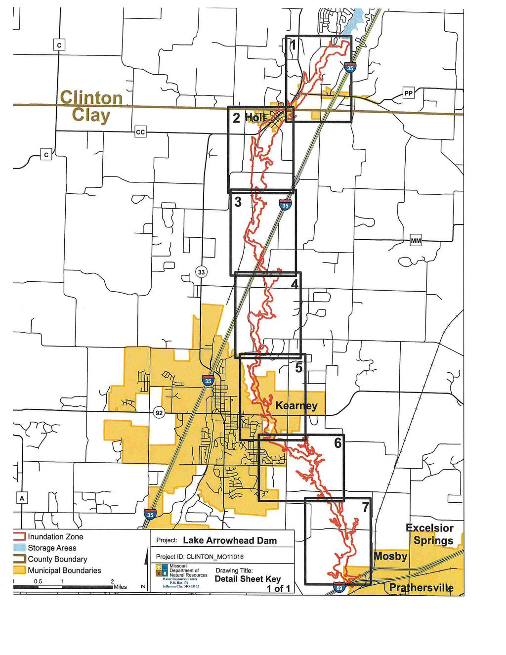
221

222

223
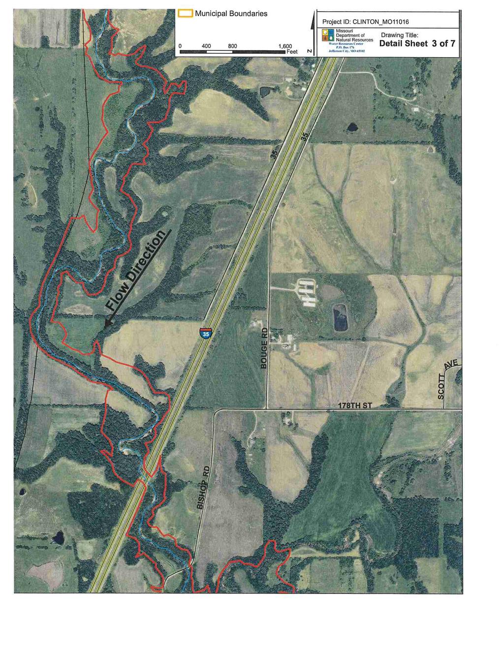
224

225
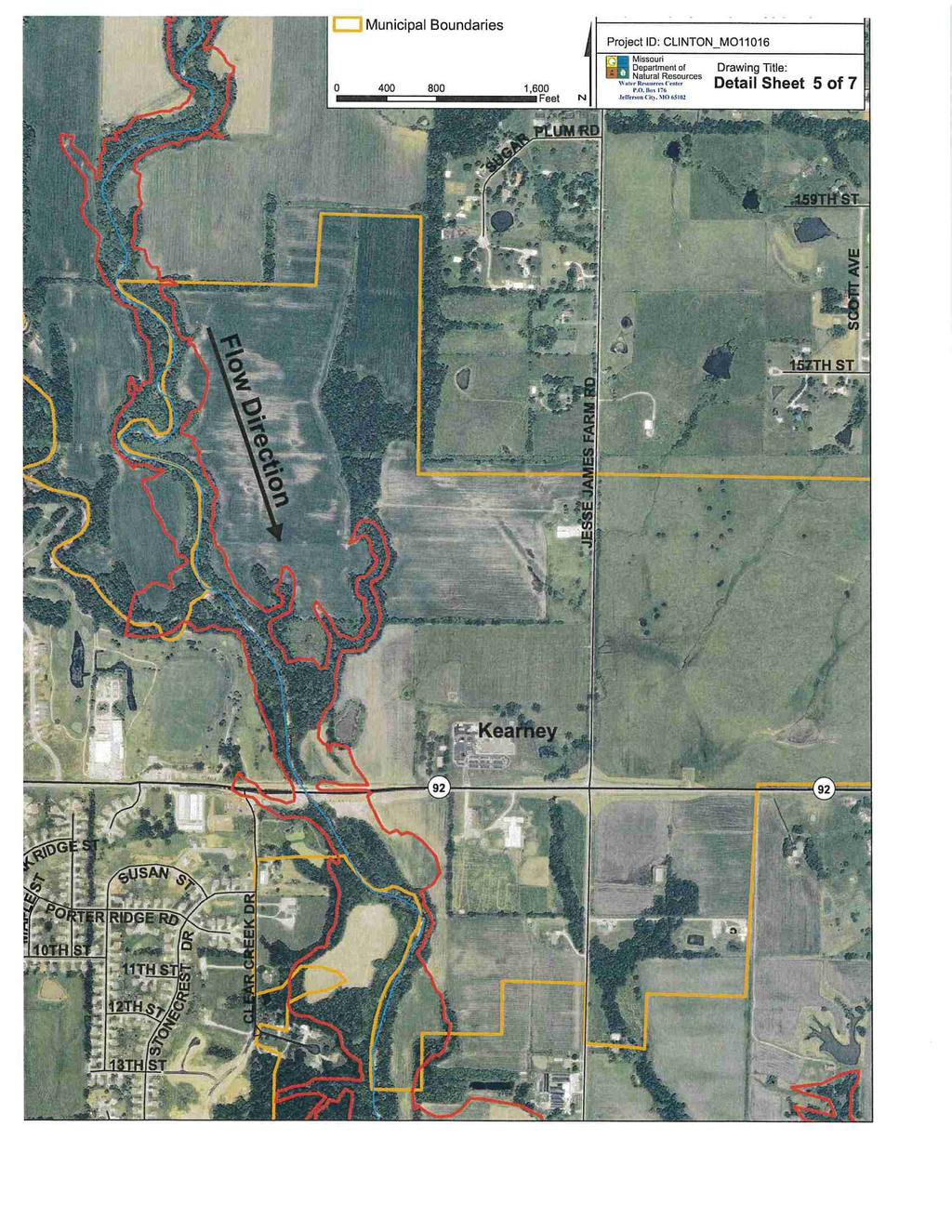
226
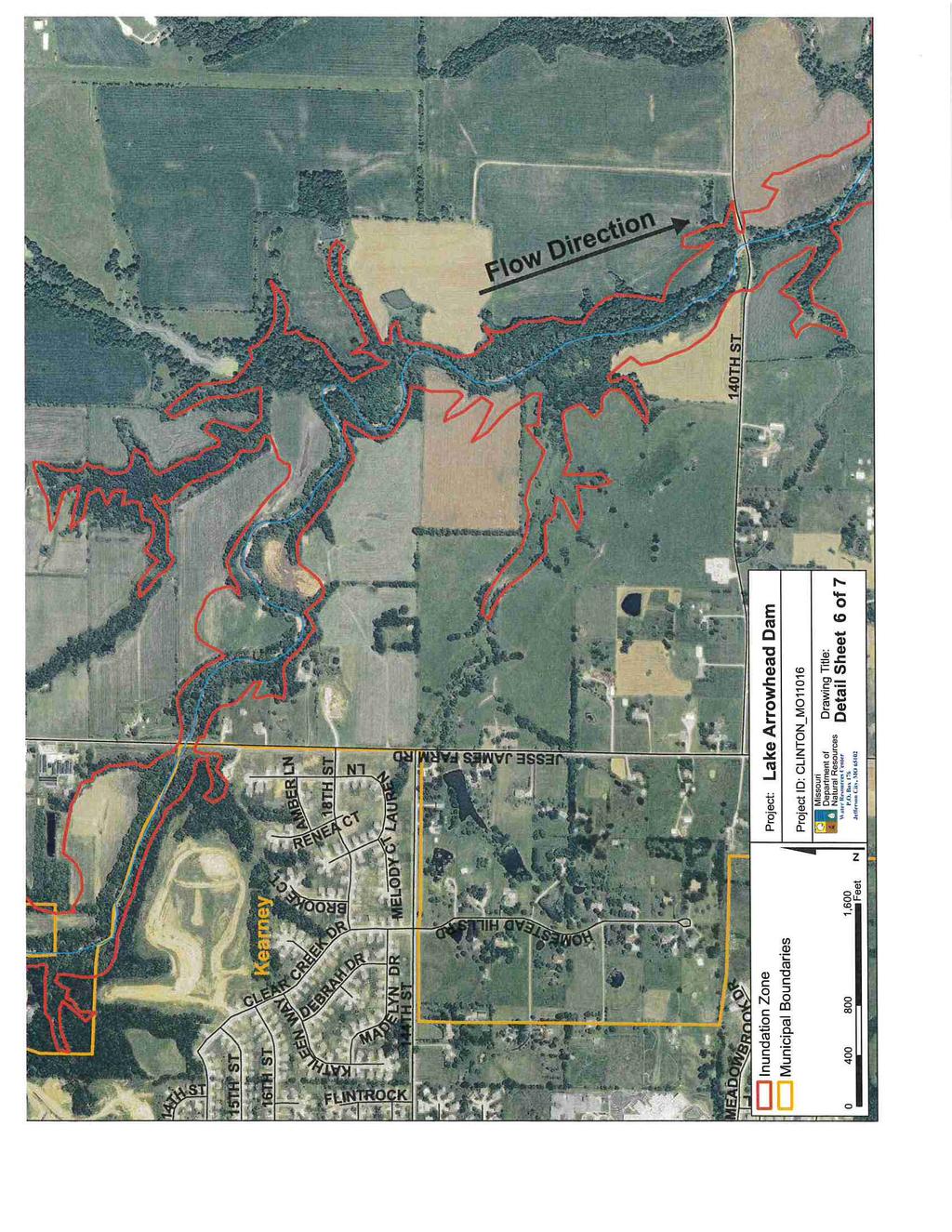
227

228
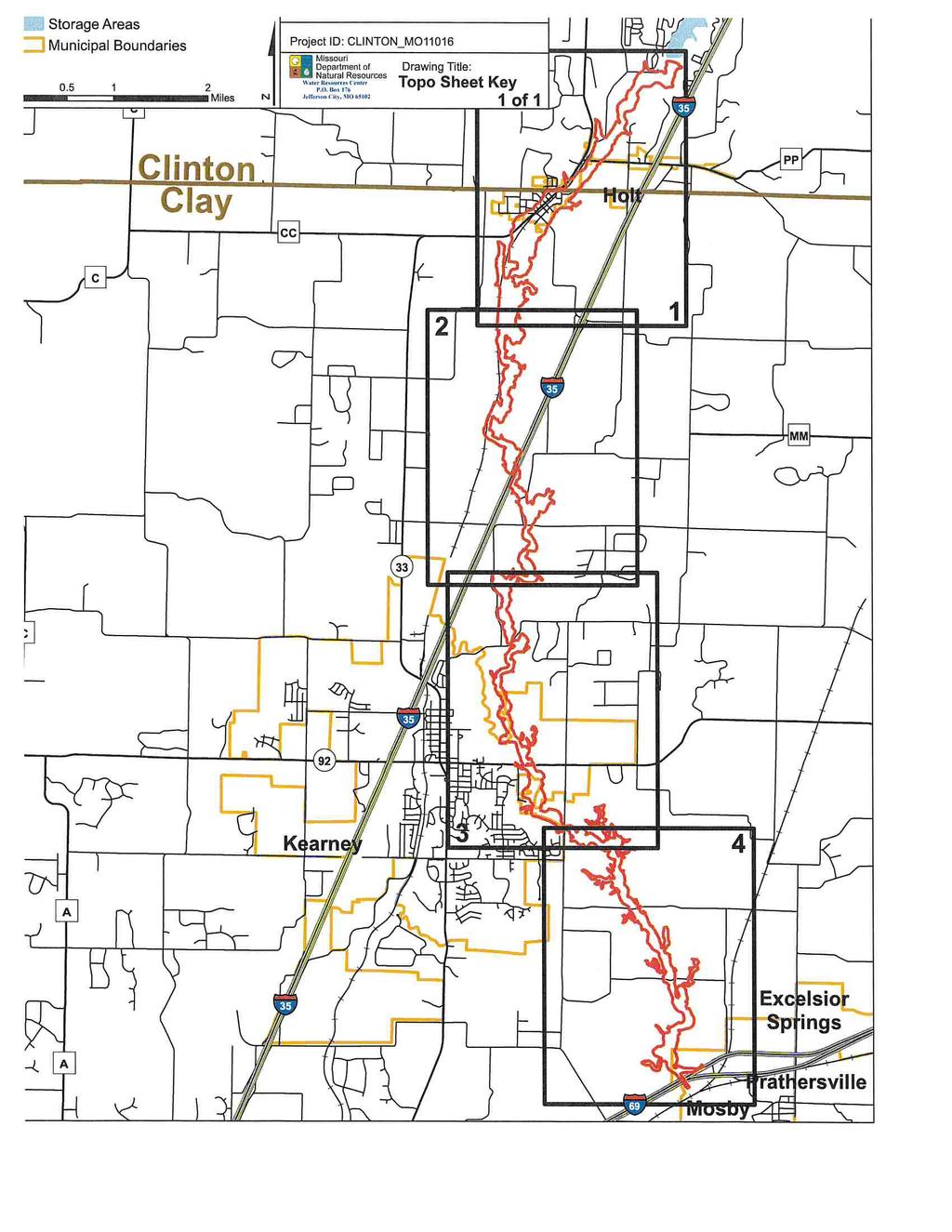
229

230

231

232

233
234
235
236
237
238
239
240
241
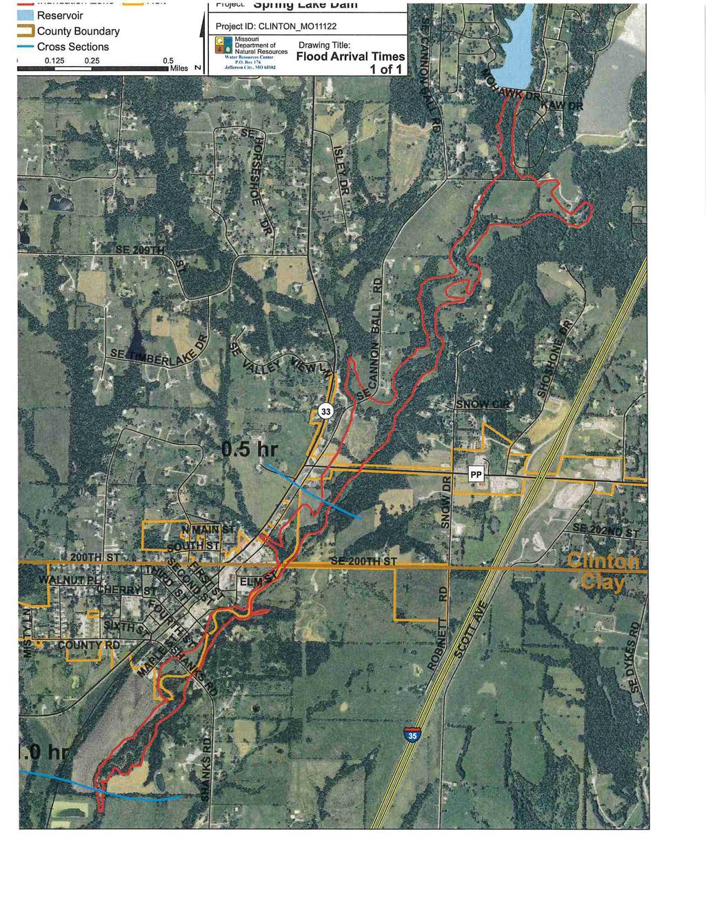
242

243

244

245
246
247
248
249
250
251
252
253

254

255

256

257

258

259
260
261
262
263
264

265
266
267

268
269
270
271
272
273
274
275
276
277
278
279
280
281
282
283
284
285
286
287

288
1.1 Purpose Background and Scope Plan Organization
 1 INTRODUCTION AND PLANNING PROCESS 1 INTRODUCTION AND PLANNING PROCESS... 1.1 1.1 Purpose... 1.1 1.2 Background and Scope... 1.1 1.3 Plan Organization... 1.2 1.4 Planning Process... 1.2 1.4.1 Multi-Jurisdictional
Shelby Hazard Mitigation Planning Committee
 CONTRIBUTORS Jurisdictional Representatives Shelby Hazard Mitigation Planning Committee Name Title Department Jurisdiction/Agency/Organiz Glenn Eagan Presiding Commissioner Administration County ation
1.1.1 Purpose. 1.2 Background and Scope
 1.1.1 Purpose Van Buren County and the 8 associated jurisdictions and associated agencies, business interests and partners of the county prepared this local hazard mitigation plan to guide hazard mitigation
Appendix F: Ozark special Road District Addendum
 Appendix F: Ozark special Road District Addendum F-1: Introduction and Planning Process F-1.1 Purpose The Christian County 2016 Multi-Jurisdictional Natural Hazards Mitigation Plan is an updated version
in coordination with Peoria County, Planning and Zoning Department
 Prepared by Amec Foster Wheeler Environment & Infrastructure Hazard Mitigation and Emergency Management Program in coordination with Peoria County, Planning and Zoning Department The purpose of hazard
LOCAL HAZARD MITIGATION PLAN UPDATE CHECKLIST
 D LOCAL HAZARD MITIGATION PLAN UPDATE CHECKLIST This section of the Plan includes a completed copy of the Local Hazard Mitigation Checklist as provided by the North Carolina Division of Emergency Management.
Stevens County, Washington Request for Proposal For A Countywide Multi-Jurisdictional All Hazard Mitigation Plan (Update)
") Stevens County, Washington Request for Proposal For A Countywide Multi-Jurisdictional All Hazard Mitigation Plan (Update) Project background A Multi-Jurisdictional All Hazard Mitigation Plan is a representation
Stevens County, Washington Request for Proposal For A Countywide Multi-Jurisdictional All Hazard Mitigation Plan (Update) Project background A Multi-Jurisdictional All Hazard Mitigation Plan is a representation
T-318. Hazard Mitigation Section TDEM Recovery, Mitigation, and Standards
 T-318 Local Hazard Mitigation Plan Requirements Hazard Mitigation Section TDEM Recovery, Mitigation, and Standards Raymond Mejia, Lead Hazard Mitigation Planner Samantha Aburto, Hazard Mitigation Planner
Town of Montrose Annex
 Town of Montrose Annex Community Profile The Town of Montrose is located in the Southwest quadrant of the County, east of the Town of Primrose, south of the Town of Verona, and west of the Town of Oregon.
Village of Blue Mounds Annex
 Village of Blue Mounds Annex Community Profile The Village of Blue Mounds is located in the southwest quadrant of the County, north of the town of Perry, west of the town of Springdale, and south of the
Sussex County All Hazard Mitigation Plan. Plan Executive Summary
 Sussex County All Hazard Mitigation Plan Plan Executive Summary March 2010 SUSSEX COUNTY ALL HAZARD MITIGATION PLAN SUMMARY March 2010 For questions and to make comments on this document, contact: Joseph
Section I: Introduction
 Section I: Introduction This section provides a general introduction to natural hazard mitigation planning in Clackamas County. In addition, Section I: Introduction addresses the planning process requirements
SECTION 1. INTRODUCTION
 1.1 BACKGROUND SECTION 1. INTRODUCTION Communities, residents and businesses have been faced with continually increasing costs associated with both natural and man-made hazards. Hazard mitigation is the
Mapping Flood Risk in the Upper Fox River Basin:
 Mapping Flood Risk in the Upper Fox River Basin: Vulnerable Populations and Adverse Health Effects Presented by: Angelina Hanson STUDY AREA: Wisconsin's Upper Fox River Basin Total Population 139,309.
Section 2. Introduction and Purpose of the LMS
 Section 2. Introduction and Purpose of the LMS 2.1 Introduction The Disaster Mitigation Act of 2000 (DMA 2000), signed into law by the President of the United States on October 30, 2000 (P.L. 106-390),
Executive Summary. Introduction and Purpose. Scope
 Executive Summary Introduction and Purpose This is the first edition of the Los Angeles Unified School District All-Hazard Mitigation Plan, and through completion of this plan the District continues many
HAZARD MITIGATION PLANNING
 HAZARD MITIGATION PLANNING Oswego County HMP Update Working Group Kickoff Meeting September 27, 2017 Agenda Welcoming Remarks Oswego County Emergency Management DHSES FEMA Introduce Executive Committee
SOUTH CENTRAL REGION MULTI-JURISDICTION HAZARD MITIGATION PLAN. Advisory Committee Meeting September 12, 2012
 SOUTH CENTRAL REGION MULTI-JURISDICTION HAZARD MITIGATION PLAN Advisory Committee Meeting September 12, 2012 AGENDA FOR TODAY Purpose of Meeting Engage All Advisory Committee Members Distribute Project
Pettis County Missouri 2018 Hazard Mitigation Plan
 Pettis County Missouri 2018 Hazard Mitigation Plan CONTRIBUTORS Jurisdictional Representatives Pettis County Hazard Mitigation Planning Committee Jurisdictional Representatives Pettis County Mitigation
INTRODUCTION 1. INTRODUCTION 1.1 HAZARD MITIGATION PLANNING 1.2 PLANNING REQUIREMENTS Local Mitigation Plans
 1. INTRODUCTION INTRODUCTION This section provides a brief introduction to hazard mitigation planning, local mitigation plan requirements, the grants associated with these requirements, and a description
In 1993, spring came in like a lion, but refused
 36 UNIVERSITIES COUNCIL ON WATER RESOURCES ISSUE 130, PAGES 36-40, MARCH 2005 FEMA and Mitigation: Ten Years After the 1993 Midwest Flood Norbert Director of Federal Insurance and Mitigation Division Federal
Michael Taylor, PE, CFM Project Manager, AECOM August 25, 2015
 Promoting FEMA s Flood Risk Products in the Lower Levisa Watershed Michael Taylor, PE, CFM Project Manager, AECOM August 25, 2015 Agenda Study Background Flood Risk Product Overview AOMI and Mitigation
G318 Local Mitigation Planning Workshop. Module 2: Risk Assessment. Visual 2.0
 G318 Local Mitigation Planning Workshop Module 2: Risk Assessment Visual 2.0 Unit 1 Risk Assessment Visual 2.1 Risk Assessment Process that collects information and assigns values to risks to: Identify
EXECUTIVE SUMMARY. Onondaga County Multi-Jurisdictional Planning Process
 EXECUTIVE SUMMARY The Onondaga County Multi-Jurisdictional All-Hazards Mitigation Plan was prepared in response to the Disaster Mitigation Act of 2000 (DMA 2000). DMA 2000 requires states and local governments
Dade County Natural Hazard Mitigation Plan
 Introduction to Mitigation Definition of Mitigation Mitigation is defined by FEMA as "...sustained action that reduces or eliminates longterm risk to people and property from natural hazards and their
LOCAL MITIGATION PLAN REVIEW CROSSWALK
 INSTRUCTIONS FOR USING THE PLAN REVIEW CROSSWALK FOR REVIEW OF LOCAL MITIGATION PLANS Attached is a Plan Review Crosswalk based on the Local Multi-Hazard Mitigation Planning Guidance, published by FEMA
EXECUTIVE SUMMARY. Greater Greenburgh Planning Area Planning Process
 EXECUTIVE SUMMARY The Greater Greenburgh Planning Area All-Hazards Mitigation Plan was prepared in response to the Disaster Mitigation Act of 2000 (DMA 2000). DMA 2000 requires states and local governments
NFIP Program Basics. KAMM Regional Training
 NFIP Program Basics KAMM Regional Training Floodplain 101 Homeowners insurance does not cover flood damage Approximately 25,000 flood insurance policies in KY According to BW12 analysis, approximately
County of Kaua'i Multi-Hazard Mitigation and Resilience Plan, 2015 Update
 Executive Summary: County of Kaua'i Multi-Hazard Mitigation and Resilience Plan Introduction to the Mitigation and Resilience Plan In this third plan, the longer term needs for sustaining mitigation efforts
Section 19: Basin-Wide Mitigation Action Plans
 Section 19: Basin-Wide Mitigation Action Plans Contents Introduction...19-1 Texas Colorado River Floodplain Coalition Mitigation Actions...19-2 Mitigation Actions...19-9 Introduction This Mitigation Plan,
COMMUNITY SUMMARY LINN COUNTY MULTI-JURISDICTIONAL HAZARD MITIGATION PLAN CITY OF LISBON
 COMMUNITY SUMMARY LINN COUNTY MULTI-JURISDICTIONAL HAZARD MITIGATION PLAN CITY OF LISBON This document provides a summary of the hazard mitigation planning information for the City of Lisbon that will
Appendix A. Mitigation Plan Crosswalk
 Appendix A Mitigation Plan Crosswalk Local Mitigation Plan Review and Approval Status Jurisdiction: Multi-jurisdictional Plan; 43 municipalities in Mercer, Hunterdon, Warren and Sussex Counties (see list
1 Introduction and Planning Process Purpose Background and Scope Plan Organization... 4
 1 INTRODUCTION AND PLANNING PROCESS 1 Introduction and Planning Process... 1 1.1 Purpose... 1 1.2 Background and Scope... 1 1.3 Plan Organization... 4 1.4 Planning Process... 4 1.4.1 Multi-Jurisdictional
LOCAL HAZARD MITIGATION PLAN REVIEW FEMA REGION VI AND STATE OF TEXAS
 LOCAL HAZARD MITIGATION FEMA REGION VI AND STATE OF TEXAS Instructions for using the attached Crosswalk Reference Document for Review and Submission of Local Mitigation Action Plans to the State Hazard
SECTION 1 INTRODUCTION
 SECTION 1 INTRODUCTION This section provides a general introduction to the Mississippi Emergency Management Agency (MEMA) District 9 Regional Hazard Mitigation Plan. It consists of the following five subsections:
Local Hazard Mitigation Plan Review. FEMA Region VI and the State of Texas
 Appendix E: Local Hazard Mitigation Plan Review For FEMA Region VI and the State of Texas LOCAL HAZARD MITIGATION PLAN REVIEW FOR PAGE 1 FEMA REGION 6 AND STATE OF TEXAS FOR FEMA USE ONLY Instructions
Discovery Report. Cache River Watershed, Alexander, Johnson, Pulaski, and Union Counties, Illinois
 Discovery Report Cache River Watershed, 07140108 Alexander, Johnson, Pulaski, and Union Counties, Illinois 12/21/2012 i Project Area Community List Community Name Alexander County Village of Tamms Johnson
COMMUNITY SUMMARY LINN COUNTY MULTI-JURISDICTIONAL HAZARD MITIGATION PLAN CITY OF CENTRAL CITY
 COMMUNITY SUMMARY LINN COUNTY MULTI-JURISDICTIONAL HAZARD MITIGATION PLAN CITY OF CENTRAL CITY This document provides a summary of the hazard mitigation planning information for the City of Central City
ASFPM Partnerships for Statewide Mitigation Actions. Alicia Williams GIS and HMP Section Manager, Amec Foster Wheeler June 2016
 ASFPM Partnerships for Statewide Mitigation Actions Alicia Williams GIS and HMP Section Manager, Amec Foster Wheeler June 2016 Summary The Concept Leveraging Existing Data and Partnerships to reduce risk
A Flood Mitigation Plan for the Non-Tidal N.J. Section of the Delaware River Basin. Mercer County Kick-off Meeting December 6, 2006
 A Flood Mitigation Plan for the Non-Tidal N.J. Section of the Delaware River Basin Mercer County Kick-off Meeting December 6, 2006 The Delaware River. crosses many boundaries Four states: DE, PA, NJ, NY
Garfield County NHMP:
 Garfield County NHMP: Introduction and Summary Hazard Identification and Risk Assessment DRAFT AUG2010 Risk assessments provide information about the geographic areas where the hazards may occur, the value
HAZARD MITIGATION PLAN POINT OF CONTACT. MUNICIPAL PROFILE
 HAZARD MITIGATION PLAN POINT OF CONTACT troseberry@easton-pa.gov cmanges@easton-pa.gov MUNICIPAL PROFILE MUNICIPAL PARTICIPATION Compliance with the National Flood Insurance Program (NFIP) Identify source
PART 3 LOCAL MITIGATION PLANS
 PART 3 LOCAL MITIGATION PLANS Local Mitigation Plan requirements in 44 CFR, Part 201.6 of the Interim Final Rule (the Rule) apply to both local jurisdictions and Tribal governments that elect to participate
Stoddard County Natural Hazard Mitigation Plan-Five Year Update SECTION 3
 SECTION 3 CITY/COUNTY CAPABILITY ASSESSMENT Mitigation Management Policies This section is an update from the approved Stoddard County 2004 Plan. Specific updates include new information on population
BUTTS COUNTY, GEORGIA AND INCORPORATED AREAS
 BUTTS COUNTY, GEORGIA AND INCORPORATED AREAS Butts County Community Name Community Number BUTTS COUNTY (UNICORPORATED AREAS) 130518 FLOVILLA, CITY OF 130283 JACKSON, CITY OF 130222 JENKINSBURG, TOWN OF
Multi-Jurisdictional. Multnomah County. Natural Hazards Mitigation Plan. Public Comment DRAFT Nov. 7, 2016
 Multnomah County Multi-Jurisdictional Natural Hazards Mitigation Plan Participating Jurisdictions: Multnomah County City of Fairview City of Gresham City of Troutdale City of Wood Village Public Comment
Truckloads (at 25 tons/truck) of building debris 90
 of building debris 90") Marlborough Marlborough is a rural community in Hartford County covering a land area of 23.3 square miles and with an estimated population of 6,410. Elevation ranges from about 160 to 800 feet. The Town
Marlborough Marlborough is a rural community in Hartford County covering a land area of 23.3 square miles and with an estimated population of 6,410. Elevation ranges from about 160 to 800 feet. The Town
LOCAL HAZARD MITIGATION PLAN REVIEW WORKSHEET FEMA REGION 2 Jurisdiction: Jurisdiction: Title of Plan: Date of Plan: Address:
 REVIEW AD APPROVAL TATU Title of Plan: Date of Plan: Local Plan submitted by: Address: Title: Agency: Phone umber: E-Mail: tate Reviewer: Title: Date: FEMA Reviewer: Title: Date: FEMA QA/QC: Title: Date:
ANNEX B: TOWN OF BLUE RIVER
 ANNEX B: TOWN OF BLUE RIVER B.1 Community Profile Figure B.1 shows a map of the Town of Blue River and its location within Summit County. Figure B.1. Map of Blue River Summit County (Blue River) Annex
1.1. PURPOSE 1.2. AUTHORITIES 1. INTRODUCTION
 1. INTRODUCTION This section briefly describes hazard mitigation planning requirements, associated grants, and this Standard State Hazard Mitigation Plan (SHMP) update s composition. HMPs define natural
PLANNING PROCESS. Table of Contents. List of Tables
 PLANNING PROCESS Table of Contents 1.1 Narrative Description of the Planning Process... 1-1 1.2 Steering Committee & Public Involvement... 1-7 1.2.1 Steering Committee Participant Solicitation... 1-7 1.2.2
FEMA s Flood Map Modernization Preparing for FY09 and Beyond: Integrated Flood Data Update, Risk Assessment, and Mitigation Planning
 FEMA s Flood Map Modernization Preparing for FY09 and Beyond: Integrated Flood Data Update, Risk Assessment, and Mitigation Planning DRAFT CONCEPT PAPER June 1, 2007 Integrated Flood Data Update, Risk
Northern Kentucky University 2018 Hazard Mitigation Plan. Public Kick-Off Meeting March 20, 2018
 Northern Kentucky University 2018 Hazard Mitigation Plan Public Kick-Off Meeting March 20, 2018 Agenda Welcome Hazard Mitigation Planning 101 Hazard Identification Exercises Next Steps Jeff Baker, NKU
Strategies for Increasing Flood Resiliency
 Strategies for Increasing Flood Resiliency Flood Hazard Mitigation Steve Ferryman, CFM Mitigation Branch Chief Ohio Emergency Management Agency Ohio EMA Mitigation Branch The mission of the Mitigation
Volusia County Floodplain Management Plan 2012
 Volusia County Floodplain Management Plan 2012 Introduction The National Flood Insurance Program (NFIP) provides federally supported flood insurance in communities that regulate development in floodplains.
APPENDIX D PLANNING PROCESS DOCUMENTATION
 APPENDIX D PLANNING PROCESS DOCUMENTATION This appendix includes the following: 1. Meeting Agendas 2. Meeting Minutes 3. Meeting Sign-In Sheets 4. Public Survey Summary Results 1) Introductions AGENDA
HAZARD MITIGATION PLAN POINT OF CONTACT MUNICIPAL PROFILE
 HAZARD MITIGATION PLAN POINT OF CONTACT northcatasauquaema@yahoo.com scheirerg@gmail.com MUNICIPAL PROFILE MUNICIPAL PARTICIPATION Compliance with the National Flood Insurance Program (NFIP) Identify source
Karlstad, Sweden. Local progress report on the implementation of the 10 Essentials for Making Cities Resilient ( )
") Karlstad, Sweden Local progress report on the implementation of the 10 Essentials for Making Cities Resilient (2013-2014) Mayor: Ulf Nyqvist Name of focal point: -Anna -Sjödin Organization: -Karlstad Municipality
Karlstad, Sweden Local progress report on the implementation of the 10 Essentials for Making Cities Resilient (2013-2014) Mayor: Ulf Nyqvist Name of focal point: -Anna -Sjödin Organization: -Karlstad Municipality
Section 1: Introduction and Planning Process
 Section 1: Introduction and Planning Process Requirement 201.6(b): In order to develop a more comprehensive approach to reducing the effects of natural disasters, the planning process shall include: 1)
Crawford County Multi-Jurisdiction Natural Hazard Mitigation Plan Meramec Regional Planning Commission March 2018
 Crawford County Multi-Jurisdiction Natural Hazard Mitigation Plan Meramec Regional Planning Commission March 2018 4 Industrial Drive, St. James, MO 65559 Phone: (573) 265-2993 Fax: (573) 265-3550 Crawford
Delaware River Basin Commission s Role in Flood Loss Reduction Efforts
 Delaware River Basin Commission s Role in Flood Loss Reduction Efforts There is a strong need to reduce flood vulnerability and damages in the Delaware River Basin. This paper presents the ongoing role
9.35 VILLAGE OF TULLY
 9.35 VILLAGE OF TULLY This section presents the jurisdictional annex for the Village of Tully. A.) HAZARD MITIGATION PLAN POINT OF CONTACT Primary Point of Contact Elizabeth L. Greenwood, Mayor 5833 Meetinghouse
Lake County Hazard Identification and Risk Assessment Plan Lake County Hazard Mitigation Committee
 Lake County Hazard Identification and Risk Assessment Plan Lake County Hazard Mitigation Committee Request for Proposals Bid Deadline: Hard Copy Due 4:00 PM Mountain Standard Time (MST) Friday March 9,
HAZARD MITIGATION PLAN POINT OF CONTACT MUNICIPAL PROFILE
 HAZARD MITIGATION PLAN POINT OF CONTACT hankvb@entermail.net khorvath@kceinc.com MUNICIPAL PROFILE MUNICIPAL PARTICIPATION Compliance with the National Flood Insurance Program (NFIP) Topic 1. Staff Resources
HAZARD MITIGATION PLAN POINT OF CONTACT MUNICIPAL PROFILE
 HAZARD MITIGATION PLAN POINT OF CONTACT akelly@bethlehemtownship.org dbruce@bethlehemtownship.org MUNICIPAL PROFILE MUNICIPAL PARTICIPATION Compliance with the National Flood Insurance Program (NFIP) 1.
9.36 TOWN OF VAN BUREN
 9.36 TOWN OF VAN BUREN This section presents the jurisdictional annex for the Town of Van Buren. A.) HAZARD MITIGATION PLAN POINT OF CONTACT Primary Point of Contact David J. Pringle, Code Enforcement
SECTION 6: MITIGATION STRATEGIES
 SECTION 6: MITIGATION STRATEGIES This section presents mitigation actions for Somerset County to reduce potential exposure and losses identified as concerns in the Risk Assessment portion of this plan.
Mitigation Strategies
 Mitigation Strategies Introduction Michigan State University Mitigation Goals Identification and Analysis of Mitigation Actions Recommendation and Prioritization of Mitigation Actions Potential Funding
A.) HAZARD MITIGATION PLAN POINT OF CONTACT
 HAZARD MITIGATION PLAN POINT OF CONTACT") 9.6 TOWN OF CLAY This section presents the jurisdictional annex for the Town of Clay. A.) HAZARD MITIGATION PLAN POINT OF CONTACT Primary Point of Contact Mark Territo, Commissioner of Planning & Development
9.6 TOWN OF CLAY This section presents the jurisdictional annex for the Town of Clay. A.) HAZARD MITIGATION PLAN POINT OF CONTACT Primary Point of Contact Mark Territo, Commissioner of Planning & Development
Simsbury. Challenges Capitol Region Natural Hazards Mitigation Plan Update - Page 356
 Simsbury Simsbury is a suburban community of about 23,600 located in the western portion of the Capitol Region. Its land area encompasses 33.9 square miles. Elevation in town generally ranges from about
CHAPTER THREE Natural Hazard Mitigation Strategy
 CHAPTER THREE Natural Hazard Mitigation Strategy Chapter 3 Section All Sections Updates to Section Revised Natural Hazards Introduction and all Sections to change Natural Hazards Subcommittee to Committee.
Hazard Mitigation & Resiliency
 Hazard Mitigation & Resiliency Goal: Encourage resiliency and sustainable development by protecting development from natural hazards. In Maryland Heights, the Comprehensive Plan is the responsibility of
DeSoto Parish Hazard Mitigation Plan Update Kick-off Meeting. February 16, 2016 Grand Cane, LA
 DeSoto Parish Hazard Mitigation Plan Update Kick-off Meeting February 16, 2016 Grand Cane, LA Introductions Officials Mitigation Steering Committee members SDMI team members GOHSEP hazard mitigation team
Iberia Parish Hazard Mitigation Plan Update Plan Steering Committee Kick-off Meeting
 Iberia Parish Hazard Mitigation Plan Update Plan Steering Committee Kick-off Meeting July 9, 2014 Iberia Parish Council Chambers New Iberia, Louisiana Introductions Officials Steering Committee members
Planning Process Documentation
 Appendix D Planning Process Documentation This appendix includes: 1. Meeting Agendas 2. Meeting Minutes 3. Meeting Sign-In Sheets AGENDA Wake County Multi-Jurisdictional Hazard Mitigation Plan West Wake
Modernization, FEMA is Recognizing the connection between damage reduction and
 EXECUTIVE SUMMARY Every year, devastating floods impact the Nation by taking lives and damaging homes, businesses, public infrastructure, and other property. This damage could be reduced significantly
Hazard Mitigation Plan Planning Perspective
 7. A. Hazard Mitigation Plan Planning Perspective B. Public Meeting Notice A. Hazard Mitigation Plan Planning Perspective York County Hazard Mitigation Plan Hazard Mitigation Plan Planning Perspective
SECTION 3: PLANNING PROCESS
 INTRODUCTION This section includes a description of the planning process used to develop the HMP, including how it was prepared, who was involved in the process, and how the public was involved. To ensure
APPENDIX A: REFERENCES
 APPENDIX A: REFERENCES 2002 Census of Agriculture. http://www.agcensus.usda.gov/ 2007 Kansas Severe Weather Awareness Week Information Packet. National Weather Service. 2007. www.crh.noaa.gov/image/top2007kansas.pdf
Mitigation Measures: Sound Investments in Disaster Recovery
 ISSUE 14 EDITOR S NOTE While FEMA is best known for emergency assistance after a disaster, the agency s support of mitigation programs to help identify and reduce risks to life and property before a disaster
Mitigation Action Plan Alamance County
 Mitigation Action Plan Alamance County The Mitigation Action Plan for Alamance County is divided into two subsections: 7.1 Status of Previously Adopted Mitigation Actions 7.2 New 2015 Mitigation Actions
REQUEST FOR PROPOSALS. Planning in Water s Way: Flood Resilient Economic Development Strategy for the I-86 Innovation Corridor
 REQUEST FOR PROPOSALS Planning in Water s Way: Flood Resilient Economic Development Strategy for the I-86 Innovation Corridor Southern Tier Central Regional Planning and Development Board (STC) is seeking
TERREBONNE PARISH HAZARD MITIGATION PLAN UPDATE
 TERREBONNE PARISH HAZARD MITIGATION PLAN UPDATE HAZARD MITIGATION PLAN UPDATE COMMITTEE KICK-OFF MEETING May 22, 2014 A World of Solutions 0 PRESENTATION AGENDA I. INTRODUCTIONS AND WELCOME II. PURPOSE,
9.10 HEIDELBERG TOWNSHIP
 9.10 HEIDELBERG TOWNSHIP This section presents the jurisdictional annex for Heidelberg Township. A. HAZARD MITIGATION PLAN POINT OF CONTACT Name Title/ Department Address Telephone Fax Email Primary Point
HAZARD MITIGATION PLAN POINT OF CONTACT MUNICIPAL PROFILE
 HAZARD MITIGATION PLAN POINT OF CONTACT glendonboro@rcn.com glendonboro@rcn.com MUNICIPAL PROFILE MUNICIPAL PARTICIPATION Identify source of information, if different Topic from the one listed 1. Staff
Multi-Jurisdictional Hazard Mitigation Plan. Data Collection Questionnaire. For Local Governments
 Multi-Jurisdictional Hazard Mitigation Plan Data Collection Questionnaire County: For Local Governments Jurisdiction: Return to: Marcus Norden, Regional Planner BRP&EC Please complete this data collection
Cumberland County, NJ. Risk MAP Project Status Update April 22, 2013
 Cumberland County, NJ Risk MAP Project Status Update April 22, 2013 Agenda Project Team Milestones Risk MAP Overview Study Scope overview Regulatory products Non-regulatory products Proposed Schedule Risk
USACE Silver Jackets, the Missouri State Risk Management Team and State Hazard Mitigation
 MfSMA Conference, State Risk Management Team Meeting Things You Want To Know USACE Silver Jackets, the Missouri State Risk Management Team and State Hazard Mitigation Brian Rast, PE, CFM, PMP Silver Jackets
9.2 ALBURTIS BOROUGH. This section presents the jurisdictional annex for Alburtis Borough. A. HAZARD MITIGATION PLAN POINT OF CONTACT
 9.2 ALBURTIS BOROUGH This section presents the jurisdictional annex for Alburtis Borough. A. HAZARD MITIGATION PLAN POINT OF CONTACT Name Title/ Department Address Telephone Fax Email Primary Point of
Georgia Flood M.A.P. Program
 Georgia Flood M.A.P. Program Georgia Flood M.A.P. Program The Upper Chattahoochee River Basin Risk MAP Project Transitioning State Program to align with FEMA s Risk MAP Program Increase focus on risk assessment
HAZARD MITIGATION PLAN REVIEW TOOL Marion County, IOWA APPROVED 1 st Review
 Jurisdiction: Marion County, IA Local Point of Contact: Jeremy Rounds Title: Regional Planner Agency: Southern Iowa Council of Governments Phone Number: 641.782.8491 Funding Source: Title of Plan: Marion
FREQUENTLY ASKED QUESTION ABOUT FLOODPLAINS Michigan Department of Environmental Quality
 FREQUENTLY ASKED QUESTION ABOUT FLOODPLAINS Michigan Department of Environmental Quality WHAT IS A FLOOD? The National Flood Insurance Program defines a flood as a general and temporary condition of partial
9.24 WEISENBERG TOWNSHIP
 9.24 WEISENBERG TOWNSHIP This section presents the jurisdictional annex for Weisenberg Township. A. HAZARD MITIGATION PLAN POINT OF CONTACT Name Title/ Department Address Telephone Fax Email Primary Point
TABLE OF CONTENTS. Foreword... i. Executive Summary...1. Prerequisites... P.1. Participating Jurisdictions... P.1. Participation Requirements... P.
 TABLE OF CONTENTS Foreword... i Executive Summary...1 Prerequisites... P.1 Participating Jurisdictions... P.1 Participation Requirements... P.2 Record of Participation... P.3 Sample Adoption Resolution...
Repetitive Loss Area Revisit # 6 Walter Road Area Jefferson Parish
 Repetitive Loss Area Revisit # 6 Walter Road Area Jefferson Parish www.floodhelp.uno.edu Supported by FEMA Acknowledgement The compilation if this report was managed by Erin Patton, CFM, a UNO-CHART Research
New Jersey Department of Environmental Protection. Five-Year Floodplain Management Work Plan
 New Jersey Department of Environmental Protection Five-Year Floodplain Management Work Plan September 30, 2004 I. State Authority New Jersey Department of Environmental Protection Five-Year Floodplain
Tangipahoa Parish Hazard Mitigation Plan Update Mitigation Steering Committee Kick-off Meeting. September 9, 2014 Hammond, LA
 Tangipahoa Parish Hazard Mitigation Plan Update Mitigation Steering Committee Kick-off Meeting September 9, 2014 Hammond, LA Introductions Officials Mitigation Steering Committee members SDMI team members
Chemung HUC-8 Watershed Project. February 1, 2011
 Chemung HUC-8 Watershed Project Kickoff Bi Fl t NY Big Flats, NY February 1, 2011 Introductions FEMA Region II Alan Springett, Senior Engineer, FEMA Risk Analysis Risk Assessment Lead Robert Schaefer,
HAZARD MITIGATION PLAN POINT OF CONTACT MUNICIPAL PROFILE
 HAZARD MITIGATION PLAN POINT OF CONTACT nazareth50em1@gmail.com jessicagteel@gmail.com MUNICIPAL PROFILE MUNICIPAL PARTICIPATION 3. Describe how the public will be engaged in the current planning process
Hazard Mitigation Planning
 Hazard Mitigation Planning Mitigation In order to develop an effective mitigation plan for your facility, residents and staff, one must understand several factors. The first factor is geography. Is your