Flood Hazards and Flood Risk, the Impact of a Changing Climate
|
|
|
- Warren Fox
- 5 years ago
- Views:
Transcription
1 Flood Hazards and Flood Risk, the Impact of a Changing Climate Sally A. McConkey, P.E. CFM, D. WRE. Illinois State Water Survey June 14, 2017
2 Topics ISWS Coordinated Hazard Assessment and Mapping Program Severity and extent of flooding Status of regulatory flood hazard mapping and studies Urban flooding Impacts of climate change on flood hazards Resilient Illinois
3 Coordinated Hazard Assessment and Mapping Program (CHAMP) Federal Emergency Management Agency (FEMA) Cooperating Technical Partner Develop the regulatory Flood Insurance Rate Maps (FIRMs) for Illinois Perform the hydrologic and hydraulic analyses used to identify flooding impact areas Review proposed changes to FIRMs on behalf of FEMA Conduct public outreach Coordinate with IDNR/OWR and IEMA Conduct urban stormwater management analyses Perform Flood Risk Assessments Research community resilience

4 Illinois Federal Disaster Declarations since Federal Disaster Declarations since 1965 (60 since 1957) 38 Federal Major Disaster Declarations involved flooding; 12 between 2000 and te-tribalgovernment/55?field_disaster_type_ter m_tid_1=6837&=go /Documents/Plan_IllMitigationPlan.pdf
 paper format Digital Flood Insurance Rate Map")
5 Flood Hazard Identification- 1% annual chance of inundation Flood Insurance Rate Map (FIRM) paper format Digital Flood Insurance Rate Map (DFIRM) 5

6 Status of Floodplain Mapping (1% annual chance flood) 25 Counties effective Flood Insurance Rate Maps (FIRMs) are paper format based on data 20 or more years old 5 funded for updated digital mapping (Peoria, Madison, Monroe, St. Clair, and Pulaski) 2 funded for new flood studies (Ford & Warren) 2 proposed for FFY2017 funding for study updates and digital mapping (Effingham & Clay) 16 counties with no updates scheduled Effective Digital FIRMs in 77 counties have limited updated flood data, most are based on out of date study data


7 Streams with 1% annual chance Only 21% of mapped stream miles are based on detailed engineering analyses floodplain mapped Only 15% of all mapped stream miles are considered valid

8 Urban Flooding Awareness Act Report $2.319 billion in documented damages between 2007 and 2014 Map shows number of claims per county $1,240 billion were private claims that typically represent basement flooding and sewer backup. Although the largest percentage of insurance claims is from northeastern Illinois, urban flood damages and problems occur statewide in urban areas.

9 Increasingly flooding damage is occurring outside the mapped floodplain Legend Mapped Floodplain Claims Per Census Block
10 Flood hazard identification and Infrastructure Design (design storm approach examples) Floodplains are identified by modeling the impact of statistically extreme rainfall events; e.g. the expected 100-year rainfall (1% annual chance of occurrence). Stream gage data is used when available. Storm sewers are typically designed to convey a rainfall that occurs on average once in 10 years, the 10-year rainfall (10% annual chance of occurrence) New bridge construction is designed for the 100-year event Older bridges may only have a design capacity for a 15- year event
11 Impact of Climate Change Total inches of rain for event* Design Storm: NWS Technical Paper 40 (1961) ISWS Bulletin 70 (1989) Mid Century Markus, et. al. (2016) Late Century Markus, et. al. (2016) Riverine floodplain / Stormwater Detention 100-year, 24 hour Storm sewer 10-year, 2 hour NA** NA** *Near O'Hare Airport in Cook County ** 10-year, 24 hour expected 20 to 25% increase
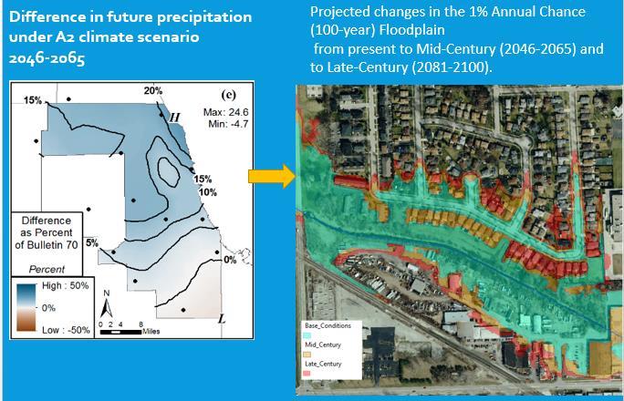
12
 Expected")
13 Future Uncertainty & Risk Management Expected Value Average Precipitation Change for North America (IPCC, 2013) Expected Value
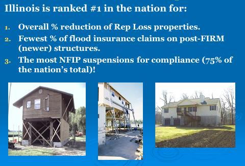
14 Resilience in Practice Illinois Statutes recognize the importance of water management Illinois higher regulatory standards, floodplain fill/ encroachment is limited to a 0.1 foot rise compared to the national standard of 1.0 foot allowable rise Regulation of construction in stream floodway Training and support of Local Floodplain Managers Communities are encouraged to adopt even higher standards (Community Rating System) Mitigation is a high priority, IDNR/OWR and DCEO providing the local match (75% Federal: 25% Local) over 5500 structures have been purchased and no longer at risk.
15
16 Conclusions Flooding is leading natural disaster in Illinois Flooding is expected to increase in frequency and magnitude due to climate change The extent of future flood hazards need to be identified for strategic planning Floodplain management standards above the minimum Federal requirements build resilience Aggressive mitigation actions such as buying out at-risk structures reduces flood risk
17 Resilient Future Update rainfall assessment using climate models to identify precipitation patterns and design storms Use future design storms for floodplain and stormwater management planning and design Use risk based assessment for major projects Apply higher standards for new and replacement infrastructure Disseminate actionable information to local officials Invest in mitigation Retreat from floodplains
BUTTS COUNTY, GEORGIA AND INCORPORATED AREAS
 BUTTS COUNTY, GEORGIA AND INCORPORATED AREAS Butts County Community Name Community Number BUTTS COUNTY (UNICORPORATED AREAS) 130518 FLOVILLA, CITY OF 130283 JACKSON, CITY OF 130222 JENKINSBURG, TOWN OF
Bucks County, PA Flood Risk Review Meeting. November 2014
 Bucks County, PA Flood Risk Review Meeting November 2014 Agenda for Today Risk MAP Program overview Overview of non-regulatory Flood Risk Products and datasets Discuss mitigation action Technical overview
Oklahoma High Water Marks. CTP Community of Practice April 20, 2017
 Oklahoma High Water Marks CTP Community of Practice April 20, 2017 The Rains Came into Region 6 in May 2015 2 Disaster DR-4222 30 Day Rainfall 3 NOAA Rainfall Amounts / Rainfall Frequency 4 The Rains in
NFIP Program Basics. KAMM Regional Training
 NFIP Program Basics KAMM Regional Training Floodplain 101 Homeowners insurance does not cover flood damage Approximately 25,000 flood insurance policies in KY According to BW12 analysis, approximately
Non Regulatory Risk MAP Products Flood Depth and Probability Grids
 Non Regulatory Risk MAP Products Flood Depth and Probability Grids Virginia Floodplain Management Association 2015 Floodplain Management Workshop October 29th, 2015 Nabil Ghalayini, P.E., PMP, D.WRE, CFM
Improving Coordinated Flood Preparedness and Response
 Improving Coordinated Flood Preparedness and Response Illinois Silver Jackets Hank DeHaan Rock Island and Saint Louis Districts October 2011 US Army Corps of Engineers Illinois Silver Jackets Program Illinois
Delaware River Basin Commission s Role in Flood Loss Reduction Efforts
 Delaware River Basin Commission s Role in Flood Loss Reduction Efforts There is a strong need to reduce flood vulnerability and damages in the Delaware River Basin. This paper presents the ongoing role
Michael Taylor, PE, CFM Project Manager, AECOM August 25, 2015
 Promoting FEMA s Flood Risk Products in the Lower Levisa Watershed Michael Taylor, PE, CFM Project Manager, AECOM August 25, 2015 Agenda Study Background Flood Risk Product Overview AOMI and Mitigation
Urban Flooding in Illinois The Changing Face of Floods
 Urban Flooding in Illinois The Changing Face of Floods Chicago Albany Park Neighborhood June 2008 National Academies of Science Chicago, IL September 19, 2017 Welcome to Illinois Floods? Really? Illinois
FREQUENTLY ASKED QUESTION ABOUT FLOODPLAINS Michigan Department of Environmental Quality
 FREQUENTLY ASKED QUESTION ABOUT FLOODPLAINS Michigan Department of Environmental Quality WHAT IS A FLOOD? The National Flood Insurance Program defines a flood as a general and temporary condition of partial
Vision to Action: Creating and Using a Flood Risk Assessment for Identifying Mitigation Options
 Vision to Action: Creating and Using a Flood Risk Assessment for Identifying Mitigation Options Lisa Graff, CFM, GISP Clayton Ballerine, CFM Brad McVay, CFM, GISP University of Illinois Prairie Research
CRISP COUNTY, GEORGIA AND INCORPORATED AREAS
 CRISP COUNTY, GEORGIA AND INCORPORATED AREAS Community Name Community Number ARABI, CITY OF 130514 CORDELE, CITY OF 130214 CRISP COUNTY (UNINCORPORATED AREAS) 130504 Crisp County EFFECTIVE: SEPTEMBER 25,
Technical Memorandum 3.4 E Avenue NW Watershed Drainage Study. Appendix E Floodplain Impacts and Implications Memo
 Technical Memorandum 3.4 E Avenue NW Watershed Drainage Study Appendix E Floodplain Impacts and Implications Memo September 8, 2017 City of Cedar Rapids E Avenue Watershed Drainage Study Memo Date: Tuesday,
Table 1: Federal, State and Local Government Rules applicable to LOMRs/CLOMRS submittal
 MnDNR LOMC Guide This document has been prepared by the Minnesota Department of Natural Resources floodplain staff and is intended to provide assistance with LOMR/CLOMR submittals. This information is
Use of FEMA Non regulatory Flood Risk Products in Planning
 Use of FEMA Non regulatory Flood Risk Products in Planning Georgia Association of Floodplain Managers Annual Conference March 24, 2016 What are the Non regulatory Flood Risk products? Go beyond the basic
CITY OF VESTAVIA HILLS
 CITY OF VESTAVIA HILLS FLOODPLAIN MANAGEMENT PLAN KICK-OFF MEETING MARCH 10, 2015 FLOODPLAIN MANAGEMENT PLANNING COMMITTEE Representative of the following categories Preventive Maintenance (e.g., codes)
Discovery Report. Cache River Watershed, Alexander, Johnson, Pulaski, and Union Counties, Illinois
 Discovery Report Cache River Watershed, 07140108 Alexander, Johnson, Pulaski, and Union Counties, Illinois 12/21/2012 i Project Area Community List Community Name Alexander County Village of Tamms Johnson
SECTION 9: MAPS AND DATA
 SECTION 9: MAPS AND DATA Contents 9.1. NFIP Maps and Data... 9-2 9.1.1. Adopting and enforcing NFIP floodplain maps and data... 9-2 9.1.2. Adopting and enforcing more restrictive data... 9-2 9.1.3. Annexations...
PARK COUNTY, WYOMING AND INCORPORATED AREAS
 PARK COUNTY, WYOMING AND INCORPORATED AREAS Community Name Community Number CODY, CITY OF 560038 MEETEETSE, TOWN OF 560039 PARK COUNTY UNINCORPORATED AREAS 560085 POWELL, CITY OF 560040 June 18, 2010 Federal
MUNICIPAL LAND USE STRATEGIES for Improving Flood Resilience
 MUNICIPAL LAND USE STRATEGIES for Improving Flood Resilience Strategy for a Flood Resistant Southern Tier Central Region (LWRP project) This presentation was prepared by Southern Tier Central Regional
Sea Level Rise and the NFIP
 Cheryl A Johnson, PE, CFM, PMP March 26, 2014 http://www.globalchange.gov/ Sea-level rise and the likely increase in hurricane intensity and associated storm surge will be among the most serious consequences
This survey is expected to take approximately 20 minutes and must be completed in one session.
 State Flood Assessment Survey 1 Introduction Thank you for your willingness to participate in this online survey as part of the State Flood Assessment effort. This first step toward developing comprehensive
Flood Risk Review (FRR) Meeting. Cumberland County, Pennsylvania Carlisle, Pennsylvania December 5, 2016
 Meeting. Cumberland County, Pennsylvania Carlisle, Pennsylvania December 5, 2016") Flood Risk Review (FRR) Meeting Cumberland County, Pennsylvania Carlisle, Pennsylvania December 5, 2016 Why are we here today? The Flood Insurance Study (FIS) report and Flood Insurance Rate Maps (FIRMs)
Flood Risk Review (FRR) Meeting Cumberland County, Pennsylvania Carlisle, Pennsylvania December 5, 2016 Why are we here today? The Flood Insurance Study (FIS) report and Flood Insurance Rate Maps (FIRMs)
Town of Montrose Annex
 Town of Montrose Annex Community Profile The Town of Montrose is located in the Southwest quadrant of the County, east of the Town of Primrose, south of the Town of Verona, and west of the Town of Oregon.
Presented by: Connie Perkins, PE, CFM April 20, 2016
 Presented by: Connie Perkins, PE, CFM April 20, 2016 City of Sacramento s Flood History Need for a Comprehensive Flood Management Plan (CFMP) Overview of Sacramento s CFMP 2016 Next Steps Sacramento
ASFPM Partnerships for Statewide Mitigation Actions. Alicia Williams GIS and HMP Section Manager, Amec Foster Wheeler June 2016
 ASFPM Partnerships for Statewide Mitigation Actions Alicia Williams GIS and HMP Section Manager, Amec Foster Wheeler June 2016 Summary The Concept Leveraging Existing Data and Partnerships to reduce risk
Green Stormwater. Flood Risk Reduction. Infrastructure for. June Presented by: Kari Mackenbach, CFM ms consultants Lynn Mayo, PE, CFM AECOM
 Green Stormwater Infrastructure for Flood Risk Reduction June 2016 Presented by: Kari Mackenbach, CFM ms consultants Lynn Mayo, PE, CFM AECOM Topics 1. Proposed ASFPM Policy Paper 2. Background Why is
Taylor County, Florida Community Coordination and Outreach (CCO) Meeting
 Meeting") Taylor County, Florida Community Coordination and Outreach (CCO) Meeting Suwannee River Water Management District April 26, 2017 11:00AM to 12:00PM Taylor County Administration Building, 201 E. Green Street,
Taylor County, Florida Community Coordination and Outreach (CCO) Meeting Suwannee River Water Management District April 26, 2017 11:00AM to 12:00PM Taylor County Administration Building, 201 E. Green Street,
National Flood Insurance Program (NFIP) for Real Estate Professionals
 for Real Estate Professionals") National Flood Insurance Program (NFIP) for Real Estate Professionals 1 Joshua Oyer, CFM Outreach Specialist NFIP State Coordinator s Office at the Texas Water Development Board 2 Outline Introduction
National Flood Insurance Program (NFIP) for Real Estate Professionals 1 Joshua Oyer, CFM Outreach Specialist NFIP State Coordinator s Office at the Texas Water Development Board 2 Outline Introduction
Findings/Debrief Meeting September 9, CDOT R4 Headquarters Big Thompson Conference Room W 10 th St. Greeley, CO 80634
 Findings/Debrief Meeting September 9, 2016 CDOT R4 Headquarters Big Thompson Conference Room 10601 W 10 th St. Greeley, CO 80634 Discovery Review & Outcome May 25 Discovery Meeting Summary Summarize Data
Questions about the National Flood Insurance Program
 Questions about the National Flood Insurance Program Federal Emergency Management Agency (FEMA) Questions and Answers What is the National Flood Insurance Program (NFIP)? The NFIP is a Federal program
GIS - Introduction and Sample Uses
 PDHonline Course L145 (5 PDH) GIS - Introduction and Sample Uses Instructor: Jonathan Terry, P.L.S. 2012 PDH Online PDH Center 5272 Meadow Estates Drive Fairfax, VA 22030-6658 Phone & Fax: 703-988-0088
This survey is expected to take approximately 20 minutes and must be completed in one session.
 Introduction Thank you for your willingness to participate in this online survey as part of the State Flood Assessment effort. This first step toward developing comprehensive flood planning for Texas does
SECTION V THE LOCAL MITIGATION STRATEGY BLUEPRINT
 SECTION V THE LOCAL MITIGATION STRATEGY BLUEPRINT A. GUIDING MITIGATION PRINCIPLES The Local Mitigation Strategy (LMS) is Hillsborough County s program developed to reduce or eliminate all forms of losses
Flood Risk Assessment in the
 Georgia Flood M.A.P. Program Flood Risk Assessment in the Upper Chattahoochee h h River Basin GAFM Annual Conference March 28, 2012 Agenda Map Mod to Risk MAP (Georgia Flood M.A.P.) transition Flood Risk
Modernization, FEMA is Recognizing the connection between damage reduction and
 EXECUTIVE SUMMARY Every year, devastating floods impact the Nation by taking lives and damaging homes, businesses, public infrastructure, and other property. This damage could be reduced significantly
G318 Local Mitigation Planning Workshop. Module 2: Risk Assessment. Visual 2.0
 G318 Local Mitigation Planning Workshop Module 2: Risk Assessment Visual 2.0 Unit 1 Risk Assessment Visual 2.1 Risk Assessment Process that collects information and assigns values to risks to: Identify
Discovery Meeting: Middle Potomac- Catoctin Watershed. FEMA REGION III September 26, 2012 Rockville, MD and Fairfax, VA
 Discovery Meeting: Middle Potomac- Catoctin Watershed FEMA REGION III September 26, 2012 Rockville, MD and Fairfax, VA Agenda Introductions Purpose of This Meeting Discovery Process Community Rating System
Kentucky Risk MAP It s not Map Mod II
 Kentucky Risk MAP It s not Map Mod II Risk Mapping Assessment and Planning Carey Johnson Kentucky Division of Water carey.johnson@ky.gov What is Risk MAP? Risk Mapping, Assessment, and Planning (Risk MAP)
CITY OF PLANTATION ENGINEERING DEPARTMENT INTEROFFICE MEMORANDUM NO
 CITY OF PLANTATION ENGINEERING DEPARTMENT INTEROFFICE MEMORANDUM NO. 2013-003 DATE: October 22, 2012 TO: Mayor and Members of City Council FROM: Brett W. Butler, PE, CFM City Engineer SUBJECT: CRS Program
Natural Hazards Mitigation Plan. Executive Summary
 Natural Hazards Mitigation Plan Executive Summary 1. Introduction Kane County Illinois, is subject to natural hazards that threaten life and health and have caused extensive property damage. Floods struck
Are Risk MAP Products Really on Our Mind?
 Are Risk MAP Products Really on Our Mind? ASFPM 2015 Atlanta, GA Presented By: Jason Wilson, PE, CFM William Fain, EIT, CFM Amec Foster Wheeler Presentation Overview 1. What is Risk MAP/What are Risk Map
Pre-Development Floodplain Application
 Pre-Development Floodplain Application The Department of Planning, at the recommendation of FEMA, is now requiring completion of a Pre- Development Floodplain Application for all properties in the regulated
Floodplain Management Plan
 Floodplain Management Plan CITY OF FORT WORTH TFMA 2016 Spring Conference March 10, 2016 Agenda 1. Fort Worth Higher Standards (NFIP & CRS) 2. Floodplain Management Plan Overview and Results 3. Project
MONROE COUNTY, GEORGIA
 MONROE COUNTY, GEORGIA AND INCORPORATED AREAS Monroe County Community Name Community Number *CULLODEN, CITY OF 130543 FORSYTH, CITY OF 130359 MONROE COUNTY 130138 (UNINCORPORATED AREAS) *No Flood Hazard
RichSmith_slate-FEMA_320x240.wmv.
 Nebraska DNR s role in the making of FEMA s Digital Flood Insurance Rate Maps Becky Groshens (grow-hands) & Shelley Schindler Important Terms: FIRM: Flood Insurance Rate Map FIS: Flood Insurance Study
Volusia County Floodplain Management Plan 2012
 Volusia County Floodplain Management Plan 2012 Introduction The National Flood Insurance Program (NFIP) provides federally supported flood insurance in communities that regulate development in floodplains.
Repetitive Loss Area Revisit # 6 Walter Road Area Jefferson Parish
 Repetitive Loss Area Revisit # 6 Walter Road Area Jefferson Parish www.floodhelp.uno.edu Supported by FEMA Acknowledgement The compilation if this report was managed by Erin Patton, CFM, a UNO-CHART Research
in coordination with Peoria County, Planning and Zoning Department
 Prepared by Amec Foster Wheeler Environment & Infrastructure Hazard Mitigation and Emergency Management Program in coordination with Peoria County, Planning and Zoning Department The purpose of hazard
Little Wabash River HUC Watershed FEMA Risk MAP Discovery Meeting August 18, 2016
 Little Wabash River HUC 05120114 Watershed FEMA Risk MAP Discovery Meeting August 18, 2016 Sally McConkey P.E., CFM Glenn Heistand P.E., CFM Greg Byard P.E., CFM Zoe Zaloudek GISP, CFM Brad McVay GISP,
Justification for Floodplain Regulatory Standards in Illinois
 Justification for Floodplain Regulatory Standards in Illinois Office of Water Resources Issue Paper April, 2015 Proactive Illinois floodplain and floodway regulatory standards have prevented billions of
Community Coordination Meeting. York County, Maine. Risk MAP Study
 Community Coordination Meeting York County, Maine Risk MAP Study January 9, 2014 Agenda Welcome and Introductions Project Timeline Flood Hazard Analysis Recap (Digital Conversion, Riverine and Coastal)
10/5/2015. What Makes a Sound Floodplain Management Program? What are the Flood Problems in your Community?
 The Community Rating System (CRS) and Hazard Mitigation Planning Preparing Your Community Through Common Program Goals September 3, 2015 What Makes a Sound Floodplain Management Program? Know your community
Location: Tampa, Florida March 6, 2013
 Discovery Meeting: West Florida Coastal Study Location: Tampa, Florida March 6, 2013 Agenda Introductions Why we are here Outline Risk MAP products and datasets Discovery Overview: Project scoping and
Piloting LAMP from Stream to Sea
 Piloting LAMP from Stream to Sea FEMA s New Analysis and Mapping Procedures for Non-Accredited Levee Systems Presented by: Eric Simmons, CFM Senior Engineer, FEMA Region IX Presentation Outline Levee Issues
Door County Floodplain Program Informational Meeting
 Door County Floodplain Program Informational Meeting Door County Land Use Services Department Wisconsin Department of Natural Resources January 15, 2018 Floodplain = Land affected by flood event with a
Using Non-Regulatory RiskMAP Products in Floodplain Management. Ferrin Affleck, PE, CFM, Water Resources Engineer Project Manager Atkins
 Using Non-Regulatory RiskMAP Products in Floodplain Management Ferrin Affleck, PE, CFM, Water Resources Engineer Project Manager Atkins 1 Goal of this Presentation Inform Peak interest Stimulate creativity
210 W Canal Dr Palm Harbor, FL 34684
 Flood Analysis Memo Property Address In Partnership with: ** This property is within a high risk flood zone ** BFE = 6 ft This property is located in the FEMA designated high-risk zone, Zone AE - an area
REAL ESTATE FLOOD DISCLOSURE PROGRAM & FLOOD MAP INFORMATION SERVICES
 REAL ESTATE FLOOD DISCLOSURE PROGRAM & FLOOD MAP INFORMATION SERVICES Lisa Foster, CFM, Floodplain Coordinator ldfoster@pinellascounty.org January 26, 2018 Why are you here? Save your clients money on
Natural Hazards Mitigation Plan Kankakee County, Illinois Executive Summary
 1. Introduction Natural Hazards Mitigation Plan Kankakee County, Illinois Executive Summary Kankakee County is subject to natural hazards that threaten life, safety, health, and welfare and cause extensive
Flooding and the Public: Experiences from SC flooding events in 2015 and 2016
 Flooding and the Public: Experiences from SC flooding events in 2015 and 2016 Maria Cox Lamm, CFM State Coordinator SCDNR Flood Mitigation Program www.dnr.sc.gov/flood Public Reaction to Flooding Would
Village of Blue Mounds Annex
 Village of Blue Mounds Annex Community Profile The Village of Blue Mounds is located in the southwest quadrant of the County, north of the town of Perry, west of the town of Springdale, and south of the
TREASURE COAST REGIONAL PLANNING COUNCIL M E M O R A N D U M. To: Council Members AGENDA ITEM 7C4
 TREASURE COAST REGIONAL PLANNING COUNCIL M E M O R A N D U M To: Council Members AGENDA ITEM 7C4 From: Date: Subject: Staff September 16, 2016 Council Meeting Local Government Comprehensive Plan Review
Flood Risk Resilience in Alabama: Challenges and Successes
 Flood Risk Resilience in Alabama: Challenges and Successes Leslie A. Durham, P.E. Floodplain Management Branch Chief Alabama Office of Water Resources 10 Year Partnership with FEMA Flood Map Modernization
Using GISWeb to Determine Your Property s Flood Zone
 Using GISWeb to Determine Your Property s Flood Zone 1. In a new browser window, go to http://www.co.santacruz.ca.us/departments/geographicinformationsystemsgis.aspx 2. Click on GISWeb - GIS Mapping Application
Why do we care about floodplains?
 NFIP 101 Outline What is the NFIP? What are its goals? What is a flood? A floodplain? Maps, FIRMs, and FISs NFIP Requirements Local Flood Ordinances & Permitting Tips, Tricks, & Tools Mitigation & Other
NFIP Overview Elevation Certificate Flood Insurance Rate Maps. By: Maureen O Shea, AICP, CFM State NFIP Coordinator
 NFIP Overview Elevation Certificate Flood Insurance Rate Maps By: Maureen O Shea, AICP, CFM State NFIP Coordinator Example of a flood failure Example of a flood failure Purposes of the NFIP Identify &
Action Items for Flood Risk Management on Wildcat Creek Interagency success with floodplain management plans and flood forecast inundation maps
 Presentation to USACE 2012 Flood Risk Management and Silver Jackets Joint Workshop, Harrisburg, Pennsylvania Action Items for Flood Risk Management on Wildcat Creek Interagency success with floodplain
Southwest Florida Discovery Kick-Off Meeting. February 4, 2014
 Southwest Florida Discovery Kick-Off Meeting February 4, 2014 Agenda Introductions Outline Risk MAP products and datasets Project scoping and schedule Data gathered Next steps Gather stakeholder input/feedback
Financing Floods in Chicago. Sephra Thomas. GIS for Water Resources C E 394K. Dr. David Maidment
 Financing Floods in Chicago Sephra Thomas GIS for Water Resources C E 394K Dr. David Maidment Fall 2018 Abstract The objective of this term paper is to study the hydrology and social vulnerability of Chicago,
Adaptation Practices and Lessons Learned
 Adaptation Practices and Lessons Learned Increased Flooding Risk Due To Sea Level Rise in Hampton Roads: A Forum to Address Concerns, Best Practices and Plans for Adaptation Nov. 16, 2012 Virginia Modeling,
REAL ESTATE FLOOD DISCLOSURE PROGRAM & FLOOD MAP INFORMATION SERVICES
 REAL ESTATE FLOOD DISCLOSURE PROGRAM & FLOOD MAP INFORMATION SERVICES Lisa Foster, CFM, Floodplain Coordinator ldfoster@pinellascounty.org January 26, 2018 Why are you here? Save your clients money on
The AIR Inland Flood Model for the United States
 The AIR Inland Flood Model for the United States In Spring 2011, heavy rainfall and snowmelt produced massive flooding along the Mississippi River, inundating huge swaths of land across seven states. As
FEMA s Flood Map Modernization Preparing for FY09 and Beyond: Integrated Flood Data Update, Risk Assessment, and Mitigation Planning
 FEMA s Flood Map Modernization Preparing for FY09 and Beyond: Integrated Flood Data Update, Risk Assessment, and Mitigation Planning DRAFT CONCEPT PAPER June 1, 2007 Integrated Flood Data Update, Risk
Accounting for Long-Term Erosion and Sea Level Rise in New England: A TMAC Recommendation
 Accounting for Long-Term Erosion and Sea Level Rise in New England: A TMAC Recommendation Elena Drei-Horgan, PhD, CFM Jeremy Mull, PE Brian Caufield, PE May 2017 Establishment of TMAC, Definition, Members
Flood Risk in the Schuylkill Watershed. Planning for Resilient Communities
 Flood Risk in the Schuylkill Watershed Planning for Resilient Communities Welcome to Our Poster Session! We are here to talk about: Flood Risk in the Schuylkill River Watershed Taking Action to Reduce
Welcome to a Silver Jackets Webinar
 Welcome to a Silver Jackets Webinar The CRS and Repetitive Loss Area Analysis (RLAA) For audio, Dial: 877 336-1839 Access code: 5884527 Security code: 4567 Visual 10.1 David A. Stroud, CFM Emergency &
Enough about me! Topics Covered
 About Me Worked in land surveying since 1997 Employed by the City of Orlando since 2006 City of Orlando City Surveyor since February 2015 Certified Floodplain Manager since 2015 Florida Licensed Surveyor,
Durham County Preliminary Flood Hazard Data Public Meeting. July 28, 2016
 Durham County Preliminary Flood Hazard Data Public Meeting July 28, 2016 Why Are We Here New flood hazard data has been released as Preliminary for Durham County Statutory Due Process for review/comments
COLLIER COUNTY FLOODPLAIN MANAGEMENT
 COLLIER COUNTY FLOODPLAIN MANAGEMENT FREQUENTLY ASKED QUESTIONS The following information is based on common questions from the public. If you have a specific question or need further information, please
Floodplain Management 101. Mississippi Emergency Management Agency Floodplain Management Bureau
 Floodplain Management 101 Mississippi Emergency Management Agency Floodplain Management Bureau Stafford Act The Stafford Disaster Relief and Emergency Assistance Act (Stafford Act) (Public Law 100-707)
Planning Process---Requirement 201.6(b): An open public involvement process is essential to the development of an effective plan.
: An open public involvement process is essential to the development of an effective plan.") Section 3 Capability Identification Requirements Planning Process---Requirement 201.6(b): An open public involvement process is essential to the development of an effective plan. Documentation of the Planning
Section 3 Capability Identification Requirements Planning Process---Requirement 201.6(b): An open public involvement process is essential to the development of an effective plan. Documentation of the Planning
Leveraging HAZUS for Risk Assessment Analysis within Risk MAP
 Leveraging HAZUS for Risk Assessment Analysis within Risk MAP Jen Meyer - FEMA Region X Shane Parson - RAMPP PTS Team (URS Corp.) 2010 HAZUS Conference - August 2010 The Paradigm Shift: Map Mod to Risk
Section 19: Basin-Wide Mitigation Action Plans
 Section 19: Basin-Wide Mitigation Action Plans Contents Introduction...19-1 Texas Colorado River Floodplain Coalition Mitigation Actions...19-2 Mitigation Actions...19-9 Introduction This Mitigation Plan,
ASFPM RECOMMENDED TASK FORCE ACTIONS
 Association of State Floodplain Managers, Inc. 2809 Fish Hatchery Road, Suite 204, Madison, WI 53713 Phone: 608-274-0123 Fax: 608-274-0696 Website: www.floods.org Email: asfpm@floods.org Federal Interagency
Levee Safety The Middle Age Of Levee Safety Development
 Levee Safety The Middle Age Of Levee Safety Development HDR Showcase Panel Discussion June 22, 2016 Living the Current Changing Regulatory Climate by Roger Less, PE, CFM Overview of Section 408 Permit
Federal Emergency Management Agency
 Page 1 of 4 Issue Date: April 26, 2013 DETERMINATION DOCUMENT COMMUNITY AND REVISION INFORMATION PROJECT DESCRIPTION BASIS OF REQUEST City of Coppell Dallas County Texas FILL HYDRAULIC ANALYSIS NEW TOPOGRAPHIC
SECTION 3: FLOODPLAIN MANAGEMENT
 SECTION 3: FLOODPLAIN MANAGEMENT Contents 3.1. Floodplain Management... 3-2 3.1.1. Historical responses to flooding... 3-2 3.1.2. Resulting non-structural floodplain protection measures... 3-4 3.1.3. The
Planning Commission April 19, 2017 Erin Cooper, Floodplain Specialist Varda Blum, Floodplain Program Manger
 Public Hearing for Z-17-0001: Zoning Map Amendments to the Floodplain Overlay District & DC-17-0001: Land Use Code text amendments to the Floodplain regulations Planning Commission April 19, 2017 Erin
Preliminary Work Map Release
 Coastal Mapping in New Jersey Preliminary Work Map Release Monmouth County, New Jersey June 14, 2013 Agenda Introduction and Purpose of Briefing Hurricane Sandy Advisory Base Flood Elevations Transitioning
Federal Emergency Management Agency
 Page 1 of 6 Issue Date: May 13 2016 Case No.: Follows Conditional Case No.: 14-05-0595R DETERMINATION DOCUMENT COMMUNITY AND REVISION INFORMATION PROECT DESCRIPTION BASIS OF REQUEST COMMUNITY Village of
GIS - Introduction and Sample Uses
 PDHonline Course L145 (5 PDH) GIS - Introduction and Sample Uses Instructor: Jonathan Terry, P.L.S. 2012 PDH Online PDH Center 5272 Meadow Estates Drive Fairfax, VA 22030-6658 Phone & Fax: 703-988-0088
HOW PLANNING FOR SEA LEVEL RISE CREATES FLOOD INSURANCE REDUCTIONS: THE GEORGIA CONTEXT. Hunter Jones 1 I. INTRODUCTION
 HOW PLANNING FOR SEA LEVEL RISE CREATES FLOOD INSURANCE REDUCTIONS: THE GEORGIA CONTEXT Hunter Jones 1 I. INTRODUCTION Flood insurance rates are rising for homeowners. One way local governments can create
Public Meeting Impact of Hurricane Irma on Central Beach
 Public Meeting Impact of Hurricane Irma on Central Beach CITY OF NEW SMYRNA BEACH October 11, 2017 at 6:00 pm Presentation Outline Hurricane Irma Impacts Flooding Caused by Hurricane Irma Original Goals
Passaic River Basin Flood Advisory Commission Report/Status of Recommendations. October 2014 Update
 Passaic River Basin Flood Advisory Commission Report/Status of Recommendations October 2014 Update Passaic River Basin Flood Advisory Commission April 2010: By Executive Order, Governor Christie created
Flood Vulnerability Assessment for Critical Facilities. Molly Woloszyn Lisa Graff, GISP, CFM
 Flood Vulnerability Assessment for Critical Facilities Molly Woloszyn Lisa Graff, GISP, CFM 2011 University of Illinois Board of Trustees. All rights reserved. For permission information, contact the Illinois
Federal Emergency Management Agency
 Page 1 of 4 Issue Date: October 2, 2017 Effective Date: October 2, 2017 Case No.: 17-09-2731P LOMR-APP Federal Emergency Management Agency Washington, D.C. 20472 LETTER OF MAP REVISION DETERMINATION DOCUMENT
Flood Analysis Memo. 629 Orangewood Dr. Dunedin, FL BFE = 21 ft
 Flood Analysis Memo Property Address 629 Orangewood Dr. In Partnership with: ** This property is NOT within a high-risk flood zone ** 629 Orangewood Dr. BFE = 21 ft This property is located in the FEMA
Nassau County 2030 Comprehensive Plan. Capital Improvements Element (CI) Goals, Objectives and Policies. Goal
 Goals, Objectives and Policies. Goal") (CI) Goal Based on the premise that existing taxpayers should not have to bear the financial burden of growth-related infrastructure needs, Ensure the orderly and efficient provision of infrastructure
(CI) Goal Based on the premise that existing taxpayers should not have to bear the financial burden of growth-related infrastructure needs, Ensure the orderly and efficient provision of infrastructure
Floodplain Management Plan State of Utah
 Utah Department of Public Safety Division of Emergency Services Floodplain Management Plan State of Utah September 2004 Prepared by: Judy Watanabe Utah Division of Emergency Services State NFIP Coordinator