NFIP Overview Elevation Certificate Flood Insurance Rate Maps. By: Maureen O Shea, AICP, CFM State NFIP Coordinator
|
|
|
- Cathleen Gallagher
- 5 years ago
- Views:
Transcription
1 NFIP Overview Elevation Certificate Flood Insurance Rate Maps By: Maureen O Shea, AICP, CFM State NFIP Coordinator

2 Example of a flood failure

3 Example of a flood failure

4 Purposes of the NFIP Identify & map flood hazard areas Provide a framework for floodplain management regulations Make flood insurance available in Communities that participate in the NFIP
5 NFIP Background Prior to the creation of the NFIP in 1968: Flood insurance coverage was not available No national flood mapping program No Federal minimum standards for floodplain management Escalating costs to taxpayers for flood disaster relief
6 NFIP Goals Reduce loss of life & loss of property Reduce rising disaster relief costs & taxpayer-funded disaster costs Increase mitigation (flood resistant construction, guide future development, & prohibit development in floodplains that would increase flood levels) Restore & protect natural resources & functions of floodplains Make Federally backed insurance coverage available to property owners
7 Community Participation in the NFIP To join NFIP, communities must submit: Resolution of intent to maintain in force adequate land use & control measures & to cooperate with FEMA Their adopted floodplain management regulations (often are referenced within zoning ordinances, building codes, subdivision ordinances, sanitary ordinances, or floodplain ordinances)
8 Role of NFIP Participating Community Issues (or denies) floodplain development permits Inspects all development to ensure compliance with local ordinances & 44CFR 60.3 Maintains records of floodplain development Helps residents obtain information on flood hazards, floodplain map data, flood insurance, & proper construction measures
9 Floodplain Development Permit 44CFR 60.3 (a)(1)require permits for all proposed construction or other development in the community, including the placement of manufactured homes, so that it may determine whether such construction or other development is proposed within flood-prone areas; (b)(1) Require permits for all proposed construction and other developments including the placement of manufactured homes
10 NFIP Regulations Communities must adopt & enforce ordinances that meet or exceed NFIP criteria Title 44 of the Code of Federal Regulations Sections 59.1, 60.3, 60.6, etc. NFIP criteria ensures that new buildings will be protected from flood levels shown on their Flood Insurance Rate Maps (FIRMs)

11 Definition: Flood A general and temporary condition of partial or complete inundation of normally dry land areas from: Overflow of inland or tidal waters or Unusual or rapid accumulation or runoff of surface waters from any source Mudslides (i.e., mudflows) which are proximately caused by flooding & are akin to a river of liquid and flowing mud on the surfaces of normally dry land areas, as when earth is carried by a current of water and deposited along the path of the current.
12 Flood Zone Designations Zone A AE Flood Insurance required by the lender There s a 26% chance of flooding during a 30 year mortgage. Areas with a 1% annual chance of flooding Because detailed analyses are not performed for such areas; no depths or base flood elevations are shown within these zones. The base floodplain where base flood elevations are provided. AE Zones are now used on new format FIRMs instead of A1 A30 Zones A1-30 These are known as numbered A Zones (e.g., A7 or A14). This is the base floodplain where the FIRM shows a BFE (old format). AH AO Areas with a 1% annual chance of shallow flooding, usually in the form of a pond, with an average depth ranging from 1 to 3 feet. River or stream flood hazard areas, and areas with a 1% or greater chance of shallow flooding each year, usually in the form of sheet flow, with an average depth ranging from 1 to 3 feet.
13 Flood Zone Designations Zone B or X Shaded C or X D Flood Insurance available but not required Area of moderate flood hazard (500 year flood) Area of minimal flood hazard, usually depicted on FIRMs as above the 500 year flood level, may have ponding and local drainage problems that don't warrant a detailed study or designation as base floodplain. Areas with possible but undetermined flood hazards. No flood hazard analysis has been conducted. Flood insurance rates are commensurate with the uncertainty of the flood risk.
14 Elevation Certificate (EC)
15 Elevation Certificate Form Verify Regulatory compliance Flood Insurance Policy Rating Support of applications for map revisions & amendments NOTE: Data collected on this form is for the construction & utility service to a single STRUCTURE only not the lot or other improvements.
16 Elevation Certificates (ECs) May be on file in the community (City or County) where the property is located FEMA does not have copies of Elevation Certificates IDWR/State of Idaho does not have copies of Elevation Certificates Elevation Certificates are required to be kept in perpetuity by the community Structures built prior to the community joining the NFIP (Pre-FIRM) rarely have an EC
17 Community s EC Review Community Officials must review EC s before accepting them. This ensures: Completeness Reasonableness/Accuracy Compliance If a problem is found, return to the professional for correction. Structure will be in violation until proper Finished Construction Elevation Certificate is provided.

18 Sections A1-A3 Complete all items, except For Insurance Company Use. A1. Building Owner s(s ) Name(s) A2. Building Address address of building location. A3. The address is a rural route, enter the lot & block numbers, the tax parcel number, the legal description.
19 Sections B1-B9 B8. Enter the Flood Zone(s) related to the structure. B9. Enter the Base Flood Elevation (BFE) for the structure to the nearest tenth of a foot.

20 Section C
21 Section C2.a-d If any item does not apply to the building, enter N/A for not applicable.

22 Lowest Floor in any A ZONE The lowest floor is measured at the top of the sub-floor, slab or grade for regulatory & flood insurance purposes C2b A8 C2a EC References to BOTTOM Floor

23 Section C2.e The elevation(s) for machinery & equipment are required in order to rate the building for flood insurance. Local officials are required to ensure that all machinery & equipment servicing the building are protected from flooding, including ductwork, be documented on the Elevation Certificate.

24 ELEVATED WATER HEATER

25 Photographs At least 2 color photographs, 3 x 3
26 Quick EC Review Form completed by a ID Surveyor/ID Engineer ID Surveyor/ID Engineer is providing data points Community Officials & Flood Insurance Agents must determine compliance details Color photos (2 minimum), & must show the foundation with representative examples of the flood openings or vents

27 Flood Determinations
28 Flood Determinations Are done by the NFIP participating Community An NFIP community is an ID City, or ID County A Flood Determination may have a fee The determination details the: address, parcel number, other identifying facts, describes the site improvements (house, pool, detached garage, barn, etc.), indicates Flood Zone, Base Flood Elevation, FIRM panel & date of panel
29 NFIP Resources Flood Insurance Rate Maps dad9b783d442d6c820b Flood Insurance


30 Older Map versus Digital Map

31 Digital FIRM Panel

32 FEMA Map Service Center

33 1471 W Shoreline Dr, Boise, ID

34 FEMA Map Service Center
35 FEMA Map Service Center

36 FEMA Map Service Center

37 FEMA Map Service Center
38 FEMA Map Service Center IDAHO ADA COUNTY


39 FEMA Map Service Center
40 FEMA Map Service Center
41 FEMA Map Service Center

42 FEMA Map Service Center
43 FEMA Map Service Center 0276J

44 FEMA Map Service Center
45 FEMA Map Service Center 0276J

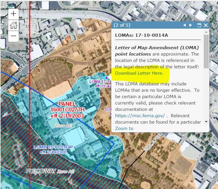
46 LOMCs
47 LOMCs
48 LOMCs Letter of Map Change (LOMC) is a general term used to refer to the several types of revisions & amendments to FEMA maps that can be accomplished by letter. They include: Letter of Map Amendment (LOMA), Letter of Map Revision (LOMR), & Letter of Map Revision based on Fill (LOMR-F).
49 LOMAs A Letter of Map Amendment (LOMA) is an official amendment, by letter, to an effective NFIP map. A LOMA establishes a property s location in relation to the Special Flood Hazard Area (SFHA). LOMAs are usually issued because a property has been inadvertently mapped as being in the floodplain, but is actually on natural high ground above the base flood elevation.
50 LOMRs A Letter of Map Revision (LOMR) is FEMA's modification to an effective FIRM, or Flood Boundary and Floodway Map (FBFM), or both. LOMRs are generally based on the implementation of physical measures that affect the hydrologic or hydraulic characteristics of a flooding source & thus result in the modification of the existing regulatory floodway, the effective BFEs, or the SFHA. The LOMR officially revises the FIRM or FBFM, & sometimes the Flood Insurance Study (FIS) report, & when appropriate, includes a description of the modifications. The LOMR is generally accompanied by an annotated copy of the affected portions of the FIRM, FBFM, or FIS report
51 LOMR-Fs A Letter of Map Revision Based on Fill (LOMR-F) is FEMA's modification of the Special Flood Hazard Area (SFHA) shown on the Flood Insurance Rate Map (FIRM) based on the placement of fill in the floodplain, but outside the existing regulatory floodway.

52 LOMCs (LOMA, LOMR-F, etc.)
53 LOMCs Because a LOMA officially amends the effective NFIP map, it is a public record that the community must maintain. All LOMCs should be noted on the community's master flood map & filed by panel number (or address) in an accessible location.

54 IDWR

55 IDWR

56 IDWR

57 IDWR

58 FEMA Idaho Effective Flood Maps
59 FEMA Idaho Effective Flood Maps
60 FEMA Idaho Effective Flood Maps
61 NFIP Insurance The NFIP offers the following maximum limits for most flood insurance policies: Building coverage can typically insure residential building's structural elements up to $250,000, or non-residential building at up to $500,000. Replacement coverage may be available for single-family, primary residences.
62 NFIP Building Property coverage Insured building & its foundation. Electrical & plumbing systems. Central air-conditioning equipment, furnaces, & water heaters. Refrigerators, cooking stoves, & built-in appliances (dishwashers). Permanently installed carpeting over an unfinished floor. Permanently installed paneling, wallboard, bookcases, & cabinets. Window blinds. Detached garages (up to 10% of Building Property coverage); detached buildings (other than garages) require a separate Building Property policy. Debris removal.
63 NFIP - Personal Property coverage Contents coverage must be purchased separately Personal belongings (clothing, furniture, & electronics) Curtains. Portable & window air conditioners. Portable microwave ovens & portable dishwashers. Carpets not included in building coverage. Clothes washers & dryers. Food freezers & the food in them. Certain valuable items such as original artwork & furs (up to $2,500).
64 NFIP What is NOT insured Damage caused by moisture, mildew, or mold that could have been avoided by the property owner. Currency, precious metals, & valuable papers (stock certificates). Property & belongings outside of a building (trees, plants, wells, septic systems, walks, decks, patios, fences, seawalls, hot tubs, & swimming pools). Living expenses such as temporary housing. Financial losses caused by business interruption or loss of use of insured property. Most self-propelled vehicles such as cars, including their parts.
65 NFIP Idaho Claims in 2017 Total claims January 1 to July 31: 199 Total dollars paid: $1,751, Largest claim value: $130, Claims still active/open: 54 Average Claim payment: $12,081.77
66 NFIP ID Claims 1978 to 7/31/2017 Total number of claims since 1978: 959 Total dollars paid: $7,408, Average claim value: $7,725.14

67 Hurricane Irene, Aurora, NC

68 Hurricane Irene, Aurora, NC

69 Not insurable by the NFIP

70 Protecting a home from flood in ID

71 Protecting a home from flood in ID
72 Questions? Thank You!
National Flood Insurance Program. Summary of Coverage
 National Flood Insurance Program Summary of Coverage FEMA F-679 / November 2012 This document was prepared by the National Flood Insurance Program (NFIP) to help you understand your flood insurance policy.
Summary of Your Flood Insurance Coverage
 Summary of Your Flood Insurance Coverage National Flood Insurancee (888) 900-0404 4885 North Wickham Rd Suite 105 Melbourne, FL 32940 Summary of Your Flood Insurance Coverage What is a Flood? A flood is
Questions about the National Flood Insurance Program
 Questions about the National Flood Insurance Program Federal Emergency Management Agency (FEMA) Questions and Answers What is the National Flood Insurance Program (NFIP)? The NFIP is a Federal program
Disaster Related Real Estate Issues. By Barry T. Bassis. Collecting Information
 Disaster Related Real Estate Issues By Barry T. Bassis Collecting Information When a disaster strikes, such as Superstorm Sandy, it may damage or even destroy homes and the surrounding property. The first
FLOODPLAIN FAQ s. Last Update: June 2017
 FLOODPLAIN FAQ s Last Update: June 2017 What does FEMA stand for? Federal Emergency Management Agency - the operation of FEMA is to lead America to prepare for, prevent, respond to, and recover from disasters.
National Flood Insurance Program (NFIP) for Real Estate Professionals
 for Real Estate Professionals") National Flood Insurance Program (NFIP) for Real Estate Professionals 1 Joshua Oyer, CFM Outreach Specialist NFIP State Coordinator s Office at the Texas Water Development Board 2 Outline Introduction
National Flood Insurance Program (NFIP) for Real Estate Professionals 1 Joshua Oyer, CFM Outreach Specialist NFIP State Coordinator s Office at the Texas Water Development Board 2 Outline Introduction
Floodplain Management 101. Mississippi Emergency Management Agency Floodplain Management Bureau
 Floodplain Management 101 Mississippi Emergency Management Agency Floodplain Management Bureau Stafford Act The Stafford Disaster Relief and Emergency Assistance Act (Stafford Act) (Public Law 100-707)
FLOOD INSURANCE APPLICATION, PART 1 (OF 2) IMPORTANT PLEASE PRINT OR TYPE; ENTER DATES AS MM/DD/YYYY.
 IMPORTANT PLEASE PRINT OR TYPE; ENTER DATES AS MM/DD/YYYY.") Make checks payable to: Wright National Flood Insurance Company P.O. Box 33003 St. Petersburg, FL 33733-8003 Phone (800) 323-8841 FLOOD INSURANCE APPLICATION, PART 1 (OF 2) IMPORTANT PLEASE PRINT OR TYPE;
Make checks payable to: Wright National Flood Insurance Company P.O. Box 33003 St. Petersburg, FL 33733-8003 Phone (800) 323-8841 FLOOD INSURANCE APPLICATION, PART 1 (OF 2) IMPORTANT PLEASE PRINT OR TYPE;
Using GISWeb to Determine Your Property s Flood Zone
 Using GISWeb to Determine Your Property s Flood Zone 1. In a new browser window, go to http://www.co.santacruz.ca.us/departments/geographicinformationsystemsgis.aspx 2. Click on GISWeb - GIS Mapping Application
FREQUENTLY ASKED QUESTION ABOUT FLOODPLAINS Michigan Department of Environmental Quality
 FREQUENTLY ASKED QUESTION ABOUT FLOODPLAINS Michigan Department of Environmental Quality WHAT IS A FLOOD? The National Flood Insurance Program defines a flood as a general and temporary condition of partial
Flood Insurance for Local Officials and Floodplain Managers. What Every Community Official Needs to Know About Flood Insurance
 Flood Insurance for Local Officials and Floodplain Managers What Every Community Official Needs to Know About Flood Insurance Illinois Association for Floodplain and Stormwater Management 2011 Annual Conference
JAXGIS FEMA Flood Hazard Mapping -- Frequently Asked Questions
 Flood Hazard Zone Designations Summary Zones starting with the letter 'A' (for instance, Zone A, Zone AE, Zone AH, Zone AO) denote a Special Flood Hazard Area, which can also be thought of as the 100-year
Enough about me! Topics Covered
 About Me Worked in land surveying since 1997 Employed by the City of Orlando since 2006 City of Orlando City Surveyor since February 2015 Certified Floodplain Manager since 2015 Florida Licensed Surveyor,
NFIP Mapping Issues. Wendy Lathrop, PLS, CFM. Cadastral Consulting, LLC
 NFIP Mapping Issues Cadastral Consulting, LLC NFIP Basic Objectives: Reduce the exposure to flood damages through the use of minimum standards for the placement and design of structures located in flood
Floodplain Management 101: UNIT II. Maps & Flood Insurance Studies
 Floodplain Management 101: UNIT II Maps & Flood Insurance Studies Who is ASFPM? ASFPM stands for the Association of State Floodplain Managers A national organization of floodplain management professionals
Article 23-6 FLOODPLAIN DISTRICT
 AMENDING THE CODE OF THE CITY OF PITTSFIELD CHAPTER 23, ZONING ORDINANCE SECTION I That the Code of the City of Pittsfield, Chapter 23, Article 23-6 Floodplain District, shall be replaced with the following:
Federal Emergency Management Agency
 Page 1 of 4 Issue Date: October 2, 2017 Effective Date: October 2, 2017 Case No.: 17-09-2731P LOMR-APP Federal Emergency Management Agency Washington, D.C. 20472 LETTER OF MAP REVISION DETERMINATION DOCUMENT
COLLIER COUNTY FLOODPLAIN MANAGEMENT
 COLLIER COUNTY FLOODPLAIN MANAGEMENT FREQUENTLY ASKED QUESTIONS The following information is based on common questions from the public. If you have a specific question or need further information, please
N F I P P o s t F l o o d W e b i n a r f o r A g e n t s N F I P P o s t F l o o d W e b i n a r f o r A g e n t s
 1 2 1 3 4 2 Overview 5 TOPICS Overview Flood Insurance and Disaster Assistance The Claims Process Common Coverage Issues Appeals Process Increased Cost of Compliance (ICC) Impact of Biggert Waters 2012
Requirements for Construction on Properties in the Special Flood Hazard Area (SFHA)
") Requirements for Construction on Properties in the Special Flood Hazard Area (SFHA) Rev 010915 The website for the IDNR to request the EFARA (Electronic Floodplain Analysis/Regulatory Assessment is found
Requirements for Construction on Properties in the Special Flood Hazard Area (SFHA) Rev 010915 The website for the IDNR to request the EFARA (Electronic Floodplain Analysis/Regulatory Assessment is found
ORDINANCE NO. 246 FLOOD DAMAGE PREVENTION ORDINANCE STATUTORY AUTHORIZATION, FINDINGS OF FACT, PURPOSE, AND OBJECTIVES
 ORDINANCE NO. 246 FLOOD DAMAGE PREVENTION ORDINANCE Article I. Section A. STATUTORY AUTHORIZATION, FINDINGS OF FACT, PURPOSE, AND OBJECTIVES Statutory Authority The Legislature of the State of Idaho, pursuant
Herkimer County, New York Flood Hazard Mapping Status Report for Property Owners
 Herkimer County, New York Flood Hazard Mapping Status Report for Property Owners Herkimer County, New York Flood Hazard Mapping Status Report for Property Owners FLOOD INSURANCE Who Should Purchase Flood
Door County Floodplain Program Informational Meeting
 Door County Floodplain Program Informational Meeting Door County Land Use Services Department Wisconsin Department of Natural Resources January 15, 2018 Floodplain = Land affected by flood event with a
a) Ensure public safety through reducing the threats to life and personal injury.
 Ensure public safety through reducing the threats to life and personal injury.") SECTION VII: FLOODPLAIN DISTRICT 7-1 Statement Of Purpose The purposes of the Floodplain District are to: a) Ensure public safety through reducing the threats to life and personal injury. b) Eliminate
SECTION VII: FLOODPLAIN DISTRICT 7-1 Statement Of Purpose The purposes of the Floodplain District are to: a) Ensure public safety through reducing the threats to life and personal injury. b) Eliminate
MT-1 Basics: A Comprehensive Overview of LOMAs and Discussion of Common Application Setbacks
 MT-1 Basics: A Comprehensive Overview of LOMAs and Discussion of Common Application Setbacks Introduction: Terminology MT-1s vs. MT-2s LOMAs vs. LOMRs What is a LOMC? Letters of Map Change (LOMCs) MT-1s
Key Fundamentals of Flood Insurance in the NFIP!
 a Welcome to Key Fundamentals of Flood Insurance in the NFIP! A Before and After approach for Housing Counselors Presented by: 1 Before the Flood Presenter Melanie Graham After the Flood Presenter Erin
THE FEDERAL EMERGENCY MANAGEMENT AGENCY. Letters of Map Change Kristen Martinenza, P.E., CFM FEMA Region IV
 THE FEDERAL EMERGENCY MANAGEMENT AGENCY Letters of Map Change Presented by: Kristen Martinenza, P.E., CFM FEMA Region IV 1 NATIONAL FLOOD INSURANCE ACT OF 1968 At the start of the program, there was not
TOWN OF TUNBRIDGE FLOOD HAZARD AREA ORDINANCE March 18, UPDATE June 17, 2014
 TOWN OF TUNBRIDGE FLOOD HAZARD AREA ORDINANCE March 18,1998 - UPDATE June 17, 2014 1.0 STATUTORY AUTHORIZATION 1.1 To effect the purposes of 10 V.S.A., Chapter 32, and in accord with the Vermont Planning
Federal Emergency Management Agency
 Page 1 of 4 Issue Date: September 7, 2012 Effective Date: January 22, 2013 DETERMINATION DOCUMENT COMMUNITY COMMUNITY AND REVISION INFORMATION City of Lubbock Lubbock County Texas PROJECT DESCRIPTION CHANNELIZATION
SECTION 9: MAPS AND DATA
 SECTION 9: MAPS AND DATA Contents 9.1. NFIP Maps and Data... 9-2 9.1.1. Adopting and enforcing NFIP floodplain maps and data... 9-2 9.1.2. Adopting and enforcing more restrictive data... 9-2 9.1.3. Annexations...
Preliminary DFIRM Community Coordination (PDCC) Meeting Gilchrist & Levy Counties, FL. April 30, 2015
 Meeting Gilchrist & Levy Counties, FL. April 30, 2015") Preliminary DFIRM Community Coordination (PDCC) Meeting Gilchrist & Levy Counties, FL April 30, 2015 Agenda 1. Introductions 2. Study Process and Timeline 3. Overview of Preliminary Products 4. Overview
Preliminary DFIRM Community Coordination (PDCC) Meeting Gilchrist & Levy Counties, FL April 30, 2015 Agenda 1. Introductions 2. Study Process and Timeline 3. Overview of Preliminary Products 4. Overview
FLOOD - THE WATER IS RISING AND SO ARE THE RATES! SPONSORED BY
 FLOOD - THE WATER IS RISING AND SO ARE THE RATES! SPONSORED BY Flood Insurance The Water is Rising & So Are the Rates!!! Michael C. D Orlando, CIC, LIA, CPIA Insurance Training & Consulting Services 11
Durham County Preliminary Flood Hazard Data Public Meeting. July 28, 2016
 Durham County Preliminary Flood Hazard Data Public Meeting July 28, 2016 Why Are We Here New flood hazard data has been released as Preliminary for Durham County Statutory Due Process for review/comments
ATTACHMENT 1. Amendments to Chapter 18.20, Definitions Area of shallow flooding Area of special flood hazard
 Amendments to Chapter 18.20, Definitions 18.20.206 Area of shallow flooding Area of shallow flooding means a designated AO, or AH, AR/AO, AR/AH, or VO Zone on the a community's flood insurance rate map
Abington Township Public Meeting
 Abington Township Public Meeting Flood Insurance Rate Map Update March 23, 2016 1 Meeting Agenda and Format Provide residents/property owners of Abington Township with information about the map update,
History of Floodplain Management in Ascension Parish
 History of Floodplain Management in Ascension Parish presented by: Kara Moree Floodplain Coordinator February 6, 2012 Floodplain 101 Floodplain 101 Base or 1% Flood: A flood having a 1% chance of being
If you have any questions or concerns please give us a call at , or Walter Jenkins at (ext 300).
.") FLORIDA ZONE SERVICES Flood Insurance and Zone Consulting 461 SE 3 rd Terrace Pompano Beach, FL 33060 Phone 954-290-7420 bspencer@florida-floodzone.com March 6, 2014 Dear Pebblebrook II Homeowner: We informing
FLORIDA ZONE SERVICES Flood Insurance and Zone Consulting 461 SE 3 rd Terrace Pompano Beach, FL 33060 Phone 954-290-7420 bspencer@florida-floodzone.com March 6, 2014 Dear Pebblebrook II Homeowner: We informing
Appendix D - Floodplain Documents
 City of Aspen Urban Runoff Management Plan Appendix D - Floodplain Documents 1. Floodplain Development Permit 2. Elevation Certificate and Instructions 3. Floodproofing Certificate for Non-Residential
10526 Bermuda Isle Dr. Tampa, FL 33647
 Flood Analysis Memo Property Address 10526 Bermuda Isle Dr. In Partnership with: ** This property is NOT within a high-risk flood zone ** 10526 Bermuda Isle Dr. BFE = 35 ft This property is located in
Federal Emergency Management Agency
 Page 1 of 5 Issue Date: October 16, 2014 Effective Date: March 2, 2015 Case No.: 14-09-2279P LOMR-APP Federal Emergency Management Agency Washington, D.C. 20472 LETTER OF MAP REVISION DETERMINATION DOCUMENT
Taylor County, Florida Community Coordination and Outreach (CCO) Meeting
 Meeting") Taylor County, Florida Community Coordination and Outreach (CCO) Meeting Suwannee River Water Management District April 26, 2017 11:00AM to 12:00PM Taylor County Administration Building, 201 E. Green Street,
Taylor County, Florida Community Coordination and Outreach (CCO) Meeting Suwannee River Water Management District April 26, 2017 11:00AM to 12:00PM Taylor County Administration Building, 201 E. Green Street,
Federal Emergency Management Agency
 Page 1 of 5 Issue Date: April 2, 2015 DETERMINATION DOCUMENT COMMUNITY AND REVISION INFORMATION PROJECT DESCRIPTION BASIS OF REQUEST Ventura County California NO PROJECT UPDATE COMMUNITY (Unincorporated
Federal Emergency Management Agency
 Page 1 of 5 Issue Date: July 27, 2012 Effective Date: December 10, 2012 Case No.: 11-06-4512P Follows Conditional Case No.: 06-06-B789R LOMR-APP Federal Emergency Management Agency Washington, D.C. 20472
FEMA Elevation Certificates and Hydrostatic Venting Requirements
 FEMA Elevation Certificates and Hydrostatic Venting Requirements Tennessee Association of Floodplain Managers Conference Gatlinburg, TN July 30 August 2, 2013 1 What is the National Flood Insurance Program
Kevin Wagner Maryland Department of the Environment
 Kevin Wagner Maryland Department of the Environment Topics Overview of the National Flood Insurance Program (NFIP) Mapping Regulations Insurance Mitigation Community Rating System (CRS) Questions Know
10526 Bermuda Isle Dr. Tampa, FL 33647
 Flood Analysis Memo Property Address In Partnership with: ** This property is NOT within a high-risk flood zone ** This property is located in a FEMA low-risk zone designated as Zone X - an area of minimal
Maryland Model Floodplain Management Ordinance (May, 2014) MODEL NOTES
 MODEL NOTES") Maryland Model Floodplain Management Ordinance (May, 2014) MODEL NOTES The model floodplain management ordinance that most Maryland communities have used as the basis for their regulations since the early
Maryland Model Floodplain Management Ordinance (May, 2014) MODEL NOTES The model floodplain management ordinance that most Maryland communities have used as the basis for their regulations since the early
REGION X FLOOD DAMAGE PREVENTION ORDINANCE WASHINGTON MODEL (REVISED 5/13/2004)
") REGION X FLOOD DAMAGE PREVENTION ORDINANCE WASHINGTON MODEL (REVISED 5/13/2004) Close to 300 towns, cities, counties, and tribes within the State of Washington participate in the National Flood Insurance
REGION X FLOOD DAMAGE PREVENTION ORDINANCE WASHINGTON MODEL (REVISED 5/13/2004) Close to 300 towns, cities, counties, and tribes within the State of Washington participate in the National Flood Insurance
Federal Emergency Management Agency
 Page 1 of 6 Issue Date: September 27, 2010 Effective Date: February 14, 2011 Follows Conditional Case No.: 08-08-0873R DETERMINATION DOCUMENT COMMUNITY AND REVISION INFORMATION PROJECT DESCRIPTION BASIS
Gail Moldovan-Trujillo, ACSR,CPIW Hagan Hamilton Insurance 2012 NFIP Agency of the year Flood Insurance Specialist & Consultant
 Gail Moldovan-Trujillo, ACSR,CPIW Hagan Hamilton Insurance 2012 NFIP Agency of the year Flood Insurance Specialist & Consultant Flood Insurance regulations continue to change at a very rapid pace, therefore
Federal Emergency Management Agency
 Page 1 of 4 Issue Date: April 26, 2013 DETERMINATION DOCUMENT COMMUNITY AND REVISION INFORMATION PROJECT DESCRIPTION BASIS OF REQUEST City of Coppell Dallas County Texas FILL HYDRAULIC ANALYSIS NEW TOPOGRAPHIC
Floodplain Development Permit Application
 Floodplain Development Permit Application **All construction will also require a building permit** This is an application packet for a Floodplain Development Permit. Certain sections are to be completed
Frequently Asked Questions and Answers Concerning Flood Insurance
 Frequently Asked Questions and Answers Concerning Flood Insurance Sources Used: (1) www.floodsmart.gov (2) National Flood Insurance Program, Answers to Questions about the NFIP, FEMA F-084/ March 2011.
Introduction to the National Flood Insurance Program: A Guide for Coastal Property Owners MAINE BEACHES CONFERENCE 2017
 Introduction to the National Flood Insurance Program: A Guide for Coastal Property Owners MAINE BEACHES CONFERENCE 2017 SUE BAKER, CFM STATE NFIP COORDINATOR MAINE DEPT OF AGRICULTURE, CONSERVATION & FORESTRY
Floodplain Development Permit Application
 Floodplain Development Permit Application City of Jonesboro, AR This is an application packet for a Floodplain Development Permit. Certain sections are to be completed by the Applicant, and certain sections
CITY OF FORT PIERCE BUILDING DEPARTMENT
 CITY OF FORT PIERCE BUILDING DEPARTMENT APPLICATION FOR DETERMINATION OF SUBSTANTIAL IMPROVEMENT This is a request for determination by the City s Floodplain Administrator as to whether or not the project
Flood Analysis Memo. 629 Orangewood Dr. Dunedin, FL BFE = 21 ft
 Flood Analysis Memo Property Address 629 Orangewood Dr. In Partnership with: ** This property is NOT within a high-risk flood zone ** 629 Orangewood Dr. BFE = 21 ft This property is located in the FEMA
Pinellas County Flood Map Information Service & Real Estate Disclosure Program Training January 26, 2017 COMMON FLOODPLAIN ACRONYMS
 FEMA ASFPM BFE CAV Pinellas County Flood Map Information Service & Real Estate Disclosure Program Training COMMON FLOODPLAIN ACRONYMS Federal Emergency Management Agency Association of State Floodplain
17.13 FLOOD DAMAGE PREVENTION ORDINANCE. Article I. Statutory Authorization, Findings of Fact, Purpose, and Methods
 17.13 FLOOD DAMAGE PREVENTION ORDINANCE Article I Statutory Authorization, Findings of Fact, Purpose, and Methods 17.1301 Statutory Authorization. The Legislature of the State of South Dakota has in (statutes)
MOKAN CRS Users Group Activity 310, Elevation Certificates Packet
 http://mokan.stormsmart.org/ MOKAN CRS Users Group Activity 310, Elevation Certificates Packet This packet includes the following documents to be used as applicable to your community: EC checklist EC correction
LOCAL OFFICIALS MEETING Lake Wausau Physical Map Revision MARATHON COUNTY, WISCONSIN FEBRUARY 9, 2017
 LOCAL OFFICIALS MEETING Lake Wausau Physical Map Revision MARATHON COUNTY, WISCONSIN FEBRUARY 9, 2017 Welcome & Introduction Michelle Staff Floodplain Management Policy Coordinator, WDNR Michelle.Staff@Wisconsin.gov
Federal Emergency Management Agency
 Page 1 of 4 Issue Date: August 1, 2012 Effective Date: December 13, 2012 Case No.: 12-06-0595P LOMR-APP Washington, D.C. 20472 LETTER OF MAP REVISION DETERMINATION DOCUMENT COMMUNITY AND REVISION INFORMATION
CONTRA COSTA COUNTY FLOODPLAIN MANAGEMENT PROGRAM
 CONTRA COSTA COUNTY FLOODPLAIN MANAGEMENT PROGRAM Answers to Commonly Asked Questions and A Guide for Residential Construction Within Special Flood Hazard Areas Revised February 2015 Introduction Ninety
City of St. Augustine. Floodplain Management Higher Standards Information
 City of St. Augustine Floodplain Management Higher Standards Information There are different regulations that communities can use to help protect existing and future development and natural floodplain
INSTRUCTIONS FOR COMPLETING THE APPLICATION FORMS FOR CONDITIONAL LETTERS OF MAP REVISION AND LETTERS OF MAP REVISION
 INSTRUCTIONS FOR COMPLETING THE APPLICATION FORMS FOR CONDITIONAL LETTERS OF MAP REVISION AND LETTERS OF MAP REVISION GENERAL In 1968, the U.S. Congress passed the National Flood Insurance Act, which created
FLOOD DAMAGE PREVENTION RULES
 60.3(d) FLOOD DAMAGE PREVENTION RULES ARTICLE 1 STATUTORY AUTHORIZATION, FINDINGS OF FACT, PURPOSE AND METHODS SECTION A. STATUTORY AUTHORIZATION The Legislature of the State of Texas adopted the Flood
Oak Island 1999 Hurricane Floyd
 Oak Island 1999 Hurricane Floyd Topics to be Discussed What is a flood zone Flood zones in Oak Island Special Flood Hazard Areas (SFHA) Flood insurance Base Flood Elevations (BFEs) Building in flood zones
National Flood Insurance Program
 National Flood Insurance Program FEMA ELEVATION CERTIFICATES PA Surveyor Training Presented by Thomas F. Smith, PE, PLS January 22, 2018 1 FEMA Region III Mitigation Division Floodplain Management & Insurance
Revisions to National Flood Insurance Program Maps
 MT-1 Revisions to National Flood Insurance Program Maps Application Forms and Instructions for Conditional and Final Letters of Map Amendment and Letters of Map Revision Based on Fill FEMA Form 81-87 Series
FLOODPLAIN DEVELOPMENT VARIANCE APPLICATION PACKET
 FLOODPLAIN DEVELOPMENT VARIANCE APPLICATION PACKET Sutter County Water Resources Department 1130 Civic Center Boulevard Yuba City, California, 95993 (530) 822-7400 Floodplain management regulations cannot
Floodplain Management Annual Conference Atlanta, Georgia April 2017
 Floodplain Management 2017 Annual Conference Atlanta, Georgia April 2017 Floodplain Mapping and Flood Zones Zone Deisgnations: Zone A: No base flood elevations have been determined it is an approximated
ORDINANCE NO A FLOOD DAMAGE PREVENTION ORDINANCE
 ORDINANCE NO. 692-14 A FLOOD DAMAGE PREVENTION ORDINANCE WHEREAS, for a community to participate in the National Flood Insurance Program NFIP, it must adopt and enforce floodplain management regulations
Welcome to The NFIP s Basic Agent Tutorial: Key Fundamentals of Flood Insurance
 a Welcome to The NFIP s Basic Agent Tutorial: Key Fundamentals of Flood Insurance Focused on flood insurance basics for insurance professionals (Part 2) 1 Here s our AGENDA Section 1 Introduction and General
Federal Emergency Management Agency
 Page 1 of 3 COMMUNITY AND MAP PANEL INFORMATION COMMUNITY CITY OF MARGATE CITY, ATLANTIC COUNTY, NEW JERSEY LEGAL PROPERTY DESCRIPTION A parcel of land, as described in Deed recorded in Book 4826, page
210 W Canal Dr Palm Harbor, FL 34684
 Flood Analysis Memo Property Address In Partnership with: ** This property is within a high risk flood zone ** BFE = 6 ft This property is located in the FEMA designated high-risk zone, Zone AE - an area
Federal Emergency Management Agency
 Page 1 of 6 Issue Date: May 13 2016 Case No.: Follows Conditional Case No.: 14-05-0595R DETERMINATION DOCUMENT COMMUNITY AND REVISION INFORMATION PROECT DESCRIPTION BASIS OF REQUEST COMMUNITY Village of
Chapter 4: National Flood and Insurance Guide. 4 CE Hours. Learning objectives. Introduction. By:Valerie Wohl
 Chapter 4: National Flood and Insurance Guide 4 CE Hours By:Valerie Wohl Learning objectives List three myths about flood insurance that keep property owners from purchasing coverage. Explain the role
Chapter 5 Floodplain Management
 Chapter 5 Floodplain Management Contents 1.0 Introduction... 1 2.0 Floodplain Management and Regulation... 1 2.1 City Code... 1 2.2 Floodplain Management... 1 2.3 Level of Flood Protection... 2 2.3.1 Standard
North Carolina Department of Public Safety Emergency Management Risk Management
 North Carolina Department of Public Safety Emergency Management Risk Management Roy Cooper, Governor Erik A. Hooks, Secretary Michael A. Sprayberry, Director INSTRUCTIONS FOR COMPLETING THE NORTH CAROLINA
NESHOBA COUNTY, MISSISSIPPI FLOOD DAMAGE PREVENTION ORDINANCE
 NESHOBA COUNTY, MISSISSIPPI FLOOD DAMAGE PREVENTION ORDINANCE January 22, 2019 NESHOBA COUNTY, MISSISSIPPI FLOOD DAMAGE PREVENTION ORDINANCE TABLE OF CONTENTS ARTICLE 1. STATUTORY AUTHORIZATION, FINDINGS
Appendix B. A Comparison of the Minimum NFIP Requirements and the CRS
 A Comparison of the Minimum s and the CRS The Community Rating System provides credits for exceeding the minimum requirements of the National Flood Insurance Program (NFIP). Many local officials are not
DELTA COUNTY FLOOD DAMAGE PREVENTION REGULATIONS CERTIFIED BY THE. Delta County Planning Commission September 26, 2013 ADOPTED BY THE
 DELTA COUNTY FLOOD DAMAGE PREVENTION REGULATIONS CERTIFIED BY THE Delta County Planning Commission September 26, 2013 ADOPTED BY THE Board of Delta County Commissioners December 9, 2013 REVISED BY THE
Guidelines and Specifications for Flood Hazard Mapping Partners. Introduction
 Introduction INT.1 Purpose and Scope of Document The Federal Emergency Management Agency (FEMA), as the agency responsible for administration of the National Flood Insurance Program (NFIP), conducts flood
What Was Updated in 2004 in Hennepin Countywide Maps?
 What Was Updated in 2004 in Hennepin Countywide Maps? Combined the city and township maps into one countywide index Done by USACE Mainly digital capture of old floodplain boundaries; some spots with shifts
Federal Emergency Management Agency
 Page 1 of 6 Issue Date: October 24, 2012 Effective Date: March 7, 2013 Case No.: LOMR-APP DETERMINATION DOCUMENT COMMUNITY AND REVISION INFORMATION PROJECT DESCRIPTION BASIS OF REQUEST City of Lubbock
YOLO COUNTY FLOODPLAIN MANAGEMENT PROGRAM
 YOLO COUNTY FLOODPLAIN MANAGEMENT PROGRAM Answers to Commonly Asked Questions and A Guide for Residential Construction Within Special Flood Hazard Areas The automatic entry and exit of flood water); Or
INTRODUCTION AND GENERAL RULES. Welcome to The NFIP s Basic Agent Tutorial: Key Fundamentals of Flood Insurance. Section 1
 a Welcome to The NFIP s Basic Agent Tutorial: Key Fundamentals of Flood Insurance Focused on flood insurance basics for insurance professionals 1 Section 1 INTRODUCTION AND GENERAL RULES 2 1 Here s our
Michigan Department of Environmental Quality 525 West Allegan Street Lansing, MI (517)
") FLOODPLAIN MANAGEMENT IN MICHIGAN 2002 John Engler, Governor Russell J. Harding, Director Michigan Department of Environmental Quality 525 West Allegan Street Lansing, MI 48909 (517) 373-1170 www.michigan.gov/deq
FLOODPLAIN MANAGEMENT IN MICHIGAN 2002 John Engler, Governor Russell J. Harding, Director Michigan Department of Environmental Quality 525 West Allegan Street Lansing, MI 48909 (517) 373-1170 www.michigan.gov/deq
Federal Emergency Management Agency
 Federal Emergency Management Agency Washington, D. C. 24 72 December 29, 214 CERTIFIED MAIL RETURN RECEIPT REQUESTED The Honorable Gary Wescott Mayor, City of Stevens Point 1515 Strongs A venue Stevens
AMENDMENTS TO CHAPTER 50: FLOODPLAIN DEVELOPMENT
 AMENDMENTS TO CHAPTER 50: FLOODPLAIN DEVELOPMENT PART I: 2018 FLOOD MAP IMPLEMENTATION PART II: STRATEGIES TO IMPROVE THE CITY S COMMUNITY RATING SYSTEM SCORE NATIONAL FLOOD INSURANCE PROGRAM (NFIP) CREATED
CITIZEN POTAWATOMI NATION PUBLIC CONSERVATION AND ENVIROMENTAL PROTECTION ACT TITLE 35
 CITIZEN POTAWATOMI NATION PUBLIC CONSERVATION AND ENVIROMENTAL PROTECTION ACT TITLE 35 CHAPTER SECTION 1 ESTABLISHMENT OF THE DEPARTMENT OF ENVIRONMENTAL PROTECTION Establishment 101 Required Reporting
F E M A Mapping Changes. FEMA Mapping Changes. National Flood Insurance Program
 FEMA Mapping Changes National Flood Insurance Program 1 Welcome to FEMA Mapping Changes! We will get started in a few minutes. Meanwhile, let s perform a warm up exercise. 2 1 Training Agenda Section 1-
Nassau County, Florida Consultation Coordination Officer (CCO) Meeting. February 24, 2016 Fernandina Beach, Florida
 Meeting. February 24, 2016 Fernandina Beach, Florida") Nassau County, Florida Consultation Coordination Officer (CCO) Meeting February 24, 2016 Fernandina Beach, Florida Agenda Introductions Coastal Study Update Study Process and Timeline Flood Insurance Implications
Nassau County, Florida Consultation Coordination Officer (CCO) Meeting February 24, 2016 Fernandina Beach, Florida Agenda Introductions Coastal Study Update Study Process and Timeline Flood Insurance Implications
Commercial Risks & the NFIP Know the Facts (Intermediate) Student s Guide
 Student s Guide") Commercial Risks & the NFIP Know the Facts (Intermediate) Student s Guide Provided by: Kalispell, Montana This training workbook and attendant materials are designed to provide producers with the basic
Commercial Risks & the NFIP Know the Facts (Intermediate) Student s Guide Provided by: Kalispell, Montana This training workbook and attendant materials are designed to provide producers with the basic
TOWN OF KENT, CT PLANNING AND ZONING COMMISSION
 TOWN OF KENT, CT PLANNING AND ZONING COMMISSION FLOOD PLAIN MANAGEMENT REGULATIONS Whereas, Congress has determined that a National Flood Insurance Program would alleviate personal hardships and economic
Commonwealth Schools of Insurance, Inc.
 Commonwealth Schools of Insurance P.O. Box 22414, Louisville, KY 40252-0414 502.425.5987 FAX 502.429.0755 E-mail: info@commonwealthschools.com INSTRUCTIONS TO COMPLETE THE CONTINUING EDUCATION COURSE Thank
Model B E. Flood Damage Prevention Ordinance 4/11
 Model B E Flood Damage Prevention Ordinance 4/11 The following information is provided to assist you in developing an ordinance that will comply with the minimum participating criteria of the National
Flood: How to Protect Your Business from a Natural Disaster
 Flood: How to Protect Your Business from a Natural Disaster Speakers: Greg Bates, Managing Consultant, Global Risk Consultants (GRC) Frank Francone, Manager, Insurance & Risk Services, General Growth Properties
Federal Emergency Management Agency
 Page 1 of 5 Issue Date: October 28, 2009 Follows Conditional Case No.: 08-08-0612R DETERMINATION DOCUMENT COMMUNITY AND REVISION INFORMATION PROJECT DESCRIPTION BASIS OF REQUEST COMMUNITY Lincoln County
Federal Emergency Management Agency
 Page 1 of 4 Issue Date: April 29, 2011 DETERMINATION DOCUMENT COMMUNITY COMMUNITY AND REVISION INFORMATION City of Simi Valley Ventura County California PROJECT DESCRIPTION NO PROJECT BASIS OF REQUEST