Durham County Preliminary Flood Hazard Data Public Meeting. July 28, 2016
|
|
|
- Horace Hancock
- 6 years ago
- Views:
Transcription


1 Durham County Preliminary Flood Hazard Data Public Meeting July 28, 2016
2 Why Are We Here New flood hazard data has been released as Preliminary for Durham County Statutory Due Process for review/comments on new data Develop an understanding for both the process and the results of updating flood hazard data Local government hosts this meeting to identify resources that can help you find answers to your questions
3 PURPOSE OF NFIP To make flood insurance available To identify floodplains and areas at risk of flooding To provide standards, guidance, and a framework to help communities manage floodplains
4 DEFINITIONS Digital Flood Insurance Rate Map (DFIRM) A digitally-produced FIRM, whether viewed in hardcopy or in digital form All FIRMs produced by the North Carolina Floodplain Mapping Program are DFIRMs Flood Insurance Study (FIS) Details the examination, evaluation, and determination of flood hazard areas FIRMs are part of the FIS Base Flood Elevation (BFE) Water Surface Elevation for the 1% annual-chance or 100-yr flood Used as the basis for most floodplain development requirements and flood insurance rating
5 DEFINITIONS Special Flood Hazard Area (SFHA) The 1% annual-chance floodplain, where NFIP regulations must be enforced by the community as a condition of participation in the NFIP Floodway (and Non-Encroachment Area) The portion of the SFHA, including the channel of a river or other watercourse, that must be reserved (free of development) in order to allow the discharge of the base flood without increasing the water-surface elevation more than one foot at any point along the stream
6 MAPPING PROCESS Scoping (AKA, Discovery) Base Map Acquisition Map Production Post- Preliminary Processing
7 POST-PRELIMINARY PROCESSING Preliminary flood hazard data (FIS/FIRM) for Durham County released on March 31, Day Appeal/Protest Period: July 6 October 3, 2016 Meeting with Public Officials: May 26, 2015 Public Participation Meeting: July 28, 2016 Opportunity for public to view, comment on, and ask questions about the new flood hazard data Letter of Final Determination: FEMA determines flood hazard data is official for flood insurance rating and floodplain management applications
8 POST-PRELIMINARY PROCESSING Local Responsibilities Work with Citizens to understand preliminary data Review preliminary data for errors and missing information within the 90-day review period Forward appeals and/or comments from the public and local officials to the state and FEMA Adopt Ordinances Changes
9 Durham County Revision


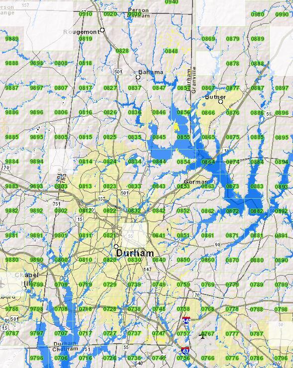
10 Streams Studied in Durham County
11 Durham County: By the numbers Item Quantity Detailed Study miles Limited Detailed Study 54.1 miles Updated Discharges (flows) miles Printed Cross Sections 2,568 Special Flood Hazard Area 52 sq miles County Area 298 sq miles Effective maps for Durham County are dated May 2, 2006, February 2, 2007, April 16, 2007, June 4, 2007, August 2, 2007, and May 16, 2008.

12 Durham County Floodplains

13 Newly Studied Stream: Detailed Study New Study Area Panel 0739 Panel 0749 Northeast Creek Northeast Creek Tributary 1 Stream was previously mapped as Zone A
 Panel 0848 Rocky Creek")
14 New Boundary Mapping: 1% Future Conditions Expanded Boundary Mapping Rocky Creek (into Flat River) Panel 0848 Rocky Creek Tributary 1

15 Effective Mapping: Detailed Study Stirrup Iron Creek Panel 9314 Panel 9313

16 2015 Detailed vs. Effective Mapping Stirrup Iron Creek Panel 9314 Panel 9313 SFHA Change Decrease in SFHA due to new detailed modeling


17 2015 Detailed vs. Effective Mapping Panel 0727 Northeast Creek Tributary C SFHA Change Decrease in SFHA due to new detailed modeling

18 2015 Detailed vs. Effective Mapping Panel 0822 South Ellerbe Creek Limit of Study Extended SFHA Change Increase in SFHA due to new detailed modeling

19 Effective Mapping: Detailed Study South Ellerbe Creek Stirrup Iron Creek Panel 9314 Panel 9313 Panel 0822
 Floodway Change")
20 2014 Detailed vs. Effective Mapping (Floodway Difference) Floodway Change Decrease in Floodway due to new detailed modeling
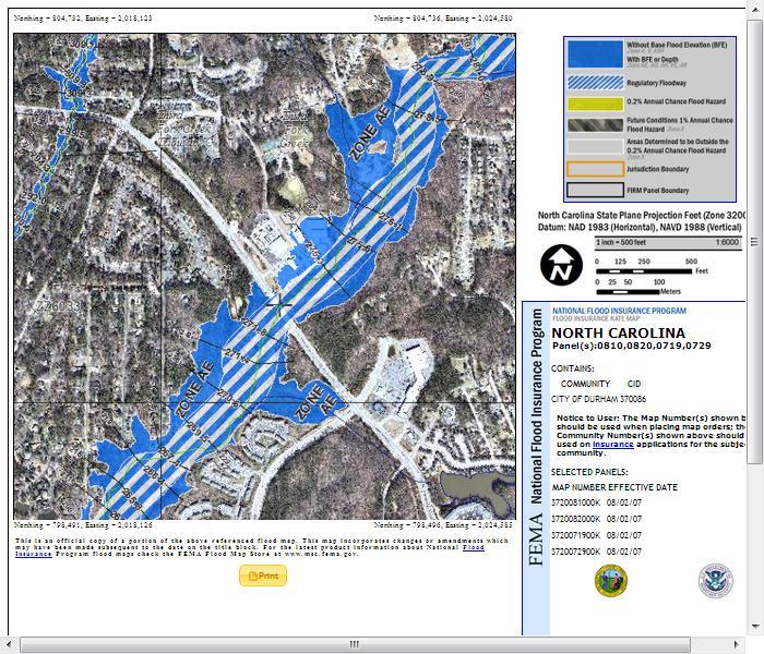
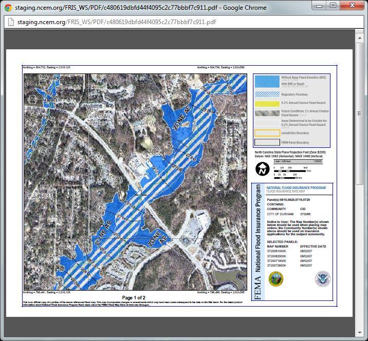
21 2015 FIRM with Identifiers Zone AE 100-yr Cross Section Number 1% Future Condition Zone Floodway Regulatory Elevation

22 2015 FIRM with Identifiers Benchmark Stream Name Community Information
23 Accessing Digital Flood Hazard Data from the Flood Risk Information System (FRIS)
24 Flood Data in Digital Database Format Key Elements of the data include: Zone designations Base Flood Elevations Depth of water elevations on buildings Print-on-demand available Flood Information Study (FIS) Flood Insurance Rate Maps (FIRMs) FRIS shows updated Panels with Green Borders; effective panels shaded out in the Preliminary view

25 FRIS FIRM Map Symbology

26 FRIS FIRM Map Symbology

27 FRIS Data Downloads
28

29 Effective view vs Preliminary
 Click LEGEND Green = Decrease Red =")
30 Changes Since Last FIRM Click LAYERS on the Tool bar (for Map Contents) Click LEGEND Green = Decrease Red = Increase

31 Changes Since Last FIRM

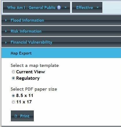
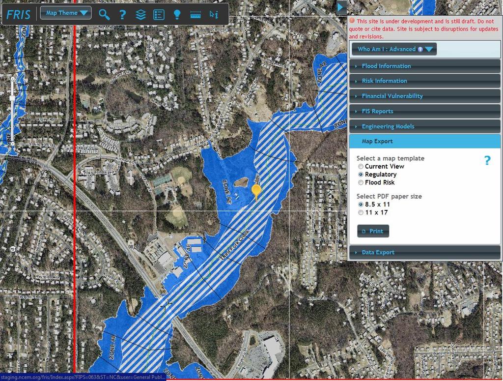
32 FRIS Display View/Print/Map Export

33 FRIS Produce a FIRMETTE


34
35 POST-PRELIMINARY PROCESSING Appeals An appeal is a formal objection to new or revised BFEs, SFHA and Floodway boundaries in the preliminary data that is submitted during the 90- day appeal period Appeals are based on data that show proposed BFEs to be scientifically or technically incorrect See Expanded Appeals Process Fact Sheet for additional Information and online resources
36 Expanded Appeals Process (New) Due Process required for all proposed changes in the SFHA with possible insurance impacts; now includes: Changes to BFE Modification of any SFHA boundary Zone designations Floodway boundaries (increases and decreases in extent) Scientific and/or Technical data still required as part of an Appeal
37 POST-PRELIMINARY PROCESSING Comments A comment is a formal objection to the information in the FIS Report and/or shown on the FIRM panels not related to BFEs Comments generally involve concerns regarding the corporate limits, Extraterritorial Jurisdiction (ETJ) boundaries, and road names or locations
38 POST-PRELIMINARY PROCESSING Appeals & Comments SUBMIT TO: John Dorman, Director NCFMP 4218 Mail Service Center Raleigh, NC (919) Kristen Martinenza, P.E., CFM FEMA-R4 (Hollins Building) 3003 Chamblee-Tucker Road Atlanta, GA (770) The appeal period for Durham County is July 6 October 3, 2016
39 POST-PRELIMINARY PROCESSING Effective Date Changes to the preliminary flood data [i.e. flood zones, boundaries and base flood elevations] will not affect flood insurance policies until the effective date of the FIS This date will be established by FEMA through the Letter of Final Determination (LFD) once submitted appeals and comments are evaluated and resolved
40 USE OF PRELIMINARY DATA For areas currently in Zones X (Shaded or Unshaded): Use of Preliminary data is not required: May be used in cases were the structure or development will be located in Zone AE For areas currently in Zone AE, where Higher BFEs/wider floodways encourage use of new data Lower BFEs/narrower floodways- apply Effective data until LFD is issued; beneficial flood insurance for lowering risk If communities wish to enforce more stringent data, they must adopt the Preliminary data

41 USE OF PRELIMINARY DATA Best Available Data Fact Sheet Available online at sheets.htm Provides information as to what data may be used immediately from the preliminary FIS Report as best available data for Zone A areas (BFEs, floodway/nonencroachment area data)
42 IMPACT ON LOMCs Community receives Summary of Map Actions (SOMA) listing all LOMAs, LOMRs, and LOMR-Fs issued since last FIS effective date SOMA online at - Preliminary SOMA shows how each LOMC was affected by the preliminary flood hazard data Possible Actions: Incorporated (if LOMC is map-able) Superseded (if flood hazard was restudied and ground elevation is below new BFE) Revalidated (if LOMC is unaffected by map revision but is too small to show on FIRM) Revalidation letters are sent to affected communities prior to the new FIS effective date and will become effective the following day
43 IMPACT OF NEW MAPS ON FLOOD INSURANCE RATES
44 SAMPLE FLOOD INSURANCE RATES Zone X $1,402* Annual Zone Flood AE Insurance Premiums** $1,679 Zone VE $3,854 Rates are as of April 2016 and are subject to change * If the structure has not had previous flood claims or received previous Federal Disaster Assistance payments, it might qualify for a Preferred Risk Policy in Zone X with the lowest possible rate of $349 for $100,000 building/$40,000 contents coverage Flood insurance coverage of $100,000 building/$25,000 contents on an NFIP compliant structure (free of obstruction/enclosure) with a policy deductible of $1,000.
45 SAMPLE FLOOD INSURANCE RATES Flood Insurance Premiums When Structure is Built ABOVE the BFE* Lowest Floor Elevation Rates Effective April 2016 AE Zone VE Zone BFE $1,679 $3,854 BFE + 1 ft. $849 $3,066 BFE + 2 ft. $552 $2,269 BFE + 3 ft. $444 $1,680 BFE + 4 ft. $423 $1,499 * Flood insurance coverage of $100,000 building/$25,000 contents on an NFIP compliant structure (free of obstruction/enclosure) with a policy deductible of $1,000.
46 SAMPLE FLOOD INSURANCE RATES Flood Insurance Premiums When Structure is Built BELOW the BFE* Lowest Floor Elevation Rates Effective April 2016 AE Zone VE Zone BFE $1,679 $3,854 BFE - 1 ft. $3,945 $4,707 BFE - 2 ft. Submit for Rate $5,803 BFE - 3 ft. Submit for Rate $7,116 BFE - 4 ft. Submit for Rate Submit for Rate * Flood insurance coverage of $100,000 building/$25,000 contents on an NFIP compliant structure (free of obstruction/enclosure) with a policy deductible of $1,000.
47 LOCAL FREEBOARD & NFIP STATISTICS Community Joined NFIP (Regular Program) Freeboard Policies Insurance in Force Durham County 2/15/ feet 215 $53,330,900 City of Durham 1/17/ feet 1,090 $259,460,400
48 IMPACT ON FLOOD INSURANCE RATES AS A RESULT OF NEW LEGISLATION Highlights of the Homeowners Flood Insurance Affordability Act of 2014 (HFIAA)
49 HFIAA Provisions Rate-increase limitations Limit increases for individual premiums to 18% of premium Limit increases for average rate classes to 15% The annual surcharge and Federal Policy Fee are not included in the rate calculation and could result in the total amount charged to the policyholder to increase more than 18% Deductibles Maximum residential deductible limits are increased from $5,000 to $10,000.
50 What s Changing for Pre-FIRM Subsidized rates to be phased out Non-primary residences Business properties Severe repetitive loss properties (1-4 residences), and properties where claims payments exceed fair market value New policies to be issued at full-risk rates After a lapse in insurance coverage Properties for which there was a refusal to mitigate
51 What s Changing for Pre-FIRM Pre-FIRM Non-Primary Residence Policies Includes vacation homes, secondary residences, and rental properties 25% annual increase at policy renewal until premium reaches full-risk rate Pre-FIRM Business Policies Future rates will increase by 25% per year until premium reaches full-risk rate until FEMA can separate businesses from other non-residential structures
52 HFIAA Provisions Federal Reserve Fund The Federal Reserve Fund was implemented in 2013 to help cover costs when claims exceed the annual premium collected by the NFIP. On April 1, 2015, the Federal Reserve Fund assessment was added to additional policies. Policy 2014 Fee 2015 Fee 2016 Fee Preferred Risk Policy (PRP) 0% 10% 15% Property Newly Mapped into SFHA 0% 15% 15% All other policies 5% 15% 15%
53 HFIAA Provisions Federal Policy Fee The Federal Policy Fees have increased for all. Federal Policy Fee for Preferred Risk Policies is $25 ($22 in April 2015). Federal Policy Fee for all other policies is $50 ($45 in April 2015).
54 HFIAA Provisions All policies get a new annual surcharge based on occupancy $25 for primary residential: single-family and individual condominium units $250 for non-residential properties, nonprimary residential properties, and multifamily residential Surcharges would be deposited in the NFIP Reserve Fund, which was established to ensure funds are available for meeting the expected future obligations of the NFIP
55 HFIAA Provisions Properties Newly Mapped in SFHA Eligible to receive a Preferred Risk Policy for 1 year after the maps become effective. However, the Federal Policy Fee will be $50 rather than $25. Rates at renewal will increase no more than 18% each year. Grandfathering remains a cost-saving option for policyholders when new maps show their structure in a higher risk area (increased BFE or Zone AE to Zone VE).
56 Grandfathering When the FIRM changes, the NFIP provides a lower-cost flood insurance rating option refer to as grandfathering. Grandfathering is available to property owners who: Have flood insurance policies in effect when the new flood maps become effective and maintain continuous coverage; OR Have built in compliance with the FIRM in effect at the time of construction.
57 IMPORTANT DATES Preliminary Period: Current, in progress Appeal Period: July 6 October3, 2016 Letter of Final Determination TBD
58 QUESTIONS?
Preliminary DFIRM Community Coordination (PDCC) Meeting Gilchrist & Levy Counties, FL. April 30, 2015
 Meeting Gilchrist & Levy Counties, FL. April 30, 2015") Preliminary DFIRM Community Coordination (PDCC) Meeting Gilchrist & Levy Counties, FL April 30, 2015 Agenda 1. Introductions 2. Study Process and Timeline 3. Overview of Preliminary Products 4. Overview
Preliminary DFIRM Community Coordination (PDCC) Meeting Gilchrist & Levy Counties, FL April 30, 2015 Agenda 1. Introductions 2. Study Process and Timeline 3. Overview of Preliminary Products 4. Overview
Taylor County, Florida Community Coordination and Outreach (CCO) Meeting
 Meeting") Taylor County, Florida Community Coordination and Outreach (CCO) Meeting Suwannee River Water Management District April 26, 2017 11:00AM to 12:00PM Taylor County Administration Building, 201 E. Green Street,
Taylor County, Florida Community Coordination and Outreach (CCO) Meeting Suwannee River Water Management District April 26, 2017 11:00AM to 12:00PM Taylor County Administration Building, 201 E. Green Street,
Bullitt County, Kentucky Preliminary DFIRM Community Open House. October 8, 2014 Shepherdsville, Kentucky
 Bullitt County, Kentucky Preliminary DFIRM Community Open House October 8, 2014 Shepherdsville, Kentucky Meeting Agenda Introductions Overview of Preliminary DFIRMs Overview of Map Appeal Process Questions
Nassau County, Florida Consultation Coordination Officer (CCO) Meeting. February 24, 2016 Fernandina Beach, Florida
 Meeting. February 24, 2016 Fernandina Beach, Florida") Nassau County, Florida Consultation Coordination Officer (CCO) Meeting February 24, 2016 Fernandina Beach, Florida Agenda Introductions Coastal Study Update Study Process and Timeline Flood Insurance Implications
Nassau County, Florida Consultation Coordination Officer (CCO) Meeting February 24, 2016 Fernandina Beach, Florida Agenda Introductions Coastal Study Update Study Process and Timeline Flood Insurance Implications
Kevin Wagner Maryland Department of the Environment
 Kevin Wagner Maryland Department of the Environment Topics Overview of the National Flood Insurance Program (NFIP) Mapping Regulations Insurance Mitigation Community Rating System (CRS) Questions Know
Floodplain Management 101: UNIT II. Maps & Flood Insurance Studies
 Floodplain Management 101: UNIT II Maps & Flood Insurance Studies Who is ASFPM? ASFPM stands for the Association of State Floodplain Managers A national organization of floodplain management professionals
What Was Updated in 2004 in Hennepin Countywide Maps?
 What Was Updated in 2004 in Hennepin Countywide Maps? Combined the city and township maps into one countywide index Done by USACE Mainly digital capture of old floodplain boundaries; some spots with shifts
St. Johns County, Florida Consultation Coordination Officer (CCO) Meeting. August 31, 2016 St. Augustine, Florida
 Meeting. August 31, 2016 St. Augustine, Florida") St. Johns County, Florida Consultation Coordination Officer (CCO) Meeting August 31, 2016 St. Augustine, Florida Agenda Introductions Coastal Study Update Study Process and Timeline Flood Insurance Implications
St. Johns County, Florida Consultation Coordination Officer (CCO) Meeting August 31, 2016 St. Augustine, Florida Agenda Introductions Coastal Study Update Study Process and Timeline Flood Insurance Implications
Floodplain Management 101. Mississippi Emergency Management Agency Floodplain Management Bureau
 Floodplain Management 101 Mississippi Emergency Management Agency Floodplain Management Bureau Stafford Act The Stafford Disaster Relief and Emergency Assistance Act (Stafford Act) (Public Law 100-707)
Herkimer County, New York Flood Hazard Mapping Status Report for Property Owners
 Herkimer County, New York Flood Hazard Mapping Status Report for Property Owners Herkimer County, New York Flood Hazard Mapping Status Report for Property Owners FLOOD INSURANCE Who Should Purchase Flood
LOCAL OFFICIALS MEETING Lake Wausau Physical Map Revision MARATHON COUNTY, WISCONSIN FEBRUARY 9, 2017
 LOCAL OFFICIALS MEETING Lake Wausau Physical Map Revision MARATHON COUNTY, WISCONSIN FEBRUARY 9, 2017 Welcome & Introduction Michelle Staff Floodplain Management Policy Coordinator, WDNR Michelle.Staff@Wisconsin.gov
Door County Floodplain Program Informational Meeting
 Door County Floodplain Program Informational Meeting Door County Land Use Services Department Wisconsin Department of Natural Resources January 15, 2018 Floodplain = Land affected by flood event with a
National Flood Insurance Program Changes Effective April 1, 2016
 National Flood Insurance Program Changes Effective April 1, 2016 Beginning April 1, 2016, the National Flood Insurance Program (NFIP) will begin implementing additional flood insurance program changes
Abington Township Public Meeting
 Abington Township Public Meeting Flood Insurance Rate Map Update March 23, 2016 1 Meeting Agenda and Format Provide residents/property owners of Abington Township with information about the map update,
N.C. Floodplain Mapping Program
 N.C. Floodplain Mapping Program Current Status and Update April 23, 2018 NCFMP Program Objectives Purpose: Develop, Maintain, and Disseminate current, accurate, digital flood hazard data for all of NC,
Bucks County, PA Flood Risk Review Meeting. November 2014
 Bucks County, PA Flood Risk Review Meeting November 2014 Agenda for Today Risk MAP Program overview Overview of non-regulatory Flood Risk Products and datasets Discuss mitigation action Technical overview
Using GISWeb to Determine Your Property s Flood Zone
 Using GISWeb to Determine Your Property s Flood Zone 1. In a new browser window, go to http://www.co.santacruz.ca.us/departments/geographicinformationsystemsgis.aspx 2. Click on GISWeb - GIS Mapping Application
Federal Emergency Management Agency
 Page 1 of 5 Issue Date: July 27, 2012 Effective Date: December 10, 2012 Case No.: 11-06-4512P Follows Conditional Case No.: 06-06-B789R LOMR-APP Federal Emergency Management Agency Washington, D.C. 20472
Federal Emergency Management Agency
 Page 1 of 4 Issue Date: February 14, 2013 Effective Date: June 28, 2013 DETERMINATION DOCUMENT COMMUNITY AND REVISION INFORMATION City of Sunny Isles Beach Miami-Dade County Florida PROJECT DESCRIPTION
NFIP Mapping Issues. Wendy Lathrop, PLS, CFM. Cadastral Consulting, LLC
 NFIP Mapping Issues Cadastral Consulting, LLC NFIP Basic Objectives: Reduce the exposure to flood damages through the use of minimum standards for the placement and design of structures located in flood
Using Non-Regulatory RiskMAP Products in Floodplain Management. Ferrin Affleck, PE, CFM, Water Resources Engineer Project Manager Atkins
 Using Non-Regulatory RiskMAP Products in Floodplain Management Ferrin Affleck, PE, CFM, Water Resources Engineer Project Manager Atkins 1 Goal of this Presentation Inform Peak interest Stimulate creativity
Duval County, Florida Consultation Coordination Officer (CCO) Meeting. January 25, 2017 Jacksonville, Florida
 Meeting. January 25, 2017 Jacksonville, Florida") Duval County, Florida Consultation Coordination Officer (CCO) Meeting January 25, 2017 Jacksonville, Florida Agenda Introductions Coastal Study Update Study Process and Timeline Flood Insurance Implications
Duval County, Florida Consultation Coordination Officer (CCO) Meeting January 25, 2017 Jacksonville, Florida Agenda Introductions Coastal Study Update Study Process and Timeline Flood Insurance Implications
Federal Emergency Management Agency
 Page 1 of 3 COMMUNITY AND MAP PANEL INFORMATION COMMUNITY CITY OF MARGATE CITY, ATLANTIC COUNTY, NEW JERSEY LEGAL PROPERTY DESCRIPTION A parcel of land, as described in Deed recorded in Book 4826, page
Federal Emergency Management Agency
 Page 1 of 4 Issue Date: August 1, 2012 Effective Date: December 13, 2012 Case No.: 12-06-0595P LOMR-APP Washington, D.C. 20472 LETTER OF MAP REVISION DETERMINATION DOCUMENT COMMUNITY AND REVISION INFORMATION
Federal Emergency Management Agency
 Page 1 of 4 Issue Date: April 26, 2013 DETERMINATION DOCUMENT COMMUNITY AND REVISION INFORMATION PROJECT DESCRIPTION BASIS OF REQUEST City of Coppell Dallas County Texas FILL HYDRAULIC ANALYSIS NEW TOPOGRAPHIC
210 W Canal Dr Palm Harbor, FL 34684
 Flood Analysis Memo Property Address In Partnership with: ** This property is within a high risk flood zone ** BFE = 6 ft This property is located in the FEMA designated high-risk zone, Zone AE - an area
Skagit County Flood Insurance Study Update. Ryan Ike, CFM FEMA Region 10
 Skagit County Flood Insurance Study Update Ryan Ike, CFM FEMA Region 10 Skagit County Flood Insurance Study Process Overview Process, Schedule, & Deliverables Base Flood Elevations, Modeling, & Levees
10526 Bermuda Isle Dr. Tampa, FL 33647
 Flood Analysis Memo Property Address In Partnership with: ** This property is NOT within a high-risk flood zone ** This property is located in a FEMA low-risk zone designated as Zone X - an area of minimal
10526 Bermuda Isle Dr. Tampa, FL 33647
 Flood Analysis Memo Property Address 10526 Bermuda Isle Dr. In Partnership with: ** This property is NOT within a high-risk flood zone ** 10526 Bermuda Isle Dr. BFE = 35 ft This property is located in
YAVAPAI COUNTY FLOOD CONTROL DISTRICT STAKEHOLDER WORKSHOP. March 30 th & 31 st, 2015
 YAVAPAI COUNTY FLOOD CONTROL DISTRICT STAKEHOLDER WORKSHOP March 30 th & 31 st, 2015 1 Floods Happen In Yavapai County September 1983 Northwest Prescott Area: - Willow Creek - Bottleneck Wash - Granite
REAL ESTATE FLOOD DISCLOSURE PROGRAM & FLOOD MAP INFORMATION SERVICES
 REAL ESTATE FLOOD DISCLOSURE PROGRAM & FLOOD MAP INFORMATION SERVICES Agenda 10:30-12:00 Flood Disclosure Program 12:00-12:30 Lunch 12:30-1:30 Flood Map Service Center Lisa Foster, CFM, Floodplain Coordinator
Community Officials Meeting. Plumas and Sierra County Physical Map Revision
 Community Officials Meeting Plumas and Sierra County Physical Map Revision March 6, 2014 Agenda Introductions/Sign In Project Scope Sierra Valley Flood Study (Plumas and Sierra Counties) North Yuba River
Changes Coming to the National Flood Insurance Program What to Expect. Impact of changes to the NFIP under Section 205 of the Biggert-Waters Act
 Changes Coming to the National Flood Insurance Program What to Expect Impact of changes to the NFIP under Section 205 of the Biggert-Waters Act Flood Risk Flood risks and the costs of flooding Weather
Middlesex County Timeline
 Community Coordination Meeting for Middlesex County, Connecticut Risk MAP Study November 9, 2011 Agenda Welcome and Introductions Project Timeline Coastal Flood Hazard Analysis Recap Public Review and
Federal Emergency Management Agency
 Page 1 of 4 Issue Date: October 2, 2017 Effective Date: October 2, 2017 Case No.: 17-09-2731P LOMR-APP Federal Emergency Management Agency Washington, D.C. 20472 LETTER OF MAP REVISION DETERMINATION DOCUMENT
F E M A Mapping Changes. FEMA Mapping Changes. National Flood Insurance Program
 FEMA Mapping Changes National Flood Insurance Program 1 Welcome to FEMA Mapping Changes! We will get started in a few minutes. Meanwhile, let s perform a warm up exercise. 2 1 Training Agenda Section 1-
Federal Emergency Management Agency
 Page 1 of 6 Issue Date: May 13 2016 Case No.: Follows Conditional Case No.: 14-05-0595R DETERMINATION DOCUMENT COMMUNITY AND REVISION INFORMATION PROECT DESCRIPTION BASIS OF REQUEST COMMUNITY Village of
Federal Emergency Management Agency
 Page 1 of 5 Issue Date: October 16, 2014 Effective Date: March 2, 2015 Case No.: 14-09-2279P LOMR-APP Federal Emergency Management Agency Washington, D.C. 20472 LETTER OF MAP REVISION DETERMINATION DOCUMENT
Federal Emergency Management Agency
 Page 1 of 5 Issue Date: April 2, 2015 DETERMINATION DOCUMENT COMMUNITY AND REVISION INFORMATION PROJECT DESCRIPTION BASIS OF REQUEST Ventura County California NO PROJECT UPDATE COMMUNITY (Unincorporated
Requirements for Construction on Properties in the Special Flood Hazard Area (SFHA)
") Requirements for Construction on Properties in the Special Flood Hazard Area (SFHA) Rev 010915 The website for the IDNR to request the EFARA (Electronic Floodplain Analysis/Regulatory Assessment is found
Requirements for Construction on Properties in the Special Flood Hazard Area (SFHA) Rev 010915 The website for the IDNR to request the EFARA (Electronic Floodplain Analysis/Regulatory Assessment is found
Federal Emergency Management Agency
 Page 1 of 4 Issue Date: April 11, 2013 Case No.: DETERMINATION DOCUMENT COMMUNITY AND REVISION INFORMATION PROJECT DESCRIPTION BASIS OF REQUEST Town Of Stratford Fairfield County Connecticut NO PROJECT
FLOODPLAIN FAQ s. Last Update: June 2017
 FLOODPLAIN FAQ s Last Update: June 2017 What does FEMA stand for? Federal Emergency Management Agency - the operation of FEMA is to lead America to prepare for, prevent, respond to, and recover from disasters.
Federal Emergency Management Agency
 Page 1 of 4 Issue Date: September 7, 2012 Effective Date: January 22, 2013 DETERMINATION DOCUMENT COMMUNITY COMMUNITY AND REVISION INFORMATION City of Lubbock Lubbock County Texas PROJECT DESCRIPTION CHANNELIZATION
ASFPM Partnerships for Statewide Mitigation Actions. Alicia Williams GIS and HMP Section Manager, Amec Foster Wheeler June 2016
 ASFPM Partnerships for Statewide Mitigation Actions Alicia Williams GIS and HMP Section Manager, Amec Foster Wheeler June 2016 Summary The Concept Leveraging Existing Data and Partnerships to reduce risk
REAL ESTATE FLOOD DISCLOSURE PROGRAM & FLOOD MAP INFORMATION SERVICES
 REAL ESTATE FLOOD DISCLOSURE PROGRAM & FLOOD MAP INFORMATION SERVICES Lisa Foster, CFM, Floodplain Coordinator ldfoster@pinellascounty.org January 26, 2018 Why are you here? Save your clients money on
History of Floodplain Management in Ascension Parish
 History of Floodplain Management in Ascension Parish presented by: Kara Moree Floodplain Coordinator February 6, 2012 Floodplain 101 Floodplain 101 Base or 1% Flood: A flood having a 1% chance of being
Flood Map Revisions. Town of Nags Head Public Information and Input Session. December 14, 2016, 6 pm
 Flood Map Revisions Town of Nags Head Public Information and Input Session December 14, 2016, 6 pm Flood Map Revisions New preliminary flood maps released for Dare County June 30, 2016 www.nagsheadnc.gov/floodmaps
Federal Emergency Management Agency
 Page 1 of 5 Issue Date: June 21, 2013 Follows Conditional Case No.: 04-06-A148R DETERMINATION DOCUMENT COMMUNITY COMMUNITY AND REVISION INFORMATION City of Irving Dallas County Texas FILL PROJECT DESCRIPTION
Impacts of Map Changes -Flood Insurance-
 Impacts of Map Changes -Flood Insurance- 1 Effective Dates Waiting Periods 30-day 1-day 0 day 2 Flood Zones Moderate- and Low-Risk B, C, X, Shaded X Over 35% of Arizona flood claims occur here High-Risk
BEING PREPARED FOR MAP CHANGES What to Know; What to Say National Flood Conference May 16, 2016
 BEING PREPARED FOR MAP CHANGES What to Know; What to Say National Flood Conference May 16, 2016 0 Discussion Topics Risk MAP Program Background Eric Simmons FEMA Region 9 Map Change Rating Options Edie
SECTION 9: MAPS AND DATA
 SECTION 9: MAPS AND DATA Contents 9.1. NFIP Maps and Data... 9-2 9.1.1. Adopting and enforcing NFIP floodplain maps and data... 9-2 9.1.2. Adopting and enforcing more restrictive data... 9-2 9.1.3. Annexations...
OTTAWA COUNTY AND SANDUSKY COUNTY COMMUNITY CONSULTATION OFFICERS (CCO) MEETING December 7, 2017
 MEETING December 7, 2017") OTTAWA COUNTY AND SANDUSKY COUNTY COMMUNITY CONSULTATION OFFICERS (CCO) MEETING December 7, 2017 TODAY S AGENDA The Value of Updated Flood Maps for Your Community Reviewing the Updated Flood Risk Data
OTTAWA COUNTY AND SANDUSKY COUNTY COMMUNITY CONSULTATION OFFICERS (CCO) MEETING December 7, 2017 TODAY S AGENDA The Value of Updated Flood Maps for Your Community Reviewing the Updated Flood Risk Data
Enough about me! Topics Covered
 About Me Worked in land surveying since 1997 Employed by the City of Orlando since 2006 City of Orlando City Surveyor since February 2015 Certified Floodplain Manager since 2015 Florida Licensed Surveyor,
Updates to Maine Coastal Flood Insurance Rate Maps (FIRM s): What a Local Official Should Know. Presented by: Steve Johnson, P.E.
: What a Local Official Should Know. Presented by: Steve Johnson, P.E.") Updates to Maine Coastal Flood Insurance Rate Maps (FIRM s): What a Local Official Should Know Presented by: Steve Johnson, P.E. Town Engineer October 4, 2018 Introduction Federal Emergency Management
Updates to Maine Coastal Flood Insurance Rate Maps (FIRM s): What a Local Official Should Know Presented by: Steve Johnson, P.E. Town Engineer October 4, 2018 Introduction Federal Emergency Management
Consultation Coordination Officer (CCO) Meeting
 Meeting") Consultation Coordination Officer (CCO) Meeting Middle Brazos Lake Whitney Physical Map Revision Hill and McLennan Counties FEMA Region 6 Agenda National Flood Insurance Program Purpose of the Meeting
Consultation Coordination Officer (CCO) Meeting Middle Brazos Lake Whitney Physical Map Revision Hill and McLennan Counties FEMA Region 6 Agenda National Flood Insurance Program Purpose of the Meeting
July 31, 2017 NFIP Flood Map Open House Flood Maps 101 Flood Mapping acronyms History of the NFIP Flood Mapping Updates Flood Insurance Fairhope,
 July 31, 2017 NFIP Flood Map Open House Flood Maps 101 Flood Mapping acronyms History of the NFIP Flood Mapping Updates Flood Insurance Fairhope, Alabama Flood Maps Fairhope Permitting Jurisdiction Coastal
Gail Moldovan-Trujillo, ACSR,CPIW Hagan Hamilton Insurance 2012 NFIP Agency of the year Flood Insurance Specialist & Consultant
 Gail Moldovan-Trujillo, ACSR,CPIW Hagan Hamilton Insurance 2012 NFIP Agency of the year Flood Insurance Specialist & Consultant Flood Insurance regulations continue to change at a very rapid pace, therefore
National Flood Insurance Program, Biggert-Waters 2012, and Homeowners Flood Insurance Affordability Act 2014
 National Flood Insurance Program, Biggert-Waters 2012, and Homeowners Flood Insurance Affordability Act 2014 Janice Mitchell, Insurance Specialist Floodplain Management and Insurance Branch FEMA Region
SUPERHERO!!! Elevation Certificate. You are about to go from SURVEYOR 2/18/2019
 Karol L. Grove Licensed Professional Surveyor Certified Floodplain Manager Elevation Certificate No longer the Animal it used to be When are they needed??? You are about to go from SURVEYOR to SUPERHERO!!!
If you have any questions or concerns please give us a call at , or Walter Jenkins at (ext 300).
.") FLORIDA FLOODZONE SERVICES Flood Insurance and Zone Consulting 461 SE 3 rd Terrace Pompano Beach, FL 33060 Phone 954-290-7420 bspencer@florida-floodzone.com March 15, 2010 Dear Portofino Lakes Homeowner:
FLORIDA FLOODZONE SERVICES Flood Insurance and Zone Consulting 461 SE 3 rd Terrace Pompano Beach, FL 33060 Phone 954-290-7420 bspencer@florida-floodzone.com March 15, 2010 Dear Portofino Lakes Homeowner:
Federal Emergency Management Agency
 Page 1 of 5 Issue Date: October 28, 2009 Follows Conditional Case No.: 08-08-0612R DETERMINATION DOCUMENT COMMUNITY AND REVISION INFORMATION PROJECT DESCRIPTION BASIS OF REQUEST COMMUNITY Lincoln County
THE FEDERAL EMERGENCY MANAGEMENT AGENCY. Letters of Map Change Kristen Martinenza, P.E., CFM FEMA Region IV
 THE FEDERAL EMERGENCY MANAGEMENT AGENCY Letters of Map Change Presented by: Kristen Martinenza, P.E., CFM FEMA Region IV 1 NATIONAL FLOOD INSURANCE ACT OF 1968 At the start of the program, there was not
Flood Risk Review (FRR) Meeting. Cumberland County, Pennsylvania Carlisle, Pennsylvania December 5, 2016
 Meeting. Cumberland County, Pennsylvania Carlisle, Pennsylvania December 5, 2016") Flood Risk Review (FRR) Meeting Cumberland County, Pennsylvania Carlisle, Pennsylvania December 5, 2016 Why are we here today? The Flood Insurance Study (FIS) report and Flood Insurance Rate Maps (FIRMs)
Flood Risk Review (FRR) Meeting Cumberland County, Pennsylvania Carlisle, Pennsylvania December 5, 2016 Why are we here today? The Flood Insurance Study (FIS) report and Flood Insurance Rate Maps (FIRMs)
Flood Analysis Memo. 629 Orangewood Dr. Dunedin, FL BFE = 21 ft
 Flood Analysis Memo Property Address 629 Orangewood Dr. In Partnership with: ** This property is NOT within a high-risk flood zone ** 629 Orangewood Dr. BFE = 21 ft This property is located in the FEMA
NFIP Overview Elevation Certificate Flood Insurance Rate Maps. By: Maureen O Shea, AICP, CFM State NFIP Coordinator
 NFIP Overview Elevation Certificate Flood Insurance Rate Maps By: Maureen O Shea, AICP, CFM State NFIP Coordinator Example of a flood failure Example of a flood failure Purposes of the NFIP Identify &
9/20/2016. Orange County Preliminary FIRM / Consultation Coordination Officer (CCO) Meeting
 Meeting") Orange County Preliminary FIRM / Consultation Coordination Officer (CCO) Meeting Open Pacific Coast Study September 21 and 22, 2016 1 Welcome and Introductions Preliminary FIRM / CCO Meeting Orange County
Orange County Preliminary FIRM / Consultation Coordination Officer (CCO) Meeting Open Pacific Coast Study September 21 and 22, 2016 1 Welcome and Introductions Preliminary FIRM / CCO Meeting Orange County
Federal Emergency Management Agency
 Page 1 of 6 Issue Date: October 24, 2012 Effective Date: March 7, 2013 Case No.: LOMR-APP DETERMINATION DOCUMENT COMMUNITY AND REVISION INFORMATION PROJECT DESCRIPTION BASIS OF REQUEST City of Lubbock
National Flood Insurance Program (NFIP) for Real Estate Professionals
 for Real Estate Professionals") National Flood Insurance Program (NFIP) for Real Estate Professionals 1 Joshua Oyer, CFM Outreach Specialist NFIP State Coordinator s Office at the Texas Water Development Board 2 Outline Introduction
National Flood Insurance Program (NFIP) for Real Estate Professionals 1 Joshua Oyer, CFM Outreach Specialist NFIP State Coordinator s Office at the Texas Water Development Board 2 Outline Introduction
Federal Emergency Management Agency
 Page 1 of 6 Issue Date: September 27, 2010 Effective Date: February 14, 2011 Follows Conditional Case No.: 08-08-0873R DETERMINATION DOCUMENT COMMUNITY AND REVISION INFORMATION PROJECT DESCRIPTION BASIS
Community Coordination Meeting Sagadahoc County, Maine
 Community Coordination Meeting Sagadahoc County, Maine Risk MAP Study April 2, 2014 Agenda Welcome and Introductions Project Timeline Flood Hazard Analysis Recap Flood Risk Products Action: Hazard Mitigation
Floodplain Management Annual Conference Atlanta, Georgia April 2017
 Floodplain Management 2017 Annual Conference Atlanta, Georgia April 2017 Floodplain Mapping and Flood Zones Zone Deisgnations: Zone A: No base flood elevations have been determined it is an approximated
National Flood Insurance Program and Biggert-Waters 2012
 National Flood Insurance Program and Biggert-Waters 2012 National Flood Insurance Program NFIP was created by Congress in 1968 Coverage underwritten by the Federal Government, administered by FEMA NFIP
COLLIER COUNTY FLOODPLAIN MANAGEMENT
 COLLIER COUNTY FLOODPLAIN MANAGEMENT FREQUENTLY ASKED QUESTIONS The following information is based on common questions from the public. If you have a specific question or need further information, please
Introduction to the National Flood Insurance Program: A Guide for Coastal Property Owners MAINE BEACHES CONFERENCE 2017
 Introduction to the National Flood Insurance Program: A Guide for Coastal Property Owners MAINE BEACHES CONFERENCE 2017 SUE BAKER, CFM STATE NFIP COORDINATOR MAINE DEPT OF AGRICULTURE, CONSERVATION & FORESTRY
Community Coordination Meeting. York County, Maine. Risk MAP Study
 Community Coordination Meeting York County, Maine Risk MAP Study January 9, 2014 Agenda Welcome and Introductions Project Timeline Flood Hazard Analysis Recap (Digital Conversion, Riverine and Coastal)
NFIP: October 2016 Updates and Community Decision Impacts on Individual Rates
 NFIP: October 2016 Updates and Community Decision Impacts on Individual Rates Carl Watts, Regional Liaison NFIP-iService, Region VI cwatts@nfip-iservice.com P: 405-257-9000 1 1 NFIP: Review and October
Federal Emergency Management Agency
 Page 1 of 4 Issue ate: May 18, 2012 Follows Conditional Case No.: 08-06-1597R ETERMINATION OCUMENT COMMUNITY AN REVISION INFORMATION PROJECT ESCRIPTION BASIS OF REQUEST COMMUNITY Harris County Texas (Unincorporated
NFIP Program Basics. KAMM Regional Training
 NFIP Program Basics KAMM Regional Training Floodplain 101 Homeowners insurance does not cover flood damage Approximately 25,000 flood insurance policies in KY According to BW12 analysis, approximately
THE $64,000 FLOOD INSURANCE BILL
 THE $64,000 FLOOD INSURANCE BILL GEORGIA ASSOCIATION OF FLOODPLAIN MANAGERS 9 TH ANNUAL TECHNICAL CONFERENCE Patrick Gervais, PE, CFM A CASE STUDY IN FLOOD INSURANCE This is a true story that happened
National Flood Insurance Program
 National Flood Insurance Program FEMA ELEVATION CERTIFICATES PA Surveyor Training Presented by Thomas F. Smith, PE, PLS January 22, 2018 1 FEMA Region III Mitigation Division Floodplain Management & Insurance
WAYNE COUNTY COMMUNITY CONSULTATION OFFICERS (CCO) MEETING. February 27, 2019
 MEETING. February 27, 2019") WAYNE COUNTY COMMUNITY CONSULTATION OFFICERS (CCO) MEETING February 27, 2019 TODAY S AGENDA Review the Updated Flood Risk Data for Your County Next Steps in the Map Adoption Process Understanding Flood
WAYNE COUNTY COMMUNITY CONSULTATION OFFICERS (CCO) MEETING February 27, 2019 TODAY S AGENDA Review the Updated Flood Risk Data for Your County Next Steps in the Map Adoption Process Understanding Flood
Cameron County, TX. Consultation Coordination Officer (CCO) Meeting. Please sign in (sheet at front of the room) Meeting will begin at 9:00
 Meeting. Please sign in (sheet at front of the room) Meeting will begin at 9:00") Cameron County, TX Consultation Coordination Officer (CCO) Meeting Please sign in (sheet at front of the room) Meeting will begin at 9:00 July 29, 2015 Lisa Jennings FEMA Region 6 Roles & Responsibilities
Cameron County, TX Consultation Coordination Officer (CCO) Meeting Please sign in (sheet at front of the room) Meeting will begin at 9:00 July 29, 2015 Lisa Jennings FEMA Region 6 Roles & Responsibilities
Kentucky Risk MAP It s not Map Mod II
 Kentucky Risk MAP It s not Map Mod II Risk Mapping Assessment and Planning Carey Johnson Kentucky Division of Water carey.johnson@ky.gov What is Risk MAP? Risk Mapping, Assessment, and Planning (Risk MAP)
Flood Insurance for Local Officials and Floodplain Managers. What Every Community Official Needs to Know About Flood Insurance
 Flood Insurance for Local Officials and Floodplain Managers What Every Community Official Needs to Know About Flood Insurance Illinois Association for Floodplain and Stormwater Management 2011 Annual Conference
National Flood Insurance Program Making Sense of April 2019 Changes
 National Flood Insurance Program Making Sense of April 2019 Changes Foreword The National Flood Insurance Program (NFIP) provides an important means for property owners to protect themselves financially
Martin County, Florida Consultation Coordination Officer (CCO) Meeting. March 22, 2018 Stuart, Florida
 Meeting. March 22, 2018 Stuart, Florida") Martin County, Florida Consultation Coordination Officer (CCO) Meeting March 22, 2018 Stuart, Florida Agenda Introductions Coastal Flood Risk Study Review Data Collected Storm Surge Modeling Overland Wave
Martin County, Florida Consultation Coordination Officer (CCO) Meeting March 22, 2018 Stuart, Florida Agenda Introductions Coastal Flood Risk Study Review Data Collected Storm Surge Modeling Overland Wave
National Flood Insurance Program
 National Flood Insurance Program A Discussion in Three Parts: The Nature of Flood Risk An Overview of the NFIP Impact of Recent Legislation (BW-12 & HFIAA-14) Nature of Flood Risk FLOODS ARE AN ACT OF
If you have any questions or concerns please give us a call at , or Walter Jenkins at (ext 300).
.") FLORIDA ZONE SERVICES Flood Insurance and Zone Consulting 461 SE 3 rd Terrace Pompano Beach, FL 33060 Phone 954-290-7420 bspencer@florida-floodzone.com March 6, 2014 Dear Pebblebrook II Homeowner: We informing
FLORIDA ZONE SERVICES Flood Insurance and Zone Consulting 461 SE 3 rd Terrace Pompano Beach, FL 33060 Phone 954-290-7420 bspencer@florida-floodzone.com March 6, 2014 Dear Pebblebrook II Homeowner: We informing
Key Fundamentals of Flood Insurance
 a Welcome to Key Fundamentals of Flood Insurance An entry-level approach for real estate professionals [Photo credit: Oliver Gruener] We will get started in a few minutes. Presented Meanwhile, by: let
CRISP COUNTY, GEORGIA AND INCORPORATED AREAS
 CRISP COUNTY, GEORGIA AND INCORPORATED AREAS Community Name Community Number ARABI, CITY OF 130514 CORDELE, CITY OF 130214 CRISP COUNTY (UNINCORPORATED AREAS) 130504 Crisp County EFFECTIVE: SEPTEMBER 25,
October 1, Write Your Own (WYO) Principal Coordinators and the National Flood Insurance Program (NFIP) Servicing Agent
 Principal Coordinators and the National Flood Insurance Program (NFIP) Servicing Agent") U.S. Department of Homeland Security Washington, D.C. 20472 October 1, 2015 MEMORANDUM FOR: Write Your Own (WYO) Principal Coordinators and the National Flood Insurance Program (NFIP) Servicing Agent FROM:
U.S. Department of Homeland Security Washington, D.C. 20472 October 1, 2015 MEMORANDUM FOR: Write Your Own (WYO) Principal Coordinators and the National Flood Insurance Program (NFIP) Servicing Agent FROM:
REAL ESTATE FLOOD DISCLOSURE PROGRAM & FLOOD MAP INFORMATION SERVICES
 REAL ESTATE FLOOD DISCLOSURE PROGRAM & FLOOD MAP INFORMATION SERVICES Lisa Foster, CFM, Floodplain Coordinator ldfoster@pinellascounty.org January 26, 2018 Why are you here? Save your clients money on
Changes to the National Flood Insurance Program What to Expect
 Changes to the National Flood Insurance Program What to Expect Impact of changes to the NFIP under Homeowner Flood Insurance Affordability Act of 2014 BW-12: What Changed Subsidies to be phased out Non-primary
North Carolina Department of Public Safety Emergency Management Risk Management
 North Carolina Department of Public Safety Emergency Management Risk Management Roy Cooper, Governor Erik A. Hooks, Secretary Michael A. Sprayberry, Director INSTRUCTIONS FOR COMPLETING THE NORTH CAROLINA
Federal Emergency Management Agency
 Federal Emergency Management Agency Washington, D. C. 24 72 December 29, 214 CERTIFIED MAIL RETURN RECEIPT REQUESTED The Honorable Gary Wescott Mayor, City of Stevens Point 1515 Strongs A venue Stevens
Federal Emergency Management Agency
 Page 1 of 4 Issue Date: November 16 2016 Effective Date: March 31 2017 Case No: 16-06-2056P LOMR-APP Follows Conditional Case No: 10-06-3320R Federal Emergency Management Agency Washington DC 20472 LETTER
Federal Emergency Management Agency
 age 1 of 4 Issue Date: April 16, 2013 Effective Date: August 30, 2013 DETERMINATION DOCUMENT COMMUNITY AND REVISION INFORMATION ROJECT DESCRITION BASIS OF REQUEST City of Naples Collier County Florida
Table 1: Federal, State and Local Government Rules applicable to LOMRs/CLOMRS submittal
 MnDNR LOMC Guide This document has been prepared by the Minnesota Department of Natural Resources floodplain staff and is intended to provide assistance with LOMR/CLOMR submittals. This information is
May 16th, FEMA Region I. MA Agents Association Live-Stream on May 16, 2017 AGENDA
 May 16th, 2017 FEMA Region I MA Agents Association Live-Stream on May 16, 2017 AGENDA 1. April 1, 2017 Changes 2. October 2017 Changes 3. Section 28 Clear Communications 4. Private Flood Insurance 5. Misc.
Changes to the National Flood Insurance Program: From Biggert to Grimm Waters. Click to edit Master title style. Click to edit Master subtitle style
 Changes to the National Flood Insurance Program: Click to edit Master title style From Biggert to Grimm Waters Click to edit Master subtitle style Thomas Ruppert Coastal Planning Specialist With thanks