GIS - Introduction and Sample Uses
|
|
|
- Charlene Skinner
- 6 years ago
- Views:
Transcription
1 PDHonline Course L145 (5 PDH) GIS - Introduction and Sample Uses Instructor: Jonathan Terry, P.L.S PDH Online PDH Center 5272 Meadow Estates Drive Fairfax, VA Phone & Fax: An Approved Continuing Education Provider
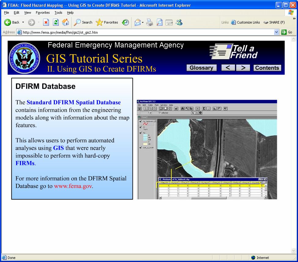
2 Welcome to: FEMAs GIS Tutorial Series (Tutorials I, II and III) Screen-captures of FEMA s well-thought-out and carefully presented tutorial on: GIS (Geographic Information Systems) TUTORIAL 2 OF 3 The tutorial series presents an introduction to GIS illustrated with FEMA s application of GIS in their MAP MODERNIZATION OBJECTIVES
3 Table of Contents Page Description of Content --- INTRODUCTION Title Slide and Learning Objectives 5 Introductory Slides and Note Regarding the Glossary Entries --- BACKGROUND FIRM Product 8 Modernizing DFIRMS --- DFIRM COMPONENTS Introduction 13 Base Map Specifications 14 Base Map Data 15 Flood Hazard Data --- COMPILATION PROCESS Introduction 16 Data Format 17 Map Projection IMPORTANT: The blue-text links in the course material and the GLOSSARY entries accessed through the pull-down menu provide significant benefits to those studying the live, on-line tutorial. For this reason, it is suggested that those using this hard-copy version of FEMA s GIS tutorial series make frequent reference to the GLOSSARY section at the end of each portion of the tutorial. For your convenience and ease of study, each of these three hard-copy files (a separate file covering each session of FEMA s 3-part GIS tutorial series) contains GLOSSARY entries from all three live tutorials. Both the course material and the quiz rely on frequent reference to these GLOSSARY entries. --- Contents Continue on Following Page ---
4 Table of Contents (continued) Page Description of Content --- FINALIZING THE MAP The Cartographic Process --- QUALITY CONTROL QC Software and Hardcopy FIRM Review --- DFIRM DATABASE Analyses using GIS that was not possible with hard-copy FIRM product --- SUMMARY Base Map 21 Flood Hazard Information 21 Finished Cartographic Product 22 Database With Supporting Information 22 FEMA s Certificate of Completion --- GLOSSARY Definitions and Explanations of Terms from the tutorial s GLOSSARY menu

5 Page 4 of 30

6 Three image transitions begin the tutorial as below: 1 2 Page 5 of 30

7 3 For any terms presented in blue text on these screen captured images, refer to the GLOSSARY entries at the end of this file for the information that the on-line, live tutorial presents when its blue text is clicked with your mouse. Page 6 of 30


8 Page 7 of 30

9 Page 8 of 30
10 Page 9 of 30
11 Page 10 of 30
12 Page 11 of 30

13 Page 12 of 30

14 Page 13 of 30


15 Page 14 of 30


16 Page 15 of 30


17 Page 16 of 30


18 Page 17 of 30


19 Page 18 of 30

20 Page 19 of 30

21 Page 20 of 30

22 Page 21 of 30

23 A CERTIFICATE OF COMPLETION is available Page 22 of 30
24 GLOSSARY (Terms found in FEMA's three GIS tutorials) 100-Year Flood The flood having a 1-percent chance of being equaled or exceeded in any given year, also known as the base flood. The 1-percent annual chance flood, which is the standard used by most Federal and state agencies, is used by the National Flood Insurance Program (NFIP) as the standard for floodplain management and to determine the need for flood insurance. A structure located within a flood hazard area shown on an NFIP map has a 26 percent chance of suffering flood damage during the term of a 30-year mortgage. 1-percent annual chance floodplain This is the boundary of the flood that has a 1-percent chance of being equaled or exceeded in any given year. Also known as, "the 100-year floodplain." 500-Year Floodplain This is the boundary of the flood that has a 0.2-percent chance of being equaled or exceeded in any given year. Officially termed "the 0.2-percent annual chance floodplain." Accuracy This term refers to the conformance to a reasonable standard. The statistical meaning of accuracy is the degree with which an estimated mean differs from the true mean. Different projects require different levels of data accuracy than others. The National Standard for Spatial Data Accuracy (NSSDA) has implemented a well-defined statistical and testing methodology for the positional accuracy of maps and geospatial data derived from sources such as aerial photographs, satellite imagery, or maps. Accuracy specifications for data collection during a FEMA Flood Insurance Study are outlined in several FEMA-authored guidance documents. Area Data A fundamental unit of geographic information; it is a measure of a particular extent of the earth s surface. Automated Floodplain Mapping The use of digital elevation models (DEMs) or digital terrain models with digital water surface elevation data in the GIS environment to define the limits of the floodplain. Page 23 of 30
25 Base Flood The flood having a 1-percent chance of being equaled or exceeded in any given year, also known as the 100-year flood. The base flood, which is the standard used by most Federal and state agencies, is used by the National Flood Insurance Program (NFIP) as the standard for floodplain management and to determine the need for flood insurance. A structure located within a special flood hazard area on a NFIP map has a 26-percent chance of suffering flood damage during the term of a 30-year mortgage. Block Group (data) A geographical area bounded on all sides by visible or nonvisible features shown on Census maps. A block group is the third smallest geographic entity for which the Census Bureau collects and tabulates decennial Census information. Buffers A zone of a specified distance around spatial features. Both constant- and variable-width buffers can be generated for a set of spatial features based on each feature's attribute values. The resulting buffer zones form polygons-areas that are either inside or outside the specified buffer distance from each feature. Buffers are useful for proximity analysis (e.g., find all stream segments within 300 feet of a proposed logging area). Coordinate System A reference system used to measure horizontal and vertical distances on a planimetric map. A coordinate system is usually defined by a map projection, a spheroid of reference, a datum, one or more standard parallels, a central meridian, and possible shifts in the x- and y-directions to locate x,y positions of point, line, and area features. In some software packages, it is used to refer to a system with units and characteristics defined by a map projection. A common coordinate system is used to spatially register geographic data for the same area. Data Sets A collection of related records. Datum A fixed starting point of a scale. Density (Population Density Data) The number of inhabitants per unit ia a geographic region. Page 24 of 30
26 Digital Flood Insurance Rate Map (DFIRM) A FIRM is a map produced by FEMA that shows flood hazard information and is used to rate flood insurance. A DFIRM is a FIRM that was produced suing digital technology. As part of FEMA's Map Modernization Objectives, a new Digital Flood Insurance Rate Map (DFIRM) product is being developed. The new DFIRM product will include a spatial database with options that can be invoked depending on the available data. The DFIRM spatial database will include certain standard features and meet minimum mapping requirements. Additional enhancements will be included depending on community needs, available data, and funding. A review of needs and available data will lead to recommendations concerning which options to exercise. Digitizing The process of converting map data from their original visual form (i.e., a paper map) to a digital format that can be handled by a computer. Discrete (cells) Self-contained, distinct units. Flood (also Flooding) A general and temporary condition of partial or complete inundation of normally dry land areas. For flood insurance claim purposes, two or more structures must be inundated before flood damage will be covered. Flood Hazard Data Information about a community s flooding hazards used to prepare Flood Insurance Rate Maps and Flood Insurance Study reports. It may include information such as statistical analyses of records of river-flow, storm tides, and rainfall; information obtained through consultation with the community; floodplain topographic surveys; and hydrologic and hydraulic analyses. Flood Insurance Rate Map (FIRM) A map on which the 100-year (1% annual chance) and the 500-year (0.2% annual chance) floodplains, Base Flood Elevations, and risk premium zones (and floodway information on Map Initiatives FIRMs) are delineated to enable insurance agents to issue an accurate flood insurance policies to homeowners in communities participating in the National Flood Insurance Program. Floodplain or Flood-Prone Area Any land area susceptible to inundation by water from any source. Page 25 of 30
27 Floodplain Management The operation of the program of corrective and preventive measures for mitigating flood damage, including, but not limited to, emergency preparedness plans, flood-control works, and floodplain management regulations. Floodway Channel of the stream plus any adjacent floodplain areas that must be kept free of encroachment so that a 100-year flood discharge can be conveyed without increasing the elevation of the 100-year flood by more than a specified amount (1 foot in most states). Geocoding Assigning locational coordinates, such as longitude/latitude, to map features (i.e., assigning a point location on the earth for a mailing address. Georeference To establish the relationship between page coordinates on a planar map and known realworld coordinates. GIS (Geographic Information System) A Geographic Information System (GIS) is a computer-based system to capture, store, retrieve, manipulate, analyze and display spatial information and its associated attributes. It combines spatial and tabular information to produce maps and to perform spatial analyses. GPS The Global Positioning System (GPS) is a satellite-based radio navigation system developed and operated by the U.S. Department of Defense (DOD). It allows land, sea, and airborne users to determine their three-dimensional position, velocity and time precisely and accurately, 24 hours a day, in all weather, anywhere in the world. Each GPS satellite transmits an accurate position and time signal. GPS receivers collect signals from satellites and display the user's position, velocity, and time is needed for their marine, terrestrial, or aeronautical applications. HAZUZ PC-based GIS software used to implement a standardized, nationally applicable earthquake loss estimation method. The HAZUZ software is being expanded to perform similar loss evaluations for wind (hurricanes, thunderstorms, tornadoes, extra tropical cyclones and hail) and flood (riverine and coastal) hazards. HAZUZ Development Is Being Funded by FEMA through a Cooperative Agreement with the National Institute of Building Sciences. Page 26 of 30
28 Housing Unit (Data) A house, an apartment or other group of rooms, or a single room, is regarded as a housing unit when it is occupied or intended for occupancy as separate living quarters; that is, when the occupants do not live and eat with any other persons in the structure and there is direct access from the outside or through a common hall. IFSAR InterFerometric Synthetic Aperture Radar. It uses airborne or space-born radar antennae to obtain highly accurate terrain data over a larger geographical areas. LIDAR Light Detection And Ranging. Airborne laser system that combines a pulsing laser with a positioning system consisting of a Global Positioning System (GPS) receiver and an Inertial Measuring Unit (IMU) to measure the elevation of ground points on the earth's surface. Labeling The process of attaching identification codes to map features (i.e., attaching city names to city point locations. Layer A layer is a logical separation of mapped information according to theme. Many Geographic Information Systems and CAD/CAM systems allow the user to choose and work on a single layer or any combination of layers at a time. Line Data One of the basic geographical primitives. It is defined by at least two pairs of XY coordinates. National Flood Insurance Program (NFIP) Federal insurance program under which flood-prone areas are identified and flood insurance is made available to residents of participating communities that agree to adopt and enforce floodplain management ordinances to reduce future flood damage. Point Data A position, place or locality. Polygon A multi-sited figure representing an area on a map; a geographic primitive. Page 27 of 30
29 Projection A mathematical model the transforms the locations of features on the Earth's surface to locations on a two-dimensional surface. Because the Earth is three-dimensional, some methods must be used to depict a map in two dimensions. Some projections preserve shape; others preserve accuracy of area, distance, or direction. See also coordinates or coordinate system. Map projections project the earth's surface onto a flat plane. However, any such representation distorts some parameter of the earth's surface be it distance, area, shape, or direction. Q3 Data A digital representation of certain features of FEMA's Flood Insurance Rate Map (FIRM) product, intended for use with desktop mapping and GIS technology. Because of the scale of the digital Q3 Flood Data, it cannot be used to determine absolute delineations of flood risk boundaries. Raster A regular grid of cells covering an area. Raster Spatial Data A discrete set of uniform cells are coded to represent spatial information. Remote Sensing Acquiring information about an object without contacting it physically. Methods include aerial photography, radar, and satellite imaging. For example, when responding to a disaster, FEMA's Mapping and Analysis Center (MAC) may receive remote sensing data that indicates areas affected by the disaster, as derived from various imagery products. Typical examples include flooded, saturated and/or damaged areas. Special Flood Hazard Area (SFHA) Area inundated by the base (1-percent annual chance) flood, identified on the Flood Insurance Rate Map as Zones A, AE, AH, AO, AR, V, VE, or A99. Saturated Soaked with moisture. Spatial Data (or Spacial Information) Includes the geographic information of boundaries that make up a map; also known as georeferenced data. Tabular Data (or Tabular Information) Data organized in a table format. Page 28 of 30
30 Thematic Map A map showing information about a particular topic, often statistical in nature (i.e., population per state). Vector The representation of spatial data by points, lines and polygons Below are Zones found on Flood Insurance Rate Maps (FIRMs): Zone A The flood insurance rate zone that corresponds to the 100-your floodplains that is determined in the Flood Insurance Study by approximate methods. Because detailed hydraulic analyses are not performed for such areas, no Base Flood Elevations or depths are shown within this zone. Mandatory flood insurance purchase requirements apply. Zone A99 The flood insurance rate zone that corresponds to areas of the 100-year floodplains that will be protected by a Federal flood protection system where construction has reached specified statutory milestones. No Base Flood Elevations or depths are shown within the zone. Mandatory flood insurance purchase requirements apply. Zone AE [Note: In the tutorial, the following definition for Zone AE is accessed through clicking a link titled, "Zone AE and A1-A30.] The flood insurance rate zone that corresponds to the 100-year floodplains that is determined in the Flood Insurance Study by detailed methods. In most instances, Base Flood Elevations derived from the detailed hydraulic analyses are shown at selected intervals within this zone. Mandatory flood insurance purchase requirements apply. Zone AH The flood insurance rate zone that corresponds to the areas of the 100-year shallow flooding with a constant water-surface elevation (usually areas of ponding) where average depths are between 1 and 3 feet. The Base Flood Elevations derived from the detailed hydraulic analyses are shown at selected intervals within this zone. Mandatory flood insurance purchase requirements apply. Page 29 of 30
31 Zone AO The flood insurance rate zone that corresponds to the area of 100-year shallow flooding (usually sheet flow on sloping terrain) where average depths are between 1 and 3 feet. The depth should be averaged along the cross-section and then along the direction of flow to determine the extent of the zone. Average flood depths derived from the detailed hydraulic analyses are shown within this zone. In addition, alluvial fan flood hazards are shown as Zone AO on the Flood Insurance Rate Map. Mandatory flood insurance purchase requirements apply. Zone AR The flood insurance rate zone that results from the decertification of a previously accepted flood protection system that is being restored to provide protection from the 100-year or greater flood event. Zone D Designation on National Flood Insurance Program maps used for areas where there are possible, but undetermined, flood hazards. In areas designated as Zone D, no analysis of flood hazards has been conducted. Mandatory flood insurance purchase requirements do not apply, but coverage is available. The flood insurance rates for properties in Zone D are commensurate with the uncertainty of the flood risk. Zone V The flood insurance rates zone that corresponds to the 100-year coastal floodplains that have additional hazards associated with storm waves. Because approximate hydraulic analyses are performed for such areas, no Base Flood Elevations are shown within this zone. Mandatory flood insurance purchase requirements apply. Zone VE The flood insurance rates zone that corresponds to the 100-year coastal floodplains that have additional hazards associated with storm waves. Base Flood Elevations derived from the detailed hydraulic analyses are shown at selected intervals within this zone. Mandatory flood insurance purchase requirements apply. Zones B, C and X The flood insurance rates zone that corresponds to areas outside the 100-year floodplains, areas of 100-year sheet flow flooding where average depths are less than 1 foot, areas of 100-years stream flooding where the contributing drainage area is less than 1 square mile, or areas protected from the 100-year flood by levees. No Based Flood Elevations or depths are shown within this zone. Page 30 of 30
GIS - Introduction and Sample Uses
 PDHonline Course L145 (5 PDH) GIS - Introduction and Sample Uses Instructor: Jonathan Terry, P.L.S. 2012 PDH Online PDH Center 5272 Meadow Estates Drive Fairfax, VA 22030-6658 Phone & Fax: 703-988-0088
Using GISWeb to Determine Your Property s Flood Zone
 Using GISWeb to Determine Your Property s Flood Zone 1. In a new browser window, go to http://www.co.santacruz.ca.us/departments/geographicinformationsystemsgis.aspx 2. Click on GISWeb - GIS Mapping Application
JAXGIS FEMA Flood Hazard Mapping -- Frequently Asked Questions
 Flood Hazard Zone Designations Summary Zones starting with the letter 'A' (for instance, Zone A, Zone AE, Zone AH, Zone AO) denote a Special Flood Hazard Area, which can also be thought of as the 100-year
Non Regulatory Risk MAP Products Flood Depth and Probability Grids
 Non Regulatory Risk MAP Products Flood Depth and Probability Grids Virginia Floodplain Management Association 2015 Floodplain Management Workshop October 29th, 2015 Nabil Ghalayini, P.E., PMP, D.WRE, CFM
ASFPM Partnerships for Statewide Mitigation Actions. Alicia Williams GIS and HMP Section Manager, Amec Foster Wheeler June 2016
 ASFPM Partnerships for Statewide Mitigation Actions Alicia Williams GIS and HMP Section Manager, Amec Foster Wheeler June 2016 Summary The Concept Leveraging Existing Data and Partnerships to reduce risk
Questions about the National Flood Insurance Program
 Questions about the National Flood Insurance Program Federal Emergency Management Agency (FEMA) Questions and Answers What is the National Flood Insurance Program (NFIP)? The NFIP is a Federal program
CRISP COUNTY, GEORGIA AND INCORPORATED AREAS
 CRISP COUNTY, GEORGIA AND INCORPORATED AREAS Community Name Community Number ARABI, CITY OF 130514 CORDELE, CITY OF 130214 CRISP COUNTY (UNINCORPORATED AREAS) 130504 Crisp County EFFECTIVE: SEPTEMBER 25,
RichSmith_slate-FEMA_320x240.wmv.
 Nebraska DNR s role in the making of FEMA s Digital Flood Insurance Rate Maps Becky Groshens (grow-hands) & Shelley Schindler Important Terms: FIRM: Flood Insurance Rate Map FIS: Flood Insurance Study
BUTTS COUNTY, GEORGIA AND INCORPORATED AREAS
 BUTTS COUNTY, GEORGIA AND INCORPORATED AREAS Butts County Community Name Community Number BUTTS COUNTY (UNICORPORATED AREAS) 130518 FLOVILLA, CITY OF 130283 JACKSON, CITY OF 130222 JENKINSBURG, TOWN OF
Kentucky Risk MAP It s not Map Mod II
 Kentucky Risk MAP It s not Map Mod II Risk Mapping Assessment and Planning Carey Johnson Kentucky Division of Water carey.johnson@ky.gov What is Risk MAP? Risk Mapping, Assessment, and Planning (Risk MAP)
Best Practices. for Incorporating Building Science Guidance into Community Risk MAP Implementation November 2012
 Best Practices for Incorporating Building Science Guidance into Community Risk MAP Implementation November 2012 Federal Emergency Management Agency Department of Homeland Security 500 C Street, SW Washington,
FREQUENTLY ASKED QUESTION ABOUT FLOODPLAINS Michigan Department of Environmental Quality
 FREQUENTLY ASKED QUESTION ABOUT FLOODPLAINS Michigan Department of Environmental Quality WHAT IS A FLOOD? The National Flood Insurance Program defines a flood as a general and temporary condition of partial
COLLIER COUNTY FLOODPLAIN MANAGEMENT
 COLLIER COUNTY FLOODPLAIN MANAGEMENT FREQUENTLY ASKED QUESTIONS The following information is based on common questions from the public. If you have a specific question or need further information, please
VOLUME 1 OF 1 CARROLL COUNTY, IOWA AND INCORPORATED AREAS
 VOLUME 1 OF 1 CARROLL COUNTY, IOWA AND INCORPORATED AREAS COMMUNITY NAME NUMBER ARCADIA, CITY OF 190694 BREDA, CITY OF* 190926 CARROLL, CITY OF 190041 CARROLL COUNTY UNINCORPORATED AREAS 190039 COON RAPIDS,
10526 Bermuda Isle Dr. Tampa, FL 33647
 Flood Analysis Memo Property Address 10526 Bermuda Isle Dr. In Partnership with: ** This property is NOT within a high-risk flood zone ** 10526 Bermuda Isle Dr. BFE = 35 ft This property is located in
Flood Analysis Memo. 629 Orangewood Dr. Dunedin, FL BFE = 21 ft
 Flood Analysis Memo Property Address 629 Orangewood Dr. In Partnership with: ** This property is NOT within a high-risk flood zone ** 629 Orangewood Dr. BFE = 21 ft This property is located in the FEMA
Modernization, FEMA is Recognizing the connection between damage reduction and
 EXECUTIVE SUMMARY Every year, devastating floods impact the Nation by taking lives and damaging homes, businesses, public infrastructure, and other property. This damage could be reduced significantly
Door County Floodplain Program Informational Meeting
 Door County Floodplain Program Informational Meeting Door County Land Use Services Department Wisconsin Department of Natural Resources January 15, 2018 Floodplain = Land affected by flood event with a
210 W Canal Dr Palm Harbor, FL 34684
 Flood Analysis Memo Property Address In Partnership with: ** This property is within a high risk flood zone ** BFE = 6 ft This property is located in the FEMA designated high-risk zone, Zone AE - an area
PARK COUNTY, WYOMING AND INCORPORATED AREAS
 PARK COUNTY, WYOMING AND INCORPORATED AREAS Community Name Community Number CODY, CITY OF 560038 MEETEETSE, TOWN OF 560039 PARK COUNTY UNINCORPORATED AREAS 560085 POWELL, CITY OF 560040 June 18, 2010 Federal
10526 Bermuda Isle Dr. Tampa, FL 33647
 Flood Analysis Memo Property Address In Partnership with: ** This property is NOT within a high-risk flood zone ** This property is located in a FEMA low-risk zone designated as Zone X - an area of minimal
Title of Nomination: Flood Plain Mapping Project/System Manager: John Dorman. Center for Geographic Information Analysis Department: Address:
 Title of Nomination: Flood Plain Mapping Project/System Manager: John Dorman Job Title: Project Manager Agency: Center for Geographic Information Analysis Department: Address: City: Raleigh State: NC Zip:
National Elevation Data for National Flood Insurance Policy; NFIP & 3DEP Efforts John JB Byrd of John M. Palatiello & Associates, Inc.
 National Elevation Data for National Flood Insurance Policy; NFIP & 3DEP Efforts John JB Byrd of John M. Palatiello & Associates, Inc. Government Affairs Manager (MAPPS) Lobbyist (NSPS) November 3, 2015
Repetitive Loss Area Revisit # 6 Walter Road Area Jefferson Parish
 Repetitive Loss Area Revisit # 6 Walter Road Area Jefferson Parish www.floodhelp.uno.edu Supported by FEMA Acknowledgement The compilation if this report was managed by Erin Patton, CFM, a UNO-CHART Research
Cameron County, TX. Consultation Coordination Officer (CCO) Meeting. Please sign in (sheet at front of the room) Meeting will begin at 9:00
 Meeting. Please sign in (sheet at front of the room) Meeting will begin at 9:00") Cameron County, TX Consultation Coordination Officer (CCO) Meeting Please sign in (sheet at front of the room) Meeting will begin at 9:00 July 29, 2015 Lisa Jennings FEMA Region 6 Roles & Responsibilities
Cameron County, TX Consultation Coordination Officer (CCO) Meeting Please sign in (sheet at front of the room) Meeting will begin at 9:00 July 29, 2015 Lisa Jennings FEMA Region 6 Roles & Responsibilities
Guidelines and Specifications for Flood Hazard Mapping Partners. Introduction
 Introduction INT.1 Purpose and Scope of Document The Federal Emergency Management Agency (FEMA), as the agency responsible for administration of the National Flood Insurance Program (NFIP), conducts flood
MONROE COUNTY, GEORGIA
 MONROE COUNTY, GEORGIA AND INCORPORATED AREAS Monroe County Community Name Community Number *CULLODEN, CITY OF 130543 FORSYTH, CITY OF 130359 MONROE COUNTY 130138 (UNINCORPORATED AREAS) *No Flood Hazard
NFIP Program Basics. KAMM Regional Training
 NFIP Program Basics KAMM Regional Training Floodplain 101 Homeowners insurance does not cover flood damage Approximately 25,000 flood insurance policies in KY According to BW12 analysis, approximately
FLOOD ZONE DETERMINATION REPORT
 Western Technologies Group FLOOD ZONE DETERMINATION REPORT Flood Determination WTG provides Flood accurate, Zone Determination high-quality, Reports insured provide Flood high Determinations. quality,
MEIGS COUNTY UNINCORPORATED AREAS
 VOLUME 1 MEIGS COUNTY, OHIO AND INCORPORATED AREAS COMMUNITY NAME COMMUNITY NUMBER MEIGS COUNTY UNINCORPORATED AREAS 390387 MIDDLEPORT, VILLAGE OF 390388 POMEROY, VILLAGE OF 390389 RACINE, VILLAGE OF 390390
Bucks County, PA Flood Risk Review Meeting. November 2014
 Bucks County, PA Flood Risk Review Meeting November 2014 Agenda for Today Risk MAP Program overview Overview of non-regulatory Flood Risk Products and datasets Discuss mitigation action Technical overview
ATTACHMENT 1. Amendments to Chapter 18.20, Definitions Area of shallow flooding Area of special flood hazard
 Amendments to Chapter 18.20, Definitions 18.20.206 Area of shallow flooding Area of shallow flooding means a designated AO, or AH, AR/AO, AR/AH, or VO Zone on the a community's flood insurance rate map
NFIP Overview Elevation Certificate Flood Insurance Rate Maps. By: Maureen O Shea, AICP, CFM State NFIP Coordinator
 NFIP Overview Elevation Certificate Flood Insurance Rate Maps By: Maureen O Shea, AICP, CFM State NFIP Coordinator Example of a flood failure Example of a flood failure Purposes of the NFIP Identify &
Enough about me! Topics Covered
 About Me Worked in land surveying since 1997 Employed by the City of Orlando since 2006 City of Orlando City Surveyor since February 2015 Certified Floodplain Manager since 2015 Florida Licensed Surveyor,
Flood Solutions. Summer 2018
 Flood Solutions Summer 2018 Flood Solutions g Summer 2018 Table of Contents Flood for Lending Life of Loan Flood Determination... 2 Multiple Structure Indicator... 2 Future Flood... 2 Natural Hazard Risk...
City of Pensacola and Escambia County Flood Risk and Flood Insurance Study
 City of Pensacola and Escambia County Flood Risk and Flood Insurance Study Preliminary Report 1: Long Hollow and Sanders Beach Tracts Wharton Risk Management and Decision Processes Center November 8, 2016
FEDERAL INSURANCE AND MITIGATION ADMINISTRATION POLICY
 FEDERAL INSURANCE AND MITIGATION ADMINISTRATION POLICY I. TITLE: s for Flood Risk Analysis and Mapping II. DATE OF ISSUANCE: August 22, 2013 III. IV. POLICY STATEMENT: Flood risk projects, regulatory National
DES MOINES COUNTY, IOWA AND INCORPORATED AREAS
 VOLUME 1 OF 1 DES MOINES COUNTY, IOWA AND INCORPORATED AREAS COMMUNITY NAME CID CITY OF BURLINGTON 190114 CITY OF DANVILLE 190115 DES MOINES COUNTY (UNINCORPORATED AREAS) 190113 CITY OF MEDIAPOLIS 190615
Community Rating System. National Flood Insurance Program
 National Flood Insurance Program Community Rating System A Local Official s Guide to Saving Lives Preventing Property Damage Reducing the Cost of Flood Insurance FEMA B-573 / May 2015 How the Community
Location: Tampa, Florida March 6, 2013
 Discovery Meeting: West Florida Coastal Study Location: Tampa, Florida March 6, 2013 Agenda Introductions Why we are here Outline Risk MAP products and datasets Discovery Overview: Project scoping and
ADVISORY BASE FLOOD ELEVATIONS (ABFEs)
") The Department of Homeland Security s Federal Emergency Management Agency is committed to helping communities that were impacted by Hurricanes Katrina and Rita rebuild safer and stronger. Following catastrophic
The Department of Homeland Security s Federal Emergency Management Agency is committed to helping communities that were impacted by Hurricanes Katrina and Rita rebuild safer and stronger. Following catastrophic
National Flood Insurance Program. Jennifer Gilbert, CFM, ANFI New Hampshire NFIP State Coordinator
 National Flood Insurance Program Jennifer Gilbert, CFM, ANFI New Hampshire NFIP State Coordinator What is the National Flood Insurance Program? Created by Congress in 1968 Participating Communities voluntarily
NFIP Mapping Issues. Wendy Lathrop, PLS, CFM. Cadastral Consulting, LLC
 NFIP Mapping Issues Cadastral Consulting, LLC NFIP Basic Objectives: Reduce the exposure to flood damages through the use of minimum standards for the placement and design of structures located in flood
Comparing HAZUS Flood Loss Estimates Across Hazard Identification Methods and Building Stock Inventory Data. Albion Township Dane County, Wisconsin
 Across Hazard Identification Methods and Building Stock Inventory Data Albion Township Dane County, Wisconsin Prepared for the Association of State Floodplain Managers September 1, 2010 Across Various
Flood Risk Assessment in the
 Georgia Flood M.A.P. Program Flood Risk Assessment in the Upper Chattahoochee h h River Basin GAFM Annual Conference March 28, 2012 Agenda Map Mod to Risk MAP (Georgia Flood M.A.P.) transition Flood Risk
WASHINGTON COUNTY, KENTUCKY AND INCORPORATED AREAS
 WASHINGTON COUNTY, KENTUCKY AND INCORPORATED AREAS COMMUNITY NAME COMMUNITY NUMBER *MACKVILLE, CITY OF 210475 SPRINGFIELD, CITY OF 210220 WASHINGTON COUNTY (UNINCORPORATED AREAS) 210365 *WILLISBURG, CITY
Westfield Boulevard Alternative
 Westfield Boulevard Alternative Supplemental Concept-Level Economic Analysis 1 - Introduction and Alternative Description This document presents results of a concept-level 1 incremental analysis of the
Updates to Maine Coastal Flood Insurance Rate Maps (FIRM s): What a Local Official Should Know. Presented by: Steve Johnson, P.E.
: What a Local Official Should Know. Presented by: Steve Johnson, P.E.") Updates to Maine Coastal Flood Insurance Rate Maps (FIRM s): What a Local Official Should Know Presented by: Steve Johnson, P.E. Town Engineer October 4, 2018 Introduction Federal Emergency Management
Updates to Maine Coastal Flood Insurance Rate Maps (FIRM s): What a Local Official Should Know Presented by: Steve Johnson, P.E. Town Engineer October 4, 2018 Introduction Federal Emergency Management
HOLMES COUNTY, FLORIDA AND INCORPORATED AREAS
 HOLMES COUNTY, FLORIDA AND INCORPORATED AREAS Community Name Community Number BONIFAY, CITY OF 120116 ESTO, TOWN OF 120630 HOLMES COUNTY (UNINCORPORATED AREAS) 120420 NOMA, TOWN OF 120631 PONCE DE LEON,
Floodplain Management Annual Conference Atlanta, Georgia April 2017
 Floodplain Management 2017 Annual Conference Atlanta, Georgia April 2017 Floodplain Mapping and Flood Zones Zone Deisgnations: Zone A: No base flood elevations have been determined it is an approximated
Wildfire and Flood Hazards, Using GIS Tools to Assess Risk
 Wildfire and Flood Hazards, Using GIS Tools to Assess Risk Floodplain Management Association Conference, Rancho Mirage, CA September 2015 Thoughts To Keep In Mind What advantages are there in looking at
JENKINS COUNTY, GEORGIA
 JENKINS COUNTY, GEORGIA AND INCORPORATED AREAS Community Name Community Number Jenkins County JENKINS COUNTY 130118 (UNINCORPORATED AREAS) MILLEN, CITY OF 130119 Revised: August 5, 2010 FLOOD INSURANCE
National Capitol Region HAZUS User Group Call
 Listen to the recording here to follow along with the presentation: http://www.freeconferencecalling.com/recordings/recording.aspx?fileid=l AF3494_04252013070630062_1154707&bridge=697620&email=&account
King County, WA DFIRM Update and Seclusion Process. Webinar June 14, 2016
 King County, WA DFIRM Update and Seclusion Process Webinar June 14, 2016 Agenda King County DFIRM Study History What is/has been done Process for moving forward Seclusion Seclusion mapping process Seclusion
Table 1: Federal, State and Local Government Rules applicable to LOMRs/CLOMRS submittal
 MnDNR LOMC Guide This document has been prepared by the Minnesota Department of Natural Resources floodplain staff and is intended to provide assistance with LOMR/CLOMR submittals. This information is
Flood Map Revisions. Town of Nags Head Public Information and Input Session. December 14, 2016, 6 pm
 Flood Map Revisions Town of Nags Head Public Information and Input Session December 14, 2016, 6 pm Flood Map Revisions New preliminary flood maps released for Dare County June 30, 2016 www.nagsheadnc.gov/floodmaps
Glossary. Frequently Used Terms for Levees
 Glossary Frequently Used Terms for Levees The terms listed below will regularly be encountered by FEMA mapping partners, stakeholders, and users that are actively involved in the Flood Map Modernization
Federal Emergency Management Agency
 Page 1 of 5 Issue Date: October 16, 2014 Effective Date: March 2, 2015 Case No.: 14-09-2279P LOMR-APP Federal Emergency Management Agency Washington, D.C. 20472 LETTER OF MAP REVISION DETERMINATION DOCUMENT
REAL ESTATE FLOOD DISCLOSURE PROGRAM & FLOOD MAP INFORMATION SERVICES
 REAL ESTATE FLOOD DISCLOSURE PROGRAM & FLOOD MAP INFORMATION SERVICES Lisa Foster, CFM, Floodplain Coordinator ldfoster@pinellascounty.org January 26, 2018 Why are you here? Save your clients money on
VOLUME 1 OF 1 GONZALES COUNTY, TEXAS AND INCORPORATED AREAS GONZALES COUNTY, UNINCORPORATED AREAS
 VOLUME 1 OF 1 GONZALES COUNTY, TEXAS AND INCORPORATED AREAS COMMUNITY NAME GONZALES COUNTY, UNINCORPORATED AREAS COMMUNITY NUMBER 480253 GONZALES, CITY OF 480254 NIXON, CITY OF 481114 SMILEY, CITY OF*
Appendix D - Floodplain Documents
 City of Aspen Urban Runoff Management Plan Appendix D - Floodplain Documents 1. Floodplain Development Permit 2. Elevation Certificate and Instructions 3. Floodproofing Certificate for Non-Residential
State of Maryland Cooperating Technical Partner Floodplain Mapping Business Plan
 State of Maryland Cooperating Technical Partner Floodplain Mapping Business Plan 2004-2009 Prepared for Federal Emergency Management Agency Region III Submitted by Wetlands and Waterways Program Water
AGENDA PLANNING ADVISORY BOARD SUBCOMMITTEE INDUSTRIAL STANDARDS FOR CONSTRUCTION WITHIN A FLOODPLAIN THURSDAY, AUGUST 25, :00-5:00 P.M.
 AGENDA PLANNING ADVISORY BOARD SUBCOMMITTEE INDUSTRIAL STANDARDS FOR CONSTRUCTION WITHIN A FLOODPLAIN THURSDAY, AUGUST 25, 2016 3:00-5:00 P.M. CITY COMMISSION CHAMBERS 204 ASH STREET FERNANDINA BEACH,
ASSUMPTION PARISH, LOUISIANA AND INCORPORATED AREAS
 VOLUME 1 of 1 ASSUMPTION PARISH, LOUISIANA AND INCORPORATED AREAS COMMUNITY NAME ASSUMPTION PARISH UNINCORPORATED AREAS COMMUNITY NUMBER 220017 NAPOLEONVILLE, TOWN OF 220018 REVISED PRELIMINARY November
RISK MANAGEMENT NEXT GENERATION
 RISK MANAGEMENT NEXT GENERATION STATE UPDATE July 2014 Marc Stanard / John Dorman Risk Management Key Components and National Status Risk Monitoring No digital tracking Big Elephant to Track Not Tied to
Article 23-6 FLOODPLAIN DISTRICT
 AMENDING THE CODE OF THE CITY OF PITTSFIELD CHAPTER 23, ZONING ORDINANCE SECTION I That the Code of the City of Pittsfield, Chapter 23, Article 23-6 Floodplain District, shall be replaced with the following:
September Three Steps for Implementing a Complete Flood Management Plan
 September 2016 Three Steps for Implementing a Complete Flood Management Plan Copyright 2016 Esri All rights reserved. Printed in the United States of America. The information contained in this document
Federal Emergency Management Agency
 Page 1 of 4 Issue Date: October 2, 2017 Effective Date: October 2, 2017 Case No.: 17-09-2731P LOMR-APP Federal Emergency Management Agency Washington, D.C. 20472 LETTER OF MAP REVISION DETERMINATION DOCUMENT
Table of Revisions for Appendix J,
 Table of Revisions for Appendix J, Format and Specifications for Flood Insurance Study Reports The following Summary of Changes details revisions of Appendix J subsequent to the initial publication of
Kevin Wagner Maryland Department of the Environment
 Kevin Wagner Maryland Department of the Environment Topics Overview of the National Flood Insurance Program (NFIP) Mapping Regulations Insurance Mitigation Community Rating System (CRS) Questions Know
Flood Risk Products. New Techniques for Identifying and Communicating Flood Risk
 Flood Risk Products New Techniques for Identifying and Communicating Flood Risk Mark Zito, GISP, CFM GIS Specialist Amol Daxikar, GISP, CFM Project Manager March 28, 2012 1% Flood with 3 Feet Sea Level
Chapter 5 Floodplain Management
 Chapter 5 Floodplain Management Contents 1.0 Introduction... 1 2.0 Floodplain Management and Regulation... 1 2.1 City Code... 1 2.2 Floodplain Management... 1 2.3 Level of Flood Protection... 2 2.3.1 Standard
REVISED: MARCH 7, 2019 VOLUME 1 OF 3 MISSOULA COUNTY, MONTANA AND INCORPORATED AREAS COMMUNITY NUMBER COMMUNITY NAME
 VOLUME 1 OF 3 MISSOULA COUNTY, MONTANA AND INCORPORATED AREAS COMMUNITY NAME MISSOULA COUNTY, UNINCORPORATED AREAS COMMUNITY NUMBER 300048 MISSOULA, CITY OF 300049 REVISED: MARCH 7, 2019 FLOOD INSURANCE
INSTRUCTIONS FOR COMPLETING THE APPLICATION FORMS FOR CONDITIONAL LETTERS OF MAP REVISION AND LETTERS OF MAP REVISION
 INSTRUCTIONS FOR COMPLETING THE APPLICATION FORMS FOR CONDITIONAL LETTERS OF MAP REVISION AND LETTERS OF MAP REVISION GENERAL In 1968, the U.S. Congress passed the National Flood Insurance Act, which created
Using Non-Regulatory RiskMAP Products in Floodplain Management. Ferrin Affleck, PE, CFM, Water Resources Engineer Project Manager Atkins
 Using Non-Regulatory RiskMAP Products in Floodplain Management Ferrin Affleck, PE, CFM, Water Resources Engineer Project Manager Atkins 1 Goal of this Presentation Inform Peak interest Stimulate creativity
Use of FEMA Non regulatory Flood Risk Products in Planning
 Use of FEMA Non regulatory Flood Risk Products in Planning Georgia Association of Floodplain Managers Annual Conference March 24, 2016 What are the Non regulatory Flood Risk products? Go beyond the basic
Flood Risk Review (FRR) Meeting. Cumberland County, Pennsylvania Carlisle, Pennsylvania December 5, 2016
 Meeting. Cumberland County, Pennsylvania Carlisle, Pennsylvania December 5, 2016") Flood Risk Review (FRR) Meeting Cumberland County, Pennsylvania Carlisle, Pennsylvania December 5, 2016 Why are we here today? The Flood Insurance Study (FIS) report and Flood Insurance Rate Maps (FIRMs)
Flood Risk Review (FRR) Meeting Cumberland County, Pennsylvania Carlisle, Pennsylvania December 5, 2016 Why are we here today? The Flood Insurance Study (FIS) report and Flood Insurance Rate Maps (FIRMs)
National Flood Insurance Program (NFIP) for Real Estate Professionals
 for Real Estate Professionals") National Flood Insurance Program (NFIP) for Real Estate Professionals 1 Joshua Oyer, CFM Outreach Specialist NFIP State Coordinator s Office at the Texas Water Development Board 2 Outline Introduction
National Flood Insurance Program (NFIP) for Real Estate Professionals 1 Joshua Oyer, CFM Outreach Specialist NFIP State Coordinator s Office at the Texas Water Development Board 2 Outline Introduction
The AIR Inland Flood Model for Great Britian
 The AIR Inland Flood Model for Great Britian The year 212 was the UK s second wettest since recordkeeping began only 6.6 mm shy of the record set in 2. In 27, the UK experienced its wettest summer, which
Durham County Preliminary Flood Hazard Data Public Meeting. July 28, 2016
 Durham County Preliminary Flood Hazard Data Public Meeting July 28, 2016 Why Are We Here New flood hazard data has been released as Preliminary for Durham County Statutory Due Process for review/comments
FLOOD INSURANCE. Introduction
 FLOOD INSURANCE Introduction The purpose of this course is to provide a comprehensive description of the NFIP for insurance producers who are seeking continuing education credits. It provides an overview
VULNERABILITY ASSESSMENT
 SOUTHSIDE HAMPTON ROADS HAZARD MITIGATION PLAN VULNERABILITY ASSESSMENT INTRODUCTION The Vulnerability Assessment section builds upon the information provided in the Hazard Identification and Analysis
Floodplain Management 101. Mississippi Emergency Management Agency Floodplain Management Bureau
 Floodplain Management 101 Mississippi Emergency Management Agency Floodplain Management Bureau Stafford Act The Stafford Disaster Relief and Emergency Assistance Act (Stafford Act) (Public Law 100-707)
N.C. Floodplain Mapping Program
 N.C. Floodplain Mapping Program Current Status and Update April 23, 2018 NCFMP Program Objectives Purpose: Develop, Maintain, and Disseminate current, accurate, digital flood hazard data for all of NC,
Mandatory Flood Insurance Purchase in Remapped Residual Risk Areas Behind Levees
 Mandatory Flood Insurance Purchase in Remapped Residual Risk Areas Behind Levees Rawle O. King Analyst in Financial Economics and Risk Assessment February 1, 2010 Congressional Research Service CRS Report
Community Coordination Meeting Sagadahoc County, Maine
 Community Coordination Meeting Sagadahoc County, Maine Risk MAP Study April 2, 2014 Agenda Welcome and Introductions Project Timeline Flood Hazard Analysis Recap Flood Risk Products Action: Hazard Mitigation
3D Elevation Program (3DEP) Status and Plans. Kevin T. Gallagher Associate Director, Core Science Systems June 26, 2017
 Status and Plans. Kevin T. Gallagher Associate Director, Core Science Systems June 26, 2017") + 3D Elevation Program (3DEP) Status and Plans Kevin T. Gallagher Associate Director, Core Science Systems June 26, 2017 + 2 3D Elevation Program (3DEP) Apply lidar technology to map bare earth and 3D
+ 3D Elevation Program (3DEP) Status and Plans Kevin T. Gallagher Associate Director, Core Science Systems June 26, 2017 + 2 3D Elevation Program (3DEP) Apply lidar technology to map bare earth and 3D
Herkimer County, New York Flood Hazard Mapping Status Report for Property Owners
 Herkimer County, New York Flood Hazard Mapping Status Report for Property Owners Herkimer County, New York Flood Hazard Mapping Status Report for Property Owners FLOOD INSURANCE Who Should Purchase Flood
Discovery Meeting: Middle Potomac- Catoctin Watershed. FEMA REGION III September 26, 2012 Rockville, MD and Fairfax, VA
 Discovery Meeting: Middle Potomac- Catoctin Watershed FEMA REGION III September 26, 2012 Rockville, MD and Fairfax, VA Agenda Introductions Purpose of This Meeting Discovery Process Community Rating System
Flood Risk in the Schuylkill Watershed. Planning for Resilient Communities
 Flood Risk in the Schuylkill Watershed Planning for Resilient Communities Welcome to Our Poster Session! We are here to talk about: Flood Risk in the Schuylkill River Watershed Taking Action to Reduce
SENECA COUNTY, OHIO AND INCORPORATED AREAS
 SENECA COUNTY, OHIO AND INCORPORATED AREAS COMMUNITY NAME COMMUNITY NUMBER ATTICA, VILLAGE OF* 390991 BETTSVILLE, VILLAGE OF 390500 BLOOMFIELD, VILLAGE OF* 390989 NEW RIEGEL, VILLAGE OF* 390990 REPUBLIC,
Canada s exposure to flood risk. Who is affected, where are they located, and what is at stake
 Canada s exposure to flood risk Who is affected, where are they located, and what is at stake Why a flood model for Canada? Catastrophic losses Insurance industry Federal government Average industry CAT
FLOOD RISK and INSURANCE STUDY FOR ESCAMBIA COUNTY, FL Report 1: Risk Assessment Howard Kunreuther and Marilyn Montgomery 1 February 28, 2017
 FLOOD RISK and INSURANCE STUDY FOR ESCAMBIA COUNTY, FL Report 1: Risk Assessment Howard Kunreuther and Marilyn Montgomery 1 February 28, 2017 Summary This report details an investigation of flood risk
LONG COUNTY, GEORGIA AND INCORPORATED AREAS. Long County. Effective: September 26, 2008 FLOOD INSURANCE STUDY NUMBER 13183CV000A
 LONG COUNTY, GEORGIA AND INCORPORATED AREAS Long County Community Name Community Number LONG COUNTY 130127 (UNINCORPORATED AREAS) LUDOWICI, CITY OF 130128 Effective: September 26, 2008 FLOOD INSURANCE
FLOODPLAIN FAQ s. Last Update: June 2017
 FLOODPLAIN FAQ s Last Update: June 2017 What does FEMA stand for? Federal Emergency Management Agency - the operation of FEMA is to lead America to prepare for, prevent, respond to, and recover from disasters.
Federal Emergency Management Agency
 Page 1 of 6 Issue Date: May 13 2016 Case No.: Follows Conditional Case No.: 14-05-0595R DETERMINATION DOCUMENT COMMUNITY AND REVISION INFORMATION PROECT DESCRIPTION BASIS OF REQUEST COMMUNITY Village of
Community Coordination Meeting. York County, Maine. Risk MAP Study
 Community Coordination Meeting York County, Maine Risk MAP Study January 9, 2014 Agenda Welcome and Introductions Project Timeline Flood Hazard Analysis Recap (Digital Conversion, Riverine and Coastal)
Pricing storm surge risks in Florida: Implications for determining flood insurance premiums and evaluating mitigation measures
 Pricing storm surge risks in Florida: Implications for determining flood insurance premiums and evaluating mitigation measures Marilyn Montgomery Postdoctoral Fellow, Wharton Risk Center, University of
CONWAY COUNTY, ARKANSAS AND INCORPORATED AREAS
 E VOLUME 1 OF 1 CONWAY COUNTY, ARKANSAS AND INCORPORATED AREAS COMMUNITY NAME CONWAY COUNTY, UNINCORPORATED AREAS COMMUNITY NUMBER 050426 MENIFEE, TOWN OF 050266 MORRILTON, CITY OF 050044 OPPELO, CITY
AGRICULTURAL FLOOD LOSSES PREDICTION BASED ON DIGITAL ELEVATION MODEL
 AGRICULTURAL FLOOD LOSSES PREDICTION BASED ON DIGITAL ELEVATION MODEL Lei Zhu Information School, Central University of Finance and Economics, Beijing, China, 100081 Abstract: Key words: A new agricultural