RAINGAIN. Torbay Flood Risk Management. Dave Stewart. 16 th April 2013
|
|
|
- Moris Day
- 5 years ago
- Views:
Transcription

1 RAINGAIN Torbay Flood Risk Management Dave Stewart 16 th April 2013
2 Overview Catchment Description and Drainage Responsibilities Historic Flooding Problems Drainage Legislation Affecting Local Authorities Schemes/Actions to Reduce Flood Risk Future Measures to Reduce Flood Risk

3 Catchment Description: Torbay Location of Torbay
4 Drainage Responsibilities Source of Flooding in Torbay: Combined Sewers Main Rivers Ordinary Watercourses Surface Water Run Off Highway Drainage The Sea Groundwater
5 Drainage Responsibilities Flooding mechanisms are complex with floodwater from a variety of sources. Responsibilities fall across a range of stakeholders: Individual Property Owners Water Companies Highway Authority Local Authority Riparian Owners
6 Historic Flooding Locations in Torquay

7 Historic Flooding Locations in Torquay Market Street, Combined Sewer Surcharging

8 Historic Flooding Locations in Torquay Upton Area, Combined Sewer & Surface Water Run Off

9 Historic Flooding Locations in Torquay John Menzies Basement Flooded, Union Street, -1986
10 Historic Flooding Locations Recent Flooding Events 29 th May th October th August th August th October 2012


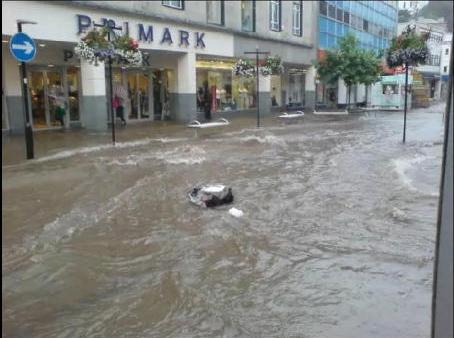
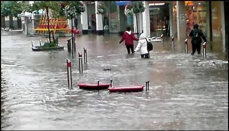
11 Historic Flooding Locations Flooding 20 th August 2007
12 DRAINAGE LEGISLATION AFFECTING LOCAL AUTHORITIES 1963 Water Resources Act 1973 Water Act 1989 Water Act 1995 Environment Act 2009 Flood Risk Regulations 2010 Flood and Water Management Act

13 DRAINAGE LEGISLATION AFFECTING LOCAL AUTHORITIES Flood & Water Management Act 2010
14 SECTIONS AFFECTING LEAD LOCAL FLOOD AUTHORITIES Designation of Lead Local Flood Authority Local flood risk management strategies Duty to investigate flooding Duty to maintain an asset register Designation of assets Issuing of consents and enforcement on ordinary watercourses
15 Sections of FWMA 2010 Awaiting Commencement Sustainable drainage systems provisions under Schedule 3 of FWMA Consultation closed on 13 th March 2012 over 300 responses. No date has been confirmed for the commencement of this section of the Act.


16 Flood Risk Regulations 2009 Torbay Council Preliminary Flood Risk Assessment
17 Flood Risk Regulations 2009 Torbay Council Preliminary Flood Risk Assessment
18 Flood Risk Regulations 2009 Torbay Council Preliminary Flood Risk Assessment


19 Flood Risk Regulations 2009 Torbay Council Preliminary Flood Risk Assessment
20 SCHEMES/ACTIONS TO REDUCE FLOOD RISK Construction of attenuation tanks Making Space for Water Pilot Study Torquay flood study Level 1 & 2 Strategic Flood Risk Assessments Surface water flood risk mapping Installation of depth monitors and raingauges Torquay town centre highway scheme Watercourse improvements

21 Construction of Attenuation Tanks in Torquay Newton Road Hele Tank Upton Tank Ellacombe Tank

22 Construction of Attenuation Tanks in Torquay Hele Tank, Torquay


23 Construction of Attenuation Tanks in Torquay Newton Road Tunnel
24 Torquay Flood Study: Data Collection Sewer Records Watercourse Surveys Mastermap Mapping Data Digital Terrain Data Aerial Photography Historic Flooding Records Rainfall Data Verified Hydraulic Model

25 Torquay Flood Study: Integrated Hydraulic Model Type 2 Model (WaPUG Guide) Originally Produced in 1993 Updated to include modifications Surface water sewers and watercourses added

26 Torquay Flood Study Infoworks 2D Results

27 Surface Water Flood Risk Mapping Torquay

28 Surface Water Flood Risk Mapping Torquay


29 Torquay Town Centre Highway Scheme
30 FUTURE MEASURES TO REDUCE FLOOD RISK Encourage use of sustainable drainage schemes in future development Torquay flood management plans Torquay town centre flood alleviation scheme Educate the public Defra flood resilience community pathfinder project
31 RAINGAIN TORBAY COUNCIL FLOOD RISK MANAGEMENT Any Questions?
Flood Risk Management New legislation New Duties!
 Flood Risk Management New legislation New Duties! Andy Cameron Lancashire County Council Senior Engineer Strategic Flood Risk Iwan Lawton Environment Agency Technical Specialist Development & Flood Risk
Shropshire Local Flood Risk Management Strategy. Summary for Consultation. July 2014
 Shropshire Local Flood Risk Management Strategy Summary for Consultation July 2014 SHROPSHIRE LOCAL FLOOD RISK MANAGEMENT STRATEGY 1 Introduction This Strategy is about managing flooding in Shropshire.
Flood Investigation Report
 Flood Investigation Report Bar Hill 1.1 Background As the Lead Local Flood Authority (LLFA) for Cambridgeshire, it is Cambridgeshire County Council s duty to investigate flood incidents as detailed within
Mapping flood risk its role in improving flood resilience in England
 Mapping flood risk its role in improving flood resilience in England Catherine Wright Director of Digital and Skills Flood and Coastal Risk Management Environment Agency 6 October 2017 The Environment
Devon Local Flood Risk Management Strategy Update
 Devon Local Flood Risk Management Strategy Update April 2015 Newsletter Devon s Local Flood Risk Management Strategy was published in June 2014, alongside Devon s Action Plan, prioritising investigation
Flood Investigation Report
 Flood Investigation Report Oakington 1.1 Background As the Lead Local Flood Authority (LLFA) for Cambridgeshire, it is Cambridgeshire County Council s (CCC) duty to investigate flood incidents as detailed
Canada s exposure to flood risk. Who is affected, where are they located, and what is at stake
 Canada s exposure to flood risk Who is affected, where are they located, and what is at stake Why a flood model for Canada? Catastrophic losses Insurance industry Federal government Average industry CAT
LINCOLNSHIRE COUNTY COUNCIL A DRAINAGE AUTHORITY and what it will mean for Lincolnshire MARK WELSH & DAVID HICKMAN THE LEGISLATION:
 LINCOLNSHIRE COUNTY COUNCIL A DRAINAGE AUTHORITY and what it will mean for MARK WELSH & DAVID HICKMAN ADA Local Authority Seminar Thursday 17 March 2010 Great Northern Hotel, Peterborough THE LEGISLATION:
Guildford Borough Level 1 Strategic Flood Risk Assessment Summary Report. January 2016
 Guildford Borough Level 1 Strategic Flood Risk Assessment Summary Report January 2016 What is this document? This document provides a summary of Guildford Borough Strategic Flood Risk Assessment (SFRA,
2018 PREPARING FOR A CHANGING CLIMATE AND MANAGING THE RISING FLOOD RISK
 Ireland Water 2018 PREPARING FOR A CHANGING CLIMATE AND MANAGING THE RISING FLOOD RISK Mark Adamson Office of Public Works 25 th April, 2018 FLOOD RISK IN IRELAND NATIONAL RISK ASSESSMENT, OEP 2012 & 2017
Report to Cabinet. 24 February Local Strategy for Flood Risk Management in the Black Country (Key Decision Ref. No. HE040)
") Agenda Item 8 Report to Cabinet 24 February 2016 Subject: Presenting Cabinet Member: Local Strategy for Flood Risk Management in the Black Country (Key Decision Ref. No. HE040) Highways and Environment
Agenda Item 8 Report to Cabinet 24 February 2016 Subject: Presenting Cabinet Member: Local Strategy for Flood Risk Management in the Black Country (Key Decision Ref. No. HE040) Highways and Environment
Role of the Flood & Water Management Committee & LCC as Lead Local Flood Authority
 Role of the Flood & Water Management Committee & LCC as Lead Local Flood Authority Page 1 Agenda Item 5 Page 2 21F of Local Government Act 2000 - Overview and scrutiny committees: flood risk management
CYNGOR SIR POWYS COUNTY COUNCIL. CABINET EXECUTIVE 18 th September Flood Risk Management Plan (FRMP)
") CYNGOR SIR POWYS COUNTY COUNCIL. CABINET EXECUTIVE 18 th September 2018 REPORT AUTHOR: SUBJECT: County Councillor Phyl Davies Portfolio Holder for Highways, Recycling and Assets Flood Risk Management Plan
CYNGOR SIR POWYS COUNTY COUNCIL. CABINET EXECUTIVE 18 th September 2018 REPORT AUTHOR: SUBJECT: County Councillor Phyl Davies Portfolio Holder for Highways, Recycling and Assets Flood Risk Management Plan
Newton Stewart (Potentially Vulnerable Area 14/12) Local Plan District Local authority Main catchment Dumfries and Galloway Solway River Cree Council
 Local Plan District Local authority Main catchment Dumfries and Galloway Solway River Cree Council") Newton Stewart (Potentially Vulnerable Area 14/12) Local Plan District Solway Local authority Dumfries and Galloway Council Main catchment River Cree Summary of flooding impacts 210 residential properties
Newton Stewart (Potentially Vulnerable Area 14/12) Local Plan District Solway Local authority Dumfries and Galloway Council Main catchment River Cree Summary of flooding impacts 210 residential properties
URBAN FLOOD RISK ASSESSMENT USING GIS BASED HYDRAULIC MODELLING
 Shirish Gokhale et al. : Urban Flood Risk Assessment Using GIS Based Hydraulic Modelling Journal of Advances in Engineering Science 77 Section D (1), January - June 2010, PP 77-84 URBAN FLOOD RISK ASSESSMENT
FLOOD SOLUTIONS Residence
 FLOOD SOLUTIONS Residence Report prepared on 22 Knighton Road, Liverpool, L4 9RD Report reference AEL028FLR022381 National grid reference 337815, 394462 Report prepared for Specimen Client Client reference
Turriff (Potentially Vulnerable Area 06/07) Local Plan District Local authority Main catchment North East Aberdeenshire Council River Deveron Backgrou
 Local Plan District Local authority Main catchment North East Aberdeenshire Council River Deveron Backgrou") Turriff (Potentially Vulnerable Area 06/07) Local Plan District North East Local authority Aberdeenshire Council Main catchment River Deveron Summary of flooding impacts At risk of flooding
Turriff (Potentially Vulnerable Area 06/07) Local Plan District North East Local authority Aberdeenshire Council Main catchment River Deveron Summary of flooding impacts At risk of flooding
Flood Risk Management Planning in Scotland: Arrangements for February 2012
 Flood Risk Management Planning in Scotland: Arrangements for 2012 2016 February 2012 Flood Risk Management (Scotland) Act 2009 1 Contents Forewords 1. Introduction to this document... 5 2. Sustainable
FLOOD RISK MANAGEMENT IN IRELAND
 National Flood Management Conference 2018 FLOOD RISK MANAGEMENT IN IRELAND Mark Adamson Office of Public Works 15 th March, 2018 FLOOD RISK IN IRELAND NATIONAL RISK ASSESSMENT, OEP 2012 Flooding: Joint
Local Flood Risk Management Strategy
 Local Flood Risk Management Strategy 2017 2019 Contents Section Pages Executive Summary 3 1.0 Introduction 4 2.0 Aims 5 3.0 Flood Risk in Poole 6 4.0 Drainage 10 5.0 Surface Water Management Plans 12 6.0
Alyth (Potentially Vulnerable Area 08/04) Local Plan District Local authority Main catchment Tay Perth and Kinross Council Alyth Burn (River Tay) Back
 Local Plan District Local authority Main catchment Tay Perth and Kinross Council Alyth Burn (River Tay) Back") Alyth (Potentially Vulnerable Area 08/04) Local Plan District Tay Local authority Perth and Kinross Council Main catchment Alyth Burn (River Tay) Summary of flooding impacts 50 residential properties 20
Alyth (Potentially Vulnerable Area 08/04) Local Plan District Tay Local authority Perth and Kinross Council Main catchment Alyth Burn (River Tay) Summary of flooding impacts 50 residential properties 20
eastsussex.gov.uk East Sussex Local Flood Risk Management Strategy
 eastsussex.gov.uk East Sussex Local Flood Risk Management Strategy 2013 2016 Foreword I am sure that you will agree that flooding has been at the forefront of all our minds over the past year. The country
London Borough of Sutton Local Flood Risk Management Strategy Action Draft for Consultation
 London Borough of Sutton Local Flood Risk Strategy Action Draft for Consultation This Action Plan supports the London Borough of Sutton Local Flood Risk Strategy (v1.0) July 2014. The reader should refer
Strategic Flood Risk Assessment for SDCC Development Plan
 Strategic Flood Risk Assessment for SDCC Development Plan Detailed Report on Flood Risk in the Baldonnell Area 8 th May 2015 rpsgroup.com/ireland Strategic Flood Risk Assessment for SDCC Development Plan
Dunblane and Bridge of Allan (Potentially Vulnerable Area 09/03) Local Plan District Local authority Main catchment Forth Stirling Council Allan Water
 Local Plan District Local authority Main catchment Forth Stirling Council Allan Water") Dunblane and Bridge of Allan (Potentially Vulnerable Area 09/03) Local Plan District Forth Local authority Stirling Council Main catchment Allan Water Summary of flooding impacts At risk of flooding 370
Dunblane and Bridge of Allan (Potentially Vulnerable Area 09/03) Local Plan District Forth Local authority Stirling Council Main catchment Allan Water Summary of flooding impacts At risk of flooding 370
Document Control Sheet
 Strategic Flood Risk Assessment of the Maynooth Local Area Plan 2013-2019 Proposed Amendment No. 1 Document Control Sheet Client: Project Title: Document Title: Document No: Kildare County Council Strategic
Local Flood Risk Management Strategy for Central Bedfordshire
 Central Bedfordshire Council www.centralbedfordshire.gov.uk Local Flood Risk Management Strategy for Central Bedfordshire Final February 2014 1 Foreword Following flooding in 2007, the government commissioned
Chelmsford City Council. Level 1 and Level 2 Strategic Flood Risk Assessment. Final Report
 Chelmsford City Council Level 1 and Level 2 Strategic Flood Risk Assessment Final Report October 2017 This page has been left intentionally blank 2015s3715 Chelmsford SFRA L1 and L2 Final Report v1.0.docx
Appeal by Lloyds Bank PLC
 Appeal by Lloyds Bank PLC Network Rail (Werrington Grade Separation) Order Transport and Works Act 19982 Town and Country Planning Act 1990 Land and buildings at Stirling Way, Peterborough Summary Proof
Strategic Flood Risk Assessment
 Strategic Flood Risk Assessment Draft Claremorris Local Area Plan 2012 2018 Prepared by Forward Planning Section Mayo County Council 1 Table of Contents Section 1: Overview of the Guidelines... 4 1.1 Introduction...
Managing the Risk and Impact of Regional Flooding
 Managing the Risk and Impact of Regional Flooding Ben Lukey FCRM Manager Strategy & Investment Environment Agency Wednesday 8 June 2016 Environment Agency - Who are we? Our role in Flood Risk Management
Kelso (Potentially Vulnerable Area 13/09) Local Plan District Local authority Main catchment Tweed Scottish Borders Council River Tweed Background Thi
 Local Plan District Local authority Main catchment Tweed Scottish Borders Council River Tweed Background Thi") Kelso (Potentially Vulnerable Area 13/09) Local Plan District Tweed Local authority Scottish Borders Council Main catchment River Tweed Summary of flooding impacts At risk of flooding 90 residential properties
Kelso (Potentially Vulnerable Area 13/09) Local Plan District Tweed Local authority Scottish Borders Council Main catchment River Tweed Summary of flooding impacts At risk of flooding 90 residential properties
Clyde south - Port Glasgow to Inchinnan (Potentially Vulnerable Area 11/09) Local Plan District Clyde and Loch Lomond Local authority Inverclyde Counc
 Local Plan District Clyde and Loch Lomond Local authority Inverclyde Counc") Clyde south - Port Glasgow to Inchinnan (Potentially Vulnerable Area 11/09) Local Plan District Clyde and Loch Lomond Local authority Inverclyde Council, Renfrewshire Council Main catchment Firth of Clyde
Clyde south - Port Glasgow to Inchinnan (Potentially Vulnerable Area 11/09) Local Plan District Clyde and Loch Lomond Local authority Inverclyde Council, Renfrewshire Council Main catchment Firth of Clyde
CLARBOROUGH AND WELHAM PARISH COUNCIL A FLOOD PREVENTION AND FLOOD MANAGEMENT STRATEGY. FLOOD PREVENTION STRATEGY DRAFT2 5 Sep 2017.
 CLARBOROUGH AND WELHAM PARISH COUNCIL A FLOOD PREVENTION AND FLOOD MANAGEMENT STRATEGY FLOOD PREVENTION STRATEGY DRAFT2 5 Sep 2017.docx 1 BACKGROUND Houses, businesses and land within the Parish of Clarborough
Objectives of this Briefing
 Eastern CFRAM Study (Catchment Flood Risk Assessment & Management) Stakeholders Briefing Poddle & Camac Watercourses Overview Grace Glasgow July 2013 Burns Beach near Brighton, Western Australia RPS has
Ness, Isle of Lewis (Potentially Vulnerable Area 02/01) Local Plan District Outer Hebrides Local authority Comhairle nan Eilean Siar Main catchment Le
 Local Plan District Outer Hebrides Local authority Comhairle nan Eilean Siar Main catchment Le") Ness, Isle of Lewis (Potentially Vulnerable Area 02/01) Local Plan District Local authority Comhairle nan Eilean Siar Main catchment Lewis and Harris coastal Summary of flooding impacts At risk of flooding
Ness, Isle of Lewis (Potentially Vulnerable Area 02/01) Local Plan District Local authority Comhairle nan Eilean Siar Main catchment Lewis and Harris coastal Summary of flooding impacts At risk of flooding
National Flood Risk Management Plan. CFRAM Programme
 National Flood Risk Management Plan AND THE CFRAM Programme Gerard O Connell, Engineer-in-Charge, Regional Projects & Flood Advisory Office Environmental SPC, 27 th June, 2018 HISTORIC & POLICY CONTEXT
Coupar Angus (Potentially Vulnerable Area 08/07) Local Plan District Local authority Main catchment Tay Perth and Kinross Council Coupar Burn (River T
 Local Plan District Local authority Main catchment Tay Perth and Kinross Council Coupar Burn (River T") Coupar Angus (Potentially Vulnerable Area 08/07) Local Plan District Tay Local authority Perth and Kinross Council Main catchment Coupar Burn (River Tay) Summary of flooding impacts Summary of flooding
Coupar Angus (Potentially Vulnerable Area 08/07) Local Plan District Tay Local authority Perth and Kinross Council Main catchment Coupar Burn (River Tay) Summary of flooding impacts Summary of flooding
Background to the PFRA European Overview - UC9810.5b
 Background to the PFRA European Overview - UC9810.5b The individual Member State Reports reflect the situation as reported by the Member States to the European Commission in 2012 The situation in the MSs
Nairn Central (Potentially Vulnerable Area 01/18) Local authority Main catchment The Highland Council Moray coastal Background This Potentially Vulner
 Local authority Main catchment The Highland Council Moray coastal Background This Potentially Vulner") Nairn Central (Potentially Vulnerable Area 01/18) Local authority The Highland Council Main catchment Moray coastal Summary of flooding impacts At risk of flooding 350 residential 30 non-residential 340,000
Nairn Central (Potentially Vulnerable Area 01/18) Local authority The Highland Council Main catchment Moray coastal Summary of flooding impacts At risk of flooding 350 residential 30 non-residential 340,000
Planning and Flood Risk
 Planning and Flood Risk Patricia Calleary BE MEngSc MSc CEng MIEI After the Beast from the East Patricia Calleary Flood Risk and Planning Flooding in Ireland» Floods are a natural and inevitable part of
Flood Risk Management in Ireland. The National CFRAM Programme & overview of the Capital Works Programme. Click to add text
 Flood Risk Management in Ireland The National CFRAM Programme & overview of the Capital Works Programme Click to add text Dr. John Martin Office of Public Works Engineers Ireland's Local Government Seminar
Ellon (Potentially Vulnerable Area 06/12) Local Plan District North East Local authority Aberdeenshire Council Main catchment River Ythan, Buchan coas
 Local Plan District North East Local authority Aberdeenshire Council Main catchment River Ythan, Buchan coas") Ellon (Potentially Vulnerable Area 06/12) Local Plan District North East Local authority Aberdeenshire Council Main catchment River Ythan, Buchan coastal Summary of flooding impacts 110 residential 40
Ellon (Potentially Vulnerable Area 06/12) Local Plan District North East Local authority Aberdeenshire Council Main catchment River Ythan, Buchan coastal Summary of flooding impacts 110 residential 40
Stirling (Raploch and Riverside) (Potentially Vulnerable Area 09/07) Local Plan District Local authority Main catchment Forth Stirling Council Stirlin
 (Potentially Vulnerable Area 09/07) Local Plan District Local authority Main catchment Forth Stirling Council Stirlin") Stirling (Raploch and Riverside) (Potentially Vulnerable Area 09/07) Local Plan District Forth Local authority Stirling Council Main catchment Stirling coastal Summary of flooding impacts At risk of flooding
Stirling (Raploch and Riverside) (Potentially Vulnerable Area 09/07) Local Plan District Forth Local authority Stirling Council Main catchment Stirling coastal Summary of flooding impacts At risk of flooding
LOW. Overall Flood risk. Flood considerations. Specimen Address, Specimen Town. Rivers and the Sea Low page 4. Historic Flood.
 Specimen Address, Specimen Town Overall Flood risk LOW Crown copyright and database rights 2018. Ordnance Survey licence 100035207 Groundsure Floodview complies with relevant Law Society practice notes
Strategic Flood Risk Assessment
 Strategic Flood Risk Assessment Ireland West Airport Knock Local Area Plan 2012 2018 Prepared by Forward Planning Section Mayo County Council 0 1 Table of Contents Section 1: Overview of the Guidelines...
Technical Memorandum 3.4 E Avenue NW Watershed Drainage Study. Appendix E Floodplain Impacts and Implications Memo
 Technical Memorandum 3.4 E Avenue NW Watershed Drainage Study Appendix E Floodplain Impacts and Implications Memo September 8, 2017 City of Cedar Rapids E Avenue Watershed Drainage Study Memo Date: Tuesday,
Volume Three. Pluvial Flood Risk Management
 EU Interreg IVB FloodResilienCity Project Final Report Dublin Volume Three Pluvial Flood Risk Management Document control sheet BPP 04 F8 Client: Project: Document Title: Dublin City Council Job No: 32102500
Consider the risks to your own business as well as to your operations
 Hayley Bowman Flood and Coastal Risk Management Mapping, Modelling and Data 07919 544 551 Hayley.bowman@environment-agency.gov.uk DataInfo@environment-agency.gov.uk EA covers England only. Wales covered
Good Practice Guide. GPG 101 Document Owner: Steve Cook. Page 1 of 7.
 Good Practice Guide Producing flood risk hydraulic models and flood consequence assessments for development planning purposes Date Published: September 2015 GPG 101 Document Owner: Steve Cook Page 1 of
Homecheck Flood. Click here. Overall Flood Risk. Insurability. Flood Defences. Individual Flood Risks.
 Homecheck Flood Overall Flood Risk PASSED The property is considered to be at minimal or no risk of flooding. However, you should ask the seller if the property has flooded in the past. The home buyer
The AIR Inland Flood Model for Great Britian
 The AIR Inland Flood Model for Great Britian The year 212 was the UK s second wettest since recordkeeping began only 6.6 mm shy of the record set in 2. In 27, the UK experienced its wettest summer, which
FLOODING INFORMATION SHEET YOUR QUESTIONS ANSWERED
 The information in this document has been written in partnership by the Association of British Insurers and the Environment Agency 1. Flood risk and insurance Q1. How can I find out the flood risk affecting
Wigan Local Flood Risk Management Strategy
 Wigan Local Flood Risk Management Strategy Revision Schedule Wigan Council Wigan Flood Risk Management Strategy Revisions Rev Date Details ails Prepared Reviewed Approved 1 24/04/14 2 05/06/14 3 11/06/14
LOCAL FLOOD RISK MANAGEMENT STRATEGY FOR HERTFORDSHIRE. STRATEGY (Vision) Part 1 of 4
 Part 1 of 4") LOCAL FLOOD RISK MANAGEMENT STRATEGY FOR HERTFORDSHIRE STRATEGY (Vision) Part 1 of 4 Geoperspectives 2011 Contents Executive Summary... 1 E1. Background... 1 E2. Relevance... 1 E3. Strategy Content...
LOCAL FLOOD RISK MANAGEMENT STRATEGY FOR HERTFORDSHIRE STRATEGY (Vision) Part 1 of 4 Geoperspectives 2011 Contents Executive Summary... 1 E1. Background... 1 E2. Relevance... 1 E3. Strategy Content...
Castle Douglas (Potentially Vulnerable Area 14/11) Local Plan District Local authority Main catchment Dumfries and Galloway Solway River Dee (Solway)
 Local Plan District Local authority Main catchment Dumfries and Galloway Solway River Dee (Solway)") Castle Douglas (Potentially Vulnerable Area 14/11) Local Plan District Solway Local authority Dumfries and Galloway Council Main catchment River Dee (Solway) Summary of flooding impacts 180 residential
Castle Douglas (Potentially Vulnerable Area 14/11) Local Plan District Solway Local authority Dumfries and Galloway Council Main catchment River Dee (Solway) Summary of flooding impacts 180 residential
Local Flood Risk Management Strategy Bedford Borough Council
 In fulfilment of the Flood & Water Management Act 2010 NOVEMBER 2015 Local Authority Officer Melanie Crump Senior Flood Risk Officer John Molyneux Head of Regulatory Services Department Regulatory Services,
Engineers Ireland Annual Conference
 Engineers Ireland Annual Conference MANAGING FLOOD RISK AND BUILDING SUSTAINABLE COMMUNITIES Mark Adamson Office of Public Works 15 th May, 2015 FLOOD RISK IN IRELAND RECENT FLOODS November 2009: >1,600
Fort William (Potentially Vulnerable Area 01/25) Local authority Main catchment The Highland Council Appin coastal Background This Potentially Vulnera
 Local authority Main catchment The Highland Council Appin coastal Background This Potentially Vulnera") Fort William (Potentially Vulnerable Area 01/25) Local authority The Highland Council Main catchment Appin coastal Summary of flooding impacts 100 residential properties 80 non-residential properties 520,000
Fort William (Potentially Vulnerable Area 01/25) Local authority The Highland Council Main catchment Appin coastal Summary of flooding impacts 100 residential properties 80 non-residential properties 520,000
Review of preliminary flood risk assessments (Flood Risk Regulations 2009): guidance for lead local flood authorities in England
: guidance for lead local flood authorities in England") Review of preliminary flood risk assessments (Flood Risk Regulations 2009): guidance for lead local flood authorities in England 25 January 2017 We are the Environment Agency. We protect and improve the
Review of preliminary flood risk assessments (Flood Risk Regulations 2009): guidance for lead local flood authorities in England 25 January 2017 We are the Environment Agency. We protect and improve the
East Sussex Local Flood Risk Management Strategy
 eastsussex.gov.uk East Sussex Local Flood Risk Management Strategy 2013 2014 Delivery Plan Delivery Plan The following table sets out the actions that will be progressed over the coming year by the risk
Strategic Environmental Assessment
 Strategic Environmental Assessment Cambridgeshire Local Strategy for Flood Risk Management 2012-2015 Non-Technical Summary - Hyder Consulting (UK) Limited 2212959 Manning House 22 Carlisle Place London
Conon Bridge and Muir of Ord (Potentially Vulnerable Area 01/16) Local authority Main catchment The Highland Council River Conon Background This Poten
 Local authority Main catchment The Highland Council River Conon Background This Poten") Conon Bridge and Muir of Ord (Potentially Vulnerable Area 01/16) Local authority The Highland Council Main catchment River Conon Summary of flooding impacts Summary of flooding impacts At risk of flooding
Conon Bridge and Muir of Ord (Potentially Vulnerable Area 01/16) Local authority The Highland Council Main catchment River Conon Summary of flooding impacts Summary of flooding impacts At risk of flooding
BLESSINGTON LOCAL AREA PLAN FLOOD RISK ASSESSMENT
 BLESSINGTON LOCAL AREA PLAN 2013-2019 FLOOD RISK ASSESSMENT Table of Contents Page Number 1.0 INTRODUCTION 1 1.1 Definition of Flooding 2 1.2 Policy Framework 2 1.3 Flood Risk Identification 3 1.4 Mapping
Understanding the risks, empowering communities, building resilience: the national flood and coastal erosion risk management strategy for England
 14669 NFS Cor Slip / Sig: 1 / Plate A Understanding the risks, empowering communities, building resilience: the national flood and coastal erosion risk management strategy for England Session: 2010-2012
Comhairle Baile Cheanntair~ Nás na Ríogh
 Comhairle Baile Cheanntair~ Nás na Ríogh DRAFT STRATEGIC FLOOD RISK ASSESSMENT NAAS TOWN DEVELOPMENT PLAN 2011 ~ 2017 Kildare County Council Water Services Department Aras Chill Dara Devoy Park Naas County
FloodSolutions Consult Residential
 FloodSolutions Consult Residential Sample, Road, Sample Town Report Prepared for: Sample client Client Reference: Not Supplied Report Reference: AEL-0000-FSCRsample National Grid Reference: 00000, 00000
Joint Lincolnshire Flood Risk and Drainage Management Strategy: Draft v.6.0:consultation Draft, : Annexes A-F
 Lincolnshire Flood Risk and Drainage Management Partnership Framework Lincolnshire Joint Flood Risk and Drainage Management Strategy Draft v.6.0 Consultation Draft 23 rd May 2012 Annexes A-F Joint Lincolnshire
CHAPTER 10 FLOOD RISK
 CHAPTER 10 FLOOD RISK 10.1 Introduction and Key Issues 10.1.1 This chapter describes the likely effects that the construction and operation of the Upgrade will have on flood risk. The potential effects
Flood Risk Assessment. Approved by RECOMMENDATIONS. Professional Opinion
 Flood Report Flood Risk Assessment Professional Opinion RECOMMENDATIONS 1. A prudent purchaser may wish to consider further assessment of the property to identify appropriate flood protection measures.
Dornoch (Potentially Vulnerable Area 01/07) Local Plan District Highland and Argyll Local authority The Highland Council Main catchment Dornoch coasta
 Local Plan District Highland and Argyll Local authority The Highland Council Main catchment Dornoch coasta") Dornoch (Potentially Vulnerable Area 01/07) Local authority The Highland Council Main catchment Dornoch coastal Summary of flooding impacts
Dornoch (Potentially Vulnerable Area 01/07) Local authority The Highland Council Main catchment Dornoch coastal Summary of flooding impacts
Bradford District. Local Flood Risk Management Strategy
 Bradford District Local Flood Risk Management Strategy 1 Executive Summary Adverse weather is a national concern and the risk of flooding in England is predicted to increase as a result of climate change
Arbroath (Potentially Vulnerable Area 07/07) Local Plan District Local authority Main catchment Tay Estuary and Montrose Basin Angus Council Brothock
 Local Plan District Local authority Main catchment Tay Estuary and Montrose Basin Angus Council Brothock") Arbroath (Potentially Vulnerable Area 07/07) Local Plan District Tay Estuary and Montrose Basin Local authority Angus Council Main catchment Brothock Water Summary of flooding impacts 250 residential properties
Arbroath (Potentially Vulnerable Area 07/07) Local Plan District Tay Estuary and Montrose Basin Local authority Angus Council Main catchment Brothock Water Summary of flooding impacts 250 residential properties
Local Flood Risk Management Strategy
 of London Local Flood Risk Management Strategy 2014-2020 September 2014 of London Local Flood Risk Management Strategy 2014-2020 Sept 2014 1 Contents 1 Introduction... 4 2 Flood Risk Management Strategy
Kirkwall (Potentially Vulnerable Area 03/05) Local Plan District Local authority Main catchment Orkney Orkney Islands Council Orkney coastal Backgroun
 Local Plan District Local authority Main catchment Orkney Orkney Islands Council Orkney coastal Backgroun") Kirkwall (Potentially Vulnerable Area 03/05) Local Plan District Orkney Local authority Orkney Islands Council Main catchment Orkney coastal Summary of flooding impacts 490 residential properties 460 non-residential
Kirkwall (Potentially Vulnerable Area 03/05) Local Plan District Orkney Local authority Orkney Islands Council Main catchment Orkney coastal Summary of flooding impacts 490 residential properties 460 non-residential
Ross of Mull (Potentially Vulnerable Area 01/30) Local authority Main catchment Argyll and Bute Council Island of Mull coastal Background This Potenti
 Local authority Main catchment Argyll and Bute Council Island of Mull coastal Background This Potenti") Ross of Mull (Potentially Vulnerable Area 01/30) Local authority Argyll and Bute Council Main catchment Island of Mull coastal Summary of flooding impacts At risk of flooding
Ross of Mull (Potentially Vulnerable Area 01/30) Local authority Argyll and Bute Council Main catchment Island of Mull coastal Summary of flooding impacts At risk of flooding
Managing flood risk in Camden The Camden flood risk management strategy Public consultation draft
 Managing flood risk in Camden The Camden flood risk management strategy Public consultation draft Contents 1. Foreword 3 2. Executive summary 4 3. Glossary 6 4. Introduction 8 4.1 Strategy objectives 8
DELIVERING SuDSAND THE PLANNING PROCESS IN LINCOLNSHIRE. Mark Welsh -Flood Water and Major Developments Manager Lincolnshire County Council
 DELIVERING SuDSAND THE PLANNING PROCESS IN LINCOLNSHIRE Mark Welsh -Flood Water and Major Developments Manager Lincolnshire County Council January 2014 THERE ARE 26 FLOOD RISK MANAGEMENT AUTHORITIES IN
Glasgow City centre (Potentially Vulnerable Area 11/16) Local Plan District Local authority Main catchment Clyde and Loch Lomond Glasgow City Council
 Local Plan District Local authority Main catchment Clyde and Loch Lomond Glasgow City Council") Glasgow City centre (Potentially Vulnerable Area 11/16) Local Plan District Clyde and Loch Lomond Local authority Glasgow City Council Main catchment River Clyde Summary of flooding impacts At risk of
Glasgow City centre (Potentially Vulnerable Area 11/16) Local Plan District Clyde and Loch Lomond Local authority Glasgow City Council Main catchment River Clyde Summary of flooding impacts At risk of
Nairn East and Auldearn (Potentially Vulnerable Area 05/08) Local Planning District Local authority Main catchment Findhorn, Nairn and Speyside The Hi
 Local Planning District Local authority Main catchment Findhorn, Nairn and Speyside The Hi") Nairn East and Auldearn (Potentially Vulnerable Area 05/08) Findhorn, Nairn and Speyside Local authority The Highland Council Main catchment River Nairn Summary of flooding impacts Summary of flooding
Nairn East and Auldearn (Potentially Vulnerable Area 05/08) Findhorn, Nairn and Speyside Local authority The Highland Council Main catchment River Nairn Summary of flooding impacts Summary of flooding
Strategic Flood Risk Assessment (SFRA)
") Strategic Flood Risk Assessment (SFRA) July 2007 (Final) London Borough of Hounslow The Civic Centre Lampton Road Hounslow TW3 4DN July 2007 (Final) EXECUTIVE SUMMARY Introduction 1. The London Borough
Strategic Flood Risk Assessment (SFRA) July 2007 (Final) London Borough of Hounslow The Civic Centre Lampton Road Hounslow TW3 4DN July 2007 (Final) EXECUTIVE SUMMARY Introduction 1. The London Borough
FLOOD SOLUTIONS Commercial
 FLOOD SOLUTIONS Commercial Overall Opinion PASSED Argyll's Overview The Site is not considered to be at a significant risk of flooding. This is as a result of flood defences in proximity to the Site which
The shifting sands of flood risk management in England and their impact on city governments.
 The shifting sands of flood risk management in England and their impact on city governments. John Blanksby Pennine Water Group, University of Sheffield j.blanksby@sheffield.ac.uk Three parts to the presentation
The Planning System and Flood Risk Management Guidelines for Planning Authorities
 Technical Appendices November 2009 Contents PAGE A. Identification and Assessment of Flood Risk 1 B. Addressing Flood Risk Management in Design of Development 35 A Appendix A: Identification and Assessment
STRATEGIC FLOOD RISK ASSESSMENT
 STRATEGIC FLOOD RISK ASSESSMENT FOR PROPOSED VARIATION NO. 1 (CORE STRATEGY) TO THE LONGFORD TOWN DEVELOPMENT PLAN 2009-2015 for: Longford Local Authorities Great Water Street, Longford, Co. Longford by:
Flood Risk Management Strategy. Shetland
 Flood Risk Management Strategy Shetland Publication date: 14 December 2015 Terms and conditions Ownership: All intellectual property rights for Flood Risk Management Strategies are owned by SEPA or its
Appendix 12.3 Flood Risk Assessment
 Appendix 12.3 Flood Risk Assessment Contents A12.3-1.1 Scope of Work 1 A12.3-1.2 Summary of Data Used 1 A12.3-1.3 Proposed Project 2 A12.3-2.1 The Planning System and Flood Risk Management Guidelines 2
River Lugg Internal Drainage Board. Policy Statement on Flood Protection and Water Level Management
 River Lugg Internal Drainage Board Policy Statement on Flood Protection and Water Level Management 1 INTRODUCTION Purpose 1.1 This policy statement has been prepared by the River Lugg Internal Drainage
Aberfeldy and Pitlochry (Potentially Vulnerable Area 08/03) Local Plan District Local authority Main catchment Tay Perth and Kinross Council River Tay
 Local Plan District Local authority Main catchment Tay Perth and Kinross Council River Tay") Aberfeldy and Pitlochry (Potentially Vulnerable Area 08/03) Local Plan District Tay Local authority Perth and Kinross Council Main catchment River Tay Summary of flooding impacts 240 residential properties
Aberfeldy and Pitlochry (Potentially Vulnerable Area 08/03) Local Plan District Tay Local authority Perth and Kinross Council Main catchment River Tay Summary of flooding impacts 240 residential properties
Forres (Potentially Vulnerable Area 05/06) Local Planning District Local authority Main catchment Findhorn, Nairn and Speyside The Moray Council Moray
 Local Planning District Local authority Main catchment Findhorn, Nairn and Speyside The Moray Council Moray") Forres (Potentially Vulnerable Area 05/06) Findhorn, Nairn and Speyside Local authority The Moray Council Main catchment Moray coastal Summary of flooding impacts Summary of flooding impacts At risk of
Forres (Potentially Vulnerable Area 05/06) Findhorn, Nairn and Speyside Local authority The Moray Council Main catchment Moray coastal Summary of flooding impacts Summary of flooding impacts At risk of
Local Government Group. Preliminary Framework to assist the development of the Local Strategy for Flood Risk Management.
 Preliminary Framework to assist the development of the Local Strategy for Flood Risk Management A Living Document February 2011 Preliminary Framework for Local Flood Risk Management Strategy Page 1 Table
River Findhorn (Potentially Vulnerable Area 05/07) Local Planning District Local authority Main catchment Findhorn, Nairn and The Highland Council, Ri
 Local Planning District Local authority Main catchment Findhorn, Nairn and The Highland Council, Ri") River Findhorn (Potentially Vulnerable Area 05/07) Findhorn, Nairn and Speyside Local authority The Moray Council, The Highland Council Main catchment River Findhorn Summary of flooding impacts 100 residential
River Findhorn (Potentially Vulnerable Area 05/07) Findhorn, Nairn and Speyside Local authority The Moray Council, The Highland Council Main catchment River Findhorn Summary of flooding impacts 100 residential
Inverurie and Kintore (Potentially Vulnerable Area 06/13) Local Plan District Local authority Main catchment North East Aberdeenshire Council River Do
 Local Plan District Local authority Main catchment North East Aberdeenshire Council River Do") Inverurie and Kintore (Potentially Vulnerable Area 06/13) Local Plan District North East Local authority Aberdeenshire Council Main catchment River Don Summary of flooding impacts 230 residential properties
Inverurie and Kintore (Potentially Vulnerable Area 06/13) Local Plan District North East Local authority Aberdeenshire Council Main catchment River Don Summary of flooding impacts 230 residential properties
Lower Lee (Cork City) Flood Relief Scheme (Including Blackpool and Ballyvolane)
 Flood Relief Scheme (Including Blackpool and Ballyvolane)") STUDY AREA MAP N LEGEND: Study Area (for which flood alleviation measures are to be identified) Additional Environmental Study Area (assessment area of environmental affects from proposed flood alleviation
STUDY AREA MAP N LEGEND: Study Area (for which flood alleviation measures are to be identified) Additional Environmental Study Area (assessment area of environmental affects from proposed flood alleviation
Low. Yes. Low. Surface water. Other*
 Overall Opinion Passed The site is not considered to be at significant risk of flooding. No further action is considered necessary. However, it would be prudent to consider the measures outlined in the
Oban (Potentially Vulnerable Area 01/31) Local authority Main catchment Argyll and Bute Council Knapdale coastal Background This Potentially Vulnerabl
 Local authority Main catchment Argyll and Bute Council Knapdale coastal Background This Potentially Vulnerabl") Oban (Potentially Vulnerable Area 01/31) Local authority Argyll and Bute Council Main catchment Knapdale coastal Summary of flooding impacts 320 residential properties 310 non-residential properties 1.8
Oban (Potentially Vulnerable Area 01/31) Local authority Argyll and Bute Council Main catchment Knapdale coastal Summary of flooding impacts 320 residential properties 310 non-residential properties 1.8
FloodSolutions Commercial
 FloodSolutions Commercial Overall Opinion PASSED Argyll's Overview The Site is not considered to be at a significant risk of flooding and buildings and contents insurance should be available and affordable.
BeST Case Study. Managing flood risk in Killingworth and Longbenton. BeST Case Study Killingworth and Longbenton
 BeST Case Study Managing flood risk in Killingworth and Longbenton Background In 2010 Northumbrian Water commenced a series of Sustainable Sewerage Studies to understand flood risk across a number of catchments.
Chapter Flood Consequences
 Chapter 2.16. Flood Consequences 438 16. Flood Consequences 16.1. Introduction and Scope of Topic 16.1.1. This chapter identifies and describes the existing flood risk features along the route of the Scheme
Bolton s Flood Risk Management Strategy
 Bolton s Flood Risk Management Strategy www.bolton.gov.uk Ringley Old Bridge over the River Irwell; built 1677. It replaced a previous bridge lost in a flood in 1673. Revision History Revision Ref Amendments