Local Flood Risk Management Strategy
|
|
|
- Amos Rice
- 5 years ago
- Views:
Transcription

1 Local Flood Risk Management Strategy
2 Contents Section Pages Executive Summary Introduction Aims Flood Risk in Poole Drainage Surface Water Management Plans Flood Risk Management Objectives Appendices: Appendix A Environment Agency s Flood Risk Maps Surface Water and Tides Appendix B Surface Water Flood Risk Catchment Areas in Poole Appendix C Surface Water Management Plans Priority Production Timetable Appendix D Responsibilities of Risk Management Authorities Publication details Purpose: A statutory requirement to outline how the flood risk from surface water is being managed in Poole. Produced by: Stuart Terry, Flood & Coastal Erosion Risk Manager, Borough of Poole Published: July 2017 Review Date: 2019 DRAFT Published: January 2016 Consultation: 28 Jan Mar 2016 Contact: fcerm@poole.gov.uk Distribution: 2


3 Executive Summary Following the national floods of 2007, which affected over 55,000 homes and businesses across the UK, the Government made it a legal requirement to produce a Local Flood Risk Management Strategy. This ensures every Lead Local Flood Authority takes strategic responsibility for managing the risk of flooding. Poole, unlike many other areas in the UK, has not experienced severe flooding so our primary tool for identifying future flood risk is being generated by computer modelling. To date we have used flood risk mapping provided by the Environment Agency but, over time, the modelling will be updated with real information following exceptional weather events that affect our town. This will serve to make our modelling, and thereby flood predictions, increasingly accurate. The Flood and Water Management Act (2010) acknowledged that despite everyone s best efforts to prevent the risk of flooding, it is a natural event that will sometimes occur. The Borough of Poole will use Surface Water Management Plans to address all types of flooding from tides, surface water and drainage. Solutions will be investigated for these specific areas and discussed with neighbouring authorities to help identify funding opportunities and a timescale for implementation of potential solutions. However, there will be areas where there is no environmental or economic solution to protect property and/or infrastructure. In such circumstances the Local Resilience Forum will be informed so that they can plan to respond to flooding risk or incidents in the most efficient way. Where feasible we will include environmental enhancements into flood management schemes, such as Bourne Valley Park, to help provide beneficial habitats for wildlife and new environments for people to enjoy. Councillor John Rampton Portfolio Holder Environment & Consumer Protection 3


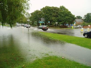
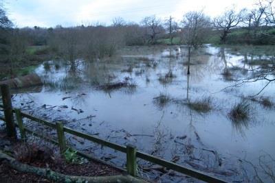
4 1.0 Introduction In 2010, the Government introduced the Flood and Water Management Act. This followed the national floods caused by surface water after extreme rain storms in 2007, which affected over 55,000 homes and businesses across the UK. It acknowledged flooding as a natural event that will sometimes occur despite everyone s efforts to prevent it. The Act requires every county or unitary authority to be a Lead Local Flood Authority and to develop a Local Flood Risk Management Strategy, to take strategic responsibility for managing local flood risk. The Act considers flooding to be from: 1. Surface water: Rain water run-off from roads and roofs. Rain water collecting at the bottom of Pinecliff Road and The Avenue, near Branksome Chine. 2. Groundwater: Water which percolates through the ground. 3. Ordinary water courses: Streams and ditches. The stream in Branksome Chine gardens bursting its banks. However, the Government recognises that no single organisation can effectively manage flood risk alone and, in Poole, identifies the following organisations as the Risk Management Authorities (RMAs): The Lead Local Flood Authority (Borough of Poole) The Environment Agency Wessex Water 4

5 2.0 Aims Flood risk management must support both national and local plans for sustainable development. It requires both existing and proposed infrastructure, housing and commercial or industrial development to be fit for today s needs and ensure future generations have the same, if not improved, quality of life. Poole Council is, therefore, required by law to take specific actions to manage this risk. The Act requires all Risk Management Authorities (RMAs), outlined in Section 1.0, and other stakeholders to work together to consider and deliver measures to reduce flood risk and manage the impact and disruption if surface water flooding does happen. Stakeholders also identified as having a responsibility to manage flood risk in Poole, include: Residents situated in flood risk zones Businesses situated in flood risk zones Network Rail Other Lead Local Flood Authorities including Bournemouth Borough Council and Dorset County Council Local Resilience Forum (civil emergency planning) By working together with RMAs and stakeholders, Poole s Local Flood Risk Management Strategy will aim to: 1. Identify flood risk areas across the Borough. 2. Produce an action plan for the implementation of measures to reduce flood risk and associated long term flood damage costs, where feasible. 3. Improve stakeholders knowledge about flood risk and their responsibilities in managing it. 4. Implement protocols and procedures for issuing advice to enable individuals to plan responses to an extreme event (emergency planning). This Strategy will be reviewed in conjunction with the Council s Core Strategy (right) and Strategic Flood Risk Assessment; once every five years. However, if a major flood event occurs during the meanwhile, the subsequent investigation may recommend an earlier review. Surface Water Management Plans will assess the risk and impact of a 1 in 100 year storm event. Where the drainage of the land could be influenced by high tides, this will be raised to include a 1 in 200 year event. See diagram overleaf to explain how surface water drainage is managed in Poole. 5

. Sea walls are designed for a 1 in 200 year extreme tidal event and are owned and maintained by the Environment Agency. ordinary water courses such as streams and ditches.")
6 3.0 Flood Risk in Poole A 1 in 100 year flood event* does not mean a flood will happen just once every 100 years. It is a way of describing the severity of the event and sometimes these can occur more than once in the same year. *A one in one hundred chance or a 1% chance of an event happening in any given year. Fig. 1 Drainage Systems for Surface Water in Poole There are currently a number of design standards for drainage systems to help reduce the risk of flooding in Poole from: the sea (including Poole Harbour). Sea walls are designed for a 1 in 200 year extreme tidal event and are owned and maintained by the Environment Agency. ordinary water courses such as streams and ditches. These are owned and managed by the landowner and should be designed for a 1 in 100 year rain storm event. surface water drains. These are owned and managed by Wessex Water and are designed for a 1 in 30 year rain storm event. road drains and gullies. These are owned and managed by the Highway Authority (Borough of Poole) and are designed for a 1 in 5 year rain storm event. 3.1 Surface Water: Rain water run-off from roads and roofs Flood modelling to assess high level risk was undertaken by the Environment Agency on a national scale. Currently all publically available flood maps only indicate one type of flooding i.e. tidal flooding or surface water flooding see Appendix A. In Poole it indicated there are a number of properties across the town which could be at risk of flooding during a severe rain event. The modelling also highlighted that, despite development, natural drainage valleys remain. In an extreme rain event, flood water could naturally take these routes which could increase flooding risk. 6


 climate change data for modelling purposes which is reviewed periodically.")
7 This was demonstrated in August 2011 when Poole experienced a near-miss with a localised storm. Around 100 properties were affected, 35 of which suffered internal flooding. Neighbouring Bournemouth was also affected with a reported 200 properties suffering from internal flooding. However, the torrential rains causing the summer floods of 2012 across the UK had little effect on the town. In Poole we have little recent historic evidence of severe flooding, so to assess the impact of a 1 in 100 year storm, Surface Water Management Plans will be developed using computer modelling. This will identify where management of the surface water may be required. The anticipated increase in stormy weather as a result of climate change will also be assessed. The Council will use Defra 1 (Defra) climate change data for modelling purposes which is reviewed periodically. During a wet period in 2013, the Council installed 100 monitors for three months in surface water drains around Poole to record water flow. This helped to build and validate the computer modelling. In February 2016 eight long-term flow monitors were installed in low-lying areas next to Poole Harbour. The sensors installed in surface water drains measure the speed and depth of the water flow in the pipes. This information is recorded and used to inform computer modelling. In addition, three permanent rain gauges (right) have been installed in Poole. These are located at Hamworthy Fire Station, Parkstone Golf Course and Branksome Heath Junior School. Information from these gauges can be viewed at: During flood events and subsequent investigations rainfall data and survey information will be run through the model. Over time, as we glean more information, to validate the computer modelling, the model outputs will become increasingly accurate. 1 Department for the Environment, Fisheries & Rural Affairs 7

8 This learning by doing technique will enable us to see if the predicted outcome of the model is an accurate reflection of the flooding that actually occurred. The proposed Surface Water Management Plans will assess a range of rain storms: 1 in 30, 50, 75 and 100 year events. A 1 in 100 year event is the maximum event used to predict surface water flood risk and consider flood management solutions whilst being able to attract inward investment from the Government s grant aid process. 3.2 Groundwater: Water which percolates through the ground Poole s flow monitors also recorded water flow during dry periods, which can be indicative of infiltrations from ground water. From this data it was possible to assess there is generally little risk from Ground Water Flooding in the town. This information tallies with historical data which shows little flooding from ground water, with the exception of a small number of tidal cellars located in Poole Old Town. 3.3 Ordinary water courses: Streams and ditches As Poole grew during the 19 th and 20 th century, many of the streams and ditches were piped-in underground to enable development to take place. However, there are still a number of open streams and ditches which are integral to the town s drainage system. Streams and ditches collect surface water run-off and some surface water drains run into and out of them again. At times, like rivers, the open streams and ditches will burst their banks and overflow into the historic flood plains (which often have been built over). Streams and ditches will also be incorporated in the Council s computer modelling. Coy Pond Gardens, Surrey Road Bourne Stream bursting its banks. 3.4 Tidal & In-combination Flooding: Poole has areas which are low-lying and adjacent to the Harbour. The height of the water in the Harbour may cause tidal locking of both streams and surface water drains and it is believed this could have an effect on the extent and depth of flooding. Tidal locking is where the high tide stops the surface water coming out the end of the surface water drain. 8


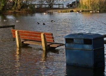
9 Although the assessment of tidal flooding from Poole Harbour is not a requirement of the Flood and Water Management Act it will be included in Poole s Local Flood Risk Management Strategy to ensure a full flood risk assessment is undertaken. If a rain storm occurs at the same time as high tide, the resulting in-combination flooding could occur from surface water drains. The proposed Surface Water Management Plans will assess this risk. In-combination flooding will also include analysis of computer models verified against actual rainfall, flow monitoring and tidal data which can then be used to predict the impact of major rain storms. Where there is an in-combination risk of flooding from simultaneous high tides and rainfall we will assess events up to a 1 in 200 year tidal event. This is the maximum event used to predict tidal flood risk and consider flood management solutions whilst being able to attract inward investment from the Government s grant aid process. More information about tidal flooding and its impact on Poole can be found at: Poole and Christchurch Bays, Shoreline Management Plan: Poole Strategic Flood Risk Assessment: The Poole and Wareham Flood and Coastal Erosion Risk Strategy: Results of high tide and heavy rain on Sandbanks Road, near Whitecliff Park. Tidal flooding in Poole, Shore Road. 9
; one for surface water and one for foul water.")
10 4.0 Drainage Drainage is the artificial removal of surface and sub-surface water from an area. Poole s water drainage is serviced by two types of drains (or sewers); one for surface water and one for foul water. Rainwater from hard surfaces such as roads, pavements, roofs and drainpipes is collected in surface water drains. During storms run-off will be significant. Dirty water such as that from toilets, sinks, baths, showers, dishwashers and washing machines is collected in foul water drainage. Generally, surface water drainage pipes are designed to accommodate between a 1 in 20 and a 1 in 30 year storm event (refer to Fig. 1 in Section 3.0). In an exceptional event the drains would not cope and the exceedance flow would run over the ground. The routes and effects of the exceedance flow will be modelled in the Surface Water Management Plans. 4.1 Natural Drainage As mentioned in section 3.3 much of the town s natural drainage was lost during the urbanisation of Poole. Hard surfaces such as roofs, roads and pavements stop rain water from soaking into the ground so fast moving water, during periods of heavy rainfall, is experienced. As the surface water moves it can collect dirt, debris and oil along the way which, as well as causing flooding, can cause pollution in rivers and streams. As more hard surfaces are created, the problem gets worse and the underground drainage system has to handle more water than it was designed to. Sustainable Drainage Systems (SuDs) help reduce the risk of surface water flooding in urban areas. They are garden, landscape, structural and drainage features capable of holding, absorbing, slowing and filtering (cleaning) rainwater. They replicate what happens in the natural environment before rainwater re-enters streams and rivers. As well as helping to provide a solution to overloaded drainage systems, they also provide beneficial habitats for wildlife and create environments for relaxing, learning and play. Sue Seiger Unused playing fields in Bourne Valley Park, Alderney, were transformed with extensive earthworks and landscaping to provide a range of habitats, including reed-beds, heathland and a wild flower meadow. 10


11 Working with nature to re-instate more natural drainage regimes, where possible, is an aspiration for Poole s proposed Surface Water Management Plans. When a proposal is made to use natural spaces for flood attenuation water, all appropriate assessments will be made, including amenity assessment. To reduce the risk of future surface water flooding the Local Planning Authority now requires all new major developments to implement SuDS, where reasonably practicable. In an urban area like Poole the vast majority of these will be soakaways and permeable paving, to enable the water to drain back into the ground, as it would naturally. Where the Bourne Stream flowed beneath the park in a pipe, a 450m long open and terraced stream channel has been reinstated. During heavy rainfall, the stream acts as a holding basin, designed to provide 3,500cu.m. of storm water storage. This sustainable drainage system uses natural processes, to reduce flash flooding and improve local water quality. Examples of other SuDS features include: reed beds, swales, filter strips, ponds, rainwater butts, and living green roofs. Typical illustration of a soakaway receiving water from roofs and driveways (right) and example of permeable paving (below). aco.co.uk pavingexpert.com 11


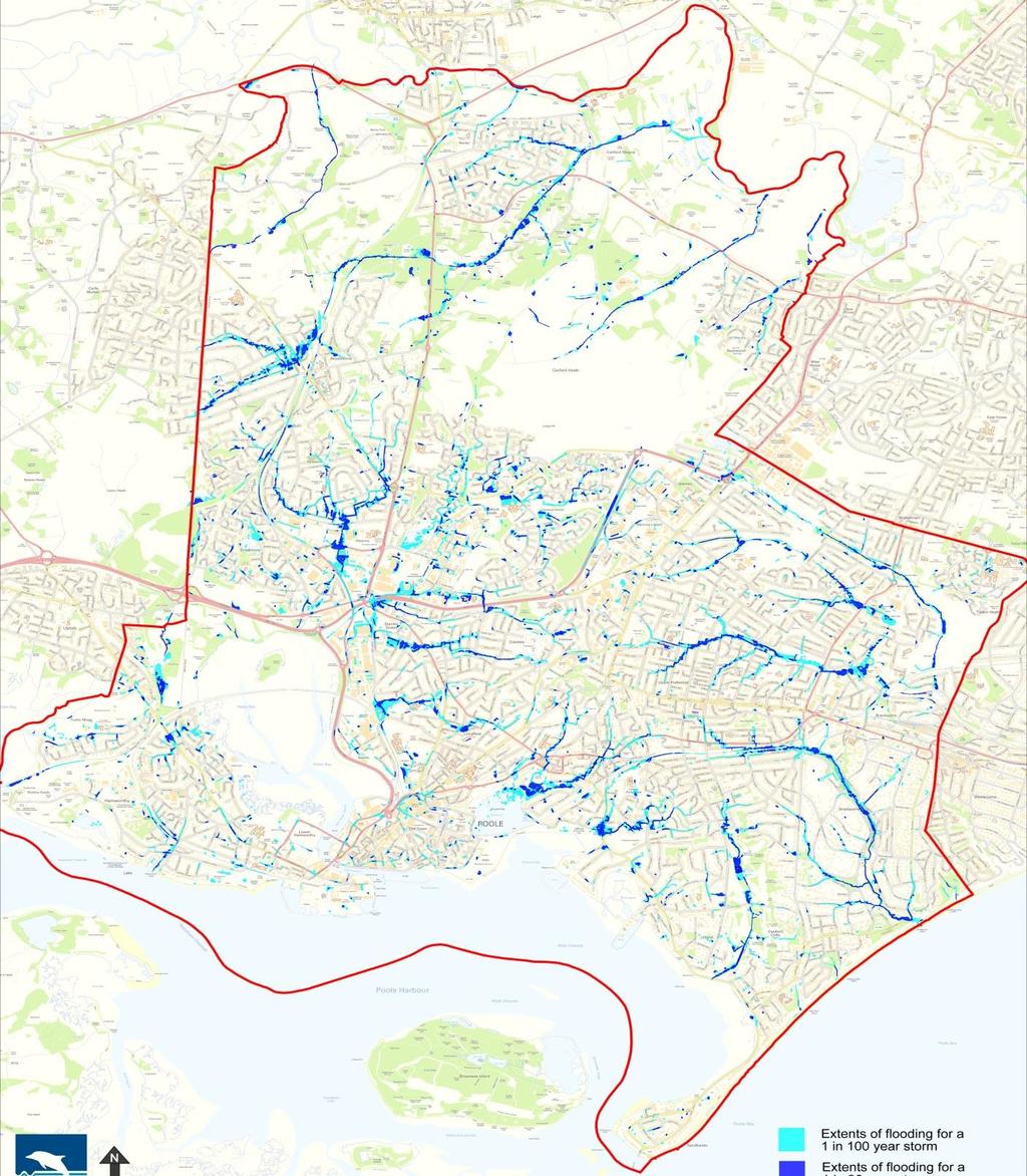
12 5.0 Surface Water Management Plans The Borough of Poole will use Surface Water Management Plans (SWMPs) to understand the risk of all types of flooding from, surface water, natural drainage and tides. They will be developed using information supplied by the Environment Agency and will assess a range of rain storms: 1 in 30, 50, 75 and 100 year events. The model outputs will enable the Council to assess flood risks, who needs to manage that risk and what solutions (subject to funding) could be delivered. During flood events and subsequent investigations the Council will input rainfall data and survey information through the model. This learning by doing technique will enable the Council to see if the predicted outcome is an accurate reflection of the flooding that actually occurred. Over time, as we glean more information, the model outputs will become increasingly accurate and validate the computer modelling. Poole s flood risk areas have been identified on the map located at Appendix B. The boundaries follow natural water catchment areas. Some of these are very small with local discharge points into Poole Harbour so, for ease, these have been amalgamated into the Poole Town and Parkstone catchments. This also enables the incombination effect of high tide and rain to be analysed. The SWMPs will be undertaken on a risk based priority. The first of these will be in areas near to Poole Harbour because the risk of in-combination, tide and surface water is not fully understood at this time. The remainder will follow on as indicated in the priority production timetable in Appendix C. Each SWMP will have its own action plan covering potential flood risk management schemes that could be implemented; if they meet the current Environment Agency guidance for financial support relating to Flood Defence Grant in Aid, including partnership funding. Surface Water Management Plans will be prioritised and initially carried out for the areas in Poole with the highest risk of flooding. 12
13 Due to the urban nature of Poole and the level of funding currently received from Defra 2, it is unlikely that solutions will be delivered for each of the flood risk areas. However, where funding is available, we will look to deliver schemes to protect residential homes, shops and factories from internal flooding. This is why it is essential all Risk Management Authorities and stakeholders are aware of their individual responsibilities and must work to reduce the likelihood and impact of flooding (even though this may still happen). Responsibilities of Risk Management Authorities are found in Appendix D. Lead Local Flood Authorities are also required to share information on the periphery of Poole, where the water does not respect administration boundaries. Examples are: Hamworthy catchment includes parts of Upton (Dorset County Council) as the water discharges into Poole. Bearwood, whilst in Poole, receives some water from Bournemouth. In this instance the initial computer modelling has been done by Bournemouth Council and Wessex Water. 6.0 Flood Risk Management The Local Flood Risk Management Strategy needs to consider the flood risks we face in Poole, the measures that could be taken to manage flooding, how such measures might have multiple benefits (to the local economy, communities and the environment) and how such measures could be funded. 6.1 Recording and Maintaining Assets The Flood Water Management Act requires Borough of Poole to hold an asset database for all flood and coast risk infrastructure which could have a significant effect on flooding. For Poole this will include: Sea walls on the beach frontage and Poole Harbour. Culverted (piped) watercourses. Ordinary watercourses such as streams and ditches. Surface features (eg walls or embankments) acting as a flood defence assets, which could adversely affect exceedance flows. All asset owners are responsible for inspecting and maintaining their own assets. Council assets are maintained by a variety of sections who are each responsible for maintaining and checking their condition. The Council does not maintain pipework on private land; they are the responsibility of the land owner unless they are public 2 Department for the Environment, Fisheries & Rural Affairs 13

 which is likely to cause surface water flooding.")
14 surface water drains. The public surface water drainage system within Poole is owned and operated by Wessex Water. The Council has access to these records and the data will used in the computer modelling. Well maintained assets cannot prevent flooding happening but can lessen its impact and probability. For example, generally Wessex Water drains are designed to cope with a 1 in 20 to a 1 in 30 year storm. When rainfall exceeds this level of event, water will flow over-land (on hard surfaces such as roads and pavements) which is likely to cause surface water flooding. Highway drainage is normally designed to cope with a 1 in 5 year storm. Rain storms of greater intensity could cause surface water flooding on roads and in other areas. Surface water forcing its way out of an underground drain through a manhole cover in Branksome Chine beach car park (above) and running off a road into the green space of Coy Pond (below). Ordinary Water Courses belong to the owner of the land they travel through or pass over. These are often in private ownership and therefore the landowner is responsible for maintenance and clearance. For further advice, or for those wishing to carry out work on their watercourse, fcerm@poole.gov.uk 6.2 Responding to flood events The Council s Environment & Consumer Protection section undertake the maintenance of all Council owned drainage assets and assist, where possible, when floods occur. Prior to flood events they aim to: programme maintenance activities such as gully emptying in areas at greater risk of flooding. work with Wessex Water who are responsible for the public drains, beyond highway drainage. prioritise planning and response to Environment Agency alerts and warnings and liaise with the emergency services. encourage residents and businesses to plan and prepare for flooding. 14

15 if feasible and time permits, be on site, notifying properties and businesses likely to be impacted by tidal flooding in and around Poole Quay, West Quay and Lower Hamworthy. be on site during the risk period of any Environment Agency warnings or severe weather warnings. During a flood event they will work with the Local Resilience Forum to co-ordinate a response and provide advice to those affected. Whilst the Council can assist in some aspects of preparing or responding to a flood event, there are unable to: inspect, clean and prepare every drain, ditch and culvert. respond to every flooding incident (inspection and response will be prioritised). provide sandbags and other flood defence equipment to residents or businesses. An intense and very isolated summer storm in August 2011 caused localised flooding in Hatch Pond Road, as well as some other areas of Poole. The storm lasted about an hour but a subsequent investigation was carried out. The extent and depth of flood events will be recorded and analysed so the information can be used and compared to the computer model. 6.3 Funding and delivering flood mitigation schemes There will always be a limited amount of funding available from national/ local government and it is not economically, socially or environmentally feasible to resolve all flooding issues. The Council will use information gleaned from Surface Water Management Plans to identify whether the flood risk in Poole meets the required criteria to potentially obtain the Government s Flood Defence Grant in Aid Funding or the Environment Agency Local Levy Fund. If it does, applications will be made but, to date, Poole has made no submissions. New legislation also requires partnership funding from other sources so this Strategy will include an action plan to develop new ways of working with other organisations and communities to raise further funds and prioritise areas for further flood risk investigation and/or investment. 15
16 6.4 Considering flood risk during planning approval for major new developments Borough of Poole, as Lead Local Flood Authority, is now a statutory consultee during planning approval for major new developments and will now consider surface water flood risk. This includes the aspiration for more natural forms of drainage, as set out in section 4.1. Non-structural solutions could include spatial planning in the form of sustainable planning for new development, development control and environmental enhancement. This could influence where and how new major developments are constructed. This will enable the Council to advise developers, through the planning process, to help build resilience into existing properties where they are being refurbished or extended. 6.5 Civil Emergency Planning The Local Resilience Forum will be provided with updated predicted flood risk areas from the computer (flood risk) modelling. This will enable emergency plans to be developed for a variety of flood events and support communities to become more resilient to flooding events. 16
17 7.0 Objectives Objective reference Objective Measures Progress Target Completion 1 Computer modelling to better understand all flood risk in Poole. 1.1 Initial rain data/flow monitor collection. 1.2 Install temporary rain gauges and flow monitors. Started 2014 Completed Improve model predictions. 2.1 Install permanent rain gauges. 2.2 Install long term flow monitors. 2.3 Post event flood investigations and surveys to glean information from rain events and the public. 3 Produce Surface Water Management Plans (SWMPs) to identify flood risk areas in detail. 4 Improve information provision regarding flood risk. Started 2015 On-going 3.1 Identify actual areas at risk from flooding. Started 2015 Dec Produce individual action plans to highlight possible risk management solutions. 3.3 Inform Risk Management Authorities, Local Resilience Forum and the public of the outcomes of SWMPs. 3.4 Produce flood risk maps for the Local Planning Authority 4.1 Develop information on web pages. Started 2015 Dec 2017 and on-going 5 Improve level of understanding of local flood risk within the Lead Local Flood Authority. 5.1 Record coastal, drainage and flood assets. 5.2 Maintain a Public Asset Register. 5.3 Record and map flood incidents. Started 2014 On-going 17
18 6 Maximise the benefits from partnership working with flood risk partners and stakeholders. 7 Actively manage flood risk associated with new development. 6.1 Develop more effective partnership working with Wessex Water and the Environment Agency. 6.2 Produce an action plan for jointly delivering potential schemes to reduce flood risk in Poole where economically and environmentally feasible. 6.3 Develop a pragmatic programme of schemes and initiatives which are likely to be funded through Grant in Aid or Local Levy. 6.4 Develop schemes that have environment benefits away from flood risk management i.e. park regeneration that may be acceptable for flood storage. 7.1 Develop and apply a robust local Flood Risk Management policy on drainage solutions for new major developments. 7.2 Develop a process with the Local Planning Authority to create clear advice and direction to developers on Flood Risk Management and drainage. 7.3 Improve skills and knowledge of Planning Officers involved with flood risk management. 7.4 Identify areas within the built environment where resilience should be included in future developments or re-developments. Started 2015 On-going Started 2015 On-going 18

19 8.0 Appendices Appendix A ENVIRONMENT AGENCY S SURFACE WATER FLOOD RISK MAP 19

20 Appendix A continued ENVIRONMENT AGENCY S RIVERS & SEA FLOOD RISK MAP 20

21 Appendix B SURFACE WATER FLOOD RISK CATCHMENT AREAS IN POOLE The Surface Water Management Plan boundaries follow, where possible, natural water catchment areas and not the Borough of Poole Council Ward or administration boundaries. 21
22 Appendix C SURFACE WATER MANAGEMENT PLANS PRODUCTION BY PRIORITY* Catchment Area Priority Surface or Joint 1 Comment. Creekmoor 1 J Known in-combination flooding could be significant. Hamworthy 2 J Tidal influence could be significant includes flows from Upton. Town Centre & Parkstone. 3 J Tidal influence could be significant. Canford Heath 4 S Broadstone 5 S Bearwood & Merley 6 S Cross border flow modelling by Wessex Water and Bournemouth Council. Bourne Valley 7 S Coastal 8 S 1 Risk of flooding from Surface: surface water only and Joint: in-combination; tide and surface water. The numbers of properties at risk will be based on Borough of Poole modelling; considered in conjunction with figures provided by the Environment Agency. The Surface Water Management Plans will advise of the numbers of properties potentially at risk from flooding. *As of July 2017, subject to change 22
23 Appendix D RESPONSIBILITIES OF RISK MANAGEMENT AUTHORITIES Within Poole the Risk Management Authorities (RMAs) and their associated main roles, responsibilities and functions are to be exercised as follows: The Borough of Poole as Lead Local Flood Authority Duty to produce a strategy for local flood risk management. Strategic leadership of local risk management authorities. Reduce the risk of flooding from surface water, groundwater and ordinary watercourses. Power to request information from a person or organisation relating to its flood management responsibilities. Duty to investigate significant flood incidents and determine and allocate responsibilities. Duty to maintain a register of structures or features likely to have significant effect on flood risk. Power to designate structures and features relating to flood risk, other than from a main river. As a statutory consultee on major planning applications advise on land use planning process to mitigate flood risk resulting from new or redevelopment of land. Duty to ensure the local flood risk management functions is consistent with the national strategy. Power to consent works on Ordinary Watercourses. The Environment Agency Strategic overview of all forms of flooding. Risk based management of flooding from main rivers. Regulation of the safety of high risk reservoirs. Development of the National Strategy for Flood and Coastal Erosion Risk Management. Coordination of the Regional Flood and Coastal Committees. Powers to designate structures and features relating to main rivers. A duty to report to Ministers on flood risk management. Statutory consultee on development within knows flood risk areas. Power to undertake flood risk management schemes on main rivers and the coastal environment. 23
24 Water Companies Wessex Water Assist the Lead Local Flood Authority (LLFA) in meeting their duties in line with the national strategy and guidance. Assist the LLFA in meeting their duties in line with the Local Flood Risk Strategy. Share information and data with RMAs relevant to their flood risk management duties. A duty to effectively drain their area in accordance with Section 94 of the Water Industries Act Duty to register all reservoirs with a capacity of greater than 10,000m3 with the Environment Agency- this relates to both Wessex Water and Bournemouth and West Hants Water Company. Maintain a register of properties at risk from hydraulic overloading in the public sewerage system (DG5 register). The appropriate management of surface water in sewers. Encourage the use of Sustainable Drainage Systems. Create a detailed understanding of the flood risk from the public sewer system. Explore and implement multi benefit / agency schemes. The Borough of Poole as the Highway Authority Duty to act in a manner which is consistent with the local and national strategies and guidance. Duty to share information with other RMAs relevant to their flood risk management functions. Duty to drain the adopted highway of surface water. Highways England As Risk Management Authority for the A31. 24
Solway Local Plan District 1 Flood risk management in Scotland 1.1 What is a Flood Risk Management Strategy? Flood Risk Management Strategies have bee
 Flood Risk Management Strategy Solway Local Plan District Section 1: Flood Risk Management in Scotland 1.1 What is a Flood Risk Management Strategy?... 1 1.2 How to read this Strategy... 1 1.3 Managing
Strategic Flood Risk Assessment for SDCC Development Plan
 Strategic Flood Risk Assessment for SDCC Development Plan Detailed Report on Flood Risk in the Baldonnell Area 8 th May 2015 rpsgroup.com/ireland Strategic Flood Risk Assessment for SDCC Development Plan
Shropshire Local Flood Risk Management Strategy. Summary for Consultation. July 2014
 Shropshire Local Flood Risk Management Strategy Summary for Consultation July 2014 SHROPSHIRE LOCAL FLOOD RISK MANAGEMENT STRATEGY 1 Introduction This Strategy is about managing flooding in Shropshire.
Flood Risk Management Strategy. Shetland
 Flood Risk Management Strategy Shetland Publication date: 14 December 2015 Terms and conditions Ownership: All intellectual property rights for Flood Risk Management Strategies are owned by SEPA or its
Joint Lincolnshire Flood Risk and Drainage Management Strategy: Draft v.6.0:consultation Draft, : Annexes A-F
 Lincolnshire Flood Risk and Drainage Management Partnership Framework Lincolnshire Joint Flood Risk and Drainage Management Strategy Draft v.6.0 Consultation Draft 23 rd May 2012 Annexes A-F Joint Lincolnshire
FLOODING INFORMATION SHEET YOUR QUESTIONS ANSWERED
 The information in this document has been written in partnership by the Association of British Insurers and the Environment Agency 1. Flood risk and insurance Q1. How can I find out the flood risk affecting
Flood Investigation Report
 Flood Investigation Report Bar Hill 1.1 Background As the Lead Local Flood Authority (LLFA) for Cambridgeshire, it is Cambridgeshire County Council s duty to investigate flood incidents as detailed within
LINCOLNSHIRE COUNTY COUNCIL A DRAINAGE AUTHORITY and what it will mean for Lincolnshire MARK WELSH & DAVID HICKMAN THE LEGISLATION:
 LINCOLNSHIRE COUNTY COUNCIL A DRAINAGE AUTHORITY and what it will mean for MARK WELSH & DAVID HICKMAN ADA Local Authority Seminar Thursday 17 March 2010 Great Northern Hotel, Peterborough THE LEGISLATION:
Lowestoft. Summary 2016 FLOOD RISK MANAGEMENT. Mike Page
 Mike Page Lowestoft FLOOD RISK MANAGEMENT Strategy Summary 2016 Introduction This Strategy Summary Document is a brief overview of the Strategy for managing the risk of flooding to Lowestoft from the sea,
Flood Risk Management Planning in Scotland: Arrangements for February 2012
 Flood Risk Management Planning in Scotland: Arrangements for 2012 2016 February 2012 Flood Risk Management (Scotland) Act 2009 1 Contents Forewords 1. Introduction to this document... 5 2. Sustainable
London Borough of Sutton Local Flood Risk Management Strategy Action Draft for Consultation
 London Borough of Sutton Local Flood Risk Strategy Action Draft for Consultation This Action Plan supports the London Borough of Sutton Local Flood Risk Strategy (v1.0) July 2014. The reader should refer
Local Flood Risk Management Strategy
 of London Local Flood Risk Management Strategy 2014-2020 September 2014 of London Local Flood Risk Management Strategy 2014-2020 Sept 2014 1 Contents 1 Introduction... 4 2 Flood Risk Management Strategy
Flood Risk Management New legislation New Duties!
 Flood Risk Management New legislation New Duties! Andy Cameron Lancashire County Council Senior Engineer Strategic Flood Risk Iwan Lawton Environment Agency Technical Specialist Development & Flood Risk
Lowestoft Flood Risk Management Project
 Volume 1, Issue 1 Winter 2017 Lowestoft Flood Risk Management Project I N S I D E T H I S I S S U E : Welcome 1 Background to the project 2 What are we considering 2 and how has the project progressed?
Planning and Flood Risk
 Planning and Flood Risk Patricia Calleary BE MEngSc MSc CEng MIEI After the Beast from the East Patricia Calleary Flood Risk and Planning Flooding in Ireland» Floods are a natural and inevitable part of
Devon Local Flood Risk Management Strategy Update
 Devon Local Flood Risk Management Strategy Update April 2015 Newsletter Devon s Local Flood Risk Management Strategy was published in June 2014, alongside Devon s Action Plan, prioritising investigation
Flood Investigation Report
 Flood Investigation Report Oakington 1.1 Background As the Lead Local Flood Authority (LLFA) for Cambridgeshire, it is Cambridgeshire County Council s (CCC) duty to investigate flood incidents as detailed
Guildford Borough Level 1 Strategic Flood Risk Assessment Summary Report. January 2016
 Guildford Borough Level 1 Strategic Flood Risk Assessment Summary Report January 2016 What is this document? This document provides a summary of Guildford Borough Strategic Flood Risk Assessment (SFRA,
LOCAL FLOOD RISK MANAGEMENT STRATEGY FOR HERTFORDSHIRE. STRATEGY (Vision) Part 1 of 4
 Part 1 of 4") LOCAL FLOOD RISK MANAGEMENT STRATEGY FOR HERTFORDSHIRE STRATEGY (Vision) Part 1 of 4 Geoperspectives 2011 Contents Executive Summary... 1 E1. Background... 1 E2. Relevance... 1 E3. Strategy Content...
LOCAL FLOOD RISK MANAGEMENT STRATEGY FOR HERTFORDSHIRE STRATEGY (Vision) Part 1 of 4 Geoperspectives 2011 Contents Executive Summary... 1 E1. Background... 1 E2. Relevance... 1 E3. Strategy Content...
Protocol for the maintenance of flood and coastal risk management assets (England only) Version 4, 27/01/2014 UNCLASSIFIED
 Version 4, 27/01/2014 UNCLASSIFIED") Protocol for the maintenance of flood and coastal risk management assets (England only) Version 4, 27/01/2014 UNCLASSIFIED We are the Environment Agency. We protect and improve the environment and make
Protocol for the maintenance of flood and coastal risk management assets (England only) Version 4, 27/01/2014 UNCLASSIFIED We are the Environment Agency. We protect and improve the environment and make
BOROUGH OF POOLE ECONOMY OVERVIEW AND SCRUTINY COMMITTEE 14 SEPTEMBER 2015
 CABINET 3/11/2015 FOR INFORMATION BOROUGH OF POOLE ECONOMY OVERVIEW AND SCRUTINY COMMITTEE 14 SEPTEMBER 2015 COMMUNITY INFRASTRUCTURE LEVY GOVERNANCE ARRANGEMENTS: REPORT OF THE HEAD OF PLANNING AND REGENERATION
Local Flood Risk Management Strategy for Central Bedfordshire
 Central Bedfordshire Council www.centralbedfordshire.gov.uk Local Flood Risk Management Strategy for Central Bedfordshire Final February 2014 1 Foreword Following flooding in 2007, the government commissioned
Glasgow City centre (Potentially Vulnerable Area 11/16) Local Plan District Local authority Main catchment Clyde and Loch Lomond Glasgow City Council
 Local Plan District Local authority Main catchment Clyde and Loch Lomond Glasgow City Council") Glasgow City centre (Potentially Vulnerable Area 11/16) Local Plan District Clyde and Loch Lomond Local authority Glasgow City Council Main catchment River Clyde Summary of flooding impacts At risk of
Glasgow City centre (Potentially Vulnerable Area 11/16) Local Plan District Clyde and Loch Lomond Local authority Glasgow City Council Main catchment River Clyde Summary of flooding impacts At risk of
Local Government Group. Preliminary Framework to assist the development of the Local Strategy for Flood Risk Management.
 Preliminary Framework to assist the development of the Local Strategy for Flood Risk Management A Living Document February 2011 Preliminary Framework for Local Flood Risk Management Strategy Page 1 Table
Managing flood risk in Camden The Camden flood risk management strategy Public consultation draft
 Managing flood risk in Camden The Camden flood risk management strategy Public consultation draft Contents 1. Foreword 3 2. Executive summary 4 3. Glossary 6 4. Introduction 8 4.1 Strategy objectives 8
LOCAL FLOOD RISK STRATEGY EMYR WILLIAMS PEMBROKESHIRE COUNTY COUNCIL
 LOCAL FLOOD RISK STRATEGY EMYR WILLIAMS PEMBROKESHIRE COUNTY COUNCIL Flood Risk Management We can only manage flood risk. It is not possible to prevent all flooding even if we had the money. There will
Role of the Flood & Water Management Committee & LCC as Lead Local Flood Authority
 Role of the Flood & Water Management Committee & LCC as Lead Local Flood Authority Page 1 Agenda Item 5 Page 2 21F of Local Government Act 2000 - Overview and scrutiny committees: flood risk management
Kirkwall (Potentially Vulnerable Area 03/05) Local Plan District Local authority Main catchment Orkney Orkney Islands Council Orkney coastal Backgroun
 Local Plan District Local authority Main catchment Orkney Orkney Islands Council Orkney coastal Backgroun") Kirkwall (Potentially Vulnerable Area 03/05) Local Plan District Orkney Local authority Orkney Islands Council Main catchment Orkney coastal Summary of flooding impacts 490 residential properties 460 non-residential
Kirkwall (Potentially Vulnerable Area 03/05) Local Plan District Orkney Local authority Orkney Islands Council Main catchment Orkney coastal Summary of flooding impacts 490 residential properties 460 non-residential
eastsussex.gov.uk East Sussex Local Flood Risk Management Strategy
 eastsussex.gov.uk East Sussex Local Flood Risk Management Strategy 2013 2016 Foreword I am sure that you will agree that flooding has been at the forefront of all our minds over the past year. The country
ARUN DISTRICT COUNCIL POLICY STATEMENT ON FLOOD AND COASTAL DEFENCE. 12 January 2004
 ARUN DISTRICT COUNCIL POLICY STATEMENT ON FLOOD AND COASTAL DEFENCE 12 January 2004 1.0 INTRODUCTION This is an update to the existing policy statement which was prepared by Arun District Council to provide
CONSISTENCY OF REPORTING PERFORMANCE MEASURES REPORTING GUIDANCE SEWER FLOODING
 CONSISTENCY OF REPORTING PERFORMANCE MEASURES REPORTING GUIDANCE SEWER FLOODING Report Ref. No. 17/RG/04/5 Reporting Guidance Sewer Flooding 1. Objective This guidance seeks to enable all companies to
Consider the risks to your own business as well as to your operations
 Hayley Bowman Flood and Coastal Risk Management Mapping, Modelling and Data 07919 544 551 Hayley.bowman@environment-agency.gov.uk DataInfo@environment-agency.gov.uk EA covers England only. Wales covered
RIVER LUGG INTERNAL DRAINAGE BOARD. Statement on Water Level and Flood Risk Management
 RIVER LUGG INTERNAL DRAINAGE BOARD Statement on Water Level and Flood Risk Management 1. Introduction Purpose 1.1. This policy statement has been prepared by the River Lugg Internal Drainage Board (the
Dunblane and Bridge of Allan (Potentially Vulnerable Area 09/03) Local Plan District Local authority Main catchment Forth Stirling Council Allan Water
 Local Plan District Local authority Main catchment Forth Stirling Council Allan Water") Dunblane and Bridge of Allan (Potentially Vulnerable Area 09/03) Local Plan District Forth Local authority Stirling Council Main catchment Allan Water Summary of flooding impacts At risk of flooding 370
Dunblane and Bridge of Allan (Potentially Vulnerable Area 09/03) Local Plan District Forth Local authority Stirling Council Main catchment Allan Water Summary of flooding impacts At risk of flooding 370
Flood Risk Management in England
 REPORT BY THE COMPTROLLER AND AUDITOR GENERAL HC 1521 SESSION 2010 2012 28 OCTOBER 2011 Department for Environment, Food and Rural Affairs and Environment Agency Flood Risk Management in England Flood
Isle of Arran (Potentially Vulnerable Area 12/08) Local Plan District Local authority Main catchment Brodick to Kilmory Ayrshire North Ayrshire Counci
 Local Plan District Local authority Main catchment Brodick to Kilmory Ayrshire North Ayrshire Counci") Isle of Arran (Potentially Vulnerable Area 12/08) Local Plan District Ayrshire Local authority North Ayrshire Council Main catchment Brodick to Kilmory Arran coastal Summary of flooding impacts At risk
Isle of Arran (Potentially Vulnerable Area 12/08) Local Plan District Ayrshire Local authority North Ayrshire Council Main catchment Brodick to Kilmory Arran coastal Summary of flooding impacts At risk
Fort William (Potentially Vulnerable Area 01/25) Local authority Main catchment The Highland Council Appin coastal Background This Potentially Vulnera
 Local authority Main catchment The Highland Council Appin coastal Background This Potentially Vulnera") Fort William (Potentially Vulnerable Area 01/25) Local authority The Highland Council Main catchment Appin coastal Summary of flooding impacts 100 residential properties 80 non-residential properties 520,000
Fort William (Potentially Vulnerable Area 01/25) Local authority The Highland Council Main catchment Appin coastal Summary of flooding impacts 100 residential properties 80 non-residential properties 520,000
Devon Local Flood Risk Management Strategy Update
 Devon Local Flood Risk Management Strategy Update April 2017 Newsletter Devon s Local Flood Risk Management Strategy was published in June 2014 and is supported by an annual Action Plan which prioritises
Oban (Potentially Vulnerable Area 01/31) Local authority Main catchment Argyll and Bute Council Knapdale coastal Background This Potentially Vulnerabl
 Local authority Main catchment Argyll and Bute Council Knapdale coastal Background This Potentially Vulnerabl") Oban (Potentially Vulnerable Area 01/31) Local authority Argyll and Bute Council Main catchment Knapdale coastal Summary of flooding impacts 320 residential properties 310 non-residential properties 1.8
Oban (Potentially Vulnerable Area 01/31) Local authority Argyll and Bute Council Main catchment Knapdale coastal Summary of flooding impacts 320 residential properties 310 non-residential properties 1.8
Flood Response - Tenants Guide
 Flood Response - Tenants Guide Forethought Climate change, combined with other factors such as urbanisation, is increasing the likelihood and severity of flooding events in the UK. By the 2050s, an extra
CYNGOR SIR POWYS COUNTY COUNCIL. CABINET EXECUTIVE 18 th September Flood Risk Management Plan (FRMP)
") CYNGOR SIR POWYS COUNTY COUNCIL. CABINET EXECUTIVE 18 th September 2018 REPORT AUTHOR: SUBJECT: County Councillor Phyl Davies Portfolio Holder for Highways, Recycling and Assets Flood Risk Management Plan
CYNGOR SIR POWYS COUNTY COUNCIL. CABINET EXECUTIVE 18 th September 2018 REPORT AUTHOR: SUBJECT: County Councillor Phyl Davies Portfolio Holder for Highways, Recycling and Assets Flood Risk Management Plan
Clyde south - Port Glasgow to Inchinnan (Potentially Vulnerable Area 11/09) Local Plan District Clyde and Loch Lomond Local authority Inverclyde Counc
 Local Plan District Clyde and Loch Lomond Local authority Inverclyde Counc") Clyde south - Port Glasgow to Inchinnan (Potentially Vulnerable Area 11/09) Local Plan District Clyde and Loch Lomond Local authority Inverclyde Council, Renfrewshire Council Main catchment Firth of Clyde
Clyde south - Port Glasgow to Inchinnan (Potentially Vulnerable Area 11/09) Local Plan District Clyde and Loch Lomond Local authority Inverclyde Council, Renfrewshire Council Main catchment Firth of Clyde
Arbroath (Potentially Vulnerable Area 07/07) Local Plan District Local authority Main catchment Tay Estuary and Montrose Basin Angus Council Brothock
 Local Plan District Local authority Main catchment Tay Estuary and Montrose Basin Angus Council Brothock") Arbroath (Potentially Vulnerable Area 07/07) Local Plan District Tay Estuary and Montrose Basin Local authority Angus Council Main catchment Brothock Water Summary of flooding impacts 250 residential properties
Arbroath (Potentially Vulnerable Area 07/07) Local Plan District Tay Estuary and Montrose Basin Local authority Angus Council Main catchment Brothock Water Summary of flooding impacts 250 residential properties
Alyth (Potentially Vulnerable Area 08/04) Local Plan District Local authority Main catchment Tay Perth and Kinross Council Alyth Burn (River Tay) Back
 Local Plan District Local authority Main catchment Tay Perth and Kinross Council Alyth Burn (River Tay) Back") Alyth (Potentially Vulnerable Area 08/04) Local Plan District Tay Local authority Perth and Kinross Council Main catchment Alyth Burn (River Tay) Summary of flooding impacts 50 residential properties 20
Alyth (Potentially Vulnerable Area 08/04) Local Plan District Tay Local authority Perth and Kinross Council Main catchment Alyth Burn (River Tay) Summary of flooding impacts 50 residential properties 20
Frequently Asked Questions
 Frequently Asked Questions The West of Wales Shoreline Management Plan (SMP) provides a high level strategy for managing flood and erosion risk for the coastline and is a non statutory policy document
Homecheck Flood. Click here. Overall Flood Risk. Insurability. Flood Defences. Individual Flood Risks.
 Homecheck Flood Overall Flood Risk PASSED The property is considered to be at minimal or no risk of flooding. However, you should ask the seller if the property has flooded in the past. The home buyer
Nairn Central (Potentially Vulnerable Area 01/18) Local authority Main catchment The Highland Council Moray coastal Background This Potentially Vulner
 Local authority Main catchment The Highland Council Moray coastal Background This Potentially Vulner") Nairn Central (Potentially Vulnerable Area 01/18) Local authority The Highland Council Main catchment Moray coastal Summary of flooding impacts At risk of flooding 350 residential 30 non-residential 340,000
Nairn Central (Potentially Vulnerable Area 01/18) Local authority The Highland Council Main catchment Moray coastal Summary of flooding impacts At risk of flooding 350 residential 30 non-residential 340,000
Woodbrook - Shanganagh
 Strategic Flood Risk Assessment (SFRA) Woodbrook - Shanganagh Local Area Plan 2017-2023 Appendix 7 Strategic Flood Risk Assessment (SFRA) Woodbrook-Shanganagh Local Area Plan 2017-2023 August 2017 Appendix
Flood Risk Management (Scotland) Act 2009: DRAFT Local Flood Risk Management Plan Ayrshire Local Plan District
 Act 2009: DRAFT Local Flood Risk Management Plan Ayrshire Local Plan District") Appendix 1 Flood Risk Management (Scotland) Act 2009: DRAFT Local Flood Risk Management Plan Ayrshire Local Plan District Published by: North Ayrshire Council No 12 Local FRM Plan March 2016 Delivering
Appendix 1 Flood Risk Management (Scotland) Act 2009: DRAFT Local Flood Risk Management Plan Ayrshire Local Plan District Published by: North Ayrshire Council No 12 Local FRM Plan March 2016 Delivering
LOW. Overall Flood risk. Flood considerations. Specimen Address, Specimen Town. Rivers and the Sea Low page 4. Historic Flood.
 Specimen Address, Specimen Town Overall Flood risk LOW Crown copyright and database rights 2018. Ordnance Survey licence 100035207 Groundsure Floodview complies with relevant Law Society practice notes
Preliminary Flood Risk Assessment (PFRA) Final guidance
 Final guidance") 07/12/2010 Preliminary Flood Risk Assessment (PFRA) Final guidance Report GEHO1210BTGH-E-E i 07/12/2010 We are The Environment Agency. It's our job to look after your environment and make it a better place
07/12/2010 Preliminary Flood Risk Assessment (PFRA) Final guidance Report GEHO1210BTGH-E-E i 07/12/2010 We are The Environment Agency. It's our job to look after your environment and make it a better place
Understanding the risks, empowering communities, building resilience: the national flood and coastal erosion risk management strategy for England
 14669 NFS Cor Slip / Sig: 1 / Plate A Understanding the risks, empowering communities, building resilience: the national flood and coastal erosion risk management strategy for England Session: 2010-2012
THE RIVER STOUR (KENT) INTERNAL DRAINAGE BOARD. Policy Statement on Water Level and Flood Risk Management
 INTERNAL DRAINAGE BOARD. Policy Statement on Water Level and Flood Risk Management") THE RIVER STOUR (KENT) INTERNAL DRAINAGE BOARD Policy Statement on Water Level and Flood Risk Management 1. Introduction Purpose 1.1. This policy statement has been prepared by the River Stour (Kent) Internal
THE RIVER STOUR (KENT) INTERNAL DRAINAGE BOARD Policy Statement on Water Level and Flood Risk Management 1. Introduction Purpose 1.1. This policy statement has been prepared by the River Stour (Kent) Internal
Turriff (Potentially Vulnerable Area 06/07) Local Plan District Local authority Main catchment North East Aberdeenshire Council River Deveron Backgrou
 Local Plan District Local authority Main catchment North East Aberdeenshire Council River Deveron Backgrou") Turriff (Potentially Vulnerable Area 06/07) Local Plan District North East Local authority Aberdeenshire Council Main catchment River Deveron Summary of flooding impacts At risk of flooding
Turriff (Potentially Vulnerable Area 06/07) Local Plan District North East Local authority Aberdeenshire Council Main catchment River Deveron Summary of flooding impacts At risk of flooding
Creetown (Potentially Vulnerable Area 14/17) Local Plan District Local authority Main catchment Dumfries and Galloway Solway Moneypool Burn Council Ba
 Local Plan District Local authority Main catchment Dumfries and Galloway Solway Moneypool Burn Council Ba") Creetown (Potentially Vulnerable Area 14/17) Local Plan District Solway Local authority Dumfries and Galloway Council Main catchment Moneypool Burn Summary of flooding impacts 90 residential properties
Creetown (Potentially Vulnerable Area 14/17) Local Plan District Solway Local authority Dumfries and Galloway Council Main catchment Moneypool Burn Summary of flooding impacts 90 residential properties
STRATEGIC FLOOD RISK ASSESSMENT
 STRATEGIC FLOOD RISK ASSESSMENT FOR PROPOSED VARIATION NO. 1 (CORE STRATEGY) TO THE LONGFORD TOWN DEVELOPMENT PLAN 2009-2015 for: Longford Local Authorities Great Water Street, Longford, Co. Longford by:
Elgin (Potentially Vulnerable Area 05/05) Local Planning District Local authority Main catchment Findhorn, Nairn and Speyside The Moray Council River
 Local Planning District Local authority Main catchment Findhorn, Nairn and Speyside The Moray Council River") Elgin (Potentially Vulnerable Area 05/05) Findhorn, Nairn and Speyside Local authority The Moray Council Main catchment River Lossie Summary of flooding impacts Summary of flooding impacts At risk of flooding
Elgin (Potentially Vulnerable Area 05/05) Findhorn, Nairn and Speyside Local authority The Moray Council Main catchment River Lossie Summary of flooding impacts Summary of flooding impacts At risk of flooding
Local Flood Risk Management Strategy Bedford Borough Council
 In fulfilment of the Flood & Water Management Act 2010 NOVEMBER 2015 Local Authority Officer Melanie Crump Senior Flood Risk Officer John Molyneux Head of Regulatory Services Department Regulatory Services,
Bolton s Flood Risk Management Strategy
 Bolton s Flood Risk Management Strategy www.bolton.gov.uk Ringley Old Bridge over the River Irwell; built 1677. It replaced a previous bridge lost in a flood in 1673. Revision History Revision Ref Amendments
FOR TO THE GAELTACHT LOCAL AREA PLAN MARCH 2013
 APPENDIX II TO THE SEA ENVIRONMENTAL REPORT STAGE 2 STRATEGIC FLOOD RISK ASSESSMENT FOR PROPOSED AMENDMENT TO THE GAELTACHT LOCAL AREA PLAN 2008-2014 for: Galway County Council County Buildings Prospect
Caol and Inverlochy (Potentially Vulnerable Area 01/24) Local Plan District Highland and Argyll Local authority The Highland Council Main catchment Fo
 Local Plan District Highland and Argyll Local authority The Highland Council Main catchment Fo") Caol and Inverlochy (Potentially Vulnerable Area 01/24) Local authority The Highland Council Main catchment Fort William coastal Summary of flooding impacts 170 residential properties 40 non-residential
Caol and Inverlochy (Potentially Vulnerable Area 01/24) Local authority The Highland Council Main catchment Fort William coastal Summary of flooding impacts 170 residential properties 40 non-residential
DELIVERING SuDSAND THE PLANNING PROCESS IN LINCOLNSHIRE. Mark Welsh -Flood Water and Major Developments Manager Lincolnshire County Council
 DELIVERING SuDSAND THE PLANNING PROCESS IN LINCOLNSHIRE Mark Welsh -Flood Water and Major Developments Manager Lincolnshire County Council January 2014 THERE ARE 26 FLOOD RISK MANAGEMENT AUTHORITIES IN
Canada s exposure to flood risk. Who is affected, where are they located, and what is at stake
 Canada s exposure to flood risk Who is affected, where are they located, and what is at stake Why a flood model for Canada? Catastrophic losses Insurance industry Federal government Average industry CAT
Mapping flood risk its role in improving flood resilience in England
 Mapping flood risk its role in improving flood resilience in England Catherine Wright Director of Digital and Skills Flood and Coastal Risk Management Environment Agency 6 October 2017 The Environment
Newton Stewart (Potentially Vulnerable Area 14/12) Local Plan District Local authority Main catchment Dumfries and Galloway Solway River Cree Council
 Local Plan District Local authority Main catchment Dumfries and Galloway Solway River Cree Council") Newton Stewart (Potentially Vulnerable Area 14/12) Local Plan District Solway Local authority Dumfries and Galloway Council Main catchment River Cree Summary of flooding impacts 210 residential properties
Newton Stewart (Potentially Vulnerable Area 14/12) Local Plan District Solway Local authority Dumfries and Galloway Council Main catchment River Cree Summary of flooding impacts 210 residential properties
Clyde catchment - Motherwell to Lesmahagow (Potentially Vulnerable Area 11/17/2) Local Plan District Clyde and Loch Lomond Local authority North Lanar
 Local Plan District Clyde and Loch Lomond Local authority North Lanar") Clyde catchment - Motherwell to Lesmahagow (Potentially Vulnerable Area 11/17/2) Local Plan District Clyde and Loch Lomond Local authority North Lanarkshire Council, South Lanarkshire Council Main catchment
Clyde catchment - Motherwell to Lesmahagow (Potentially Vulnerable Area 11/17/2) Local Plan District Clyde and Loch Lomond Local authority North Lanarkshire Council, South Lanarkshire Council Main catchment
Glossary. Annual Average Damages (AAD) Benefit cost ratio (BCR)
 Benefit cost ratio (BCR)") Glossary Term Accretion Actions Annual Average Damages (AAD) Appraisal Appraisal baseline Awareness raising Bathing waters Benefit cost ratio (BCR) Blue infrastructure Accumulation of sediment. Activities
Glossary Term Accretion Actions Annual Average Damages (AAD) Appraisal Appraisal baseline Awareness raising Bathing waters Benefit cost ratio (BCR) Blue infrastructure Accumulation of sediment. Activities
Ellon (Potentially Vulnerable Area 06/12) Local Plan District North East Local authority Aberdeenshire Council Main catchment River Ythan, Buchan coas
 Local Plan District North East Local authority Aberdeenshire Council Main catchment River Ythan, Buchan coas") Ellon (Potentially Vulnerable Area 06/12) Local Plan District North East Local authority Aberdeenshire Council Main catchment River Ythan, Buchan coastal Summary of flooding impacts 110 residential 40
Ellon (Potentially Vulnerable Area 06/12) Local Plan District North East Local authority Aberdeenshire Council Main catchment River Ythan, Buchan coastal Summary of flooding impacts 110 residential 40
Strategic Flood Risk Assessment
 Strategic Flood Risk Assessment Ireland West Airport Knock Local Area Plan 2012 2018 Prepared by Forward Planning Section Mayo County Council 0 1 Table of Contents Section 1: Overview of the Guidelines...
Dornoch (Potentially Vulnerable Area 01/07) Local Plan District Highland and Argyll Local authority The Highland Council Main catchment Dornoch coasta
 Local Plan District Highland and Argyll Local authority The Highland Council Main catchment Dornoch coasta") Dornoch (Potentially Vulnerable Area 01/07) Local authority The Highland Council Main catchment Dornoch coastal Summary of flooding impacts
Dornoch (Potentially Vulnerable Area 01/07) Local authority The Highland Council Main catchment Dornoch coastal Summary of flooding impacts
Contents Amendment Record
 Contents Amendment Record This report has been issued and amended as follows: Issue Revision Description Date Approved by 1 1 0 1 Draft for CSG review Consultation Draft 30 April 2010 30 July 2010 M Phillips
River Lugg Internal Drainage Board. Policy Statement on Flood Protection and Water Level Management
 River Lugg Internal Drainage Board Policy Statement on Flood Protection and Water Level Management 1 INTRODUCTION Purpose 1.1 This policy statement has been prepared by the River Lugg Internal Drainage
Derry City & Strabane District Council 17th July 2015, 3pm.
 Derry City & Strabane District Council 17th July 2015, 3pm Malcolm Calvert, (Principal Engineer, Mapping & Modelling Unit) Sean O Neill, (Regional Engineer - Western) Flood Hazard & Risk Mapping www.riversagencyni.gov.uk
Review of preliminary flood risk assessments (Flood Risk Regulations 2009): guidance for lead local flood authorities in England
: guidance for lead local flood authorities in England") Review of preliminary flood risk assessments (Flood Risk Regulations 2009): guidance for lead local flood authorities in England 25 January 2017 We are the Environment Agency. We protect and improve the
Review of preliminary flood risk assessments (Flood Risk Regulations 2009): guidance for lead local flood authorities in England 25 January 2017 We are the Environment Agency. We protect and improve the
BLESSINGTON LOCAL AREA PLAN FLOOD RISK ASSESSMENT
 BLESSINGTON LOCAL AREA PLAN 2013-2019 FLOOD RISK ASSESSMENT Table of Contents Page Number 1.0 INTRODUCTION 1 1.1 Definition of Flooding 2 1.2 Policy Framework 2 1.3 Flood Risk Identification 3 1.4 Mapping
Your guide to sewer flooding
 Your guide to sewer flooding Everything you need to know about why it happens and how to deal with an internal or external sewer flood at your property We re always working hard to keep water flowing to
Strategic Flood Risk Assessment. SFRA Report
 Strategic Flood Risk Assessment SFRA Report on Strandhill Mini-Plan Variation No.1 of the Sligo County Development Plan 2011-2017 Prepared by Contents 1. The context for the Flood Risk Assessment 1 2.
Barnsley MBC. Barnsley. Local Flood Risk Management Strategy. (Appendices) Date September Barnsley MBC - Local Flood Risk Management Strategy
 Date September Barnsley MBC - Local Flood Risk Management Strategy") Barnsley (Appendices) Date September 2017 Version FINAL DRAFT - Revision Schedule Revision Date Prepared Details Prepared by Date Issued 01 September 2017 Draft Report (for Internal Distribution) Wayne
Barnsley (Appendices) Date September 2017 Version FINAL DRAFT - Revision Schedule Revision Date Prepared Details Prepared by Date Issued 01 September 2017 Draft Report (for Internal Distribution) Wayne
CLARBOROUGH AND WELHAM PARISH COUNCIL A FLOOD PREVENTION AND FLOOD MANAGEMENT STRATEGY. FLOOD PREVENTION STRATEGY DRAFT2 5 Sep 2017.
 CLARBOROUGH AND WELHAM PARISH COUNCIL A FLOOD PREVENTION AND FLOOD MANAGEMENT STRATEGY FLOOD PREVENTION STRATEGY DRAFT2 5 Sep 2017.docx 1 BACKGROUND Houses, businesses and land within the Parish of Clarborough
Barry Island and Docks (2)
") Barry Island and Docks (2) Draft Recommendations: Long Term Plan It has been assumed that the structures associated with Barry Docks will be maintained and upgraded in the long term, but this is subject
Barry Island and Docks (2) Draft Recommendations: Long Term Plan It has been assumed that the structures associated with Barry Docks will be maintained and upgraded in the long term, but this is subject
Managing the Risk and Impact of Regional Flooding
 Managing the Risk and Impact of Regional Flooding Ben Lukey FCRM Manager Strategy & Investment Environment Agency Wednesday 8 June 2016 Environment Agency - Who are we? Our role in Flood Risk Management
CHAPTER 10 FLOOD RISK
 CHAPTER 10 FLOOD RISK 10.1 Introduction and Key Issues 10.1.1 This chapter describes the likely effects that the construction and operation of the Upgrade will have on flood risk. The potential effects
Chapter Flood Consequences
 Chapter 2.16. Flood Consequences 438 16. Flood Consequences 16.1. Introduction and Scope of Topic 16.1.1. This chapter identifies and describes the existing flood risk features along the route of the Scheme
Strategic Environmental Assessment
 Strategic Environmental Assessment Cambridgeshire Local Strategy for Flood Risk Management 2012-2015 Non-Technical Summary - Hyder Consulting (UK) Limited 2212959 Manning House 22 Carlisle Place London
The approach to managing natural hazards in this Plan is to: set out a clear regional framework for natural hazard management
 10 Natural Hazards 10.1 Scope and Background This chapter establishes an overall framework for natural hazard management under the Resource Management Act 1991 (RMA). It also sets out the division of responsibilities
Strategic Flood Risk Assessment
 Strategic Flood Risk Assessment Draft Claremorris Local Area Plan 2012 2018 Prepared by Forward Planning Section Mayo County Council 1 Table of Contents Section 1: Overview of the Guidelines... 4 1.1 Introduction...
Flood Risk Management in Ireland. The National CFRAM Programme & overview of the Capital Works Programme. Click to add text
 Flood Risk Management in Ireland The National CFRAM Programme & overview of the Capital Works Programme Click to add text Dr. John Martin Office of Public Works Engineers Ireland's Local Government Seminar
Forres (Potentially Vulnerable Area 05/06) Local Planning District Local authority Main catchment Findhorn, Nairn and Speyside The Moray Council Moray
 Local Planning District Local authority Main catchment Findhorn, Nairn and Speyside The Moray Council Moray") Forres (Potentially Vulnerable Area 05/06) Findhorn, Nairn and Speyside Local authority The Moray Council Main catchment Moray coastal Summary of flooding impacts Summary of flooding impacts At risk of
Forres (Potentially Vulnerable Area 05/06) Findhorn, Nairn and Speyside Local authority The Moray Council Main catchment Moray coastal Summary of flooding impacts Summary of flooding impacts At risk of
Strategic flood risk management
 Report by the Comptroller and Auditor General Department for Environment, Food & Rural Affairs and Environment Agency Strategic flood risk management HC 780 SESSION 2014-15 5 NOVEMBER 2014 4 Key facts
Nairn East and Auldearn (Potentially Vulnerable Area 05/08) Local Planning District Local authority Main catchment Findhorn, Nairn and Speyside The Hi
 Local Planning District Local authority Main catchment Findhorn, Nairn and Speyside The Hi") Nairn East and Auldearn (Potentially Vulnerable Area 05/08) Findhorn, Nairn and Speyside Local authority The Highland Council Main catchment River Nairn Summary of flooding impacts Summary of flooding
Nairn East and Auldearn (Potentially Vulnerable Area 05/08) Findhorn, Nairn and Speyside Local authority The Highland Council Main catchment River Nairn Summary of flooding impacts Summary of flooding
Comhairle Baile Cheanntair~ Nás na Ríogh
 Comhairle Baile Cheanntair~ Nás na Ríogh DRAFT STRATEGIC FLOOD RISK ASSESSMENT NAAS TOWN DEVELOPMENT PLAN 2011 ~ 2017 Kildare County Council Water Services Department Aras Chill Dara Devoy Park Naas County
Impacts from the July 8, 2013 Storm Event on the City of Toronto
 STAFF REPORT ACTION REQUIRED Impacts from the July 8, 2013 Storm Event on the City of Toronto Date: September 10, 2013 To: From: Wards: Executive Committee City Manager All Reference Number: SUMMARY The
The AIR Inland Flood Model for Great Britian
 The AIR Inland Flood Model for Great Britian The year 212 was the UK s second wettest since recordkeeping began only 6.6 mm shy of the record set in 2. In 27, the UK experienced its wettest summer, which
Stirling (Raploch and Riverside) (Potentially Vulnerable Area 09/07) Local Plan District Local authority Main catchment Forth Stirling Council Stirlin
 (Potentially Vulnerable Area 09/07) Local Plan District Local authority Main catchment Forth Stirling Council Stirlin") Stirling (Raploch and Riverside) (Potentially Vulnerable Area 09/07) Local Plan District Forth Local authority Stirling Council Main catchment Stirling coastal Summary of flooding impacts At risk of flooding
Stirling (Raploch and Riverside) (Potentially Vulnerable Area 09/07) Local Plan District Forth Local authority Stirling Council Main catchment Stirling coastal Summary of flooding impacts At risk of flooding
RAINGAIN. Torbay Flood Risk Management. Dave Stewart. 16 th April 2013
 RAINGAIN Torbay Flood Risk Management Dave Stewart 16 th April 2013 Overview Catchment Description and Drainage Responsibilities Historic Flooding Problems Drainage Legislation Affecting Local Authorities
Bradford District. Local Flood Risk Management Strategy
 Bradford District Local Flood Risk Management Strategy 1 Executive Summary Adverse weather is a national concern and the risk of flooding in England is predicted to increase as a result of climate change
Local Development Scheme
 Local Development Scheme Colchester Borough Council s Local Development Scheme 2017-2020 1 November 2017 Contents 1. Introduction... 3 2. Planning context... 4 3. Documents to be prepared during 2017 to
STATUTORY INSTRUMENTS. S.I. No. 122 of EUROPEAN COMMUNITIES (ASSESSMENT AND MANAGEMENT OF FLOOD RISKS) REGULATIONS 2010.
 REGULATIONS 2010.") STATUTORY INSTRUMENTS. S.I. No. 122 of 2010. EUROPEAN COMMUNITIES (ASSESSMENT AND MANAGEMENT OF FLOOD RISKS) REGULATIONS 2010. (Prn. A10/0432) 2 [122] S.I. No. 122 of 2010. EUROPEAN COMMUNITIES (ASSESSMENT
STATUTORY INSTRUMENTS. S.I. No. 122 of 2010. EUROPEAN COMMUNITIES (ASSESSMENT AND MANAGEMENT OF FLOOD RISKS) REGULATIONS 2010. (Prn. A10/0432) 2 [122] S.I. No. 122 of 2010. EUROPEAN COMMUNITIES (ASSESSMENT
FURTHER ACTION CLICK TO VIEW ONLINE VIEWER. Individual Flood Risks
 Homecheck Flood FURTHER ACTION Overall Flood Risk CLICK TO VIEW ONLINE VIEWER The property is at a significant risk of River, Surface Water and Other flooding. Further assessment is recommended to understand
Chelmsford City Council. Level 1 and Level 2 Strategic Flood Risk Assessment. Final Report
 Chelmsford City Council Level 1 and Level 2 Strategic Flood Risk Assessment Final Report October 2017 This page has been left intentionally blank 2015s3715 Chelmsford SFRA L1 and L2 Final Report v1.0.docx