Strategies for Data Sharing
|
|
|
- Jewel Wilkins
- 6 years ago
- Views:
Transcription
1 Proud Titanium Sponsor of the ASFPM 2016 Annual Conference Strategies for Data Sharing Vince Geronimo, PE, CFM Operations Manager, Oakland, CA Krista Bethune Melnar, PE, CFM Technical Director, Water, Southeast Region ASFPM 2016 Annual Conference GREAT LAKES GREAT PARTNERS Grand Rapids, Michigan, June 18 24
2 Proud Titanium Sponsor of the ASFPM 2016 Annual Conference Best Strategies for Data Sharing Vince Geronimo, PE, CFM Operations Manager, Oakland, CA Krista Bethune Melnar, PE, CFM Technical Director, Water, Southeast Region ASFPM 2016 Annual Conference GREAT LAKES GREAT PARTNERS Grand Rapids, Michigan, June 18 24
3 Best Strategies for Data Sharing Using Best Strategies to share data will help comply with new FEMA Guidance and benefit communities, stakeholders, and FEMA
4 Sharing Data Offers Opportunities for Local Stakeholders Flood Hazard and Risk Data - Assets used by local stakeholders to: guide development, comprehensive planning, flood mitigation planning, Post disaster planning and recovery, locating critical facilities, manage the floodplain, increase risk awareness, drive mitigation action, inform emergency planning, such as evacuation routes, and reduce flooding and disaster costs, and rebuilding efforts. Page 4
5 Sharing Data Benefits FEMA Flood Hazard and Risk Data FEMA should leverage its draft data as a strategic decision-making asset to stakeholders to: increase transparency, participation, and engagement during the life of a flood risk project. NFIP flood maps are more accurate and will be better accepted and utilized by communities if the community and the state are heavily involved with the NFIP in producing the map. Source: Recommendations for Managing Flood Risk in the Nation; ASFPM, May 18, 2016 Page 5
6 OpenFEMA delivers mission data to the public The OpenFEMA initiative is FEMA's vision for open government that embraces the tenets of transparency, participation and collaboration to support citizens and first responders by increasing government accountability, innovation, and effectiveness. Goals: Release high-value data sets Build a transparent and interactive connection with members of the public Provide information and data in more useful formats Page 6
7 Incentives toward developing a memo for FEMA Delivering quality data to FEMA s stakeholders is of paramount importance to FEMA s credibility. Without a framework to ensure draft flood hazard and risk data are shared in a controlled manner, FEMA s credibility is at risk. However, openly sharing data must be balanced with the opportunity to increase transparency, participation, and collaboration Page 7


8 HEADLINE: Flash flooding shuts down Lansing roads, strands cars Page 8


 www.")
9 HEADLINE: Baby squirrel influx has animal rescue asking for acorn donations A group of baby squirrels are seen at the A.R.K. animal rescue. (courtesy photo/a.r.k. Association to Rescue Kritters) September 30, 2016 Page 9
10 Draft Data Sharing - Presentation Overview Compass Memo to FEMA on Sharing Draft Data Defining Draft Data Data Sharing Practices (Non-Disaster and Disaster) Best Strategies Legislation Homeowner s Flood Insurance Affordability Act of 2014 Standards for Flood Risk Analysis and Mapping SID#620 Standards for Flood Risk Analysis and Mapping SID#621 Page 10
 or decision support tool to ensure such sharing is done in a manner that minimizes risk to FEMA.")
11 Sharing Draft or Best Available Flood Hazard and Risk Data Memo for FEMA (December 2015) Why did we write a memo? no current policy (standard, guidance, or best practice) or decision support tool to ensure such sharing is done in a manner that minimizes risk to FEMA. each FEMA Region handles requests for draft data differently sharing draft data earlier in the study process presents opportunities: foster stakeholder engagement, increase transparency, raise risk awareness, improve decision-making, and enhance the technical credibility of the Risk MAP program Page 1 of 9 Memo focused on: Defining Draft Flood Hazard and Risk Data Benefits and Tradeoffs of Delivering Draft Data Relationship to HFIAA Regional Best Practices Options and Recommendations Page 11
12 Preliminary Data Draft data refers to in progress and provisional data. The primary focus of this paper is to consider the release of draft data. Typical Flood Map Project Timeline Page 12
13 Preliminary Data Data Type Base Data (terrain, orthoimagery, transportation, political boundaries, stream lines) Stakeholder Access Engineering Library Phase When Data are Available to Stakeholders Post Preliminary Engineering Data (H&H) Engineering Library Post Preliminary FIRM, FIS Report, and FIRM Database Flood Risk Datasets Map Service Center, GeoPlatform, NFHL Map Service Center Preliminary Map Production & Post Preliminary Preliminary Map Production & Post Preliminary Reporting & Study Information (TSDNs) Engineering Library Post Preliminary Page 13
14 Data Sharing Practices Examples from FEMA Regions Disaster and Non-Disaster

15 Region III (Non-Disaster) LOMR Support in the Brandywine- Christina Watershed Issue Developer wanted to understand potential floodplain changes associated with their proposed development relative to the future FIRMs FEMA s Strategy Release Data and noted that the data were still considered draft and were subject to change Outcomes Promoted more responsible floodplain planning within the community Page 15
16 Region IV (Non-Disaster) Coastal flood risk project on the west coast of Florida Issue one community asked to be involved in all the internal Technical Review Meetings FEMA s Strategy before each IDS is finalized, hold an all hands meeting with the community, providing an opportunity to review the draft data in a controlled, yet collaborative, manner Outcomes achieve greater acceptance of the study and reduce the potential for appeals and comments Page 16

17 Region VIII (Non-Disaster) Cass County, ND Riverine Flood Study Issue Complex modeling FEMA s Strategy Shared results of the hydraulic analysis with communities and local engineering firms following the hydraulic analysis phase and the floodplain mapping phase Outcomes Impressive amount of coordination between the communities, their consultants, and FEMA Preliminary release was delayed to address concerns and to increase local support for the Preliminary products. While the schedule was impacted, this early involvement by the project stakeholders increased acceptance of FEMA s study. Page 17

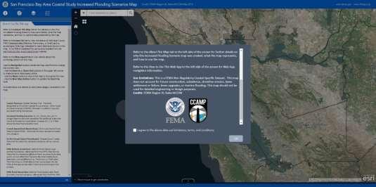
18 Region IX (Non-Disaster) Re-study the coastal flood, wave hazard, and associated risks for all 9 counties along the San Francisco Bay Issue draft floodplain mapping FEMA s Strategy Share draft mapping via Geoportal Provide an online comment tool Outcomes increased acceptance of the FEMA products and alerted FEMA to potential areas where additional attention may be required Reduced appeals Page 18

19 Region IX (Non-Disaster) Example: Geoplatform Increased Flood Scenario Page 19

20 Region IX (Non-Disaster) Flood Risk Review Tool Page 20


21 Region IV (Disaster) Support of Federal Partners during October 2015 flood event in South Carolina Issue EPA was trying to determine the flood zone for all their Superfund sites in the affected areas EPA asked FEMA for digital flood zone data for counties that were not in the NFHL FEMA s Strategy Direct EPA to Preliminary FIRM databases available through the MSC Requested work map files from the CTP contractor for a county that was scheduled for Preliminary issuance Outcomes Effective collaboration by sharing Best Available Data which included: draft Data Page 21

22 Region VI (Disaster) Guadalupe Blanco River basin in Central Texas Issue Severe flooding resulted in a disaster declaration for the area FEMA s Strategy Release Advisory Base Flood Elevation (ABFE) Maps Released Flood Risk Products Developed customized Notes to Users on each of the map product Outcomes Used by community officials to help guide rebuilding efforts Opened a dialogue with communities about mapping updates and minimized the chances for an appeal Page 22

23 Region VI (Disaster) ABFE Mapping Page 23

24 Region VI (Disaster) Estimated Flood Depth Mapping Page 24
25 Your Example Here Page 25
26 Best Strategies / Recommendations for FEMA
27 Best Strategy #1 Operate As-Is Regions would have the authority to release in-progress and provisional data at their discretion during the study process. Best Strategy #1 Recommendation Develop a decision support tool in conjunction with identified best practices to create better controls for shared data which may include: Purpose for sharing How the data should be delivered Who is responsible for delivering the data Selecting this Best Strategy could encourage greater consistency across FEMA when responding to data requests. Page 27
28 BS#1 Potential Questions for Decision Support Tool What is the current state of the data: (I) In Progress; (II) Provisional; (III) Preliminary; or (IV) Final/Effective? o Who is the primary requestor of the dataset? o Has the requestor provided justification for the data request? o Can the requestor wait until the data are Final? Or Effective? Is the data request in opposition with FEMA s Project? Are the data being requested to avoid/prevent an appeal or to enable an appeal of the Flood Risk Project? Would the use of the data be consistent with FEMA s Risk MAP program? Following release of the data, what is expected of FEMA or its contractor? How will FEMA manage communication with the requestor? Does FEMA expect the requestor to comment on the data? What process is set up for responding to comments? Have (Provider) budgets been secured to support the data request? Who will approve the data release? Are disclaimers needed? How will the data be transferred? How will the data be used? Will data be used to guide rebuilding efforts? Mitigation efforts? Floodplain management efforts? What is the potential benefit of sharing the data? Will sharing the data potentially delay project schedules and/or increase mapping costs? If so, how will FEMA mitigate that risk? Page 28
29 Best Strategy #2 Update and create new Guidance and Technical Reference documents Best Strategy #2 Update Guidance Documents Stakeholder Engagement: Data & Product Development A new work map guidance document to specify format, quality and content of a work map product to augment Riverine Mapping and Floodplain Guidance and in the Coastal Floodplain Mapping Guidance The Data Capture Technical Reference - Re: digital datasets vs. traditional maps Update the Metadata Profiles Technical Reference and Metadata Guidance documents Also o Consideration should be given to using the GeoPlatform as the delivery mechanism for the work map product. o Draft data Use Disclaimers and/or restrictions on use o effectively communicate the degree of uncertainty (TMAC) Page 29
30 Best Strategy #3 Develop a New Program Develop new program or working standard(s) that specify in-progress or provisional data delivery, quality, implementation, and use. Best Strategy Recommendations: A working standard that prohibits the release of in-progress data unless approved by the Regional FEMA Project Officer. A program standard that requires that provisional data be released only after a formal quality review, as determined by the study workflow process. A minimum 30-day comment period for the work map product or provisional data, following the Flood Risk Review meeting. Page 30
31 Memo Conclusions The following recommendations from the December 2015 Compass Memo FEMA should consider applying any new policy or polices related to sharing draft flood risk project data for all new studies Compass recommends BS#1 in the short-term until BS#3 can be fully implemented. Develop new program or working standard(s) similar to BS#3 and supporting guidance and technical references outlined in BS#2 Page 31
32 Review of Changes to the Policy for Flood Risk Analysis and Mapping June 6, 2006
33 Homeowner Flood Insurance Affordability Act of 2014 HFIAA Section 30. Mapping (abridged) The 2016 Spring update to the Policy for Flood Risk Analysis and Mapping implement elements of the mapping program defined by the Biggert Waters Flood Insurance Reform Act of 2012, as amended by the Homeowner Flood Insurance Affordability Act of 2014 A) before commencement of any map updating process, notify each community affected of the model or models to be used; B) provide each community affected a 30-day period beginning upon notification under subparagraph (A) to consult with the Administrator regarding the appropriateness; C) upon completion of the draft data products, transmit a copy to the affected community, provide the affected community a 30-day period to provide data to supplement or modify the existing data, and incorporate any consistent data. Page 33

34 FEMA Policy Standards for Flood Risk Analysis and Mapping FEMA Policy #FP (Rev 5) Risk MAP Spring/May 2016 Maintenance Cycle - Public Review Announcement in February day comment period Approved June 6, 2016 Page 34
35 ASFPM Comments on draft FEMA Policy ASFPM comments on the latest proposed changes to the Guidelines and Standards for spring 2016 There is an inherent value to sharing project data during data development and prior to preliminary issuance. vagueness of the language in the new 620 and 621 standards could be used to indefinitely delay the flood mapping process. The addition of two new comment periods also opens up mapping partners to additional costs standards should be written in a way that is understandable by mapping partners. Discovery process/study initiation and seems to be duplicative Provide clear terminology Page 35
36 FEMA Policy Update Standards for Flood Risk Analysis and Mapping - SID#620 SID #620 - FEMA should send written notification to community officials to inform them about engineering model(s) selected before starting the analysis for a flood risk study and provide a 30-day review period. Guidance Document Changes: Guidance for Stakeholder Engagement: Discovery Phase Guidance for Flood Risk Analysis and Mapping: Discovery Guidance for Stakeholder Engagement: Data and Document Development Phase Key Decision Points & KDP Form 1 added check as part of KDP 1 that confirms whether the 30-day review period has been provided to community Page 36
37 FEMA Policy Standards for Flood Risk Analysis and Mapping - SID#621 SID #621 - Requires provision of draft data to community officials, 30-day response period, and incorporation of appropriate data provided by community. Guidance Document Changes: Guidance for Stakeholder Engagement: Data and Document Development Phase; Revised to address the data submission notification to community officials Quality Review-added language regarding the 30-day review requirement prior to completion of QR1, and referenced reader to other guidance docs with more detail. Key Decision Points & KDP Form 2 added check as part of KDP 2 that confirms whether the 30-day review period has been provided to community Page 37
38 Preliminary Data KDP 1 30-Day Review Period KDP 2 30-Day Review Period Additional information/documentation CERC has prepared template letters Documents on Sharepoint Page 38
39 Proud Titanium Sponsor of the ASFPM 2016 Annual Conference Thank you for participating! Vince Geronimo, PE, CFM Krista Bethune Melnar, PE, CFM ASFPM 2016 Annual Conference GREAT LAKES GREAT PARTNERS Grand Rapids, Michigan, June 18 24
Flood Risk Review (FRR) Meeting. Cumberland County, Pennsylvania Carlisle, Pennsylvania December 5, 2016
 Meeting. Cumberland County, Pennsylvania Carlisle, Pennsylvania December 5, 2016") Flood Risk Review (FRR) Meeting Cumberland County, Pennsylvania Carlisle, Pennsylvania December 5, 2016 Why are we here today? The Flood Insurance Study (FIS) report and Flood Insurance Rate Maps (FIRMs)
Flood Risk Review (FRR) Meeting Cumberland County, Pennsylvania Carlisle, Pennsylvania December 5, 2016 Why are we here today? The Flood Insurance Study (FIS) report and Flood Insurance Rate Maps (FIRMs)
Kentucky Risk MAP It s not Map Mod II
 Kentucky Risk MAP It s not Map Mod II Risk Mapping Assessment and Planning Carey Johnson Kentucky Division of Water carey.johnson@ky.gov What is Risk MAP? Risk Mapping, Assessment, and Planning (Risk MAP)
LOCAL OFFICIALS MEETING Lake Wausau Physical Map Revision MARATHON COUNTY, WISCONSIN FEBRUARY 9, 2017
 LOCAL OFFICIALS MEETING Lake Wausau Physical Map Revision MARATHON COUNTY, WISCONSIN FEBRUARY 9, 2017 Welcome & Introduction Michelle Staff Floodplain Management Policy Coordinator, WDNR Michelle.Staff@Wisconsin.gov
Preliminary Work Map Release
 Coastal Mapping in New Jersey Preliminary Work Map Release Monmouth County, New Jersey June 14, 2013 Agenda Introduction and Purpose of Briefing Hurricane Sandy Advisory Base Flood Elevations Transitioning
David A. Stroud, CFM AMEC Earth & Environmental Raleigh, NC
 David A. Stroud, CFM AMEC Earth & Environmental Raleigh, NC Objectives Risk MAP background North Carolina s Risk MAP role Role of communication in Risk MAP Effective risk communication two examples Multi-hazard
Door County Floodplain Program Informational Meeting
 Door County Floodplain Program Informational Meeting Door County Land Use Services Department Wisconsin Department of Natural Resources January 15, 2018 Floodplain = Land affected by flood event with a
Cameron County, TX. Consultation Coordination Officer (CCO) Meeting. Please sign in (sheet at front of the room) Meeting will begin at 9:00
 Meeting. Please sign in (sheet at front of the room) Meeting will begin at 9:00") Cameron County, TX Consultation Coordination Officer (CCO) Meeting Please sign in (sheet at front of the room) Meeting will begin at 9:00 July 29, 2015 Lisa Jennings FEMA Region 6 Roles & Responsibilities
Cameron County, TX Consultation Coordination Officer (CCO) Meeting Please sign in (sheet at front of the room) Meeting will begin at 9:00 July 29, 2015 Lisa Jennings FEMA Region 6 Roles & Responsibilities
AGENDA. Floodplain Manager s Toolkit Unlocking the Hidden Potential of Floodplain Data for Your Community
 Floodplain Manager s Toolkit Unlocking the Hidden Potential of Floodplain Data for Your Community TFMA Spring Conference May 29, 2014 Jessica D. Baker, PE, CFM, PMP Samuel Amoako-Atta, GISP, CFM Eric Hajek,
9/20/2016. Orange County Preliminary FIRM / Consultation Coordination Officer (CCO) Meeting
 Meeting") Orange County Preliminary FIRM / Consultation Coordination Officer (CCO) Meeting Open Pacific Coast Study September 21 and 22, 2016 1 Welcome and Introductions Preliminary FIRM / CCO Meeting Orange County
Orange County Preliminary FIRM / Consultation Coordination Officer (CCO) Meeting Open Pacific Coast Study September 21 and 22, 2016 1 Welcome and Introductions Preliminary FIRM / CCO Meeting Orange County
Best Practices. for Incorporating Building Science Guidance into Community Risk MAP Implementation November 2012
 Best Practices for Incorporating Building Science Guidance into Community Risk MAP Implementation November 2012 Federal Emergency Management Agency Department of Homeland Security 500 C Street, SW Washington,
Flood Hazard Risk Mapping:
 Mitigation Division Flood Hazard Risk Mapping: Past, Present and Future Oklahoma Floodplain Management Association Ron Wanhanen, PE FEMA Region 6 Risk Analysis Branch Overview The Past The Present Risk
Bucks County, PA Flood Risk Review Meeting. November 2014
 Bucks County, PA Flood Risk Review Meeting November 2014 Agenda for Today Risk MAP Program overview Overview of non-regulatory Flood Risk Products and datasets Discuss mitigation action Technical overview
The National Flood Insurance Program and Flood Insurance Rate Map for San Francisco. Presentation at Treasure Island Community Meeting
 The National Flood Insurance Program and Flood Insurance Rate Map for San Francisco Presentation at Treasure Island Community Meeting October 17, 2007 1 National Flood Insurance Program (NFIP) Overview
Flood Risk Products. New Techniques for Identifying and Communicating Flood Risk
 Flood Risk Products New Techniques for Identifying and Communicating Flood Risk Mark Zito, GISP, CFM GIS Specialist Amol Daxikar, GISP, CFM Project Manager March 28, 2012 1% Flood with 3 Feet Sea Level
Oklahoma High Water Marks. CTP Community of Practice April 20, 2017
 Oklahoma High Water Marks CTP Community of Practice April 20, 2017 The Rains Came into Region 6 in May 2015 2 Disaster DR-4222 30 Day Rainfall 3 NOAA Rainfall Amounts / Rainfall Frequency 4 The Rains in
ASFPM Update and NFIP Reform. KAMM 10 th Anniversary Conference September 9, 2014
 ASFPM Update and NFIP Reform KAMM 10 th Anniversary Conference September 9, 2014 AND HE SAID Floods are 'acts of God,' but flood losses are largely acts of man. 1945 PhD Dissertation Human Adjustments
Floodplain Manager s Toolkit Unlocking the Hidden Potential of Floodplain Data for Your Community
 Floodplain Manager s Toolkit Unlocking the Hidden Potential of Floodplain Data for Your Community TFMA South Central Lunch Event San Antonio, TX June 12, 2014 Jessica D. Baker, PE, CFM, PMP Samuel Amoako-Atta,
Changes to the National Flood Insurance Program What to Expect
 Changes to the National Flood Insurance Program What to Expect Impact of changes to the NFIP under Homeowner Flood Insurance Affordability Act of 2014 More Changes are Coming to the NFIP On March 21, 2014,
Durham County Preliminary Flood Hazard Data Public Meeting. July 28, 2016
 Durham County Preliminary Flood Hazard Data Public Meeting July 28, 2016 Why Are We Here New flood hazard data has been released as Preliminary for Durham County Statutory Due Process for review/comments
National Coastal Outreach
 National Coastal Outreach Answering Tough Questions June 11, 2013 Why Focus on Coastal Flood Risk? 120,475,000 people or 39% of the U.S. population live in counties subject to the 1% annual chance coastal
Georgia Flood M.A.P. Program Risk MAP Plenary Session GAFM 2011
 Georgia Flood M.A.P. Program Risk MAP Plenary Session GAFM 2011 Collis Brown, Georgia DNR March 24, 2011 GA Flood Map Modernization Responsible for end-to-end production Developed aggressive outreach program
Changes to the National Flood Insurance Program What to Expect
 Changes to the National Flood Insurance Program What to Expect Impact of changes to the NFIP under Homeowner Flood Insurance Affordability Act of 2014 BW-12: What Changed Subsidies to be phased out Non-primary
CNMS and FOA: A Year in Review. Rick Sacbibit, P.E. Andy Read, CFM FEMA HQ, Risk Analysis Division June 4, 2015
 CNMS and FOA: A Year in Review Rick Sacbibit, P.E. Andy Read, CFM FEMA HQ, Risk Analysis Division June 4, 2015 Overview Current NVUE Status NVUE Cliff Update on CNMS Web Viewer CNMS Guidance Updates FOA
Southwest Florida Discovery Kick-Off Meeting. February 4, 2014
 Southwest Florida Discovery Kick-Off Meeting February 4, 2014 Agenda Introductions Outline Risk MAP products and datasets Project scoping and schedule Data gathered Next steps Gather stakeholder input/feedback
Abington Township Public Meeting
 Abington Township Public Meeting Flood Insurance Rate Map Update March 23, 2016 1 Meeting Agenda and Format Provide residents/property owners of Abington Township with information about the map update,
Location: Tampa, Florida March 6, 2013
 Discovery Meeting: West Florida Coastal Study Location: Tampa, Florida March 6, 2013 Agenda Introductions Why we are here Outline Risk MAP products and datasets Discovery Overview: Project scoping and
Consultation Coordination Officer (CCO) Meeting
 Meeting") Consultation Coordination Officer (CCO) Meeting Middle Brazos Lake Whitney Physical Map Revision Hill and McLennan Counties FEMA Region 6 Agenda National Flood Insurance Program Purpose of the Meeting
Consultation Coordination Officer (CCO) Meeting Middle Brazos Lake Whitney Physical Map Revision Hill and McLennan Counties FEMA Region 6 Agenda National Flood Insurance Program Purpose of the Meeting
National Flood Insurance Program. Jennifer Gilbert, CFM, ANFI New Hampshire NFIP State Coordinator
 National Flood Insurance Program Jennifer Gilbert, CFM, ANFI New Hampshire NFIP State Coordinator What is the National Flood Insurance Program? Created by Congress in 1968 Participating Communities voluntarily
Taylor County, Florida Community Coordination and Outreach (CCO) Meeting
 Meeting") Taylor County, Florida Community Coordination and Outreach (CCO) Meeting Suwannee River Water Management District April 26, 2017 11:00AM to 12:00PM Taylor County Administration Building, 201 E. Green Street,
Taylor County, Florida Community Coordination and Outreach (CCO) Meeting Suwannee River Water Management District April 26, 2017 11:00AM to 12:00PM Taylor County Administration Building, 201 E. Green Street,
Flood Risk Resilience in Alabama: Challenges and Successes
 Flood Risk Resilience in Alabama: Challenges and Successes Leslie A. Durham, P.E. Floodplain Management Branch Chief Alabama Office of Water Resources 10 Year Partnership with FEMA Flood Map Modernization
Meeting the Nation s Levee Challenges
 ASDSO USACE/FEMA Levee Discussion Meeting the Nation s Levee Challenges November 2015 Presenters: Richard Varuso, USACE Michael Bishop, FEMA 1 This Session s Objective KNOWLEDGE - Provide you with insight
Flood Plain Management Services (FPMS) Program
 Program") Flood Plain Management Services (FPMS) Program 2016 Winter Stakeholder Partnering Forum March 2016 Mario Beddingfield, P.E., CFM Hydraulic Engineer/FPMS Program Manager H&H/Water Control Branch U.S. Army
Flood Plain Management Services (FPMS) Program 2016 Winter Stakeholder Partnering Forum March 2016 Mario Beddingfield, P.E., CFM Hydraulic Engineer/FPMS Program Manager H&H/Water Control Branch U.S. Army
Orleans Parish, LA Initial Coordination Meeting Preliminary DFIRM Update September 29, 2011
 Orleans Parish, LA Initial Coordination Meeting Preliminary DFIRM Update September 29, 2011 Introductions Project History Description of Update Effort Project Benefits Project Schedule How You Can Help
BEING PREPARED FOR MAP CHANGES What to Know; What to Say National Flood Conference May 16, 2016
 BEING PREPARED FOR MAP CHANGES What to Know; What to Say National Flood Conference May 16, 2016 0 Discussion Topics Risk MAP Program Background Eric Simmons FEMA Region 9 Map Change Rating Options Edie
Preliminary DFIRM Community Coordination (PDCC) Meeting Gilchrist & Levy Counties, FL. April 30, 2015
 Meeting Gilchrist & Levy Counties, FL. April 30, 2015") Preliminary DFIRM Community Coordination (PDCC) Meeting Gilchrist & Levy Counties, FL April 30, 2015 Agenda 1. Introductions 2. Study Process and Timeline 3. Overview of Preliminary Products 4. Overview
Preliminary DFIRM Community Coordination (PDCC) Meeting Gilchrist & Levy Counties, FL April 30, 2015 Agenda 1. Introductions 2. Study Process and Timeline 3. Overview of Preliminary Products 4. Overview
THE $64,000 FLOOD INSURANCE BILL
 THE $64,000 FLOOD INSURANCE BILL GEORGIA ASSOCIATION OF FLOODPLAIN MANAGERS 9 TH ANNUAL TECHNICAL CONFERENCE Patrick Gervais, PE, CFM A CASE STUDY IN FLOOD INSURANCE This is a true story that happened
FEMA s Flood Map Modernization Preparing for FY09 and Beyond: Integrated Flood Data Update, Risk Assessment, and Mitigation Planning
 FEMA s Flood Map Modernization Preparing for FY09 and Beyond: Integrated Flood Data Update, Risk Assessment, and Mitigation Planning DRAFT CONCEPT PAPER June 1, 2007 Integrated Flood Data Update, Risk
Georgia Flood M.A.P. Program
 Georgia Flood M.A.P. Program Georgia Flood M.A.P. Program The Upper Chattahoochee River Basin Risk MAP Project Transitioning State Program to align with FEMA s Risk MAP Program Increase focus on risk assessment
ASFPM RECOMMENDED TASK FORCE ACTIONS
 Association of State Floodplain Managers, Inc. 2809 Fish Hatchery Road, Suite 204, Madison, WI 53713 Phone: 608-274-0123 Fax: 608-274-0696 Website: www.floods.org Email: asfpm@floods.org Federal Interagency
CITY OF PLANTATION ENGINEERING DEPARTMENT INTEROFFICE MEMORANDUM NO
 CITY OF PLANTATION ENGINEERING DEPARTMENT INTEROFFICE MEMORANDUM NO. 2013-003 DATE: October 22, 2012 TO: Mayor and Members of City Council FROM: Brett W. Butler, PE, CFM City Engineer SUBJECT: CRS Program
Updates to Maine Coastal Flood Insurance Rate Maps (FIRM s): What a Local Official Should Know. Presented by: Steve Johnson, P.E.
: What a Local Official Should Know. Presented by: Steve Johnson, P.E.") Updates to Maine Coastal Flood Insurance Rate Maps (FIRM s): What a Local Official Should Know Presented by: Steve Johnson, P.E. Town Engineer October 4, 2018 Introduction Federal Emergency Management
Updates to Maine Coastal Flood Insurance Rate Maps (FIRM s): What a Local Official Should Know Presented by: Steve Johnson, P.E. Town Engineer October 4, 2018 Introduction Federal Emergency Management
Nassau County, Florida Consultation Coordination Officer (CCO) Meeting. February 24, 2016 Fernandina Beach, Florida
 Meeting. February 24, 2016 Fernandina Beach, Florida") Nassau County, Florida Consultation Coordination Officer (CCO) Meeting February 24, 2016 Fernandina Beach, Florida Agenda Introductions Coastal Study Update Study Process and Timeline Flood Insurance Implications
Nassau County, Florida Consultation Coordination Officer (CCO) Meeting February 24, 2016 Fernandina Beach, Florida Agenda Introductions Coastal Study Update Study Process and Timeline Flood Insurance Implications
Kevin Wagner Maryland Department of the Environment
 Kevin Wagner Maryland Department of the Environment Topics Overview of the National Flood Insurance Program (NFIP) Mapping Regulations Insurance Mitigation Community Rating System (CRS) Questions Know
State of South Carolina Five-Year Floodplain Management Work Plan
 Purpose The purpose of the Community Assistance Program State Support Services Element (CAP-SSSE) is to provide, through a State grant mechanism, a means to ensure that communities participating in the
Use of FEMA Non regulatory Flood Risk Products in Planning
 Use of FEMA Non regulatory Flood Risk Products in Planning Georgia Association of Floodplain Managers Annual Conference March 24, 2016 What are the Non regulatory Flood Risk products? Go beyond the basic
Modernization, FEMA is Recognizing the connection between damage reduction and
 EXECUTIVE SUMMARY Every year, devastating floods impact the Nation by taking lives and damaging homes, businesses, public infrastructure, and other property. This damage could be reduced significantly
Tarrant County, TX Monthly Progress Report No. 33 (FEMA Contract No, HSFEHQ-09-D-0369) Task Order 01
 Task Order 01") Tarrant County, TX Monthly Progress Report No. 33 (FEMA Contract No, HSFEHQ-09-D-0369) Task Order 01 Period of Coverage: June 1, 2012 June 30, 2012 of Submittal: July 2, 2012 Submitted To: Ron Wanhanen
Tarrant County, TX Monthly Progress Report No. 33 (FEMA Contract No, HSFEHQ-09-D-0369) Task Order 01 Period of Coverage: June 1, 2012 June 30, 2012 of Submittal: July 2, 2012 Submitted To: Ron Wanhanen
Enough about me! Topics Covered
 About Me Worked in land surveying since 1997 Employed by the City of Orlando since 2006 City of Orlando City Surveyor since February 2015 Certified Floodplain Manager since 2015 Florida Licensed Surveyor,
USACE Levee Safety Meeting FEMA Overview
 USACE Levee Safety Meeting FEMA Overview Christine Gaynes, CFM FEMA Region V Roger Denick, PE, CFM FEMA Region V Service Center Agenda FEMA Region V Overview FEMA Levee Program Levee Guidance Transformation
Natchitoches Parish, Louisiana Flood Insurance Study Update Risk Analysis March 3, Shona Gibson Project Monitor, FEMA Region VI
 Natchitoches Parish, Louisiana Flood Insurance Study Update Risk Analysis Shona Gibson Project Monitor, FEMA Region VI Presentation Overview Introductions Why are we here? Levee Status and Opportunities
Non Regulatory Risk MAP Products Flood Depth and Probability Grids
 Non Regulatory Risk MAP Products Flood Depth and Probability Grids Virginia Floodplain Management Association 2015 Floodplain Management Workshop October 29th, 2015 Nabil Ghalayini, P.E., PMP, D.WRE, CFM
SECTION 9: MAPS AND DATA
 SECTION 9: MAPS AND DATA Contents 9.1. NFIP Maps and Data... 9-2 9.1.1. Adopting and enforcing NFIP floodplain maps and data... 9-2 9.1.2. Adopting and enforcing more restrictive data... 9-2 9.1.3. Annexations...
Association of State FloodPlain Managers 2809 Fish Hatchery Road, Madison, WI Phone: Fax:
 Association of State FloodPlain Managers 2809 Fish Hatchery Road, Madison, WI 53713 Phone: 608-274-0123 Fax: 274-0696 Website: www.floods.org Email: asfpm@floods.org Conference Call: FEMA-Washington and
This survey is expected to take approximately 20 minutes and must be completed in one session.
 Introduction Thank you for your willingness to participate in this online survey as part of the State Flood Assessment effort. This first step toward developing comprehensive flood planning for Texas does
FEMA s Flood Mapping Program
 FEMA s Flood Mapping Program Program Enhancements due to NFIP Reform and TMAC May 2, 2017 David Bascom, Engineering and Modeling Division, Risk Management Directorate FEMA s flood mapping program is in
Presentation Outline. Wimberley Witnessing the Flood. Wimberley & Home Memorial Weekend Flood. Observations/Comments
 Wimberley Witnessing the Flood Date: September 4, 2015 Presented by: John A. Espinoza, PE, CFM;MS Engineering Cindy Engelhardt, PE, CFM; lff Associates Mike Moya, PE, CFM; lff Associates Presentation Outline
Floodplain Management 101. Mississippi Emergency Management Agency Floodplain Management Bureau
 Floodplain Management 101 Mississippi Emergency Management Agency Floodplain Management Bureau Stafford Act The Stafford Disaster Relief and Emergency Assistance Act (Stafford Act) (Public Law 100-707)
Executive Director Deputy Director Director Emeritus Chad M. Berginnis, CFM Ingrid D. Wadsworth, CFM Larry A. Larson, P.E., CFM
 ASSOCIATION OF STATE FLOODPLAIN MANAGERS, INC. 575 D Onofrio Drive, Suite 200, Madison, Wisconsin 53719 www.floods.org Phone: 608-828-3000 Fax: 608-828-6319 asfpm@floods.org www.floods.org Executive Director
Outreach Georgia Flood M.A.P. Program. GAFM Technical Conference Flood Risk Outreach and Policy Session
 Outreach Georgia Flood M.A.P. Program GAFM Technical Conference Flood Risk Outreach and Policy Session 7 th Annual Technical Conference, Lanier Islands March 29, 2012 Risk Communication Key Learnings People
King County, WA DFIRM Update and Seclusion Process. Webinar June 14, 2016
 King County, WA DFIRM Update and Seclusion Process Webinar June 14, 2016 Agenda King County DFIRM Study History What is/has been done Process for moving forward Seclusion Seclusion mapping process Seclusion
FREQUENTLY ASKED QUESTION ABOUT FLOODPLAINS Michigan Department of Environmental Quality
 FREQUENTLY ASKED QUESTION ABOUT FLOODPLAINS Michigan Department of Environmental Quality WHAT IS A FLOOD? The National Flood Insurance Program defines a flood as a general and temporary condition of partial
ASFPM Partnerships for Statewide Mitigation Actions. Alicia Williams GIS and HMP Section Manager, Amec Foster Wheeler June 2016
 ASFPM Partnerships for Statewide Mitigation Actions Alicia Williams GIS and HMP Section Manager, Amec Foster Wheeler June 2016 Summary The Concept Leveraging Existing Data and Partnerships to reduce risk
State of Missouri Five-Year Floodplain Management Plan
 State of Missouri Five-Year Floodplain Management Plan Prepared By: Missouri Department of Public Safety State Emergency Management Agency Floodplain/Mitigation Section September 2004 INTRODUCTION Located
July 31, 2017 NFIP Flood Map Open House Flood Maps 101 Flood Mapping acronyms History of the NFIP Flood Mapping Updates Flood Insurance Fairhope,
 July 31, 2017 NFIP Flood Map Open House Flood Maps 101 Flood Mapping acronyms History of the NFIP Flood Mapping Updates Flood Insurance Fairhope, Alabama Flood Maps Fairhope Permitting Jurisdiction Coastal
ASFPM REGION 6 DIRECTOR ANNUAL REPORT. Annual Conference-Atlanta, Georgia
 ASFPM REGION 6 DIRECTOR ANNUAL REPORT Annual Conference-Atlanta, Georgia Jessica Baker, Regional Director 5/31/2015 ASFPM REGION 6 DIRECTOR ANNUAL REPORT Annual Conference-Atlanta, Georgia Region 6 Report
Federal Emergency Management Agency
 Page 1 of 6 Issue Date: September 27, 2010 Effective Date: February 14, 2011 Follows Conditional Case No.: 08-08-0873R DETERMINATION DOCUMENT COMMUNITY AND REVISION INFORMATION PROJECT DESCRIPTION BASIS
Planning Process---Requirement 201.6(b): An open public involvement process is essential to the development of an effective plan.
: An open public involvement process is essential to the development of an effective plan.") Section 3 Capability Identification Requirements Planning Process---Requirement 201.6(b): An open public involvement process is essential to the development of an effective plan. Documentation of the Planning
Section 3 Capability Identification Requirements Planning Process---Requirement 201.6(b): An open public involvement process is essential to the development of an effective plan. Documentation of the Planning
ADVISORY BASE FLOOD ELEVATIONS (ABFEs)
") The Department of Homeland Security s Federal Emergency Management Agency is committed to helping communities that were impacted by Hurricanes Katrina and Rita rebuild safer and stronger. Following catastrophic
The Department of Homeland Security s Federal Emergency Management Agency is committed to helping communities that were impacted by Hurricanes Katrina and Rita rebuild safer and stronger. Following catastrophic
This survey is expected to take approximately 20 minutes and must be completed in one session.
 State Flood Assessment Survey 1 Introduction Thank you for your willingness to participate in this online survey as part of the State Flood Assessment effort. This first step toward developing comprehensive
Piloting LAMP from Stream to Sea
 Piloting LAMP from Stream to Sea FEMA s New Analysis and Mapping Procedures for Non-Accredited Levee Systems Presented by: Eric Simmons, CFM Senior Engineer, FEMA Region IX Presentation Outline Levee Issues
On March 21, 2014, President Obama signed the Homeowner Flood Insurance Affordability Act of 2014 into law.
 On March 21, 2014, President Obama signed the Homeowner Flood Insurance Affordability Act of 2014 into law. This law repeals and modifies certain provisions of the Biggert-Waters Flood Insurance Reform
Accounting for Long-Term Erosion and Sea Level Rise in New England: A TMAC Recommendation
 Accounting for Long-Term Erosion and Sea Level Rise in New England: A TMAC Recommendation Elena Drei-Horgan, PhD, CFM Jeremy Mull, PE Brian Caufield, PE May 2017 Establishment of TMAC, Definition, Members
210 W Canal Dr Palm Harbor, FL 34684
 Flood Analysis Memo Property Address In Partnership with: ** This property is within a high risk flood zone ** BFE = 6 ft This property is located in the FEMA designated high-risk zone, Zone AE - an area
Table 1: Federal, State and Local Government Rules applicable to LOMRs/CLOMRS submittal
 MnDNR LOMC Guide This document has been prepared by the Minnesota Department of Natural Resources floodplain staff and is intended to provide assistance with LOMR/CLOMR submittals. This information is
REAL ESTATE FLOOD DISCLOSURE PROGRAM & FLOOD MAP INFORMATION SERVICES
 REAL ESTATE FLOOD DISCLOSURE PROGRAM & FLOOD MAP INFORMATION SERVICES Lisa Foster, CFM, Floodplain Coordinator ldfoster@pinellascounty.org January 26, 2018 Why are you here? Save your clients money on
REAL ESTATE FLOOD DISCLOSURE PROGRAM & FLOOD MAP INFORMATION SERVICES
 REAL ESTATE FLOOD DISCLOSURE PROGRAM & FLOOD MAP INFORMATION SERVICES Agenda 10:30-12:00 Flood Disclosure Program 12:00-12:30 Lunch 12:30-1:30 Flood Map Service Center Lisa Foster, CFM, Floodplain Coordinator
Changes to the National Flood Insurance Program: From Biggert to Grimm Waters. Click to edit Master title style. Click to edit Master subtitle style
 Changes to the National Flood Insurance Program: Click to edit Master title style From Biggert to Grimm Waters Click to edit Master subtitle style Thomas Ruppert Coastal Planning Specialist With thanks
Georgia Flood M.A.P. Program
 ASFPM 2013 Conference Remembering the Past - Insuring the Future June 9-14, 2013 Georgia Flood M.A.P. Program Tom Shillock, CFM Georgia Floodplain Management Unit Coordinator George Thompson IV, CFM GIS
Flood Hazard Demographics and NFIP Policy/Claims Analysis
 Flood Hazard Demographics and NFIP Policy/Claims Analysis ASFPM - Hartford, CT June 2013 Mohan Rajasekar Mark Crowell Andy Neal Problem Statement NFIP A means of discouraging unwise occupancy of flood
Flood Risk Assessment in the
 Georgia Flood M.A.P. Program Flood Risk Assessment in the Upper Chattahoochee h h River Basin GAFM Annual Conference March 28, 2012 Agenda Map Mod to Risk MAP (Georgia Flood M.A.P.) transition Flood Risk
Federal Emergency Management Agency
 Page 1 of 5 Issue Date: June 21, 2013 Follows Conditional Case No.: 04-06-A148R DETERMINATION DOCUMENT COMMUNITY COMMUNITY AND REVISION INFORMATION City of Irving Dallas County Texas FILL PROJECT DESCRIPTION
New Tools for Mitigation & Outreach. Louie Greenwell Stantec
 New Tools for Mitigation & Outreach Louie Greenwell Stantec Our Discussion Today Background What is Risk MAP? FEMA Products Overview of RiskMAP Data Sets Changes Since Last FIRM Depth and Analysis Grids
What Was Updated in 2004 in Hennepin Countywide Maps?
 What Was Updated in 2004 in Hennepin Countywide Maps? Combined the city and township maps into one countywide index Done by USACE Mainly digital capture of old floodplain boundaries; some spots with shifts
Sea Level Rise and the NFIP
 Cheryl A Johnson, PE, CFM, PMP March 26, 2014 http://www.globalchange.gov/ Sea-level rise and the likely increase in hurricane intensity and associated storm surge will be among the most serious consequences
National Flood Insurance Program BW-12
 National Flood Insurance Program BW-12 Janice Mitchell, Insurance Specialist, Floodplain Management and Insurance Branch FEMA, Region 4 Janice.mitchell@fema.dhs.gov Biggert-Waters 2012 - What Everyone
St. Johns County, Florida Consultation Coordination Officer (CCO) Meeting. August 31, 2016 St. Augustine, Florida
 Meeting. August 31, 2016 St. Augustine, Florida") St. Johns County, Florida Consultation Coordination Officer (CCO) Meeting August 31, 2016 St. Augustine, Florida Agenda Introductions Coastal Study Update Study Process and Timeline Flood Insurance Implications
St. Johns County, Florida Consultation Coordination Officer (CCO) Meeting August 31, 2016 St. Augustine, Florida Agenda Introductions Coastal Study Update Study Process and Timeline Flood Insurance Implications
Flood Analysis Memo. 629 Orangewood Dr. Dunedin, FL BFE = 21 ft
 Flood Analysis Memo Property Address 629 Orangewood Dr. In Partnership with: ** This property is NOT within a high-risk flood zone ** 629 Orangewood Dr. BFE = 21 ft This property is located in the FEMA
New Jersey Department of Environmental Protection. Five-Year Floodplain Management Work Plan
 New Jersey Department of Environmental Protection Five-Year Floodplain Management Work Plan September 30, 2004 I. State Authority New Jersey Department of Environmental Protection Five-Year Floodplain
Flood Mitigation Planning at the Texas Water Development Board. Josh Oyer, CFM December 7, 2016
 Flood Mitigation Planning at the Texas Water Development Board Josh Oyer, CFM December 7, 2016 1 Topics TWDB Flood Mitigation Planning overview NFIP Community Assistance Program Federal and State Grants
Challenges and Risks to the Bay Area Maritime and Industrial Economy
 Challenges and Risks to the Bay Area Maritime and Industrial Economy Flood Management Challenges Ed Curtis, P.E., Risk Analysis Branch, FEMA Region IX Gregor Blackburn, CFM, Floodplain Management & Insurance
The Changing NFIP, the CRS & Local Governments. Scott Pippin, J.D., M.E.P.D.
 The Changing NFIP, the CRS & Local Governments Scott Pippin, J.D., M.E.P.D. Flood Insurance Reform Biggert Waters 2012 (BW12) Homeowner Flood Insurance Affordability Act of 2014 (HFIAA) Bigger Waters 2012
Thurston County, WA Flood Hazard Mitigation Plan Annual Progress Report CRS Activity 510
 Thurston County, WA Flood Hazard Mitigation Plan Annual Progress Report CRS Activity 510 Reporting Period: ctober 1, 2014 to September 30, 2015 Background: Thurston County developed a flood hazard mitigation
SUPERHERO!!! Elevation Certificate. You are about to go from SURVEYOR 2/18/2019
 Karol L. Grove Licensed Professional Surveyor Certified Floodplain Manager Elevation Certificate No longer the Animal it used to be When are they needed??? You are about to go from SURVEYOR to SUPERHERO!!!
10526 Bermuda Isle Dr. Tampa, FL 33647
 Flood Analysis Memo Property Address In Partnership with: ** This property is NOT within a high-risk flood zone ** This property is located in a FEMA low-risk zone designated as Zone X - an area of minimal
Delaware Bay / River Coastal Flood Risk Study. FEMA REGION II and III September 19, 2012
 Delaware Bay / River Coastal Flood Risk Study FEMA REGION II and III September 19, 2012 Agenda Risk MAP Program Overview Risk MAP Non-Regulatory Products & Datasets Region II New Jersey Coastal Flood Study
Flood Risk Report. Guadalupe Blanco River Basin. October 2016
 Flood Risk Report Guadalupe Blanco River Basin Upper Guadalupe, Middle Guadalupe, San Marcos, and Lower Guadalupe (HUC8s 12100201-12100204) October 2016 [Type here] [Type here] [Type here] Flood Risk Report
Are Risk MAP Products Really on Our Mind?
 Are Risk MAP Products Really on Our Mind? ASFPM 2015 Atlanta, GA Presented By: Jason Wilson, PE, CFM William Fain, EIT, CFM Amec Foster Wheeler Presentation Overview 1. What is Risk MAP/What are Risk Map
FLOODPLAIN MANAGEMENT EFFORTS IN THE SANTA CLARA RIVER WATERSHED
 FLOODPLAIN MANAGEMENT EFFORTS IN THE SANTA CLARA RIVER WATERSHED DIGITAL FLOOD INSURANCE MAP (DFIRM) UPDATES LEVEE CERTIFICATION FEMA FLOOD INSURANCE STUDY (Santa Clara River) Present to: Santa Clara River
Terri L Turner, AICP, CFM; Region 4 Director
 ASSOCIATION OF STATE FLOODPLAIN MANAGERS Region IV Report 2012-2013 (AL, FL, GA, KY, MS, NC, SC, TN) ASFPM Annual Conference / Board Meeting Hartford, CT May 2013 Terri L Turner, AICP, CFM, Region IV Director
Changes to the National Flood Insurance Program: From Biggert-Waters. to Grimm-Waters. Click to edit Master title style
 Changes to the National Flood Insurance Program: From Biggert-Waters Click to edit Master title style to Grimm-Waters Click to edit Master subtitle style Thomas Ruppert Coastal Planning Specialist Florida