C o p e r n i c u s E m e r g e n c y M a n a g e m e n t S e r v i c e f o r R i s k p l a n n i n g a n d R e c o v e r y
|
|
|
- Toby Lane
- 5 years ago
- Views:
Transcription

1 C o p e r n i c u s E m e r g e n c y M a n a g e m e n t S e r v i c e f o r R i s k p l a n n i n g a n d R e c o v e r y Copernicus Service Copernicus EU Copernicus EU Copernicus EU

2 Copernicus C o p e r n i c u s E M S - c o m p o n e n t s 2

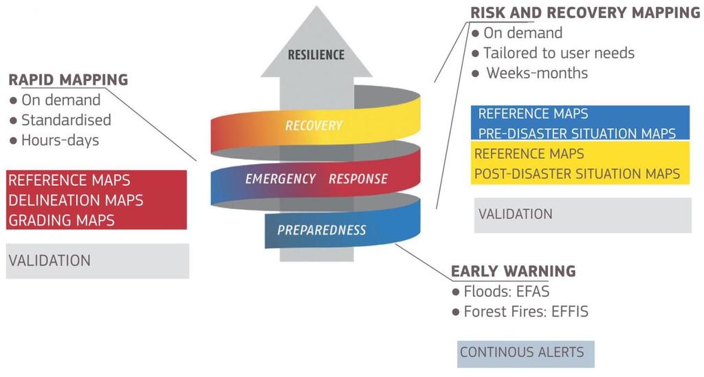
3 M a p T y p e s Three types of map are provided by the EMS Risk & Recovery Mapping Service: Reference maps provide a comprehensive and updated knowledge of the territory and relevant assets in a disaster risk reduction context Pre-disaster situation maps provide thematic information supporting planning for contingencies on vulnerable areas. Examples include hazard exposure, vulnerability, resilience, risk status, evacuation plans and modelling scenarios Post-disaster situation maps provide thematic information in support of post-disaster activities such as reconstruction planning and progress monitoring. Examples include post-disaster needs assessment, recovery plans, reconstruction/rehabilitation monitoring, including Internally Displaced Persons (IDP) and refugee camps monitoring 3
 Land cover & Physiography Rivers Railways Toponyms Woodland Canals Roads Administrative Natural vegetation Lakes")

4 Typical key features R e f e r e n c e M a p Legend Hydrology Transport Population-related (incl. Industry & Utilities) Land cover & Physiography Rivers Railways Toponyms Woodland Canals Roads Administrative Natural vegetation Lakes Cart tracks boundaries Cropland Reservoirs Bridges Built-up areas Grassland Open Water River crossing Settlements Scrub Shorelines points Processing / Bare soil Dams Airfields industrial plants Snow/Ice Wells Runways Pipelines Floodplains Ponds Ports Power lines Void Areas Power stations Contours, spot heights Cliffs 4


5 Application examples P r e - D i s a s t e r S i t u a t i o n M a p Legend Hazard exposure Vulnerability and resilience of buildings or people Risk status for population and assets Evacuation plan Probabilistic risk assessment based on likely hazards 5

6 Application examples P o s t - D i s a s t e r S i t u a t i o n M a p Legend Changes of Vulnerability and resilience of urban settlements Risk status for new assets Post-disaster needs assessment Recovery plans Reconstruction/rehabilitation monitoring 6

7 R R M : T h e S e r v i c e s i n c e 2012 The Risk and Recovery Mapping service has been activated 33 times since the beginning of the service Member states triggering, since 2012 are: Greece, Portugal, Germany. Many activation were triggered by DG JRC, DG ECHO or associated users A call for Expression of Interest was launched on March 2017 (closed on 30 April), addressing global stakeholders in the field of disaster management and civil protection and members of NGO s working in the humanitarian field, resulting in an significant increase in activation number

8 H o w t o a c c e s s t h e R R M S e r v i c e The Service can be directly activated by nominated Authorised Users (AU) Entities which are not Authorised Users and who wish to activate the Mapping service must contact their National Focal Point or contact the ERCC All Commission Services and the European External Action s Situation room are Authorized Users The AU must fill the Services Request Form (SRF) and send by e- mail to the ERCC More information on the Mapping service at Contact ERCC at echo-ercc@ec.europa.eu if you want to activate the EMS mapping 8
9 T i m e l i n e s s After receipt of Technical Annex the Service Providers (SP) have the following deadlines: 7 working days for questions 10 working days for sending an offer JRC: evaluation(3days), preparation of contract (5days) SP: 20working days from contract signature 7 d questions 10 d proposal preparation 3 d JRC evaluation 5 d contract preparation 20 d map compilation 9
10 D e l i v e r y p a c k a g e Typical example of product delivery (forest fire in Portugal) Product number Type of product Product name Scale No of maps 1 Pre-event maps Rference 1: : LULC 11 3 Post event maps Forest fire delineation and grading 11 4 Erosion risk 11 5 Landslide risk 11 6 Loss assessment 1: : csv and metadata Geodatabase (gdb) Final report Field work results 10


11 R R M : S o m e e x a m p l e s Floods Bolivia : vulnerability maps Earthquake reconstruction monitoring in Haiti Risk assessments for earthquake preparedness, mitigations, etc.. Nepal Forest fires Erosion risk maps, land slide risk maps, bio-mass losses Humanitarian aid Population density estimates and land use database Environmental degradation around refugee camps This map of Rio Mamore, Bolivia, highlight the existing and proposed measures for flood defense and was delivered as part of a series of maps dealing with pre-disaster preparedness and vulnerability analysis in the region 11

12 E M S N : B a s i c E u r o p e a n A s s e t s M a p This RRM activation has been requested by the BBK (Bundesamt fuer Bevoelkerungsschutz und Katastrophenhilfe), Federal Office of Civil Protection and Disaster Assistance The target of the activation is to generate a detailed asset-map for Germany, expressing values in EURO/m2. Assets have been shown not only as cumulative layer of different types of assets (e.g. private households, industry, commerce, vehicles, agriculture, etc.), but as accessible single contributing layers as well, each of them expressing its value in EURO/m2 Intended use of the maps is to contribute to the national risk assessment in Germany. It is a highly appreciated product as input for multi-risk and vulnerability maps The geographic extent covers the national territory of Germany


13 E M S N : B a s i c E u r o p e a n A s s e t s M a p Legend BEAM Basic European Assets Map has been provided over the whole territory of Germany
 in 50 years (2013 2063).")

14 E M S N : E a r t h q u a k e r i s k a s s e s s m e n t A u s t r i a P l a n n i n g a n d R e c o v e r y Austria is situated in a region of low to moderate seismic hazard, reported as 10% probability of ground motion exceeding g PGA (Peak ground acceleration) in 50 years ( ). Despite this moderate hazard levels the current estimation of seismic risk is high The service implementation, refers to the analysis of the potential impact of earthquake activity including a number of secondary hazards, namely: Landslide prone areas in built up areas Flood Risk originating from upstream blocked rivers Industrial Accidents


15 E M S N : E X P O S U R E ( P o p u l a t i o n ) Legend Population exposure is realized in grid format of 500m, calculating the population density per grid cell Seismic hazard and population exposure mapping depicts the population density in grid format categorized in five different classes (Very Low, Low, Medium, High, and Very High) 15


16 E M S N : V u l n e r a b i l i t y Estimation of buildings' vulnerability Assessment of the seismic vulnerability of electrical, gas and oil utilities network Legend The vulnerabilities have been classified in five different categories (very low, low, medium, high, very high) 16
, to elaborate Risk Assessment products and to propose Mitigation Measures The area analyzed is the")

17 E M S N : B u l g a r i a : P o s t - d i s a s t e r a n a l y s i s The objective of the activation is to provide Post Disaster assessment of the key dynamics of the 2014 flood in the area and the resulted damages (sectorial), to elaborate Risk Assessment products and to propose Mitigation Measures The area analyzed is the Mizia town (Vratsa region), falling in the Skat River Basin, where significant surface run off occurred in 2014 as a consequence of heavy precipitations registered from 31 July to 2 August 2014 (70 up to 220 mm. almost as much as 50%of the average annual precipitation within the Danube plain) GLIDE NUMBER: F L B G R
 GIS")


18 E M S N : P o p u l a t i o n at R i s k - V r a t s a Standard (aggregation) GIS techniques were applied at the census data layer, to produce information on population at district, community & block levels Assets at risk identified focussing on population and infrastructures 18


19 R R M a c t i v i t i e s i n S w e d e n 3 RRM activations, 1 accepted Mapping possible oil spill Client: Haparanda municipality Date: Event: Possible Oil spill Type: Non Rush Mode Response: Not accepted Client: Västerås municipality Date: Event: Possible Oil spill Type: Non Rush Mode Response: Accepted Client: Eskilstuna municipality Date: Event: Possible Oil spill Type: Non Rush Mode Response: Not accepted
20 RRM r e l e v a n t t h e m a t i c f o r S w e d e n Risk assessment Flood Forest fire Oil spill Transportation at risk (landslide, avalanche) Basic European Assets Map for Sweden Climate vulnerability


21 P o s s i b l e a c t i v a t i o n Mapping drought in South East Sweden Water Scarcity Limited access to water Ban on watering plants and crops Estimated basin storage Radar analysis from helicopter.
22 A c t i v a t i o n r e q u e s t s : Visit the Swedish Copernicus EMS website: 1index.html For questions or an activation request please contact: MSB via Phone: or gis@msb.se
23 C o n t a c t To access the Copernicus EMS Risk & Recovery Mapping Portal go to To navigate and view the RRM activations go to 23
BACKGROUND When looking at hazard and loss data for future climate projections, hardly any solid information is available.
 BACKGROUND Flooding in Europe is a peak peril that has the potential to cause losses of over 14 billion in a single event. Most major towns and cities are situated next to large rivers with large amounts
ANNEX B: TOWN OF BLUE RIVER
 ANNEX B: TOWN OF BLUE RIVER B.1 Community Profile Figure B.1 shows a map of the Town of Blue River and its location within Summit County. Figure B.1. Map of Blue River Summit County (Blue River) Annex
Project Fiche IPA centralised programmes Regional Programme on Disaster Risk Reduction in South-East Europe
 Project Fiche IPA centralised programmes Regional Programme on Disaster Risk Reduction in South-East Europe 1. Basic information 1.1 CRIS Number: 2008/019-813 and 2008/020-047 1.2 Title: Disaster Risk
Background and context of DRR and GIS
 Mainstreaming DRR into National Plan, Policies and Programmes in Nepal Present to: Regional Workshop on Geo-referenced Disaster Risk Management information System in South and South West Asia and Central
REPUBLIC OF BULGARIA
 REPUBLIC OF BULGARIA DISASTER RISK REDUCTION STRATEGY INTRUDUCTION Republic of Bulgaria often has been affected by natural or man-made disasters, whose social and economic consequences cause significant
NFIP Program Basics. KAMM Regional Training
 NFIP Program Basics KAMM Regional Training Floodplain 101 Homeowners insurance does not cover flood damage Approximately 25,000 flood insurance policies in KY According to BW12 analysis, approximately
EUROPEAN COMMISSION DIRECTORATE-GENERAL HUMANITARIAN AID AND CIVIL PROTECTION - ECHO. Summary Report
 EUROPEAN COMMISSION DIRECTORATE-GENERAL HUMANITARIAN AID AND CIVIL PROTECTION - ECHO ECHO A - Strategy, Policy and International Co-operation A/3 - Policy and Implementation Frameworks Brussels 23 April
G318 Local Mitigation Planning Workshop. Module 2: Risk Assessment. Visual 2.0
 G318 Local Mitigation Planning Workshop Module 2: Risk Assessment Visual 2.0 Unit 1 Risk Assessment Visual 2.1 Risk Assessment Process that collects information and assigns values to risks to: Identify
Skardu, Pakistan. Local progress report on the implementation of the Hyogo Framework for Action (First Cycle)
") Skardu, Pakistan Local progress report on the implementation of the Hyogo Framework for Action (First Cycle) Name of focal point: Habib Mughal Organization: UN-HABITAT - Pakistan Title/Position: Manager
Skardu, Pakistan Local progress report on the implementation of the Hyogo Framework for Action (First Cycle) Name of focal point: Habib Mughal Organization: UN-HABITAT - Pakistan Title/Position: Manager
Emergency Management. December 16, 2010
 Applications of Hazus-MH for Emergency Management December 16, 2010 What is Hazus-MH? Free ArcGIS extension Facilitates a risk-based approach to mitigation Identifies and visually displays hazards and
Czech Republic. National progress report on the implementation of the Hyogo Framework for Action ( )
") Czech Republic National progress report on the implementation of the Hyogo Framework for Action (2011-2013) Name of focal point: Organization: Title/Position: E-mail address: Marie Adamkova/Matyas Doul
Czech Republic National progress report on the implementation of the Hyogo Framework for Action (2011-2013) Name of focal point: Organization: Title/Position: E-mail address: Marie Adamkova/Matyas Doul
Natural Hazards Risk Mapping in Sweden ISDR
 Natural Hazards Risk Mapping in Sweden ISDR Barbro Näslund-Landenmark Ecologist, Senior advisor Swedish Rescue Services Agency Department of emergency prevention Section for environment, planning and building
Non Regulatory Risk MAP Products Flood Depth and Probability Grids
 Non Regulatory Risk MAP Products Flood Depth and Probability Grids Virginia Floodplain Management Association 2015 Floodplain Management Workshop October 29th, 2015 Nabil Ghalayini, P.E., PMP, D.WRE, CFM
The 2004 Gilbert F. White National Flood Policy Forum September 21-22, 2004 FLOOD STANDARDS IN FOREIGN COUNTRIES
 The 2004 Gilbert F. White National Flood Policy Forum September 21-22, 2004 FLOOD STANDARDS IN FOREIGN COUNTRIES Firas Makarem, Dewberry, International Committee Chair, Association of State Floodplain
Introduction to the Disaster Risk Profile of Chittagong
 Introduction to the Disaster Risk Profile of Chittagong subir Das Focal Person Youth Issue Young Power in Social Action (YPSA) Cell: +01716692292 Email: subir18bd@yahoo.com Chittagong at a Glance 2nd largest
COMMISSION OF THE EUROPEAN COMMUNITIES
 EN EN EN COMMISSION OF THE EUROPEAN COMMUNITIES Brussels, 23.2.2009 COM(2009) 82 final COMMUNICATION FROM THE COMMISSION TO THE EUROPEAN PARLIAMENT, THE COUNCIL, THE EUROPEAN ECONOMIC AND SOCIAL COMMITTEE
Planning Process---Requirement 201.6(b): An open public involvement process is essential to the development of an effective plan.
: An open public involvement process is essential to the development of an effective plan.") Section 3 Capability Identification Requirements Planning Process---Requirement 201.6(b): An open public involvement process is essential to the development of an effective plan. Documentation of the Planning
Section 3 Capability Identification Requirements Planning Process---Requirement 201.6(b): An open public involvement process is essential to the development of an effective plan. Documentation of the Planning
Flood risk assessment for sustainable urban development : Case study of Marikina-Pasig-San Juan river basin, Manila
 International Conference in Urban and Regional Planning "Planning towards Sustainability and Resilience" 14 15 March, 2018 Manila, Philippines Flood risk assessment for sustainable urban development :
in the EU A new EU legal context on the assessment and management of flood water.europa.eu Maria Brättemark, WFD Team, DG ENV.D.1, European Commission
 Setting the scene : Flood Risk Management in the EU A new EU legal context on the assessment and management of flood risks Maria Brättemark, WFD Team, DG ENV.D.1, European Commission water.europa.eu This
Karlstad, Sweden. Local progress report on the implementation of the 10 Essentials for Making Cities Resilient ( )
") Karlstad, Sweden Local progress report on the implementation of the 10 Essentials for Making Cities Resilient (2013-2014) Mayor: Ulf Nyqvist Name of focal point: -Anna -Sjödin Organization: -Karlstad Municipality
Karlstad, Sweden Local progress report on the implementation of the 10 Essentials for Making Cities Resilient (2013-2014) Mayor: Ulf Nyqvist Name of focal point: -Anna -Sjödin Organization: -Karlstad Municipality
Science for DRM 2020: acting today, protecting tomorrow. Table of Contents. Forward Prepared by invited Author/s
 : acting today, protecting tomorrow Table of Contents Forward Prepared by invited Author/s Preface Prepared by DRMKC Editorial Board Executive Summary Prepared by Coordinating Lead Authors 1. Introduction
Perspectives on Earthquake Risk Assessment and Management in Trinidad and Tobago
 Perspectives on Earthquake Risk Assessment and Management in Trinidad and Tobago Jacob Opadeyi Professor and Head Department of Geomatics Engineering and Land Management, The University of the West Indies,
Sreeja S. Nair UNDP INDIA
 Sreeja S. Nair UNDP INDIA Potential Uses of Disaster Databases Pre-disaster Phase Develop a simple disaster risk indexing system that tracks the patterns of disaster risk - spatially and temporally. Develop
Hazard Mitigation FAQ
 Hazard Mitigation FAQ What is Hazard Mitigation? Actions taken to reduce or eliminate the long-term risk to people, property, or the environment from hazards and their effects. Examples: Hazardous Area
SECTOR ASSESSMENT (SUMMARY): FINANCE (DISASTER RISK MANAGEMENT) 1. Sector Performance, Problems, and Opportunities
: FINANCE (DISASTER RISK MANAGEMENT) 1. Sector Performance, Problems, and Opportunities") National Disaster Risk Management Fund (RRP PAK 50316) SECTOR ASSESSMENT (SUMMARY): FINANCE (DISASTER RISK MANAGEMENT) A. Sector Road Map 1. Sector Performance, Problems, and Opportunities a. Performance
National Disaster Risk Management Fund (RRP PAK 50316) SECTOR ASSESSMENT (SUMMARY): FINANCE (DISASTER RISK MANAGEMENT) A. Sector Road Map 1. Sector Performance, Problems, and Opportunities a. Performance
Government Decree on Flood Risk Management 659/2010
 Ministry of Agriculture and Forestry, Finland NB: Unofficial translation; legally binding texts are those in Finnish and Swedish. Government Decree on Flood Risk Management 659/2010 Section 1 Preliminary
Garfield County NHMP:
 Garfield County NHMP: Introduction and Summary Hazard Identification and Risk Assessment DRAFT AUG2010 Risk assessments provide information about the geographic areas where the hazards may occur, the value
Priority Area 5: To Manage Environmental Risks Péter Bakonyi & Petra Szávics Hungary Romania
 Priority Area 5: To Manage Environmental Risks Péter Bakonyi & Petra Szávics Hungary Romania Outline Structure of the EUSDR Priority Area 5 Presentation of the issue Danube Region Specifics Actions Targets
Mapping Flood Risk in the Upper Fox River Basin:
 Mapping Flood Risk in the Upper Fox River Basin: Vulnerable Populations and Adverse Health Effects Presented by: Angelina Hanson STUDY AREA: Wisconsin's Upper Fox River Basin Total Population 139,309.
Modernization, FEMA is Recognizing the connection between damage reduction and
 EXECUTIVE SUMMARY Every year, devastating floods impact the Nation by taking lives and damaging homes, businesses, public infrastructure, and other property. This damage could be reduced significantly
Catastrophe Risk Modelling. Foundational Considerations Regarding Catastrophe Analytics
 Catastrophe Risk Modelling Foundational Considerations Regarding Catastrophe Analytics What are Catastrophe Models? Computer Programs Tools that Quantify and Price Risk Mathematically Represent the Characteristics
Kathmandu, Nepal. Local progress report on the implementation of the Hyogo Framework for Action (First Cycle)
") Kathmandu, Nepal Local progress report on the implementation of the Hyogo Framework for Action (First Cycle) Name of focal point: Devendra Dongol Organization: Kathmandu Metropolitan City Title/Position:
Kathmandu, Nepal Local progress report on the implementation of the Hyogo Framework for Action (First Cycle) Name of focal point: Devendra Dongol Organization: Kathmandu Metropolitan City Title/Position:
Southwest Florida Healthcare Coalition
 Southwest Florida Healthcare Coalition Hazards Vulnerability Assessment 2018 1 Table of Contents Summary 3 EmPower Maps and Data 5 Social Vulnerability Index Maps 19 Suncoast Disaster Healthcare Coalition
Skardu, Pakistan. Local progress report on the implementation of the 10 Essentials for Making Cities Resilient (First Cycle)
") Skardu, Pakistan Local progress report on the implementation of the 10 Essentials for Making Cities Resilient (First Cycle) Name of focal point: Habib Mughal Organization: UN-HABITAT - Pakistan Title/Position:
Skardu, Pakistan Local progress report on the implementation of the 10 Essentials for Making Cities Resilient (First Cycle) Name of focal point: Habib Mughal Organization: UN-HABITAT - Pakistan Title/Position:
MANAGING FLOOD AND WATER-RELATED RISKS: A CHALLENGE FOR THE FUTURE
 MANAGING FLOOD AND WATER-RELATED RISKS: A CHALLENGE FOR THE FUTURE Tarek MERABTENE, Junichi YOSHITANI and Daisuke KURIBAYASHI Public Works Research Institute (PWRI), 1-6 Minamihara, 305-8516Tsukuba, Japan
To protect their property
 Organization National government MSB Swedish civil contingencies agency County administrative board of Skåne Interest MSB works: via knowledge enhancement, support, training, exercises, regulation, Coordinate
From 152/06 national law to flood directive. Marcello Brugioni Arno River Basin Authority, IT
 From 152/06 national law to flood directive Marcello Brugioni Arno River Basin Authority, IT Italy and the management of floods SerchioVersilia, River, 2010 Firenze, 1966 1996 Sarno, 1998 Polesine, 1951
Financing Climate Action by the ESIF
 Financing by the ESIF 2014-2020 Presented by Dina Silina, European Commission, DG EUSBSR Annual Forum Stockholm, 8 November 2016 Key observed and projected climate change and impacts for the main regions
Scope of Work For Conducting Baseline Assessment on Investment for Flood Resilience (including Disaster Risk Reduction and Climate Change Adaptation)
") Scope of Work For Conducting Baseline Assessment on Investment for Flood Resilience (including Disaster Risk Reduction and Climate Change Adaptation) 1. Introduction Mercy Corps is an international, non-governmental
Scope of Work For Conducting Baseline Assessment on Investment for Flood Resilience (including Disaster Risk Reduction and Climate Change Adaptation) 1. Introduction Mercy Corps is an international, non-governmental
Disaster Risk Management in the Caribbean Case Study: Rapid Damage and Loss Assessment following the 2013 Disaster
 Belize benefits from knowledge and experiences from the PPCR Disaster Risk Management in the Caribbean Case Study: Rapid Damage and Loss Assessment following the 2013 Disaster Photo Credit: http://gov.vc
SOUTH CENTRAL REGION MULTI-JURISDICTION HAZARD MITIGATION PLAN. Advisory Committee Meeting September 12, 2012
 SOUTH CENTRAL REGION MULTI-JURISDICTION HAZARD MITIGATION PLAN Advisory Committee Meeting September 12, 2012 AGENDA FOR TODAY Purpose of Meeting Engage All Advisory Committee Members Distribute Project
FLOOD HAZARD AND RISK MANAGEMENT UTILIZING HYDRAULIC MODELING AND GIS TECHNOLOGIES IN URBAN ENVIRONMENT
 Proceedings of the 14 th International Conference on Environmental Science and Technology Rhodes, Greece, 3-5 September 2015 FLOOD HAZARD AND RISK MANAGEMENT UTILIZING HYDRAULIC MODELING AND GIS TECHNOLOGIES
Impact-weighted multi-hazard disaster hotspots index. Piet Buys and Uwe Deichmann Development Research Group Infrastructure & Environment World Bank
 Impact-weighted multi-hazard disaster hotspots index Piet Buys and Uwe Deichmann Development Research Group Infrastructure & Environment World Bank Hotspots indicators rather than one single indicator,
Improved tools for river flood preparedness under changing risk - Poland
 7th Study Conference on BALTEX, Borgholm, Sweden, 10-14 June 2013 Improved tools for river flood preparedness under changing risk - Poland Zbigniew W. Kundzewicz Institute of Agricultural and Forest Environment,
National Disaster Risk Management Strategy For Republic of Tajikistan
 National Disaster Risk Management Strategy For 2010 2015 Republic of Tajikistan President speech Page 1 Government of the Republic of Tajikistan DECREE March 30, 2010 # 164 Dushanbe About approval of the
The approach to managing natural hazards in this Plan is to: set out a clear regional framework for natural hazard management
 10 Natural Hazards 10.1 Scope and Background This chapter establishes an overall framework for natural hazard management under the Resource Management Act 1991 (RMA). It also sets out the division of responsibilities
Michael Taylor, PE, CFM Project Manager, AECOM August 25, 2015
 Promoting FEMA s Flood Risk Products in the Lower Levisa Watershed Michael Taylor, PE, CFM Project Manager, AECOM August 25, 2015 Agenda Study Background Flood Risk Product Overview AOMI and Mitigation
Sharm El Sheikh Declaration on Disaster Risk Reduction. 16 September Adopted at the Second Arab Conference on Disaster Risk Reduction
 Sharm El Sheikh Declaration on Disaster Risk Reduction 16 September 2014 Adopted at the Second Arab Conference on Disaster Risk Reduction City of Sharm El Sheikh, Arab Republic of Egypt, 14 16 September
3D Elevation Program (3DEP) Status and Plans. Kevin T. Gallagher Associate Director, Core Science Systems June 26, 2017
 Status and Plans. Kevin T. Gallagher Associate Director, Core Science Systems June 26, 2017") + 3D Elevation Program (3DEP) Status and Plans Kevin T. Gallagher Associate Director, Core Science Systems June 26, 2017 + 2 3D Elevation Program (3DEP) Apply lidar technology to map bare earth and 3D
+ 3D Elevation Program (3DEP) Status and Plans Kevin T. Gallagher Associate Director, Core Science Systems June 26, 2017 + 2 3D Elevation Program (3DEP) Apply lidar technology to map bare earth and 3D
BGC Project Memorandum
 Suite 500-1045 Howe Street, Vancouver, British Columbia, Canada. V6Z 2A9 Telephone (604) 684-5900 Fax (604) 684-5909 BGC Project Memorandum To: Attention: CANHUG Meeting Participants From: Kris Holm, BGC
Federal Floodplain Mapping Guideline Series. CRHNet 2017 Symposium Halifax, Nova Scotia October 25, 2017
 Federal Floodplain Mapping Guideline Series CRHNet 2017 Symposium Halifax, Nova Scotia October 25, 2017 Overview 1. Introduction to Floodplain Maps 2. Federal Floodplain Mapping Guidelines Series 3. Stakeholder
Financing Floods in Chicago. Sephra Thomas. GIS for Water Resources C E 394K. Dr. David Maidment
 Financing Floods in Chicago Sephra Thomas GIS for Water Resources C E 394K Dr. David Maidment Fall 2018 Abstract The objective of this term paper is to study the hydrology and social vulnerability of Chicago,
LOW. Overall Flood risk. Flood considerations. Specimen Address, Specimen Town. Rivers and the Sea Low page 4. Historic Flood.
 Specimen Address, Specimen Town Overall Flood risk LOW Crown copyright and database rights 2018. Ordnance Survey licence 100035207 Groundsure Floodview complies with relevant Law Society practice notes
Hazard Mitigation Planning
 Hazard Mitigation Planning Mitigation In order to develop an effective mitigation plan for your facility, residents and staff, one must understand several factors. The first factor is geography. Is your
Working Paper Regional Expert Group Meeting on Capacity Development for Disaster Information Management
 Working Paper Regional Expert Group Meeting on Capacity Development for Disaster Information Management A Proposal for Asia Pacific Integrated Disaster Risk Information Platform Prof. Mohsen Ghafouri-Ashtiani,
Bucks County, PA Flood Risk Review Meeting. November 2014
 Bucks County, PA Flood Risk Review Meeting November 2014 Agenda for Today Risk MAP Program overview Overview of non-regulatory Flood Risk Products and datasets Discuss mitigation action Technical overview
MULTI-COUNTRY. Prevention, preparedness and response to floods in the Western Balkans and Turkey,
 INSTRUMENT FOR PRE-ACCESSION ASSISTANCE (IPA II) 2014-2020 MULTI-COUNTRY Prevention, preparedness and response to floods in the Western Balkans and Turkey, Action Summary This action is intended to help
Planning Process---Requirement 201.6(b): An open public involvement process is essential to the development of an effective plan.
: An open public involvement process is essential to the development of an effective plan.") Section 3 Capability Identification Requirements Planning Process---Requirement 201.6(b): An open public involvement process is essential to the development of an effective plan. Documentation of the Planning
Section 3 Capability Identification Requirements Planning Process---Requirement 201.6(b): An open public involvement process is essential to the development of an effective plan. Documentation of the Planning
Natural Hazard Mitigation Plan 5-Year Update Progress Report Chippewa County Taskforce Committee January 29, 2013
 Natural Hazard Mitigation Plan 5-Year Update Progress Report Chippewa County Taskforce Committee January 29, 2013 Allegan County, June, 2010 Photo courtesy Peter Olson Chapter Updates Chapter 1 Introduction»
INSURANCE AFFORDABILITY A MECHANISM FOR CONSISTENT INDUSTRY & GOVERNMENT COLLABORATION PROPERTY EXPOSURE & RESILIENCE PROGRAM
 INSURANCE AFFORDABILITY A MECHANISM FOR CONSISTENT INDUSTRY & GOVERNMENT COLLABORATION PROPERTY EXPOSURE & RESILIENCE PROGRAM Davies T 1, Bray S 1, Sullivan, K 2 1 Edge Environment 2 Insurance Council
Disaster Risk Reduction and Financing in the Pacific A Catastrophe Risk Information Platform Improves Planning and Preparedness
 Disaster Risk Reduction and Financing in the Pacific A Catastrophe Risk Information Platform Improves Planning and Preparedness Synopsis The Pacific Islands Countries (PICs) 1, with a combined population
VULNERABILITY ASSESSMENT
 SOUTHSIDE HAMPTON ROADS HAZARD MITIGATION PLAN VULNERABILITY ASSESSMENT 2011 UPDATE Each of the hazards in this section was reviewed and updated to reflect the revised information obtained for the updated
Northern Kentucky University 2018 Hazard Mitigation Plan. Public Kick-Off Meeting March 20, 2018
 Northern Kentucky University 2018 Hazard Mitigation Plan Public Kick-Off Meeting March 20, 2018 Agenda Welcome Hazard Mitigation Planning 101 Hazard Identification Exercises Next Steps Jeff Baker, NKU
2017 EFDRR Open Forum Istanbul, Turkey March Concept Note of Technical Session. Monday, 27 March 2017, 16:00 18:00 hrs
 FINAL 2017 EFDRR Open Forum Istanbul, Turkey 26-28 March 2017 Concept Note of Technical Session Event title Technical Session 4: Risk Assessment and Disaster Loss Database in support of monitoring of the
Canada s exposure to flood risk. Who is affected, where are they located, and what is at stake
 Canada s exposure to flood risk Who is affected, where are they located, and what is at stake Why a flood model for Canada? Catastrophic losses Insurance industry Federal government Average industry CAT
Flood Plain Management Services (FPMS) Program
 Program") Flood Plain Management Services (FPMS) Program 2016 Winter Stakeholder Partnering Forum March 2016 Mario Beddingfield, P.E., CFM Hydraulic Engineer/FPMS Program Manager H&H/Water Control Branch U.S. Army
Flood Plain Management Services (FPMS) Program 2016 Winter Stakeholder Partnering Forum March 2016 Mario Beddingfield, P.E., CFM Hydraulic Engineer/FPMS Program Manager H&H/Water Control Branch U.S. Army
Patika, Pakistan. Local progress report on the implementation of the 10 Essentials for Making Cities Resilient (First Cycle)
") Patika, Pakistan Local progress report on the implementation of the 10 Essentials for Making Cities Resilient (First Cycle) Name of focal point: Habib Mughal Organization: UN-HABITAT - Pakistan Title/Position:
Patika, Pakistan Local progress report on the implementation of the 10 Essentials for Making Cities Resilient (First Cycle) Name of focal point: Habib Mughal Organization: UN-HABITAT - Pakistan Title/Position:
Switzerland. National progress report on the implementation of the Hyogo Framework for Action ( ) - interim
 - interim") Switzerland National progress report on the implementation of the Hyogo Framework for Action (2009-2011) - interim Name of focal point : Secretaire Executif PLANAT Organization : Swiss National Platform
Switzerland National progress report on the implementation of the Hyogo Framework for Action (2009-2011) - interim Name of focal point : Secretaire Executif PLANAT Organization : Swiss National Platform
Palu, Indonesia. Local progress report on the implementation of the Hyogo Framework for Action ( )
") Palu, Indonesia Local progress report on the implementation of the Hyogo Framework for Action (2013-2014) Name of focal point: Yusniar Nurdin Organization: BNPB Title/Position: Technical Support Consultant
Palu, Indonesia Local progress report on the implementation of the Hyogo Framework for Action (2013-2014) Name of focal point: Yusniar Nurdin Organization: BNPB Title/Position: Technical Support Consultant
Corps Water Management System (CWMS)
") Corps Water Management System (CWMS) Real-Time Decision Support Modeling & Mapping Inter-Agency Flood Risk Characterization Workshop Christopher N. Dunn, P.E., D. WRE, Director Hydrologic Engineering Center
Corps Water Management System (CWMS) Real-Time Decision Support Modeling & Mapping Inter-Agency Flood Risk Characterization Workshop Christopher N. Dunn, P.E., D. WRE, Director Hydrologic Engineering Center
ICT and Risk Governance. Asian Disaster Preparedness Center
 ICT and Risk Governance Asian Disaster Preparedness Center Governance The process of decision-making, and the process by which decisions are implemented or not implemented Risk governance A systemic approach
Using EU financial instruments. European Commission
 Using EU financial instruments European Commission Innovative solutions to the financing of disaster prevention 1. Use of EU funding 2. Disaster Risk Insurance 3. Risk Transfer Solutions 2 1. Use of EU
Croatia. National progress report on the implementation of the Hyogo Framework for Action ( )
") Croatia National progress report on the implementation of the Hyogo Framework for Action (2013-2015) Name of focal point: Organization: Title/Position: E-mail address: Telephone: Ms Nataša Holcinger National
Croatia National progress report on the implementation of the Hyogo Framework for Action (2013-2015) Name of focal point: Organization: Title/Position: E-mail address: Telephone: Ms Nataša Holcinger National
Effective Disaster Risk Management for Sustainable Development
 Effective Disaster Risk Management for Sustainable Development Catastrophe Risk Insurance: Key Challenges and Opportunities - Project Dissemination Workshop Sofia, Bulgaria, May 27, 2008 Margaret Arnold,
IMPLEMENTING THE FLOOD DIRECTIVE IN PRUT AND SIRET
 IMPLEMENTING THE FLOOD DIRECTIVE IN PRUT AND SIRET Legal and Institutional aspects Iasi, 28-29 January, 2014 Mary-Jeanne ADLER, Scientific Director INHGA, Ministerial Consulter Timetable for adoption &
1.2 summary of the wairarapa area. 1.1 background to the wela project. 1.3 methodology
 1.1 background to the wela project The Wairarapa Engineering Lifelines Association (WELA) was formed at a public meeting held in Masterton on 21 June 1996. At that meeting were representatives from the
Delaware River Basin Commission s Role in Flood Loss Reduction Efforts
 Delaware River Basin Commission s Role in Flood Loss Reduction Efforts There is a strong need to reduce flood vulnerability and damages in the Delaware River Basin. This paper presents the ongoing role
DEFINING BEST PRACTICE IN FLOODPLAIN MANAGEMENT
 DEFINING BEST PRACTICE IN FLOODPLAIN MANAGEMENT M Babister 1 M Retallick 1 1 WMAwater, Level 2,160 Clarence Street Sydney Abstract With the upcoming release of the national best practice manual, Managing
Seismic and Flood Risk Evaluation in Spain from Historical Data
 Seismic and Flood Risk Evaluation in Spain from Historical Data Mercedes Ferrer 1, Luis González de Vallejo 2, J. Carlos García 1, Angel Rodríguez 3, and Hugo Estévez 1 1 Instituto Geológico y Minero de
FREQUENTLY ASKED QUESTION ABOUT FLOODPLAINS Michigan Department of Environmental Quality
 FREQUENTLY ASKED QUESTION ABOUT FLOODPLAINS Michigan Department of Environmental Quality WHAT IS A FLOOD? The National Flood Insurance Program defines a flood as a general and temporary condition of partial
Wildfire and Flood Hazards, Using GIS Tools to Assess Risk
 Wildfire and Flood Hazards, Using GIS Tools to Assess Risk Floodplain Management Association Conference, Rancho Mirage, CA September 2015 Thoughts To Keep In Mind What advantages are there in looking at
Exercise 7b. Analysis of costs & benefits of risk reduction scenarios.
 Exercise 7b. Analysis of costs & benefits of risk reduction scenarios. Expected time: Data: Objectives: 3 hours data from subdirectory: RiskCity_exercises/exercise07b/answers After calculating the expected
MEETING OF THE SOUTHERN AFRICA REGION FLASH FLOOD GUIDANCE SYSTEM (SARFFGS) Country Presentation for Malawi 28TH OCTOBER, 2015.
 Country Presentation for Malawi 28TH OCTOBER, 2015.") MEETING OF THE SOUTHERN AFRICA REGION FLASH FLOOD GUIDANCE SYSTEM (SARFFGS) Country Presentation for Malawi 28TH OCTOBER, 2015. Outline Introduction 2 DRM Institutional Structure Disasters and development
MEETING OF THE SOUTHERN AFRICA REGION FLASH FLOOD GUIDANCE SYSTEM (SARFFGS) Country Presentation for Malawi 28TH OCTOBER, 2015. Outline Introduction 2 DRM Institutional Structure Disasters and development
The LIFE Programme
 The LIFE Programme 2014-2020 General Introduction & Structure Funding Mechanisms Proposal Preparation & Support Paralimni Info Day, 30.6.2016 Marilena Papastavrou, CY LIFE NCP Cyclamen Project LIFE14 CAP/CY/000006
East Hartford. Challenges
 East Hartford The Town of East Hartford is a suburban community of approximately 52,212 located east of the City of Hartford and west of the Town of Manchester. The Town covers slightly more than 18 square
Tracking climate expenditure
 istockphoto Tracking climate expenditure The common methodology for tracking and monitoring climate expenditure under the European Structural and Investment Funds (2014-2020) Climate Action Introduction
Kyrgyz Republic. Measuring Seismic Risk {P149630} Public Disclosure Authorized. Report No: AUS Public Disclosure Authorized.
 Public Disclosure Authorized Report No: AUS0000061 Kyrgyz Republic Public Disclosure Authorized Public Disclosure Authorized Measuring Seismic Risk {P149630} {December, 2017} URS Public Disclosure Authorized
Sri Lanka: Preliminary Damage and Needs Assessment Page 25 of 29
 Sri Lanka: Preliminary Damage and Needs Assessment Page 25 of 29 F. IMMEDIATE AND MEDIUM TERM RECOVERY STRATEGY Implementation Approach 75. One of the main challenges of developing a comprehensive, as
DAC Working Party on Development Finance Statistics
 Unclassified DCD/DAC/STAT(017)6 DCD/DAC/STAT(017)6 Unclassified Organisation de Coopération et de Développement Économiques Organisation for Economic Co-operation and Development 06-Dec-017 English - Or.
Directive 2007/60/EC. A new EU legal context on the assessment and management of flood risks. OJ L288, , p.27. water.europa.
 Directive 2007/60/EC A new EU legal context on the assessment and management of flood risks OJ L288, 6.11.2007, p.27 Maria Brättemark, WFD Team, DG ENV.D.1, European Commission water.europa.eu This presentation
Requirements for Mapping Levees Complying with Section of the NFIP Regulations
 FACT SHEET Requirements for Mapping Levees Complying with Section 65.10 of the NFIP Regulations As part of a mapping project, it is the levee owner s or community s responsibility to provide data and documentation
CARIBBEAN AND CENTRAL AMERICAN PARTNERSHIP FOR CATASTROPHE RISK INSURANCE POOLING RISK TO SAFEGUARD AGAINST CATASTROPHES GENERATED BY NATURAL EVENTS
 CARIBBEAN AND CENTRAL AMERICAN PARTNERSHIP FOR CATASTROPHE RISK INSURANCE POOLING RISK TO SAFEGUARD AGAINST CATASTROPHES GENERATED BY NATURAL EVENTS May 2014 NINE COUNTRIES IN THE CARIBBEAN AND CENTRAL
Derry City & Strabane District Council 17th July 2015, 3pm.
 Derry City & Strabane District Council 17th July 2015, 3pm Malcolm Calvert, (Principal Engineer, Mapping & Modelling Unit) Sean O Neill, (Regional Engineer - Western) Flood Hazard & Risk Mapping www.riversagencyni.gov.uk
Kentucky Risk MAP It s not Map Mod II
 Kentucky Risk MAP It s not Map Mod II Risk Mapping Assessment and Planning Carey Johnson Kentucky Division of Water carey.johnson@ky.gov What is Risk MAP? Risk Mapping, Assessment, and Planning (Risk MAP)
New Tools for Mitigation & Outreach. Louie Greenwell Stantec
 New Tools for Mitigation & Outreach Louie Greenwell Stantec Our Discussion Today Background What is Risk MAP? FEMA Products Overview of RiskMAP Data Sets Changes Since Last FIRM Depth and Analysis Grids
Use of FEMA Non regulatory Flood Risk Products in Planning
 Use of FEMA Non regulatory Flood Risk Products in Planning Georgia Association of Floodplain Managers Annual Conference March 24, 2016 What are the Non regulatory Flood Risk products? Go beyond the basic
Strategic Flood Risk Assessment
 Strategic Flood Risk Assessment Draft Claremorris Local Area Plan 2012 2018 Prepared by Forward Planning Section Mayo County Council 1 Table of Contents Section 1: Overview of the Guidelines... 4 1.1 Introduction...
Natural Hazards Risks in Kentucky. KAMM Regional Training
 Natural Hazards Risks in Kentucky KAMM Regional Training Floodplain 101 Kentucky has approximately 92,000 linear miles of streams and rivers Approximately 31,000 linear miles have mapped flood hazards
Sussex County All Hazard Mitigation Plan. Plan Executive Summary
 Sussex County All Hazard Mitigation Plan Plan Executive Summary March 2010 SUSSEX COUNTY ALL HAZARD MITIGATION PLAN SUMMARY March 2010 For questions and to make comments on this document, contact: Joseph
Overview of HAZUS for Earthquake Loss Estimation. September 6, 2012
 Overview of HAZUS for Earthquake Loss Estimation September 6, 2012 What is HAZUS? Risk assessment tool for analyzing potential losses from hurricane, flood, and earthquake Uses current scientific and engineering