Engineer s Report: School Section Lake Outlet 2017
|
|
|
- Beatrix Martin
- 5 years ago
- Views:
Transcription


1 WENCK File # June 2017 Revised August 2017 Engineer s Report: School Section Lake Outlet 2017 Prepared for: Clearwater River Watershed District 75 Elm St E PO Box 481 Annandale, MN Prepared by: WENCK Associates, Inc Pioneer Creek Center Maple Plain, MN Phone: Fax:
2 Table of Contents ENGINEER S REPORT... III 1.0 PROJECT LOCATION PROJECT NEED ALTERNATIVES CONSIDERED Option 1: Do Nothing Option 2: Remove I-Beams and Leave Outlet As Is Option 3: Construct a Covered Weir Box Around the Outlet PROJECT COMPATIBILITY WITH STATE AND FEDERAL LAW Watershed District Authority Content of the Engineer s Report Conformance with Overall Plan Other Requirements ECONOMIC CONSIDERATION AND BENEFITS Existing and Anticipated Benefits Support for Determination of Benefits Flood Damage: Reduction in Property Values: Avoided Repairs: Estimated Project Costs Construction Costs: Operation Costs: EASEMENTS, RIGHT-OF-WAY, PROPERTY OWNERSHIP ENVIRONMENTAL ASSESSMENT FUNDING FINDINGS June Rev August 2017 i
3 Table of Contents (Cont.) TABLES Table 5.1: Summary of Engineer s Assistance for Board Use in Determining Benefits5-2 Table 5.2: Maintenance Costs Avoided Table 5.3: Estimated Project Costs Table 5.4: Estimated Project Costs Construction, Engineering, Permitting, Legal and Administration FIGURES Figure 1.1: Project Location Figure 1.2: School Section Lake Watershed Figure 2.1: Historic Lake Elevations Figure 2.2: 10 year Record Lake Elevations Figure 2.3: Original Outlet Figure 5.1: School Section Lake Watershed Parcel APPENDICES Appendix A: Appendix B: Proposed Site Plan Benefited Parcels June Rev August 2017 ii
4 Engineer s Report For School Section Lake Outlet Project June 2017 Prepared for: Clearwater River Watershed District 75 Elm St E PO Box 481 Annandale, Minnesota Board of Managers: Robert Schiefelbein, Chair Chris Uecker, Vice-Chair Kathy Jonsrud, Treasurer Paul DeGree, Secretary Robert Rocheleau Prepared by: Wenck Associates, Inc Highway 55 Suite 300 Golden Valley, MN I hereby certify that this report was prepared by me or under my direct supervision and that I am a duly registered Professional Engineer under the laws of the State of Minnesota. Date: 27 June 2017 Rev. 10 August 2017 Rebecca Carlson, P.E. (MN) Registration no June Rev August 2017 iii

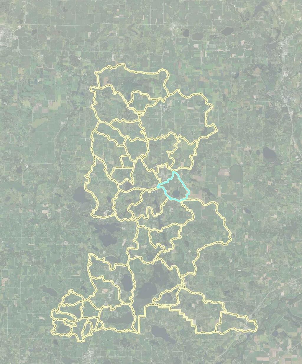
5 1.0 Project Location The project is replacement of an outlet on School Section Lake which is located in Stearns County north of the City of Kimball, Minnesota (T121N, R29W, S1 and S36, Figure 1.1). Figure 1.1: Project Location School Section Lake is a 193 acre land locked lake located in the Clearwater River Watershed District. The watershed tributary to the lake, 1,843 acres, is shown in Figure 1.2. June Rev August
6 Figure 1.2: School Section Lake Watershed June Rev August

7 2.0 Project Need DNR Records show that the 193 acre lake was landlocked up to 1,147 (datum not specified but USGS Quad maps are specified so it is likely NGVD 29) until the District constructed an outlet in 1984 as District Project #84-1. LiDAR indicates the outlet may be closer to 1,149 ft NGVD. Residents on the lake petitioned the District to install an outlet to alleviate high water levels on the lake. The peak lake level, 1,137.9 feet NGVD was measured in May of At that time, the DNR memo dated June 1, 1984 indicated 14 homes and cabins were destroyed or affected by the lake level and an additional 5 structures were at risk in 1984 due to the 1,137.9 lake elevation. Lake elevations are shown in Figures 2.1 and 2.2 (source, DNR Lake Finder). Since its installation, the outlet has maintained the lake below the OHW of 1, The DNR permitted elevation for the controlled outlet is 1, Figure 2.2 shows a finer scale of the past 10 years of lake elevations. During the past 10 years, the outlet generally discharges in the spring and summer. It is also important to note that according to the DNR, larger storms are becoming more frequent in Minnesota: Infographic: Timeline of Minnesota s Historic mega-rain events June Rev August
8 Lake Elevation (ft NGVD) Figure 2.1: Historic Lake Elevations 1,140 1,138 1,136 1,134 1,132 1,130 1,128 D-06 D-07 D-08 D-09 D-10 D-11 D-12 D-13 D-14 D-15 D-16 D-17 Date Lake Level 1984 Lake Level DNR OHW Figure 2.2: 10 year Record Lake Elevations The original outlet comprised a structure at the lake, a drop manhole, and hundreds of feet of 24-inch CMP, 36-inch CMP and open ditch. A schematic of the system is shown in Figure 2.3. The remainder of the original design plans are provided with the concept design in Appendix A. The original project cost in 1984 was $206,000. The 2017 value of $206,000 is $484,812. June Rev August
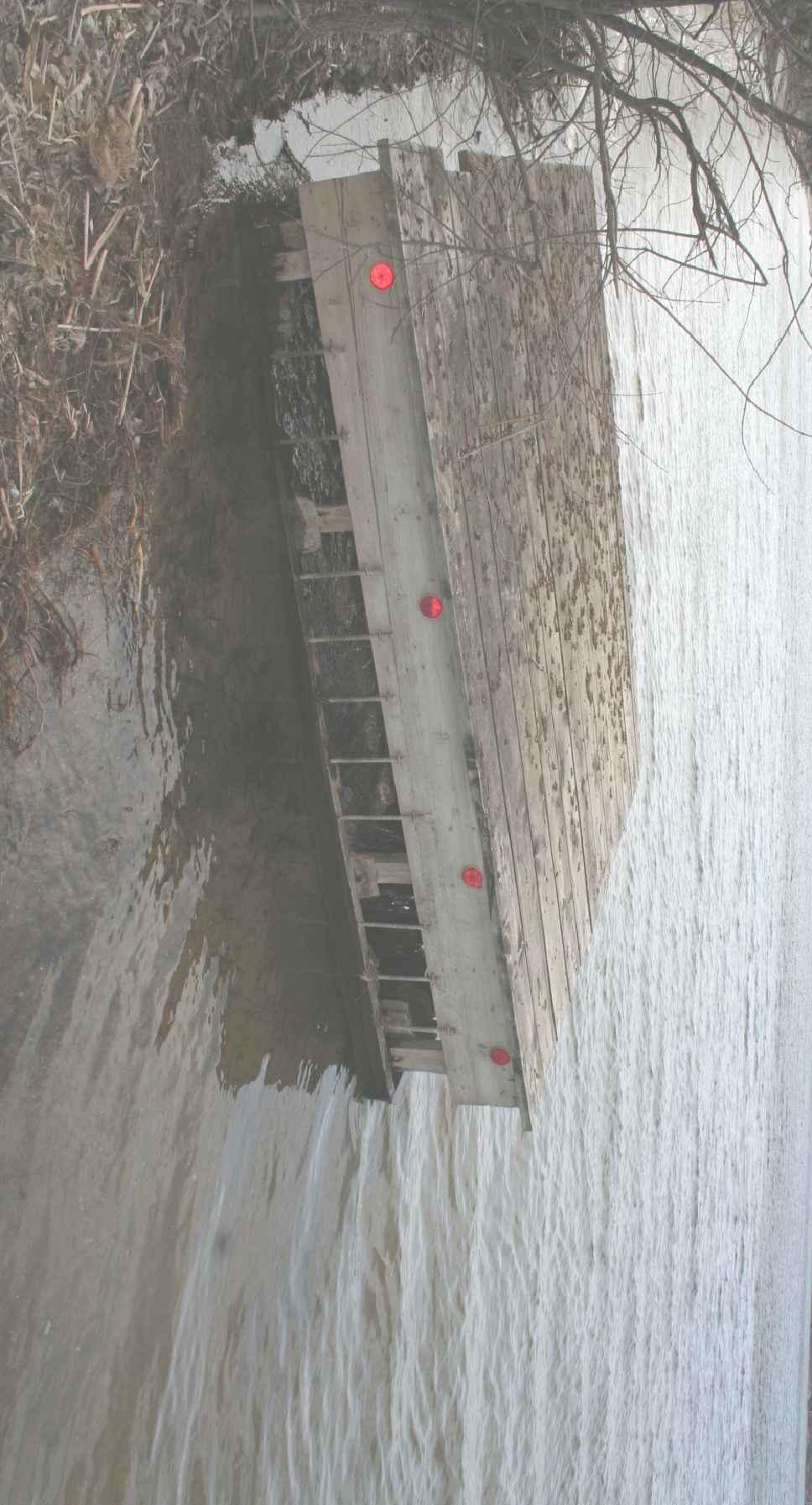
9 The conveyance downstream of the lake was sized to provide adequate outlet for the lake. As a District project, the outlet and its conveyance is inspected annually and maintained as needed. Currently, no maintenance is planned or needed. Figure 2.3: Original Outlet District staff reports show the outlet structure within the lake was repaired/maintained at least twice, and may have been repaired up to three additional times. Maintenance/ repairs occurred sometime in the late 1980 s or early 1990 s, 1997, 2007, 2011 and This is a recurrence of 2-5 times in 33 years. The repairs to the lake outlet are the result of a combination of ice damage, accumulated sediment in the conveyance, and wildlife building nests in the outlet. In addition to the ongoing cost of outlet repairs, obstruction of the outlet during a high water event poses the risk of damage to buildings due to flooding. The photo below shows the shoreline of School Section Lake near the outlet. The shoreline substrate is primarily rock and sand, and there is some evidence of heaving of the shoreline from ice. It appears as though ice has, from time to time, caused damage to the grate on the existing outlet as well as to the CMP. High water and wave action also has likely contributed to the erosion and characteristics along the shoreline in this location. June Rev August


10 School Section Lake Outlet- Lakeshore Photos Following the most recent repair, district staff installed I-beams in front of the outlet which were intended to shield the outlet from ice damage. This I-beam installation addressed the immediate need to maintain a functional outlet; the urgency at that time did not afford the District the ability to design the barrier as a long-term element of the outlet and did not June Rev August
11 incorporate the full range of design considerations such as those pertaining to safety and appearance. At its May 17, 2017 meeting, the District Board of Managers initiated Project #17-1 incorporating the existing Project #84-1 with construction of a permanent ice barrier and directed the Engineer to prepare a report pursuant to Minnesota Statutes 103D.711. Among other things, the engineer was directed to estimate the cost of a repair to the outlet and compare it to the ongoing cost of repairing the outlet and cleaning out accumulated sediment in the outlet. The proposed Project entails constructing a box weir around the CMP at the lake shore. However, the outlet within the lake is only one component of the entire Project which will include maintenance of the entire conveyance that comprises the outlet over the lifecycle of the proposed project. The relatively low cost of altering the outlet should be more cost effective and lower the risk of flooding due to accumulated sediment and ice damage. The Project will not increase flows from the lake and therefore does not raise a question as to an adequate downstream Project outlet since the original downstream conveyance was sized to accommodate the outflow. June Rev August
12 3.0 Alternatives Considered Three alternatives considered are described in this section. It is important to note that the DNR has indicated that if existing I-beam structure was damaged, a different structure or alternative will likely be required. 3.1 OPTION 1: DO NOTHING Leave the outlet as is with the I-beams to shield against ice damage. This alternative does not prevent sediment or wildlife from migrating into the pipe but may provide some protection from ice damage. This alternative was not selected due to ongoing maintenance and repair costs due to removal of sediment, the threat of flooding, and the fact that the installation was not designed as a long-term outlet design with full consideration of visual and safety elements. 3.2 OPTION 2: REMOVE I-BEAMS AND LEAVE OUTLET AS IS Remove the I-beams and leave the outlet as is otherwise. This alternative leaves the outlet subject to periodic ice damage and the potential to clog. There is no way to predict the return frequency of ice damage to the outlet. This alternative was not selected due to ongoing maintenance and repair costs related to ice damage and removal of sediment, and the threat of flooding. 3.3 OPTION 3: CONSTRUCT A COVERED WEIR BOX AROUND THE OUTLET Construct a sheet pile weir box tied back into the bank to protect the CMP. Set the elevation of the weir box to the DNR required outlet elevation of Because the weir is set at the outlet elevation, the weir box itself will prevent sediment migration. Rip rap at the bank and between the weir and the CMP will provide stilling and protect against sediment transport downstream and bank erosion. This alternative should afford greater protection against ice damage, as well as prevent sediment from migrating into the pipe. The proposed cover and grates have also been successful at excluding wildlife from the pipe. A similar outlet has been in operation at Pleasant Lake with positive results and low maintenance costs. The locking cap itself may not withstand ice heave, however the lake elevations are typically below the outlet elevation and so ice should act on the weir box, not the cap. In the event that the lake freezes at a high elevation, the locking cap may need to be replaced. June Rev August
13 4.0 Project Compatibility with State and Federal Law 4.1 WATERSHED DISTRICT AUTHORITY The Clearwater River Watershed Districts authority to take action on the implementation of this project is found in the Minnesota Watershed Act as taken from Minnesota Statues Chapter 103D CONTENT OF THE ENGINEER S REPORT This Engineer s Report is prepared in accordance with Minnesota Statute 103D.711 under the Minnesota Watershed Act. 4.3 CONFORMANCE WITH OVERALL PLAN The Clearwater River Watershed District requires projects undertaken under its jurisdiction to be consistent with the overall plan. This project is consistent with the overall plan as specifically addressed in Section 7, Policies. 4.4 OTHER REQUIREMENTS The Minnesota Department of Natural Resources will require a permit for work in public waters for this project. It has reviewed the preliminary design and identified regulatory concerns, which have been addressed by the recommended solution. June Rev August
14 5.0 Economic Consideration and Benefits 5.1 EXISTING AND ANTICIPATED BENEFITS Under 103D.721 managers may determine benefits and damages with the assistance of the engineer. This section is a compilation of information the managers may use to set benefits. The original School Section Lake project was constructed to alleviate flooding that occurred in 1984 and provide future flood protection for the residential lands and structures riparian to the lake. Fourteen to 19 structures were damaged or destroyed during the 1984 flood event. A portion of the original outlet was damaged. Replacing the damaged portion of the outlet and maintaining the conveyance are both required to provide School Section Lake an outlet. Both are necessary to reduce the risk of flooding to riparian land and structures. The proposed project, #17-1, includes two elements required to provide School Section Lake with an outlet. They are: Constructing a weir box around the upstream most component of the outlet to reduce the risk of sediment clogging the outlet and provide additional protection against ice damage Maintaining the remainder of the outlet conveyance which was constructed as part of Project #84-1. The proposed project should reduce maintenance costs and provide additional protection against ice heave and sediment migration downstream as well provide a cover for the outlet. In addition to reducing maintenance cost, reduction in sediment transport will protect habitat downstream by eliminating the potential for sediment transport and the need mitigate for it. 5.2 SUPPORT FOR DETERMINATION OF BENEFITS District staff, legal and managers have identified several elements the Board of Managers may use to set benefits. These include: 1. The cost to cure a potential flood event like the one which occurred in 1984 prompting construction of the outlet. The engineer has quantified this by using the taxable value of the riparian structures potentially damaged based on LIDAR elevation. 2. A temporary reduction in land value due to an acute flooding event. Limited data exists as to the impact of temporary flooding on property values. A literature review suggested a range of possible reductions in property values. The engineer quantified what the low end of the reduction in property values reported would be on the taxable value of structures and land for riparian homes. 3. Reduction in maintenance costs due to the project. The resulting values are summarized in Table 5.1, and described in the following sections for use by the managers to establish benefits. June Rev August
15 Table 5.1: Summary of Engineer s Assistance for Board Use in Determining Benefits Description Estimate Flood damaged structures $1,348,400 15% reduction in property values $1,421,895 Reduction in maintenance cost over 50 $53,300 year lifecycle of weir outlet Flood Damage: Properties riparian to a land locked lake with no natural outlet are at risk of flooding. Prior to installation of the original project in 1984, between 14 and 19 homes were damaged or destroyed by high spring water levels. Ice damage and sediment migration into the outlet structure on the lake have reduced the outlet capacity periodically and required repairs in the past. To date repairs have been made prior to lake levels rising enough to cause damage, however an outlet structure susceptible to early season failure could cause flood elevations that damage riparian homes and property. The taxable value of potentially flooded structures in a singular event similar to the flood of 1984 was used to quantify a portion of the benefits of flood protection. This is a conservative estimate. It does not account for temporary loss of property use, property damage, potential loss of riparian land by erosion or avulsion, reduced property use due to expanded floodplain or setback, or a potential expansion of federal flood insurance requirements. It also does not take into account the potential for multiple flooding events over a period of time Reduction in Property Values: Resale value for properties recently flooded is between 15 and 60% lower than for similar properties in areas not flooded, according to this study: Eves, C., & Wilkinson, S. (2013). Assessing the immediate and short-term impact of flooding on residential property participant behavior. Natural Hazards, 71(3), doi: /s y The total reduction in property value due to the absence of a reliable outlet was quantified using a conservative 15% reduction in the taxable market value of riparian properties based on the study listed above. As noted, this study documented short- and intermediate-term reductions in property values that varied from 15 to 60% Avoided Repairs: The outlet has been repaired two to five times as the result of ice heave damage and subsequent sediment migration into the pipe. Avoided repair costs for these damages assuming a 50 year lifespan for the proposed weir outlet are $13,325 each repair, and $53,300 assuming 4 repairs. This estimate is calculated in present costs for comparison with present benefits. June Rev August
16 Table 5.2: Maintenance Costs Avoided DESCRIPTION UNIT QTY UNIT COST COST 1 MOBILIZATION LS 1 $2,500 $2,500 2 CLEAR & GRUB LS 1 $2,500 $2,500 3 JET & VAC LINE LS 1 $2,500 $2,500 4 REMOVE AND REPLACE CMP LF 10 $100 $1,000 5 SITE RESTORATION LS 1 $500 $500 6 FLOATING SILT CURTAIN LIN FT 100 $30 $3,000 7 SILT FENCE, TYPE MACHINE SLICED - MAINTAINED LIN FT 150 $4 $525 8 TEMPORARY CONSTRUCTION ENTRANCE EACH 1 $800 $800 TOTAL $13,325 EST REPAIR FREQUENCY IN 50 YEARS EACH 4 $13,325 $53, ESTIMATED PROJECT COSTS The cost for the original project constructed in 1984 was $206,000. The 2017 value of $206,000 is $484,812. This is the value that will be used to set the maintenance fund. In accordance with Minnesota Statutes 103D.711, project cost is a combination of land acquisition, construction, supervision, administrative and operational costs for the outlet and conveyance that constitute the Project. The total project cost over its 50 year lifecycle is estimated as follows: Table 5.3: Estimated Project Costs Description Cost Construction $101,293 Operation $336,527 Total: $448,113 These costs are itemized in the sections below. June Rev August
17 5.3.1 Construction Costs: The project schematic design is included in Appendix A. Estimated project costs for construction, engineering, permitting, legal, and administration are included in Table 5.4. Table 5.4: Estimated Project Costs Construction, Engineering, Permitting, Legal and Administration No. Item Units Qty Unit Cost Estimate 1 MOBILIZATION LS 1 $2,500 $2,500 2 TREE CLEARING FOR SITE ACCESS LS 1 $5,000 $5,000 SALVAGE AND REINSTALL RIP 3 RAP ON SITE LS 1 $1,000 $1,000 4 REMOVE I BEAMS LS 1 $1,000 $1,000 5 FURNISH & INSTALL OUTLET PLATFORM (WOOD) LS 1 $2,500 $2,500 6 EXCAVATE OUTLET LS 1 $500 $500 7 FURNISH & INSTALL CAPPED SHEET PILE WEIR (4' x 8' x 8' - 10' depth) SQ. FT. 200 $50 $10,000 8 SHEET PILE BEND EACH 4 $1,000 $4,000 9 REPLACE 24" CMP LF 100 $120 $12, CONNECTION TO OUTLET PIPE EACH 1 $1,000 $1, CLASS 3 RIP RAP- FURNISH & INSTALL CY 7 $110 $ REMOVE EXISTING WEIR IN MANHOLE LS 1 $1,000 $1, SITE RESTORATION LS 1 $1,000 $1, FLOATING SILT CURTAIN LIN FT 100 $30 $3,000 SILT FENCE, TYPE MACHINE 15 SLICED - MAINTAINED LIN FT 150 $4 $ PROJECT SIGNAGE LS 1 $1,500 $1, TEMPORARY CONSTRUCTION ENTRANCE EACH 1 $1,500 $1,500 SUBTOTAL $48,795 20% CONTINGENCY $9,759 Engineers Estimate of Probable Cost: $58,554 Engineering, Legal & Administrative $14,639 Estimated Expenses to Date: $28,100 Total Estimated Expense: $101,293 June Rev August
18 5.3.2 Operation Costs: No. Item Units Qty Unit Cost Estimate 1 MOBILIZATION LS 7 $2,500 $17,500 2 TREE CLEARING FOR SITE ACCESS LS 7 $2,000 $14,000 3 REMOVE & REPLACE 24" CMP LF 620 $120 $74,400 4 REMOVE & REPLACE 36" CMP LF 190 $145 $27, CLEAN OUT OPEN DITCH (assumes 2 cleanouts in 50 yrs) REMOVE & REPLACE DROP MANHOLE LF 1330 $8 $10,640 LS 1 $6,000 $6,000 7 POND CLEANOUTS EACH 4 $12,000 $48,000 8 REMOVE AND REPLACE OUTLET CAP EACH 2 $3,000 $6,000 9 SITE RESTORATION LF 100 $120 $12, CONNECTION TO OUTLET PIPE EACH 1 $1,000 $1, CLASS 3 RIP RAP- FURNISH & INSTALL REMOVE EXISTING WEIR IN MANHOLE CY 7 $110 $770 LS 1 $1,000 $1, SITE RESTORATION LS 7 $1,000 $7, FLOATING SILT CURTAIN LIN FT 300 $30 $9, TEMPORARY CONSTRUCTION ENTRANCE EACH 6 $1,500 $9,000 SUBTOTAL $243,860 20% CONTINGENCY $48,772 Engineers Estimate of Probable Cost: $292,632 Engineering, Legal & Administrative $43,895 Total Estimated Expense: $336,527 June Rev August

19 Figure 5.1: School Section Lake Watershed Parcel June Rev August
20 6.0 Easements, Right-of-Way, Property Ownership Easements acquired during construction of the original project will be sufficient to support this Project. The board may choose to update existing easements to current standards. June Rev August
21 7.0 Environmental Assessment The project will reduce downstream migration of sediment from the lake to other areas of the outlet and therefore will have a positive habitat benefit. Further, installation of an outlet that requires less maintenance mean less disturbance of lake shore habitat and less possibility for erosion associated with maintenance activities. Management of lake elevation will promote the stability of the riparian edge of School Section Lake. June Rev August
22 8.0 Funding The project and any subsequent maintenance will be funded by assessing benefited property owners. The District Board of Managers will determine the allocation of the assessment. Riparian properties are listed in Appendix B. June Rev August
23 9.0 Findings The engineer finds that construction of a sheet pile wire with wood platform and grates around the existing CMP outlet and operation of the remainder of the conveyance is feasible. June Rev August
24 Proposal Site Plan Appendix A

25 SHEET INDEX

26

27
28
29 Benefited Parcels Appendix B
30 Benefited Parcels TAXPARCEL EMV LAND EMV BUILDING TOTAL EMV $ 134,700 $ - $ 134, $ 73,900 $ 1,500 $ 75, $ 74,000 $ 199,400 $ 273, $ 71,500 $ - $ 71, $ 75,400 $ 125,900 $ 201, $ 113,500 $ - $ 113, $ 76,800 $ 100,700 $ 177, $ 91,200 $ 56,800 $ 148, $ 30,500 $ - $ 30, $ 146,600 $ 122,800 $ 269, $ 98,200 $ 15,500 $ 113, $ 206,900 $ 10,900 $ 217, $ 106,200 $ - $ 106, $ 114,700 $ 106,600 $ 221, $ 72,500 $ 118,600 $ 191, $ 79,900 $ - $ 79, $ 75,400 $ 119,000 $ 194, $ 44,700 $ - $ 44, $ 82,900 $ 117,000 $ 199, $ 50,700 $ - $ 50, $ 43,400 $ 55,000 $ 98, $ 44,900 $ 66,000 $ 110, $ 115,200 $ - $ 115, $ 134,400 $ 139,900 $ 274, $ 11,500 $ 3,200 $ 14, $ 56,200 $ 152,800 $ 209, $ 17,200 $ - $ 17, $ 125,400 $ - $ 125, $ 116,900 $ 251,000 $ 367, $ 112,600 $ - $ 112, $ 118,200 $ 25,200 $ 143, $ 144,800 $ 101,900 $ 246, $ 129,100 $ 182,900 $ 312, $ 79,100 $ 37,600 $ 116, $ 57,400 $ 68,900 $ 126, $ 87,100 $ 193,800 $ 280, $ 56,300 $ 171,100 $ 227, $ 33,900 $ - $ 33, $ 15,000 $ - $ 15, $ 24,700 $ - $ 24, $ 115,400 $ 290,200 $ 405, $ 76,800 $ 183,300 $ 260, $ 21,300 $ - $ 21, $ 73,500 $ 57,000 $ 130, $ 29,500 $ - $ 29, $ 30,600 $ - $ 30, $ 32,600 $ - $ 32, $ 162,300 $ 8,100 $ 170, $ 123,100 $ 144,200 $ 267, $ 33,500 $ - $ 33, $ 52,000 $ 31,200 $ 83, $ 130,800 $ - $ 130, $ 116,200 $ 186,600 $ 302, $ 116,800 $ - $ 116, $ 487,400 $ - $ 487, $ 86,100 $ - $ 86, $ 887,500 $ 115,800 $ 1,003,300
31 Toll Free: Web: wenck.com
Opinion of Probable Cost
 Appendix E Opinion of Probable Cost 01054/8410233/14/Rohner_Alt_Analysis_Report Rohner Creek Flood Control, Habitat and Seismic Improvement Project Alternatives Analysis Cost Alternative 1: Improved Channel
SUTTER BUTTER FLOOD CONTROL AGENCY FEATHER RIVER WEST LEVEE PROJECT PROJECT C, CONTRACT NO C BID TABULATION
 Bid Schedule A - Feather River West Levee Project C Improvements No. Item Description Quantity Unit Nordic/Magnus Pacific JV Engineer's Estimate Unit Price Total Price Unit Price Total Price A1 Injury
STORMWATER MANAGEMENT FUND Department of Environmental Services
 Department of Environmental Services Mission: To implement a comprehensive stormwater management program that balances the following goals: 1) to reduce the potential for stormwater threats to public health,
FREQUENTLY ASKED QUESTION ABOUT FLOODPLAINS Michigan Department of Environmental Quality
 FREQUENTLY ASKED QUESTION ABOUT FLOODPLAINS Michigan Department of Environmental Quality WHAT IS A FLOOD? The National Flood Insurance Program defines a flood as a general and temporary condition of partial
33 Ditch Bottom Inlet (DBI) -Type E $ 2, EA - 0 $ - 35 Ditch Bottom Inlet (DBI) -Type H (Modified) $ 5, EA $ 5,600.
 -Type E $ 2, EA - 0 $ - 35 Ditch Bottom Inlet (DBI) -Type H (Modified) $ 5, EA $ 5,600.") CITY OF PLANT CITY WHEELER STREET RE-ALIGNMENT Opinion of Probable Construction Costs (Final Plans) Rev 7/22/2010 Rev 8/2/2010 Rev 8/27/20012 Bid Cost per Estimated Extended Item Item Unit Units Wheeler
CITY OF PLANT CITY WHEELER STREET RE-ALIGNMENT Opinion of Probable Construction Costs (Final Plans) Rev 7/22/2010 Rev 8/2/2010 Rev 8/27/20012 Bid Cost per Estimated Extended Item Item Unit Units Wheeler
City of Centerville BMP Pages Table of Contents. Minimum Control Measure 1. Public Education and Outreach
 i City of Centerville s Table of Contents Minimum Control Measure 1. Public Education and Outreach Best Management Practice Page 1-1: Outreach Publications...1 1-2: 30-day Public Notice for Annual Storm
Rock Chalk Park - Infrastructure Report. July 2013
 Rock Chalk Park Infrastructure Report July 2013 The following report is the first monthly report for the construction of infrastructure at Rock Chalk Park. The format follows the sections outlined in the
Attachment B. King County Flood Control Zone District Work Program
 Attachment B King County Flood Control Zone District Work Program The King County Flood Control Zone District work program is comprised of two major categories: Programmatic Work Program o Flood Preparedness,
SUBDIVISION IMPROVEMENTS AGREEMENT
 SUBDIVISION IMPROVEMENTS AGREEMENT THIS AGREEMENT, made between GLEN DEVELOPMENT COMPANY, hereinafter called the "Subdivider," and El Paso County by and through the Board of County Commissioners of El
DEPARTMENT OF THE ARMY OFFICE OF THE CHIEF OF ENGINEERS WASHINGTON, D.C
 .t DEPARTMENT OF THE ARMY OFFICE OF THE CHIEF OF ENGINEERS WASHINGTON, D.C. 20314-1000 REPLY TO A TTENTION OF: CECW-PE (l0-1-7a) 1 3 OCT 199B SUBJECT: Tampa Harbor, Big Bend Channel, Florida THE SECRETARY
FLOODPLAIN DEVELOPMENT VARIANCE APPLICATION PACKET
 FLOODPLAIN DEVELOPMENT VARIANCE APPLICATION PACKET Sutter County Water Resources Department 1130 Civic Center Boulevard Yuba City, California, 95993 (530) 822-7400 Floodplain management regulations cannot
2015 Financial Assurance 8/6/2015 Estimate Form (with pre-plat construction)
") 2015 Financial Assurance 8/6/2015 Estimate Form (with pre-plat construction) Project Information The Glen at Widefield Filing No. 9 PDD File: SF-185 9/25/2018 Project Name Section 1 - Grading and Erosion
2015 Financial Assurance 8/6/2015 Estimate Form (with pre-plat construction) Project Information The Glen at Widefield Filing No. 9 PDD File: SF-185 9/25/2018 Project Name Section 1 - Grading and Erosion
Content Copy Of Original
 Content Copy Of Original Ministry of the Environment and Climate Change Ministère de l Environnement et de l Action en matière de changement climatique Greystone Village Inc. 1737 Woodward Drive, Unit.
Request for Proposals. Silver Cliff Ranch-Forest Stand Improvement
 CONTRACTOR BID AND REQUEST FOR PROPOSALS---Request for Bids and Contractor Bid incorporated by reference. Work scope is as outlined in the Request for Bids and per instruction of ARWC project manager.
TOTAL QUANTITY UNIT COST UNIT
 BASE BID DIVISION 1 - GENERAL 1 1070-206-A-0 TRAFFIC CONTROL LS 1 $ 10,000 $ 10,000 $3,000.00 $3,000.00 $5,600.00 $5,600.00 2 2010-108-B-0 CLEARING AND GRUBBING AC 5 $ 9,000 $ 45,000 $7,192.50 $35,962.50
City of Kinston. Stormwater Utility Credit Manual
 City of Kinston Stormwater Utility Credit Manual Effective Date: July 1, 2008 Table of Contents 1.0 INTRODUCTION...3 2.0 DEFINITIONS...4 3.0 GENERAL CREDIT POLICIES...4 4.0 STORMWATER BMP CREDIT POLICY.......................
Crediting Adaptation Strategies through the National Flood Insurance Program s Community Rating System Coordinator s Manual
 Crediting Adaptation Strategies through the National Flood Insurance Program s Community Rating System Coordinator s Manual W. Thomas Hawkins, Adjunct Faculty, University of Florida, Levin College of Law
CRISP COUNTY, GEORGIA AND INCORPORATED AREAS
 CRISP COUNTY, GEORGIA AND INCORPORATED AREAS Community Name Community Number ARABI, CITY OF 130514 CORDELE, CITY OF 130214 CRISP COUNTY (UNINCORPORATED AREAS) 130504 Crisp County EFFECTIVE: SEPTEMBER 25,
JANUARY 13, ILL. ADM. CODE CH. I, SEC TITLE 17: CONSERVATION CHAPTER I: DEPARTMENT OF NATURAL RESOURCES SUBCHAPTER h: WATER RESOURCES
 TITLE 17: CONSERVATION CHAPTER I: DEPARTMENT OF NATURAL RESOURCES SUBCHAPTER h: WATER RESOURCES PART 3702 CONSTRUCTION AND MAINTENANCE OF DAMS Section Page No. 3702.10 Purpose 2 3702.20 Definitions 3 3702.30
STORMWATER MANAGEMENT FUND DEPARTMENT OF ENVIRONMENTAL SERVICES
 DEPARTMENT OF ENVIRONMENTAL SERVICES Mission: To implement a comprehensive stormwater management program that balances the following goals: 1) to reduce the potential for stormwater threats to public health,
TOWN OF KENT, CT PLANNING AND ZONING COMMISSION
 TOWN OF KENT, CT PLANNING AND ZONING COMMISSION FLOOD PLAIN MANAGEMENT REGULATIONS Whereas, Congress has determined that a National Flood Insurance Program would alleviate personal hardships and economic
PERMIT Under the Environmental Conservation Law (ECL)
") PERMIT Under the Environmental Conservation Law (ECL) EMERGENCY GENERAL PERMIT GP-0-17-006 Lake Ontario Erosion Control Permittee and Facility Information Permit Issued To: Applicant shown on Application/Authorization
PERMIT Under the Environmental Conservation Law (ECL) EMERGENCY GENERAL PERMIT GP-0-17-006 Lake Ontario Erosion Control Permittee and Facility Information Permit Issued To: Applicant shown on Application/Authorization
No An act relating to regulation of flood hazard areas, river corridors, and stream alteration. (S.202)
") No. 138. An act relating to regulation of flood hazard areas, river corridors, and stream alteration. (S.202) It is hereby enacted by the General Assembly of the State of Vermont: Sec. 1. 10 V.S.A. chapter
No. 138. An act relating to regulation of flood hazard areas, river corridors, and stream alteration. (S.202) It is hereby enacted by the General Assembly of the State of Vermont: Sec. 1. 10 V.S.A. chapter
Chicopee River CSO Project Springfield Water & Sewer Commission. APWA Congress September 9, CSO Control Plan. CSO Control
 Chicopee River CSO Project Springfield Water & Sewer Commission APWA Congress September 9, 2007 CSO Control Plan Typical Approach Different Thinking on Controlling Costs Case Example Springfield MA CSO
Village Glen HOA P.O. Box 1537, Arroyo Grande, CA. Reserve Study
 Village Glen HOA P.O. Box 1537, Arroyo Grande, CA Reserve Study As required by the state of California, it is the responsibility of the Board of Directors to create and maintain adequate reserves to provide
Bucks County, PA Flood Risk Review Meeting. November 2014
 Bucks County, PA Flood Risk Review Meeting November 2014 Agenda for Today Risk MAP Program overview Overview of non-regulatory Flood Risk Products and datasets Discuss mitigation action Technical overview
TITLE: Authorization to Award Contract for Construction and Construction Oversight Contract for the Powell Road Stormwater Diversion Project
 Minnehaha Creek Watershed District REQUEST FOR BOARD ACTION MEETING DATE: March 26, 2015 TITLE: Authorization to Award Contract for Construction and Construction Oversight Contract for the Powell Road
6.0 MONITORING AND CONTINGENCY PLANS
 6.0 MONITORING AND CONTINGENCY PLANS 6.1 MONITORING The primary objective of compliance and effects monitoring is to confirm whether mitigation and protective measures are effectively implemented and to
***EXPEDITED REVIEW***
 ***EXPEDITED REVIEW*** Application for Erosion and Sediment Pollution Control Plan Adequacy Review General NPDES Plan Review This application must be completed and accompanied by the required fees, plans,
Stormwater Management Utility Fee Reduction Credit Application
 Stormwater Management Utility City of Dubuque, IA Winter 2003 Stormwater Management Utility Stormwater Management Utility Introduction The City of Dubuque established a Stormwater Management Utility on
FINAL TECHNICAL MEMORANDUM AWD FLOWS THROUGH FLOOD DAMAGE REDUCTION AREA July 16, 2012
 FINAL TECHNICAL MEMORANDUM AWD-00002 FLOWS THROUGH FLOOD DAMAGE REDUCTION AREA July 16, 2012 Table of Contents TABLE OF CONTENTS Table of Contents... 1 Executive Summary... 2 1 Objective... 4 2 Study Approach...
Chapter 6 - Floodplains
 Chapter 6 - Floodplains 6.1 Overview The goal of floodplain management is to reduce the potential risks to both existing and future developments, and infrastructure, in the 100-year floodplain. Over the
Changes in Criteria and Scoring for CRS Outreach Projects
 Changes in Criteria and Scoring for CRS Outreach Projects A Handout for the National Flood Insurance Program Community Rating System Many communities want to keep disseminating and obtaining CRS credit
FINAL INTEGRATED GENERAL REEVALUATION REPORT AND SUPPLEMENTAL ENVIRONMENTAL IMPACT STATEMENT ADDENDUM
 FINAL INTEGRATED GENERAL REEVALUATION REPORT AND SUPPLEMENTAL ENVIRONMENTAL IMPACT STATEMENT BREVARD COUNTY, FLORIDA HURRICANE AND STORM DAMAGE REDUCTION PROJECT MARCH 2014 U.S. Army Corps of Engineers
Public Notice. Proposed anchor structures, dredging, and discharge at the Enbridge Line 5 pipeline in the Straits of Mackinac, Michigan
 US Army Corps of Engineers Detroit District Public Notice Applicant: Enbridge Pipelines (Lakehead), LLC In Reply Refer To: Corps File No. LRE-2010-00463-56-N18 Date: January 29, 2019 Expires: February
Action Items for Flood Risk Management on Wildcat Creek Interagency success with floodplain management plans and flood forecast inundation maps
 Presentation to USACE 2012 Flood Risk Management and Silver Jackets Joint Workshop, Harrisburg, Pennsylvania Action Items for Flood Risk Management on Wildcat Creek Interagency success with floodplain
Thurston County, WA Flood Hazard Mitigation Plan Annual Progress Report CRS Activity 510
 Thurston County, WA Flood Hazard Mitigation Plan Annual Progress Report CRS Activity 510 Reporting Period: ctober 1, 2014 to September 30, 2015 Background: Thurston County developed a flood hazard mitigation
Electric Service Information Sheet Georgia Power Company
 Electric Service Information Sheet Georgia Power Company Project: Location: Developer: (Name of S/D or Customer) (Street Address or road Name) (Developer s Name) Georgia Power Company (the Company) will
Update of Project Benefits
 Update of Project Benefits February 2014 Contents 1. Introduction 1 2. Purpose of the Revaluation Study 2 3. Original Project Benefits 2 4. Update of Residential Structure Benefits 3 5. Update of Non Residential
CHAGRIN RIVER WATERSHED PARTNERS, INC. Lower Main Branch and East Branch Streambank Stabilization and Grassed Filter Strip Project
 CHAGRIN RIVER WATERSHED PARTNERS, INC. Lower Main Branch and East Branch Streambank Stabilization and Grassed Filter Strip Project REQUEST FOR PROPOSALS August 4, 2014 SECTION A: SUPPLIES OR SERVICES AND
SUBJECT: Flagler County, Florida, Hurricane and Storm Damage Reduction Project
 DEPARTMENT OF THE ARMY CHIEF OF ENGINEERS 2600 ARMY PENTAGON WASHINGTON, DC 20310-2600 REPLY TO ATTENTION OF DAEN B3 DEC 2014 THE SECRETARY OF THE ARMY 1. I submit for transmission to Congress my report
Barnes County Water Resource District
 Barnes County Water Resource District PO Box 306 Valley City, ND 58072 701-845-8508 April 14, 2014 MEETING MINUTES PRESENT MEMBERS: Chairperson Jerry Hieb; Manager Ken Evenson; Manager Bruce Anderson;
CONTINUING AUTHORITIES PROJECT (CAP) Federal Interest Determination
 Federal Interest Determination") Date: 8 May 2013 Division: Great Lakes and Ohio River Division District: Nashville District CONTINUING AUTHORITIES PROJECT (CAP) Federal Interest Determination 1. Project: Cumberland River, Metropolitan
Date: 8 May 2013 Division: Great Lakes and Ohio River Division District: Nashville District CONTINUING AUTHORITIES PROJECT (CAP) Federal Interest Determination 1. Project: Cumberland River, Metropolitan
BID PROPOSAL. PROPOSAL OF, a corporation, a partnership consisting of. an individual doing business as
 Description 103 REMOVE, STORE AND REINSTALL EXISTING RETAINING WALL 107.1 EMBANKMENT (FINAL)(DENS CONT)(TY B) 203.1 TACK COAT BID PROPOSAL PROPOSAL OF, a corporation, a partnership consisting of an individual
King County Flood Control District 2015 Work Program
 Attachment A 2015 Work Plan 10-24-14 King County Flood Control District 2015 Work Program The District work program is comprised of three categories: district oversight and policy development, operations,
BOCA RATON INLET MANAGEMENT STUDY IMPLEMENTATION PLAN CERTIFICATE OF ADOPTION
 BOCA RATON INLET MANAGEMENT STUDY IMPLEMENTATION PLAN CERTIFICATE OF ADOPTION WHEREAS the Department of Environmental Protection, in partnership with the City of Boca Raton. has sponsored a study of the
2011 MT Floods Damages and Recovery Options
 MONTANA 2011 MT Floods Damages and Recovery Options Damage Estimates Public Works: Between $57.5 million Individual: id Housing Assistance $4,442,194 Small Business Assistance $1,634,100 Other Needs
FURTHER TO EXECUTIVE COMMITTEE MEETING #13/11 To be held on Friday, February 3, 2012
 FURTHER TO EXECUTIVE COMMITTEE MEETING #13/11 To be held on Friday, February 3, 2012 FURTHER TO: Pages EX6. CORRESPONDENCE EX6.1 A letter dated January 11, 2012 from Mr. David de Launay, Assistant Deputy
Section 1. Status of Restoration Compliance Report
 Section 1 Status of Restoration Compliance Report Chapter 1 Status of Restoration Compliance Report Compliance with State Water Resources Control Board Decision 1631 and Order Nos. 98-05 and 98-07 May
Failure to acknowledge all addenda in the BID may cause rejection of the BID. See Instructions to Bidders.
 Addendum #1 409 22nd Ave So PO Box 298 Brookings, SD 57006 Toll Free 1-855-323-6342 www.bannerassociates.com Project: Viborg Utility Improvements - 2017 Bid Date: 11:00 A.M., Local Time, March 15, 2017
GEAUGA PARK DISTRICT Bessie Benner Metzenbaum Park Restoration Request for Proposals (Design-Build Services) February 15, Geauga Park District
 February 15, Geauga Park District") GEAUGA PARK DISTRICT Bessie Benner Metzenbaum Park Restoration Request for Proposals (Design-Build Services) February 15, 2018 Geauga Park District Board of Park Commissioners Andrej Lah, President Jackie
GEAUGA PARK DISTRICT Bessie Benner Metzenbaum Park Restoration Request for Proposals (Design-Build Services) February 15, 2018 Geauga Park District Board of Park Commissioners Andrej Lah, President Jackie
Lake County Stormwater Utility Fee
 County of Lake Stormwater Management Department 550 Blackbrook Road Painesville, OH 44077 Phone: (440) 350-2770 Fax: (440) 352-8133 www.lakecountyohio.org/smd Lake County Stormwater Utility Fee Credit
CATFISH CREEK CONSERVATION AUTHORITY. Financial Statements. December 31, 2009
 CATFISH CREEK CONSERVATION AUTHORITY Financial Statements December 31, 2009 Financial Statements Table of Contents PAGE Auditors' Report 1 Statement of Financial Position 2 Statement of Reserves 3 Statement
GENERAL PLAN AMENDMENT # FLOOD HAZARDS
 GENERAL PLAN AMENDMENT #2011-03 FLOOD HAZARDS The following text that appears on pages HS 3-4 of the Health and Safety Element in the Yolo 2030 Countywide General Plan has been amended. New language is
University Drive Flood Risk Management Project Phase I 58 th Ave S to 500 S of 64 th Ave S City of Fargo Project FM-15-C1
 University Drive Flood Risk Management Project Phase I 58 th Ave S to 500 S of 64 th Ave S City of Fargo Project FM-15-C1 Public Informational Meeting October 15, 2015 6:00 P.M. Overview Flood Risk FEMA
AVERAGE OF BID ITEMS ENGINEERS ESTIMATE
 ROADWAY 1 Mobilization 1 LS $ 990,048.50 $ 80,000.00 $ 880,000.00 $ 880,000.00 $ 950,000.00 $ 950,000.00 $ 967,510.00 $ 967,510.00 $ 1,162,684.00 $ 1,162,684.00 2 Maintenance of Traffic ( incl. Pedestrian
STORMWATER MANAGEMENT FUND DEPARTMENT OF ENVIRONMENTAL SERVICES
 DEPARTMENT OF ENVIRONMENTAL SERVICES Mission: To implement a comprehensive stormwater management program that balances the following goals: 1) to reduce the potential for stormwater threats to public health,
Water Resources Engineering Division Public Works City of Colorado Springs
 Water Resources Engineering Division Public Works City of Colorado Springs Richard Mulledy, P.E. Division Manager City of Colorado Springs/Pueblo County IGA City of Colorado Springs/Pueblo County IGA $460
Cumberland County, NJ. Risk MAP Project Status Update April 22, 2013
 Cumberland County, NJ Risk MAP Project Status Update April 22, 2013 Agenda Project Team Milestones Risk MAP Overview Study Scope overview Regulatory products Non-regulatory products Proposed Schedule Risk
Town of Middleton Salt Storage Building Pioneer Road Pioneer Lands Town of Middleton Dane County, WI 53562
 Town of Middleton Salt Storage Building Pioneer Road Pioneer Lands Town of Middleton Dane County, WI 53562 1 T100 PROJECT LOCATION MAP Scale: NTS N Revisions: No. Date: Description: Scale As Indicated
MINUTES OF REGULAR MEETING OF THE COMFORT LAKE - FOREST LAKE WATERSHED DISTRICT THURSDAY, JULY 23, 2009
 MINUTES OF REGULAR MEETING OF THE COMFORT LAKE - FOREST LAKE WATERSHED DISTRICT THURSDAY, JULY 23, 2009 1) Call to Order The President called the July 23, 2009 regular Board meeting to order at 6:30 p.m.
City of Madison 2018 Capital Improvement Plan Agency Request Summary
 City of Madison 2018 Capital Improvement Plan Agency Request Summary Agency : Agency Request by Project (All Funds) Project 2230 Broadway ## Citywide Flood Mitigation 350,000 875,000 550,000 575,000 675,000
CHAPTER 15: FLOODPLAIN OVERLAY DISTRICT "FP"
 CHAPTER 15: FLOODPLAIN OVERLAY DISTRICT "FP" SECTION 15.1 STATUTORY AUTHORIZATION The legislature of the State of Minnesota in Minnesota Statutes, Chapter 103F and Chapter 394 has delegated the responsibility
EAGAN-INVER GROVE HEIGHTS WATERSHED MANAGEMENT ORGANIZATION
 EAGAN-INVER GROVE HEIGHTS WATERSHED MANAGEMENT ORGANIZATION AGENDA BOARD OF MANAGERS MEETING EAGAN MUNICIPAL CENTER BUILDING March 17, 2015 5:30 P.M. I. Call to Order II. III. IV. Approval of Agenda Consent
Floodplain Development Permits A Technical Guidance Document
 Floodplain Development Permits A Technical Guidance Document To Prevent Loss of Life, Reduce Property Damage and to Protect and Enhance the Natural and Beneficial Functions of Floodplains Iredell County
CHAPTER 4. REGULATIONS AND DEVELOPMENT STANDARDS
 CHAPTER 4. REGULATIONS AND DEVELOPMENT STANDARDS Regulations and development standards, which can be used by communities to reduce damage from natural hazards, work best when using an effective planning
Job No Medina River Sewer Outfall, Segment 5 Solicitation No. B BB BID PROPOSAL
 Solicitation No. B-11-030-BB Date: BID PROPOSAL PROPOSAL OF A corporation A partnership consisting of An individual doing business as THE SAN ANTONIO WATER SYSTEM Pursuant to Instructions and Invitations
REQUEST FOR PROPOSAL Engineering Survey/Design Services Loecy Pond Dam Modification or Rehabilitation August 27, 2018
 REQUEST FOR PROPOSAL Engineering Survey/Design Services Loecy Pond Dam Modification or Rehabilitation August 27, 2018 I. INTRODUCTION Chagrin River Watershed Partners, Inc. (CRWP), located at 38238 Glenn
The following documentation is an electronicallysubmitted vendor response to an advertised solicitation from the West Virginia Purchasing Bulletin
 The following documentation is an electronicallysubmitted vendor response to an advertised solicitation from the West Virginia Purchasing Bulletin within the Vendor Self Service portal at wvoasis.gov.
CITY OF NEWCASTLE COUNCIL MEETING CITY HALL COUNCIL CHAMBERS NEWCASTLE WAY, SUITE 200 DECEMBER 18, CALL TO ORDER
 CITY OF NEWCASTLE COUNCIL MEETING CITY HALL COUNCIL CHAMBERS 12835 NEWCASTLE WAY, SUITE 200 DECEMBER 18, 2012 SPECIAL MEETING 12:00 P.M. 1. CALL TO ORDER 2. GENERAL BUSINESS a. AB 12 077 Resolution Authorizing
Public Meeting Impact of Hurricane Irma on Central Beach
 Public Meeting Impact of Hurricane Irma on Central Beach CITY OF NEW SMYRNA BEACH October 11, 2017 at 6:00 pm Presentation Outline Hurricane Irma Impacts Flooding Caused by Hurricane Irma Original Goals
Mill Creek Floodplain Proposed Bylaw Frequently Asked Questions
 Mill Creek Floodplain Proposed Bylaw Frequently Asked Questions Q: What is a Floodplain Bylaw? A: A Floodplain Bylaw is a flood hazard management tool to ensure future land use will be planned and buildings
FEASIBILITY REPORT 2012 IMPROVEMENT PROGRAM INVER GROVE HEIGHTS, MINNESOTA CITY PROJECT NO ORCHARD TRAIL STORM WATER IMPROVEMENTS
 FEASIBILITY REPORT 2012 IMPROVEMENT PROGRAM INVER GROVE HEIGHTS, MINNESOTA CITY PROJECT NO. 2011-15 ORCHARD TRAIL STORM WATER IMPROVEMENTS AUGUST 13, 2012 LOCATION: IMPROVEMENTS: INITIATION: AFFECTED PARCELS:
Proposed Venting Plan
 Little, Kerbs & Paul Improvement District Proposed Venting Plan LMKP LID Annual Meeting July 12, 2014 Devils Grunard Kerbs Little Berger Rusch Paul 1 1,361 Little, Kerbs & Paul Levels Little /Kerbs Paul
STORMWATER MANAGEMENT FUND Department of Environmental Services
 Department of Environmental Services Mission: To implement a comprehensive stormwater management program that balances the following goals: 1) to reduce the potential for stormwater threats to public health,
LETTING : CALL : 056 COUNTIES : MILLE LACS
 S T A T E O F M I N N E S O T A PAGE : -1 NUMBER OF DAYS: 0 BRIDGE COUNT : 3 CONTRACT DESCRIPTION : GRADING, BIT PAVING & SURFACING, ROUNDABOUT, AND BRIDGES. CONTRACT LOCATION: LOCATED ON T.H. 95 AT THE
King County, WA DFIRM Update and Seclusion Process. Webinar June 14, 2016
 King County, WA DFIRM Update and Seclusion Process Webinar June 14, 2016 Agenda King County DFIRM Study History What is/has been done Process for moving forward Seclusion Seclusion mapping process Seclusion
New Tools for Mitigation & Outreach. Louie Greenwell Stantec
 New Tools for Mitigation & Outreach Louie Greenwell Stantec Our Discussion Today Background What is Risk MAP? FEMA Products Overview of RiskMAP Data Sets Changes Since Last FIRM Depth and Analysis Grids
Flooding Part One: BE Informed. Department of Planning & Development
 Flooding Part One: BE Informed Department of Planning & Development Introduction The residents of the City of Noblesville enjoy many benefits from being located on the banks of the White River. These benefits
Pre-Development Floodplain Application
 Pre-Development Floodplain Application The Department of Planning, at the recommendation of FEMA, is now requiring completion of a Pre- Development Floodplain Application for all properties in the regulated
BRITISH COLUMBIA DAM SAFETY REGULATION 44/2000
 PDF Version [Printer friendly ideal for printing entire document] BRITISH COLUMBIA DAM SAFETY REGULATION 44/2000 Published by Important: Quickscribe offers a convenient and economical updating service
PUTNAM COUNTY, GEORGIA
 PUTNAM COUNTY, GEORGIA AND INCORPORATED AREAS Community Name Community Number Eatonton, City of 130218 Putnam County 130540 (Unincorporated Areas) Putnam County Effective: September 26, 2008 FLOOD INSURANCE
COASTAL HAZARD MITIGATION TOOLS AND TECHNIQUES
 COASTAL HAZARD MITIGATION TOOLS AND TECHNIQUES Beach Nourishment Responsible Agency/Party: Mitigation for: Management Effort: Federal and/or State sponsored projects Long- and short-term erosion Flood
Erie County Flood Risk Review Meeting. January 18, 2018
 Erie County Flood Risk Review Meeting January 18, 2018 Agenda The value of updated flood maps for your community Review updated flood-risk data and important next steps in the Risk MAP process Increasing
Passaic River Basin Flood Advisory Commission Report/Status of Recommendations. October 2014 Update
 Passaic River Basin Flood Advisory Commission Report/Status of Recommendations October 2014 Update Passaic River Basin Flood Advisory Commission April 2010: By Executive Order, Governor Christie created
Marine Village Cottage Sale Frequently Asked Questions
 Marine Village Cottage Sale Frequently Asked Questions Version #2 November 10, 2011 1. Are the cottages being offered as is? The cottages are not being offered as is. The cottage sell price includes the
Public Information Meeting Rahway River Basin, New Jersey Flood Risk Management Feasibility Study
 Public Information Meeting Rahway River Basin, New Jersey Flood Risk Management Feasibility Study U.S. Army Corps of Engineers, New York District New Jersey Department of Environmental Protection 11 &
Planning Commission April 19, 2017 Erin Cooper, Floodplain Specialist Varda Blum, Floodplain Program Manger
 Public Hearing for Z-17-0001: Zoning Map Amendments to the Floodplain Overlay District & DC-17-0001: Land Use Code text amendments to the Floodplain regulations Planning Commission April 19, 2017 Erin
Marin County Flood Control & Water Conservation District. Zone No. 3 Advisory Board Meeting
 Marin County Flood Control & Water Conservation District Zone No. 3 Advisory Board Meeting May 26, 2010 6:30 8:30 pm Mill Valley City Hall Council s Chambers PG&E Utilities at Bothin Marsh PG&E Utilities
Master Development Plan for the TxDOT North Tarrant Express Project, Segments 2-4. Chapter 6: Preliminary Cost Estimates.
 , Segments 2-4 Chapter 6: Preliminary Cost Estimates Table of Contents 6.1 Details of Facilities... 17 6.2 Pre-Development and Facility Feasibility... 1 6.2.1 Planning... 1 6.2.2 Environmental Mitigation...
CRS UNIFORM MINIMUM CREDIT NORTH CAROLINA
 CRS UNIFORM MINIMUM CREDIT NORTH CAROLINA SUMMARY The Community Rating System (CRS) provides Uniform Minimum Credit (UMC) for certain state laws, regulations, and standards that support floodplain management
CATFISH CREEK CONSERVATION AUTHORITY. Financial Statements. December 31, 2010
 CATFISH CREEK CONSERVATION AUTHORITY Financial Statements December 31, 2010 Financial Statements Table of Contents PAGE Independent Auditors' Report 1-2 Statement of Financial Position 3 Statement of Operations
DuPage County East Branch DuPage River Resiliency Project. Benefit Cost Analysis
 DuPage County East Branch DuPage River Resiliency Project Benefit Cost Analysis 1.0 Benefit Cost Analysis Preparation The BCA for this proposal was a collaborative effort between DuPage County, V3 engineering
Article 23-6 FLOODPLAIN DISTRICT
 AMENDING THE CODE OF THE CITY OF PITTSFIELD CHAPTER 23, ZONING ORDINANCE SECTION I That the Code of the City of Pittsfield, Chapter 23, Article 23-6 Floodplain District, shall be replaced with the following:
DRAFT For Review SETTLERS POINTE LEXINGTON, SC. Prepared for: SETTLERS POINTE HOMEOWNERS ASSOCIATION. Prepared by:
 DRAFT For Review FULL RESERVE STUDY SETTLERS POINTE LEXINGTON, SC Prepared for: SETTLERS POINTE HOMEOWNERS ASSOCIATION LEXINGTON, SC Prepared by: CRITERIUM GILES ENGINEERS 7334 CHAPEL HILL ROAD, SUITE
ADMINISTRATIVE APPEAL DECISION CLEAN WATER ACT Mendenhall PROPERTY Tenedor, LLC Utah County, Utah SACRAMENTO DISTRICT FILE NUMBER SPK
 ADMINISTRATIVE APPEAL DECISION CLEAN WATER ACT Mendenhall PROPERTY Tenedor, LLC Utah County, Utah SACRAMENTO DISTRICT FILE NUMBER SPK-2006-50413 DATE: March 28, 2008 Review Officer: Thomas J. Cavanaugh,
MEETING NOTICE. City Council will be held at 5:30 p.m. in the City Council Chambers. located at 305 Third Avenue East.
 CITY OF TWIN FALLS, IDAHO MEETING NOTICE * * * * The Monday, November 19, 2012, regular meeting of the Twin Falls City Council will be held at 5:30 p.m. in the City Council Chambers located at 305 Third
PROFESSIONAL RESERVE STUDY
 PROFESSIONAL RESERVE STUDY LEVEL 3 UPDATE Bridgewood Estates 2500 Jahn Avenue Northwest, Gig Harbor, WA 98335 For: Bridgewood Estates Homeowners Association c/o Juanita Carbaugh, Property Manager HOA Community
JAXGIS FEMA Flood Hazard Mapping -- Frequently Asked Questions
 Flood Hazard Zone Designations Summary Zones starting with the letter 'A' (for instance, Zone A, Zone AE, Zone AH, Zone AO) denote a Special Flood Hazard Area, which can also be thought of as the 100-year
Green Stormwater. Flood Risk Reduction. Infrastructure for. June Presented by: Kari Mackenbach, CFM ms consultants Lynn Mayo, PE, CFM AECOM
 Green Stormwater Infrastructure for Flood Risk Reduction June 2016 Presented by: Kari Mackenbach, CFM ms consultants Lynn Mayo, PE, CFM AECOM Topics 1. Proposed ASFPM Policy Paper 2. Background Why is