Vulnerability of Lents Floodplain Area Residents Study Area Map
|
|
|
- Dale French
- 5 years ago
- Views:
Transcription

1 Vulnerability of Lents Floodplain Area Residents Excerpted from study by Belinda Judelman, PSU Institute for Sustainable Solutions Fellow September 30, 2015 The City of Portland s Bureau of Environmental Services and Portland State University teamed up in spring and summer 2015 to assess and better understand the social vulnerability of Lents area residents living in and near Johnson Creek s 100-year floodplain. Social vulnerability is defined as a community s ability to respond to, cope with, recover from, or adapt to environmental hazards. The 100-year floodplain is an area with a 1% or greater chance of flooding in any given year; in these areas, there is at least a 1 in 4 chance of flooding during the life of a 30-year mortgage. Some portions of Johnson Creek s mapped 100-year floodplain experience much more frequent flooding, while other portions have not experienced major flooding since we started keeping records in the 1940 s. Study Area Map 1


2 Methodology The study compiled U.S. Census (2010) and American Community Survey ( ) data for the four Census tracts that contain the 100-year Lents Floodplain (see map above). The study area data was then compared to citywide averages and the differences were tested for statistical significance. Based on social vulnerability analysis literature, twenty-six indicators were chosen for this analysis. Those indicators were grouped into the following categories: Household Demographics, Housing Characteristics, Economic Indicators, Education Indicators, Racial & Ethnic Indicators, and Place of Birth & Languages. In tandem, we began interviewing residents to help connect the dots between the statistical indicators, to better understand people s concerns, and to identify issues not captured in the data. Results The four Census tracts were home to a combined 18,746 people at the time of the 2010 survey. 2


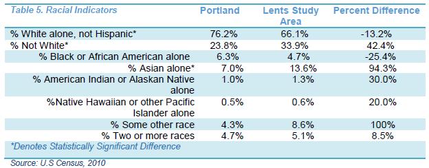
3 3


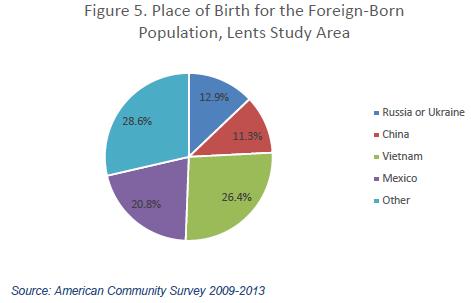
4 4
5 Interviews Four residents were asked a series of questions regarding their thoughts about living in the floodplain, their interactions or relationship with Johnson Creek, if and how their household and/or property has been effected by flooding or the threat of flooding, and what actions they would like to see the City, community leaders, or others take to reduce the burdens of living in the Johnson Creek floodplain. All four interviewees were white homeowners and lived in households with children. Interviewees have been living in their home in the floodplain for seven to ten years and also live in the Lents neighborhood. When asked what they enjoy about living in the Lents neighborhood, interviewees mentioned the location, proximity to public transportation and nature, affordability, ability to have a yard, and good neighbors. All participants mentioned enjoying the benefits of living near Johnson Creek, especially the recently completed Foster Floodplain Natural Area. When asked about the cons of their neighborhood, interviewees mentioned the homeless population, squatters, upkeep of homes, overall appearance, lack of economic attention from the City and quality of amenities that inner Portland neighborhoods have. None of the four interviewees have experienced flooding on their property. When asked what measures (if any) are taken to prevent property damage, interviewees mentioned that raising their homes is cost prohibitive. Instead, most carry flood insurance and follow common sense practices like keeping important documents and materials up on shelves. Three out of the four interviewees didn t know that they would have to pay flood insurance before they signed the final papers when purchasing their homes. One interviewer said that had his household known about the flood insurance before they were signing the papers on their house, they likely would have continued their search for another house outside the floodplain. Interviewees mentioned paying $700-$1,800 per year in flood insurance. Two interviewees stated that their insurance went up by 25% in one year. Only one interviewee was able to take action to reduce his flood insurance payment: he decided to pay off his mortgage to avoid paying flood insurance after he saw his insurance rate double in five years. Living in a floodplain affects community livability and can be a strong emotional drain during the rainy season. One interviewee explained how he checks the weather and rain predictions every day during the winter to make sure he doesn t need to rush home and make sure his basement is flood proof. Interviewees appreciated the work that the City has done to date to mitigate flooding, however most advocated for a way to reduce the burden of flood insurance. Interviewees also requested that the City provide information about which agencies have jurisdiction over which flood-related issues. Interviewees think that more outreach could be done about the elevation survey, and more effort should be taken to ensure that residents have access to the correct FEMA floodplain map. 5
Disaster Insurance: Are States and Insurance Companies Prepared?
 Disaster Insurance: Are States and Insurance Companies Prepared? National Conference of State Legislatures 2015 Legislative Summit Roy Wright Deputy Associate Administrator for Insurance and Mitigation
Many of the changes to the NFIP were recently revised on March 21, 2014 by the Homeowner Flood Insurance Affordability Act of 2014.
 F l oodawa r e ne swe e k Ma r c h19-ma r c h25 2017 Below is a summary of the topics we will discuss today. On July 6, 2012, the Biggert-Waters Flood Insurance Reform Act of 2012 was passed by Congress
FloodSmart Flood Risk and Flood Insurance. Georgia Floodplain Management March 14, 2013 Beth Cohorst, FloodSmart
 FloodSmart Flood Risk and Flood Insurance Georgia Floodplain Management March 14, 2013 Beth Cohorst, FloodSmart Presentation Overview FloodSmart Overview Mitigation, Flood Insurance and You The Risk and
Aquidneck Island Resilience Strategy Issue Paper 4. Issue: RESIDENTIAL FLOODING
 Aquidneck Island Resilience Strategy Issue Paper 4 Issue: RESIDENTIAL FLOODING Description of Concern: While much of Aquidneck Island s geography lies outside the reach of coastal flooding, some of the
City of Pensacola and Escambia County Flood Risk and Flood Insurance Study
 City of Pensacola and Escambia County Flood Risk and Flood Insurance Study Preliminary Report 1: Long Hollow and Sanders Beach Tracts Wharton Risk Management and Decision Processes Center November 8, 2016
REAL ESTATE FLOOD DISCLOSURE PROGRAM & FLOOD MAP INFORMATION SERVICES
 REAL ESTATE FLOOD DISCLOSURE PROGRAM & FLOOD MAP INFORMATION SERVICES Lisa Foster, CFM, Floodplain Coordinator ldfoster@pinellascounty.org January 26, 2018 Why are you here? Save your clients money on
BRANDI GABBARD CHAIR, NATIONAL ASSOCIATION OF REALTORS INSURANCE COMMITTEE COUNCIL MEMBER, CITY OF ST. PETERSBURG, FL
 BUILDING CLIMATE RESILIENCE IN THE REAL ESTATE SECTOR BRANDI GABBARD CHAIR, NATIONAL ASSOCIATION OF REALTORS INSURANCE COMMITTEE COUNCIL MEMBER, CITY OF ST. PETERSBURG, FL RESILIENCY THE ABILITY TO PREPARE
Population in the U.S. Floodplains
 D ATA B R I E F D E C E M B E R 2 0 1 7 Population in the U.S. Floodplains Population in the U.S. Floodplains As sea levels rise due to climate change, planners and policymakers in flood-prone areas must
REAL ESTATE FLOOD DISCLOSURE PROGRAM & FLOOD MAP INFORMATION SERVICES
 REAL ESTATE FLOOD DISCLOSURE PROGRAM & FLOOD MAP INFORMATION SERVICES Lisa Foster, CFM, Floodplain Coordinator ldfoster@pinellascounty.org January 26, 2018 Why are you here? Save your clients money on
Office of the Flood Insurance Advocate.
 Office of the Flood Insurance Advocate http://www.fema.gov/national-flood-insurance-programflood-insurance-advocate The OFIA s Mission The Office of the Flood Insurance Advocate (OFIA) advocates for the
Meeting the Energy Needs of Low-Income Households in Connecticut Final Report
 Meeting the Energy Needs of Low-Income Households in Connecticut Final Report Prepared for Operation Fuel, Inc / December 2016 Table of Contents Table of Contents Executive Summary... i Study Methodology...
Chapter 10 Equity and Environmental Justice
 Chapter 10 Equity and Environmental Justice Introduction An important consideration for the 2040 Transportation Policy Plan is its impact on all populations in the Minneapolis-Saint Paul region, particularly
FEMA FLOOD MAPS Public Works Department Stormwater Management Division March 6, 2018
 FEMA FLOOD MAPS Public Works Department Stormwater Management Division March 6, 2018 Presentation Overview FEMA National Flood Insurance Program (NFIP) FEMA Community Rating System (CRS) Flood Insurance
A Little Less Conversation a Little More ACTION! Louie Greenwell, GISP, CFM T&M Associates Carey Johnson KY Division of Water
 A Little Less Conversation a Little More ACTION! Louie Greenwell, GISP, CFM T&M Associates Carey Johnson KY Division of Water Topics Covered It s all about ACTION! Kentucky s plan for delivering actions
Upper Joachim Creek Public Survey on Potential Flood Risk Reduction
 Upper Joachim Creek Public Survey on Potential Flood Risk Reduction This survey is intended to help the interagency planning committee to receive public feedback on specific flood risk reduction techniques,
In the first three months of 2007, there
 Subprime Lending and Foreclosure in Hennepin and Ramsey Counties by Jeff Crump In the first three months of 2007, there were 678 foreclosure sales in the city of Minneapolis, an increase of more than 100%
Pierce County, Wisconsin. Bridge at Trenton Island. Photo by Rebecca Kihslinger.
 Pierce County, Wisconsin Bridge at Trenton Island. Photo by Rebecca Kihslinger. Background Pierce County (pop. 41,019) is located in northwestern Wisconsin and shares a border with Minnesota along the
Flood Insurance Reform Act of 2012
 Flood Insurance Reform Act of 2012 Impact of changes to the NFIP Note: This Fact Sheet deals specifically with Sections 205 and 207 of the Act. In 2012, the U.S. Congress passed the Flood Insurance Reform
TESTIMONY. Association of State Floodplain Managers, Inc.
 ASSOCIATION OF STATE FLOODPLAIN MANAGERS, INC. 2809 Fish Hatchery Road, Suite 204, Madison, Wisconsin 53713 www.floods.org Phone: 608-274-0123 Fax: 608-274-0696 Email: asfpm@floods.org TESTIMONY Association
Truckloads (at 25 tons/truck) of building debris 90
 of building debris 90") Marlborough Marlborough is a rural community in Hartford County covering a land area of 23.3 square miles and with an estimated population of 6,410. Elevation ranges from about 160 to 800 feet. The Town
Marlborough Marlborough is a rural community in Hartford County covering a land area of 23.3 square miles and with an estimated population of 6,410. Elevation ranges from about 160 to 800 feet. The Town
University Drive Flood Risk Management Project Phase I 58 th Ave S to 500 S of 64 th Ave S City of Fargo Project FM-15-C1
 University Drive Flood Risk Management Project Phase I 58 th Ave S to 500 S of 64 th Ave S City of Fargo Project FM-15-C1 Public Informational Meeting October 15, 2015 6:00 P.M. Overview Flood Risk FEMA
FREQUENTLY ASKED QUESTION ABOUT FLOODPLAINS Michigan Department of Environmental Quality
 FREQUENTLY ASKED QUESTION ABOUT FLOODPLAINS Michigan Department of Environmental Quality WHAT IS A FLOOD? The National Flood Insurance Program defines a flood as a general and temporary condition of partial
Gail Moldovan-Trujillo, ACSR,CPIW Hagan Hamilton Insurance 2012 NFIP Agency of the year Flood Insurance Specialist & Consultant
 Gail Moldovan-Trujillo, ACSR,CPIW Hagan Hamilton Insurance 2012 NFIP Agency of the year Flood Insurance Specialist & Consultant Flood Insurance regulations continue to change at a very rapid pace, therefore
in coordination with Peoria County, Planning and Zoning Department
 Prepared by Amec Foster Wheeler Environment & Infrastructure Hazard Mitigation and Emergency Management Program in coordination with Peoria County, Planning and Zoning Department The purpose of hazard
The National Flood Insurance Program and Flood Insurance Rate Map for San Francisco. Presentation at Treasure Island Community Meeting
 The National Flood Insurance Program and Flood Insurance Rate Map for San Francisco Presentation at Treasure Island Community Meeting October 17, 2007 1 National Flood Insurance Program (NFIP) Overview
Simsbury. Challenges Capitol Region Natural Hazards Mitigation Plan Update - Page 356
 Simsbury Simsbury is a suburban community of about 23,600 located in the western portion of the Capitol Region. Its land area encompasses 33.9 square miles. Elevation in town generally ranges from about
REAL ESTATE FLOOD DISCLOSURE PROGRAM & FLOOD MAP INFORMATION SERVICES
 REAL ESTATE FLOOD DISCLOSURE PROGRAM & FLOOD MAP INFORMATION SERVICES Agenda 10:30-12:00 Flood Disclosure Program 12:00-12:30 Lunch 12:30-1:30 Flood Map Service Center Lisa Foster, CFM, Floodplain Coordinator
Planning Commission April 19, 2017 Erin Cooper, Floodplain Specialist Varda Blum, Floodplain Program Manger
 Public Hearing for Z-17-0001: Zoning Map Amendments to the Floodplain Overlay District & DC-17-0001: Land Use Code text amendments to the Floodplain regulations Planning Commission April 19, 2017 Erin
A Floodsmart Future Strategic Flood Risk Management in Brisbane Authors: Ellen Davidge (Brisbane City Council), Greg Rogencamp (Sinclair Knight Merz)
, Greg Rogencamp (Sinclair Knight Merz)") 53 rd Annual Floodplain Management Authorities Conference A Floodsmart Future Strategic Flood Risk Management in Brisbane Authors: Ellen Davidge (Brisbane City Council), Greg Rogencamp (Sinclair Knight
53 rd Annual Floodplain Management Authorities Conference A Floodsmart Future Strategic Flood Risk Management in Brisbane Authors: Ellen Davidge (Brisbane City Council), Greg Rogencamp (Sinclair Knight
Use of FEMA Non regulatory Flood Risk Products in Planning
 Use of FEMA Non regulatory Flood Risk Products in Planning Georgia Association of Floodplain Managers Annual Conference March 24, 2016 What are the Non regulatory Flood Risk products? Go beyond the basic
CITY OF VESTAVIA HILLS
 CITY OF VESTAVIA HILLS FLOODPLAIN MANAGEMENT PLAN KICK-OFF MEETING MARCH 10, 2015 FLOODPLAIN MANAGEMENT PLANNING COMMITTEE Representative of the following categories Preventive Maintenance (e.g., codes)
On March 21, 2014, President Obama signed the Homeowner Flood Insurance Affordability Act of 2014 into law.
 On March 21, 2014, President Obama signed the Homeowner Flood Insurance Affordability Act of 2014 into law. This law repeals and modifies certain provisions of the Biggert-Waters Flood Insurance Reform
Granting Floodplain Development Variances: Things to Consider for Compliance in the NFIP
 Granting Floodplain Development Variances: Things to Consider for Compliance in the NFIP Flooding is Mississippi s number one natural disaster potential and as such, many of our communities have been proactive
Flood Management Amendments
 to the Johnson Creek Basin Plan District FINAL REPORT Adopted by the Portland City Council on April 29, 1998 Effective May 13, 1998 Bureau of Planning Portland, Oregon April 30, 1998 Johnson Creek Plan
Changes to the National Flood Insurance Program: From Biggert to Grimm Waters. Click to edit Master title style. Click to edit Master subtitle style
 Changes to the National Flood Insurance Program: Click to edit Master title style From Biggert to Grimm Waters Click to edit Master subtitle style Thomas Ruppert Coastal Planning Specialist With thanks
Changes Coming to the National Flood Insurance Program What to Expect. Impact of changes to the NFIP under Section 205 of the Biggert-Waters Act
 Changes Coming to the National Flood Insurance Program What to Expect Impact of changes to the NFIP under Section 205 of the Biggert-Waters Act Flood Risk Flood risks and the costs of flooding Weather
9/14/2012. Floodplain Basics the 100 year Flood. Columbus & Bartholomew County Flood Regulation Study Committee. Bartholomew County Floodplains
 Floodplain Basics the 100 year Flood Columbus & Bartholomew County Flood Regulation Study Committee 100-year Floodplain Purdue Land Use Team Video Seminar Series September 17, 2012 Floodway 1.2 inches
INFORMED DECISIONS ON CATASTROPHE RISK
 ISSUE BRIEF INFORMED DECISIONS ON CATASTROPHE RISK Analysis of Flood Insurance Protection: The Case of the Rockaway Peninsula in New York City Summer 2013 The Rockaway Peninsula (RP) in New York City was
The Future of Floodplain Management in Kentucky
 The Future of Floodplain Management in Kentucky Outline Background Federal Reauthorization Regulation Changes Insurance Changes Disclaimer All changes discussed in this presentation are PROPOSED ONLY.
Mapping Flood Risk in the Upper Fox River Basin:
 Mapping Flood Risk in the Upper Fox River Basin: Vulnerable Populations and Adverse Health Effects Presented by: Angelina Hanson STUDY AREA: Wisconsin's Upper Fox River Basin Total Population 139,309.
Multi-Jurisdictional. Multnomah County. Natural Hazards Mitigation Plan. Public Comment DRAFT Nov. 7, 2016
 Multnomah County Multi-Jurisdictional Natural Hazards Mitigation Plan Participating Jurisdictions: Multnomah County City of Fairview City of Gresham City of Troutdale City of Wood Village Public Comment
National Capitol Region HAZUS User Group Call
 Listen to the recording here to follow along with the presentation: http://www.freeconferencecalling.com/recordings/recording.aspx?fileid=l AF3494_04252013070630062_1154707&bridge=697620&email=&account
Flood Vulnerability Assessment for Critical Facilities. Molly Woloszyn Lisa Graff, GISP, CFM
 Flood Vulnerability Assessment for Critical Facilities Molly Woloszyn Lisa Graff, GISP, CFM 2011 University of Illinois Board of Trustees. All rights reserved. For permission information, contact the Illinois
Savannah :: Chatham. August rd Edition COMMUNITY INDICATORS DATABASE COUNTY CHATHAM. produced by the Armstrong Public Service Center
 photo: GA Dept. of Economic Development Savannah :: Chatham COMMUNITY INDICATORS DATABASE August 2013 3rd Edition produced by the Armstrong Public Service Center CHATHAM COUNTY www.savannah-chatham-indicators.org
Federal Flood Insurance Changes (National Flood Insurance Program NFIP)
") Federal Flood Insurance Changes (National Flood Insurance Program NFIP) Biggert-Waters (BW-12) Flood Insurance Reform Act 2012 HR 4348 Signed by the President on July 6, 2012 Public Works, Engineering
Federal Flood Insurance Changes (National Flood Insurance Program NFIP) Biggert-Waters (BW-12) Flood Insurance Reform Act 2012 HR 4348 Signed by the President on July 6, 2012 Public Works, Engineering
In 1993, spring came in like a lion, but refused
 36 UNIVERSITIES COUNCIL ON WATER RESOURCES ISSUE 130, PAGES 36-40, MARCH 2005 FEMA and Mitigation: Ten Years After the 1993 Midwest Flood Norbert Director of Federal Insurance and Mitigation Division Federal
Credit Research Center Seminar
 Credit Research Center Seminar Ensuring Fair Lending: What Do We Know about Pricing in Mortgage Markets and What Will the New HMDA Data Fields Tell US? www.msb.edu/prog/crc March 14, 2005 Introduction
Changes in Criteria and Scoring for CRS Outreach Projects
 Changes in Criteria and Scoring for CRS Outreach Projects A Handout for the National Flood Insurance Program Community Rating System Many communities want to keep disseminating and obtaining CRS credit
Floodplain Management Plan
 Floodplain Management Plan CITY OF FORT WORTH TFMA 2016 Spring Conference March 10, 2016 Agenda 1. Fort Worth Higher Standards (NFIP & CRS) 2. Floodplain Management Plan Overview and Results 3. Project
Frequently Asked Questions (FAQs)
") FLOODS Floods are one of the most common hazards in the United States. Flood effects can be local, impacting a neighborhood or community, or very large, affecting entire river basins and multiple states.
FLOODS Floods are one of the most common hazards in the United States. Flood effects can be local, impacting a neighborhood or community, or very large, affecting entire river basins and multiple states.
35 YEARS FLOOD INSURANCE CLAIMS
 40 RESOURCES NO. 191 WINTER 2016 A Look at 35 YEARS FLOOD INSURANCE CLAIMS of An analysis of more than one million flood claims under the National Flood Insurance Program reveals insights to help homeowners
2018 Alberta Pre-Budget Submission
 2018 Alberta Pre-Budget Submission Dear Minister Ceci, On behalf of our members, Insurance Bureau of Canada (IBC) is pleased to make recommendations as part of the Government of Alberta s 2018 pre-budget
David A. Stroud, CFM AMEC Earth & Environmental Raleigh, NC
 David A. Stroud, CFM AMEC Earth & Environmental Raleigh, NC Objectives Risk MAP background North Carolina s Risk MAP role Role of communication in Risk MAP Effective risk communication two examples Multi-hazard
Flooding Part One: BE Informed. Department of Planning & Development
 Flooding Part One: BE Informed Department of Planning & Development Introduction The residents of the City of Noblesville enjoy many benefits from being located on the banks of the White River. These benefits
Coalition of New York and New Jersey Flood Insurance Consumer Advocates
 Coalition of New York and New Jersey Flood Insurance Consumer Advocates Comments on the Flood Insurance Sustainability and Affordability Act of 2017 Title I: Enhancing National Flood Insurance Program
The Community Rating System in Coastal New England: Regional Approaches and Lessons Learned
 Session 4: Flood Insurance and the Community Rating System The Community Rating System in Coastal New England: Regional Approaches and Lessons Learned Abbie Sherwin - Maine Coastal Program Julie LaBranche
Flood Risk Assessment in the
 Georgia Flood M.A.P. Program Flood Risk Assessment in the Upper Chattahoochee h h River Basin GAFM Annual Conference March 28, 2012 Agenda Map Mod to Risk MAP (Georgia Flood M.A.P.) transition Flood Risk
Flood Insurance vs. Disaster Assistance. Janice Mitchell FEMA, Region
 Flood Insurance vs. Disaster Assistance Janice Mitchell FEMA, Region 4 770-220-5441 National Flood Insurance Program (NFIP) Nearly 20,000 communities participating 195,350,633 policies in force $37,417,000,898,700
Improving Korea s Disaster Risk Reduction Policy using the Sendai Framework
 , pp.185-189 http://dx.doi.org/10.14257/astl.2016.129.37 Improving Korea s Disaster Risk Reduction Policy using the Sendai Framework 2015-2030 Younhee Kim National Civil Defense and Disaster Management
NFIP Program Basics. KAMM Regional Training
 NFIP Program Basics KAMM Regional Training Floodplain 101 Homeowners insurance does not cover flood damage Approximately 25,000 flood insurance policies in KY According to BW12 analysis, approximately
Program Assessment Report 2017
 This document is made available electronically by the Minnesota Legislative Reference Library as part of an ongoing digital archiving project. http://www.leg.state.mn.us/lrl/lrl.asp Evaluating Affordable
FLOODPLAIN MANAGEMENT PLAN 2015 ANNUAL PROGRESS REPORT
 FLOODPLAIN MANAGEMENT PLAN 2015 ANNUAL PROGRESS REPORT Hinds County (Unincorporated) NFIP Community Number 280070 The 2015 Floodplain Management Plan Annual Progress Report on the progress made in implementing
Bucks County, PA Flood Risk Review Meeting. November 2014
 Bucks County, PA Flood Risk Review Meeting November 2014 Agenda for Today Risk MAP Program overview Overview of non-regulatory Flood Risk Products and datasets Discuss mitigation action Technical overview
Mitigation Strategies
 Mitigation Strategies Introduction Michigan State University Mitigation Goals Identification and Analysis of Mitigation Actions Recommendation and Prioritization of Mitigation Actions Potential Funding
HAZARD MITIGATION PLAN POINT OF CONTACT. MUNICIPAL PROFILE
 HAZARD MITIGATION PLAN POINT OF CONTACT troseberry@easton-pa.gov cmanges@easton-pa.gov MUNICIPAL PROFILE MUNICIPAL PARTICIPATION Compliance with the National Flood Insurance Program (NFIP) Identify source
LELAND CONSULTING GROUP
 Memorandum Date 25 April 2013 To From CC Thomas Puttman, Puttman Infrastructure April Chastain, Leland Consulting Group Chris Zahas, Leland Consulting Group Matt Arnold, SERA Architects Kevin Cronin, Portland
G318 Local Mitigation Planning Workshop. Module 2: Risk Assessment. Visual 2.0
 G318 Local Mitigation Planning Workshop Module 2: Risk Assessment Visual 2.0 Unit 1 Risk Assessment Visual 2.1 Risk Assessment Process that collects information and assigns values to risks to: Identify
Primer on Sea Level Rise and Future Flooding. Doug Marcy / Russell Jackson Coastal Hazards Specialists NOAA Office for Coastal Management
 Primer on Sea Level Rise and Future Flooding Doug Marcy / Russell Jackson Coastal Hazards Specialists NOAA Office for Coastal Management Sea Level has Changed Throughout Geologic History 1.7mm/year 2.9mm/year
The Changing NFIP, the CRS & Local Governments. Scott Pippin, J.D., M.E.P.D.
 The Changing NFIP, the CRS & Local Governments Scott Pippin, J.D., M.E.P.D. Flood Insurance Reform Biggert Waters 2012 (BW12) Homeowner Flood Insurance Affordability Act of 2014 (HFIAA) Bigger Waters 2012
Floodplain Management. City Council Work Session April 16, 2013
 Floodplain Management City Council Work Session April 16, 2013 1 Discussion Agenda Flood Insurance Rate Changes Community Rating System Recommendation Floodplain Ordinance Enhancements Modifications Public
Overview of Presentation
 Rocky Mountain Land Use Institute March 10, 2016 Overview of Presentation Why planning for hazards is important to Colorado Approaches to planning for hazards Overview of the planning for hazards guide
Kentucky Risk MAP It s not Map Mod II
 Kentucky Risk MAP It s not Map Mod II Risk Mapping Assessment and Planning Carey Johnson Kentucky Division of Water carey.johnson@ky.gov What is Risk MAP? Risk Mapping, Assessment, and Planning (Risk MAP)
PUBLIC AWARENESS SURVEY. Prepared by Cocker Fennessy, Inc.
 GREEN RIVER VALLEY FLOODING PUBLIC AWARENESS SURVEY Prepared by September 17, 2009 Objectives Assess public awareness & concern of flood risk Identify actions residents are taking to prepare Determine
The High Cost of Segregation: Exploring the Relationship Between Racial Segregation and Subprime Lending
 F u r m a n C e n t e r f o r r e a l e s t a t e & u r b a n p o l i c y N e w Y o r k U n i v e r s i t y s c h o o l o f l aw wa g n e r s c h o o l o f p u b l i c s e r v i c e n o v e m b e r 2 0
City of San Mateo Flood Zone Update. North Shoreview Neighborhood Meeting June 18, 2014
 City of San Mateo Flood Zone Update North Shoreview Neighborhood Meeting June 18, 2014 Introductions Open Statement - Council Member Goethals Technical Presentation City Staff Closing Comments - Council
COLLIER COUNTY FLOODPLAIN MANAGEMENT
 COLLIER COUNTY FLOODPLAIN MANAGEMENT FREQUENTLY ASKED QUESTIONS The following information is based on common questions from the public. If you have a specific question or need further information, please
Welcome to a Silver Jackets Webinar
 Welcome to a Silver Jackets Webinar The CRS and Repetitive Loss Area Analysis (RLAA) For audio, Dial: 877 336-1839 Access code: 5884527 Security code: 4567 Visual 10.1 David A. Stroud, CFM Emergency &
Michael Taylor, PE, CFM Project Manager, AECOM August 25, 2015
 Promoting FEMA s Flood Risk Products in the Lower Levisa Watershed Michael Taylor, PE, CFM Project Manager, AECOM August 25, 2015 Agenda Study Background Flood Risk Product Overview AOMI and Mitigation
ANNEX ANNEX. to the. Proposal for a COUNCIL DECISION. on guidelines for the employment policies of the Member States
 EUROPEAN COMMISSION Brussels, 22.11.2017 COM(2017) 677 final to the Proposal for a COUNCIL DECISION on guidelines for the employment policies of the Member States EN EN Guideline 5: Boosting the demand
ANNEX B: TOWN OF BLUE RIVER
 ANNEX B: TOWN OF BLUE RIVER B.1 Community Profile Figure B.1 shows a map of the Town of Blue River and its location within Summit County. Figure B.1. Map of Blue River Summit County (Blue River) Annex
2018 FMA Annual Conference in Reno, NV:
 Nevada Floodplain Management News V O L U M E INSIDE THIS ISSUE: Sustainability in 1 the Face of Change Community Rating System Workshop 2 CCRFCD Master Plan Update 3 Douglas Co. Stormwater Maintenance
CHAPTER THREE Natural Hazard Mitigation Strategy
 CHAPTER THREE Natural Hazard Mitigation Strategy Chapter 3 Section All Sections Updates to Section Revised Natural Hazards Introduction and all Sections to change Natural Hazards Subcommittee to Committee.
Flood Insurance THE TOPIC OCTOBER 2012
 Flood Insurance THE TOPIC OCTOBER 2012 Because of frequent flooding of the Mississippi River during the 1960s and the rising cost of taxpayer funded disaster relief for flood victims, in 1968 Congress
Flood Mitigation Workgroup. Kickoff Meeting Metro Hall, Room 106 May 11, 2015
 Flood Mitigation Workgroup Kickoff Meeting Metro Hall, Room 106 May 11, 2015 Flood Mitigation Workgroup May 11, 2015 Agenda 1. Opening and Introductions Greg Heitzman (MSD) 5 min 2. Workgroup Roles (Chair/Leader,
Financing Floods in Chicago. Sephra Thomas. GIS for Water Resources C E 394K. Dr. David Maidment
 Financing Floods in Chicago Sephra Thomas GIS for Water Resources C E 394K Dr. David Maidment Fall 2018 Abstract The objective of this term paper is to study the hydrology and social vulnerability of Chicago,
National Flood Insurance Program Making Sense of April 2019 Changes
 National Flood Insurance Program Making Sense of April 2019 Changes Foreword The National Flood Insurance Program (NFIP) provides an important means for property owners to protect themselves financially
In Baltimore City today, 20% of households live in poverty, but more than half of the
 Building Economic Opportunity in Baltimore: A Data Profile Baltimore Highlights In Baltimore City today, 20% of households live in poverty, but more than half of the city s population 55% is financially
Factors Influencing Perceptions of Climate and Weather Effects on Property Ownership
 Factors Influencing Perceptions of Climate and Weather Effects on Property Ownership Huili Hao¹, Patrick Long¹, and Scott Curtis 12 1. 1. Center for Sustainability: Tourism, Natural Resources, and the
Executive Summary. Introduction and Purpose. Scope
 Executive Summary Introduction and Purpose This is the first edition of the Los Angeles Unified School District All-Hazard Mitigation Plan, and through completion of this plan the District continues many
Third Appropriation Funding Recommendation
 Third Appropriation Funding Recommendation Context: It is currently anticipated but not confirmed that the State of Louisiana will receive an additional 51,435,000 allocation from the Department of Housing
Federal Flood Risk Management Standards. An Update on Federal Flood Resilience Standards
 Federal Flood Risk Management Standards An Update on Federal Flood Resilience Standards Purpose of Today s Briefing Facilitate the understanding of Executive Order (E.O.)13690 and its implementation Discuss
What Was Updated in 2004 in Hennepin Countywide Maps?
 What Was Updated in 2004 in Hennepin Countywide Maps? Combined the city and township maps into one countywide index Done by USACE Mainly digital capture of old floodplain boundaries; some spots with shifts
Door County Floodplain Program Informational Meeting
 Door County Floodplain Program Informational Meeting Door County Land Use Services Department Wisconsin Department of Natural Resources January 15, 2018 Floodplain = Land affected by flood event with a
Role of Disaster Insurance in Improving Resilience: An Expert Meeting The Resilient America Roundtable
 Role of Disaster Insurance in Improving Resilience: An Expert Meeting The Resilient America Roundtable National Academy of Science Washington, DC July 9, 2015 Roseville Demographics Primary population
Overview of Capabilities and Current Limitations
 Overview of Capabilities and Current Limitations Overview of the National Flood Risk Characterization Tool (NFRCT) Map based viewer of relative flood risk around the U.S., with supporting reports for more
A Review of Repetitive Floodloss Data for Hoey s Basin, Jefferson Parish, Louisiana
 A Review of Repetitive Floodloss Data for Hoey s Basin, Jefferson Parish, Louisiana Submitted to Jefferson Parish Councilmember Jennifer Sneed on behalf of the Hoey s Basin Drainage Alliance by the Center
Mitigation Works. 0 With its devastating combination of water, mud, and sewage, the damages caused by flooding are particularly wrenching.
 0 Nationwide, structures built to NFIP standards are estimated to suffer 80% less damage than other structures, and save more than $ 1 Billion in flood damages annually. 0 With its devastating combination
Identifying Opportunities. Aligning Resources. Community Commitment Plan Summary Report. Measuring Outcomes. Advancing What Works
 Identifying Opportunities 2016 Community Commitment Plan Summary Report Aligning Resources Measuring Outcomes Advancing What Works 2016 Community Commitment Highlights Helping to ensure the well-being
1.1. PURPOSE 1.2. AUTHORITIES 1. INTRODUCTION
 1. INTRODUCTION This section briefly describes hazard mitigation planning requirements, associated grants, and this Standard State Hazard Mitigation Plan (SHMP) update s composition. HMPs define natural