Sixteen Member County Watershed Management Forum July 12, 2017 NCTCOG, Centerpoint II Transportation Council Room AGENDA
|
|
|
- Kory Gallagher
- 5 years ago
- Views:
Transcription

1 North Central Texas Council of Governments Sixteen Member County Watershed Management Forum July 12, 2017 NCTCOG, Centerpoint II Transportation Council Room AGENDA Time Topic Speakers 9:30a-9:45a Welcome, Introductions, and Brief Summary of Mia Brown, CFM Why We re Here and Progress Made NCTCOG E&D 9:45a-10:05a 10:05a-10:10a Importance of the Sixteen County Watershed Management Effort for New Development Summary of the Regionally Recommended Standards in County Watershed Management, and Example Resources Available for Adoption Jessica Baker, PE, CFM, PMP TFMA/Halff Associates Jerry Cotter, PE USACE Chief Water Resources Edith Marvin, PE NCTCOG E&D 10:10a-10:30a Texas Water Code Amended in 2001 by Texas Senate Bill 936 (77R) John Ivey, PE, CFM TFMA/Halff Associates 10:30a-11:15a Forum Peer Discussion of the Legislation Enabling Texas Counties to Adopt the Regionally Recommended Standards in Watershed Management County Attorneys (Edith Marvin and Mia Brown facilitating) 11:15a Tools to Come and Next Steps Jerry Cotter and Edith Marvin If you have any questions regarding the meeting or agenda items, please contact Mia Brown: (817) ; If you plan to attend this public meeting and you have a disability that requires special arrangements at the meeting, please contact Crysta Guzman by phone at (817) or by at cguzman@nctcog.org 72 hours in advance of the meeting. Reasonable accommodations will be made to assist your needs. 616 Six Flags Drive, Centerpoint Two P.O. Box 5888, Arlington, Texas (817) FAX:

2 BUILDING STRONG
3 Introduction Importance of the Sixteen County Watershed Management Effort for New Development Summary of the Regionally Recommended Standards Texas Water Code Amended in 2001 by Texas Senate Bill 936 (77R) Forum Peer Discussion Tools to Come and Next Steps

4 Why Manage the Floodplains Date: 12 July 2017 Audience: 16 County Forum - NCTCOG By: Jerry L. Cotter P.E. Chief of Water Resources Fort Worth, US Army Corps of Engineers

5 Background Flooding in the US Floods are the leading cause of natural disaster losses in the US 30yr average = $7.96 billion in damages/year, 82 fatalities/year


 Somerville, TX")

6 Texas Is Subject to Extreme Flooding Record flooding 1000s of Structures impacted across TX and LA in $850M Damages in 2015 in TX alone (AP Photo/David J. Phillip) Somerville, TX 2016 Brazos River, 2016 Brandon Wade/Star-Telegram via AP Photos


7 Flooding Impacts Lives 48 deaths in Texas in deaths in Texas April June 2016


8 Flooding Impacts Transportation Infrastructure Largest loss of life Access issues Long rebuild schedules 10 s of millions


9 Flooding Impacts Water Systems Fort Worth water system impacted, 1949 Eastland County and Cisco, Texas loss of potable water system, memorial day 2016 flood Treatment plants Pipelines Can impact whole communities Cisco, Texas Water Treatment Plant Damaged


10 MGD Flooding Impacts Sanitary Sewer Systems TRA and USACE partner to mitigate flood impacts on regional sanitary sewer for DFW Uncertainty in determining flood potential Treatment plants Damaged pipelines Avg. Flow 2014 Avg. Flow Hr. Peak FY 2015
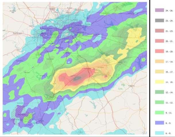

11 Corsicana, TX October 2015 Legend 24 Rainfall Center


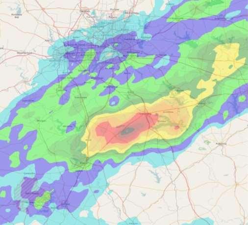
12 Clyde, TX October 1981 Legend 25 Rainfall Center 23 Rainfall Center


13 Brazos River Basin Reservoirs May 26-27, % Waco 22% Brenham, TX


14 Wimberley Flood May 2015 Legend Wimberley 14 Rainfall Center

15 Blanco River May 23-24, 2015 How Could This Happened? 12 Lives Lost, $30M Total Damages
16 Depth of Rainfall in Inches 24 Hour Rainfall for 10 Sq. Mi Depth of Rainfall for 10 Sq. Mi. 50-Year Extreme Events PMF Type 100-Year SPS PMP Events SPF Type Events

17 16 Extreme Rainfall Events Across Texas

18 Growth Animation 17


19 2010 Tropical Storm Hermine Flood Rush Creek, Arlington, TX 7-8 Rain over Rush Creek 11 Rain Less than design rainfall plus 2010 Drought, Why So Much Runoff?


20 Rush Creek Buyouts Arlington, Texas 49 homes 100 unit condominium $17 million total cost Repetitive loss buyouts $150k to $800k each year + 90% matching grant Causes Lack of regulatory products Inadequate regulatory products Upstream urbanization Vegetation management


21 Onion Creek Buyouts Austin, TX Federal project 483 to be purchased $30 million federal funding 1999 to still underway City of Austin project No federal funding 232 homes
 4 deaths 825 homes")


22 Onion Creek Buyouts Austin, TX October 2013 flood (Halloween Flood) 4 deaths 825 homes flooded in had already been purchased in federal buy-out Causes Lack of regulatory products Inadequate regulatory products Upstream development Rescue the rescuers

 886-1549 TEL")
23 Questions? Jerry L. Cotter, P.E. Chief Water Resources U.S. Army Corps of Engineers Fort Worth District (SWF) 819 Taylor Street Fort Worth, TX (817) TEL (817) CEL

24 NFIP created in 1968 to protect, insure lives and property from flood damage; establish regulatory framework Communities agree to regulate development in and around flood prone designated areas

25

26 Accurate Flood Risk Mapping Community Floodplain Administrator who implements development permit process
27


28 Meteorology How much rain Medium uncertainty Watershed Hydrology How much runoff High uncertainty River Hydraulics How deep will the water get Low uncertainty
29 These Regionally Recommended Standards in Watershed Management for New Development Within County Regulated Areas were developed by the North Central Texas Countywide Watershed Management Roundtable held on March 14, 2017.
30 Collin County Flood Damage Prevention Regulations - Denton County Flood Damage Prevention Regulations - Planning/PDFs/LRR/2011/2011-Floodplain-Regulations.pdf?la=en Dallas County Floodplain Management Regulations - Tarrant County Flood Damage Prevention Rules - /FP_Regulations_2011.pdf Collin County Subdivision Regulations - Denton County Planning Department Subdivision Process - Planning/PDFs/LRR/2009/Final-09-Rules-and-Regs.pdf?la=en
31 Dallas County Floodplain Management Regulations state: Floodplain management regulations means zoning ordinances, subdivision regulations, building codes, health regulations, special purpose ordinances (such as a floodplain ordinance, grading ordinance and erosion control ordinances) and other applications of police power. The term describes such state or local regulations, in any combination thereof, which provide standards for the purpose of flood damage prevention and reduction. Sec Methods of reducing flood losses. In order to accomplish its purposes, this article uses the following methods: (1) Restricts or prohibits uses that are dangerous to health, safety or property in times of flood, or cause excessive increases in flood heights or velocities; (2) Requires that uses vulnerable to floods, including facilities which serve such uses, be protected against flood damage at the time of initial construction; (3) Controls the alteration of natural floodplains, stream channels, and natural protective barriers, which are involved in the accommodation of flood waters; (4) Controls filling, grading, dredging and other development which may increase flood damage; (5) Prevents or regulates the construction of flood barriers which will unnaturally divert flood waters or which may increase flood hazards to other lands.
32 Collin County Flood Damage Prevention Regulations state: (1) Residential Construction - new construction and substantial improvement of any residential structure shall have the lowest floor (including basement), elevated to two (2) feet above the base flood elevation. (2) Nonresidential Construction - new construction and substantial improvements of any commercial, industrial or other nonresidential structure shall either have the lowest floor (including basement) elevated to two (2) feet above the base flood level or Section C. Standards for Subdivision Proposals: (4)Base flood elevation data shall be generated by a detailed engineering study for all Zone A areas, within 100 feet of the contour lines of Zone A areas, and other streams not mapped by FEMA, as indicated on the FIRM. Collin County Subdivision Regulations state: E. DRAINAGE & TOPOGRAPHY The drainage calculations shall be sufficiently detailed to determine changes in the 100-year floodplain elevation, water discharge and velocities within the subdivision and upstream and downstream of the subdivision, and Pre and Post construction Runoff values and means of mitigating any increased runoff.
33 Collin County Subdivision Regulations state: E. DRAINAGE & TOPOGRAPHY Locations of drainage easements will be shown. Drainage easements shall generally be located along the existing drainage way, and shall meet the following standards: a. Open channels with top widths from 0 to 50 requires top width plus 25. b. Open channels with top widths greater than 50 requires, top width plus 25 each side. c. Enclosed pipe require 20 minimum width. All easements shall be so designed to allow maintenance equipment to enter the easement, and be able to perform the necessary work. A. DRAWING REQUIREMENTS The recording plat shall be 24 x 36" and shall be on translucent Mylar. The following statements and information shall be noted on the face of the final plat: 2. The existing creeks or drainage channels traversing along or across the addition will remain as open channels and will be maintained by individual owners of the lot or lots that are traversed by or adjacent to the drainage course along or across said lots.
34 Collin County Subdivision Regulations state: Environmental - Based on Collin County Park and Open Space Strategic Plan, the developer, together with the County, shall make every effort to preserve natural resources such as the following: 1. Floodplains, wetlands and natural drainage ways; 2. Unique vegetation areas such as forests, native prairies or grasslands, wooded stream corridors, mature trees and marsh lands; 3. Unique wildlife habitat areas; 4. Areas with soils that are highly suited for agricultural production; 5. Areas with soils that are highly erosive and/or have limitations because of excessive slope (20% or greater); and 6. Scenic views of underdeveloped or limited developed (but compatible) landscapes along United States of America. State of Texas or major County roads that could maintain the rural countryside and beauty of the county. 7. Collin County, at the discretion of Commissioners' Court, shall make every reasonable effort to provide incentives for implementation of the above environmental factors. Creative land planning is encouraged to maximize the number of building sites, minimize development costs, and preserve the natural resources that contribute to the beauty of Collin County.
35 Denton County Flood Damage Prevention Regulations state: Permit Proceedures - (h) The top of the slab of the lowest habitable floor must be elevated to two (2) feet or more above the base flood elevation. (v) Any reduction in floodplain storage or conveyance capacity must be offset with a hydraulically equivalent (one-to-one) volume of mitigation sufficient to offset the reduction. The reduction may result from development or the placement of fill within the floodplain. Denton County Subdivision Regulations state: 17. IMPROVEMENTS STATEMENT: Blocking the flow of water or constructing improvements in surface drainage easements, and filling or obstructing the floodway is prohibited. The existing creeks or drainage channels traversing along or across the addition will remain as open channels and will be maintained by the individual property owners of the lot or lots that are traversed by or adjacent to the drainage courses along or across the lots.
36 Denton County Subdivision Regulations state: 17. IMPROVEMENTS STATEMENT: No construction, without written approval from Denton County shall be allowed within an identified FIRM floodplain area, and then only after a detailed floodplain development permit including engineering plans and studies show that no rise in the Base Flood Elevation (BFE) will result, that no flooding will result, that no obstruction to the natural flow of water will result; and subject to all owners of the property affected by such construction becoming a party to the request. Where construction is permitted, all finished floor elevations shall be a minimum of one foot above the 100-year flood elevation. ENGINEERING PLANS IV. Drainage Designs IV.1.5 Downstream Hydrologic Assessment It is the responsibility of all new development to assess downstream conditions and determine the likelihood that an adverse impact will be created. Where downstream conditions warrant, it will be the developer s responsibility to mitigate for increased peak discharge and increased erosion potential for 2, 5, 10, 25 and 100 return event storms.
37 Denton County Subdivision Regulations state: IV. - B. Drainage Design Criteria Storm Water Runoff Management: Denton County Storm Water Policy- it the intent of Denton County to have zero impact on properties adjacent to and or downstream of new subdivisions or developments. This shall be required of all new developments regardless of size. There is one condition that will serve as an exception to this requirement and that is when a point discharge would result if a detention pond or other drainage structure were to be constructed. Therefore, in cases where the overland distance of flow across the entire portion of the property being platted is less than three hundred feet (300 ) and can be clearly shown to have only sheet flow that does not concentrate flow, a drainage plan clearly showing this condition will be all that is required to be submitted. If it is known that the final usage of such a property will result in a drainage runoff coefficient greater than 0.50 this exception will not apply and some form of storm water management will be required. There are several accepted methods of providing protection and safety for these downstream properties that can be used. They are: Storm Water Detention Storm Water Detention involves collecting excess runoff before it enters the main
38 Denton County Subdivision Regulations state: ENGINEERING PLANS IV. Drainage Designs IV.2.1 General Design Considerations - Design Storm Requirements All calculations shall assume full development watershed conditions. IV.2.2 On-Site Flood Control System Design - Design Frequency See Section IV.2.1 for design storm requirements for the sizing of storm system components. Fully developed conditions should be used for design. Flow Spread Limits - Road side ditches and inlets shall be spaced so that the spread in the street for the design flow shall not exceed the following, as measured from the face of the curb: 8 feet if the street is classified as a Collector or Arterial street (for 4-lane streets or greater, spread may extend across one travel lane) 16 feet at any given section, but in no case greater than 10 feet on one side of the street, if the street is classified as a Local street A minimum of one 12-foot lane shall remain clear in a 100-year return-event storm for all roadway classifications.
39 Denton County Subdivision Regulations state: ENGINEERING PLANS IV. Drainage Designs IV.3.3 Bridge Design Frequency Flood All bridge design shall include 100-year return event discharges, assuming fully developed watershed conditions. D. Design should be for fully developed watershed conditions. If the available discharges are from FEMA existing conditions hydrology, the following options are available: (1) obtain new hydrology, (2) extrapolate fully-developed from existing data, or (3) variance from the County Engineer on design discharges
40
41 The State specifically address the NFIP in the Texas Water Code under Section 16 Subchapter I. Flood Insurance PURPOSE. The State of Texas recognizes the personal hardships and economic distress caused by flood disasters since it has become uneconomic for the private insurance industry alone to make flood insurance available to those in need of such protection on reasonable terms and conditions. Recognizing the burden of the nation's resources, congress enacted the National Flood Insurance Act of 1968, as amended (42 U.S.C. Sections 4001 through 4127), whereby flood insurance can be made available through coordinated efforts of the federal government and the private insurance industry, by pooling risks, and the positive cooperation of state and local government. The purpose of this subchapter is to evidence a positive interest in securing flood insurance coverage under this federal program and to so procure for those citizens of Texas desiring to participate and in promoting the public interest by providing appropriate protection against the perils of flood losses and in encouraging sound land use by minimizing exposure of property to flood losses. Amended by Acts 1977, 65th Leg., p. 2207, ch. 870, 1, eff. Sept. 1, 1977.
42 Additionally, The Texas Water Code states: NATIONAL FLOOD INSURANCE PROGRAM ORDERS OR ORDINANCES. The governing body of each city and county shall adopt ordinances or orders, as appropriate, necessary for the city or county to be eligible to participate in the National Flood Insurance Program. To be eligible to participate the political subdivision must be able to qualify under the requirement of 44 CFR, Subchapter B Insurance and Hazard Mitigation criteria. 44 CFR 59.2 (b) To qualify for the sale of federally-subsidized flood insurance a community must adopt and submit to the Federal Insurance Administrator. as part of its application, flood plain management regulations, satisfying at a minimum the criteria set forth at part 60 of this subchapter, designed to reduce or avoid future flood, mudslide (i.e., mudflow) or flood-related erosion damages. These regulations must include effective enforcement provisions.
43 The Texas Water Code goes on say: POLITICAL SUBDIVISIONS; COMPLIANCE WITH FEDERAL REQUIREMENTS. All political subdivisions are hereby authorized to take all necessary and reasonable actions to comply with the requirements and criteria of the National Flood Insurance Program, including but not limited to: (1) making appropriate land use adjustments to constrict the development of land which is exposed to flood damage and minimize damage caused by flood losses; (2) guiding the development of proposed future construction, where practicable, away from a location which is threatened by flood hazards; (3) assisting in minimizing damage caused by floods; (4) authorizing and engaging in continuing studies of flood hazards in order to facilitate a constant reappraisal of the flood insurance program and its effect on land use requirements; (5) engaging in floodplain management and adopting and enforcing permanent land use and control measures consistent with the criteria established under the National Flood Insurance Act; (6) declaring property, when such is the case, to be in violation of local laws, regulations, or ordinances which are intended to discourage or otherwise restrict land development or occupancy in flood-prone areas and notifying the director, or whomever the director designates, of such property; (7) consulting with, giving information to, and entering into agreements with the Federal Emergency Management Agency for the purpose of: (A) identifying and publishing information with respect to all flood areas, including coastal areas; and (B) establishing flood-risk zones in all such areas and making estimates with respect to the rates of probable flood-caused loss for the various flood-risk zones for each of these areas;
44 The Texas Water Code goes on say (continued): POLITICAL SUBDIVISIONS; COMPLIANCE WITH FEDERAL REQUIREMENTS. All political subdivisions are hereby authorized to take all necessary and reasonable actions to comply with the requirements and criteria of the National Flood Insurance Program, including but not limited to: (Continued) (8) cooperating with the director's studies and investigations with respect to the adequacy of local measures in flood-prone areas as to land management and use, flood control, flood zoning, and flood damage prevention; (9) taking steps, using regional, watershed, and multi-objective approaches, to improve the long-range management and use of flood-prone areas; (10) purchasing, leasing, and receiving property from the director when such property is owned by the federal government and lies within the boundaries of the political subdivision pursuant to agreements with the Federal Emergency Management Agency or other appropriate legal representative of the United States Government; (11) requesting aid pursuant to the entire authorization from the commission; (12) satisfying criteria adopted and promulgated by the commission pursuant to the National Flood Insurance Program; (13) adopting permanent land use and control measures with enforcement provisions which are consistent with the criteria for land management and use adopted by the director; (14) adopting more comprehensive floodplain management rules that the political subdivision determines are necessary for planning and appropriate to protect public health and safety; (15) participating in floodplain management and mitigation initiatives such as the National Flood Insurance Program's Community Rating System, Project Impact, or other initiatives developed by federal, state, or local government; and (16) collecting reasonable fees to cover the cost of administering a local floodplain management program. Amended by Acts 1977, 65th Leg., p. 2207, ch. 870, 1, eff. Sept. 1, 1977; Acts 1985, 69th Leg., ch. 795, 1.051, eff. Sept. 1, 1985; Acts 2001, 77th Leg., ch. 258, 2, eff. Sept. 1, 2001.
45 The Texas Water Code defines political subdivision to include Counties: Sec DEFINITIONS. In this subchapter: (1) "Political subdivision" means any political subdivision or body politic and corporate of the State of Texas and includes any county, river authority, conservation and reclamation district, water control and improvement district, water improvement district, water control and preservation district, fresh water supply district, irrigation district, and any type of district heretofore or hereafter created or organized or authorized to be created or organized pursuant to the provisions of Article XVI, Section 59 or Article III, Section 52 of the Constitution of the State of Texas; "political subdivision" also means any interstate compact commission to which the State of Texas is a party, municipal corporation, or city whether operating under the Home Rule Amendment of the Constitution or under the General Law.
46 The Texas Water Code additionally makes a statement in regards to Qualification : QUALIFICATION. Political subdivisions wishing to qualify under the National Flood Insurance Program shall have the authority to do so by complying with the directions of the Federal Emergency Management Agency and by: (1) evidencing to the director a positive interest in securing flood insurance coverage under the National Flood Insurance Program; and (2) giving to the director satisfactory assurance that measures will have been adopted for the political subdivision which measures will be consistent with the comprehensive criteria for land management and use developed by the Federal Emergency Management Agency. Amended by Acts 1977, 65th Leg., p. 2207, ch. 870, 1, eff. Sept. 1, 1977; Acts 1977, 65th Leg., 1st C.S., p. 58, ch. 4, 3, eff. Sept. 1, 1977; Acts 2001, 77th Leg., ch. 258, 4, eff. Sept. 1, 2001.
47 To address the question of actual enforcement ability, the level of penalty is defined in Texas Water Code Chapter 16, Subchapter I, Sec : Sec CIVIL PENALTY. A person who violates this subchapter or a rule adopted or order issued under this subchapter is subject to a civil penalty of not more than $100 for each act of violation and for each day of violation. Sec CRIMINAL PENALTY. (a) A person commits an offense if the person violates this subchapter. (b) An offense under this section is a Class C misdemeanor. (c) Each violation of this subchapter and each day of a continuing violation is a separate offense. Sec ENFORCEMENT BY POLITICAL SUBDIVISION. (a) If it appears that a person has violated, is violating, or is threatening to violate this subchapter or a rule adopted or order issued under this subchapter, a political subdivision may institute a civil suit in the appropriate court for: (1) injunctive relief to restrain the person from continuing the violation or threat of violation, including an order directing the person to remove illegal improvements and restore preexisting conditions; (2) the assessment and recovery of the civil penalty provided by Section ; or (3) both the injunctive relief and the civil penalty. (b) On application for injunctive relief and a finding that a person has violated, is violating, or is threatening to violate this subchapter or a rule adopted or order issued under this subchapter, the court shall grant the injunctive relief that the facts warrant.
48
49
50
CHAPTER 15: FLOODPLAIN OVERLAY DISTRICT "FP"
 CHAPTER 15: FLOODPLAIN OVERLAY DISTRICT "FP" SECTION 15.1 STATUTORY AUTHORIZATION The legislature of the State of Minnesota in Minnesota Statutes, Chapter 103F and Chapter 394 has delegated the responsibility
Article 23-6 FLOODPLAIN DISTRICT
 AMENDING THE CODE OF THE CITY OF PITTSFIELD CHAPTER 23, ZONING ORDINANCE SECTION I That the Code of the City of Pittsfield, Chapter 23, Article 23-6 Floodplain District, shall be replaced with the following:
Chapter 5 Floodplain Management
 Chapter 5 Floodplain Management Contents 1.0 Introduction... 1 2.0 Floodplain Management and Regulation... 1 2.1 City Code... 1 2.2 Floodplain Management... 1 2.3 Level of Flood Protection... 2 2.3.1 Standard
Chapter 6 - Floodplains
 Chapter 6 - Floodplains 6.1 Overview The goal of floodplain management is to reduce the potential risks to both existing and future developments, and infrastructure, in the 100-year floodplain. Over the
Guideline For Compliance With The Standards and Criteria of the National Flood Insurance Program
 Guideline For Compliance With The Standards and Criteria of the National Flood Insurance Program 160-5-4-.16 (a) 1 Educational Facility Site, Construction, and Reimbursement Facilities Services Unit Effective
Federal Emergency Management Agency
 Page 1 of 5 Issue Date: July 27, 2012 Effective Date: December 10, 2012 Case No.: 11-06-4512P Follows Conditional Case No.: 06-06-B789R LOMR-APP Federal Emergency Management Agency Washington, D.C. 20472
Justification for Floodplain Regulatory Standards in Illinois
 Justification for Floodplain Regulatory Standards in Illinois Office of Water Resources Issue Paper April, 2015 Proactive Illinois floodplain and floodway regulatory standards have prevented billions of
FREQUENTLY ASKED QUESTION ABOUT FLOODPLAINS Michigan Department of Environmental Quality
 FREQUENTLY ASKED QUESTION ABOUT FLOODPLAINS Michigan Department of Environmental Quality WHAT IS A FLOOD? The National Flood Insurance Program defines a flood as a general and temporary condition of partial
Floodplain Development Permits A Technical Guidance Document
 Floodplain Development Permits A Technical Guidance Document To Prevent Loss of Life, Reduce Property Damage and to Protect and Enhance the Natural and Beneficial Functions of Floodplains Iredell County
a) Ensure public safety through reducing the threats to life and personal injury.
 Ensure public safety through reducing the threats to life and personal injury.") SECTION VII: FLOODPLAIN DISTRICT 7-1 Statement Of Purpose The purposes of the Floodplain District are to: a) Ensure public safety through reducing the threats to life and personal injury. b) Eliminate
SECTION VII: FLOODPLAIN DISTRICT 7-1 Statement Of Purpose The purposes of the Floodplain District are to: a) Ensure public safety through reducing the threats to life and personal injury. b) Eliminate
Floodplain Management 101. Mississippi Emergency Management Agency Floodplain Management Bureau
 Floodplain Management 101 Mississippi Emergency Management Agency Floodplain Management Bureau Stafford Act The Stafford Disaster Relief and Emergency Assistance Act (Stafford Act) (Public Law 100-707)
CRISP COUNTY, GEORGIA AND INCORPORATED AREAS
 CRISP COUNTY, GEORGIA AND INCORPORATED AREAS Community Name Community Number ARABI, CITY OF 130514 CORDELE, CITY OF 130214 CRISP COUNTY (UNINCORPORATED AREAS) 130504 Crisp County EFFECTIVE: SEPTEMBER 25,
TOWN OF KENT, CT PLANNING AND ZONING COMMISSION
 TOWN OF KENT, CT PLANNING AND ZONING COMMISSION FLOOD PLAIN MANAGEMENT REGULATIONS Whereas, Congress has determined that a National Flood Insurance Program would alleviate personal hardships and economic
No An act relating to regulation of flood hazard areas, river corridors, and stream alteration. (S.202)
") No. 138. An act relating to regulation of flood hazard areas, river corridors, and stream alteration. (S.202) It is hereby enacted by the General Assembly of the State of Vermont: Sec. 1. 10 V.S.A. chapter
No. 138. An act relating to regulation of flood hazard areas, river corridors, and stream alteration. (S.202) It is hereby enacted by the General Assembly of the State of Vermont: Sec. 1. 10 V.S.A. chapter
Wetzel County Floodplain Ordinance
 Wetzel County Floodplain Ordinance AUTHORITY AND PURPOSE: THE PROVISIONS OF THIS ORDINANCE HAVE BEEN PREPARED WITH THE INTENTION OF MEETING THE REQUIREMENTS OF SECTION 60.3 (D) OF THE NATIONAL FLOOD INSURANCE
Dealing With Unnumbered A Zones in Maine Floodplain Management
 Dealing With Unnumbered A Zones in Maine Floodplain Management The following is a list of acceptable methods that the State Floodplain Management Coordinator and the Federal Emergency Management Agency
FLOODPLAIN MANAGEMENT PROGRAM ASSESSMENT GUIDANCE MANUAL
 FLOODPLAIN MANAGEMENT PROGRAM ASSESSMENT GUIDANCE MANUAL Created by the TEXAS COLORADO RIVER FLOODPLAIN COALITION 2 nd Edition June 2002 TCRFC H 300 P.O. Box 220 Austin, TX 78767 tcrfc-info@tcrfc.org www.tcrfc.org
Federal Emergency Management Agency
 Page 1 of 4 Issue Date: April 26, 2013 DETERMINATION DOCUMENT COMMUNITY AND REVISION INFORMATION PROJECT DESCRIPTION BASIS OF REQUEST City of Coppell Dallas County Texas FILL HYDRAULIC ANALYSIS NEW TOPOGRAPHIC
Flood Plain Management Services (FPMS) Program
 Program") Flood Plain Management Services (FPMS) Program 2016 Winter Stakeholder Partnering Forum March 2016 Mario Beddingfield, P.E., CFM Hydraulic Engineer/FPMS Program Manager H&H/Water Control Branch U.S. Army
Flood Plain Management Services (FPMS) Program 2016 Winter Stakeholder Partnering Forum March 2016 Mario Beddingfield, P.E., CFM Hydraulic Engineer/FPMS Program Manager H&H/Water Control Branch U.S. Army
Upper Joachim Creek Public Survey on Potential Flood Risk Reduction
 Upper Joachim Creek Public Survey on Potential Flood Risk Reduction This survey is intended to help the interagency planning committee to receive public feedback on specific flood risk reduction techniques,
HENRY COUNTY, OHIO SPECIAL PURPOSE FLOOD DAMAGE PREVENTION REGULATIONS TABLE OF CONTENTS
 HENRY COUNTY, OHIO SPECIAL PURPOSE FLOOD DAMAGE PREVENTION REGULATIONS TABLE OF CONTENTS TABLE OF CONTENTS... i-ii SECTION 1.0 STATUTORY AUTHORIZATION, FINDINGS OF FACT PURPOSE AND OBJECTIVES 1.1 STATUTORY
Volusia County Floodplain Management Plan 2012
 Volusia County Floodplain Management Plan 2012 Introduction The National Flood Insurance Program (NFIP) provides federally supported flood insurance in communities that regulate development in floodplains.
Pre-Development Floodplain Application
 Pre-Development Floodplain Application The Department of Planning, at the recommendation of FEMA, is now requiring completion of a Pre- Development Floodplain Application for all properties in the regulated
BUTTS COUNTY, GEORGIA AND INCORPORATED AREAS
 BUTTS COUNTY, GEORGIA AND INCORPORATED AREAS Butts County Community Name Community Number BUTTS COUNTY (UNICORPORATED AREAS) 130518 FLOVILLA, CITY OF 130283 JACKSON, CITY OF 130222 JENKINSBURG, TOWN OF
FLOOD DAMAGE PREVENTION RULES
 60.3(d) FLOOD DAMAGE PREVENTION RULES ARTICLE 1 STATUTORY AUTHORIZATION, FINDINGS OF FACT, PURPOSE AND METHODS SECTION A. STATUTORY AUTHORIZATION The Legislature of the State of Texas adopted the Flood
Floodplain Development Permit Application
 Floodplain Development Permit Application **All construction will also require a building permit** This is an application packet for a Floodplain Development Permit. Certain sections are to be completed
Planning Process---Requirement 201.6(b): An open public involvement process is essential to the development of an effective plan.
: An open public involvement process is essential to the development of an effective plan.") Section 3 Capability Identification Requirements Planning Process---Requirement 201.6(b): An open public involvement process is essential to the development of an effective plan. Documentation of the Planning
Section 3 Capability Identification Requirements Planning Process---Requirement 201.6(b): An open public involvement process is essential to the development of an effective plan. Documentation of the Planning
Federal Emergency Management Agency
 Page 1 of 4 Issue Date: August 1, 2012 Effective Date: December 13, 2012 Case No.: 12-06-0595P LOMR-APP Washington, D.C. 20472 LETTER OF MAP REVISION DETERMINATION DOCUMENT COMMUNITY AND REVISION INFORMATION
Federal Emergency Management Agency
 Page 1 of 4 Issue Date: September 7, 2012 Effective Date: January 22, 2013 DETERMINATION DOCUMENT COMMUNITY COMMUNITY AND REVISION INFORMATION City of Lubbock Lubbock County Texas PROJECT DESCRIPTION CHANNELIZATION
CHAPTER 8 FLOOD PREVENTION AND PROTECTION*
 CHAPTER 8 FLOOD PREVENTION AND PROTECTION* ---------- *Cross reference(s)--drainage commission, 2-111 et seq.; drainage districts created, 2-114; site drainage requirements for manufactured or mobile home
Federal Emergency Management Agency
 Page 1 of 5 Issue Date: June 21, 2013 Follows Conditional Case No.: 04-06-A148R DETERMINATION DOCUMENT COMMUNITY COMMUNITY AND REVISION INFORMATION City of Irving Dallas County Texas FILL PROJECT DESCRIPTION
NFIP Overview Elevation Certificate Flood Insurance Rate Maps. By: Maureen O Shea, AICP, CFM State NFIP Coordinator
 NFIP Overview Elevation Certificate Flood Insurance Rate Maps By: Maureen O Shea, AICP, CFM State NFIP Coordinator Example of a flood failure Example of a flood failure Purposes of the NFIP Identify &
SKOKOMISH RESERVATION FLOOD DAMAGE PREVENTION ORDINANCE TABLE OF CONTENTS
 TABLE OF CONTENTS STATUTORY AUTHORIZATION, FINDINGS OF FACT, PURPOSE, AND OBJECTIVES 6.04.001 Statutory Authorization 6.04.002 Findings of Fact 6.04.003 Statement of Purpose 6.04.004 Methods of Reducing
Bucks County, PA Flood Risk Review Meeting. November 2014
 Bucks County, PA Flood Risk Review Meeting November 2014 Agenda for Today Risk MAP Program overview Overview of non-regulatory Flood Risk Products and datasets Discuss mitigation action Technical overview
SECTION 9: MAPS AND DATA
 SECTION 9: MAPS AND DATA Contents 9.1. NFIP Maps and Data... 9-2 9.1.1. Adopting and enforcing NFIP floodplain maps and data... 9-2 9.1.2. Adopting and enforcing more restrictive data... 9-2 9.1.3. Annexations...
Appendix B. A Comparison of the Minimum NFIP Requirements and the CRS
 A Comparison of the Minimum s and the CRS The Community Rating System provides credits for exceeding the minimum requirements of the National Flood Insurance Program (NFIP). Many local officials are not
ADVISORY BASE FLOOD ELEVATIONS (ABFEs)
") The Department of Homeland Security s Federal Emergency Management Agency is committed to helping communities that were impacted by Hurricanes Katrina and Rita rebuild safer and stronger. Following catastrophic
The Department of Homeland Security s Federal Emergency Management Agency is committed to helping communities that were impacted by Hurricanes Katrina and Rita rebuild safer and stronger. Following catastrophic
INSTRUCTIONS FOR COMPLETING THE APPLICATION FORMS FOR CONDITIONAL LETTERS OF MAP REVISION AND LETTERS OF MAP REVISION
 INSTRUCTIONS FOR COMPLETING THE APPLICATION FORMS FOR CONDITIONAL LETTERS OF MAP REVISION AND LETTERS OF MAP REVISION GENERAL In 1968, the U.S. Congress passed the National Flood Insurance Act, which created
DES MOINES CITY OF TWO RIVERS. Flooding Risk & Impact to Development
 DES MOINES CITY OF TWO RIVERS Flooding Risk & Impact to Development River System Des Moines Flood Protection Des Moines Flood Protection cont. Infrastructure Over 24 miles of levees 21stormwater pump stations
City of St. Augustine. Floodplain Management Higher Standards Information
 City of St. Augustine Floodplain Management Higher Standards Information There are different regulations that communities can use to help protect existing and future development and natural floodplain
Nassau County 2030 Comprehensive Plan. Capital Improvements Element (CI) Goals, Objectives and Policies. Goal
 Goals, Objectives and Policies. Goal") (CI) Goal Based on the premise that existing taxpayers should not have to bear the financial burden of growth-related infrastructure needs, Ensure the orderly and efficient provision of infrastructure
(CI) Goal Based on the premise that existing taxpayers should not have to bear the financial burden of growth-related infrastructure needs, Ensure the orderly and efficient provision of infrastructure
Floodplain Development Permit Application
 Floodplain Development Permit Application City of Jonesboro, AR This is an application packet for a Floodplain Development Permit. Certain sections are to be completed by the Applicant, and certain sections
CITIZEN POTAWATOMI NATION PUBLIC CONSERVATION AND ENVIROMENTAL PROTECTION ACT TITLE 35
 CITIZEN POTAWATOMI NATION PUBLIC CONSERVATION AND ENVIROMENTAL PROTECTION ACT TITLE 35 CHAPTER SECTION 1 ESTABLISHMENT OF THE DEPARTMENT OF ENVIRONMENTAL PROTECTION Establishment 101 Required Reporting
Chapter 113 FLOODPLAIN MANAGEMENT ARTICLE I. IN GENERAL
 Chapter 113 FLOODPLAIN MANAGEMENT Sec. 113-1. Findings of Fact and Purpose. ARTICLE I. IN GENERAL Statutory Authorization: The legislature of the State of Minnesota has, in Minnesota Statutes Chapter 103F
17.13 FLOOD DAMAGE PREVENTION ORDINANCE. Article I. Statutory Authorization, Findings of Fact, Purpose, and Methods
 17.13 FLOOD DAMAGE PREVENTION ORDINANCE Article I Statutory Authorization, Findings of Fact, Purpose, and Methods 17.1301 Statutory Authorization. The Legislature of the State of South Dakota has in (statutes)
UPDATE ON DALLAS FLOODWAY
 UPDATE ON DALLAS FLOODWAY ENVIRONMENTAL IMPACT STATEMENT [ EIS ] Transportation and Trinity River Project Committee Rob Newman Director, Trinity River Corridor Project, Fort Worth District 28 April 2014
CHAPTER 4. REGULATIONS AND DEVELOPMENT STANDARDS
 CHAPTER 4. REGULATIONS AND DEVELOPMENT STANDARDS Regulations and development standards, which can be used by communities to reduce damage from natural hazards, work best when using an effective planning
JANUARY 13, ILL. ADM. CODE CH. I, SEC TITLE 17: CONSERVATION CHAPTER I: DEPARTMENT OF NATURAL RESOURCES SUBCHAPTER h: WATER RESOURCES
 TITLE 17: CONSERVATION CHAPTER I: DEPARTMENT OF NATURAL RESOURCES SUBCHAPTER h: WATER RESOURCES PART 3702 CONSTRUCTION AND MAINTENANCE OF DAMS Section Page No. 3702.10 Purpose 2 3702.20 Definitions 3 3702.30
Planning Process---Requirement 201.6(b): An open public involvement process is essential to the development of an effective plan.
: An open public involvement process is essential to the development of an effective plan.") Section 3 Capability Identification Requirements Planning Process---Requirement 201.6(b): An open public involvement process is essential to the development of an effective plan. Documentation of the Planning
Section 3 Capability Identification Requirements Planning Process---Requirement 201.6(b): An open public involvement process is essential to the development of an effective plan. Documentation of the Planning
RIO ARRIBA COUNTY FLOOD DAMAGE PREVENTION ORDINANCE
 RIO ARRIBA COUNTY FLOOD DAMAGE PREVENTION ORDINANCE NO. 1982-1 RE VISED 1988-2 AMENDED 2008-01 RIO ARRIBA J. FRED VIGIl, COUNTY CLERK 200707904 Book 530 Page 7904 1 of 22 10/30/2007 O8:5Q ~~ AM BY 1 FLOOD
BACKGROUND ANNUAL PROGRESS REPORT DEVELOPMENT ADOPTION OF THE H-GAC HAZARD MITIGATION PLAN/UPDATES MISSION STATEMENT
 BACKGROUND CITY OF CONROE FLOODPLAIN MANAGEMENT ANNUAL PROGRESS Activity 510 of the National Flood Insurance Program s (NFIP) Community Rating System (CRS) requires the development of a Floodplain Management
GENERAL PLAN AMENDMENT # FLOOD HAZARDS
 GENERAL PLAN AMENDMENT #2011-03 FLOOD HAZARDS The following text that appears on pages HS 3-4 of the Health and Safety Element in the Yolo 2030 Countywide General Plan has been amended. New language is
National Flood Insurance Program (NFIP) for Real Estate Professionals
 for Real Estate Professionals") National Flood Insurance Program (NFIP) for Real Estate Professionals 1 Joshua Oyer, CFM Outreach Specialist NFIP State Coordinator s Office at the Texas Water Development Board 2 Outline Introduction
National Flood Insurance Program (NFIP) for Real Estate Professionals 1 Joshua Oyer, CFM Outreach Specialist NFIP State Coordinator s Office at the Texas Water Development Board 2 Outline Introduction
Ordinance Number 1 % New Munich Floodplain Management Ordinance. September 10,2007
 Ordinance Number 1 % New Munich Floodplain Management Ordinance September 10,2007 SECTION 1.0 STATUTORY AUTHORIZATION, FINDINGS OF FACT AND PURPOSE 1 1.1 Statutory Authorization 1 1.2 Statement of Purpose
ATTACHMENT 1. Amendments to Chapter 18.20, Definitions Area of shallow flooding Area of special flood hazard
 Amendments to Chapter 18.20, Definitions 18.20.206 Area of shallow flooding Area of shallow flooding means a designated AO, or AH, AR/AO, AR/AH, or VO Zone on the a community's flood insurance rate map
Delaware River Basin Commission s Role in Flood Loss Reduction Efforts
 Delaware River Basin Commission s Role in Flood Loss Reduction Efforts There is a strong need to reduce flood vulnerability and damages in the Delaware River Basin. This paper presents the ongoing role
ORDINANCE # FLOOD DAMAGE PREVENTION ORDINANCE STATUTORY AUTHORIZATION, FINDINGS OF FACT, PURPOSE AND METHODS
 ORDINANCE # 304 - FLOOD DAMAGE PREVENTION ORDINANCE ARTICLE I STATUTORY AUTHORIZATION, FINDINGS OF FACT, PURPOSE AND METHODS SECTION A. STATUTORY AUTHORIZATION The Legislature of the State of South Dakota
HOW PLANNING FOR SEA LEVEL RISE CREATES FLOOD INSURANCE REDUCTIONS: THE GEORGIA CONTEXT. Hunter Jones 1 I. INTRODUCTION
 HOW PLANNING FOR SEA LEVEL RISE CREATES FLOOD INSURANCE REDUCTIONS: THE GEORGIA CONTEXT Hunter Jones 1 I. INTRODUCTION Flood insurance rates are rising for homeowners. One way local governments can create
This survey is expected to take approximately 20 minutes and must be completed in one session.
 State Flood Assessment Survey 1 Introduction Thank you for your willingness to participate in this online survey as part of the State Flood Assessment effort. This first step toward developing comprehensive
This survey is expected to take approximately 20 minutes and must be completed in one session.
 Introduction Thank you for your willingness to participate in this online survey as part of the State Flood Assessment effort. This first step toward developing comprehensive flood planning for Texas does
NATIONAL COUNCIL OF INSURANCE LEGISLATORS (NCOIL) State Flood Disaster Mitigation and Relief Model Act
 State Flood Disaster Mitigation and Relief Model Act") NATIONAL COUNCIL OF INSURANCE LEGISLATORS (NCOIL) State Flood Disaster Mitigation and Relief Model Act Amended by the NCOIL Property-Casualty Insurance Committee on July 11, 2008, and Executive Committee
NATIONAL COUNCIL OF INSURANCE LEGISLATORS (NCOIL) State Flood Disaster Mitigation and Relief Model Act Amended by the NCOIL Property-Casualty Insurance Committee on July 11, 2008, and Executive Committee
SECTION V THE LOCAL MITIGATION STRATEGY BLUEPRINT
 SECTION V THE LOCAL MITIGATION STRATEGY BLUEPRINT A. GUIDING MITIGATION PRINCIPLES The Local Mitigation Strategy (LMS) is Hillsborough County s program developed to reduce or eliminate all forms of losses
REGION X FLOOD DAMAGE PREVENTION ORDINANCE WASHINGTON MODEL (REVISED 5/13/2004)
") REGION X FLOOD DAMAGE PREVENTION ORDINANCE WASHINGTON MODEL (REVISED 5/13/2004) Close to 300 towns, cities, counties, and tribes within the State of Washington participate in the National Flood Insurance
REGION X FLOOD DAMAGE PREVENTION ORDINANCE WASHINGTON MODEL (REVISED 5/13/2004) Close to 300 towns, cities, counties, and tribes within the State of Washington participate in the National Flood Insurance
Kentucky Division of Water Permitting Floodplain Overview and Considerations
 Kentucky Division of Water Permitting Floodplain Overview and Considerations Presentation to: 2014 KAMM Conference Lake Barkley State Resort Park by Solitha Dharman Department for Environmental Protection
D R A F T. Flood Damage Prevention Regulations Huerfano County Colorado. CWCB Redline Review SECTION 1.0
 Flood Damage Prevention Regulations Huerfano County Colorado SECTION 1.0 STATUTORY AUTHORIZATION, FINDINGS OF FACT, PURPOSE AND OBJECTIONS 1.1 STATUTORY AUTHORIZATION The Legislature of the State of Colorado
Federal Emergency Management Agency
 Page 1 of 6 Issue Date: October 24, 2012 Effective Date: March 7, 2013 Case No.: LOMR-APP DETERMINATION DOCUMENT COMMUNITY AND REVISION INFORMATION PROJECT DESCRIPTION BASIS OF REQUEST City of Lubbock
Natural Hazards Mitigation Plan Kankakee County, Illinois Executive Summary
 1. Introduction Natural Hazards Mitigation Plan Kankakee County, Illinois Executive Summary Kankakee County is subject to natural hazards that threaten life, safety, health, and welfare and cause extensive
COLLIER COUNTY FLOODPLAIN MANAGEMENT
 COLLIER COUNTY FLOODPLAIN MANAGEMENT FREQUENTLY ASKED QUESTIONS The following information is based on common questions from the public. If you have a specific question or need further information, please
Flood Insurance THE TOPIC OCTOBER 2012
 Flood Insurance THE TOPIC OCTOBER 2012 Because of frequent flooding of the Mississippi River during the 1960s and the rising cost of taxpayer funded disaster relief for flood victims, in 1968 Congress
Floodplain Management Legal Issues. Making the Case for a No Adverse Impact Approach
 Floodplain Management Legal Issues Making the Case for a No Adverse Impact Approach The Association of State Floodplain Managers 2 ASFPM began more than 45 years ago as a grassroots organization of floodplain
WOOD COUNTY, WV FLOODPLAIN ORDINANCE TABLE OF CONTENTS
 WOOD COUNTY, WV FLOODPLAIN ORDINANCE TABLE OF CONTENTS ARTICLE I - GENERAL PROVISIONS 3 Section 1.1 Intent 3 Section 1.2 Abrogation and Greater Restrictions 3 Section 1.3 Applicability 3 Section 1.4 Matters
FLOOD DAMAGE PREVENTION ORDER. Hill County, Texas
 FLOOD DAMAGE PREVENTION ORDER Hill County, Texas June 10 2014 FLOOD DAMAGE PREVENTION ORDER Hill County, Texas TABLE OF CONTENTS ARTICLE 1 STATUTORY AUTHORIZATION, FINDINGS OF FACT, PURPOSE AND METHODS...
Natural Hazards Mitigation Plan. Executive Summary
 Natural Hazards Mitigation Plan Executive Summary 1. Introduction Kane County Illinois, is subject to natural hazards that threaten life and health and have caused extensive property damage. Floods struck
Action Items for Flood Risk Management on Wildcat Creek Interagency success with floodplain management plans and flood forecast inundation maps
 Presentation to USACE 2012 Flood Risk Management and Silver Jackets Joint Workshop, Harrisburg, Pennsylvania Action Items for Flood Risk Management on Wildcat Creek Interagency success with floodplain
CHAPTER 160 FLOOD PLAIN REGULATIONS
 CHAPTER 160 FLOOD PLAIN REGULATIONS 160.01 Statutory Authority 160.13 Special Shallow Flooding Areas Standards 160.02 Findings of Fact 160.14 Administration 160.03 Purpose 160.15 Flood Plain Development
Chapter 1040 General Floodplain Ordinance TABLE OF CONTENTS PAGE
 Chapter 1040 General Floodplain Ordinance TABLE OF CONTENTS PAGE SECTION 1.0 STATUTORY AUTHORIZATION, FINDINGS OF FACT AND PURPOSE 1 1.1 Statutory Authorization 1 1.2 Statement of Purpose 1 1.3 Warning
44 CFR PARTS 59 & 60 MINIMUM REQUIREMENTS
 44 CFR PARTS 59 & 60 MINIMUM REQUIREMENTS IMPACT ON LOCAL GOVERNMENT FLOODPLAIN ADMINISTRATORS ALAN M. ARMSTRONG, CFM, FPA HOW DID WE GET HERE? SOMETIMES PROACTIVE BUT GENERALLY REACTIVE PROACTIVE: DUE
Federal Emergency Management Agency
 Page 1 of 6 Issue Date: May 13 2016 Case No.: Follows Conditional Case No.: 14-05-0595R DETERMINATION DOCUMENT COMMUNITY AND REVISION INFORMATION PROECT DESCRIPTION BASIS OF REQUEST COMMUNITY Village of
Green Stormwater. Flood Risk Reduction. Infrastructure for. June Presented by: Kari Mackenbach, CFM ms consultants Lynn Mayo, PE, CFM AECOM
 Green Stormwater Infrastructure for Flood Risk Reduction June 2016 Presented by: Kari Mackenbach, CFM ms consultants Lynn Mayo, PE, CFM AECOM Topics 1. Proposed ASFPM Policy Paper 2. Background Why is
THE FLOOD HAZARD AREA Valda Opara New Jersey Department of Environmental Protection June 8, 2012
 THE FLOOD HAZARD AREA Valda Opara New Jersey Department of Environmental Protection June 8, 2012 Individual Permits Building Requirements 0% Net-fill Standards JET SKIING DURING A FLOOD ESCAPING THE FLOOD
California Building Code and the NFIP. John Ingargiola, Senior Engineer FEMA Building Science Branch
 California Building Code and the NFIP John Ingargiola, Senior Engineer FEMA Building Science Branch CA Major Disaster Declarations and Federal Assistance $21 $21 $76 $78 7 declarations, 2004-2016, total
Michael Taylor, PE, CFM Project Manager, AECOM August 25, 2015
 Promoting FEMA s Flood Risk Products in the Lower Levisa Watershed Michael Taylor, PE, CFM Project Manager, AECOM August 25, 2015 Agenda Study Background Flood Risk Product Overview AOMI and Mitigation
COASTAL HAZARD MITIGATION TOOLS AND TECHNIQUES
 COASTAL HAZARD MITIGATION TOOLS AND TECHNIQUES Beach Nourishment Responsible Agency/Party: Mitigation for: Management Effort: Federal and/or State sponsored projects Long- and short-term erosion Flood
Community Rating System. National Flood Insurance Program
 National Flood Insurance Program Community Rating System A Local Official s Guide to Saving Lives Preventing Property Damage Reducing the Cost of Flood Insurance FEMA B-573 / May 2015 How the Community
Appendix D - Floodplain Documents
 City of Aspen Urban Runoff Management Plan Appendix D - Floodplain Documents 1. Floodplain Development Permit 2. Elevation Certificate and Instructions 3. Floodproofing Certificate for Non-Residential
The Legal Aspects of the National Flood Insurance Program. Larissa Womack Senior Attorney MEMA
 The Legal Aspects of the National Flood Insurance Program Larissa Womack Senior Attorney MEMA *MEMA s legal staff may not provide legal advice to other agencies, persons or entities. Please refer to your
North Carolina Department of Public Safety Emergency Management Risk Management
 North Carolina Department of Public Safety Emergency Management Risk Management Roy Cooper, Governor Erik A. Hooks, Secretary Michael A. Sprayberry, Director INSTRUCTIONS FOR COMPLETING THE NORTH CAROLINA
Non Regulatory Risk MAP Products Flood Depth and Probability Grids
 Non Regulatory Risk MAP Products Flood Depth and Probability Grids Virginia Floodplain Management Association 2015 Floodplain Management Workshop October 29th, 2015 Nabil Ghalayini, P.E., PMP, D.WRE, CFM
JAXGIS FEMA Flood Hazard Mapping -- Frequently Asked Questions
 Flood Hazard Zone Designations Summary Zones starting with the letter 'A' (for instance, Zone A, Zone AE, Zone AH, Zone AO) denote a Special Flood Hazard Area, which can also be thought of as the 100-year
ORDINANCE NO A FLOOD DAMAGE PREVENTION ORDINANCE
 ORDINANCE NO. 692-14 A FLOOD DAMAGE PREVENTION ORDINANCE WHEREAS, for a community to participate in the National Flood Insurance Program NFIP, it must adopt and enforce floodplain management regulations
Federal Emergency Management Agency
 Page 1 of 3 COMMUNITY AND MAP PANEL INFORMATION COMMUNITY CITY OF MARGATE CITY, ATLANTIC COUNTY, NEW JERSEY LEGAL PROPERTY DESCRIPTION A parcel of land, as described in Deed recorded in Book 4826, page
THE GENERAL ASSEMBLY OF PENNSYLVANIA SENATE BILL INTRODUCED BY COSTA, FONTANA, BREWSTER, SCHWANK, RESCHENTHALER AND RAFFERTY, APRIL 18, 2018
 PRINTER'S NO. 1 THE GENERAL ASSEMBLY OF PENNSYLVANIA SENATE BILL No. 1 Session of 01 INTRODUCED BY COSTA, FONTANA, BREWSTER, SCHWANK, RESCHENTHALER AND RAFFERTY, APRIL 1, 01 REFERRED TO VETERANS AFFAIRS
CONTINUING AUTHORITIES PROJECT (CAP) Federal Interest Determination
 Federal Interest Determination") Date: 8 May 2013 Division: Great Lakes and Ohio River Division District: Nashville District CONTINUING AUTHORITIES PROJECT (CAP) Federal Interest Determination 1. Project: Cumberland River, Metropolitan
Date: 8 May 2013 Division: Great Lakes and Ohio River Division District: Nashville District CONTINUING AUTHORITIES PROJECT (CAP) Federal Interest Determination 1. Project: Cumberland River, Metropolitan
Reconstruction Implications
 Federal Emergency Management Agency (FEMA) Recovery Guidance Advisory Base Flood Elevation (ABFE) of April 12, 2006 Reconstruction Implications Presentation to: City of New Orleans July 6 th, 2006 Lambert
History of Floodplain Management in Ascension Parish
 History of Floodplain Management in Ascension Parish presented by: Kara Moree Floodplain Coordinator February 6, 2012 Floodplain 101 Floodplain 101 Base or 1% Flood: A flood having a 1% chance of being
Repetitive Loss Area Revisit # 6 Walter Road Area Jefferson Parish
 Repetitive Loss Area Revisit # 6 Walter Road Area Jefferson Parish www.floodhelp.uno.edu Supported by FEMA Acknowledgement The compilation if this report was managed by Erin Patton, CFM, a UNO-CHART Research
FLOODPLAIN DEVELOPMENT VARIANCE APPLICATION PACKET
 FLOODPLAIN DEVELOPMENT VARIANCE APPLICATION PACKET Sutter County Water Resources Department 1130 Civic Center Boulevard Yuba City, California, 95993 (530) 822-7400 Floodplain management regulations cannot
1. STATUTORY AUTHORIZATION, FINDINGS OF FACT, AND PURPOSES... 2
 ORDINANCE NO. 15-03 CAPE GIRARDEAU COUNTY FLOODPLAIN MANAGEMENT ORDINANCE ARTICLE # PAGE # 1. STATUTORY AUTHORIZATION, FINDINGS OF FACT, AND PURPOSES... 2 2. GENERAL PROVISIONS... 3 3. ADMINISTRATION...
DEPARTMENT OF THE ARMY OFFICE OF THE CHIEF OF ENGINEERS WASHINGTON, D.C
 .t DEPARTMENT OF THE ARMY OFFICE OF THE CHIEF OF ENGINEERS WASHINGTON, D.C. 20314-1000 REPLY TO A TTENTION OF: CECW-PE (l0-1-7a) 1 3 OCT 199B SUBJECT: Tampa Harbor, Big Bend Channel, Florida THE SECRETARY
STORMWATER MANAGEMENT FUND Department of Environmental Services
 Department of Environmental Services Mission: To implement a comprehensive stormwater management program that balances the following goals: 1) to reduce the potential for stormwater threats to public health,