Pacific Coastal Salmon Recovery Fund
|
|
|
- Wilfrid Smith
- 5 years ago
- Views:
Transcription
1 Pacific Coastal Salmon Recovery Fund Project Progress Report Format For FYs Send progress reports by by April 30, 2007 to the following address: Columbia River Inter-Tribal Fish Commission 729 N.E. Oregon Suite 200 Portland, Oregon ATTN: Laura Gephart (503) View the PCSRF website address ( and go under the Definitions category for more Data Definitions details.
2 Pacific Coastal Salmon Recovery Fund General Instructions for Project Progress Reports for PCSRF FY Funding Progress reports are due by April 30, 2007 for all ongoing and completed PCSRF projects for FYs The required progress report information will be entered by Hilary Forrest (CRITFC Database Programmer) into the PCSRF Maintenance Portal at the NOAA Fisheries Website and verified by Laura Gephart, and then hard copies of the reports will be complied and submitted to NOAA Fisheries. Please read the following before completing the FY progress reports: Managers please make sure all appropriate project managers get the progress report form. It is important to be consistent when completing progress reports and thoroughly address metrics data for each work site. The metrics are the measurement of progress. A progress report must be submitted for each project even if there is no activity. If a project is terminated and new project(s) created, a report still has to be completed for the terminated project with an explanation in the narrative. The General information must be completed for each report and the portions based on the single PCSRF objective of each project; Watershed Subbasin Planning and Assessment, Salmon habitat Protection & Restoration, Salmon Enhancement, Salmon Research, Monitoring and Evaluation, Public Outreach and Education, or Program Administration. It is important to accurately address the performance measures/metrics based on the PCSRF objective for every project. Use the Project Progress Summary to detail the progress for this reporting period and explanation of non-activity on the project. The reporting format is consistent with the proposal and database formats. Project managers are encouraged to submit any pictures, reports, maps, newspaper articles, etc. to best showcase their projects. The completed and ongoing reports are edited, compiled and bound for use in education and outreach efforts. Please call Laura Gephart (Watershed Programs Coordinator) at (503) if you have any questions.
3 Pacific Coastal Salmon Recovery Fund Project Progress Report for December 2006 April 2007 Project Title: Upper Columbia Project Development Coordinator I Project Number: Fiscal Year: 2004 Project Type: Program Administration Project status (ongoing or completed): Ongoing Proposed End Date (indicate if project will be completed earlier than): 6/30/2007 HUC #: METHOW. WASHINGTON UPPER COLUMBIA-ENTIAT. WASHINGTON WENATCHEE. WASHINGTON. Geographic Area Name/Watershed: Methow subbasin Entiat subbasin Wenatchee subbasin Geospatial reference/location/gps Point: Project Manager Lee Carlson, Fisheries Biologist Yakama Nation, FRMP P.O. Box 151 Toppenish, WA (509) ext 6308; lcarlson@yakama.com Bob Rose, Fisheries Biologist Yakama Nation, FRMP P.O. Box 151 Toppenish, WA (509) ; brose@yakama.com PCSRF Funding Amount: $81,000 Have there been any budget modifications from original project budget (yes or no; if yes then attach new budget): The total project amount is $81,000.
4 A budget modification was done on March 20, A Fish Tech III position was created in the Methow Basin for work associated with Hancock Springs restoration; $9,986 was moved from this budget to pay for that position. The remaining money in this budget was transferred to a single line item, Professional Services so that FRMP can hire a qualified professional for project development in the Mid- Columbia. Table I. Budget modification to the Pacific Coastal Salmon Recovery Fund (PCSRF) project. PCSRF Budget- Budget Modification Line Item Code Line Item Approved budget Increase/(decrease) Proposed budget Wages $43,113 (43,113) $ Fringe Benefits $9485 (9,485) $ Professional Services $0 59,730 $59, Supplies $800 (800) $ Sensitive equipment $2,834 (2,834) $ Operating supplies $388 (388) $ Cellular phone $1,120 (1,120) $ Rental vehicle $8,720 (8,720) $ Travel expenses $12,870 (1,586) $11, Indirect cost@18.89% $12,870 (1.586) $11,284 Total $81,000 $(9,986) $71,014 Table II. The total amount expended and remaining. Line Item Code Total PCSRF Budget Line Item Appropriations (Revised) Expenditures SubTotal Professional Services $59,730 $46,730 $13,000 Contract EcoAIM, Inc $49,682 $36,870 Contract (w/add-on) EES Consulting, Inc $9991 $9, Indirect cost@18.89% $11,284 $7,938 $3,346 Totals $71,014 $54,668 $16,346 The total amount currently left in the professional services contracts is $13,000. Partners and Cost Share (include a list of partners and cost share totals - no acronyms): None
5 Project Products (Explain how the project results have been or will be disseminated. Include two copies of any results (reports, technical documents, etc.), with this final report. Title pages of Publication should have sufficient information (author, title, key words, etc.), to facilitate cataloguing or information sharing.): EES has provided a CD-ROM with GIS data and two GIS projects. Attached: Attachment 1: draft EES Summary Report.pdf Indicate any significant changes/obstacles to this project workplan: The original contract with EcoAIM specified seven tasks, as follows; Task 1: Develop a project proposal to fund a Project Developer position. Task 2: GIS Framework: Develop a project proposal to hire a GIS / Data Management specialist to develop a long-term and comprehensive spatial and relational data structure to track progress in salmon recovery efforts. Task 3: Habitat Capacities: Develop project proposal to evaluate steelhead and chinook habitat in the Methow and Wenatchee subbasins for use in future EDT-like model runs. Task 4: Acclimation Site Inventory: Develop a project proposal to inventory potential hatchery fish acclimation sites in the Upper Columbia. Task 5: Kelt Reconditioning: Develop a project proposal to create a kelt reconditioning program in the Upper Columbia. Task 6: Lower Peshastin Creek Protection and Restoration: Develop a project proposal for land purchases or easements as well as placement of in-channel rock and/or wood structures in Peshastin Creek Task 7: Hancock Riparian: Coordinate with John Jorgensen to determine riparian vegetation needs at the Hancock Springs site and possibly other sites in the Methow subbasin. However, time and priority constraints caused us to reevaluate the needed work and modify the contract. EcoAIM s deliverables were changed to: 1. A PCSRF application for the Project Developer position (Task 1) has been completed. 2. A SRFB application and a Tributary Fund application have been completed for the Hancock Springs Restoration Project (Task 7). 3. Complete a general application for the GIS Framework program (Task 2). 4. Complete a general application for the Acclimation Sites Inventory (Task 4). 5. Partial or complete proposals may be created for Tasks 3, 5 and 6, or other priority projects specified by Yakama Nation staff, as funding allows. Project Progress Summary (Include project photos) (reporting period: December 2006 April 2007, enter text up to 4000 characters here): All of the EES Consultants tasks are complete. EcoAIM, Inc. has completed items 1 and 2 on the new list of deliverables. Since December 2006 EcoAIM has focused on deliverable #3. Work is progressing well. The need for Deliverable #4 has lessened, in that the work is being developed by another agency. We will probably modify the EcoAIM contract again.
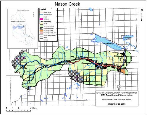
6 Attachment 1 Draft Report XXXXXXXXXXX EES Consulting, Inc. / Yakama Nation Fisheries May 9, 2007 Developed by John Monahan, EES, Inc. in consultation with Bob Rose, Yakama Nation Fisheries. Project Summary. This project consisted of a simple and experimental approach to coordinate various resource personal representing fish and land managers within the Wenatchee subbasin and to use GIS to help identify and gain consensus as to where restoration actions should be implemented. Because the approach was experimental, several contract elements have been slightly modified to accommodate suggestions from resource personnel that helped in the development and final products of this effort. Approximately four coordination meetings were facilitated by the Yakama Nation Fisheries representative (Bob Rose) and John Monahan (EES Consulting). The first two meetings focused upon gaining agreement to the overall project objectives and products. The latter two meetings focused upon development of the GIS products. We began the effort with a focus on Peshastin Creek, and later expanded the effort to Nason Creek and the upper Wenatchee River. The primary objective was to develop a simple GIS product and associated 1-page brochure which could be distributed to various landowners within a specific watershed that would inform them of river and riparian restoration opportunities available on and surrounding their property. A secondary objective was to develop a coordinated data base that would be capable of displaying GIS information at multiple scales (broad and general to specific and very high resolution). This second objective was problematic due to time constraints for the level of funding allocated to this project. Identification of key limiting factors for salmonids and current resources from which this is documented. Identification of Key Limiting Factors was developed during the NPCC 2004 Subbasin Plans and the 2006 Upper Columbia Salmon Recovery Plan. Limiting Factors for the three focus watersheds are listed below: Peshastin Creek Nason Creek Upper Wenatchee River In-channel Characteristics Ecologic Community In-channel Characteristics Passage / Entrainment In-channel Characteristics Passage /Entrainment Water Quantity Flow Passage / Entrainment Water Quality - Temperature Water Quality - Temperature In-channel Characteristics Ecologic Community Maps of area indicating where limiting factors primarily exist and indicating causal agents. All GIS products were made available by GIS Consulting under the guidance and direction of the workgroup. Maps were to cover the HUC 5 /6 watershed scale, and be relatively simple and useful for the layperson. Various examples of GIS products were developed, each with mixed results. For
. Below is a list of all files provided by EES Consulting.")

7 the purposes of this contract and project, maps provided were primarily developed as examples, recognizing fully that additional work would need to be accomplished (field surveys and photo interpretation). Below is a list of all files provided by EES Consulting. Associated with these files are ARC-GIS projects that include multiple shp files that can be used at the discretion of the workgroup, thus allowing a high level of customization for each watershed, project types and / or geographic scale that information would be provided.

8 Maps of general or specific landownership with overlay of where appropriate actions can be implemented to resolve limiting factors. The following images represent some of the working / draft products that were made available to the workgroup by EES and YN staff. Again, these products are primarily provided to find consensus what type of information we would want to approach landowners with to best describe restoration opportunities within their property boundaries. Although not yet developed, we fully anticipate using much higher resolution imagery to more narrowly focus on specific parcels or stream reaches.

9

10
11 List of appropriate actions and associated appropriate funding sources. Actions have been identified for each of the three focal watersheds. These actions come primarily from the Upper Columbia Salmon Recovery Plan Implementation Schedule. Since the Upper Columbia Salmon Recovery Board is in the process of funding coordination, the workgroup decided that coordination and identification of funding should be deferred until a later time. Nason Creek Peshastin Creek Upper Wenatchee River Add nutrients using hatchery carcasses and/or carcass analogs Detailed lower river restoration evaluation and action plan in Nason Culvert Replacement Develop side-channel habitat (from CMZ). Campground and Road Management: Evaluate campground relationship to effects on river/floodplain function. Large wood structures Focus riparian plantings in floodplain areas, residential developments and sidechannel developments Increase pools quality and quantity Move Highway 207 where adjacent to Nason Creek. (CMZ) Restore In-channel condition Restore Passage Evaluate mining effects to riparian and stream channel structure Evaluate National Forests road effects to riparian and stream channel structure (USFS) Increase irrigation delivery and on-site efficiencies Install Pool forming In-Channel Structures Install stream structures to increase thalwag depth (duplicate to in-channel). Remove old earth dikes, canary reed grass, reestablish channel's) and native vegetation. Replace culverts at Skinny Creek Restore passage within Beaver Creek prioritized Riparian plantings for bank stabilization River Road Modification / Relocation Side/Off channel reconnections and restoration UPA Nason Creek Oxbow Reconnection Project Add nutrients using hatchery carcasses and/or carcass analogs Irrigation Efficiency and passage Culvert Replacement Develop side-channel habitat (from CMZ). Remove old earth dikes, canary reed grass, reestablish channel's) and native vegetation. Replace culverts at Skinny Creek Restore passage within Beaver Creek prioritized Riparian plantings for bank stabilization River Road Modification / Relocation Statements of agency support. Statements of agency support were not acquired for this project. The Upper Columbia Salmon Recovery Board is in the beginning stages of developing Implementation Teams Recommended strategy for Phase 2-3 including but not limited to identification of early implementation actions and those requiring greater complexity and time to design, strategy for public contact and materials for presentation. The workgroup agreed that Phase 2 of this project would focus on the development of a series of brochures, one for each watershed within the Wenatchee Subbasin, that would convey the interest identified by various recovery planning efforts and identify the opportunities for landowners to be involved. An example of this brochure was developed and is illustrated below.

12


13
14 Phase 3 of the Project would be the development of a database sufficient with enough detail of stream and riparian characteristics that resource managers can track and illustrate project development at very high geographic resolution. Because LIDAR and new, high resolution ortho images were to be procured over the near future, it was decided this work would not commence until these basic products were available and GIS data clipped and included into the various watershed GIS ARC Project provided by EES Consulting. In addition to this work, Yakama Nation Fisheries in coordination with the Upper Columbia Regional Technical Team has refined the Upper Columbia Biologic Strategy such that relatively site specific restoration and enhancement projects have been prioritized at the watershed scale. This work, alongside of the GIS products discussed above now puts the Wenatchee subbasin in a good position to develop restoration strategies in a coordinated manner with both resource agencies and land owners. End of report.
October 28, SUBJECT: Quarterly Review of Within-year Project Funding Adjustments for Implementation.
 Bruce A. Measure Chair Montana Rhonda Whiting Montana W. Bill Booth Idaho James A. Yost Idaho Dick Wallace Vice-Chair Washington Tom Karier Washington Melinda S. Eden Oregon Joan M. Dukes Oregon October
January 4, Funding recommendation for FY 2008 and a portion of FY 2009 for regional coordination project proposals.
 Tom Karier Chair Washington Frank L. Cassidy Jr. Larry Washington James A. Yost Idaho W. Bill Booth Idaho Joan M. Dukes Vice-Chair Oregon Melinda S. Eden Oregon Bruce A. Measure Montana Rhonda Whiting
Responses to ISRP Preliminary Comments and Recommendations
 Responses to ISRP Preliminary Comments and Recommendations Program: Conservation Enforcement Project ID: #35052 Title : Conservation Enforcement to Enhance and Restore Fish & Wildlife Resources of the
Thurston County, WA Flood Hazard Mitigation Plan Annual Progress Report CRS Activity 510
 Thurston County, WA Flood Hazard Mitigation Plan Annual Progress Report CRS Activity 510 Reporting Period: ctober 1, 2014 to September 30, 2015 Background: Thurston County developed a flood hazard mitigation
Request for Proposal (RFP) Salmon Reintroduction Plan Klamath Tribes Natural Resources Department RFP # 04-KTNRRS16
 Salmon Reintroduction Plan Klamath Tribes Natural Resources Department RFP # 04-KTNRRS16") Introduction: Request for Proposal (RFP) Salmon Reintroduction Plan Klamath Tribes Natural Resources Department RFP # 04-KTNRRS16 The Aquatics Resources Program of the Klamath Tribes Natural Resources
Introduction: Request for Proposal (RFP) Salmon Reintroduction Plan Klamath Tribes Natural Resources Department RFP # 04-KTNRRS16 The Aquatics Resources Program of the Klamath Tribes Natural Resources
In-Lieu Fee Program Instrument Outline For Proposed In-Lieu Fee Programs in the States of Kansas and Missouri
 In-Lieu Fee Program Instrument Outline For Proposed In-Lieu Fee Programs in the States of Kansas and Missouri The U.S. Army Corps of Engineers (Corps) and U.S. Environmental Protection Agency joint regulation
Attachment B. King County Flood Control Zone District Work Program
 Attachment B King County Flood Control Zone District Work Program The King County Flood Control Zone District work program is comprised of two major categories: Programmatic Work Program o Flood Preparedness,
Mission, core values and strategic goals statement
 Fiscal Year 2020 and 2019 Revisions Mission, core values and strategic goals statement Mission To ensure, with public participation, an affordable and reliable energy system while enhancing fish and wildlife
Interagency Regulatory Guide
 Interagency Regulatory Guide Advance Permittee-Responsible Mitigation U.S. Army Corps of Engineers Washington State Department of Ecology Washington State Department of Fish and Wildlife US Army Corps
KITTITAS COUNTY CONSERVATION DISTRICT KITTITAS COUNTY, WASHINGTON RESOLUTION NO
 KITTITAS COUNTY CONSERVATION DISTRICT KITTITAS COUNTY, WASHINGTON RESOLUTION NO. 2016-002 Kittitas County Conservation District A RESOLUTION of the Board of Supervisors of Kittitas County Conservation
RESOLUTION - APPROVING FINAL FISCAL YEAR BUDGET
 ITEM 12 TO: FROM: SUBJECT: Sacramento Area Flood Control Agency Board of Directors Richard M. Johnson, Executive Director (916) 874-7606 RESOLUTION - APPROVING FINAL FISCAL YEAR 2015-16 BUDGET OVERVIEW:
Kentucky Risk MAP It s not Map Mod II
 Kentucky Risk MAP It s not Map Mod II Risk Mapping Assessment and Planning Carey Johnson Kentucky Division of Water carey.johnson@ky.gov What is Risk MAP? Risk Mapping, Assessment, and Planning (Risk MAP)
Anadromous Fish Agreement and Habitat Conservation Plan
 Anadromous Fish Agreement and Habitat Conservation Plan Rocky Reach Hydroelectric Project FERC License No. 2145 Offered for Signing March 26, 2002 ROCKY REACH Page i TABLE OF CONTENTS INTRODUCTION...1
Anadromous Fish Agreement and Habitat Conservation Plan. Rock Island Hydroelectric Project FERC License No. 943
 Anadromous Fish Agreement and Habitat Conservation Plan Rock Island Hydroelectric Project FERC License No. 943 Offered for Signing March 26, 2002 ROCK ISLAND Page i TABLE OF CONTENTS INTRODUCTION...1 SECTION
Fish Division Inland Fisheries Program
 Fish Division Inland Fisheries Program 2017-2019 Organization Chart GOVERNOR COMMISSION DIRECTOR DEPUTY DIRECTOR OF FISH & WILDLIFE PROGRAMS DEPUTY DIRECTOR OF ADMINISTRATIVE PROGRAMS FISH DIVISION INLAND
Ron Walter, Chelan County Julie Dagnon on behalf of Craig Vejraska, Okanogan County Mary Hunt, Douglas County
 UCSRB Board Meeting Minutes Thursday, June 17, 2004 9:00 am to 4:00 pm @ City of East Wenatchee Council Chambers 271 Ninth Street NE East Wenatchee, WA 98802 (509) 884-9515 Board Members Present: Paul
Minutes Educational Advisory Committee (EAC) 15 October :00-4:00 pm
 15 October :00-4:00 pm") Minutes Educational Advisory Committee (EAC) 15 October 2018-2:00-4:00 pm In Attendance: Ken Fisher, Forestry Willie Lantz, Agriculture Greg Rouse, Recreation Gary Shafer, Property Owner Bob Sutton, Property
Minutes Educational Advisory Committee (EAC) 15 October 2018-2:00-4:00 pm In Attendance: Ken Fisher, Forestry Willie Lantz, Agriculture Greg Rouse, Recreation Gary Shafer, Property Owner Bob Sutton, Property
Anadromous Fish Agreement and. Habitat Conservation Plan
 EXHIBIT NO. 1 Anadromous Fish Agreement and Habitat Conservation Plan The Wells Hydroelectric Project FERC License No. 2149 March 26, 2002 TABLE OF CONTENTS INTRODUCTION... 1 SECTION 1 TERM OF AGREEMENT...
Fish Division Inland Fisheries Program
 Fish Division Inland Fisheries Program 2017-2019 Organization Chart GOVERNOR COMMISSION DIRECTOR DEPUTY DIRECTOR OF FISH & WILDLIFE PROGRAMS DEPUTY DIRECTOR OF ADMINISTRATIVE PROGRAMS FISH DIVISION INLAND
IRWM Plan Update Quarter 4 Status Report, 2013 Monterey Peninsula, Carmel Bay, and South Monterey Bay Grant Agreement No.
 Invoice No. 8 Quarterly Report (October 1 December 31, 2013) Contents s 1 16, Update the IRWM Plan and Grant Administration...3 Project 1 Canyon Del Rey Master Drainage Plan Update...6 Project 2 Seaside
Sketch Plan Alternatives: Summary of Planning Commission and Board of Supervisors Recommendations
 HUMBOLDT COUNTY GENERAL PLAN UPDATE Sketch Plan Alternatives: Summary of Planning Commission and Board of Supervisors Recommendations September 2004 Prepared by Humboldt County Department of Community
SECTION Watershed Informed Approach to FY 2016 Budget Development
 SECTION 2 This section provides information and guidance regarding three new initiatives by the Civil Works Integration within USACE to make the budget formulation more streamlined, our investments more
Request for Proposals Phase II South Bachelor Island Wetland Reconnection and Habitat Enhancement Project. Proposals are due March 14 th, 2019 by 4pm
 818 Commercial Street, Room 203, Astoria, Oregon 97103, Phone: (503) 325-0435, Fax: (503) 325-0459 Email: crest@columbiaestuary.org, Website: www.columbiaestuary.org Request for Proposals Phase II South
King County Flood Control District 2015 Work Program
 Attachment A 2015 Work Plan 10-24-14 King County Flood Control District 2015 Work Program The District work program is comprised of three categories: district oversight and policy development, operations,
Oregon Department of Fish and Wildlife PROPAGATION Organization Chart COMMISSION DIRECTOR DEPUTY DIRECTOR OF FISH & WILDLIFE PROGRAMS
 PROPAGATION 2011-13 Organization Chart COMMISSION DIRECTOR DEPUTY DIRECTOR OF FISH & WILDLIFE PROGRAMS DEPUTY DIRECTOR OF ADMINISTRATIVE PROGRAMS FISH DIVISION WILDLIFE DIVISION HUMAN RESOURCES DIVISION
Gov's Planning Estimates Project Title Rank Fund Project Requests for State Funds
 This document is made available electronically by the Minnesota Legislative Reference Library as part of an ongoing digital archiving project. http://www.leg.state.mn.us/lrl/lrl.asp Water and Soil Resources
Appendix A. Plan Formulation. Puyallup River Basin Flood Risk Management Feasibility Study
 Appendix A Plan Formulation Puyallup River Basin Flood Risk Management Feasibility Study Department of the Army Seattle District, US Army Corps of Engineers March 2016 This page intentionally left blank
FY 2001 High Priority Project Recommendations
 FY 2001 High Priority Recommendations Prepared for the Northwest Power Planning Council by the Columbia Basin Fish and Wildlife Authority February 1, 2001 FY 2001 High Priority Recommendations Table of
Discovery Report. Cache River Watershed, Alexander, Johnson, Pulaski, and Union Counties, Illinois
 Discovery Report Cache River Watershed, 07140108 Alexander, Johnson, Pulaski, and Union Counties, Illinois 12/21/2012 i Project Area Community List Community Name Alexander County Village of Tamms Johnson
The Economic Impacts of Restoration
 A Research Paper by The Economic Impacts of Restoration Custer and Lemhi Counties, Idaho April 2014 The Economic Impacts of Restoration Custer and Lemhi Counties, Idaho April 2014 PUBLISHED ONLINE: http://headwaterseconomics.org/land/reports/idaho-restoration-impacts
Peer Review Plan. Bastrop Interim Feasibility Study. Lower Colorado River Basin, Texas
 U.S. Army Corps of Engineers Fort Worth District Peer Review Plan Bastrop Interim Feasibility Study Lower Colorado River Basin, Texas September 28, 2007 PEER REVIEW PLAN BASTROP INTERIM FEASIBILITY STUDY
144 FERC 61,209 UNITED STATES OF AMERICA FEDERAL ENERGY REGULATORY COMMISSION ORDER DENYING RECONSIDERATION. (Issued September 19, 2013)
") 144 FERC 61,209 UNITED STATES OF AMERICA FEDERAL ENERGY REGULATORY COMMISSION Before Commissioners: Jon Wellinghoff, Chairman; Philip D. Moeller, John R. Norris, Cheryl A. LaFleur, and Tony Clark. Public
144 FERC 61,209 UNITED STATES OF AMERICA FEDERAL ENERGY REGULATORY COMMISSION Before Commissioners: Jon Wellinghoff, Chairman; Philip D. Moeller, John R. Norris, Cheryl A. LaFleur, and Tony Clark. Public
A Flood of Questions:
 Oregon Law Institute of Lewis & Clark Law School A Flood of Questions: Integrating Floodplain Management and Salmon Conservation Co-sponsored by CRITFC and OLI OLI We raise the Bar Friday, November 7,
Gravel Evaluation and. Enhancement Plan
 Shasta River (a) Spawning (b) Gravel Evaluation and II. Enhancement Plan Request for Proposal January 2009 Issued by the Pacific States Marine Fisheries Commission In Cooperation With the California Department
SAN JOAQUIN RIVER RESTORATION PROGRAM RESTORATION ADMINISTRATOR 2012 ANNUAL REPORT
 SAN JOAQUIN RIVER RESTORATION PROGRAM RESTORATION ADMINISTRATOR 2012 ANNUAL REPORT Cover Photo: Hills Ferry Trap and Haul Activity November 2012 Rod Meade, Restoration Administrator Submitted by: Roderick
Section 1. Status of Restoration Compliance Report
 Section 1 Status of Restoration Compliance Report Chapter 1 Status of Restoration Compliance Report Compliance with State Water Resources Control Board Decision 1631 and Order Nos. 98-05 and 98-07 May
ARTICLE 2 ADMINISTRATIVE PROVISIONS
 WHATCOM COUNTY CRITICAL AREAS ORDINANCE 16.16.200 Authority ARTICLE 2 ADMINISTRATIVE PROVISIONS This Chapter is adopted under the authority of Chapters 36.70 and 36.70A, RCW and Article 11 of the Washington
Fish Passage Banking Pilot Project Mitigation Banking Instrument
 Attachment 4 Fish Passage Banking Pilot Project Mitigation Banking Instrument Points of Contact: Greg Apke Fish Passage Program Coordinator Oregon Department of Fish and Wildlife 4034 Fairview Industrial
A Flood Mitigation Plan for the Non-Tidal N.J. Section of the Delaware River Basin. Warren County Planning Workshop (2 nd Meeting) March 7, 2007
 March 7, 2007") A Flood Mitigation Plan for the Non-Tidal N.J. Section of the Delaware River Basin Warren County Planning Workshop (2 nd Meeting) March 7, 2007 Study Area Participation: Hunterdon: 16 Eligible Municipalities
A Flood Mitigation Plan for the Non-Tidal N.J. Section of the Delaware River Basin Warren County Planning Workshop (2 nd Meeting) March 7, 2007 Study Area Participation: Hunterdon: 16 Eligible Municipalities
Summary Klamath Hydroelectric Settlement Agreement
 Summary Klamath Hydroelectric Settlement Agreement Summary and Status January 7, 2010 PacifiCorp and over 30 federal, state, tribal, county, irrigation, conservation, and fishing organizations have developed
REQUEST FOR PROPOSALS. Ecosystem Restoration and Protection Services
 STATE OF VERMONT AGENCY OF NATURAL RESOURCES DEPARTMENT OF ENVIRONMENTAL CONSERVATION REQUEST FOR PROPOSALS Ecosystem Restoration and Protection Services PROPOSAL INSTRUCTIONS: All proposals must be addressed
NMFS BiOp on FEMA s National Flood Insurance Program (NFIP) DeeAnn Kirkpatrick January 22, 2009
 DeeAnn Kirkpatrick January 22, 2009") NMFS BiOp on FEMA s National Flood Insurance Program (NFIP) DeeAnn Kirkpatrick January 22, 2009 Background Lawsuit - NWF v. FEMA Consultation started with Washington State, later Puget Sound area Species
NMFS BiOp on FEMA s National Flood Insurance Program (NFIP) DeeAnn Kirkpatrick January 22, 2009 Background Lawsuit - NWF v. FEMA Consultation started with Washington State, later Puget Sound area Species
Date of Issue: January 27, 2017 Closing Date & Time: 4:00 PM, March 3, 2017
 Request for Qualifications For Planning Services: Gee Creek Plateau Sub Area Plan City of Ridgefield, Washington Date of Issue: January 27, 2017 Closing Date & Time: 4:00 PM, March 3, 2017 Project Overview:
Summary Draft Klamath Hydroelectric Settlement Agreement
 Summary Draft Klamath Hydroelectric Settlement Agreement Summary and Status September 30, 2009 Klamath River Basin organizations have developed a draft Klamath Hydroelectric Settlement Agreement and sent
June th Month Expenses: (HCSR) RCO: $7, (HCFW) LE: $ (HCB9) BPA: $ July 25, 2017 Meeting notes
 RCO: $7, (HCFW) LE: $ (HCB9) BPA: $ July 25, 2017 Meeting notes") Date: August 22, 2017 Place: Best Western, Dayton WA Format: Regular Meeting started at 6:00 p.m. Board Members Present for Regular Business Meeting: Gary James (CTUIR), Brad Johnson (AC), Brian Shinn
Date: August 22, 2017 Place: Best Western, Dayton WA Format: Regular Meeting started at 6:00 p.m. Board Members Present for Regular Business Meeting: Gary James (CTUIR), Brad Johnson (AC), Brian Shinn
NAPA COUNTY FLOOD CONTROL AND WATER CONSERVATION DISTRICT Board Agenda Letter
 Agenda Date: 6/7/2016 Agenda Placement: 8A Set Time: 1:30 PM PUBLIC HEARING Estimated Report Time: 20 Minutes NAPA COUNTY FLOOD CONTROL AND WATER CONSERVATION DISTRICT Board Agenda Letter TO: FROM: Board
DRAFT AGENDA. Board of Directors Meeting. August 18, ) Welcome, Introductions 5 min. 2) Lamprey Presentation 20 min
 Welcome, Introductions 5 min. 2) Lamprey Presentation 20 min") DRAFT AGENDA Board of Directors Meeting August 18, 2011 1:00 to 2:00 pm Pre-meeting Tour at the Prosser Hatchery, 990 Grande Road, Prosser 2 pm to 4 pm Board Meeting (LOCATION TO BE CONFIRMED) 1) Welcome,
DRAFT AGENDA Board of Directors Meeting August 18, 2011 1:00 to 2:00 pm Pre-meeting Tour at the Prosser Hatchery, 990 Grande Road, Prosser 2 pm to 4 pm Board Meeting (LOCATION TO BE CONFIRMED) 1) Welcome,
RE: Professional services proposal for the Boulder Creek and Jones Creek Watershed Forest Management Plan.
 December 20, 2012 City of Camas Attn: Eric Levison PO Box 1055 Camas, WA 98607 RE: Professional services proposal for the Boulder Creek and Jones Creek Watershed Forest Management Plan. Mr. Levison: Attached
IRWM Plan Update Quarter 1 Status Report, 2014 Monterey Peninsula, Carmel Bay, and South Monterey Bay Grant Agreement No.
 IRWM Plan Update Quarter 1 Status Report, 2014 Monterey Peninsula, Carmel Bay, and South Monterey Bay Grant Agreement No. 4600009436 Invoice No. 9 Quarterly Report (January 1 March 31, 2014) Tasks 1 16,
Fish Division Marine and Columbia River Fisheries Program
 Fish Division Marine and Columbia River Fisheries Program 2015-2017 Organization Chart GOVERNOR COMMISSION DIRECTOR DEPUTY DIRECTOR OF FISH & WILDLIFE PROGRAMS DEPUTY DIRECTOR OF ADMINISTRATIVE PROGRAMS
Marin County Flood Control and Water Conservation District FLOOD CONTROL ZONE 5 ADVISORY BOARD MAY 15, 2014 STAFF REPORT
 FLOOD CONTROL ZONE 5 ADVISORY BOARD MAY 15, 2014 STAFF REPORT Item 1. Approval of Meeting Minutes for February 10, 2014 Recommended Action: Approve minutes. Item 2. Open Time for Items not on the Agenda
3 TREATY TRIBES-ACTION AGENCY AGREEMENT April 4, 2008
 3 TREATY TRIBES-ACTION AGENCY AGREEMENT MEMORANDUM OF AGREEMENT AMONG THE UMATILLA, WARM SPRINGS AND YAKAMA TRIBES, BONNEVILLE POWER ADMINISTRATION, U.S. ARMY CORPS OF ENGINEERS, AND U.S. BUREAU OF RECLAMATION
Scope of Work. Water Resource Management in Mendocino County: Situation Analysis for the Mendocino County Water Agency
 Scope of Work Water Resource Management in Mendocino County: Situation Analysis for the Mendocino County Water Agency John M. Harper, UCCE County Director and Livestock & Natural Resources Advisor David
THE FRESHWATER TRUST TABLE OF CONTENTS INDEPENDENT AUDITOR'S REPORT 1-2. Statements of Financial Position 3
 Audited Financial Statements FOR THE YEARS ENDED December 31, 2013 and 2012 TABLE OF CONTENTS Page INDEPENDENT AUDITOR'S REPORT 1-2 FINANCIAL STATEMENTS Statements of Financial Position 3 Statement of
Water Resources Engineering Division Public Works City of Colorado Springs
 Water Resources Engineering Division Public Works City of Colorado Springs Richard Mulledy, P.E. Division Manager City of Colorado Springs/Pueblo County IGA City of Colorado Springs/Pueblo County IGA $460
Kittitas County Conservation District. Rate Study Report June 2016
 Kittitas County Conservation District Rate Study Report June 2016 Kittitas County Conservation District 2211 W Dolarway Road, Suite 4 Ellensburg WA 98926 T: 509.925.3352 888.546.0825 FCS Group 7525 166
Best Practices. for Incorporating Building Science Guidance into Community Risk MAP Implementation November 2012
 Best Practices for Incorporating Building Science Guidance into Community Risk MAP Implementation November 2012 Federal Emergency Management Agency Department of Homeland Security 500 C Street, SW Washington,
Public Utility District No. 1 of Douglas County
 Washington State Auditor s Office Financial Statements Audit Report Public Utility District No. 1 of Douglas County Audit Period January 1, 2004 through December 31, 2004 Report No. 69824 Issue Date December
Pacific Northwest Region
 United States Department of Agriculture Forest Service Pacific Northwest Region 333 SW First Avenue (97204) PO Box 3623 Portland, OR 97208-3623 503-808-2468 File Code: 1570 Date: March 7, 2007 Harold Shepherd
Puget Sound Floodplains Mapping Project. Presented by CORE GIS March 18, 2011
 Puget Sound Floodplains Mapping Project Presented by CORE GIS March 18, 2011 Acknowledgements This project was conducted for the National Wildlife Federation, with funding from NWF and the Mountaineers
Cook Inlet Aquaculture Association. Strategic Plan
 Cook Inlet Aquaculture Association Strategic Plan 2015 2020 Approved February 21, 2015 1 Contents 1.0 Introduction to the Strategic Plan 3 2.0 Administration - Purposes of the Cook Inlet Aquaculture Association
UNITED STATES DISTRICT COURT DISTRICT OF OREGON. Plaintiffs, Defendant. INTRODUCTION
 Daniel J. Rohlf, OSB 99006 rohlf@lclark.edu Pacific Environmental Advocacy Center 10015 S.W. Terwilliger Blvd. Portland, OR 97219-7768 Telephone: (503) 768-6707 Fax: (503) 768-6642 Andrew M. Hawley, OSB
Scope of Services. 0.3 Project Administration DRG will provide project administration and monthly invoicing.
 Scope of Services Summary Statement The City of Sammamish is seeking consultant assistance from Davey Resource Group (DRG), a division of The Davey Tree Expert Company to provide professional urban forestry
Oklahoma High Water Marks. CTP Community of Practice April 20, 2017
 Oklahoma High Water Marks CTP Community of Practice April 20, 2017 The Rains Came into Region 6 in May 2015 2 Disaster DR-4222 30 Day Rainfall 3 NOAA Rainfall Amounts / Rainfall Frequency 4 The Rains in
PHASE 2 HAZARD IDENTIFICATION AND RISK ASSESSMENT
 Prioritize Hazards PHASE 2 HAZARD IDENTIFICATION AND After you have developed a full list of potential hazards affecting your campus, prioritize them based on their likelihood of occurrence. This step
San Mateo County Resource Conservation District FY 2012 Financial Budget
 San Mateo County Resource Conservation District FY 2012 Financial Budget REVENUE Grant-funded Projects Biochar Field Trials $ 28,383 Fitzgerald Pollution Reduction $ 77,280 Integrated Watershed Restoration
SEP Production Planning: A Framework
 SEP Production Planning: A Framework Salmonid Enhancement Program Fisheries and Oceans Canada Pacific Region November 2012 1 P a g e Table of Contents Introduction... 3 SEP Mandate... 3 1.1 Fish Production
Chapter 5 Floodplain Management
 Chapter 5 Floodplain Management Contents 1.0 Introduction... 1 2.0 Floodplain Management and Regulation... 1 2.1 City Code... 1 2.2 Floodplain Management... 1 2.3 Level of Flood Protection... 2 2.3.1 Standard
Chemung HUC-8 Watershed Project. February 1, 2011
 Chemung HUC-8 Watershed Project Kickoff Bi Fl t NY Big Flats, NY February 1, 2011 Introductions FEMA Region II Alan Springett, Senior Engineer, FEMA Risk Analysis Risk Assessment Lead Robert Schaefer,
DEPARTMENT OF THE ARMY CORPS OF ENGINEERS, NORTHWESTERN DIVISION PO BOX 2870 PORTLAND OR
 DEPARTMENT OF THE ARMY CORPS OF ENGINEERS, NORTHWESTERN DIVISION PO BOX 2870 PORTLAND OR 97208-2870 CENWD-RBT 0 5 DEC 2012 MEMORANDUM FOR Commander, Walla Walla District (CENWW-PM-PPM/Randy Chong) SUBJECT:
Phase 3 WIP Development Guide
 Goal Phase 3 WIP Development Guide The development of a final plan that: 1. Is implementable to achieve the Total Maximum Daily Load (TMDL) nutrient and sediment load reduction allocations for Pennsylvania.
Public Notice. Activity: Fort Worth District Mitigation Banks. Date: January 24, 2019
 Public Notice Number: CESWF-18-MITB Activity: Fort Worth District Mitigation Banks Date: January 24, 2019 Purpose The purpose of this Public Notice is to inform you of mitigation banking guidelines being
COMMON QUESTIONS & ANSWERS CONNECTICUT RESERVE NOMINATION PUBLIC MEETING
 QUESTION: What is the National Estuarine Research Reserve System? ANSWER: The National Estuarine Research Reserve System (https://coast.noaa.gov/nerrs/) is a network of protected areas representative of
Trout Unlimited, Inc. Financial Report September 30, 2015
 Financial Report September 30, 2015 Contents Independent auditor s report 1-2 Financial statements Balance sheets 3 Statements of activities 4 Statements of changes in net assets 5 Statements of cash flows
Lewis River Hydroelectric Projects Settlement Agreement Aquatic Coordination Committee (ACC) Meeting Agenda
 Meeting Agenda") Lewis River Hydroelectric Projects Settlement Agreement Aquatic Coordination Committee (ACC) Meeting Agenda Date & Time: Thursday, August 8, 2013 9:00 a.m. 12:00 p.m. Place: Merwin Hydro Control Center
Lewis River Hydroelectric Projects Settlement Agreement Aquatic Coordination Committee (ACC) Meeting Agenda Date & Time: Thursday, August 8, 2013 9:00 a.m. 12:00 p.m. Place: Merwin Hydro Control Center
Puyallup Shoreline Master Program FINAL, JAN
 CHAPTER 1 INTRODUCTION A. PURPOSE AND INTENT 1. The purposes of this Shoreline Master Program are: a. To guide the future development of shorelines in the City of Puyallup in a positive, effective, and
Pacific Northwest Region. CERTIFIED MAIL RETURN 52 Thurlow Rd. RECEIPT REQUESTED Twisp, WA NUMBER:
 United States Department of Agriculture Forest Service Pacific Northwest Region 333 SW First Avenue PO Box 3623 Portland, OR 97208-3623 503-808-2468 File Code: 1570 Date: February 17, 2012 Mr. Bernard
SFY 2018 (July 1, 2017 to June 30, 2018) Annual Report
 Annual Report") SFY 2018 (July 1, 2017 to June 30, 2018) Annual Report Thurston Regional Planning Council UNIFIED PLANNING WORK PROGRAM Annual Report for second year of TRPC s UPWP State Fiscal Years 2017-2018 (July 1,
SFY 2018 (July 1, 2017 to June 30, 2018) Annual Report Thurston Regional Planning Council UNIFIED PLANNING WORK PROGRAM Annual Report for second year of TRPC s UPWP State Fiscal Years 2017-2018 (July 1,
July 2, Fish and Wildlife Committee Recommendations for Projects in the Wildlife Category Review
 W. Bill Booth Chair Idaho James A. Yost Idaho Tom Karier Washington Dick Wallace Washington Bruce A. Measure Vice-Chair Montana Rhonda Whiting Montana Melinda S. Eden Oregon Joan M. Dukes Oregon July 2,
FY Biennial Budget Request St Louis, South SWCD
 FY 18-19 Biennial Budget Request St Louis, South SWCD Total Requested Biennial State Contribution: $2,861,816.00 BBR ID BBR16-3852 Total Leveraged Funds $782,803.00 Submitted Date 4/15/2016 Total Resource
DEPARTMENT OF THE ARMY OFFICE OF THE CHIEF OF ENGINEERS WASHINGTON, D.C
 .t DEPARTMENT OF THE ARMY OFFICE OF THE CHIEF OF ENGINEERS WASHINGTON, D.C. 20314-1000 REPLY TO A TTENTION OF: CECW-PE (l0-1-7a) 1 3 OCT 199B SUBJECT: Tampa Harbor, Big Bend Channel, Florida THE SECRETARY
LOCAL HAZARD MITIGATION PLAN UPDATE CHECKLIST
 D LOCAL HAZARD MITIGATION PLAN UPDATE CHECKLIST This section of the Plan includes a completed copy of the Local Hazard Mitigation Checklist as provided by the North Carolina Division of Emergency Management.
Snoqualmie Indian Tribe
 For: Independent Third Party Audit Services Issued: Friday, August 31, 2018 Submission deadline: Friday, September 14, 2018, 5:00 PM PDT Deadline for final submission of questions: Monday, September 10,
STORMWATER MANAGEMENT FUND Department of Environmental Services
 Department of Environmental Services Mission: To implement a comprehensive stormwater management program that balances the following goals: 1) to reduce the potential for stormwater threats to public health,
Modernization, FEMA is Recognizing the connection between damage reduction and
 EXECUTIVE SUMMARY Every year, devastating floods impact the Nation by taking lives and damaging homes, businesses, public infrastructure, and other property. This damage could be reduced significantly
Comprehensive Flood Mitigation for 12,000 Properties
 Comprehensive Flood Mitigation for 12,000 Properties Lori Rafferty, PE, CFM, Louisville MSD & Louie Greenwell, GISP, CFM, T&M Associates Association of State Floodplain Managers 2014 State Conference June
CNMS and FOA: A Year in Review. Rick Sacbibit, P.E. Andy Read, CFM FEMA HQ, Risk Analysis Division June 4, 2015
 CNMS and FOA: A Year in Review Rick Sacbibit, P.E. Andy Read, CFM FEMA HQ, Risk Analysis Division June 4, 2015 Overview Current NVUE Status NVUE Cliff Update on CNMS Web Viewer CNMS Guidance Updates FOA
Funding Support for the Chesapeake Bay SAV Aerial Survey: History, Current Shortfall and Long Term Funding Strategy
 Funding Support for the Chesapeake Bay SAV Aerial Survey: History, Current Shortfall and Long Term Funding Strategy The Chesapeake Bay SAV Aerial Survey has been an integral data source to support science
UNITED STATES OF AMERICA BEFORE THE FEDERAL ENERGY REGULATORY COMMISSION
 UNITED STATES OF AMERICA BEFORE THE FEDERAL ENERGY REGULATORY COMMISSION Public Utility District No. 1 ) Project No. 2149 of Douglas County, Washington ) APPLICATON FOR APPROVAL OF THE WELLS ANADROMOUS
MEMORANDUM OF UNDERSTANDING (#0001) Between
 Between") MEMORANDUM OF UNDERSTANDING (#0001) Between Indiana Department of Natural Resources National Park Service, Indiana Dunes National Lakeshore Save the Dunes Conservation Fund Shirley Heinze Land Trust The
MEMORANDUM OF UNDERSTANDING (#0001) Between Indiana Department of Natural Resources National Park Service, Indiana Dunes National Lakeshore Save the Dunes Conservation Fund Shirley Heinze Land Trust The
Presentation Overview
 2006 Northwest Stream Restoration Design Symposium The National Evaluation of the One-Percent (100-Year) Flood Standard and Potential Implications on Stream Restoration Projects Kevin Coulton, P.E., CFM
Request for Quotation Deepwater Horizon
 Request for Quotation Deepwater Horizon Oceanic Fish Restoration Project Independent Contractor to Provide Alternative Fishing Gear and Related Services Requesting Organization: National Fish and Wildlife
FEMA s Flood Map Modernization Preparing for FY09 and Beyond: Integrated Flood Data Update, Risk Assessment, and Mitigation Planning
 FEMA s Flood Map Modernization Preparing for FY09 and Beyond: Integrated Flood Data Update, Risk Assessment, and Mitigation Planning DRAFT CONCEPT PAPER June 1, 2007 Integrated Flood Data Update, Risk
Use of FEMA Non regulatory Flood Risk Products in Planning
 Use of FEMA Non regulatory Flood Risk Products in Planning Georgia Association of Floodplain Managers Annual Conference March 24, 2016 What are the Non regulatory Flood Risk products? Go beyond the basic
FINAL DRAFT CONSISTENCY REVIEW AND RECOMMENDATIONS REPORT
 CHRIS CHRISTIE Governor KIM GUADAGNO Lt. Governor State of New Jersey Highlands Water Protection and Planning Council 100 North Road (Route 513) Chester, New Jersey 07930-2322 (908) 879-6737 (908) 879-4205
King County Flood Control District Flood Risk Reduction Work Program and Accomplishments
 King County Flood Control District Flood Risk Reduction Work Program and Accomplishments Brian Murray Water and Land Resources Division April 26, 2016 Department of Natural Resources and Parks Water and
REQUEST FOR PROPOSALS
 REQUEST FOR PROPOSALS FOR SERVICES of a REGISTERED PROFESSIONAL FORESTER to the PLUMAS COUNTY FIRE SAFE COUNCIL and PLUMAS CORPORATION PC FSC Fuel Hazard Reduction Project Development & Implementation
PICES-MOE PROJECT ON EFFECTS OF MARINE DEBRIS CAUSED BY THE GREAT TSUNAMI OF 2011
 North Pacific Marine Science Organization (PICES) PICES-MOE PROJECT ON EFFECTS OF MARINE DEBRIS CAUSED BY THE GREAT TSUNAMI OF 2011 FINANCIAL REPORT FOR YEAR 2 (April 1, 2015 March 31, 2016) NORTH PACIFIC
Report to: Development Services Committee Date: June 26, 2017
 SUBJECT: New Provincial Plans Release of the 2017 Growth Plan, Greenbelt Plan and Oak Ridges Moraine Conservation Plan PREPARED BY: Policy and Research, Planning and Urban Design REVIEWED BY: Marg Wouters,
THE FRASER BASIN COUNCIL
 THE FRASER BASIN COUNCIL The Fraser Basin Council (FBC) is a non-governmental, not-for-profit organization created in 1997 to advance the social, economic and environmental dimensions of sustainability