CITY COUNCIL AGENDA REPORT
|
|
|
- Margery Gilbert
- 5 years ago
- Views:
Transcription

1 G.2 CITY COUNCIL AGENDA REPORT TYPE OF ITEM: Public Hearing AGENDA ITEM NO.: 2 DATE: February 5, 2019 TO: FROM: SUBJECT: City Council Ashley Golden Development Services Director Planning and Zoning Permit No (Specific Plan Amendment) - Request for a Text Amendment to the RiverPark Specific Plan Sign Standards to Allow the Future Construction of Two Monument Signs in Planning Districts B and C. Filed by Ann Walsh of Shea Properties, 2751 Park View Court, Suite 261 Oxnard, CA (15/15/10) CONTACT: Ashley Golden, Development Services Director Ashley.Golden@oxnard.org, (805) RECOMMENDATION: That the City Council approve the first reading by title only and waive further reading of an ordinance amending the RiverPark Specific Plan as a result of PZ No (Specific Plan Amendment). BACKGROUND Approval of a Specific Plan Amendment (SPA) is requested to amend the sign standards of the RiverPark Specific Plan (RPSP) to permit the future construction of two (2) Monument Signs in Districts B and C, which are considered Commercial Districts. The subject property is located within Planning Districts B and C in the RPSP, south of Town Center Drive, between North Ventura Road and North Oxnard Boulevard, in an area known as The Landing. Though future commercial development is allowed and anticipated in this area, no development is proposed as part of this application. Furthermore, the construction of the signs is not proposed at this time or directly enabled by the proposed amendment to the RPSP. On December 6, 2018 the Planning Commission approved 5-0, with two Commissioners absent, to recommend that the City Council approve the proposed amendment (see Attachment A - Planning Commission Staff Report). Although there were no public comments on this project at Packet Pg. 35
2 RiverPark Specific Plan Amendment - Signs (15/15/10) February 5, 2019 Page 2 G.2 the Commission meeting, on Dec 5 th a comment letter was submitted from a resident who lives in the RPSP project area (see Attachment B Dec. 5, 2018 comment letter). The commenter expressed general concerns, and stated that he neither opposes nor supports the proposed amendment. ANALYSIS The proposed SPA will modify Section (B), by adding the word Commercial District to the Freeway-Oriented Monument Signs section of the RPSP. The intent is to allow monument signs to be installed in Commercial Districts B and C subject to the RPSP Freeway-Oriented Monument sign standards. This proposed amendment will permit the installation of two (2) future monument signs and modify Exhibit 5.HH of the RPSP to depict the general location that these signs to be permitted within Districts B and C of the specific plan area (see Attachment C). These future signs would be located on the southwest corner of Oxnard Boulevard/Town Center Drive and the southeasterly corner of North Ventura Road/Town Center Drive. This amendment will not result in more freeway oriented signs. The SPA does not change the sign size or height already allowed within the RPSP, but does increase the number of Monument Signs permitted within the RPSP. The allowed maximum height of a Monument Sign is 20 feet, with a maximum sign area of 320 square-feet per side. Signs meeting this criteria exist within the The Collection. The SPA does not amend the permit procedures associated with Monument Signs. As already permitted per Sections (B) and (C) of the RPSP, the sign design, content and, illumination, is subject to a Development Design Review Permit (DDR) from the Development Services Director. As part of the DDR process, Community Workshop would be held to present the proposed design to the neighborhood and solicit public input. If this SPA is approved, construction of the signs would require the Applicant to file and obtain approval of a Development Design Review Permit (DDR) from the Development Services Director. The proposed SPA is consistent with the scope and purpose of the RPSP, as the signs will support the future businesses in The Landing commercial corridor and subject to identical design criteria as similar existing signage within The Collection. STRATEGIC PRIORITIES This agenda item indirectly supports the Economic Development strategy. The purpose of the Economic Development strategy is to develop and enhance Oxnard s business climate, promote the City s fiscal health, and support economic growth in a manner consistent with the City s unique character. This item supports the following goals and objectives: Goal 1. Create vibrant and economically sustainable commercial, industrial and retail industries throughout the City. Packet Pg. 36
3 RiverPark Specific Plan Amendment - Signs (15/15/10) February 5, 2019 Page 3 G.2 Goal 2. Enhance business development throughout the City. Objective 2a. Develop a strong citywide economy which attracts investment, increases the tax base, creates employment opportunities, and generates public revenue. FINANCIAL IMPACT Approval of the proposed SPA and the ability of potential tenants to develop additional signage is expected to attract future commercial businesses and potential development interests to The Landing. Through attraction and retention of development projects, additional property and sales tax would be generated. ATTACHMENTS: Attachment A: Planning Commission Staff Report, PZ Attachment B: Comment Letter Dated December 5, 2018 Attachment C: Amendment Text and Exhibit Attachment D: City Council Ordinance (Specific Plan Amendment) Packet Pg. 37
4 G.2.a To: From: Planning Commission Veronica Ortiz-De Anda, Contract Planner Date: December 6, 2018 Subject: Planning & Zoning Permit No (Specific Plan Amendment) Text amendment to the RiverPark Specific Plan to allow Two (2) Monument Signs in Districts B and C to be generally located on the corners of North Ventura Road/Town Center Drive and Oxnard Boulevard/Town Center Drive 1) Recommendation: That the Planning Commission adopt a resolution recommending approval of Planning & Zoning Permit No (Specific Plan Amendment - SPA) to the City Council, subject to certain findings and conditions. 2) Project Description and Applicant: A request to modify the text of Section (B) (Signage Standards) of the RiverPark Specific Plan (RPSP) to allow two (2) monument signs in Planning Districts B and C of the RPSP; and modification to Exhibit 5.HH to depict the future general location of these proposed signs. Construction of the monument signs is not proposed at this time. For purposes of this staff report, the foregoing project description shall be referred to as the Project. Filed by Ann Walsh, designated agent of RiverPark Landing, LLC, the property owner and Applicant. 3) General Plan and Specific Plan Designation: The subject area within the RPSP associated with the proposed amendment is referred to as The Landing commercial corridor generally bounded by North Ventura Road to the West, Town Center Drive to the North, Oxnard Boulevard to the East, and the water detention basin to the South, which lies adjacent to the highway 101. This area located along Town Center Drive between North Ventura Road and Oxnard Boulevard allows for hotels and other commercial land uses. As illustrated on Attachment A, the specific plan designation for these parcels is Commercial Regional (District B) and Commercial Convention Hotel (District C). The General Plan designation is Commercial Regional. 4) Background Information: The Landing, a commercial area within the RPSP is located in Planning Districts B and C. This area comprises a part of the west commercial corridor in the RPSP community and allows for a variety of commercial land uses, such as but not limited to financial institutions, restaurants, offices, and hotels. On October 18, 2018 the Planning Commission recommended approval to the City Council for an application to subdivide a parcel and vacate a portion of the public right-of-way at the corners of North Ventura Road/Town Center Drive and Oxnard Boulevard/Town Center Drive within RPSP. The proposed subdivision Packet Pg. 38
5 G.2.a PZ No (RiverPark SPA-Signs) Hearing Date: December 6, 2018 Page 2 map to create six (6) lots for future commercial land uses and public right-of-way vacation was approved by City Council on November 27, 2018 (See Attachment B). On August 23, 2018, two Marriott multi-story hotels (Springhill Suites and Towne Place Suites) were approved via Development Design Review (DDR) permit by the Development Services Director. Construction of the hotels is expected to begin by the end of the year. Additionally, an assisted living apartment project known as Oakmont Senior Living, also approved via DDR, is currently under construction to the west of the hotel site. In anticipation of the need for signage by the future businesses in this area, the Applicant is requesting to amend the RPSP to allow two (2) monument signs to serve these businesses. 5) Environmental Determination: In accordance with the California Environmental Quality Act (CEQA), an environmental impact report (EIR No ) was prepared to analyze potential impacts associated with the approval and implementation of the RPSP and the anticipated build out of the 701-acre specific plan area. On July 16, 2002, the City Council adopted Resolution No. 12,209, upholding the Planning Commission s decision certifying the final EIR (State Clearinghouse No FEIR), and adopting findings of fact, statement of overriding considerations, and a mitigation monitoring and reporting program. Mitigation measures identified in FEIR No and subsequent relevant amendments were included as conditions of approval. Since certification of FEIR No there have been no substantial changes proposed for the RPSP project, no substantial changes have occurred under which the RPSP project is being undertaken, and no new information of substantial importance to the RPSP project has become available. The proposed RPSP Amendment will allow future consideration of two monument signs that would support existing and future commercial development already permitted by the RPSP. The proposed amendment is not creating substantial changes to the specific plan that brings new information to light causing additional unexamined environmental impacts. As proposed, the RPSP amendment is consistent with the scope of the RPSP. Therefore, an addendum to FEIR No is required per Public Resources Code Section and Sections through of CEQA guidelines. 6) Analysis: a) General Discussion: The Applicant is proposing to amend Section of the signage standards contained in the RPSP to allow two (2) monument signs (see Attachment C) and modify Exhibit 5.HH to depict their respective general location as shown in Attachment D. The signs are intended to serve future establishments which are envisioned to include two hotels, a senior living facility complex, and other office or retail businesses. The subject signs would fall under the same size standards as the freeway-oriented monument signs already in place at The Collection ; no changes are proposed to the maximum height and design provisions for signs with the proposed amendment. These sign standards are outlined in Section (B)(v) of the RPSP, which are as follows: Packet Pg. 39
6 G.2.a PZ No (RiverPark SPA-Signs) Hearing Date: December 6, 2018 Page 3 Maximum Height Size of Sign Structure 20 feet 320 square-feet per side, total area not to exceed 640 square-feet Maximum Actual Sign Area 65% of the sign area of the structure on each side The sign content, illumination, and the review process of the new signs would fall under the same provisions as the freeway-oriented monument signs, specifically Sections (B) and (C). Pursuant to these sections approval of a DDR permit by the Development Services Director would be required at the time an application is filed to the City to construct the signs. Upon submittal of a DDR application staff will review the various architectural, siting, and design considerations associated with the proposed signs. b) General Plan Consistency: When the RPSP was adopted by the City, it was found to comply with the City s General Plan. The City s 2030 General Plan land use designation for Planning Districts B and C of the RPSP is Commercial Regional (CR), which allows a variety of commercial land uses such as offices, restaurants, and other retail sales establishments. The proposed amendment will support these future land uses in this area. Consistency with the 2030 General Plan is defined by the relationship between 2030 General Plan policies and the proposed Project. The three consistency classification levels are: I. Direct applicability to a proposed project or program (full text of the policy and an explanation). II. III. Related or indirect applicability to the proposed project or program (policy title and an explanation for each or groups of related or indirectly related policies). No or distant applicability to the proposed project or program (all policies not listed as level i and ii are assumed to be consistent). POLICY LEVEL POLICY OR TITLE EXPLANATION CD-4.5 II Require that signage in commercial development improve, rather than detract, from the quality of the surrounding neighborhood. The proposed amendment will support signage in new commercial development areas. Upon an application for construction, the two signs will be reviewed for compliance with the RPSP sign standards, which call for functional, attractive signage incorporating a uniformly, high level of design, graphics, continuity, consistency, and maintenance throughout the RPSP area. CD018.1 Attract new businesses Ample signage options attract new businesses and helps promote commercial business Packet Pg. 40
7 G.2.a PZ No (RiverPark SPA-Signs) Hearing Date: December 6, 2018 Page 4 opportunities in the RPSP area, which in turn helps sustain the economic vitality of the City. All others III All policies not listed above No or distant applicability to the proposed project. c) Conformance with RiverPark Specific Plan Standards: The proposed Project was reviewed by the town master planner/architect in accordance with Section of the RPSP and was found to be in conformance with the RPSP. Exhibit 2.J of Section 2.3 of the RPSP designates Planning Districts B and C for commercial land uses and the future monument signs are accessory structures that would support the functions of these uses. The proposed amendment is not changing or intensifying any of the land uses in the RPSP only allowing for future signage in these planning districts. 7) Development Advisory Committee and Community Workshop: The proposed Project was not reviewed by the Development Advisory Committee, because the application involves an amendment to the RPSP, and does not impact other City departments. Should the RPSP amendment be approved, development of the subject signs would be reviewed as a subsequent DDR Permit. A Community Workshop was held on November 19, A total of 1,863 notices were mailed in accordance with the City s mailing requirements. Two persons from the public attended the meeting for this Project, but neither spoke at the meeting. 8) Appeal Procedure: In accordance with Section of the RPSP, the Planning Commission s decision can be appealed to City Council within 18 days following the decision date. Appeal forms may be obtained from the City Clerk and must be submitted with the appropriate appeal fee before the end of the appeal period. Attachments A. Maps (General Plan, and Zoning) B. Aerial Map C. Text Amendment of Section of the RiverPark Specific Plan D. Proposed Exhibit 5.HH of the RiverPark Specific Plan E. Addendum to the RiverPark Specific Plan EIR (Final EIR 00-03) F. Resolution PZ (Specific Plan Amendment) Prepared by: VD Approved by: KM Packet Pg. 41
8 G.2.a Packet Pg. 42
9 G.2.a
10 G.2.a
11 G.2.a
12 G.2.a Packet Pg. 46


13 G.2.a
14 G.2.a Packet Pg. 48
15 G.2.a Packet Pg. 49
16 G.2.a Packet Pg. 50
17 G.2.a August 27, 2002 FREEWA Y ORIENTED SIGN LOCATIONS HH Packet Pg. 51
18 G.2.a Packet Pg. 52
19 G.2.a Addendum No. 11 to Final Environmental Impact Report No RiverPark Specific Plan EIR (SCH ) Specific Plan Amendment for The Landing Monument Signs PZ This document is Addendum No. 11 to the RiverPark Specific Plan Final EIR, certified July 16, This addendum concludes that there are no additional possible significant adverse environmental effects associated with the amendment to Section and modification of Exhibit 5.HH of the RiverPark Specific Plan (PZ No ), which would allow for two (2) monument signs. The specific plan amendment would allow these non-freeway oriented signs within The Landing commercial area in Districts B and C of the RiverPark Specific Plan area. The specific plan already provides definitions, standards, and permit procedures for the subject monument signs. Packet Pg. 53
20 RiverPark Specific Plan Final EIR Addendum No. 12 City of Oxnard December 6, 2018 G.2.a Background The Oxnard City Council certified the Final Environmental Impact Report (EIR) and approved the RiverPark Specific Plan and the related agreements on August 27, Development of RiverPark began in May 2004 and continues to this date. The Specific Plan has been the subject of several minor administrative amendments since its original adoption. Errata documents have been prepared for the Specific Plan to document these approved specific plan amendments and correct minor inconsistencies in the text and graphic exhibits within the Specific Plan as they have been identified during implementation of the project. In addition, there have been minor amendments to the RiverPark Owner Participation Agreement, and other agreements related to the implementation of the RiverPark Project. For each of these modifications of the RiverPark Project, an Addendum to the Final EIR was prepared by the City of Oxnard to comply with the California Environmental Quality Act (CEQA). Addenda to the Final EIR were also prepared to address minor changes to the construction of the project during the land development phase and minor revisions to the mitigation measures for the air quality impacts of the project to reflect changes in the planning of the main commercial area. A summary of each of the previous Addenda is provided below: Addendum 1 August The RiverPark Project, as described and analyzed in the RiverPark Final EIR, included a proposal for temporary dewatering of limited areas during grading activities. This Addendum addressed a minor change to the dewatering plan to include a second location for a dewatering well. Addendum 2 November 2005 The RiverPark Specific Plan, as described and analyzed in the RiverPark Final EIR, included a conceptual grading plan for the entire Specific Plan Area. This conceptual grading plan identified a total of 10 million cubic yards of cut and fill of earth materials on the project site. It was anticipated that the grading operations would be a balanced operation, requiring no import or export of earth materials, based on the soil characteristics identified in the geotechnical report prepared for the project site. During the initial mass grading of the site, it was determined that soil compression was higher than anticipated. In addition, implementation of the mitigation measures identified in the Final EIR required removal and recompaction of soil at depths greater than the conceptual grading plan. As a result, soil needed to be imported to balance grading on the site. This Addendum assessed the environmental effects of importing of up to 600,000 cubic yards of soil. Addendum 3 June 2007 This Addendum addressed an amendment to the Owner Participation Agreement to permit the hotel allowed in District C to be developed in District D on a 5-acre site on the southeast corner of Oxnard Boulevard and Danvers River Street and allow up to 100,000 square feet of retail commercial development on the 12-acre site in Planning District C where the hotel was originally allowed in the Specific Plan. 2 Packet Pg. 54
21 RiverPark Specific Plan Final EIR Addendum No. 12 City of Oxnard December 6, 2018 G.2.a Addendum 4 June 2007 This Addendum addressed minor changes to the mitigation measures for air quality impacts included in the Final EIR to reflect the planning of the retail commercial project, The Collection at RiverPark, planned in Planning Districts B, C, and D as identified in the RiverPark Specific Plan. Addendum 5 November 2007 This Addendum addressed an amendment to the Owner Participation Agreement and an amendment to the Memorandum of Understanding (MOU) between the Oxnard Community Development Commission (CDC) and the applicants related to financing of public infrastructure, parking facilities, and improvements in support of commercial development in RiverPark, including a 500-space parking structure within the primary commercial district, Planning District D, of the RiverPark Specific Plan. Addendum 6 December 2007 This Addendum addressed an amendment to the RiverPark Specific Plan to allow changing the amount of residential development allowed on the remaining land in Planning Area A, the Mixed Use/Office District and Planning Area F, the Vineyards Neighborhood District. Addendum 7 February 2009 This Addendum addressed a minor amendment to the RiverPark Specific Plan to allow a single freeway oriented sign, up to 60 feet in height, in one of three designated locations in the main commercial district, Planning District D. Addendum 8 July 2009 This Addendum evaluated the addition of an administrative office and maintenance facility for the City of Oxnard General Services Department in Planning District E of the RiverPark Specific Plan Area. Addendum 9 January 2010 This Addendum evaluated the impacts of the Ventura Road Utilities Project for the City of Oxnard Public Works Department, which proposed infrastructure improvements under Ventura Road between Gonzales Road and Vineyard Avenue. Addendum 10 March 2011: An amendment to the signage standards in Section of the specific plan allowed three freeway-oriented monument signs up to 20 feet tall, in designated locations within District D of the Specific Plan area. In addition, the specific plan amendment allowed changeable electronic display panels on the pylon sign subject to approval of a Special Use Permit. The locations of these signs are shown on the revised Exhibit 5.HH, which was incorporated into the specific plan. Proposed Addendum 11: The proposed amendment also modifies Section of the specific plan that is referenced in addendum No. 10. It would allow two monument signs, up to 20 feet tall in designated locations in Planning Districts B and C, as shown in exhibit 5.HH, which would be modified to include these new signs. Precise locations and design of the individual signs would be subject to review by the RiverPark Town Planner/Architect and the City of Oxnard, as part of a Development Design Review permit (DDR). Current applicable development and environmental standards such as traffic safety, 3 Packet Pg. 55
22 RiverPark Specific Plan Final EIR Addendum No. 12 City of Oxnard December 6, 2018 G.2.a landscaping and lighting control would be applied to the project. In particular, illumination and orientation of the signs would be carefully evaluated during review of the DDR to prevent light from spilling onto the adjacent roads and adjacent land uses. The revised specific plan text and the exhibit showing the location of the two signs is attached to this addendum. Project Environmental Review Section of the State California Environmental Quality Act (CEQA) Guidelines states that an addendum to a previously adopted EIR is the appropriate environmental document in instances when no conditions exist that would trigger a subsequent EIR. Three tests determine if a subsequent EIR is required (Section 15162(a)). They are: 1. Substantial changes are proposed in the project which will require major revisions of the previous EIR or negative declaration due to the involvement of new significant environmental effects or a substantial increase in the severity of previously identified significant effects; 2. Substantial changes occur with respect to the circumstances under which the project is undertaken which will require major revisions of the previous EIR or negative declaration due to the involvement of new significant environmental effects or a substantial increase in the severity of previously identified significant effects; 3. New information of substantial importance, which was not known and could not have been known with the exercise of reasonable diligence at the time the previous EIR was certified as complete or the negative declaration was adopted, shows any of the following: a. The project will have one or more significant effects not discussed in the previous EIR or negative declaration, b. Significant effects previously examined will be substantially more severe than previously than in the previous EIR, c. Mitigation measures or alternatives previously found not to be feasible would in fact be feasible and would substantially reduce one or more significant effects of the project, but the project proponents decline to adopt the mitigation measure or alternative, or d. Mitigation measures or alternatives which are considerably different from those analyzed in the previous EIR would substantially reduce one or more significant effects on the environment, but the project proponents decline to adopt the mitigation measure or alternative. In the first test, the signs are accessory structures to a commercial area which was examined by the EIR as part of the project description. The signs do not change the land use type or intensity on the site from the uses and intensity described in the specific plan and therefore will not result in effects not previously discussed. The only potential environmental effect related to this project would be aesthetics (i.e. visual impacts). The Aesthetics section in the RiverPark Specific Plan Final EIR determined that no unavoidable significant impacts to the visual character would result from the RiverPark project, since the development of RiverPark would not obstruct long range views of the 4 Packet Pg. 56
23 RiverPark Specific Plan Final EIR Addendum No. 12 City of Oxnard December 6, 2018 G.2.a mountains and hills in the Los Padres National Forest to the north from the Ventura Freeway and Vineyard Avenue. In addition, the height and character of the commercial development was determined to be consistent with existing development in the area. The proposed signs do not represent a change or increase in land use type or intensity. In addition, the proposed signs would also not block long range views identified above, and the signs will be subject to design review and a Design Development Review permit (DDR). The proposed monument signs would be subject to the same design and size standards as the monument signs already built and located next to the freeway that were examined in Addendum No. 10. In addition, the text amended by the specific plan amendment requires the decision-makers to make the finding that the proposed signs will not be detrimental to (a) the public health, safety or general welfare; or (b) adjacent uses, buildings or structures in the vicinity. Therefore, the proposed amendment would not create additional environmental impacts. In the second test, staff determined that circumstances surrounding the project have not substantially changed with regard to issues, facts, and mitigations included in the RiverPark Specific Plan FEIR. The project buildout has not changed from that evaluated by the Final EIR, nor have the environmental conditions adjacent to the project site. The commercial area is currently under construction as foreseen in the specific plan, and the proposed signs do not change the intensity or land use of the center. In the third test, staff determined that no new information of substantial importance that was not known or could not have been known at the time of the RiverPark Specific Plan Final EIR certification shows that the project will have effects not previously discussed, that significant effects previously examined will be substantially more severe than previously estimated, that mitigation measures previously found infeasible would now be feasible and would substantially reduce effects of the project, and/or that different mitigation measures would substantially reduce effects. The Final Environmental Impact Report with comments and responses and record of project approval may be examined at the City of Oxnard, Planning Division, 214 South C Street, Oxnard, California Please call (805) to arrange a time to review the file. Kathleen Mallory, AICP, LEED Green Associate, MA Planning Division Manager Date 5 Packet Pg. 57

24 G.2.a Packet Pg. 58
25 G.2.a August 27, 2002 FREEWA Y ORIENTED SIGN LOCATIONS HH Packet Pg. 59
26 G.2.a Packet Pg. 60
27 G.2.a RESOLUTION NO. [ ] A RESOLUTION OF THE PLANNING COMMISSION OF THE CITY OF OXNARD RECOMMENDING THAT CITY COUNCIL ADOPT AN ORDINANCE APPROVING PLANNING AND ZONING PERMIT NO (SPECIFIC PLAN AMENDMENT) REVISING THE TEXT OF THE RIVERPARK SPECIFIC PLAN TO AMEND THE PROVISIONS OF SECTION (B) RELATED TO SIGNS, AND REVISING EXHIBIT 5.HH TO SHOW GENERAL LOCATIONS OF THE SUBJECT MONUMENT SIGNS, WITHIN SPECIFIC PLAN DISTRICTS B AND C. FILED BY ANN WALSH DESIGNATED AGENT OF RIVERPARK LANDING, LLC, 2751 PARK VIEW COURT SUITE 261, OXNARD, CA WHEREAS, the Planning Commission of the City of Oxnard has considered the proposed amendment to Section 5 of the RiverPark Specific Plan relating to development standards for monument signs in the specific plan area; and WHEREAS, the Planning Commission has considered the certified environmental impact report for the RiverPark Specific Plan Project (EIR No ) and an Addendum to EIR No for the proposed RiverPark Specific Plan amendment, and has determined that there is no substantial evidence that the specific plan amendment may have a significant effect on the environment because, the proposed project is consistent with the EIR, does not change the use or intensity of land uses on the site since proposed signs are accessory structures to the commercial land uses in this area that were evaluated by the EIR and no additional environmental impacts will be caused by the proposed specific plan amendment and its implementation; and WHEREAS, the Planning Commission finds, after due study, deliberation and public hearing, that the project is a refinement of the RiverPark Specific Plan; that the proposed specific plan amendment conforms with adopted City standards, is in conformance with the General Plan, constitutes good City planning; and that the project will not adversely affect or be materially detrimental to adjacent land uses, buildings or structures or to the public health, safety or general welfare. NOW, THEREFORE, BE IT RESOLVED that the Planning Commission of the City of Oxnard recommends to the City Council the approval of Planning and Zoning Permit No (Specific Plan Amendment), to amend the RiverPark Specific Plan by changing the following section, to read: Packet Pg. 61
28 G.2.a Resolution No. XXXX PZ (RPSP Amendment The Landing Signs) Page 2 Part 1: Section (B) of Section Freeway-Oriented Pole Signs shall be modified to read as follows: Freeway-Oriented Signs B. Commercial Districts and Freeway-Oriented Monument Signs. (i) Number of Signs: Up to three (3) two-sided, freeway-oriented Monument Signs are allowed in Planning District D and up to two (2) commercial district monument signs in District B and C. The final design and location of the Monument Signs shall be subject to approval of a Design Development Review Permit, as provided in Part C of this Section. (ii) Sign Locations: The Monument Signs shall be located within Planning District B, C, and D in the approximate locations shown on Exhibit 5.HH or in other locations along the freeway within Planning District D, subject to approval of a Design Development Review Permit. The Monument Signs shall be approximately evenly spaced. (iii) Sign Content: Monument Signs may include text, graphics and/or logos identifying the shopping center located in Planning District D, and names, brands, and/or logos of tenants operating within the shopping center located in Planning District D. In no event shall product prices be displayed on the Monument Signs. (iii) Illumination: The Monument Signs shall be illuminated with internal illumination. Other type(s) of illumination may be approved as part of a Design Development Review Permit. (iv) Size: (1) Height: Overall height not to exceed twenty (20) feet. (2) Size of Sign Structure: The dimensions of each Monument Sign structure (overall height multiplied by width) shall not exceed three hundred twenty (320) square feet per side, for a total structural area of six hundred forty (640) square feet. (3) Sign Area: In no event shall the total area devoted to tenant and shopping center identification sign area on each side of each Monument Sign exceed sixty-five percent (65%) of the structural area of the Monument Sign. Part 2: Exhibit 5.HH (Exhibit A of this resolution) shall be revised and incorporated into the Specific Plan to show the locations of the monument signs described in Part 1 of this resolution. Packet Pg. 62
29 G.2.a Resolution No. XXXX PZ (RPSP Amendment The Landing Signs) Page 3 PASSED and ADOPTED by the Planning Commission of the City of Oxnard on this 6th day of December, 2018, by the following vote: AYES: NOES: Commissioners: Commissioners: ABSENT: Commissioners: Vincent Stewart, Chair ATTEST: Kathleen Mallory, Secretary Packet Pg. 63
30 G.2.a August 27, 2002 FREEWA Y ORIENTED SIGN LOCATIONS HH Packet Pg. 64
31 G.2.b To: Wilfredo Chua Orlando Dozier Deirdre Frank Jim Fuhring Stephen Huber Rober V. Sanchez Vincent Stewart Date: Thursday, December 5, 2018 Attn: Oxnard Planning Commission Subject: Agenda Item No. 2, PZ , Text amendment to the RiverPark Specific Plan Good afternoon Planning Commissioners, I am writing this letter to express concern over proposed changes to the RiverPark Specific Plan as proposed in Planning & Zoning Permit No While I neither support nor oppose the proposed amendment at this time, I find the proposed change to be one that gives me concern as a resident of the RiverPark Neighborhood. The project description submitted by the applicant states it is a request to modify the text of Section (B) (Signage Standards) of the RiverPark Specific Plan (RPSP) to allow two (2) monument signs in Planning Districts B and C of the RPSP; and modification to Exhibit 5.HH to depict the future general location of these proposed signs. My concern stems from the questions (1) what tangible value does this project add to the neighborhood as a whole, (2) are these additional monument signs critical to the success of the nearby uses, and (3) what visual impacts will the additional signs have on the RiverPark residential and commercial areas? Given the commercial uses that are scheduled for addition to the Planning Districts B and C (principally 2 multi-story hotels and an assisted living facility), which will occupy much of the site it is unclear to me why the proposed additional monument signs in Planning Areas B and C would be imperative to the success of the nearby uses. Additionally, I find it concerning that the proposed amendment would extend the line of monuments signs from their current position (Planning District D only) to the entire southwestern border of the neighborhood (Planning Districts B, C, and D). While I will be unable to attend the Planning Commission Hearing scheduled for December 6 th, the applicant will be presenting their project to the RiverPark Neighborhood Council on December 12 th. I appreciate the applicant s willingness to explain the project to local residents and I hope that the timing of the item before the Planning Commission will not preclude the City from receiving resident input on Planning & Zoning Permit No Sincerely, Clay Edward Downing RiverPark Resident and Homeowner Cc: Michelle Ascension, City of Oxnard, City Clerk Carmen Ramirez, City of Oxnard, Mayor Pro Tem / City Council Member for District 2 Packet Pg. 65
32 G.2.c Packet Pg. 66
33 G.2.c Packet Pg. 67
34 G.2.d CITY COUNCIL OF THE CITY OF OXNARD ORDINANCE NO. AN ORDINANCE OF THE CITY COUNCIL OF THE CITY OF OXNARD APPROVING AN AMENDMENT TO THE RIVERPARK SPECIFIC PLAN (PZ NO ) REVISING THE TEXT OF THE RIVERPARK SPECIFIC PLAN SIGN STANDARDS IN SECTION (B) TO ALLOW TWO (2) MONUMENT SIGNS AND REVISING EXHIBIT 5.HH TO SHOW GENERAL LOCATIONS OF SUBJECT MONUMENT SIGNS, FILED BY ANN WALSH OF SHEA PROPERTIES FOR RIVERPARK LANDING, LLC, 2751 PARK VIEW COURT SUITE 261, OXNARD, CA WHEREAS, on August 27, 2002, the City Council of the City of Oxnard (the City ) adopted by ordinance the RiverPark Specific Plan (the Specific Plan ) as the comprehensive planning program to regulate the use of land and govern the orderly development of the RiverPark community; and WHEREAS, the City Council of the City of Oxnard has considered an amendment to the Specific Plan relating to sign standards in the specific plan area (PZ No ); and WHEREAS, in accordance with the California Environmental Quality Act (CEQA), a final environmental impact report (EIR No ) was prepared to analyze potential impacts associated with the approval and the implementation of the Specific Plan and the anticipated build out of the 701-acre specific plan site; and such EIR has been certified for this project, and an addendum thereto has been prepared, and the City Council has considered the final environmental impact report and the addendum before making its decision herein; and WHEREAS, the City Council has carefully reviewed the December 6, 2018 Planning Commission action recommending approval of the specific plan amendment, and the staff report and the addendum; and has determined that there is no substantial evidence that the specific plan amendment may have a significant effect on the environment because the proposed project is consistent with the EIR, does not change the use or intensity of land uses on the site since proposed signs are accessory structures to the commercial land uses in this area that were evaluated by the EIR, and no additional environmental impacts will be caused by the proposed specific plan amendment and its implementation; and WHEREAS, the proposed amendment is in conformance with the 2030 General Plan and other adopted standards of the City of Oxnard; and WHEREAS, the City Council finds, after due study, deliberation and public hearing, that the amendment is a logical refinement of the Specific Plan; that the proposed specific plan amendment conforms with adopted City standards and constitutes good City planning; and that the amendment will not adversely affect or be materially detrimental to adjacent land uses, buildings or structures or to the public health, safety or general welfare. Packet Pg. 68
35 Ordinance No. PZ No Page 2 G.2.d NOW, THEREFORE, the City Council of the City of Oxnard does ordain to approve an amendment to the RiverPark Specific Plan (Planning and Zoning Permit No ) by changing the following section to read as set forth herein: Part 1: Section (B) of Section Freeway-Oriented Pole Signs shall be modified to read as follows: Freeway-Oriented Signs B. Commercial Districts and Freeway-Oriented Monument Signs. (i) Number of Signs: Up to three (3) two-sided, freeway-oriented Monument Signs are allowed in Planning District D and up to two (2) commercial district monument signs in District B and C. The final design and location of the Monument Signs shall be subject to approval of a Design Development Review Permit, as provided in Part C of this Section. (ii) Sign Locations: The Monument Signs shall be located within Planning District B, C, and D in the approximate locations shown on Exhibit 5.HH, subject to approval of a Design Development Review Permit. The Monument Signs shall be approximately evenly spaced. (iii) Sign Content: Monument Signs may include text, graphics and/or logos identifying the shopping center located in Planning Districts B, C, and D, and names, brands, and/or logos of tenants operating within the shopping center located in the respective districts. In no event shall product prices be displayed on the Monument Signs. (iii) Illumination: The Monument Signs shall be illuminated with internal illumination. Other type(s) of illumination may be approved as part of a Design Development Review Permit. (iv) Size: (1) Height: Overall height not to exceed twenty (20) feet. (2) Size of Sign Structure: The dimensions of each Monument Sign structure (overall height multiplied by width) shall not exceed three hundred twenty (320) square feet per side, for a total structural area of six hundred forty (640) square feet. (3) Sign Area: In no event shall the total area devoted to tenant and shopping center identification sign area on each side of each Monument Sign exceed sixty-five percent (65%) of the structural area of the Monument Sign. Part 2: Exhibit 5.HH (Exhibit A of this resolution) shall be revised and incorporated into the Specific Plan to show the locations of the monument signs described in Part 1 of this resolution. Packet Pg. 69
36 Ordinance No. PZ No Page 3 G.2.d Part 3: The City Council shall approve the first reading by title only and waive further reading of an ordinance amending the RiverPark Specific Plan as a result of PZ Permit No (Specific Plan Amendment) and finally adopt on February 19, 2019, to become effective thirty days thereafter. Part 4: Within fifteen days after passage, the City Clerk shall cause this ordinance to be published one time in a newspaper of general circulation within the City. AYES: NOES: ABSENT: Tim Flynn, Mayor Michelle Ascencion, City Clerk APPROVED AS TO FORM: Stephen Fischer, City Attorney Packet Pg. 70
37 Ordinance No. PZ No Page 4 G.2.d Packet Pg. 71


38 RIVERPARK - THE LANDING SPECIFIC PLAN AMENDMENT Ann Walsh, RiverPark Landing, LLC. Kathleen Mallory Planning & Environmental Services Manager February 5, 2019
39 DESCRIPTION RiverPark The Landing Map Amendment to the River Park Specific Plan (RPSP): Change Section of the RPSP to allow two (2) future monument signs. Modify Exhibit 5.HH to generally identify future location of these new signs. No new construction is proposed with this application. Two new monument signs will not be visible from freeway. Sign area, structure size, and sign content to conform to the existing monument signs near the freeway 2


40 ZONING AND GENERAL PLAN RiverPark The Landing 3


41 FUTURE SIGN LOCATIONS Planning Dist rict B Planning Dist rict C 4


42 EXHIBIT 5.HH RiverPark The Landing Signs 5
43 TEXT AMENDMENT RiverPark The Landing Signs Section (B) of the RPSP: Commercial Districts and Freeway-Oriented Monument Signs Addition of word Commercial Districts to Freeway- Oriented Monument Sign section of RPSP. Allows up to two monument signs in Districts B and C. Amends Figure 5HH to identify sign locations. Signs subject to a Design Development Review Permit. Sign Regulations: Up to 20 feet tall Max area of 320 square feet per sign side 6
44 ENVIRONMENTAL ANALYSIS RiverPark The Landing Signs Amendment is consistent with the scope and purpose of the RiverPark Specific Plan. RiverPark EIR No , City Council Adopted Resolution No. 12,209 on July 16, 2002 certifying the final EIR. An addendum to the Environmental Impact Report was prepared. 7
45 COMMUNITY INPUT & PLANNING COMMISSION ACTION 8 RiverPark The Landing Signs Community Workshop was held on November 19, persons signed in for this project but neither spoke. A Riverpark resident expressed concern via , but stated he neither supports nor opposes the project. value and need of the future signs for the success of the future shopping center visual impacts the signs could have December 6, 2018 the Planning Commission considered and voted 5-0, with 2 commissioners absent, to recommend approval to the City Council.
. 9")
46 RECOMMENDATION RiverPark The Landing Signs That the City Council: Approve the first reading by title only and waive further reading of an ordinance amending the RiverPark Specific Plan as a result of Planning and Zoning Permit No (Specific Plan Amendment). 9
")
47 PLANNING & ZONING PERMIT NO TEXT AMENDMENT TO RIVERPARK SPECIFIC PLAN TO ALLOW TWO (2) MONUMENT SIGNS AT THE LANDING IN RIVERPARK
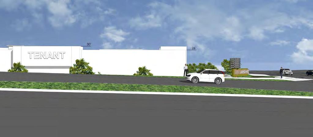
48 PROJECT BENEFITS VALUE TO OXNARD & RIVERPARK As a direct result of the internet, retail leasing has been difficult over the last few years Retailers who are currently willing to talk are also taking less risks in their location choices Freeway visibility is critical in the decision making process, but if that is not an option, visibility from a location with the highest average daily trips will help. Hwy 101 sees 150,000 trips per day while the intersection of Oxnard Blvd / Town Center Drive sees approximately 41,000 trips per day Retail Tenants will be located behind two (2) - four (4) story Hotels and a two (2) level Senior Living Facility, and therefore have no freeway visibility Due to the elevation change at the corner of Oxnard Blvd and Town Center Drive, all but the NE pad will have no visibility from this intersection Tenants touring The Landing see signage on the back of the Esplanade buildings across the street, the Camarillo Outlet Stores and the Kohl s Center in Ventura and want the same Monument signs give The Landing the ability to provide tenants with the visibility, while maintaining design integrity, as we have done at the Collection The main purpose of a Monument Signs is to direct customers to specific businesses. We have a critical need to direct traffic upon exiting HWY 101 at Oxnard Blvd what lane do you need to get into? There is only one block to make that decision.

49 AVERAGE DAILY TRIPS

50 EXISTING & PROPOSED SIGNS ELEVATION ISSUES
51 VIEW STUDY FROM HWY 101 OAKM - - -

52

53

54

55

56

57
58
59 VIEW FROM OXNARD BLVD

60

61

62
63

64
CITY COUNCIL AGENDA REPORT
 M.1 CITY COUNCIL AGENDA REPORT TYPE OF ITEM: Public Hearing AGENDA ITEM NO.: 1 DATE: June 21, 2016 TO: City Council THROUGH: Greg Nyhoff, City Manager Office of the City Manager FROM: SUBJECT: Maria Hurtado,
Planning Commission Staff Report
 Staff Recommendation Planning Commission Staff Report February 5, 2015 Project: Southeast Policy Area, Amendment 1 File: PL0016 and EG-13-030 Request: General Plan Amendment, Community Plan Amendment,
NOVATO GENERAL PLAN 2035 ENVIRONMENTAL IMPACT REPORT CONSULTANT SERVICES AGREEMENT AMENDMENT
 G-3 STAFF REPORT MEETING DATE: September 26, 2017 TO: FROM: City Council Steve Marshall, Planning Manager 922 Machin Avenue Novato, CA 94945 415/ 899-8900 FAX 415/ 899-8213 www.novato.org SUBJECT: NOVATO
CITY OF PALM DESERT COMPREHENSIVE GENERAL PLAN
 Comprehensive General Plan/Administration and Implementation CITY OF PALM DESERT COMPREHENSIVE GENERAL PLAN CHAPTER II ADMINISTRATION AND IMPLEMENTATION This Chapter of the General Plan addresses the administration
Honorable Mayor and Members of the City Council. Elizabeth Corpuz, Director of Planning and Building Services Jason P. Clarke, Senior Planner
 Page 1 of 16 14-L TO: ATTENTION: FROM: SUBJECT: Honorable Mayor and Members of the City Council Jeffrey L. Stewart, City Manager Elizabeth Corpuz, Director of Planning and Building Services Jason P. Clarke,
CITY OF DANA POINT AGENDA REPORT URSULA LUNA-REYNOSA, DIRECTOR OF COMMUNITY DEVELOPMENT
 10/07/14 Page 1 Item #10 CITY OF DANA POINT AGENDA REPORT Reviewed By: DH _X_ CM _X_ CA _X_ DATE: OCTOBER 7, 2014 TO: FROM: CITY MANAGER/CITY COUNCIL URSULA LUNA-REYNOSA, DIRECTOR OF COMMUNITY DEVELOPMENT
Barton Brierley, AICP, Community Development Director (Staff Contact: Tyra Hays, AICP, (707) )
 )") Agenda Item No. 8C May 10, 2016 TO: FROM: SUBJECT: Honorable Mayor and City Council Attention: Laura C. Kuhn, City Manager Barton Brierley, AICP, Community Development Director (Staff Contact: Tyra Hays,
Agenda Item No. 8C May 10, 2016 TO: FROM: SUBJECT: Honorable Mayor and City Council Attention: Laura C. Kuhn, City Manager Barton Brierley, AICP, Community Development Director (Staff Contact: Tyra Hays,
CONSULTANT SERVICES AGREEMENT AMENDMENT NO. 2 WITH RINCON CONSULTANTS FOR WORK ON THE NOVATO GENERAL PLAN 2035 ENVIRONMENTAL IMPACT REPORT
 STAFF REPORT MEETING DATE: January 9, 2018 TO: City Council FROM: Steve Marshall, Planning Manager PRESENTER: N/A 922 Machin Avenue Novato, CA 94945 415/ 899-8900 FAX 415/ 899-8213 www.novato.org SUBJECT:
Planning Commission Staff Report August 18, 2016
 PROPERTY OWNER/APPLICANT: Emerald Park Estates, LLC Mike Motroni (Representative) 2428 Professional Drive #200 Roseville, CA 95661 Staff Recommendation Planning Commission Staff Report August 18, 2016
RESOLUTION WHEREAS, on July 24, 2017 a Scoping Meeting was noticed and held pursuant to CEQA Guidelines Section 15083; and,
 RESOLUTION 2018 A RESOLUTION OF THE OF THE CITY COUNCIL OF THE CITY OF NAPA CITY COUNCIL CERTIFYING THE FINAL ENVIRONMENTAL IMPACT REPORT FOR THE TRINITAS MIXED-USE PROJECT, ADOPTING CERTAIN FINDINGS OF
Zoning Board of Appeals TOWN OF BRUNSWICK 336 Town Office Road Troy, New York 12180
 Zoning Board of Appeals TOWN OF BRUNSWICK 336 Town Office Road Troy, New York 12180 MINUTES OF THE BRUNSWICK ZONING BOARD OF APPEALS MEETING HELD SEPTEMBER 17, 2018 PRESENT were MARTIN STEINBACH, CHAIRMAN,
Section 15085, the City prepared a Notice of Completion of the DEIR that was filed by mail with the State Office of
 ENVIRONMENTAL IMPACT REPORT NO. EIR14-001 A RESOLUTION OF THE CITY COUNCIL OF THE CITY OF BUENA PARK CERTIFYING THE COMPLETION OF A FINAL ENVIRONMENTAL IMPACT REPORT AND RECIRCULATED FINAL ENVIRONMENTAL
WHEREAS, after due notice, the City Planning Commission and the City Council did conduct public hearings on this matter; and,
 ORDINANCE NO. An ordinance authorizing the execution of the development agreement by and between the City of Los Angeles and Sunset Studios Holdings, LLC, a Delaware limited liability company relating
RESOLUTION NO. RESOLUTION OF THE CITY COUNCIL OF THE CITY OF BELMONT AMENDING THE BELMONT VILLAGE SPECIFIC PLAN (BVSP)
") RESOLUTION NO. RESOLUTION OF THE CITY COUNCIL OF THE CITY OF BELMONT AMENDING THE BELMONT VILLAGE SPECIFIC PLAN (BVSP) WHEREAS, on November 14, 2017, the City Council adopted the 2035 General Plan (GP),
RESOLUTION NO. RESOLUTION OF THE CITY COUNCIL OF THE CITY OF BELMONT AMENDING THE BELMONT VILLAGE SPECIFIC PLAN (BVSP) WHEREAS, on November 14, 2017, the City Council adopted the 2035 General Plan (GP),
3. A CITY COUNCIL PUBLIC HEARING FEBRUARY 2, 2015 SUBJECT:
 CITY COUNCIL PUBLIC HEARING SUBJECT: INITIATED BY: FEBRUARY 2, 2015 APPEAL OF THE PLANNING COMMISSION'S DECISION TO APPROVE THE REHABILITATION AND RESTORATION OF A DESIGNATED CULTURAL RESOURCE, DEMOLITION
CHAPTER 1 Introduction
 SECTION 1.1 Introduction CHAPTER 1 Introduction 1.1 INTRODUCTION The subjects of this Environmental Impact Report (EIR) are the proposed Granada Hills Knollwood Community Plan and implementing ordinances
CITY OF VACAVILLE PLANNING COMMISSION Agenda Item No. G.1 STAFF REPORT August 18, 2015 ARROW FOOD AND GAS PUBLIC CONVENIENCE OR NECESSITY (PCN) APPEAL
 APPEAL") CITY OF VACAVILLE PLANNING COMMISSION Agenda Item No. G.1 STAFF REPORT August 18, 2015 Staff Contact: Albert Enault (707 449-5140 TITLE: REQUEST: RECOMMENDATION: ARROW FOOD AND GAS PUBLIC CONVENIENCE OR
CITY OF VACAVILLE PLANNING COMMISSION Agenda Item No. G.1 STAFF REPORT August 18, 2015 Staff Contact: Albert Enault (707 449-5140 TITLE: REQUEST: RECOMMENDATION: ARROW FOOD AND GAS PUBLIC CONVENIENCE OR
1 INTRODUCTION 1.1 PURPOSE
 1 INTRODUCTION 1.1 PURPOSE The County of Mariposa Board of Supervisors proposes to adopt the Mariposa County General Plan. This General Plan will replace the County s current General Plan, which was prepared
MINUTES ADJOURNED PLANNING COMMISSION MEETING JANUARY 9, 2017
 MINUTES ADJOURNED PLANNING COMMISSION MEETING JANUARY 9, 2017 A adjourned meeting of the Planning Commission of the City of Rolling Hills Estates was called to order at 7:00 p.m. in the City Hall Council
COUNCIL ACTION FORM Meeting Date: June 11, 2015 Staff Contact: Fred Sherman, City Clerk
 COUNCIL ACTION FORM Meeting Date: June 11, 2015 Staff Contact: Fred Sherman, City Clerk Agenda Item: Consider passing an ordinance to approve a special use permit request (SUP- 2015-03 to allow for the
June 24, Lely Resort (PUD) Insubstantial Change (PDI) PL Dear Ms. Beasley:
 Insubstantial Change (PDI) PL Dear Ms. Beasley:") June 24, 2016 Ms. Rachel Beasley Zoning & Land Development Review Department Community Development & Environmental Services 2800 North Horseshoe Drive Naples, Florida 34104 RE: Lely Resort (PUD) Insubstantial
June 24, 2016 Ms. Rachel Beasley Zoning & Land Development Review Department Community Development & Environmental Services 2800 North Horseshoe Drive Naples, Florida 34104 RE: Lely Resort (PUD) Insubstantial
Zoning Board of Appeals TOWN OF BRUNSWICK 336 Town Office Road Troy, New York 12180
 Zoning Board of Appeals TOWN OF BRUNSWICK 336 Town Office Road Troy, New York 12180 MINUTES OF THE BRUNSWICK ZONING BOARD OF APPEALS MEETING HELD JANUARY 28, 2019 PRESENT were MARTIN STEINBACH, CHAIRMAN,
GARDEN GROVE PLANNING COMMISSION B Room, Community Meeting Center Stanford Avenue, Garden Grove, CA 92840
 CALL TO ORDER: 7:00 p.m. ROLL CALL: GARDEN GROVE PLANNING COMMISSION B Room, Community Meeting Center 11300 Stanford Avenue, Garden Grove, CA 92840 Chair O Neill Vice Chair Kanzler Commissioner Barker
OFFICE OF HISTORIC RESOURCES City Hall 200 N. Spring Street, Room 559 Los Angeles, CA 90012
 City Hall 200 N. Spring Street, Room 559 Los Angeles, CA 90012 February 2, 2015 TO: Jose Huizar, Chair Planning and Land Use Management Committee FROM: Ken Bernstein, AICP Manager, Office of Historic Resources
DEPARTMENT OF DEVELOPMENT SERVICES BOARD OF ADJUSTMENT BRIEFING July 19, 2017 Agenda Item C.3
 DEPARTMENT OF DEVELOPMENT SERVICES BOARD OF ADJUSTMENT BRIEFING July 19, 2017 Agenda Item C.3 REQUEST: A request for two variances to Cocoa Beach Land Development Code Section 5-05.D to allow two wall
RESOLUTION NO
 PO Qf sup, a1to~.' un`y` : RESOLUTION NO. 265-2006 OF THE BOARD OF SUPERVISORS OF THE COUNTY OF EL DORADO CERTIFYING THE TRAFFIC IMPACT MITIGATION FEE PROGRAM SUPPLEMENT TO THE 2004 GENERAL PLAN ENVIRONMENTAL
REQUEST FOR QUALIFICATIONS (RFQ) Central Valley Opportunity Center Winton Vocational Training Center Project Proposals Due: February 21, 2014
 Central Valley Opportunity Center Winton Vocational Training Center Project Proposals Due: February 21, 2014") REQUEST FOR QUALIFICATIONS (RFQ) Central Valley Opportunity Center Winton Vocational Training Center Project Proposals Due: February 21, 2014 The Central Valley Opportunity Center ( CVOC ) is soliciting
REQUEST FOR QUALIFICATIONS (RFQ) Central Valley Opportunity Center Winton Vocational Training Center Project Proposals Due: February 21, 2014 The Central Valley Opportunity Center ( CVOC ) is soliciting
ORDINANCE NO
 Introduced: March 17, 2015 Passed: March 17, 2015 Published: March 20, 2015 ORDINANCE NO. 2015-8 AN ORDINANCE AUTHORIZING THE CREATION OF THE MALL COMMUNITY IMPROVEMENT DISTRICT IN THE CITY OF HUTCHINSON,
CITY COUNCIL AGENDA REPORT
 L.3 CITY COUNCIL AGENDA REPORT TYPE OF ITEM: Report AGENDA ITEM NO.: 3 DATE: March 19, 2019 TO: FROM: SUBJECT: City Council Steve Naveau Director of Human Resources Successor Memoranda of Understanding
J v` 460t* Assistant Town Manager /Director of Commun ty LAUREL R. PREVETTIL GREG LARSON, TOWN MANAGER MEETING DATE: 09/ 02/ 14.
 t wx f MEETING DATE: 09/ 02/ 14 ITEM NO: Vrlr SOS c " tos COUNCIL AGENDA REPORT DATE: AUGUST 27, 2014 TO: A+ p J v` 460t* FROM: GREG LARSON, TOWN MANAGER SUBJECT: NORTH FORTY SPECIFIC PLAN GENERAL PLAN
MEMORANDUM DEBORAH MALICOAT, DIRECTOR OF ADMINISTRATIVE SERVICES
 MEMORANDUM TO: FROM: BY: CITY COUNCIL DEBORAH MALICOAT, DIRECTOR OF ADMINISTRATIVE SERVICES KAREN SISKO, HUMAN RESOURCES MANAGER SUBJECT: RESOLUTION OF INTENTION AND INTRODUCTION OF ORDINANCE TO APPROVE
CHAPTER 1 INTRODUCTION
 CHAPTER 1 INTRODUCTION 1.1 PROJECT BACKGROUND This Environmental Impact Report (EIR) examines the potentially significant effects on the environment resulting from the proposed City of Citrus Heights City
Zoning Board of Appeals TOWN OF BRUNSWICK 336 Town Office Road Troy, New York 12180
 Zoning Board of Appeals TOWN OF BRUNSWICK 336 Town Office Road Troy, New York 12180 MINUTES OF THE BRUNSWICK ZONING BOARD OF APPEALS MEETING HELD NOVEMBER 19, 2018 PRESENT were MARTIN STEINBACH, CHAIRMAN,
CITY OF SIGNAL HILL Cherry Avenue Signal Hill, CA 90755
 CITY OF SIGNAL HILL 2175 Cherry Avenue Signal Hill, CA 90755 November 20, 2012 AGENDA ITEM TO: FROM: SUBJECT: HONORABLE MAYOR AND MEMBERS OF THE CITY COUNCIL CHARLIE HONEYCUTT DEPUTY CITY MANAGER INTRODUCTION
CITY OF DEL MAR CITY COUNCIL POLICY BOOK
 PAGES: 1 OF 7 POLICY Pursuant to the State of California Government Code 65450 65457, the City of Del Mar utilizes the Specific Plan process as a means to ensure development complies with the intent and
Truckee Railyard Draft Master Plan EIR. Draft Environmental Impact Report Appendices A-B SCH No
 Truckee Railyard Draft Master Plan EIR Volume 1. Draft Environmental Impact Report Appendices A-B SCH No. 2007122092 Prepared for: Town of Truckee November 2008 TRUCKEE RAILYARD DRAFT MASTER PLAN Volume
Planning Commission Staff Report December 18, 2008
 Planning Commission Staff Report December 18, 2008 Project: Appeal of a Planning Director s Determination for Tintpros of Elk Grove Request: The Applicant is seeking to appeal the Planning Director s denial
FROM: CITY MANAGER DEPARTMENT: PLANNING AND COMMUNITY ENVIRONMENT DATE: SEPTEMBER 11, 2006 CMR: 346:06
 21a TO: HONORABLE CITY COUNCIL FROM: CITY MANAGER DEPARTMENT: PLANNING AND COMMUNITY ENVIRONMENT DATE: SEPTEMBER 11, 2006 CMR: 346:06 SUBJECT: 901 SAN ANTONIO ROAD [06PLN-00031, 06PLN-00050]: REQUEST BY
TOWN OF SOUTHPORT 1139 Pennsylvania Avenue Elmira, NY 14904
 TOWN OF SOUTHPORT 1139 Pennsylvania Avenue Elmira, NY 14904 Minutes Approved by Board of Appeals 9/19/2018 ZONING BOARD OF APPEALS Wednesday, August 15, 2018 7:00 PM PUBLIC HEARING Horvath Communications
Proposed Menlo Gateway Project Development Agreement Term Sheet
 Proposed Menlo Gateway Project Development Agreement Term Sheet Presentation to City Council April 6, 2010 Availability of Final Environmental Impact Report (FEIR) and Fiscal Impact Analysis More Information.
CLEARFIELD PLANNING COMMISSION MEETING February 7, :00 P.M. Regular Session
 CLEARFIELD PLANNING COMMISSION MEETING February 7, 2018 7:00 P.M. Regular Session PRESIDING: Brady Jugler Chair PRESENT: Kathryn Murray Commissioner Robert Browning Commissioner Michael Britton Commissioner
2020 Annual Amendment to the Comprehensive Plan and Land Use Regulatory Code. Monday, April 1, 2019, at 5:00 p.m.
 APPLICATION PACKET 2020 Annual Amendment to the Comprehensive Plan and Land Use Regulatory Code Application Deadline: Monday, April 1, 2019, at 5:00 p.m. Application Fee: $1,400 Submittal Requirements:
BEVERLY HILLS AGENDA REPORT. Honorable Mayor & City Council
 BEVERLY HILLS Meeting Date: February 7, 2017 Item Number: 0 9 To: From: Subject: AGENDA REPORT Honorable Mayor & City Council Attachments: 1. Resolution Ryan Gohlich, AICP, Assistant Director of Community
Planning Commission WORKSHOP: General Plan Implementation Program - Task 2 Refining the General Plan Implementation Checklist.
 6.1 MARIPOSA COUNTY Commission 209-966-5151 MEETING: October 6, 2017 TO: FROM: The Mariposa County Commission Sarah Williams, Director RE: General Plan Implementation Program - Workshop 1 WORKSHOP: General
±25,473 SF New Retail Development in W. Ventura County
 the c ampus at topa towers 2 3 4 0 2 3 5 0 v in e ya r d av e ox n a r d, c a 9 3 0 3 6 ±25,473 SF New Retail Development in W Ventura County US H E E sp l a n a de D 01 wy 1 r E V in e yar d Ave Renderings,,
Community Development Department
 Community Development Department SUBJECT: First consideration of an ordinance for Final Site Plan Review and Preliminary Subdivision for Abt at 1200 Milwaukee Avenue AGENDA ITEM: 11.c MEETING DATE: August
[Business and Tax Regulations, Planning Codes - Central South of Market Housing Sustainability District]
![[Business and Tax Regulations, Planning Codes - Central South of Market Housing Sustainability District]](/thumbs/82/85819222.jpg "[Business and Tax Regulations, Planning Codes - Central South of Market Housing Sustainability District]") FILE NO. ORDINANCE NO. 1 [Business and Tax Regulations, Planning Codes - Central South of Market Housing Sustainability District] Ordinance amending the Business and Tax Regulations and Planning Codes
FILE NO. ORDINANCE NO. 1 [Business and Tax Regulations, Planning Codes - Central South of Market Housing Sustainability District] Ordinance amending the Business and Tax Regulations and Planning Codes
TABLE OF CONTENTS. Project Analysis... A-1 Project Summary Background Issues Conclusion. Findings... F-1 CEQA Findings Charter Findings
 CPC-2008-3470-SP-GPA-ZC-SUD-BL-M3 TABLE OF CONTENTS Project Analysis... A-1 Project Summary Background Issues Conclusion Findings... F-1 CEQA Findings Charter Findings Public Hearing and Communications...
Staff Report. Staff requests Commission review, discussion and determination of a policy on Unincorporated Islands and Corridors
 SONOMA LOCAL AGENCY FORMATION COMMISSION 575 ADMINISTRATION DRIVE, ROOM 104A, SANTA ROSA, CA 95403 (707) 565-2577 FAX (707) 565-3778 www.sonoma-county.org/lafco Staff Report Meeting Date: April 4, 2012
Community Development Department
 Community Development Department SUBJECT: First Consideration of ordinance for vacation of Shermer Road right-of-way at 2400 Lehigh Avenue AGENDA ITEM: 11.a MEETING DATE: May 17, 2016 TO: Village President
REQUEST FOR CITY COUNCIL ACTION
 REQUEST FOR CITY COUNCIL ACTION MEETING DATE: APRIL 26, 2016 TITLE: REDUCTION OF LIEN FOR ASSESSMENT DISTRICT NO. 13-25 (PLANNING AREA 58- EASTWOOD) RECOMMENDED ACTION Adopt - A RESOLUTION OF THE CITY
CITY OF PISMO BEACH Planning Commission Meeting Tuesday, December 9, 2014 DRAFT MINUTES. Chair White, Vice-Chair Hamrick, Jewell, Overland, Woodhouse.
 CITY OF PISMO BEACH Planning Commission Meeting Tuesday, December 9, 2014 DRAFT MINUTES Call to order: 6:30 p.m. 1. Roll Call: Commissioners present: Commissioners absent: Staff present: Chair White, Vice-Chair
SAN FRANCISCO PLANNING DEPARTMENT
 REMARKS Addendum #2 to Environmental Impact Report Addendum Date: June 11, 2015 Case No.: 2011.0558E Project Title: Transit Effectiveness Project, Modified TTRP.5 Moderate Alternative, McAllister Street
Addendum to Environmental Impact Report
 Lead Agency: Staff Contact: Addendum to Environmental Impact Report Addendum Date: Case No.: 2011.0558E Project Title:, EIR: 2011.0558E, certified March 27, 2014 Project Sponsor: Sean Kennedy, San Francisco
REQUEST FOR PROPOSAL TO PREPARE A GENERAL PLAN UPDATE AND AN ENVIRONMENTAL IMPACT REPORT
 REQUEST FOR PROPOSAL TO PREPARE A GENERAL PLAN UPDATE AND AN ENVIRONMENTAL IMPACT REPORT Community Development Department/Planning Division 100 Civic Center Plaza Lompoc CA 93436 Issue Date: July 25, 2007
ORDINANCE NO. CID-3193
 ORDINANCE NO. CID-3193 AN ORDINANCE MAKING FINDINGS AS TO THE NATURE AND ADVISABILITY OF CREATING A COMMUNITY IMPROVEMENT DISTRICT AT THE NORTHWEST CORNER OF 93 RD STREET AND METCALF AVENUE; CREATING SAID
TAX INCREMENTAL PROJECT PLAN
 TAX INCREMENTAL PROJECT PLAN TAX INCREMENT DISTRICT #77 RUSHMORE GATEWAY CORRIDOR CITY OF RAPID CITY Prepared by the Rapid City Community Planning and Development Services Department April 2016 INTRODUCTION
CITY OF PALM DESERT PALM DESERT PLANNING COMMISSION
 CITY OF PALM DESERT PALM DESERT PLANNING COMMISSION TUESDAY, JULY 5, 2016 6:00 P.M. COUNCIL CHAMBER 73-510 FRED WARING DRIVE, PALM DESERT, CA 92260 I. CALL TO ORDER Chair John Greenwood called the meeting
CITY OF SOUTH SAN FRANCISCO GRADING PERMIT APPLICATION CHECKLIST
 CITY OF SOUTH SAN FRANCISCO GRADING PERMIT APPLICATION CHECKLIST Applicant shall provide three (3) copies of the following attachments: Geotechnical Report (Soils Report with grading specifications and
AMADOR COUNTY PLANNING COMMISSION MINUTES SUMMARY MINUTES OF TAPE RECORDED MEETING MAY 13, :00 P.M. PAGE 1 OF 4
 MAY 13, 2014 7:00 P.M. PAGE 1 OF 4 The Planning Commission of the County of Amador met at the County Administration Center, 810 Court Street, Jackson, California. The meeting was called to order at 7:00
Planning Commission 101:
 : The Nuts and Bolts of Planning March 6, 2019 Panelists» David Early, AICP, Senior Advisor, PlaceWorks» Marc Roberts, City Manager, City of Livermore» Bill Anderson, Director of City and Regional Planning,
TAUSSIG DEVELOPMENT IMPACT FEE JUSTIFICATION STUDY CITY OF ESCALON. Public Finance Public Private Partnerships Urban Economics Clean Energy Bonds
 DAVID TAUSSIG & ASSOCIATES, INC. DEVELOPMENT IMPACT FEE JUSTIFICATION STUDY CITY OF ESCALON B. C. SEPTEMBER 12, 2016 Public Finance Public Private Partnerships Urban Economics Clean Energy Bonds Prepared
M I N U T E S GARDEN GROVE PLANNING COMMISSION REGULAR MEETING COMMUNITY MEETING CENTER STANFORD AVENUE JUNE 5, 2003 GARDEN GROVE, CALIFORNIA
 M I N U T E S GARDEN GROVE PLANNING COMMISSION REGULAR MEETING COMMUNITY MEETING CENTER THURSDAY 11300 STANFORD AVENUE JUNE 5, 2003 GARDEN GROVE, CALIFORNIA CALL TO ORDER: The work session of the Planning
ORDINANCE NUMBER 1174
 ORDINANCE NUMBER 1174 AN ORDINANCE OF THE CITY COUNCIL OF THE CITY OF PERRIS, COUNTY OF RIVERSIDE, STATE OF CALIFORNIA, ACTING IN ITS CAPACITY AS THE LEGISLATIVE BODY OF COMMUNITY FACILITIES DISTRICT NO.
AGENDA UPDATE ECONOMIC DEVELOPMENT & FINANCE STANDING COMMITTEE MEETING MONDAY, JULY 6, 2015 III. COMMITTEE AGENDA
 AGENDA UPDATE ECONOMIC DEVELOPMENT & FINANCE STANDING COMMITTEE MEETING MONDAY, JULY 6, 2015 III. COMMITTEE AGENDA NEW ITEM ITEM NO. 3 150179.RESOLUTION: BONNER SPRINGS NRP NO. 5 Synopsis: A resolution
NAPA COUNTY BOARD OF SUPERVISORS Board Agenda Letter
 Agenda Date: 3/22/2016 Agenda Placement: 9B Set Time: 9:15 AM PUBLIC HEARING Estimated Report Time: 6 Hours Continued From: February 9, 2016 NAPA COUNTY BOARD OF SUPERVISORS Board Agenda Letter TO: FROM:
MINUTES OF SPECIAL MEETING ZONING BOARD OF APPEALS TOWN OF CHESTER AUGUST 06, The meeting was called to order by Chairman Grady at 7:00 p.m.
 MINUTES OF SPECIAL MEETING ZONING BOARD OF APPEALS TOWN OF CHESTER AUGUST 06, 2015 The meeting was called to order by Chairman Grady at 7:00 p.m. ATTENDANCE: Chairperson John Grady, Mary Jane Dower, Arnold
CITY OF COLORADO SPRINGS PLANNING COMMISSION RECORD-OF-DECISION
 CITY OF COLORADO SPRINGS PLANNING COMMISSION RECORD-OF-DECISION January 20, 2011 Page 16 NEW BUSINESS CALENDAR MEETING: JANUARY 20, 2011 ITEM: 5 STAFF: FILE NO: PROJECT : BRETT VELTMAN CPC NV 10-00098(RF)
ORDINANCE NO
 FULL TEXT OF MEASURE ORDINANCE NO. 2016-03 AN ORDINANCE OF THE CITY OF ALBANY ENACTING A SPECIAL PARCEL TAX TO FUND REPAIRING AND UPGRADING PUBLIC SIDEWALKS AND REMOVING OBSTRUCTIONS TO IMPROVE SAFETY
Reasonable Modification from the Planning Code
 APPLICATION PACKET Reasonable Modification from the Planning Code SAN FRANCISCO PLANNING DEPARTMENT 1650 MISSION STREET, SUITE 400 SAN FRANCISCO, CA 94103-2479 MAIN: (415) 558-6378 SFPLANNING.ORG Planning
DEVELOPMENT AGREEMENT. between THE CITY OF CARSON. ( City ) and CAM-CARSON, LLC. A Delaware limited liability company.
 and CAM-CARSON, LLC. A Delaware limited liability company.") RECORDING REQUESTED BY, AND WHEN RECORDED MAIL TO: CITY CLERK City of Carson 701 E. Carson Street Carson, CA 90745 Space Above For Recorder s Use Only No Recording Fee Required Government Code 27383 DEVELOPMENT
RECORDING REQUESTED BY, AND WHEN RECORDED MAIL TO: CITY CLERK City of Carson 701 E. Carson Street Carson, CA 90745 Space Above For Recorder s Use Only No Recording Fee Required Government Code 27383 DEVELOPMENT
Village of Lansing Planning Board Meeting February 26, 2013
 Village of Lansing Planning Board Meeting February 26, 2013 1 2 3 4 5 6 7 8 9 10 11 12 13 The meeting of the was called to order at 7:35 P.M. by Chairman Mario Tomei. Present at the meeting were Planning
Richard Pearson, Community Development Director Tim Tucker, City Engineer
 CITY OF MARTINEZ CITY COUNCIL AGENDA February 21, 2007 TO: FROM: PREPARED BY: SUBJECT: Mayor and City Council Don Blubaugh, City Manager Richard Pearson, Community Development Director Tim Tucker, City
CITY OF ROCK ISLAND ORDINANCE NO. O AN ORDINANCE OF THE CITY OF ROCK ISLAND, ROCK ISLAND COUNTY, ILLINOIS, ADOPTING TAX INCREMENT ALLOCATION FI
 CITY OF ROCK ISLAND ORDINANCE NO. O- -2014 AN ORDINANCE OF THE CITY OF ROCK ISLAND, ROCK ISLAND COUNTY, ILLINOIS, ADOPTING TAX INCREMENT ALLOCATION FINANCING FOR THE LOCKS REDEVELOPMENT PROJECT AREA WHEREAS,
The Principal Planner informed the Commission of the following items of interest:
 OFFICIAL CITY OF LOS ANGELES North Valley Area Planning Commission Minutes January 18, 2001 4:30 PM California State University-Northridge - Student Union-Grand Salon Room 18111 Nordhoff Street Northridge,
Honorable Mayor and Members of the City Council through City Manager. Public Hearing to Receive Public Comment, Discuss the Draft Environmental
 Agenda Item # 5.A DATE: May 21, 2018 TO: FROM: SUBJECT: Honorable Mayor and Members of the City Council through City Manager Heather Hines, Planning Manageri Public Hearing to Receive Public Comment, Discuss
ORDINANCE NO Section 1. The City Council finds the above recitals are true and correct and incorporated herein by this reference.
 ORDINANCE NO. 1814 AN ORDINANCE OF THE CITY COUNCIL OF THE CITY OF CARSON, CALIFORNIA, ACTING IN ITS CAPACITY AS THE LEGISLATIVE BODY OF THE CARSON COMMUNITY FACILITIES DISTRICT NO. 2018-01 (MAINTENANCE
RESOLUTION NUMBER 3415
 RESOLUTION NUMBER 3415 A RESOLUTION OF THE CITY COUNCIL OF THE CITY OF PERRIS, ACTING AS THE LEGISLATIVE BODY OF COMMUNITY FACILITIES DISTRICT NO. 2001-3 (NORTH PERRIS PUBLIC SAFETY) OF THE CITY OF PERRIS,
Oakland City Planning Commission
 Oakland City Planning Commission STAFF REPORT Case File Number A04-210 June 2, 2004 Location: 500 Lake Park Avenue (See map on reverse) Assessors Parcel Numbers: 011-0837-086-04 Proposal: An appeal of
CITY COUNCIL OF THE CITY OF NOVATO
 CITY COUNCIL OF THE CITY OF NOVATO ORDINANCE NO. 1590 AN ORDINANCE OF THE CITY COUNCIL OF THE CITY OF NOVATO ESTABLISHING SECTION 7-7 OF CHAPTER VII THE NOVATO MUNICIPAL CODE REGULATING THE USE OF SINGLE
BEFORE THE BOARD OF SUPERVISORS OF NAPA COUNTY
 BEFORE THE BOARD OF SUPERVISORS OF NAPA COUNTY In the Matter of: An Appeal by Eric Titus Lee E. Titus and Sons Vineyard and an appeal filed by Ginny Simms to a decision by the Planning Commission on March
RESOLUTION NUMBER 3305
 RESOLUTION NUMBER 3305 RESOLUTION OF INTENTION OF THE CITY COUNCIL OF THE CITY OF PERRIS TO ESTABLISH COMMUNITY FACILITIES DISTRICT NO. 2004-5 (AMBER OAKS II) OF THE CITY OF PERRIS AND TO AUTHORIZE THE
The Planning Commission met in Regular Session at 7: 03 PM, Wednesday, June 22, 2016, in the Council Chambers, 3191 Katella Avenue;
 MINUTES OF PLANNING COMMISSION MEETING OF THE CITY OF LOS ALAMITOS REGULAR MEETING 1. CALL TO ORDER The Planning Commission met in Regular Session at 7: 03 PM, Wednesday,, in the Council Chambers, 3191
WHEREAS, The revised GMO Guidelines, which implement the requirements of the GMO, are set forth below;
 RESOLUTION 2014-145 ADOPTING REVISED GROWTH MANAGEMENT ORDINANCE GUIDELINES WHEREAS, On June 16, 1987, City Councii adopted by ordinance a Residential Growth Management Plan, (commonly referred to as the
Planning Commission Agenda
 I. CALL TO ORDER II. ROLL CALL Planning Commission Agenda October 24, 2017 6:00 PM, Council Chambers, Independence City Hall City Code Chapter 14 and the staff reports are entered into the record. III.
SUBDIVISION & DEVELOPMENT APPEAL BOARD DECISION
 Subdivision & Development Appeal Board Appeal No.: 0262 004/2016 Hearing Date: November 2, 2016 SUBDIVISION & DEVELOPMENT APPEAL BOARD DECISION CHAIR: V. HIGHAM PANEL MEMBER: K. HOWLEY PANEL MEMBER: P.
LEE COUNTY, FLORIDA DEPARTMENT OF COMMUNITY DEVELOPMENT ZONING DIVISION STAFF REPORT
 LEE COUNTY, FLORIDA DEPARTMENT OF COMMUNITY DEVELOPMENT ZONING DIVISION STAFF REPORT TYPE OF CASE: Variance CASE NUMBER: VAR2010-00010 HEARING EXAMINER DATE: July 14, 2010 I. APPLICATION SUMMARY: A. Applicant:
CITY OF VACAVILLE PLANNING COMMISSION Agenda Item No. G.2 STAFF REPORT September 17, Staff Contact: Albert Enault (707)
") CITY OF VACAVILLE PLANNING COMMISSION Agenda Item No. G.2 STAFF REPORT September 17, 2013 Staff Contact: Albert Enault (707) 449-5140 TITLE: REQUEST: INTERCHANGE BUSINESS PARK POLICY PLAN AMENDMENT (VACA
CITY OF VACAVILLE PLANNING COMMISSION Agenda Item No. G.2 STAFF REPORT September 17, 2013 Staff Contact: Albert Enault (707) 449-5140 TITLE: REQUEST: INTERCHANGE BUSINESS PARK POLICY PLAN AMENDMENT (VACA
LOWELL CHARTER TOWNSHIP PLANNING COMMISSION PUBLIC HEARING AND REGULAR MEETING October 9, 2006
 LOWELL CHARTER TOWNSHIP PLANNING COMMISSION PUBLIC HEARING AND REGULAR MEETING PRESENT: Blumm, Batchelor, Simmonds, Clements and Sanford ABSENT: None TOWNSHIP PLANNER: Tim Johnson CITIZENS IN ATTENDANCE:
TAX INCREMENTAL DISTRICT PROJECT PLAN
 TAX INCREMENTAL DISTRICT PROJECT PLAN PROMISE ROAD CITY OF RAPID CITY Prepared by the Rapid City Community Development Department November 2017 INTRODUCTION Tax Increment Financing is a method of financing
U S E P E R M I T. CITY OF BERKELEY ZONING ORDINANCE Berkeley Municipal Code Title 23 USE PERMIT #
 Planning and Development Department Land Use Planning U S E P E R M I T CITY OF BERKELEY ZONING ORDINANCE Berkeley Municipal Code Title 23 USE PERMIT # 11-10000054 Property Address: Permittee Name: 1407
ORDINANCE NO. AN ORDINANCE OF THE CITY OF BELMONT ADDING CHAPTER 32 (MINIMUM WAGE) TO THE BELMONT CITY CODE
 TO THE BELMONT CITY CODE") ORDINANCE NO. AN ORDINANCE OF THE CITY OF BELMONT ADDING CHAPTER 32 (MINIMUM WAGE) TO THE BELMONT CITY CODE WHEREAS, the State of California has enacted a minimum wage that will reach $15.00 per hour in
ORDINANCE NO. AN ORDINANCE OF THE CITY OF BELMONT ADDING CHAPTER 32 (MINIMUM WAGE) TO THE BELMONT CITY CODE WHEREAS, the State of California has enacted a minimum wage that will reach $15.00 per hour in
Staff Report City of Manhattan Beach
 Agenda Item #: Staff Report City of Manhattan Beach TO: Honorable Mayor Montgomery and Members of the City Council THROUGH: Geoff Dolan, City Manager FROM: Bruce Moe, Finance Director DATE: June 17, 2008
City Council Report 915 I Street, 1 st Floor Sacramento, CA
 City Council Report 915 I Street, 1 st Floor Sacramento, CA 95814 www.cityofsacramento.org File ID: 2018-00456 June 7, 2018 Consent Item 02 Title: Aspen 1 Annexation Tax Exchange Agreement Location: District
DEPARTMENT OF DEVELOPMENT SERVICES BOARD OF ADJUSTMENT BRIEFING Meeting Date: December 17, 2014
 DEPARTMENT OF DEVELOPMENT SERVICES BOARD OF ADJUSTMENT BRIEFING Meeting Date: December 17, 2014 REQUEST: Variance request to allow an existing sign with a height of 44 feet and an area of 339 square feet
QUASI-JUDICIAL ZONING APPEALS SPECIAL MASTER HEARING MINUTES CITY OF DEERFIELD BEACH, FLORIDA July 12, 2011 CALL TO ORDER
 QUASI-JUDICIAL ZONING APPEALS SPECIAL MASTER HEARING MINUTES CITY OF DEERFIELD BEACH, FLORIDA July 12, 2011 CALL TO ORDER Special Master Jeffrey Siniawsky called the hearing to order at 2:00 p.m. in the
MANAGEMENT CONSULTANT:
 MEETING DATE: February 15, 2017 PREPARED BY: Diane S. Langager, Principal Planner MANAGEMENT CONSULTANT: Steve Chase DEPARTMENT: Planning & Building CITY MANAGER: Karen P. Brust SUBJECT: Adoption of Resolution
Appendix E. Cultural Reports
 Appendix E Cultural Reports Appendix E-1 Preliminary Archaeological Reconnaissance Appendix E-2 Addendum to the Preliminary Archaeological Reconnaissance ARCHAEOLOGICAL CONSULTING P.O. BOX 3377
"1naking a positive difference now " STAFF REPORT CITY COUNCIL MEETING OF June 2, 2015
 NEW BUSINESS a "1naking a positive difference now " STAFF REPORT CITY COUNCIL MEETING OF June 2, 2015 TO: FROM: RE: Nancy Kerry, City Manager John Hitchcock, Planning Manger Resolution Approving the Allocation
Date of Issue: January 27, 2017 Closing Date & Time: 4:00 PM, March 3, 2017
 Request for Qualifications For Planning Services: Gee Creek Plateau Sub Area Plan City of Ridgefield, Washington Date of Issue: January 27, 2017 Closing Date & Time: 4:00 PM, March 3, 2017 Project Overview: