Crowsnest River Riparian Report 2011
|
|
|
- Mitchell Mosley
- 5 years ago
- Views:
Transcription

1 CrowsnestRiverRiparianReport2011 Fundedby:AlbertaConservationAssociation Preparedby:CrowsnestConservationSociety andthemunicipalityofcrowsnestpass
2 TABLEOFCONTENTS Project Overview...3 Summary of Action Taken...3 Methods...4 Transects...6 Area Map...6 Transect Waypoints...6 Invasive Species & Designation...7 Bare Ground...8 Percent of Bare Ground by Area...9 Weed Cover...10 Blairmore 10%...11 Coleman 19%...12 Frank 19%...13 Hillcrest 10%...14 Surrounding Weeds Present...16 Blairmore...18 Coleman...18 Frank...19 Hillcrest...19 Density Distribution of Weeds...20 Coleman...21 Blairmore...22 Frank...23 Hillcrest...23 Sentinel...24 Restoration Sites...25 Site 1 -- Park Bridge, Lions Park...25 Site 2 -- Poplar Block, Lyons Creek...25 Site 3 Alley/gas line...26 Site 4 Grassy Bank...26 Site 5 Rocky Treed...27 Site 6 Garbage Grass...27 Site 7 Tansy Grass...28 Site 8 Sliding RockS...28 Site 9 Steep Bank...29 Site River Ridge Strip...29 Site 11 Riverside Park Area
3 PROJECT OVERVIEW This report presents the baseline data collected during the first year of the long-term project, Maintaining and Restoring Crowsnest River Riparian Areas, funded by Alberta Conservation Association (ACA). The project was initiated because of increased weed infestations along Crowsnest River with multiple related deleterious consequences: modification of native riparian plant and shrub habitat increased riverbank erosion increased sedimentation in the river compromised water quality modified stream flow disruption of long-standing trout spawning areas In conjunction with the Municipality of Crowsnest Pass, Crowsnest Conservation Society (CCS) developed a systematic, long-term project to identify weed species and quantify prevalence; to remove both prohibited noxious and noxious weeds from the riverbanks; to transplant native shrubs and seed native grasses with the following goal: restore and maintain the native riparian habitat, leading to improvements in: water quality trout habitat adjacent riverine habitat for game mammals and birds integrity of the Oldman watershed Objectives: developing and maintaining a plant monitoring database to track the presence and prevalence of weeds in riparian areas reducing the number of recorded noxious weeds tracking the success of native replanting reducing river sedimentation reducing the percentage of bare ground SUMMARY OF ACTION TAKEN In 2011 three Riparian Restoration Technicians were hired to work from May to the end of October, a total of 1424 man-hours. The Municipality of Crowsnest Pass Agricultural Fieldman, Kim Lutz coordinated and trained the restoration staff and worked in the field with them during this period. The team: established a protocol for identifying weed species and quantifying their prevalence established, surveyed and permanently staked 32 random transect lines along Crowsnest River in an area covering 6.33 acres of riparian habitat or 25,600 sq. meters collected data in the spring and fall of 2011 and created a plant monitoring database to be used for long-term tracking The spring data was used to develop the Crowsnest River Riparian Restoration Action Plan planted trees and shrubs (146) in August, September and October, and seeded grass seed (25 kg) in September Planting was concentrated at Riverside Park and at 11 restoration sites where weeds had been extracted and ground was suitable for seeding and planting. acted as coordinators for the 101 volunteers who participated in four weed-pull events throughout the summer The volunteers donated over 500 hours of their time to remove weeds along Crowsnest River riverbanks and its tributaries. More than 150 bags of weeds and millions of weed seeds were removed. delivered workshops on weed identification and extraction techniques prior to each weed pull event held a willow staking workshop in the fall of 2011 A total of 28 willow stakes were transplanted along the Crowsnest River and Lyons Creek. 3
4 METHODS 1. Transects locations were selected on municipal parcels in accessible and best fit areas on the Municipality of Crowsnest Pass geographic information system (GIS) map made by the Oldman River Region Urban GIS Project. Waypoints were collected in a handheld GPS unit from the GIS map to determine the location of transects in the field. 2. Waypoints mark the center of each transect where a spike with flagging tape was placed so the metal spikes could be used in later assessments to find center points. Center points were recorded with accurate latitude and longitude coordinates (GPS). 3. Transects reach 20 meters upstream from the center point, 20 meters downstream and 20 meters perpendicular to the flow of the stream. In some cases the entire area was not assessed due to water level or topography. 4. On each transect line a 1 meter x 1 meter quadrat (1 m 2) was placed at the center point, at 10 meters and at 20 meters in each direction (left, right, and back facing the river/creek). 4
 - North American Invasive Plant Mapping Standards.")

5 5. The center of each quadrat was marked with a metal spike with flagging tape. 6. The data collected in the quadrats was based loosely on the North American Weed Management Association (NAWMA) - North American Invasive Plant Mapping Standards. Data was recorded on a spreadsheet covering the essential data fields: date, location name, weed species common name, weed species scientific name, % weed cover, % bare ground cover, sun or shade, density and distribution of weed species cover, names of surrounding weed species present, names of data recorders, province and municipality. 7. Transect data was recorded in spring and fall to measure change over time, with fall data being the most relevant for weed growth. 8. Recorded data will be used in following years to measure the effectiveness of weed control practices and the spread of invasive plant species. 9. The following guidelines from Alberta Sustainable Resource Development Lands Division Rangeland Health Assessment for Grassland, Forest and Tame Pasture were followed for the Percent Coverage and Weed Density Distribution assessments. Percent coverage procedure was applied to both the Bare Ground and Weed Cover. 5

6 TRANSECTS In the spring 32 transects were randomly established along Crowsnest River and classified in one of the five following areas within the Municipality of Crowsnest Pass. AREAMAP TRANSECTWAYPOINTS Area Count North Waypoint West Waypoint Area Count North Waypoint West Waypoint Blairmore Coleman Frank Hillcrest Sentinel
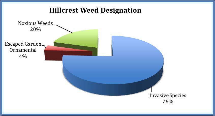
7 INVASIVESPECIES&DESIGNATION The fall survey produced the following list of invasive weeds with designations from the Alberta Weed Control Act. NOTE: In this document, Invasive Species refers to invasive plant species not listed in the Alberta Weed Control Act. Overall Surrounding Weeds Present Weed Designation Total Count Percent of Total Weeds 1 Prohibited Noxious Weeds % 2 Noxious Weeds % 3 Invasive Species % 4 Escaped Garden Ornamental % Abb Common Name Scientific Name Designation of Weeds Type Abs Absinthe Artemisia absinthium Invasive Species 3 bv Bird Vetch Vicia cracca Invasive Species 3 bw Blueweed Echium vulgare Noxious Weeds- AB Weed Control Act 2 thb Bull Thistle Cirsium vulgaris Invasive Species 3 thc Canada Thistle Cirsium arvense Noxious Weeds- AB Weed Control Act 2 Bd Common Burdock Arctium spp. Noxious Weeds- AB Weed Control Act 2 mc Common Mullein Verbascum thapsis Noxious Weeds- AB Weed Control Act 2 tc Common Tansy Tanacetum vulgare Noxious Weeds- AB Weed Control Act 2 cb Creeping Campanula rapunculoides Noxious Weeds- AB Weed Control Act Bellflower 2 td Dalmatian Linaria dalmatica Noxious Weeds- AB Weed Control Act Toadflax 2 DR Dames Rocket Hesperis matronalis Noxious Weeds- AB Weed Control Act 2 bd Downy Brome Bromus tectorum Noxious Weeds- AB Weed Control Act 2 gb Goat s Beard Tragopogon dubius, Invasive Species 3 Ht Houndstongue Cynoglossum officinale Noxious Weeds- AB Weed Control Act 2 do Oxeye Daisy Luecanthemum vulgare Noxious Weeds- AB Weed Control Act 2 sc Scentless Tripleurospermum perforatum Noxious Weeds- AB Weed Control Act Chamomile 2 ks Spotted Knapweed Centurea stoebe Prohibited Noxious Weed-AB Weed Control Act 1 bt Tall Buttercup Ranunculus acris Noxious Weeds- AB Weed Control Act 2 yc Yellow Chamomile Cota tinctoria Escaped Garden Ornamental 4 cy Yellow Clematis Clematis tangutica Noxious Weeds- AB Weed Control Act 2 ty Yellow Toadflax Linaria vulgare Noxious Weeds- AB Weed Control Act 2 7


8 BAREGROUND There is a high potential for invasive weeds to appear on bare ground in riparian areas. It is important to distinguish between naturally rocky areas and bare soil. The percent of bare ground was recorded for each quadrat and those areas with a high percentage of bare ground targeted for planting of native grasses and shrubs. 54% of all quadrats surveyed fall in the poor classification for Riparian Bare Ground, which means the bare ground % rating falls between 0-25%. Riparian Ground Classification Bare Ground % Classification 0-25 Poor Fair Good Excellent 8
9 PERCENTOFBAREGROUNDBYAREA Crowsnest River Riparian Report 2011 Area Location Bare Ground (%) Total Quadrats Class Area Location Bare Ground (%) Total Quadrats Class Blairmore Blairmore 1 10% 2 Poor Coleman E Coleman 1 0% 12 Poor 20% 1 Poor E Coleman 2 0% 2 Poor 30% 2 Fair 10% 1 Poor 50% 1 Fair 20% 1 Poor Blairmore 2 0% 1 Poor 50% 2 Good 10% 1 Poor E Coleman 3 0% 1 Poor 40% 1 Fair 10% 1 Poor 75% 2 Good 40% 1 Fair Blairmore 3 0% 1 Poor W Coleman 0% 1 Poor 10% 3 Poor 20% 1 Poor 15% 1 Poor 25% 1 Fair 20% 2 Poor 45% 1 Fair 80% 1 Excellent 50% 1 Good Blairmore 5 30% 5 Fair Frank Gold Crow 1 0% 2 Poor 40% 1 Fair 10% 2 Poor 70% 3 Good 20% 1 Poor 80% 2 Excellent Gold Crow 2 0% 2 Poor Blairmore 6 5% 1 Poor 5% 1 Poor 60% 1 Good 10% 1 Poor 75% 1 Good 20% 1 Poor 85% 1 Excellent 25% 1 Poor 95% 1 Excellent Gold Crow 3 10% 2 Poor Blairmore 7 15% 1 Poor 30% 2 Fair 35% 1 Fair Gold Crow 4 0% 5 Poor 80% 1 Excellent Hillcrest Drum 1 5% 1 Poor 85% 3 Excellent 15% 1 Poor 90% 1 Excellent 20% 2 Poor Blairmore 8 75% 2 Excellent 50% 1 Good 80% 1 Excellent 100% 1 Excellent 90% 1 Excellent Drum 2 27% 1 Fair 100% 1 Excellent 40% 1 Fair E Blairmore 1 10% 6 Poor 70% 1 Good 25% 1 Fair 80% 2 Excellent 30% 1 Fair 85% 1 Excellent E Blairmore 2 10% 2 Poor Drum 3 30% 1 Fair 60% 2 Good 50% 1 Fair 70% 1 Good 60% 3 Good 75% 1 Excellent 65% 1 Good 80% 1 Excellent 70% 1 Good 99% 1 Excellent Drum 4 30% 2 Fair E Blairmore 3 0% 2 Poor 60% 1 Good 5% 1 Poor E Hillcrest 1 10% 2 Poor 10% 1 Poor 20% 1 Poor 20% 1 Poor 30% 1 Fair Lyons Creek 1 45% 1 Fair 85% 1 Excellent 80% 3 Excellent E Hillcrest 2 0% 1 Poor 85% 2 Excellent 5% 2 Poor Lyons Creek 2 0% 4 Poor 10% 2 Poor 5% 1 Poor 50% 1 Good 10% 2 Poor W Hillcrest 1 0% 3 Poor Lyons Creek 4 80% 1 Excellent 10% 1 Poor 90% 2 Excellent 20% 1 Poor 95% 1 Excellent 30% 2 Fair 98% 1 Excellent W Hillcrest 2 0% 2 Poor Lyons Creek 5 15% 2 Poor 20% 1 Poor 30% 2 Fair Sentinel Crowsnest Lake 1 0% 1 Poor 40% 3 Fair Crowsnest Lake 2b 0% 4 Poor 80% 1 Excellent 5% 1 Poor 9
10 WEEDCOVER The percent of weed cover was recorded for each quadrat in the fall. Frank and Coleman both have a 19% weed cover in the surveyed areas. Weed pull efforts in 2011 focused on Blairmore and Hillcrest (with larger areas of municipally-owned land adjacent to water bodies), resulting in a reduction of weed cover to 10% in Blairmore and 8% in Hillcrest. The weeds surrounding each quadrat were also observed, with 70% of these weeds classified as noxious according to the Alberta Weed Control Act. However, we recognize that 3 types of prohibited noxious weeds in the Crowsnest Pass riparian areas were missed by the random sampling process used in Adjustments to the sampling process in 2012 will be made to address this. Weed Designation Coleman Blairmore Frank Hillcrest Sentinel Prohibited Noxious Weeds 0% 0% 0% 0% 0% Noxious Weeds 15.89% 5.60% 13.63% 0.50% Invasive Species 2.72% 4.18% 5.70% 7.43% Escaped Garden Ornamental 0% 0% 0% 0.37% 0% Weed Cover % 18.61% 9.78% 19.33% 7.80% 0.50% 10


11 WEEDCOVERBLAIRMORE10% Fall 2011 Blairmore Weed Cover Weed Cover % Bird Vetch Blueweed Canada Thistle Common Tansy Oxeye Daisy Tall Buttercup Yellow Toadflax Blairmore Average Weed Cover 9.78% 4.18% 2.57% 0.12% 1.52% 0.40% 0.21% 0.78% Weed Designation

12 WEEDCOVERCOLEMAN19% Fall 2011 Coleman Average Weed Cover Weed Cover % Absinthe Bird Vetch Canada Thistle Common Tansy Dalmatian Toadflax Oxeye Daisy Tall Buttercup Coleman Average Weed Cover 18.61% 0.83% 1.89% 2.82% 11.67% 0.25% 0.36% 0.79% Weed Designation

13 WEEDCOVERFRANK19% Fall 2011 Frank Average Weed Cover Weed Cover % Bird Vetch Blueweed Canada Thistle Common Tansy Oxeye Daisy Yellow Toadflax Frank Average Weed Cover 19.33% 5.70% 2.50% 1.30% 6.60% 0.63% 2.60% Weed Designation


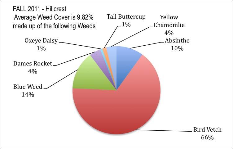
14 WEEDCOVERHILLCREST10% Fall 2011 Hillcrest Average Weed Cover Weed Cover % Absinthe Bird Vetch Blueweed Dames Rocket Oxeye Daisy Tall Buttercup Yellow Chamomile Hillcrest Average Weed Cover 9.82% 0.98% 6.45% 1.38% 0.41% 0.08% 0.15% 0.37% Weed Designation
15 15
16 SURROUNDINGWEEDSPRESENT The total number of weeds surrounding each transect was calculated. 70% of the surrounding weeds present are noxious weeds. We were able to calculate for each weed the % of total transects around which they were observed. Note the total number of transects is 32. Number of Transects with Surrounding Weeds Present Bird Vetch Bull Thistle Canada Thistle Common Burdock Common Mullein Common Tansy Creeping Bellflower Location Absinthe Blueweed Hillcrest Blairmore Coleman Frank Sentinel Total transects Percent of Transects Dalmatian Toadflax 22% 38% 41% 3% 34% 6% 13% 53% 9% 19% Number of Transects with Surrounding Weeds Present Dames Rocket Downy Brome Goat's Beard Oxeye Daisy Scentless Chamomile Spotted Knapweed Tall Buttercup Yellow Chamomile Location Houndstongue Hillcrest Blairmore Coleman Frank Sentinel Total transects Percent of transects Yellow Toadflax 19% 6% 19% 9% 38% 3% 3% 16% 6% 19% 16
17 17
18 BLAIRMORESURROUNDINGINVASIVESPECIES Location Transect Absinthe Bird Vetch Blueweed Canada Thistle Common Mullein Common Tansy Creeping Bellflower Dalmatian Toadflax Goat's Beard Oxeye Daisy Tall Buttercup Yellow Toadflax Weed Designation Blairmore 1 5 Blairmore 2 7 Blairmore 3 9 Blairmore 5 10 Blairmore 6 11 Blairmore 7 12 Blairmore 8 13 E Blairmore 1 4 E Blairmore 2 3 E Blairmore 3 14 Lyons Creek 1 8 Lyons Creek 2 6 Lyons Creek 4 2 Lyons Creek 5 1 Total Transects % of Transects 7% 50% 57% 14% 7% 64% 14% 7% 14% 43% 7% 21% COLEMANSURROUNDINGINVASIVESPECIES Location Transect Absinthe Bird Vetch Blueweed Bull Thistle Canada Thistle Common Mullein Common Tansy Creeping Bellflower Dalmatian Toadflax Dames Rocket Goat's Beard Houndstongu e Oxeye Daisy Tall Buttercup Yellow Toadflax Weed Type E Coleman 1 16 E Coleman 3 17 E Coleman 2 18 W Coleman 19 Total Transects % of Transects 50% 50% 25% 25% 100% 25% 25% 25% 75% 25% 25% 25% 25% 50% 25% 18
19 FRANKSURROUNDINGINVASIVESPECIES Location Transect Blueweed Common Burdock Canada Thistle Common Mullein Common Tansy Dames Rocket Goat's Beard Houndstongue Oxeye Daisy Spotted Knapweed Tall Buttercup Yellow Toadflax Weed Type Gold Crow 1 22 Gold Crow 2 23 Gold Crow 3 24 Gold Crow 4 25 Total Transects % of Transects 25% 25% 100% 50% 100% 50% 25% 25% 75% 25% 25% 75% HILLCRESTSURROUNDINGINVASIVESPECIES Location Transect Absinthe Bird Vetch Blueweed Common Burdock Canada Thistle Common Tansy Dalmatian Toadflax Dames Rocket Downy Brome Goat's Beard Houndstongue Oxeye Daisy Scentless Chamomile Tall Buttercup Yellow Chamomile Weed Type E Hillcrest 2 26 E Hillcrest 1 27 Drum 4 28 Drum 1 29 Drum 2 30 Drum 3 31 W Hillcrest 1 32 W Hillcrest 2 33 Total Transects % of Transects 50% 38% 38% 13% 13% 38% 25% 38% 25% 25% 13% 25% 13% 13% 25% 19

20 DENSITYDISTRIBUTIONOFWEEDS Calculating weed density distribution in each quadrat can help identify remediation areas and measure progress in managing the spread of weeds in riparian areas. Each quadrat was given a Density Distribution Class rating based on the cover and distribution of noxious weeds. 46% of all the quadrats surveyed were identified as high priority areas, which will be targeted in GREEN: No noxious or restricted weeds present (Density Distribution Class 0) Action: Monitoring only YELLOW: Noxious weeds present; total weed cover is less than 1 percent (Density Distribution Class 1, 2 or 3) Action: Low Priority; monitoring and regular weeding in the areas to contain spread. RED: Restricted or noxious weeds present; total weed cover is greater than 1 percent (Density Distribution Class 4 to 13) Action: High priority; target areas for 2012 weed control program. 20

21 COLEMAN Location Action Weed abundance in each quadrat Class Quadrats E Coleman 1 Green None 0 2 Yellow A single patch 3 2 Red A single patch plus a few sporadically occurring plants 4 2 Red Several sporadically occurring plants 5 4 Red A few patches 7 2 E Coleman 2 Green None 0 3 Red Several sporadically occurring plants 5 1 Red A few patches 7 2 E Coleman 3 Red Several sporadically occurring plants 5 1 Red Continuous occurrence of plants with a few gaps in the distribution 11 1 Red Continuous dense occurrence of plants 12 1 W Coleman Green None
22 BLAIRMORE Location Action Weed abundance in each quadrat Class Quadrats Blairmore 1 Green None 0 3 Red A single patch plus a few sporadically occurring plants 4 1 Red Several well-spaced patches 9 2 Blairmore 2 Green None 0 2 Yellow Rare 1 1 Yellow A single patch 3 1 Red Several sporadically occurring plants 5 1 Blairmore 3 Green None 0 5 Yellow A few sporadically occurring individual plants 2 1 Yellow A single patch 3 1 Red A single patch plus a few sporadically occurring plants 4 1 Blairmore 5 Yellow A single patch 3 3 Red Several sporadically occurring plants 5 5 Red A few patches 7 2 Blairmore 6 Green None 0 2 Red Several sporadically occurring plants 5 1 Red Several well-spaced patches 9 2 Blairmore 7 Green None 0 2 Yellow Rare 1 2 Yellow A single patch 3 1 Red Several sporadically occurring plants 5 2 Blairmore 8 Green None 0 2 Red A single patch plus a few sporadically occurring plants 4 1 E Blairmore 1 Yellow Rare 1 1 Yellow A single patch 3 1 Red Several sporadically occurring plants 5 1 Red A few patches 7 1 Red Several well-spaced patches 9 3 E Blairmore 2 Red A single patch plus a few sporadically occurring plants 4 2 Red A single patch plus several sporadically occurring plants 6 1 Red A few patches 7 1 E Blairmore 3 Yellow A few sporadically occurring individual plants 2 1 Red Several sporadically occurring plants 5 1 Red A few patches 7 1 Red Several well-spaced patches 9 1 Lyons Creek 1 Yellow A single patch 3 3 Red A single patch plus a few sporadically occurring plants 4 1 Red Several sporadically occurring plants 5 2 Lyons Creek 2 Green None 0 1 Yellow A single patch 3 1 Red Several sporadically occurring plants 5 1 Red A few patches 7 2 Red Several well-spaced patches 9 2 Lyons Creek 4 Green None 0 3 Yellow A single patch 3 1 Red Several sporadically occurring plants 5 1 Lyons Creek 5 Green None 0 1 Yellow A single patch 3 1 Red A single patch plus a few sporadically occurring plants 4 1 Red Several sporadically occurring plants 5 2 Red A few patches
23 FRANK Location Action Weed abundance in each quadrat Class Quadrats Gold Crow 1 Yellow Rare 1 2 Yellow A single patch 3 1 Red A few patches 7 1 Red Several well-spaced patches 9 1 Red Continuous occurrence of plants with a few gaps in the distribution 11 2 Gold Crow 2 Yellow Rare 1 1 Yellow A few sporadically occurring individual plants 2 5 Yellow A single patch 3 1 Red A single patch plus a few sporadically occurring plants 4 1 Red Several sporadically occurring plants 5 2 Red A few patches 7 1 Red Several well-spaced patches 9 1 Red Continuous occurrence of plants with a few gaps in the distribution 11 1 Gold Crow 3 Yellow A single patch 3 3 Red Several sporadically occurring plants 5 4 Red A few patches 7 3 Red Several well-spaced patches 9 2 Gold Crow 4 Yellow A single patch 3 1 Red Several sporadically occurring plants 5 2 Red A few patches 7 3 Red Several well-spaced patches 9 1 HILLCREST Location Action Weed abundance in each quadrat Class Quadrats Drum 1 Green None 0 2 Yellow Rare 1 2 Yellow A single patch 3 1 Drum 2 Green None 0 1 Yellow Rare 1 3 Yellow A few sporadically occurring individual plants 2 2 Yellow A single patch 3 1 Drum 3 Yellow A few sporadically occurring individual plants 2 2 Yellow A single patch 3 2 Red A single patch plus a few sporadically occurring plants 4 2 Drum 4 Green None 0 1 Yellow Rare 1 2 Yellow A single patch 3 2 Red A single patch plus a few sporadically occurring plants 4 1 E Hillcrest 1 Green None 0 2 E Hillcrest 2 Green None
24 SENTINEL Location Action Weed abundance in each quadrat Class Quadrats Crowsnest Lake 1 Green None 0 1 Crowsnest Lake 2b Green None 0 3 Yellow Rare


25 RESTORATIONSITES SITE1 PARKBRIDGE,LIONSPARK Way Points: N W Action: Seed Completed: September 26, 2011 Species: Native grass seed mix, Comments: Used hand held broadcaster and raked grass seed into the soil. Then packed with feet and watered on September 26, SITE2POPLARBLOCK,LYONSCREEK Way Points: N W Action: Plant Shrubs Completed: September 15, 2011 Species: River Alder x 3, Rose x 3, Mountain Maple x 1 Comments: Watered on September 15, 22, 28 and on September 30, 2011; applied Plantskyde (pig s blood deer deterrent) on September 30,


26 SITE3 ALLEY/GASLINE Way Points: N W Action: Seed Completed: October 7, 2011 Species: Native Grass Seed mix.23 kg and 7.9 meters Comments: Notify gas line operator if any digging is being done. SITE4 GRASSYBANK Way Points: N W Action: Shade intolerant shrubs higher on bank, Willow Stakes Completed: October 27, 2011 Species: 3 Prickly Rose; 3 Wild Rose; 3 White Spruce; 4 Aspen Poplar; 2 Green Alder Comment: Larger site; watered and Plantskyde on October 27,


27 SITE5 ROCKYTREED Way Point: N W Action: Seed Completed: October 7, 2011 Species: Native Grass Seed mix 1.25 kg and 35 meters SITE6 GARBAGEGRASS Way Points: N W Completed: October 25, 2011 Action: Seed Species: Native Grass Seed mix.57 kg Comments: Notify gas line operators if digging is to done. 27


28 SITE 7 TANSYGRASS Way Points: N W Action: Shrubs Completed: October 3, 2011 Species: Above --Aspen Poplar 2; River Birch 4; Green Alder 1; Shrubby Cinquefoil 3; Creeping Juniper 1 Below --Wild Rose 1; Prickly Rose 2; Comments: Major potential for restoration on this site, lots of tansy. Watered Oct 3, and Plantskyde on October 20, SITE8 SLIDINGROCKS Way Points: N W Action: Shade intolerant shrubs higher on bank, grass lower on bank, dig in rocks to create habitat Completed: September 28, 2011 Species: Above White Spruce -3; Juniper 5; Shrubby Cinquefoil - 4; Wild Rose- 5; Prickly Rose -3; Trembling Aspen -2; Below -- Native Grass Seed mix 2 hand seeder loads Comments: This is a larger site, requires a higher priority; Used method to create micro sites for grass seed. (Time intensive). Watered Sept 26, 30 and October 20, Plantskyde September 30,


29 SITE 9 STEEP BANK Way Points: N W Action: Seed Completed: October 7, 2011 Species: Native Grass Seed mix 1.36 kg and over 32 meters SITE10RIVERRIDGESTRIP Way Points: N W N W Completed: October 21, 2011 Action: Seed; Shrubs and Willow Stakes Species: Native Grass Seed mix 1.93 kg and over 47.5 meters one pass; Planted Wild Rose -6; Prickly Rose 5; Aspen Poplar -6; Green Alder 4; Shrubby Cinquefoil 2; Creeping Juniper 2; White Spruce -2; Willow Stakes total 28 Comment: October 21 was the willow stake community workshop. 29

30 SITE11 RIVERSIDEPARKAREA Way Points: N W N W Completed: September 30, 2011 Action: Seed; Shrubs & Tress Planted Species: Riparian Mix 1.7 kg and 40 meters. A total of 52 plants have been planted in the park along the riparian areas. Comment: Plantskyde on September 30 th, Significant rainfall on October 5 th and 6 th,
2016 Summit County Weed Control Cost Share Application
 2016 Summit County Weed Control Cost Share Application For any Non-Governmental entities owning or operating taxable land in Summit County. Please read and fill out entire application carefully and completely.
Garfield County Vegetation Management Bookcliff, Mount Sopris & South Side Conservation Districts 2016 Noxious Weed Cost Share Program
 Garfield County Vegetation Management Bookcliff, Mount Sopris & South Side Conservation Districts 2016 Noxious Weed Cost Share Program On site visit required by Garfield County Vegetation Management (970)
Garfield County Vegetation Management Bookcliff, Mount Sopris & South Side Conservation Districts 2015 Noxious Weed Cost Share Program
 Garfield County Vegetation Management Bookcliff, Mount Sopris & South Side Conservation Districts 2015 Noxious Weed Cost Share Program On site visit required by Garfield County Vegetation Management (970)
THE ALBERTA GAZETTE, PART II, APRIL 15, Alberta Regulation 18/2010. Emblems of Alberta Act OFFICIAL EMBLEMS AMENDMENT REGULATION
 Alberta Regulation 18/2010 Emblems of Alberta Act OFFICIAL EMBLEMS AMENDMENT REGULATION Filed: March 18, 2010 For information only: Made by the Minister of Culture and Community Spirit (M.O. 02/10 CCS)
2011 End of Year Report
 2011 End of Year Report Johnson County Weed and Pest Control District Mission and Policy The Johnson County Weed & Pest is committed to providing leadership and education for the long term management of
Pêches et Océans Canada. Your file Votre référence March 20, Our file Notre référence 14-HCAA-00788
 Fisheries and Oceans Canada Pêches et Océans Canada 501 University Crescent Winnipeg, MB R3T 2N6 Your file Votre référence March 20, 2017 80101 Our file Notre référence 14-HCAA-00788 Canadian Environmental
KITTITAS COUNTY CONSERVATION DISTRICT KITTITAS COUNTY, WASHINGTON RESOLUTION NO
 KITTITAS COUNTY CONSERVATION DISTRICT KITTITAS COUNTY, WASHINGTON RESOLUTION NO. 2016-002 Kittitas County Conservation District A RESOLUTION of the Board of Supervisors of Kittitas County Conservation
In-Lieu Fee Program Instrument Outline For Proposed In-Lieu Fee Programs in the States of Kansas and Missouri
 In-Lieu Fee Program Instrument Outline For Proposed In-Lieu Fee Programs in the States of Kansas and Missouri The U.S. Army Corps of Engineers (Corps) and U.S. Environmental Protection Agency joint regulation
Sheppard s Bush Conservation Area Management Plan Presentation to LSRCA Board of Directors December 15, 2017 Lauren Grzywniak
 Sheppard s Bush Conservation Area Management Plan Presentation to LSRCA Board of Directors December 15, 2017 Lauren Grzywniak Member of Conservation Ontario Presentation Overview History of Sheppard s
APPENDIX 1 PROSPECTUS STATEWIDE UMBRELLA MITIGATION BANK INSTRUMENT FOR NORTH DAKOTA. North Central Mitigation, LLC PO Box 2009 Sioux Falls, SD 57101
 4/20/2018 APPENDIX 1 STATEWIDE UMBRELLA MITIGATION BANK INSTRUMENT FOR NORTH DAKOTA PROSPECTUS North Central Mitigation, LLC PO Box 2009 Sioux Falls, SD 57101 This page intentionally left blank TABLE OF
REQUEST FOR PROPOSAL FOR VAIL/USFS NOXIOUS WEED CONTROL SERVICES
 REQUEST FOR PROPOSAL FOR VAIL/USFS NOXIOUS WEED CONTROL SERVICES May 20, 2016 The Town of Vail Department of Public Works is seeking a qualified contractor to provide Noxious Weed Control Services in partnership
Appendix 4 Departments
 Appendix 4 Departments Organizational Chart For the detailed organizational charts for each department refer to the Departmental Summaries Personnel Summary Mountain View County 2015 BUDGET Salaries, Wages
PRESENT Maria Augimeri. Ronald Chopowick. THAT the Minutes of Meeting #3/16, held on October 14, 2016, be approved. CARRIED
 Budget Audit Advisory Board Meeting #1/17 was held at TRCA Head Office, on Friday, March 24, 2017. The Chair Maria Augimeri, called the meeting to order at 8:33 a.m. PRESENT Maria Augimeri Jack Ballinger
Expansion of Mine Waste Rock Dump, Talison Lithium Greenbushes Operation, EPBC Annual Compliance Summary Report September 2017
 Condition No. 1 The person taking the action must not clear more than 75.7 hectares (ha) of black cockatoo habitat within the project area. 2 Within 7 days prior to clearing of any area of black cockatoo
NAPA COUNTY FLOOD CONTROL AND WATER CONSERVATION DISTRICT Board Agenda Letter
 Agenda Date: 6/7/2016 Agenda Placement: 8A Set Time: 1:30 PM PUBLIC HEARING Estimated Report Time: 20 Minutes NAPA COUNTY FLOOD CONTROL AND WATER CONSERVATION DISTRICT Board Agenda Letter TO: FROM: Board
ANNEX B: TOWN OF BLUE RIVER
 ANNEX B: TOWN OF BLUE RIVER B.1 Community Profile Figure B.1 shows a map of the Town of Blue River and its location within Summit County. Figure B.1. Map of Blue River Summit County (Blue River) Annex
FY Biennial Budget Request St Louis, South SWCD
 FY 18-19 Biennial Budget Request St Louis, South SWCD Total Requested Biennial State Contribution: $2,861,816.00 BBR ID BBR16-3852 Total Leveraged Funds $782,803.00 Submitted Date 4/15/2016 Total Resource
Water Temperature Monitoring in the San Joaquin River Restoration Area
 Water Temperature Monitoring in the San Joaquin River Restoration Area 2013 Summary and Available Data Prepared by: Brian Mahardja, Environmental Scientist California Department of Fish and Wildlife San
COMMUNITY CONSOLIDATED SCHOOL DISTRICT 59
 March 10, 2017 The proposed Community Consolidated School District 59 (CCSD 59) Administration/Professional Development building will house the Administrative and Maintenance staff, providing for the administrative
Bucks County, PA Flood Risk Review Meeting. November 2014
 Bucks County, PA Flood Risk Review Meeting November 2014 Agenda for Today Risk MAP Program overview Overview of non-regulatory Flood Risk Products and datasets Discuss mitigation action Technical overview
West Virginia Stream and Wetland Valuation Metric v2.0 (February 2011)
") West Virginia Stream and Wetland Valuation Metric v2.0 (February 2011) The SWVM is composed of six tabs including the following: Instructions, Stream Parts I-II, Stream Parts III-VI, Multiple Site Unit
West Virginia Stream and Wetland Valuation Metric v2.0 (February 2011) The SWVM is composed of six tabs including the following: Instructions, Stream Parts I-II, Stream Parts III-VI, Multiple Site Unit
Upper Tukituki Flood Control Scheme. Asset Management Plan. October 2017 HBRC Plan Number 4559 HBRC Report Number AM 15-04
 Upper Tukituki Flood Control Scheme Asset Management Plan October 2017 HBRC Plan Number 4559 HBRC Report Number AM 15-04 Asset Management Group Technical Report ISSN 1174 3085 Engineering Section Upper
2012 End of Year Report
 2012 End of Year Report Johnson County Weed and Pest Control District Mission and Policy The Johnson County Weed & Pest is committed to providing leadership and education for the long term management of
ASFPM Partnerships for Statewide Mitigation Actions. Alicia Williams GIS and HMP Section Manager, Amec Foster Wheeler June 2016
 ASFPM Partnerships for Statewide Mitigation Actions Alicia Williams GIS and HMP Section Manager, Amec Foster Wheeler June 2016 Summary The Concept Leveraging Existing Data and Partnerships to reduce risk
Red Knight Restoration Project Environmental Assessment (EA) Appeal Statements and Responses Fremont-Winema National Forest December 2013
 Appeal Statements and Responses Fremont-Winema National Forest December 2013") Red Knight Restoration Project Environmental Assessment (EA) Appeal Statements and Responses Fremont-Winema National Forest December 2013 Appellant Appeal Number Dick Artley 14-06-00-0001-215 Fisheries
Red Knight Restoration Project Environmental Assessment (EA) Appeal Statements and Responses Fremont-Winema National Forest December 2013 Appellant Appeal Number Dick Artley 14-06-00-0001-215 Fisheries
ARTICLE 2 ADMINISTRATIVE PROVISIONS
 WHATCOM COUNTY CRITICAL AREAS ORDINANCE 16.16.200 Authority ARTICLE 2 ADMINISTRATIVE PROVISIONS This Chapter is adopted under the authority of Chapters 36.70 and 36.70A, RCW and Article 11 of the Washington
GREAT SOUTH ROAD INTERSECTION
 TECHNICAL REPORT 16 ECOLOGICAL IMPACT SUPPLEMENTARY ASSESSMENT GREAT SOUTH ROAD INTERSECTION DECEMBER 2016 Quality Assurance Statement Prepared by Reviewed by Shona Myers Katherine Muchna Shona Myers Approved
Technical Appendix: Protecting Open Space & Ourselves: Reducing Flood Risk in the Gulf of Mexico Through Strategic Land Conservation
 Technical Appendix: Protecting Open Space & Ourselves: Reducing Flood Risk in the Gulf of Mexico Through Strategic Land Conservation To identify the most effective watersheds for land conservation, we
Marin County Flood Control and Water Conservation District FLOOD CONTROL ZONE 5 ADVISORY BOARD MAY 15, 2014 STAFF REPORT
 FLOOD CONTROL ZONE 5 ADVISORY BOARD MAY 15, 2014 STAFF REPORT Item 1. Approval of Meeting Minutes for February 10, 2014 Recommended Action: Approve minutes. Item 2. Open Time for Items not on the Agenda
Village of Blue Mounds Annex
 Village of Blue Mounds Annex Community Profile The Village of Blue Mounds is located in the southwest quadrant of the County, north of the town of Perry, west of the town of Springdale, and south of the
Appendix 4 Departments
 Appendix 4 Departments Organizational Chart For the detailed organizational charts for each department refer to the Departmental Summaries Personnel Summary Mountain View County 2012 BUDGET Salaries, Wages
The Economic Impacts of Restoration
 A Research Paper by The Economic Impacts of Restoration Custer and Lemhi Counties, Idaho April 2014 The Economic Impacts of Restoration Custer and Lemhi Counties, Idaho April 2014 PUBLISHED ONLINE: http://headwaterseconomics.org/land/reports/idaho-restoration-impacts
Toronto & Region Conservation Authority (TRCA)
") OPERATING ANALYST NOTES OPERATING PROGRAM SUMMARY Contents Toronto & Region Conservation Authority (TRCA) 2014 OPERATING BUDGET OVERVIEW What We Do TRCA protects, restores and celebrates the natural environment
OPERATING ANALYST NOTES OPERATING PROGRAM SUMMARY Contents Toronto & Region Conservation Authority (TRCA) 2014 OPERATING BUDGET OVERVIEW What We Do TRCA protects, restores and celebrates the natural environment
MAY 2, Overview
 TESTIMONY OF GLENN CASAMASSA ASSOCIATE DEPUTY CHIEF, NATIONAL FOREST SYSTEM UNITED STATES DEPARTMENT OF AGRICULTURE FOREST SERVICE BEFORE THE COMMITTEE ON ENERGY AND NATURAL RESOURCES UNITED STATES SENATE
REQUEST FOR PROPOSALS FOR VAIL NATIVE SEEDING 2015
 TOWN OF VAIL DEPARTMENT OF PUBLIC WORKS AND TRANSPORTATION 1309 Elkhorn Drive Vail, CO 81657 REQUEST FOR PROPOSALS FOR VAIL NATIVE SEEDING 2015 July 15, 2015 The Town of Vail Department of Public Works
Please bring your lunch
 Lewis River Hydroelectric Projects Settlement Agreement Terrestrial Coordination Committee (TCC) Meeting Agenda Date & Time: Wednesday, June 12, 2013 9:00 a.m. 3:00 p.m. Place: Merwin Hydro Control Center
Appendix 4 Departments
 Appendix 4 Departments Organizational Chart For the detailed organizational charts for each department refer to the Departmental Summaries Personnel Summary Mountain View County 2014 BUDGET Salaries, Wages
CAPITAL REPLACEMENT RESERVE FUND STUDY. April Prepared for. Condominium Corporation Operating as: Birchwood County Condo
 CAPITAL REPLACEMENT RESERVE FUND STUDY Prepared for Operating as: Birchwood County Condo Contact: Jan Wells, Vice President (780) 542-3153 P.O. Box 134 Lindale, Alberta T0C 1W0 Email: mail@birchwoodcountrycondo.com
Flood Risk Review (FRR) Meeting. Cumberland County, Pennsylvania Carlisle, Pennsylvania December 5, 2016
 Meeting. Cumberland County, Pennsylvania Carlisle, Pennsylvania December 5, 2016") Flood Risk Review (FRR) Meeting Cumberland County, Pennsylvania Carlisle, Pennsylvania December 5, 2016 Why are we here today? The Flood Insurance Study (FIS) report and Flood Insurance Rate Maps (FIRMs)
Flood Risk Review (FRR) Meeting Cumberland County, Pennsylvania Carlisle, Pennsylvania December 5, 2016 Why are we here today? The Flood Insurance Study (FIS) report and Flood Insurance Rate Maps (FIRMs)
Kittitas County Conservation District. Rate Study Report June 2016
 Kittitas County Conservation District Rate Study Report June 2016 Kittitas County Conservation District 2211 W Dolarway Road, Suite 4 Ellensburg WA 98926 T: 509.925.3352 888.546.0825 FCS Group 7525 166
INVITATION FOR BID Noxious Weed Treatments
 INVITATION FOR BID Noxious Weed Treatments Confederated Tribes of the Umatilla Indian Reservation North Fork John Day Basin Fish Habitat Restoration Project Department of Natural Resources CONTRACTORS
GEAUGA PARK DISTRICT Bessie Benner Metzenbaum Park Restoration Request for Proposals (Design-Build Services) February 15, Geauga Park District
 February 15, Geauga Park District") GEAUGA PARK DISTRICT Bessie Benner Metzenbaum Park Restoration Request for Proposals (Design-Build Services) February 15, 2018 Geauga Park District Board of Park Commissioners Andrej Lah, President Jackie
GEAUGA PARK DISTRICT Bessie Benner Metzenbaum Park Restoration Request for Proposals (Design-Build Services) February 15, 2018 Geauga Park District Board of Park Commissioners Andrej Lah, President Jackie
DIVISION OF WATER RESOURCES
 DEPARTMENT OF NATURAL RESOURCES DIVISION OF WATER RESOURCES John W. Hickenlooper Governor Mike King Executive Director Dick Wolfe, P.E. Director/State Engineer Alan C. Martellaro, P.E. Division Engineer
5. ROAD AND TRAIL DECISION-MAKING PROCESS
 5. ROAD AND TRAIL DECISION-MAKING PROCESS This chapter describes the decision-making process the MCOSD will use to determine the road and trail system it will designate, manage, and maintain. Existing
Pacific Northwest Region. CERTIFIED MAIL RETURN 52 Thurlow Rd. RECEIPT REQUESTED Twisp, WA NUMBER:
 United States Department of Agriculture Forest Service Pacific Northwest Region 333 SW First Avenue PO Box 3623 Portland, OR 97208-3623 503-808-2468 File Code: 1570 Date: February 17, 2012 Mr. Bernard
GENERAL SPECIFICATIONS Tree Planting Project SGL 099
 GENERAL SPECIFICATIONS Tree Planting Project SGL 099 I. SCOPE OF WORK: The Pennsylvania Game Commission (PGC), Southcentral Region, requires tree planting services on 16 acres of State Game Lands (SGL)
Financial Statements. Toronto and Region Conservation Authority. December 31, 2014
 Financial Statements Toronto and Region Conservation Authority December 31, 2014 Contents Page Independent Auditor s Report 1-2 Statement of Financial Position 3 Statement of Operations and Accumulated
STORMWATER MANAGEMENT FUND DEPARTMENT OF ENVIRONMENTAL SERVICES
 DEPARTMENT OF ENVIRONMENTAL SERVICES Mission: To implement a comprehensive stormwater management program that balances the following goals: 1) to reduce the potential for stormwater threats to public health,
2018 Grassland Stewardship Program Application Form
 OFFICE USE ONLY OSCIA Application ID Date Received Level Allocation Notes Status / Initials CONTACT INFORMATION 2018 Grassland Stewardship Program Application Form Name: Email: Phone: FARM BUSINESS INFORMATION
Minutes Educational Advisory Committee (EAC) 15 October :00-4:00 pm
 15 October :00-4:00 pm") Minutes Educational Advisory Committee (EAC) 15 October 2018-2:00-4:00 pm In Attendance: Ken Fisher, Forestry Willie Lantz, Agriculture Greg Rouse, Recreation Gary Shafer, Property Owner Bob Sutton, Property
Minutes Educational Advisory Committee (EAC) 15 October 2018-2:00-4:00 pm In Attendance: Ken Fisher, Forestry Willie Lantz, Agriculture Greg Rouse, Recreation Gary Shafer, Property Owner Bob Sutton, Property
Water Temperature Monitoring in the San Joaquin River Restoration Area
 Water Temperature Monitoring in the San Joaquin River Restoration Area Introduction 2012 Summary and Available Data Principal Investigator: Erica M. Meyers, Environmental Scientist California Department
Pacific Coastal Salmon Recovery Fund
 Pacific Coastal Salmon Recovery Fund Project Progress Report Format For FYs 2004-2006 Send progress reports by email by April 30, 2007 to the following address: Columbia River Inter-Tribal Fish Commission
FURTHER TO EXECUTIVE COMMITTEE MEETING #13/11 To be held on Friday, February 3, 2012
 FURTHER TO EXECUTIVE COMMITTEE MEETING #13/11 To be held on Friday, February 3, 2012 FURTHER TO: Pages EX6. CORRESPONDENCE EX6.1 A letter dated January 11, 2012 from Mr. David de Launay, Assistant Deputy
***EXPEDITED REVIEW***
 ***EXPEDITED REVIEW*** Application for Erosion and Sediment Pollution Control Plan Adequacy Review General NPDES Plan Review This application must be completed and accompanied by the required fees, plans,
STORMWATER MANAGEMENT FUND Department of Environmental Services
 Department of Environmental Services Mission: To implement a comprehensive stormwater management program that balances the following goals: 1) to reduce the potential for stormwater threats to public health,
Financial Statements December 31, 2016 Rocky Mountain Bird Observatory d/b/a Bird Conservancy of the Rockies. (With Comparative Totals for 2015)
") Financial Statements Rocky Mountain Bird Observatory d/b/a (With Comparative Totals for 2015) Table of Contents Independent Auditor s Report... 1 Financial Statements Statement of Financial Position...
Financial Statements Rocky Mountain Bird Observatory d/b/a (With Comparative Totals for 2015) Table of Contents Independent Auditor s Report... 1 Financial Statements Statement of Financial Position...
Invasive Species Control (Mechanical and Herbicide Application) Niagara Gorge in Whirlpool State Park, Niagara Falls Request for Proposal (RFP)
 Niagara Gorge in Whirlpool State Park, Niagara Falls Request for Proposal (RFP)") Invasive Species Control (Mechanical and Herbicide Application) Niagara Gorge in Whirlpool State Park, Niagara Falls Request for Proposal (RFP) Western New York Land Conservancy P.O. Box 471 East Aurora,
Invasive Species Control (Mechanical and Herbicide Application) Niagara Gorge in Whirlpool State Park, Niagara Falls Request for Proposal (RFP) Western New York Land Conservancy P.O. Box 471 East Aurora,
Federal Emergency Management Agency
 Page 1 of 4 Issue ate: May 18, 2012 Follows Conditional Case No.: 08-06-1597R ETERMINATION OCUMENT COMMUNITY AN REVISION INFORMATION PROJECT ESCRIPTION BASIS OF REQUEST COMMUNITY Harris County Texas (Unincorporated
FY Budgeted Expenditures by Fund $900.2 Million
 Page 1 of 25 DNR FY 2010-11 Budget 2010 Supplement Where Funding Comes From Funding for state programs is contained in the Biennial (two-year) Budget that is passed by the State Legislature during the
Toronto and Region Conservation Authority
 OPERATING BUDGET NOTES Toronto and Region Conservation Authority 2018 OPERATING BUDGET OVERVIEW Toronto and Region Conservation Authority (TRCA) protects, restores and celebrates the natural environment
Engineer s Report: School Section Lake Outlet 2017
 WENCK File #0002-0230 June 2017 Revised August 2017 Engineer s Report: School Section Lake Outlet 2017 Prepared for: Clearwater River Watershed District 75 Elm St E PO Box 481 Annandale, MN 55389 Prepared
April 13, 2016 TCC Meeting HCC
 FINAL Meeting Notes Lewis River License Implementation Terrestrial Coordination Committee (TCC) Meeting March 9, 2016 Merwin Hydro Control Center & Field Tour Ariel, WA TCC Participants Present: (9) Ray
Request for Proposals. Silver Cliff Ranch-Forest Stand Improvement
 CONTRACTOR BID AND REQUEST FOR PROPOSALS---Request for Bids and Contractor Bid incorporated by reference. Work scope is as outlined in the Request for Bids and per instruction of ARWC project manager.
SHIPLEY S CHOICE DAM REHABILITATION COMMUNITY MEETING MINUTES
 SHIPLEY S CHOICE DAM REHABILITATION COMMUNITY MEETING MINUTES A community meeting was held on September 13, 2018 at the Shipley s Choice Elementary School. County staff from the Watershed Protection and
Meet Your New Webmaster
 September 2007 Meet Your New Webmaster Contents New Webmaster 1 The WHOA association Board invited HO Laurie Grasso to the August meeting as she had expressed a willingness to look at the existing website
Public Notice. Activity: Fort Worth District Mitigation Banks. Date: January 24, 2019
 Public Notice Number: CESWF-18-MITB Activity: Fort Worth District Mitigation Banks Date: January 24, 2019 Purpose The purpose of this Public Notice is to inform you of mitigation banking guidelines being
REQUEST FOR PROPOSALS. Planning in Water s Way: Flood Resilient Economic Development Strategy for the I-86 Innovation Corridor
 REQUEST FOR PROPOSALS Planning in Water s Way: Flood Resilient Economic Development Strategy for the I-86 Innovation Corridor Southern Tier Central Regional Planning and Development Board (STC) is seeking
Prescribed Burning: Liability and Insurance Considerations
 ERM-035 8/17 Prescribed Burning: Liability and Insurance Considerations M.L. Russell and T.D. Lashmet* Throughout Texas, prescribed burning is a popular grassland management tool you can use to manage
Budget/Audit Advisory Board Meeting #1/15
 Budget/Audit Advisory Board Meeting #1/15 Chair: Vice Chair: Members: Maria Augimeri Rob Ford Colleen Jordan Gino Rosati John Sprovieri April 10, 2015 8:30 A.M. WESTON ROOM B, BLACK CREEK PIONEER VILLAGE
Section 1. Status of Restoration Compliance Report
 Section 1 Status of Restoration Compliance Report Chapter 1 Status of Restoration Compliance Report Compliance with State Water Resources Control Board Decision 1631 and Order Nos. 98-05 and 98-07 May
MEMORANDUM OF UNDERSTANDING (#0001) Between
 Between") MEMORANDUM OF UNDERSTANDING (#0001) Between Indiana Department of Natural Resources National Park Service, Indiana Dunes National Lakeshore Save the Dunes Conservation Fund Shirley Heinze Land Trust The
MEMORANDUM OF UNDERSTANDING (#0001) Between Indiana Department of Natural Resources National Park Service, Indiana Dunes National Lakeshore Save the Dunes Conservation Fund Shirley Heinze Land Trust The
FLOOD MITIGATION ACTION PLAN
 LOWER FINAL SILETZ REPORT: BASIN A Feasibility Study for an FLOOD MITIGATION ACTION PLAN Ecosystem Management Industry Clearinghouse Submitted to: Lincoln County Planning Department 210 Southwest 2 nd
Department of Legislative Services
 Department of Legislative Services Maryland General Assembly 2008 Session HB 369 House Bill 369 Environmental Matters FISCAL AND POLICY NOTE Revised (The Speaker, et al.) (By Request Administration) Education,
Environment and Natural Resources Trust Fund (Fiscal Year 2017) ML 2016, Chapter 186
 ML 2016, Chapter 186") 1 003-A Data-Driven Pollinator Conservation Strategies U of MN $ 520,000 $ 520,000 $ 520,000 $ 520,000 2 005-A Native Bee Surveys in Minnesota Prairie and Forest Habitats MN DNR $ 600,000 $ 600,000 $ 600,000
1 003-A Data-Driven Pollinator Conservation Strategies U of MN $ 520,000 $ 520,000 $ 520,000 $ 520,000 2 005-A Native Bee Surveys in Minnesota Prairie and Forest Habitats MN DNR $ 600,000 $ 600,000 $ 600,000
Flood Hazards & Infrastructure Risk in the Lower Mainland Towards a Regional Strategy for Risk Reduction
 Flood Hazards & Infrastructure Risk in the Lower Mainland Towards a Regional Strategy for Risk Reduction Fraser Basin Council Infrastructure Sector Workshop November 5, 2018 Lower Mainland Flood Management
THE FRASER BASIN COUNCIL
 THE FRASER BASIN COUNCIL The Fraser Basin Council (FBC) is a non-governmental, not-for-profit organization created in 1997 to advance the social, economic and environmental dimensions of sustainability
EAST CONTRA COSTA COUNTY HCP / NCCP MITIGATION FEE AUDIT DRAFT REPORT AND NEXUS STUDY. Prepared For: Prepared By:
 EAST CONTRA COSTA COUNTY HCP / NCCP MITIGATION FEE AUDIT AND NEXUS STUDY DRAFT REPORT Prepared For: East Contra Costa County Habitat Conservancy Prepared By: Robert D. Spencer, Urban Economics Sally E.
G318 Local Mitigation Planning Workshop. Module 2: Risk Assessment. Visual 2.0
 G318 Local Mitigation Planning Workshop Module 2: Risk Assessment Visual 2.0 Unit 1 Risk Assessment Visual 2.1 Risk Assessment Process that collects information and assigns values to risks to: Identify
TOWN OF HARDWICK BOARD OF SELECTMEN HARDWICK POND WEED MANAGEMENT 2018 REQUEST FOR PROPOSAL (RFP)
") TOWN OF HARDWICK BOARD OF SELECTMEN HARDWICK POND WEED MANAGEMENT 2018 REQUEST FOR PROPOSAL (RFP) The Town of Hardwick (hereafter known as Town ) through its Board of Selectmen is seeking services from
TOWN OF HARDWICK BOARD OF SELECTMEN HARDWICK POND WEED MANAGEMENT 2018 REQUEST FOR PROPOSAL (RFP) The Town of Hardwick (hereafter known as Town ) through its Board of Selectmen is seeking services from
Pacific Northwest Region
 United States Department of Agriculture Forest Service Pacific Northwest Region 1220 SW Third Avenue PO Box 3623 Portland, OR 97208-3623 503-808-2468 File Code: 1570 Date: January 29, 2014 Karen Coulter
Prince Edward Island Wildlife Conservation Fund 2015 Annual Report
 Prince Edward Island Wildlife Conservation Fund 2015 Annual Report Prepared for the Province of PEI By the PEI Wildlife Conservation Fund Committee On behalf of the PEI Wildlife Conservation Fund Committee,
Financial Statements December 31, 2016 and 2015
 Financial Statements December 31, 2016 and 2015 CHAGRIN RIVER WATERSHED PARTNERS, INC. FINANCIAL STATEMENTS DECEMBER 31, 2016 AND 2015 PAGE NO. INDEPENDENT AUDITOR S REPORT... 1 and 2 STATEMENTS OF FINANCIAL
STORMWATER MANAGEMENT FUND DEPARTMENT OF ENVIRONMENTAL SERVICES
 DEPARTMENT OF ENVIRONMENTAL SERVICES Mission: To implement a comprehensive stormwater management program that balances the following goals: 1) to reduce the potential for stormwater threats to public health,
Dealing With Unnumbered A Zones in Maine Floodplain Management
 Dealing With Unnumbered A Zones in Maine Floodplain Management The following is a list of acceptable methods that the State Floodplain Management Coordinator and the Federal Emergency Management Agency
PCI Definition. Module 1 Part 4: Methodology for Determining Pavement Condition Index (PCI) PCI Scale. Excellent Very Good Good.
 PCI Scale. Excellent Very Good Good.") Module 1 Part 4: Methodology for Determining Pavement Condition Index (PCI) Basic Components PMS Evaluation of Flexible Pavements Fundamental Theory of Typical Pavement Defects and Failures Physical Description
Module 1 Part 4: Methodology for Determining Pavement Condition Index (PCI) Basic Components PMS Evaluation of Flexible Pavements Fundamental Theory of Typical Pavement Defects and Failures Physical Description
George Casey U.S. Army Corps of Engineers, New York District 26 Federal Plaza New York, New York June 2017
 The Wetland Trust, 4729 State Route 414, Burdett, NY 14818 607-765-4780 www.thewetlandtrust.org Peter J. Krakowiak U.S. Army Corps of Engineers, Buffalo District Biologist, Regulatory Branch 1776 Niagara
U.S. ARMY CORPS OF ENGINEERS NORTH ATLANTIC DIVISION DATE: 19 November 2002
 U.S. ARMY CORPS OF ENGINEERS NORTH ATLANTIC DIVISION DATE: 19 November 2002 ADMINISTRATIVE APPEAL DECISION DANIEL M. MEEHAN, NEW YORK DISTRICT FILE NO. 2002-00023-YN Review Officer: James W. Haggerty,
Chapter 6 - Floodplains
 Chapter 6 - Floodplains 6.1 Overview The goal of floodplain management is to reduce the potential risks to both existing and future developments, and infrastructure, in the 100-year floodplain. Over the
NATIONAL WETLAND MITIGATION BANKING STUDY Model Banking Instrument
 NATIONAL WETLAND MITIGATION BANKING STUDY Model Banking Instrument Institute for Water Resources Water Resources Support Center U.S. Army Corps of Engineers Alexandria, Virginia 22315 May 1996 IWR Technical
Placer Mining Act Guidelines for Claim Staking in Yukon
 Placer Mining Act Guidelines for Claim Staking in Yukon 2 Guidelines for Claim Staking Placer Mining Act Guidelines for Claim Staking. Before you set out to stake your own Yukon placer claim, please read
CITY OF ASHLAND 20 E. MAIN STREET ASHLAND OR /
 PUBLIC WORKS/ENGINEERING DIVISION REQUEST FOR PROPOSALS FOR Professional Engineering Services for Development of the Ashland Creek Restoration Project PROJECT NO: 2006-29 TYPE OF PROPOSAL: Provide Preliminary
Trust Fund 2009 Work Program
 Trust Fund 2009 Work Program Date of Report: May 8, 2009 Date of Next Progress Report: Dec. 1, 2009 Date of Work Program Approval: Project Completion Date: June 30, 2011 I. PROJECT TITLE: Minnesota s Habitat
Guildford Borough Level 1 Strategic Flood Risk Assessment Summary Report. January 2016
 Guildford Borough Level 1 Strategic Flood Risk Assessment Summary Report January 2016 What is this document? This document provides a summary of Guildford Borough Strategic Flood Risk Assessment (SFRA,
BUTTE COUNTY ZONING ORDINANCE CONTENTS
 BUTTE COUNTY ZONING ORDINANCE CONTENTS Part 1 Enactment and Applicability Article 1. Purpose and Effect of the Zoning Ordinance... 3 24-1 Title... 3 24-2 Purpose of the Zoning Ordinance... 3 24-3 Relationship
GLNG PROJECT - ENVIRONMENTAL IMPACT STATEMENT
 7 Values and Management of Impacts J:\Jobs\42626220\07 Deliverables\EIS\FINAL for Public Release\7. Values and Management of Impacts\7-12 Visual Amenity\07 12 Visual Amenity (Section 7.12) FINAL PUBLIC.doc
City of Centerville BMP Pages Table of Contents. Minimum Control Measure 1. Public Education and Outreach
 i City of Centerville s Table of Contents Minimum Control Measure 1. Public Education and Outreach Best Management Practice Page 1-1: Outreach Publications...1 1-2: 30-day Public Notice for Annual Storm
Isle of Arran (Potentially Vulnerable Area 12/08) Local Plan District Local authority Main catchment Brodick to Kilmory Ayrshire North Ayrshire Counci
 Local Plan District Local authority Main catchment Brodick to Kilmory Ayrshire North Ayrshire Counci") Isle of Arran (Potentially Vulnerable Area 12/08) Local Plan District Ayrshire Local authority North Ayrshire Council Main catchment Brodick to Kilmory Arran coastal Summary of flooding impacts At risk
Isle of Arran (Potentially Vulnerable Area 12/08) Local Plan District Ayrshire Local authority North Ayrshire Council Main catchment Brodick to Kilmory Arran coastal Summary of flooding impacts At risk
Request for Proposal (RFP) Fire Mitigation Services
 Fire Mitigation Services") Request for Proposal (RFP) Fire Mitigation Services September 22, 2006 Table of Contents Project Description 2 Scope of Work 3 Quotation Requirements 5 Terms 5 Contact Persons 5 Attachment A Compliance
Request for Proposal (RFP) Fire Mitigation Services September 22, 2006 Table of Contents Project Description 2 Scope of Work 3 Quotation Requirements 5 Terms 5 Contact Persons 5 Attachment A Compliance
CP25. No. 25 SALT Open Space and Associated Car Parking
 CP25 No. 25 SALT Open Space and Associated Car Parking Version 3.0.6 Adopted December 2009 Indexed July 2016 CERTIFIED IN ACCORDANCE WITH THE ENVIRONMENTAL PLANNING AND ASSESSMENT ACT 1979 AND REGULATIONS
Chapter 5 Floodplain Management
 Chapter 5 Floodplain Management Contents 1.0 Introduction... 1 2.0 Floodplain Management and Regulation... 1 2.1 City Code... 1 2.2 Floodplain Management... 1 2.3 Level of Flood Protection... 2 2.3.1 Standard