The Citadel. Multi-Hazard Mitigation Disaster Resistant University Plan
|
|
|
- Marylou Johns
- 5 years ago
- Views:
Transcription


1 The Citadel Multi-Hazard Mitigation Disaster Resistant University Plan


2 Project Objective To Develop a Disaster Resistant University Hazard Mitigation Plan Identify Hazards Profile Hazards Inventory Assets Estimate Losses Develop a Mitigation Strategy
3 University Background


4 History Founded in 1842 as the South Carolina Military Academy Citadel Academy in Charleston Arsenal Academy in Columbia Originally located on Marion Square One of six senior Military Colleges in the U.S. Moved to current location in 1922 City of Charleston offered 176 acres to State State supported comprehensive college 5 schools Business Education Engineering Humanities and Social Sciences Science and Mathematics


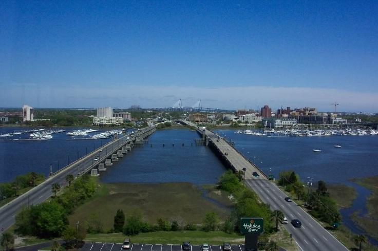
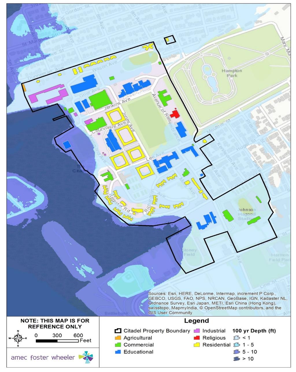
5 Campus Profile Located on the peninsula adjacent to the Ashley River Average campus ground elevation is 10.3 feet above sea level ~2,300 cadets ~1,200 graduate students 78 campus buildings 7 occupancy types Estimated $1Billion in assets
6 Local Data

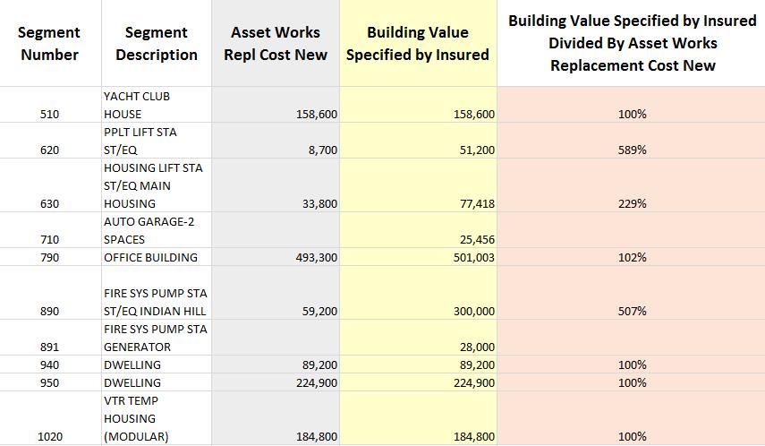
7 Leveraged Data Building Footprints Charleston County Rectified FIRMs City of Charleston 10 ft. LiDAR DEM State of South Carolina Building Replacement Values The Citadel
8 Challenge: Lack of Campus Data

9 Solution: Creation of Campus Base Map
10 Challenge: No Digital FIRM The image cannot be displayed. Your computer may not have enough memory to open the image, or the image may have been corrupted. Restart your computer, and then open the file again. If the red x still appears, you may have to delete the image and then insert it again.

11 Solution: Digitized Flood Layer
12 Hazus Runs


13 Hazus Runs Flood Hurricane Earthquake

14 Assets at Risk *Agricultural building is campus green house
15 Flood Depth/Damage Curve Flood damage is directly related to the depth of flooding by the application of a depth damage curve. In applying the curve, a specific depth of water translates to a specific percentage of damage to the structure, which translates to the same percentage of the structure s replacement value.
16
17 Estimated Damage 100-year Flood Occupancy Type Total Number of Buildings with Loss Total Value (Building & Contents) Estimated Building Damage Estimated Content Loss Estimated Total Damage Loss Ratio Agricultural 1 $110,780 $0 $332 $ Commercial 9 $129,111,580 $84,463 $914,858 $999, Education 7 $226,466,590 $405,174 $3,621,956 $4,027, Government 0 N/A N/A N/A N/A N/A Industrial 3 $17,292,275 $6,917 $0 $6, Religious 0 N/A N/A N/A N/A N/A Residential 28 $90,471,893 $525,685 $210,274 $735, Total 48 $463,453,118 $1,022,239 $4,747,420 $5,769,

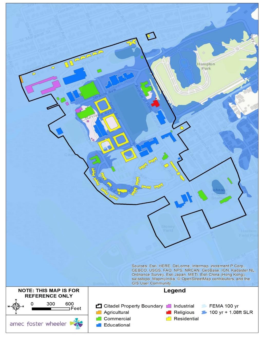
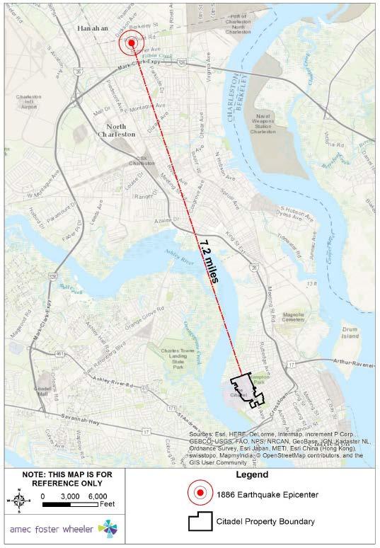
18 Sea Level Rise To determine the specific variation in loss estimates based on flood severity and sea level rise, impacts of coastal flooding were assessed using Hazus and the impact of the 100-year coastal flood on the Citadel campus with 1.08 feet of sea level rise (expected by 2050).
19

20 Facility Name LESESNE GATE & GATEHOUSE LEE ST. MARY MURRAY INFIRMARY BOAT CTR LIFT STA ST/EQ INFIRMARY GENERATOR HAMMOND AVE CENTRAL ENERGY PLANT Fire Station Police Station X Facility Type EMS X Pump Station X Utility Total X X
21 Estimated Damage 100-year Flood FT SLR Occupancy Type Total Number of Buildings with Loss Total Value (Building & Contents) Estimated Building Damage Estimated Content Loss Estimated Total Damage Loss Ratio Agricultural 1 $110,780 $13,521 $36,503 $50, Commercial 14 $261,094,925 $8,241,715 $43,971,779 $52,213, Education 15 $457,173,115 $8,931,882 $78,493,014 $87,424, Government 0 N/A N/A N/A N/A N/A Industrial 5 $20,445,100 $2,169,998 $6,267,692 $8,437, Religious 1 $17,170,400 $0 $432,710 $432, Residential 33 $150,929,693 $7,420,844 $4,692,606 $12,113, Total 69 $906,924,013 $26,777,959 $133,894,303 $160,672,

22 Hurricane Wind On September 22, 1989, Hurricane Hugo roared ashore just north of Charleston, S.C. as a massive Category 4 storm with winds near 140 mph and a storm tide around 20 feet.
23 Estimated Damage Hurricane Hugo Event Total Value Total Number of Buildings Occupancy Type (Building & Contents) Minor Moderate Severe Complete Agricultural $110, Commercial $264,190, Education $500,379, Government $ Industrial $26,842, Religious $19,264, Residential $200,563, Total $1,011,352,

24 Storm Surge Surge Category Number of Buildings Affected Category 1 10 Category 2 58 Category 3 78

25 1886 Earthquake Event 7.3 Magnitude 60 deaths 2,000 damaged buildings $5-6M Felt as far as Boston, MA and New Orleans, LA "Citadel, Charleston, looking north." The earthquake caused serious damage to The Citadel, The Military College of South Carolina, which dates from The view in this Howland photograph is from Marion Square, between King and Meeting streets looking north. (South Carolina Library Archives)
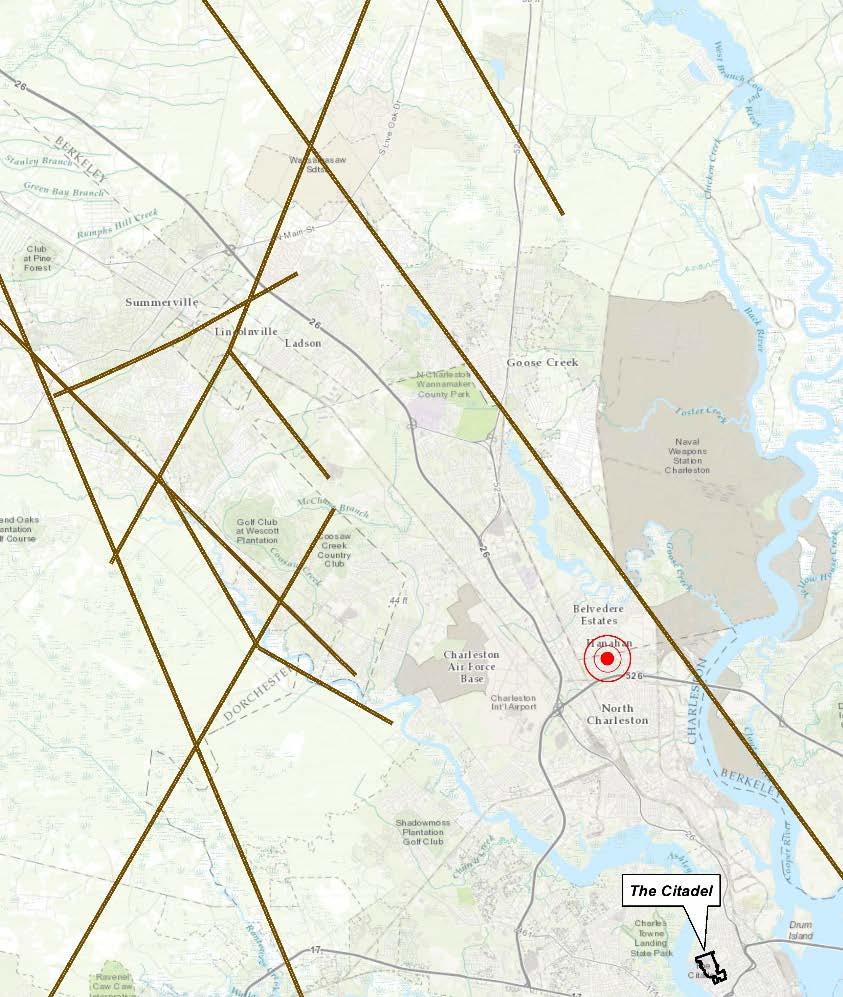
26 Charleston Area Fault Lines
27 Estimated Damage 1886 Earthquake Event Occupancy Type Total Number of Buildings with Losses Total Value (Building & Contents) Estimated Total Damage Estimated Loss Ratio Agricultural 1 $110,780 $54, Commercial 15 $266,243,445 $124,033, Education 18 $535,099,265 $211,943, Government 0 $0 $ Industrial 8 $23,681,450 $9,338, Religious 2 $19,264,960 $10,365, Residential 34 $200,563,628 $108,949, Total 78 $1,044,963,528 $464,685,

28 Mitigation Strategy
29 Mitigation Actions Develop GIS Capabilities Action Develop a system to ensure that new students, faculty, and staff are exposed to basic all-hazards preparedness training during orientation activities. Improve/upgrade stormwater drainage features Conduct survey of all campus facilities that store hazardous materials to identify non-structural components (i.e. shelving and storage areas) that may be vulnerable to earthquake damage. Hazards Addressed All Hazards All Hazards Flood Earthquake

30 30
PHASE 2 HAZARD IDENTIFICATION AND RISK ASSESSMENT
 Prioritize Hazards PHASE 2 HAZARD IDENTIFICATION AND After you have developed a full list of potential hazards affecting your campus, prioritize them based on their likelihood of occurrence. This step
Mapping Flood Risk in the Upper Fox River Basin:
 Mapping Flood Risk in the Upper Fox River Basin: Vulnerable Populations and Adverse Health Effects Presented by: Angelina Hanson STUDY AREA: Wisconsin's Upper Fox River Basin Total Population 139,309.
Overview of HAZUS. December 6, 2011
 Overview of HAZUS December 6, 2011 What is HAZUS? Risk assessment tool for analyzing potential losses from hurricane, flood, and earthquake Uses current scientific and engineering concepts in a GIS to
RISK MANAGEMENT NEXT GENERATION
 RISK MANAGEMENT NEXT GENERATION STATE UPDATE July 2014 Marc Stanard / John Dorman Risk Management Key Components and National Status Risk Monitoring No digital tracking Big Elephant to Track Not Tied to
AIR Worldwide Analysis: Exposure Data Quality
 AIR Worldwide Analysis: Exposure Data Quality AIR Worldwide Corporation November 14, 2005 ipf Copyright 2005 AIR Worldwide Corporation. All rights reserved. Restrictions and Limitations This document may
Emergency Management. December 16, 2010
 Applications of Hazus-MH for Emergency Management December 16, 2010 What is Hazus-MH? Free ArcGIS extension Facilitates a risk-based approach to mitigation Identifies and visually displays hazards and
Planning for SLR Resiliency in Virginia Beach
 Old Dominion University ODU Digital Commons May 18, 2016: The Economic Impacts of Sea-Level Rise in Hampton Roads Hampton Roads Intergovernmental Pilot Project: Meetings 5-18-2016 Planning for SLR Resiliency
ANNEX B: TOWN OF BLUE RIVER
 ANNEX B: TOWN OF BLUE RIVER B.1 Community Profile Figure B.1 shows a map of the Town of Blue River and its location within Summit County. Figure B.1. Map of Blue River Summit County (Blue River) Annex
Volusia County Floodplain Management Plan 2012
 Volusia County Floodplain Management Plan 2012 Introduction The National Flood Insurance Program (NFIP) provides federally supported flood insurance in communities that regulate development in floodplains.
Step 3: Adaptation Planning & Design. Logan Airport
 Step 3: Adaptation Planning & Design Logan Airport Terminal A Satellite Doors to Harborside Substation CAT. 3 HURRICANE (MHHW) FLOOD EL. = 20.75 CAT. 2 HURRICANE (HAT) EST. FLOOD EL. = 18.42 CAT. 2 HURRICANE
Georgia Silver Jackets Team
 Georgia Silver Jackets Team 9 th Annual GAFM Technical Conference Jeff Morris GA SJ Collaborator Savannah District, USACE US Army Corps of Engineers SMART GOVERNMENT Integrate and synchronize flood risk
TREASURE COAST REGIONAL PLANNING COUNCIL M E M O R A N D U M. To: Council Members AGENDA ITEM 7C4
 TREASURE COAST REGIONAL PLANNING COUNCIL M E M O R A N D U M To: Council Members AGENDA ITEM 7C4 From: Date: Subject: Staff September 16, 2016 Council Meeting Local Government Comprehensive Plan Review
VULNERABILITY ASSESSMENT
 SOUTHSIDE HAMPTON ROADS HAZARD MITIGATION PLAN VULNERABILITY ASSESSMENT INTRODUCTION The Vulnerability Assessment section builds upon the information provided in the Hazard Identification and Analysis
Overview of HAZUS for Earthquake Loss Estimation. September 6, 2012
 Overview of HAZUS for Earthquake Loss Estimation September 6, 2012 What is HAZUS? Risk assessment tool for analyzing potential losses from hurricane, flood, and earthquake Uses current scientific and engineering
9.10 HEIDELBERG TOWNSHIP
 9.10 HEIDELBERG TOWNSHIP This section presents the jurisdictional annex for Heidelberg Township. A. HAZARD MITIGATION PLAN POINT OF CONTACT Name Title/ Department Address Telephone Fax Email Primary Point
Integrating Hazus into the Flood Risk Assessment
 Integrating Hazus into the Flood Risk Assessment GAFM Conference, March 22, 2016 Mapping Assessment Planning Agenda What is Hazus & Risk Assessment? Census Block vs. Site Specific Analysis User Defined
Crediting Adaptation Strategies through the National Flood Insurance Program s Community Rating System Coordinator s Manual
 Crediting Adaptation Strategies through the National Flood Insurance Program s Community Rating System Coordinator s Manual W. Thomas Hawkins, Adjunct Faculty, University of Florida, Levin College of Law
REQUEST FOR PROPOSALS. Planning in Water s Way: Flood Resilient Economic Development Strategy for the I-86 Innovation Corridor
 REQUEST FOR PROPOSALS Planning in Water s Way: Flood Resilient Economic Development Strategy for the I-86 Innovation Corridor Southern Tier Central Regional Planning and Development Board (STC) is seeking
Survey of Hazus-MH: FEMA s Tool for Natural Hazard Loss Estimation
 Survey of Hazus-MH: FEMA s Tool for Natural Hazard Loss Estimation What is Hazus? Software tools and support system designed by FEMA for the purpose of providing communities with the means to identify
Sussex County All Hazard Mitigation Plan. Plan Executive Summary
 Sussex County All Hazard Mitigation Plan Plan Executive Summary March 2010 SUSSEX COUNTY ALL HAZARD MITIGATION PLAN SUMMARY March 2010 For questions and to make comments on this document, contact: Joseph
Adaptation Practices and Lessons Learned
 Adaptation Practices and Lessons Learned Increased Flooding Risk Due To Sea Level Rise in Hampton Roads: A Forum to Address Concerns, Best Practices and Plans for Adaptation Nov. 16, 2012 Virginia Modeling,
Flood Risk Assessment in the
 Georgia Flood M.A.P. Program Flood Risk Assessment in the Upper Chattahoochee h h River Basin GAFM Annual Conference March 28, 2012 Agenda Map Mod to Risk MAP (Georgia Flood M.A.P.) transition Flood Risk
Simsbury. Challenges Capitol Region Natural Hazards Mitigation Plan Update - Page 356
 Simsbury Simsbury is a suburban community of about 23,600 located in the western portion of the Capitol Region. Its land area encompasses 33.9 square miles. Elevation in town generally ranges from about
Canada s exposure to flood risk. Who is affected, where are they located, and what is at stake
 Canada s exposure to flood risk Who is affected, where are they located, and what is at stake Why a flood model for Canada? Catastrophic losses Insurance industry Federal government Average industry CAT
Using GISWeb to Determine Your Property s Flood Zone
 Using GISWeb to Determine Your Property s Flood Zone 1. In a new browser window, go to http://www.co.santacruz.ca.us/departments/geographicinformationsystemsgis.aspx 2. Click on GISWeb - GIS Mapping Application
3D Elevation Program (3DEP) Status and Plans. Kevin T. Gallagher Associate Director, Core Science Systems June 26, 2017
 Status and Plans. Kevin T. Gallagher Associate Director, Core Science Systems June 26, 2017") + 3D Elevation Program (3DEP) Status and Plans Kevin T. Gallagher Associate Director, Core Science Systems June 26, 2017 + 2 3D Elevation Program (3DEP) Apply lidar technology to map bare earth and 3D
+ 3D Elevation Program (3DEP) Status and Plans Kevin T. Gallagher Associate Director, Core Science Systems June 26, 2017 + 2 3D Elevation Program (3DEP) Apply lidar technology to map bare earth and 3D
Repetitive Loss Area Revisit # 6 Walter Road Area Jefferson Parish
 Repetitive Loss Area Revisit # 6 Walter Road Area Jefferson Parish www.floodhelp.uno.edu Supported by FEMA Acknowledgement The compilation if this report was managed by Erin Patton, CFM, a UNO-CHART Research
Challenges. Estimated Damages from 100-Year Flood
 Newington Newington is a fully suburban town in central Connecticut with a population of about 30,562. The Town encompasses 13.2 square miles and ranges in elevation from 40-350 feet above sea level. The
National Capitol Region HAZUS User Group Call
 Listen to the recording here to follow along with the presentation: http://www.freeconferencecalling.com/recordings/recording.aspx?fileid=l AF3494_04252013070630062_1154707&bridge=697620&email=&account
THE POTENTIAL ROLE OF THE COMMUNITY FOR THE FLOOD RISK ASSESSMENT USING FEATURES EXTRACTED FROM LiDAR DATASETS
 THE POTENTIAL ROLE OF THE COMMUNITY FOR THE FLOOD RISK ASSESSMENT USING FEATURES EXTRACTED FROM LiDAR DATASETS Gus Kali Oguis 1, Dr. Genelin Ruth P. James 1, Cinmayii G. Manliguez 1,2, Christine Lou Adino
Hazus: Estimated Damage and Economic Losses. South Carolina United States
 Hurricane Florence Advisory 61, 14 September 2018 1100 EST (1500Z) Hazus: Estimated Damage and Economic Losses United States Caution: Due to the level of uncertainty associated with the current advisory
Garfield County NHMP:
 Garfield County NHMP: Introduction and Summary Hazard Identification and Risk Assessment DRAFT AUG2010 Risk assessments provide information about the geographic areas where the hazards may occur, the value
9.8 FOUNTAIN HILL BOROUGH
 9.8 FOUNTAIN HILL BOROUGH This section presents the jurisdictional annex for Fountain Hill Borough. A. HAZARD MITIGATION PLAN POINT OF CONTACT Name Title/ Department Address Telephone Fax Email Primary
Aquidneck Island Resilience Strategy Issue Paper 4. Issue: RESIDENTIAL FLOODING
 Aquidneck Island Resilience Strategy Issue Paper 4 Issue: RESIDENTIAL FLOODING Description of Concern: While much of Aquidneck Island s geography lies outside the reach of coastal flooding, some of the
Coastal Vulnerability Assessment and Adaptation Plan CITY OF CLEARWATER
 Coastal Vulnerability Assessment and Adaptation Plan 1 Background Vulnerability Assessment Adaptation Plan Peril of Flood Grant 2 Background SEA LEVEL RISE ADAPTATION PROJECT This publication was funded
Talk Components. Wharton Risk Center & Research Context TC Flood Research Approach Freshwater Flood Main Results
 Dr. Jeffrey Czajkowski (jczaj@wharton.upenn.edu) Willis Research Network Autumn Seminar November 1, 2017 Talk Components Wharton Risk Center & Research Context TC Flood Research Approach Freshwater Flood
Storm Surge Risk and Sea-Level Rise: What the Future May Hold.
 Storm Surge Risk and Sea-Level Rise: What the Future May Hold. Presented by Tom Jeffery Sr. Hazard Scientist, CoreLogic Storm Surge Risk to Residential Properties 4.2 million (Gulf Coast and East Coast)
Tsunami Risk Assessment Tsunami Hazard Overview... 16
 Risk Report (DRAFT) For Grays Harbor County including the Cities of Aberdeen, Cosmopolis, Hoquiam, Ocean Shores, Westport, Montesano, McCleary, Elma, and Oakville October 9, 2014 Table of Contents 1. Introduction...
Individual Flood Preparedness Decisions During Hurricane Sandy in New York City By prof.dr. Wouter Botzen
 Individual Flood Preparedness Decisions During Hurricane Sandy in New York City By prof.dr. Wouter Botzen Agenda 1. Context: Individual adaptation measures in flood risk management 2. Flood risk management
Gerard S. Mallet, Local Mitigation Strategy Coordinator FLOODPLAIN MANAGEMENT PLAN PROGRESS REPORT
 Date: September 10, 2009 To: From: Subject: Charlotte County Board of County Commissioners Gerard S. Mallet, Local Mitigation Strategy Coordinator FLOODPLAIN MANAGEMENT PLAN PROGRESS REPORT Resolution
National Capitol Region HAZUS User Group Call
 Click here to listen to the audio. National Capitol Region HAZUS User Group Call June 28, 2017 11:00 AM ET NCR HUG Call Details Conference Call Details: 1. Dial-in: 1-712-770-8023 2. Conference code: 926757
HAZUS -MH Risk Assessment and User Group Series HAZUS-MH and DMA Pilot Project Portland, Oregon. March 2004 FEMA FEMA 436
 HAZUS -MH Risk Assessment and User Group Series HAZUS-MH and DMA 2000 Pilot Project Portland, Oregon March 2004 FEMA FEMA 436 Page intentionally left blank. Risk Assessment Pilot Project Results for DMA
SECTION 3: VULNERABILITY ASSESSMENT
 SECTION 3: VULNERABILITY ASSESSMENT This section provides an assessment the potential impact the various hazards to which Manatee County is vulnerable. The first objective this section is to identify the
Establishing an Essential Records List Criteria and Reporting Essential Records to the University s Records Management and Archives Department
 Establishing an Essential Records List Criteria and Reporting Essential Records to the University s Records Management and Archives Department December, 2015 ESTABLISHING AN ESSENTIAL RECORDS LIST What
Mitigation Success Publications
 The following publications are a sample of the many and varied documents that have been produced by States, associations and communities. MULTI-HAZARDS FEMA 294 Report on Costs and Benefits of Natural
Truckloads (at 25 tons/truck) of building debris 90
 of building debris 90") Marlborough Marlborough is a rural community in Hartford County covering a land area of 23.3 square miles and with an estimated population of 6,410. Elevation ranges from about 160 to 800 feet. The Town
Marlborough Marlborough is a rural community in Hartford County covering a land area of 23.3 square miles and with an estimated population of 6,410. Elevation ranges from about 160 to 800 feet. The Town
Leveraging HAZUS for Risk Assessment Analysis within Risk MAP
 Leveraging HAZUS for Risk Assessment Analysis within Risk MAP Jen Meyer - FEMA Region X Shane Parson - RAMPP PTS Team (URS Corp.) 2010 HAZUS Conference - August 2010 The Paradigm Shift: Map Mod to Risk
NFIP Program Basics. KAMM Regional Training
 NFIP Program Basics KAMM Regional Training Floodplain 101 Homeowners insurance does not cover flood damage Approximately 25,000 flood insurance policies in KY According to BW12 analysis, approximately
Mike Waters VP Risk Decision Services Bob Shoemaker Sr. Technical Coordinator. Insurance Services Office, Inc
 Mike Waters VP Risk Decision Services Bob Shoemaker Sr. Technical Coordinator Insurance Services Office, Inc Disasters Large and Small A Convergence of Interests Public and Private ESRI Homeland Security
Executive Summary... 2 Introduction and Study Context... 4 Flood Vulnerability Assessment... 9 Study Caveats Conclusions...
 Executive Summary... 2 Introduction and Study Context... 4 Talbot y s Floodplain... 4 Flood Measurement... 5 Flood Levels... 6 Hazards from Floods... 7 Flood Vulnerability Assessment... 9 Study Method...
9.2 ALBURTIS BOROUGH. This section presents the jurisdictional annex for Alburtis Borough. A. HAZARD MITIGATION PLAN POINT OF CONTACT
 9.2 ALBURTIS BOROUGH This section presents the jurisdictional annex for Alburtis Borough. A. HAZARD MITIGATION PLAN POINT OF CONTACT Name Title/ Department Address Telephone Fax Email Primary Point of
Northern Kentucky University 2018 Hazard Mitigation Plan. Public Kick-Off Meeting March 20, 2018
 Northern Kentucky University 2018 Hazard Mitigation Plan Public Kick-Off Meeting March 20, 2018 Agenda Welcome Hazard Mitigation Planning 101 Hazard Identification Exercises Next Steps Jeff Baker, NKU
Multi-Jurisdictional Hazard Mitigation Plan. Data Collection Questionnaire. For Local Governments
 Multi-Jurisdictional Hazard Mitigation Plan Data Collection Questionnaire County: For Local Governments Jurisdiction: Return to: Marcus Norden, Regional Planner BRP&EC Please complete this data collection
David A. Stroud, CFM AMEC Earth & Environmental Raleigh, NC
 David A. Stroud, CFM AMEC Earth & Environmental Raleigh, NC Objectives Risk MAP background North Carolina s Risk MAP role Role of communication in Risk MAP Effective risk communication two examples Multi-hazard
Avon. Challenges. Estimated Damages from 100- Year Flood
 Avon Avon is a suburban town in north-central Connecticut with a population of about 18,000. It has an average elevation of about 350 ft. The Town encompasses 23.5 square miles, lying entirely within the
GIS - Introduction and Sample Uses
 PDHonline Course L145 (5 PDH) GIS - Introduction and Sample Uses Instructor: Jonathan Terry, P.L.S. 2012 PDH Online PDH Center 5272 Meadow Estates Drive Fairfax, VA 22030-6658 Phone & Fax: 703-988-0088
A Flood Mitigation Plan for the Non-Tidal N.J. Section of the Delaware River Basin. Warren County Planning Workshop (2 nd Meeting) March 7, 2007
 March 7, 2007") A Flood Mitigation Plan for the Non-Tidal N.J. Section of the Delaware River Basin Warren County Planning Workshop (2 nd Meeting) March 7, 2007 Study Area Participation: Hunterdon: 16 Eligible Municipalities
A Flood Mitigation Plan for the Non-Tidal N.J. Section of the Delaware River Basin Warren County Planning Workshop (2 nd Meeting) March 7, 2007 Study Area Participation: Hunterdon: 16 Eligible Municipalities
Multi-Jurisdictional Hazard Mitigation Plan. Data Collection Questionnaire. For School Districts and Educational Institutions
 Multi-Jurisdictional Hazard Mitigation Plan Data Collection Questionnaire For School Districts and Educational Institutions County: School District / Educational Institution Name: Return by: Please complete
Flood Vulnerability Assessment for Critical Facilities. Molly Woloszyn Lisa Graff, GISP, CFM
 Flood Vulnerability Assessment for Critical Facilities Molly Woloszyn Lisa Graff, GISP, CFM 2011 University of Illinois Board of Trustees. All rights reserved. For permission information, contact the Illinois
HAZARD MITIGATION PLAN POINT OF CONTACT MUNICIPAL PROFILE
 HAZARD MITIGATION PLAN POINT OF CONTACT louise@windgap-pa.gov jeffreyyob@gmail.com MUNICIPAL PROFILE MUNICIPAL PARTICIPATION Compliance with the National Flood Insurance Program (NFIP) Identify source
HAZARD MITIGATION PLAN POINT OF CONTACT MUNICIPAL PROFILE
 HAZARD MITIGATION PLAN POINT OF CONTACT lee.laubach@allentownpa.gov james.wehr@allentownpa.gov MUNICIPAL PROFILE MUNICIPAL PARTICIPATION Compliance with the National Flood Insurance Program (NFIP) 1. Staff
Executive Summary Introduction and Study Context Cecil County s Floodplain Flood Measurement Flood Levels...
 Executive Summary... 2 Introduction and Study Context... 4 Cecil y s Floodplain... 4 Flood Measurement... 6 Flood Levels... 6 Hazards from Floods... 7 Flood Vulnerability Assessment... 9 Study Method...
Development of an Integrated Simulation Model for Flood Risk Evaluation and Damage Assessment
 Development of an Integrated Simulation Model for Flood Risk Evaluation and Damage Assessment presented by Professor Emeritus Charng Ning CHEN School of Civil & Environmental Engineering (CEE), and Principal
Community Incentives for Nature-Based Flood Solutions
 Community Incentives for Nature-Based Flood Solutions A GUIDE TO FEMA S COMMUNITY RATING SYSTEM FOR CONSERVATION PRACTITIONERS The Federal Emergency Management Agency (FEMA) uses a Community Rating System
Flood: How to Protect Your Business from a Natural Disaster
 Flood: How to Protect Your Business from a Natural Disaster Speakers: Greg Bates, Managing Consultant, Global Risk Consultants (GRC) Frank Francone, Manager, Insurance & Risk Services, General Growth Properties
East Hartford. Challenges
 East Hartford The Town of East Hartford is a suburban community of approximately 52,212 located east of the City of Hartford and west of the Town of Manchester. The Town covers slightly more than 18 square
City of Ocean City Permit and Application Process Quality Improvement
 Introduction. This report embodies a thorough evaluation of Ocean City s land use approval and development permitting procedures. Specific reference is made to application requirements and administrative
G318 Local Mitigation Planning Workshop. Module 2: Risk Assessment. Visual 2.0
 G318 Local Mitigation Planning Workshop Module 2: Risk Assessment Visual 2.0 Unit 1 Risk Assessment Visual 2.1 Risk Assessment Process that collects information and assigns values to risks to: Identify
SECTION V THE LOCAL MITIGATION STRATEGY BLUEPRINT
 SECTION V THE LOCAL MITIGATION STRATEGY BLUEPRINT A. GUIDING MITIGATION PRINCIPLES The Local Mitigation Strategy (LMS) is Hillsborough County s program developed to reduce or eliminate all forms of losses
Town of Montrose Annex
 Town of Montrose Annex Community Profile The Town of Montrose is located in the Southwest quadrant of the County, east of the Town of Primrose, south of the Town of Verona, and west of the Town of Oregon.
Section 2. Introduction and Purpose of the LMS
 Section 2. Introduction and Purpose of the LMS 2.1 Introduction The Disaster Mitigation Act of 2000 (DMA 2000), signed into law by the President of the United States on October 30, 2000 (P.L. 106-390),
CHAPTER THREE Natural Hazard Mitigation Strategy
 CHAPTER THREE Natural Hazard Mitigation Strategy Chapter 3 Section All Sections Updates to Section Revised Natural Hazards Introduction and all Sections to change Natural Hazards Subcommittee to Committee.
HAZARD DESCRIPTION... 1 LOCATION... 2 EXTENT... 4 HISTORICAL OCCURRENCES... 6 PROBABILITY OF FUTURE EVENTS... 6 VULNERABILITY AND IMPACT...
 DAM FAILURE HAZARD DESCRIPTION... 1 LOCATION... 2 EXTENT... 4 HISTORICAL OCCURRENCES... 6 PROBABILITY OF FUTURE EVENTS... 6 VULNERABILITY AND IMPACT... 6 Hazard Description Dams are water storage, control
Flood Risk Management and Nonstructural Flood Risk Adaptive Measures
 Flood Risk Management and Nonstructural Flood Risk Adaptive Measures Randall Behm, P.E., CFM USACE-Omaha District Chair, National Nonstructural Flood Proofing Committee US Army Corps of Engineers BUILDING
Non Regulatory Risk MAP Products Flood Depth and Probability Grids
 Non Regulatory Risk MAP Products Flood Depth and Probability Grids Virginia Floodplain Management Association 2015 Floodplain Management Workshop October 29th, 2015 Nabil Ghalayini, P.E., PMP, D.WRE, CFM
Michael Taylor, PE, CFM Project Manager, AECOM August 25, 2015
 Promoting FEMA s Flood Risk Products in the Lower Levisa Watershed Michael Taylor, PE, CFM Project Manager, AECOM August 25, 2015 Agenda Study Background Flood Risk Product Overview AOMI and Mitigation
Location: Tampa, Florida March 6, 2013
 Discovery Meeting: West Florida Coastal Study Location: Tampa, Florida March 6, 2013 Agenda Introductions Why we are here Outline Risk MAP products and datasets Discovery Overview: Project scoping and
SILVER JACKETS: TEAMING TO MITIGATE AND MANAGE STATE FLOOD HAZARD PRIORITIES
 SILVER JACKETS: TEAMING TO MITIGATE AND MANAGE STATE FLOOD 255 255 255 237 237 237 0 0 0 217 217 217 163 163 163 200 200 200 131 132 122 239 65 53 80 119 27 HAZARD PRIORITIES 110 135 120 252 174.59 112
FLOOD INUNDATION MAPPING SCIENCE. Gardner Bent, U.S. Geological Survey, New England Water Science Center
 FLOOD INUNDATION MAPPING SCIENCE Gardner Bent, U.S. Geological Survey, New England Water Science Center What is Flood Inundation Mapping? Flood Inundation Mapping (FIM) is a real-time, operational tool
Wildfire and Flood Hazards, Using GIS Tools to Assess Risk
 Wildfire and Flood Hazards, Using GIS Tools to Assess Risk Floodplain Management Association Conference, Rancho Mirage, CA September 2015 Thoughts To Keep In Mind What advantages are there in looking at
Sea Level Rise and the NFIP
 Cheryl A Johnson, PE, CFM, PMP March 26, 2014 http://www.globalchange.gov/ Sea-level rise and the likely increase in hurricane intensity and associated storm surge will be among the most serious consequences
HAZARD MITIGATION PLAN POINT OF CONTACT MUNICIPAL PROFILE
 HAZARD MITIGATION PLAN POINT OF CONTACT northcatasauquaema@yahoo.com scheirerg@gmail.com MUNICIPAL PROFILE MUNICIPAL PARTICIPATION Compliance with the National Flood Insurance Program (NFIP) Identify source
Mitigation Action Plan Alamance County
 Mitigation Action Plan Alamance County The Mitigation Action Plan for Alamance County is divided into two subsections: 7.1 Status of Previously Adopted Mitigation Actions 7.2 New 2015 Mitigation Actions
Pinellas County Local Mitigation Strategy Progress Report
 Date: April 22, 2018 To: From: Subject: City of Commissioners Joseph A. DiPasqua, CBO, CFM, Assistant Director of Planning & Development Progress Report Background, Florida, and its 23 incorporated municipalities
FEMA FLOOD MAPS Public Works Department Stormwater Management Division March 6, 2018
 FEMA FLOOD MAPS Public Works Department Stormwater Management Division March 6, 2018 Presentation Overview FEMA National Flood Insurance Program (NFIP) FEMA Community Rating System (CRS) Flood Insurance
National Institute of Building Sciences
 National Institute of Building Sciences Provider Number: G168 Improving the Flood Resistance of Buildings and Mitigation Techniques WE3B Peter Spanos, P.E., CFM, LEED AP (Gale Associates, Inc.) Stuart
2015 AWRA Summer Specialty Conference: Climate Change Adaptation (New Orleans, LA) June 15, 2015 Presenter: John Squerciati, P.E.
 June 15, 2015 Presenter: John Squerciati, P.E.") Economic Assessment Tools for Infrastructure Resilience Projects - FTA - Hazard Mitigation Cost Effectiveness (HMCE) Tool and Recurrence Interval Calculator for Benefit-Cost Analysis 2015 AWRA Summer Specialty
Economic Assessment Tools for Infrastructure Resilience Projects - FTA - Hazard Mitigation Cost Effectiveness (HMCE) Tool and Recurrence Interval Calculator for Benefit-Cost Analysis 2015 AWRA Summer Specialty
HAZARD MITIGATION PLAN POINT OF CONTACT. MUNICIPAL PROFILE
 HAZARD MITIGATION PLAN POINT OF CONTACT alacko@walnutportpa.org MUNICIPAL PROFILE MUNICIPAL PARTICIPATION Compliance with the National Flood Insurance Program (NFIP) Topic 1. Staff Resources Is the Community
Public Outreach Strategy
 Public Outreach Strategy The Hillsborough County Public Outreach program is a community wide effort and includes participants from all jurisdictions. This report illustrates a commitment by Hillsborough
HAZARD MITIGATION PLAN POINT OF CONTACT. MUNICIPAL PROFILE
 HAZARD MITIGATION PLAN POINT OF CONTACT washtwpemc@ptd.net MUNICIPAL PROFILE MUNICIPAL PARTICIPATION Compliance with the National Flood Insurance Program (NFIP) Topic 1. Staff Resources Is the Community
September Three Steps for Implementing a Complete Flood Management Plan
 September 2016 Three Steps for Implementing a Complete Flood Management Plan Copyright 2016 Esri All rights reserved. Printed in the United States of America. The information contained in this document
APPENDIX H TOWN OF FARMVILLE. Hazard Rankings. Status of Mitigation Actions. Building Permit Data. Future Land Use Map. Critical Facilities Map
 APPENDIX H TOWN OF FARMVILLE Hazard Rankings Status of Mitigation Actions Building Permit Data Future Land Use Map Critical Facilities Map Zone Maps Hazard Rankings (From Qualitative Assessment and Local
Vision to Action: Creating and Using a Flood Risk Assessment for Identifying Mitigation Options
 Vision to Action: Creating and Using a Flood Risk Assessment for Identifying Mitigation Options Lisa Graff, CFM, GISP Clayton Ballerine, CFM Brad McVay, CFM, GISP University of Illinois Prairie Research
Overview of Capabilities and Current Limitations
 Overview of Capabilities and Current Limitations Overview of the National Flood Risk Characterization Tool (NFRCT) Map based viewer of relative flood risk around the U.S., with supporting reports for more
Disaster Risk Reduction and Financing in the Pacific A Catastrophe Risk Information Platform Improves Planning and Preparedness
 Disaster Risk Reduction and Financing in the Pacific A Catastrophe Risk Information Platform Improves Planning and Preparedness Synopsis The Pacific Islands Countries (PICs) 1, with a combined population
Not Your Average Risk Assessment: Multi-Stage Risk Assessments for Sites in the Passaic River Basin Stuart Geiger, CFM Joseph Ruggeri, PE, CFM
 Not Your Average Risk Assessment: Multi-Stage Risk Assessments for Sites in the Passaic River Basin Stuart Geiger, CFM Joseph Ruggeri, PE, CFM Agenda Project Background Risk Assessment Development Refined
Handout 1.1 Essential Records
 Essential Records Session 1 Handout 1.1 Handout 1.1 Essential Records PRIORITY FOR ACCESS* Priority 1: First 1 12 hours Could be either Priority 1 or Priority 2 Priority 2: First 12 72 hours Priority 2
Federal Emergency Management Agency Update. Jesse F. Munoz, CEM Director Mitigation Division Region IV
 Federal Emergency Management Agency Update Jesse F. Munoz, CEM Director Mitigation Division Region IV To support our citizens and first responders to ensure that as a nation we work together to build,
CAPITAL IMPROVEMENTS ELEMENT:
 CAPITAL IMPROVEMENTS ELEMENT: Goals, Objectives and Policies Goal 1. The provision of needed public facilities in a timely manner, which protects investments in existing facilities, maximizes the use of
Village of Blue Mounds Annex
 Village of Blue Mounds Annex Community Profile The Village of Blue Mounds is located in the southwest quadrant of the County, north of the town of Perry, west of the town of Springdale, and south of the