FURTHER TO EXECUTIVE COMMITTEE MEETING #13/11 To be held on Friday, February 3, 2012
|
|
|
- Jasper Baldwin
- 5 years ago
- Views:
Transcription
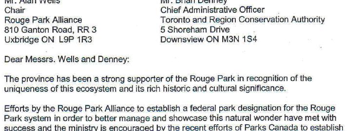
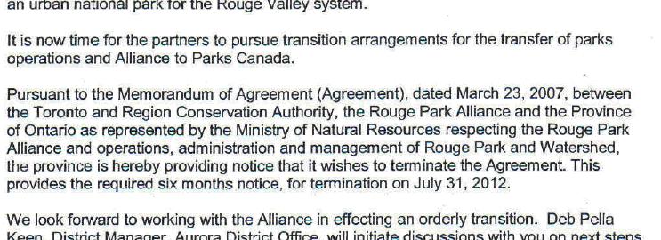
1 FURTHER TO EXECUTIVE COMMITTEE MEETING #13/11 To be held on Friday, February 3, 2012 FURTHER TO: Pages EX6. CORRESPONDENCE EX6.1 A letter dated January 11, 2012 from Mr. David de Launay, Assistant Deputy Minister, Regional Operations Division, Ministy of Natural Resources, in regard to Rouge Park Memorandum of Understanding dated March 23, EX8. SECTION II - ITEMS FOR EXECUTIVE ACTION EX8.3 - TO BE DISTRIBUTED IN ADVANCE OF THE MEETING EX8.3 CLIMATE CHANGE AND WATER RESOURCES: NATIONAL WATER ADAPTATION GUIDANCE BEST PRACTICES COMPENDIUM Award of Contract Report to Follow EX10. APPLICATION FOR PERMITS UNDER ONTARIO REGULATION 166/06 Development, Interference with Wetlands and Alterations to Shorelines and Watercourses ERRATA UPDATE SHEET 99 PERMIT APPLICATION EX10.42 IS A MAJOR APPLICATION TOWN OF MARKHAM EX10.42 TOWN OF MARKHAM To construct, reconstruct, erect or place a building or structure, site grade, temporarily or permanently place, dump or remove any material, originating on the site or elsewhere and alter a watercourse east of Bay Thorn Drive and Yonge Street, in the Town of Markham, Don River watershed as located on the property owned by the Town of Markham. The purpose is to construct a pedestrian bridge over the existing asphalt pathway, removal of three corrugated steel pipe (CSP) culverts and replace with a pool rifle sequence, removal of headwall and weir structure, enhance riparian vegetation and rehabilitate the eroded banks in order to mitigate the associated erosion in Pomona Mills Creek. The Ministry of Natural Resources (MNR) warm water fisheries timing window will apply unless otherwise specified in writing by MNR. A Letter of Advice will be written by TRCA staff on behalf of Fisheries and Oceans Canada (DFO) for this project. 103
2 TOWN OF RICHMOND HILL EX10.43 TOWN OF RICHMOND HILL To construct, reconstruct, erect or place a building or structure, temporarily or permanently place, dump or remove any material, originating on the site or elsewhere and alter a watercourse near Loyal Blue Crescent, southeast of Yonge Street and Gamble Road in the Town of Richmond Hill, Rouge River watershed as located on the property owned by Town of Richmond Hill. The purpose is to replace a failed culvert and walkway with a 10m long pedestrian bridge, including rehabilitation of the creek channel. The Ministry of Natural Resources (MNR) Redside Dace fisheries timing window will apply to this project unless otherwise specified in writing by MNR. A Letter of Advice will be written by TRCA staff on behalf of Fisheries and Oceans Canada (DFO). 105
3 CORRESPONDENCE EX6.1 98
4 EX10 APPLICATION FOR PERMITS UNDER ONTARIO REGULATION 166/06 Development, Interference with Wetlands and Alterations to Shorelines and Watercourses Information has been received and reviewed by staff for the following Scheduled Errata items. The recommendations within the staff reports should be amended to include the following: EX10.17 CALI/BELLISSIMO Letter of Undertaking, prepared by M. Yarranton, KLM Planning Partners Inc., dated January 31, 2012, to address outstanding engineering related concerns. EX10.18 SUNDIAL HOMES (CASTLEMORE) LIMITED Letter of Undertaking, prepared by D. Horgan, Candevcon Limited, dated January 31, 2012, to address outstanding engineering and ecology concerns. EX10.19 QUALITY SEEDS General Notes, Drawing No. G-1, prepared by Urban Ecosystems Limited, Revision No. 1 (revise dated December 22, 2011), received by TRCA on December 23, 2011; General Plan, Drawing No. G-2, prepared by Urban Ecosystems Limited, Revision No. 1 (revise dated December 22, 2011), received by TRCA on December 23, 2011; Storm Drainage Area Plan, Drawing No. G-3, prepared by Urban Ecosystems Limited, Revision No. 1 (revise dated December 22, 2011), received by TRCA on December 23, 2011; Huntington Road, From Sta to Sta , Drawing No. P-1, prepared by Urban Ecosystems Limited, Revision No. 1 (revise dated December 22, 2011), received by TRCA on December 23, 2011; Huntington Road, From Sta to Sta , Drawing No. P-2, prepared by Urban Ecosystems Limited, Revision No. 1 (revise dated December 22, 2011), received by TRCA on December 23, 2011; Langstaff Road, From Sta to Sta , Drawing No. P-3, prepared by Urban Ecosystems Limited, Revision No. 1 (revise dated December 22, 2011), received by TRCA on December 23, 2011; Langstaff Road, From Sta to Sta , Drawing No. P-4, prepared by Urban Ecosystems Limited, Revision No. 1 (revise dated December 22, 2011), received by TRCA on December 23, 2011; Langstaff Road, From Sta to Sta , Drawing No. P-5, prepared by Urban Ecosystems Limited, Revision No. 1 (revise dated December 22, 2011), received by TRCA on December 23, 2011; Erosion and Sediment Control Plan, Drawing No. EC-1, prepared by Urban Ecosystems Limited, Revision No. 1 (revise dated December 22, 2011), received by TRCA on December 23, EX SENLAC ROAD WITHDRAWN EX MONTRESSOR DRIVE WITHDRAWN 99
5 EX10.22 ROSEDALE GOLF CLUB Drawing No. S1, Failed Plan Layout and Section, prepared by Moon-Matz Ltd., dated January 2012, Revision No. 2, revised on January 23, 2012, received on January 27, 2012; Drawing No. S2, Backing Slope Layout, Section and Specification, prepared by Moon-Matz Ltd., dated January 2012, Revision No. 2, revised on January 23, 2012, received on January 27, 2012, redline revised by TRCA staff on January 31, 2012; Drawing No. S3, Silt Fence Details and Notes, prepared by Moon-Matz Ltd., dated January 2012, Revision No. 2, revised on January 23, 2012, received on January 27, EX10.23 BELL CANADA Drawing 403, V68682, prepared by Netricom, on behalf of Bell Canada, dated Drawing 404, V68682, prepared by Netricom, on behalf of Bell Canada, dated Drawing 405, V68682, prepared by Netricom, on behalf of Bell Canada, dated Drawing 406, V68682, prepared by Netricom, on behalf of Bell Canada, dated Drawing 407, V68682, prepared by Netricom, on behalf of Bell Canada, dated Drawing 408, V68682, prepared by Netricom, on behalf of Bell Canada, dated Drawing 409, V68682, prepared by Netricom, on behalf of Bell Canada, dated Drawing 410, V68682, prepared by Netricom, on behalf of Bell Canada, dated Drawing 416, V68682, prepared by Netricom, on behalf of Bell Canada, dated Drawing 417, V68682, prepared by Netricom, on behalf of Bell Canada, dated Drawing 418, V68682, prepared by Netricom, on behalf of Bell Canada, dated Drawing 419, V68682, prepared by Netricom, on behalf of Bell Canada, dated Drawing 701, V68682, General notes, prepared by Netricom, on behalf of Bell Canada, dated December 05, 2011, received January 03, 2012, redline revised on January 31, 2012; Drawing 702, V68682, Heavy duty silt fence barrier, prepared by Netricom, on behalf of Bell Canada, dated Contingency plan in the event of sedimentation or Frac-out, prepared by Bell Canada, received December 16, EX HIGHWAY 27 Site Plan, prepared by Stel & Geyer Professional Land Surveyors Inc., dated January 11, 2012, received by the TRCA January 26, 2012; Basement Floor Plan, drawing no. P-03, prepared by Mosszen Design Interiors, dated November 23, 2011, received by the TRCA January 16, 2012; 100
6 Ground Floor Plan, drawing no. P-01-R4, prepared by Mosszen Design Interiors, dated November 23, 2011, received by the TRCA January 16, 2012; Second Floor Plan, drawing no. P-02-R4, prepared by Mosszen Design Interiors, dated November 23, 2011, received by the TRCA January 16, 2012; West Elevation, drawing no. E-01, prepared by Mosszen Design Interiors, dated December 2, 2011, received by the TRCA January 16, 2012; South Elevation, drawing no. E-02, prepared by Mosszen Design Interiors, dated December 2, 2011, received by the TRCA January 16, 2012; East Elevation, drawing no. E-03, prepared by Mosszen Design Interiors, dated December 2, 2011, received by the TRCA January 16, 2012; North Elevation, drawing no. E-04, prepared by Mosszen Design Interiors, dated December 2, 2011, received by the TRCA January 16, EX10.25 POLISH ARMY VETERANS ASSOCIATION OF AMERICA Site Plan, Drawing No. A-01, prepared by AIM Engineering, dated January 2012, received by the TRCA January 20, 2012, redline revised to indicate location of sediment control fencing; Structural & Roof Plan, Drawing No. A-02, prepared by AIM Engineering, dated January 2012, received by the TRCA January 24, 2012; Cross Section / Elevation, Drawing No. A-03, prepared by AIM Engineering, dated January 2012, received by the TRCA January 24, EX10.26 PACHINO CONSTRUCTION Revised Drawing 1, Erosion Sediment Control (ESC) Plan, illustrating access route and boreholes, undated, received January 17, 2012; Erosion Sediment Control (ESC) Plan, received January 17, 2012, redlined by TRCA staff to revise fisheries timing window to July 1st to September 15th; Figure 1, Silt Fence Installation Specification, OPSD , received January 17, 2012; Figure 2, SD204, Tree Preservation Specification, prepared by Corporation of the Town fo Ajax, received January 17, 2012; Figure 3, Detail of Temporary Crossing, received January 17, 2012; Figure 4, Coir Matting Installation Specification, received January 17, EX FINNERTY SIDE ROAD Letter of Undertaking, prepared by R. Ogilive, dated January 31, 2012, to address all outstanding TRCA issues. EX10.28 BELL CANADA Drawing 409, V60101, prepared by Netricom, on behalf of Bell Canada, dated December 05, 2011, received December 23, 2012; Drawing 410, V60101, prepared by Netricom, on behalf of Bell Canada, dated December 05, 2011, received December 23, 2012; Drawing 411, V60101, prepared by Netricom, on behalf of Bell Canada, dated December 05, 2011, received December 23, 2012; Drawing 701, V60101, General notes, prepared by Netricom, on behalf of Bell Canada, dated December 05, 2011, received December 23, 2012, redline revised on January 31, 2012; Drawing 702, V60101, Heavy duty silt fence barrier, prepared by Netricom, on behalf of 101
7 Bell Canada, dated December 05, 2011, received December 23, 2012; Contingency plan in the event of sedimentation or Frac-out, prepared by Bell Canada, received December 16, EX10.29 BELL CANADA Drawing 401, V60101, prepared by Netricom, on behalf of Bell Canada, dated December 05, 2011, received December 23, 2011; Drawing 406, V60101, prepared by Netricom, on behalf of Bell Canada, dated December 05, 2011, received December 23, 2011; Drawing 701, V60101, General notes, prepared by Netricom, on behalf of Bell Canada, dated December 05, 2011, December 23, 2011, redline revised on January 31, 2012; Drawing 702, V60101, Heavy duty silt fence barrier, prepared by Netricom, on behalf of Bell Canada, dated December 05, 2011, December 23, 2011; Drill fluid management and contingency plan in the event of sedimentation or Frac-out, prepared by Bell Canada, received January 18, EX10.30 BELL CANADA Drawing 416, V60101, prepared by Netricom, on behalf of Bell Canada, dated Drawing 417, V60101, prepared by Netricom, on behalf of Bell Canada, dated Drawing 418, V60101, prepared by Netricom, on behalf of Bell Canada, dated Drawing 701, V60101, General notes, prepared by Netricom, on behalf of Bell Canada, dated December 05, 2011, received January 03, 2012, redline revised on January 31, 2012; Drawing 702, V60101, Heavy duty silt fence barrier, prepared by Netricom, on behalf of Bell Canada, dated Drill fluid management and contingency plan in the event of sedimentation or Frac-out, prepared by Bell Canada, received January 18, EX CALEDON-KING TOWNLINE SOUTH Site Plan, Drawing No. SK-1, prepared by Cityscape Design Innovation Inc., dated October 2011, received by the TRCA January 17, 2012, redline revised to indicate removal of excess fill material and location of sediment control fencing; Retaining Wall Sections, Drawing No. SK-2, prepared by Cityscape Design Innovation Inc., dated October 2011, received by the TRCA January 17, 2012; Landscape Plan and Retaining Wall Drawing, Drawing No. SK-3, prepared by Cityscape Design Innovation Inc., dated January 2012, received by the TRCA January 31,
8 PERMIT APPLICATION EX10.42 IS A MAJOR APPLICATION TOWN OF MARKHAM EX10.42 TOWN OF MARKHAM To construct, reconstruct, erect or place a building or structure, site grade, temporarily or permanently place, dump or remove any material, originating on the site or elsewhere and alter a watercourse east of Bay Thorn Drive and Yonge Street, in the Town of Markham, Don River watershed as located on the property owned by the Town of Markham. The purpose is to construct a pedestrian bridge over the existing asphalt pathway, removal of three corrugated steel pipe (CSP) culverts and replace with a pool rifle sequence, removal of headwall and weir structure, enhance riparian vegetation and rehabilitate the eroded banks in order to mitigate the associated erosion in Pomona Mills Creek. The Ministry of Natural Resources (MNR) warm water fisheries timing window will apply unless otherwise specified in writing by MNR. A Letter of Advice will be written by TRCA staff on behalf of Fisheries and Oceans Canada (DFO) for this project. The permit will be issued for the period of February 3, 2012 to February 2, 2014 in accordance with the following documents and plans which form part of this permit: Drawing GP A; General Plan, dated December, 2011, received December 22, 2011, prepared by Cole Engineering Limited, on behalf of the Town of Markham; Drawing ES A; Erosion and Siltation Control Plan, dated December, 2011, received December 22, 2011, prepared by Cole Engineering Limited, on behalf of the Town of Markham; Drawing RP A; Restoration Plan, dated August, 2011, received December 22, 2011, prepared by Cole Engineering Limited, on behalf of the Town of Markham; Drawing RM A; Removal Plan, dated December, 2011, received December 22, 2011, prepared by Cole Engineering Limited, on behalf of the Town of Markham; Drawing AP A; Access Plan, dated December, 2011, received December 22, 2011, prepared by Cole Engineering Limited, on behalf of the Town of Markham; 103
9 Drawing PH A; Phasing Plan, dated December, 2011, received December 22, 2011, prepared by Cole Engineering Limited, on behalf of the Town of Markham; Drawing S01; General Notes and Plan, dated November, 2011, received December 22, 2011, prepared by Cole Engineering Limited, on behalf of the Town of Markham; Drawing S02; Elevations, dated November, 2011, received December 22, 2011, prepared by Cole Engineering Limited, on behalf of the Town of Markham; Drawing S03; Retaining Wall and Details, dated November, 2011, received December 22, 2011, prepared by Cole Engineering Limited, on behalf of the Town of Markham; Drawing S04; Abutment Plans & Details, dated November, 2011, received December 22, 2011, prepared by Cole Engineering Limited, on behalf of the Town of Markham; Drawing S05; Bridge Deck Section, dated November, 2011, received December 22, 2011, prepared by Cole Engineering Limited, on behalf of the Town of Markham; Drawing S06; Details, dated July, 2011, received December 22, 2011, prepared by Cole Engineering Limited, on behalf of the Town of Markham. RATIONALE The application was reviewed by staff on the basis of the following information: Proposal: The proposal is to construct a 16m long and 3m wide pedestrian bridge over the existing asphalt pathway and stabilize the stream banks in order to mitigate the associated erosion in Pomona Mills Creek, east of Bay Thorn Drive and west of Brae Drive, Don River watershed in the Town of Markham, Regional Municipality of York. Helical piles will be used to minimize excavation in bridge construction. The works include removal of the existing headwall, construction of three wing walls, removal of three corrugated steel pipe (CSP) culverts and implementation of a pool rifle sequence. Control of Flooding: Minor grading is proposed to achieve positive drainage and to construct the pool riffle sequence. The works are not anticipated to affect the conveyance or storage of flood waters. Pollution: Standard erosion and sediment control measures (coffer dam, double silt fence) will be implemented prior to construction, maintained for the duration, and removed only after the site is stabilized and restored. Erosion and sediment control measures have been provided in accordance with the TRCA Erosion and Sediment Control Guidelines for Urban Construction. Dynamic Beaches: Not applicable Erosion: The works propose to improve slope stability and mitigate the erosion currently being observed at the site. 104
10 Conservation of Land: All in water works will be isolated by constructing a temporary water passage system in accordance with Ontario Provincial Standard Drawing (OPSD ) and near water works will be isolated with sediment and erosion control fencing. All dewatering will be treated and released to the environment at least 30m from the watercourse. With erosion and sedimentation plans in effect, the potential for a harmful alteration, disruption or destruction (HADD) of fish habitat will be mitigated. The Ministry of Natural Resources warm water fisheries timing window (construction to occur between July 1 and March 31) will apply to the works unless otherwise specified in writing by MNR. A Letter of Advice will be written by TRCA staff on behalf of Fisheries and Oceans Canada (DFO) for this project. Plantings The proposed works will include the planting of 31 deciduous trees, 69 shrubs and 4200 live stakes. Policy Guidelines: This proposal is consistent with Section 'Infrastructure and Servicing' of the Toronto and Region Conservation Authority's Valley and Stream Corridor Management Program. CFN: Application #: 0430/10/MARK Report Prepared by: Harsha Gammanpila, extension 5629 For information contact: Harsha Gammanpila, extension 5629 Date: January 31, 2012 TOWN OF RICHMOND HILL EX10.43 TOWN OF RICHMOND HILL To construct, reconstruct, erect or place a building or structure, temporarily or permanently place, dump or remove any material, originating on the site or elsewhere and alter a watercourse near Loyal Blue Crescent, southeast of Yonge Street and Gamble Road in the Town of Richmond Hill, Rouge River watershed as located on the property owned by Town of Richmond Hill. The purpose is to replace a failed culvert and walkway with a 10m long pedestrian bridge, including rehabilitation of the creek channel. The Ministry of Natural Resources (MNR) Redside Dace fisheries timing window will apply to this project unless otherwise specified in writing by MNR. A Letter of Advice will be written by TRCA staff on behalf of Fisheries and Oceans Canada (DFO). 105

11 The permit will be issued for the period of February 3, 2012 to February 2, 2014 in accordance with the following documents and plans which form part of this permit: Drawing no number, Bridge location, prepared by Town of Richmond Hill Engineering & Public Works Department, dated November 14, 2011, received December 05, 2011; Drawing # 2 of 6, Silt/ sediment controls, prepared by Town of Richmond Hill Engineering & Public Works Department, dated November 14, 2011, received December 05, 2011; Drawing # 3 of 6, Creek rehabilitation, prepared by Town of Richmond Hill Engineering & Public Works Department, dated November 14, 2011, received December 05, 2011; Drawing # 4 of 6, Bridge plan & profile restoration and planting, prepared by Town of Richmond Hill Engineering & Public Works Department, dated November 14, 2011, received December 05, 2011; Drawing # 5 of 6, Abutment, footing and wingwall details, prepared by Town of Richmond Hill Engineering & Public Works Department, dated November 14, 2011, received December 05, 2011; Drawing # 6 of 6, Electrical, prepared by Town of Richmond Hill Engineering & Public Works Department, dated November 14, 2011, received, December 05, RATIONALE The application was reviewed by staff on the basis of the following information: Proposal: The proposal involves replacement of a failed culvert and walkway with a 10m long pedestrian bridge over a tributary of the Rouge River, approximately 1km southeast of Yonge Street and Gamble Road in the Town of Richmond Hill, Regional Municipality of York. The work will also include rehabilitation of the creek channel 9m upstream of the existing crossing to approximately 12m downstream of the structure, removal of existing crossing, removal of existing gravel deposits, and excavation and replacement with riverstone. 106
12 Control of Flooding: The proposed project is not anticipated to have impacts on the storage or conveyance of floodwaters. Pollution: Standard erosion and sediment control measures (silt fencing and coffer dam) will be implemented prior to construction and maintained for the duration of the works in order to prevent sediment from entering any watercourse. Erosion and sediment control measures have been provided in accordance with the TRCA Erosion and Sediment Control Guideline for Urban Construction. Dynamic Beaches: Not applicable Erosion: No geotechnical/slope stability issues have been identified for the proposal. Conservation of Land: With erosion and sedimentation plans in effect, the potential for a harmful alteration, disruption or destruction (HADD) of fish habitat will be mitigated and a Letter of Advice will be written by TRCA staff on behalf of Fisheries and Oceans Canada (DFO). The MNR Redside Dace fisheries timing window (construction to occur between July 1 and September 15) will apply to the works unless otherwise specified in writing by MNR. Plantings All disturbed areas will be restored with native non-invasive species following construction. A net gain of 172 shrubs will be planted as part of this project. Policy Guidelines: This proposal complies with Section Infrastructure and Servicing - of the Toronto and Region Conservation Authority's Valley and Stream Corridor Management Program. CFN: Application #: 0237/11/RH Report Prepared by: Harsha Gammanpila, extension 5629 For information contact: Harsha Gammanpila, extension 5629 Date: January 31,
Chapter 6 - Floodplains
 Chapter 6 - Floodplains 6.1 Overview The goal of floodplain management is to reduce the potential risks to both existing and future developments, and infrastructure, in the 100-year floodplain. Over the
FREQUENTLY ASKED QUESTION ABOUT FLOODPLAINS Michigan Department of Environmental Quality
 FREQUENTLY ASKED QUESTION ABOUT FLOODPLAINS Michigan Department of Environmental Quality WHAT IS A FLOOD? The National Flood Insurance Program defines a flood as a general and temporary condition of partial
PERMIT Under the Environmental Conservation Law (ECL)
") PERMIT Under the Environmental Conservation Law (ECL) EMERGENCY GENERAL PERMIT GP-0-17-006 Lake Ontario Erosion Control Permittee and Facility Information Permit Issued To: Applicant shown on Application/Authorization
PERMIT Under the Environmental Conservation Law (ECL) EMERGENCY GENERAL PERMIT GP-0-17-006 Lake Ontario Erosion Control Permittee and Facility Information Permit Issued To: Applicant shown on Application/Authorization
SHIPLEY S CHOICE DAM REHABILITATION COMMUNITY MEETING MINUTES
 SHIPLEY S CHOICE DAM REHABILITATION COMMUNITY MEETING MINUTES A community meeting was held on September 13, 2018 at the Shipley s Choice Elementary School. County staff from the Watershed Protection and
RESOLUTION - APPROVING FINAL FISCAL YEAR BUDGET
 ITEM 12 TO: FROM: SUBJECT: Sacramento Area Flood Control Agency Board of Directors Richard M. Johnson, Executive Director (916) 874-7606 RESOLUTION - APPROVING FINAL FISCAL YEAR 2015-16 BUDGET OVERVIEW:
Local Government Guide to Understanding the 2015 Florida Peril of Flood Act. Tampa Bay Regional Planning Council. June 2017
 Local Government Guide to Understanding the 2015 Florida Peril of Flood Act Tampa Bay Regional Planning Council June 2017 This report was funded, in part, through a grant agreement from the Florida Department
a) Ensure public safety through reducing the threats to life and personal injury.
 Ensure public safety through reducing the threats to life and personal injury.") SECTION VII: FLOODPLAIN DISTRICT 7-1 Statement Of Purpose The purposes of the Floodplain District are to: a) Ensure public safety through reducing the threats to life and personal injury. b) Eliminate
SECTION VII: FLOODPLAIN DISTRICT 7-1 Statement Of Purpose The purposes of the Floodplain District are to: a) Ensure public safety through reducing the threats to life and personal injury. b) Eliminate
Impacts from the July 8, 2013 Storm Event on the City of Toronto
 STAFF REPORT ACTION REQUIRED Impacts from the July 8, 2013 Storm Event on the City of Toronto Date: September 10, 2013 To: From: Wards: Executive Committee City Manager All Reference Number: SUMMARY The
Isle of Arran (Potentially Vulnerable Area 12/08) Local Plan District Local authority Main catchment Brodick to Kilmory Ayrshire North Ayrshire Counci
 Local Plan District Local authority Main catchment Brodick to Kilmory Ayrshire North Ayrshire Counci") Isle of Arran (Potentially Vulnerable Area 12/08) Local Plan District Ayrshire Local authority North Ayrshire Council Main catchment Brodick to Kilmory Arran coastal Summary of flooding impacts At risk
Isle of Arran (Potentially Vulnerable Area 12/08) Local Plan District Ayrshire Local authority North Ayrshire Council Main catchment Brodick to Kilmory Arran coastal Summary of flooding impacts At risk
No An act relating to regulation of flood hazard areas, river corridors, and stream alteration. (S.202)
") No. 138. An act relating to regulation of flood hazard areas, river corridors, and stream alteration. (S.202) It is hereby enacted by the General Assembly of the State of Vermont: Sec. 1. 10 V.S.A. chapter
No. 138. An act relating to regulation of flood hazard areas, river corridors, and stream alteration. (S.202) It is hereby enacted by the General Assembly of the State of Vermont: Sec. 1. 10 V.S.A. chapter
Good Practice Guide. Technical guidance: Flood risk activity definitions October GPG 220 Document Owner: Flood Risk Strategy.
 Good Practice Guide Technical guidance: Flood risk activity definitions October 2016 GPG 220 Document Owner: Flood Risk Strategy Page 1 of 9 Version History: Document Date Summary of Changes Version Published
Toronto and Region Conservation Authority Financial Statements December 31, 2006
 Financial Statements December 31, 2006 Contents Page Auditors Report 1 Statement of Financial Activities and Deficit 2 Statement of Financial Position 3 Statement of Cash Flows 4 Notes to the Financial
Natural Hazards Mitigation Plan Kankakee County, Illinois Executive Summary
 1. Introduction Natural Hazards Mitigation Plan Kankakee County, Illinois Executive Summary Kankakee County is subject to natural hazards that threaten life, safety, health, and welfare and cause extensive
ENVIRONMENTAL ASSESSMENT ACT SECTION 9 NOTICE OF APPROVAL TO PROCEED WITH THE UNDERTAKING
 ENVIRONMENTAL ASSESSMENT ACT SECTION 9 NOTICE OF APPROVAL TO PROCEED WITH THE UNDERTAKING RE: An Environmental Assessment for the Easterly Extension of the 407 Transportation Corridor Proponent: EA File
PRESENT Maria Augimeri. Ronald Chopowick. THAT the Minutes of Meeting #3/16, held on October 14, 2016, be approved. CARRIED
 Budget Audit Advisory Board Meeting #1/17 was held at TRCA Head Office, on Friday, March 24, 2017. The Chair Maria Augimeri, called the meeting to order at 8:33 a.m. PRESENT Maria Augimeri Jack Ballinger
Marin County Flood Control & Water Conservation District. Zone No. 3 Advisory Board Meeting
 Marin County Flood Control & Water Conservation District Zone No. 3 Advisory Board Meeting May 26, 2010 6:30 8:30 pm Mill Valley City Hall Council s Chambers PG&E Utilities at Bothin Marsh PG&E Utilities
THE FLOOD HAZARD AREA Valda Opara New Jersey Department of Environmental Protection June 8, 2012
 THE FLOOD HAZARD AREA Valda Opara New Jersey Department of Environmental Protection June 8, 2012 Individual Permits Building Requirements 0% Net-fill Standards JET SKIING DURING A FLOOD ESCAPING THE FLOOD
2019 Draft Capital Budget and Forecast
 2019 Draft Capital Budget and Forecast Budget Committee of the Whole Tuesday, January 22, 2019 1 Agenda A review of how capital projects are developed How are capital projects funded 2019 Capital Budget
Opinion of Probable Cost
 Appendix E Opinion of Probable Cost 01054/8410233/14/Rohner_Alt_Analysis_Report Rohner Creek Flood Control, Habitat and Seismic Improvement Project Alternatives Analysis Cost Alternative 1: Improved Channel
Crediting Adaptation Strategies through the National Flood Insurance Program s Community Rating System Coordinator s Manual
 Crediting Adaptation Strategies through the National Flood Insurance Program s Community Rating System Coordinator s Manual W. Thomas Hawkins, Adjunct Faculty, University of Florida, Levin College of Law
Financial Statements. Toronto and Region Conservation Authority. December 31, 2014
 Financial Statements Toronto and Region Conservation Authority December 31, 2014 Contents Page Independent Auditor s Report 1-2 Statement of Financial Position 3 Statement of Operations and Accumulated
Changes in Criteria and Scoring for CRS Outreach Projects
 Changes in Criteria and Scoring for CRS Outreach Projects A Handout for the National Flood Insurance Program Community Rating System Many communities want to keep disseminating and obtaining CRS credit
Toronto & Region Conservation Authority (TRCA)
") OPERATING ANALYST NOTES OPERATING PROGRAM SUMMARY Contents Toronto & Region Conservation Authority (TRCA) 2014 OPERATING BUDGET OVERVIEW What We Do TRCA protects, restores and celebrates the natural environment
OPERATING ANALYST NOTES OPERATING PROGRAM SUMMARY Contents Toronto & Region Conservation Authority (TRCA) 2014 OPERATING BUDGET OVERVIEW What We Do TRCA protects, restores and celebrates the natural environment
CERTIFICATE OC-063. IN THE MATTER OF the National Energy Board Act (NEB Act) and the regulations made thereunder; and
 and the regulations made thereunder; and") BEFORE the Board on 19 April 2016. CERTIFICATE IN THE MATTER OF the National Energy Board Act (NEB Act) and the regulations made thereunder; and IN THE MATTER OF an application dated 5 November 2014 under
BEFORE the Board on 19 April 2016. CERTIFICATE IN THE MATTER OF the National Energy Board Act (NEB Act) and the regulations made thereunder; and IN THE MATTER OF an application dated 5 November 2014 under
APPENDIX A-3: Cost Engineering
 APPENDIX A-3: Cost Engineering ALISO CREEK MAINSTEM ECOSYSTEM RESTORATION STUDY Orange County, California September 217 Orange County Public Works Environmental Resources Department This page intentionally
Interagency Regulatory Guide
 Interagency Regulatory Guide Advance Permittee-Responsible Mitigation U.S. Army Corps of Engineers Washington State Department of Ecology Washington State Department of Fish and Wildlife US Army Corps
GENERAL PLAN AMENDMENT # FLOOD HAZARDS
 GENERAL PLAN AMENDMENT #2011-03 FLOOD HAZARDS The following text that appears on pages HS 3-4 of the Health and Safety Element in the Yolo 2030 Countywide General Plan has been amended. New language is
6.0 MONITORING AND CONTINGENCY PLANS
 6.0 MONITORING AND CONTINGENCY PLANS 6.1 MONITORING The primary objective of compliance and effects monitoring is to confirm whether mitigation and protective measures are effectively implemented and to
Staff Report for Committee of the Whole Meeting
 Agenda Item 3 Staff Report for Committee of the Whole Meeting Date of Meeting: June 20, 2017 Report Number: SRPRS.17.103 Department: Division: Subject: Planning and Regulatory Services Policy Planning
In-Lieu Fee Program Instrument Outline For Proposed In-Lieu Fee Programs in the States of Kansas and Missouri
 In-Lieu Fee Program Instrument Outline For Proposed In-Lieu Fee Programs in the States of Kansas and Missouri The U.S. Army Corps of Engineers (Corps) and U.S. Environmental Protection Agency joint regulation
Good afternoon, For further details regarding the Don River Replacement Project, please refer to the attached project description.
 Filed: 2018-07-04, EB-2018-0108, Exhibit F, Tab 1, Schedule 1, Attachment 1, Page 1 of 9 From: To: Cc: Subject: Date: Attachments: Stephanie Allman "emma.sharkey@ontario.ca" "zora.crnojacki@oeb.ca" Enbridge
Floodplain Development Permits A Technical Guidance Document
 Floodplain Development Permits A Technical Guidance Document To Prevent Loss of Life, Reduce Property Damage and to Protect and Enhance the Natural and Beneficial Functions of Floodplains Iredell County
ATTACHMENT 1. Amendments to Chapter 18.20, Definitions Area of shallow flooding Area of special flood hazard
 Amendments to Chapter 18.20, Definitions 18.20.206 Area of shallow flooding Area of shallow flooding means a designated AO, or AH, AR/AO, AR/AH, or VO Zone on the a community's flood insurance rate map
CHAPTER 4. REGULATIONS AND DEVELOPMENT STANDARDS
 CHAPTER 4. REGULATIONS AND DEVELOPMENT STANDARDS Regulations and development standards, which can be used by communities to reduce damage from natural hazards, work best when using an effective planning
Budget/Audit Advisory Board Meeting #1/15
 Budget/Audit Advisory Board Meeting #1/15 Chair: Vice Chair: Members: Maria Augimeri Rob Ford Colleen Jordan Gino Rosati John Sprovieri April 10, 2015 8:30 A.M. WESTON ROOM B, BLACK CREEK PIONEER VILLAGE
RE:EX Toronto Water CAPITAL BUDGET NOTES CONTENTS CONTACTS CAPITAL BUDGET AND PLAN OVERVIEW. Overview
 RE:EX29.18 CAPITAL BUDGET NOTES CONTENTS Overview 1: Recommended 10-Year Capital Plan 5 2: Issues for Discussion 22 Appendices: 1. 2017 Performance 30 2. Recommended 10-Year Capital Plan Summary 32 Toronto
Lowestoft. Summary 2016 FLOOD RISK MANAGEMENT. Mike Page
 Mike Page Lowestoft FLOOD RISK MANAGEMENT Strategy Summary 2016 Introduction This Strategy Summary Document is a brief overview of the Strategy for managing the risk of flooding to Lowestoft from the sea,
THAMES-COROMANDEL DISTRICT COUNCIL COASTAL HAZARDS POLICY
 THAMES-COROMANDEL DISTRICT COUNCIL COASTAL HAZARDS POLICY 1. OBJECTIVES a) To sustainably manage the effects of coastal hazards on the District s coastal foreshore land by ensuring risk to life and property
A Modernized Conservation Authorities Act and Flood Management in Ontario: Building on Successes
 A Modernized Conservation Authorities Act and Flood Management in Ontario: Building on Successes Water Resources Section Natural Resources Conservation Policy Branch Policy Division March 6, 2018 Overview
Problem Overview. Key Flood extent for present day 1% (or 1 in 100) chance flood event. Dinas Powys. Barry Industrial Area.
 chance flood event. Dinas Powys. Barry Industrial Area.") Problem Overview Flood Risk The has a history of flooding, in both and the Barry Industrial Area. Due to this, we have completed mathematical modelling to understand the catchment and predict the flood
Problem Overview Flood Risk The has a history of flooding, in both and the Barry Industrial Area. Due to this, we have completed mathematical modelling to understand the catchment and predict the flood
Creetown (Potentially Vulnerable Area 14/17) Local Plan District Local authority Main catchment Dumfries and Galloway Solway Moneypool Burn Council Ba
 Local Plan District Local authority Main catchment Dumfries and Galloway Solway Moneypool Burn Council Ba") Creetown (Potentially Vulnerable Area 14/17) Local Plan District Solway Local authority Dumfries and Galloway Council Main catchment Moneypool Burn Summary of flooding impacts 90 residential properties
Creetown (Potentially Vulnerable Area 14/17) Local Plan District Solway Local authority Dumfries and Galloway Council Main catchment Moneypool Burn Summary of flooding impacts 90 residential properties
CHAPTER 15: FLOODPLAIN OVERLAY DISTRICT "FP"
 CHAPTER 15: FLOODPLAIN OVERLAY DISTRICT "FP" SECTION 15.1 STATUTORY AUTHORIZATION The legislature of the State of Minnesota in Minnesota Statutes, Chapter 103F and Chapter 394 has delegated the responsibility
Pre-Development Floodplain Application
 Pre-Development Floodplain Application The Department of Planning, at the recommendation of FEMA, is now requiring completion of a Pre- Development Floodplain Application for all properties in the regulated
UPDATE ON DALLAS FLOODWAY
 UPDATE ON DALLAS FLOODWAY ENVIRONMENTAL IMPACT STATEMENT [ EIS ] Transportation and Trinity River Project Committee Rob Newman Director, Trinity River Corridor Project, Fort Worth District 28 April 2014
Engineer s Report: School Section Lake Outlet 2017
 WENCK File #0002-0230 June 2017 Revised August 2017 Engineer s Report: School Section Lake Outlet 2017 Prepared for: Clearwater River Watershed District 75 Elm St E PO Box 481 Annandale, MN 55389 Prepared
K. Henry ) Friday, the 26th day Deputy Mining and Lands Commissioner ) of April, THE CONSERVATION AUTHORITIES ACT
 Friday, the 26th day Deputy Mining and Lands Commissioner ) of April, THE CONSERVATION AUTHORITIES ACT") File No. CA 011-94 K. Henry ) Friday, the 26th day Deputy Mining and Lands Commissioner ) of April, 1996. L. Kamerman ) Mining and Lands Commissioner ) J. Robb ) Deputy Mining and Lands Commissioner )
File No. CA 011-94 K. Henry ) Friday, the 26th day Deputy Mining and Lands Commissioner ) of April, 1996. L. Kamerman ) Mining and Lands Commissioner ) J. Robb ) Deputy Mining and Lands Commissioner )
Green Stormwater. Flood Risk Reduction. Infrastructure for. June Presented by: Kari Mackenbach, CFM ms consultants Lynn Mayo, PE, CFM AECOM
 Green Stormwater Infrastructure for Flood Risk Reduction June 2016 Presented by: Kari Mackenbach, CFM ms consultants Lynn Mayo, PE, CFM AECOM Topics 1. Proposed ASFPM Policy Paper 2. Background Why is
FINAL INTEGRATED GENERAL REEVALUATION REPORT AND SUPPLEMENTAL ENVIRONMENTAL IMPACT STATEMENT ADDENDUM
 FINAL INTEGRATED GENERAL REEVALUATION REPORT AND SUPPLEMENTAL ENVIRONMENTAL IMPACT STATEMENT BREVARD COUNTY, FLORIDA HURRICANE AND STORM DAMAGE REDUCTION PROJECT MARCH 2014 U.S. Army Corps of Engineers
TOWN OF KENT, CT PLANNING AND ZONING COMMISSION
 TOWN OF KENT, CT PLANNING AND ZONING COMMISSION FLOOD PLAIN MANAGEMENT REGULATIONS Whereas, Congress has determined that a National Flood Insurance Program would alleviate personal hardships and economic
Pêches et Océans Canada. Your file Votre référence March 20, Our file Notre référence 14-HCAA-00788
 Fisheries and Oceans Canada Pêches et Océans Canada 501 University Crescent Winnipeg, MB R3T 2N6 Your file Votre référence March 20, 2017 80101 Our file Notre référence 14-HCAA-00788 Canadian Environmental
M 328 DEPOSITED. October 13, /2017 B.C.REG.
 M 328 DEPOSITED October 13, 2017 B.C.REG. 186/2017 September 14, 2017 SPILL CONTINGENCY PLANNING REGULATION PART 1- INTERPRETATION Definitions 2 Specified quantity Contents PART 2 - CONTENTS OF SPILL CONTINGENCY
Public Notice. Number: CESWF-12-MITB Activity: Fort Worth District Mitigation Banks Date: June 27, 2016
 Public Notice Number: CESWF-12-MITB Activity: Fort Worth District Mitigation Banks Date: June 27, 2016 Purpose The purpose of this Public Notice is to inform you of mitigation banking guidelines being
Monroe County Soil & Water Conservation District
 Monroe County Soil & Water Conservation District Nature Based Shoreline Design Request for Qualifications (RFQ) Release Date: October 26, 2018 Response Deadline: 12/7/2018 Monroe County Soil & Water Conservation
Town of Middleton Salt Storage Building Pioneer Road Pioneer Lands Town of Middleton Dane County, WI 53562
 Town of Middleton Salt Storage Building Pioneer Road Pioneer Lands Town of Middleton Dane County, WI 53562 1 T100 PROJECT LOCATION MAP Scale: NTS N Revisions: No. Date: Description: Scale As Indicated
SCHEDULE B. TABLE OF CONDITIONS FOR A SECTION 10(1)(B) EXEMPTION ORDER Progress Energy Lily Dam
(B) EXEMPTION ORDER Progress Energy Lily Dam") SCHEDULE B TABLE OF CONDITIONS FOR A SECTION 10(1)(B) EXEMPTION ORDER Progress Energy Lily Dam DEFINITIONS Aboriginal Groups Construction of Upgrades Consequence classification Dam Emergency Plan Decommissioning
SCHEDULE B TABLE OF CONDITIONS FOR A SECTION 10(1)(B) EXEMPTION ORDER Progress Energy Lily Dam DEFINITIONS Aboriginal Groups Construction of Upgrades Consequence classification Dam Emergency Plan Decommissioning
2015 Financial Assurance 8/6/2015 Estimate Form (with pre-plat construction)
") 2015 Financial Assurance 8/6/2015 Estimate Form (with pre-plat construction) Project Information The Glen at Widefield Filing No. 9 PDD File: SF-185 9/25/2018 Project Name Section 1 - Grading and Erosion
2015 Financial Assurance 8/6/2015 Estimate Form (with pre-plat construction) Project Information The Glen at Widefield Filing No. 9 PDD File: SF-185 9/25/2018 Project Name Section 1 - Grading and Erosion
Overview. Highland Creek Wastewater Treatment Plant. R.C. Harris Water Treatment Plant
 Presentation to Budget Committee October 19, 2009 2010 Operating Budget 2010-20192019 Capital Budget 1 Overview Serves 3.1 million residents and businesses in Toronto, and portions of York and Peel Over
ARTICLE 2 ADMINISTRATIVE PROVISIONS
 WHATCOM COUNTY CRITICAL AREAS ORDINANCE 16.16.200 Authority ARTICLE 2 ADMINISTRATIVE PROVISIONS This Chapter is adopted under the authority of Chapters 36.70 and 36.70A, RCW and Article 11 of the Washington
Ordinance Number 1 % New Munich Floodplain Management Ordinance. September 10,2007
 Ordinance Number 1 % New Munich Floodplain Management Ordinance September 10,2007 SECTION 1.0 STATUTORY AUTHORIZATION, FINDINGS OF FACT AND PURPOSE 1 1.1 Statutory Authorization 1 1.2 Statement of Purpose
Chapter 5 Floodplain Management
 Chapter 5 Floodplain Management Contents 1.0 Introduction... 1 2.0 Floodplain Management and Regulation... 1 2.1 City Code... 1 2.2 Floodplain Management... 1 2.3 Level of Flood Protection... 2 2.3.1 Standard
TOWN OF JUNO BEACH 340 Ocean Drive Juno Beach, FL Phone: (561) Fax: (561)
 Fax: (561)") OFFICE USE ONLY: TOWN OF JUNO BEACH 340 Ocean Drive Phone: (561) 656-0302 Fax: (561) 775-0812 Date: Permit #: Tracking #: Application for Building Permit & Certificate of Occupancy Job Address: Property
OFFICE USE ONLY: TOWN OF JUNO BEACH 340 Ocean Drive Phone: (561) 656-0302 Fax: (561) 775-0812 Date: Permit #: Tracking #: Application for Building Permit & Certificate of Occupancy Job Address: Property
STORMWATER MANAGEMENT FUND Department of Environmental Services
 Department of Environmental Services Mission: To implement a comprehensive stormwater management program that balances the following goals: 1) to reduce the potential for stormwater threats to public health,
Strategic Asset Management Policy
 Strategic Asset Management Policy Submission Date: 2018-04-24 Approved by: Council Approval Date: 2018-04-24 Effective Date: 2018-04-24 Resolution Number: Enter policy number. Next Revision Due: Enter
THE FRASER BASIN COUNCIL
 THE FRASER BASIN COUNCIL The Fraser Basin Council (FBC) is a non-governmental, not-for-profit organization created in 1997 to advance the social, economic and environmental dimensions of sustainability
Strategic Flood Risk Assessment for SDCC Development Plan
 Strategic Flood Risk Assessment for SDCC Development Plan Detailed Report on Flood Risk in the Baldonnell Area 8 th May 2015 rpsgroup.com/ireland Strategic Flood Risk Assessment for SDCC Development Plan
Marin County Flood Control and Water Conservation District FLOOD CONTROL ZONE 5 ADVISORY BOARD MAY 15, 2014 STAFF REPORT
 FLOOD CONTROL ZONE 5 ADVISORY BOARD MAY 15, 2014 STAFF REPORT Item 1. Approval of Meeting Minutes for February 10, 2014 Recommended Action: Approve minutes. Item 2. Open Time for Items not on the Agenda
INDEX TO AUTHORITY MEETING #8/13. Friday, October 25, 2013
 INDEX TO AUTHORITY MEETING #8/13 Friday, October 25, 2013 MINUTES Minutes of Meeting #7/13, held on September 27, 2013 386 PRESENTATIONS Denney, Brian, Chief Executive Officer, TRCA re: Toronto Field Naturalists,
HENRY COUNTY, OHIO SPECIAL PURPOSE FLOOD DAMAGE PREVENTION REGULATIONS TABLE OF CONTENTS
 HENRY COUNTY, OHIO SPECIAL PURPOSE FLOOD DAMAGE PREVENTION REGULATIONS TABLE OF CONTENTS TABLE OF CONTENTS... i-ii SECTION 1.0 STATUTORY AUTHORIZATION, FINDINGS OF FACT PURPOSE AND OBJECTIVES 1.1 STATUTORY
BURNCO AGGREGATE PROJECT SCHEDULE B TABLE OF CONDITIONS FOR AN ENVIRONMENTAL ASSESSMENT CERTIFICATE
 BURNCO AGGREGATE PROJECT SCHEDULE B TABLE OF CONDITIONS FOR AN ENVIRONMENTAL ASSESSMENT CERTIFICATE DEFINITIONS Aboriginal Groups Application Care and Maintenance Certificate Closure Construction Holder
Ellon (Potentially Vulnerable Area 06/12) Local Plan District North East Local authority Aberdeenshire Council Main catchment River Ythan, Buchan coas
 Local Plan District North East Local authority Aberdeenshire Council Main catchment River Ythan, Buchan coas") Ellon (Potentially Vulnerable Area 06/12) Local Plan District North East Local authority Aberdeenshire Council Main catchment River Ythan, Buchan coastal Summary of flooding impacts 110 residential 40
Ellon (Potentially Vulnerable Area 06/12) Local Plan District North East Local authority Aberdeenshire Council Main catchment River Ythan, Buchan coastal Summary of flooding impacts 110 residential 40
GREAT SOUTH ROAD INTERSECTION
 TECHNICAL REPORT 16 ECOLOGICAL IMPACT SUPPLEMENTARY ASSESSMENT GREAT SOUTH ROAD INTERSECTION DECEMBER 2016 Quality Assurance Statement Prepared by Reviewed by Shona Myers Katherine Muchna Shona Myers Approved
City of Madison 2018 Capital Improvement Plan Agency Request Summary
 City of Madison 2018 Capital Improvement Plan Agency Request Summary Agency : Agency Request by Project (All Funds) Project 2230 Broadway ## Citywide Flood Mitigation 350,000 875,000 550,000 575,000 675,000
ORDINANCE NO
 ORDINANCE NO. 2011-030 AN ORDINANCE OF THE CITY OF ARLINGTON, WASHINGTON, MAKING AMENDMENTS TO TITLE 20 OF THE ARLINGTON MUNICIPAL CODE TO AMEND CERTAIN SECTIONS OF ARLINGTON MUNICIPAL CODE CHAPTER 20.64
Chapter 1040 General Floodplain Ordinance TABLE OF CONTENTS PAGE
 Chapter 1040 General Floodplain Ordinance TABLE OF CONTENTS PAGE SECTION 1.0 STATUTORY AUTHORIZATION, FINDINGS OF FACT AND PURPOSE 1 1.1 Statutory Authorization 1 1.2 Statement of Purpose 1 1.3 Warning
Guelph/Eramosa 2016 Budget Presentation. Thursday, February 18, 2016
 Guelph/Eramosa 2016 Budget Presentation Thursday, February 18, 2016 1 Our Township We cover 292 km 2 and provide services to 12,380 residents The Township is responsible for maintaining: 225 km of roads
INDEX TO BUDGET/AUDIT ADVISORY BOARD MEETING #2/11. Friday, October 14, 2011
 INDEX TO BUDGET/AUDIT ADVISORY BOARD MEETING #2/11 Friday, October 14, 2011 MINUTES Minutes of Meeting #1/11, held on April 8, 2011 70 PRESENTATIONS Dillane, Jim, Director, Finance and Business Services,
Section 1270 Floodplain District
 Section 1270 Floodplain District 1270.01 Statutory Authorization. The legislature of the State of Minnesota has, in Minnesota Statutes Chapter 103F and Chapter 462 delegated the responsibility to local
Article 23-6 FLOODPLAIN DISTRICT
 AMENDING THE CODE OF THE CITY OF PITTSFIELD CHAPTER 23, ZONING ORDINANCE SECTION I That the Code of the City of Pittsfield, Chapter 23, Article 23-6 Floodplain District, shall be replaced with the following:
THE BOARD OF SUPERVISORS OF THE COUNTY OF MARIN ORDAINS AS FOLLOWS:
 ORDINANCE NO.3586 AN ORDINANCE OF THE COUNTY OF MARIN, STATE OF CALIFORNIA, IMPOSING A ONE-QUARTER OF ONE PERCENT RETAIL TRANSACTIONS AND USE TAX TO BE ADMINISTERED BY THE STATE BOARD OF EQUALIZATION FOR
Section 406 Hazard Mitigation
 The Role of Mitigation in Public Assistance By: Mohammad Farhoud, P.E. Administrator, Engineering Section - TDEM 512/486-6474 mohammad.farhoud@dps.texas.gov Goal To provide tools and knowledge to successfully
Mill Creek Floodplain Proposed Bylaw Frequently Asked Questions
 Mill Creek Floodplain Proposed Bylaw Frequently Asked Questions Q: What is a Floodplain Bylaw? A: A Floodplain Bylaw is a flood hazard management tool to ensure future land use will be planned and buildings
CERTIFICATE OC-56. IN THE MATTER OF the National Energy Board Act (NEB Act) and the regulations made thereunder; and
 and the regulations made thereunder; and") CERTIFICATE IN THE MATTER OF the National Energy Board Act (NEB Act) and the regulations made thereunder; and IN THE MATTER OF the Canadian Environmental Assessment Act (CEA Act), as amended and the regulations
CERTIFICATE IN THE MATTER OF the National Energy Board Act (NEB Act) and the regulations made thereunder; and IN THE MATTER OF the Canadian Environmental Assessment Act (CEA Act), as amended and the regulations
Report to: Development Services Committee Date: June 26, 2017
 SUBJECT: New Provincial Plans Release of the 2017 Growth Plan, Greenbelt Plan and Oak Ridges Moraine Conservation Plan PREPARED BY: Policy and Research, Planning and Urban Design REVIEWED BY: Marg Wouters,
Thurston County, WA Flood Hazard Mitigation Plan Annual Progress Report CRS Activity 510
 Thurston County, WA Flood Hazard Mitigation Plan Annual Progress Report CRS Activity 510 Reporting Period: ctober 1, 2014 to September 30, 2015 Background: Thurston County developed a flood hazard mitigation
Wetzel County Floodplain Ordinance
 Wetzel County Floodplain Ordinance AUTHORITY AND PURPOSE: THE PROVISIONS OF THIS ORDINANCE HAVE BEEN PREPARED WITH THE INTENTION OF MEETING THE REQUIREMENTS OF SECTION 60.3 (D) OF THE NATIONAL FLOOD INSURANCE
Public Notice. Activity: Fort Worth District Mitigation Banks. Date: January 24, 2019
 Public Notice Number: CESWF-18-MITB Activity: Fort Worth District Mitigation Banks Date: January 24, 2019 Purpose The purpose of this Public Notice is to inform you of mitigation banking guidelines being
COMMUNITY CERTIFICATIONS
 OMB No. xxxxxxxx Expires: xxxxxxxx National Flood Insurance Program Community Rating System COMMUNITY CERTIFICATIONS D R A F T CRS COMMUNITY CERTIFICATIONS The following community certifications are part
York Region Rapid Transit Corporation Board of Directors. YRRTC 2016 Metrolinx Multi-Year Capital Expenditures Budget
 Meeting of the Board of Directors on November 19, 2015 To: From: Subject: Ref: York Region Rapid Transit Corporation Board of Directors Mary-Frances Turner, President YRRTC 2016 Metrolinx Multi-Year Capital
Waterway Improvement Class Project Title Page Appendix
 Project Title Page Appendix Waterway Improvement Class Project Title Page Appendix Aurora Hills SD Rehb 252 2-252 Beacrane Road Bog Rehab 266 2-266 Bodkin/Main 276 2-276 Brady Cove Dredging 305 2-305 Broadneck
Yukon Mine Site and Reclamation Closure Policy Financial and Technical Guidelines
 Yukon Mine Site and Reclamation Closure Policy Financial and Technical Guidelines September 2013 Table of Contents EXPLANATORY NOTES... 1 GUIDELINES SUMMARY... 2 FINANCIAL GUIDELINES... 5 CASH... 6 LETTER
ADMINISTRATIVE APPEAL DECISION ALAN MONTANE- SELECT MOTOR CAR FILE NO. SAJ JACKSONVILLE DISTRICT. 8 December 2014
 ADMINISTRATIVE APPEAL DECISION ALAN MONTANE- SELECT MOTOR CAR FILE NO. SAJ-2012-03337 JACKSONVILLE DISTRICT 8 December 2014 Review Officer: Jason Steele, U.S. Army Corps of Engineers, South Atlantic Division,
Engineer's Preliminary Estimate - 100% Submittal
 EA 284700 1 070010 PROGRESS SCHEDULE (CRITICAL PATH) LS 1 $ 15,000 $ 15,000 2 071325 TEMPORARY FENCE (TYPE ESA) M 1250 $ 10 $ 12,500 3 074019 PREPARE STORM WATER POLLUTION PREVENTION PLAN LS 1 $ 7,000
Natural Hazards Mitigation Plan. Executive Summary
 Natural Hazards Mitigation Plan Executive Summary 1. Introduction Kane County Illinois, is subject to natural hazards that threaten life and health and have caused extensive property damage. Floods struck
STORMWATER MANAGEMENT FUND DEPARTMENT OF ENVIRONMENTAL SERVICES
 DEPARTMENT OF ENVIRONMENTAL SERVICES Mission: To implement a comprehensive stormwater management program that balances the following goals: 1) to reduce the potential for stormwater threats to public health,
San Mateo County Resource Conservation District FY 2012 Financial Budget
 San Mateo County Resource Conservation District FY 2012 Financial Budget REVENUE Grant-funded Projects Biochar Field Trials $ 28,383 Fitzgerald Pollution Reduction $ 77,280 Integrated Watershed Restoration
JANUARY 13, ILL. ADM. CODE CH. I, SEC TITLE 17: CONSERVATION CHAPTER I: DEPARTMENT OF NATURAL RESOURCES SUBCHAPTER h: WATER RESOURCES
 TITLE 17: CONSERVATION CHAPTER I: DEPARTMENT OF NATURAL RESOURCES SUBCHAPTER h: WATER RESOURCES PART 3702 CONSTRUCTION AND MAINTENANCE OF DAMS Section Page No. 3702.10 Purpose 2 3702.20 Definitions 3 3702.30
Chapter 113 FLOODPLAIN MANAGEMENT ARTICLE I. IN GENERAL
 Chapter 113 FLOODPLAIN MANAGEMENT Sec. 113-1. Findings of Fact and Purpose. ARTICLE I. IN GENERAL Statutory Authorization: The legislature of the State of Minnesota has, in Minnesota Statutes Chapter 103F
STORMWATER MANAGEMENT FUND DEPARTMENT OF ENVIRONMENTAL SERVICES
 DEPARTMENT OF ENVIRONMENTAL SERVICES Mission: To implement a comprehensive stormwater management program that balances the following goals: 1) to reduce the potential for stormwater threats to public health,
2018 Budget Public Budget Consultation Meeting November 16 th, 2017
 2018 Budget Public Budget Consultation Meeting November 16 th, 2017 2 1. 2018 Budget Process and Communications Plan 2. 2018 Proposed Capital Budget a. Funding Sources b. Expenditures c. Life Cycle Reserve
Municipal Natural Assets Initiative (MNAI): Watershed-level pilot implementation in British Columbia. Call for Expressions of Interest
: Watershed-level pilot implementation in British Columbia. Call for Expressions of Interest") Municipal Natural Assets Initiative (MNAI): Watershed-level pilot implementation in British Columbia Call for Expressions of Interest Extension: Until suitable candidate found Extension date: 20 September
Municipal Natural Assets Initiative (MNAI): Watershed-level pilot implementation in British Columbia Call for Expressions of Interest Extension: Until suitable candidate found Extension date: 20 September