Appendix 4 Candidate Projects for Local Choices
|
|
|
- Hollie Perry
- 5 years ago
- Views:
Transcription

1 Appendix 4 Candidate Projects for Local Choices
2
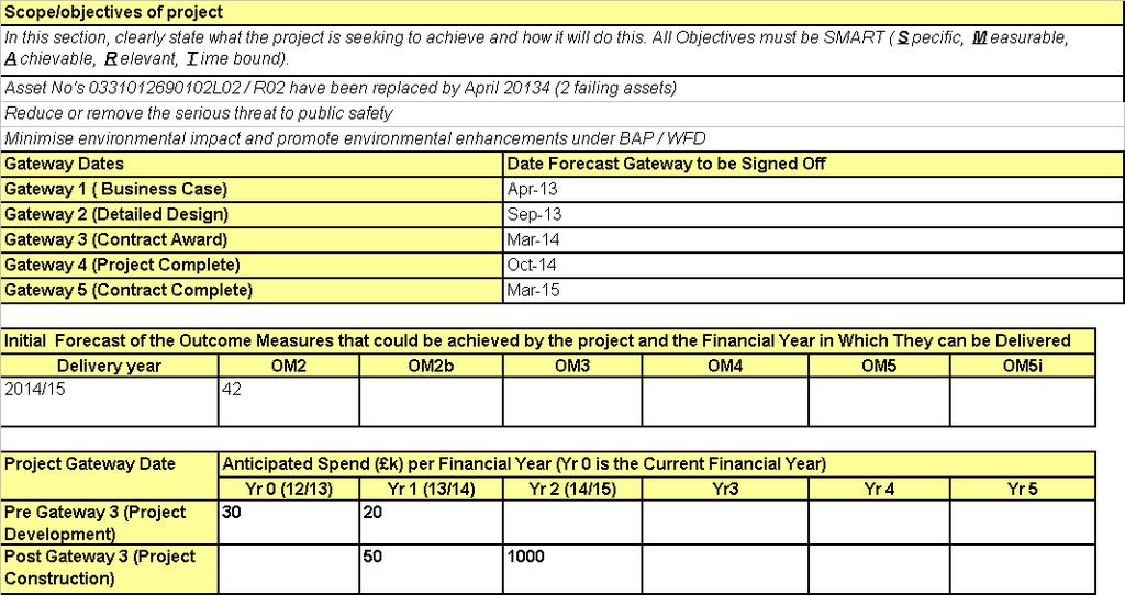
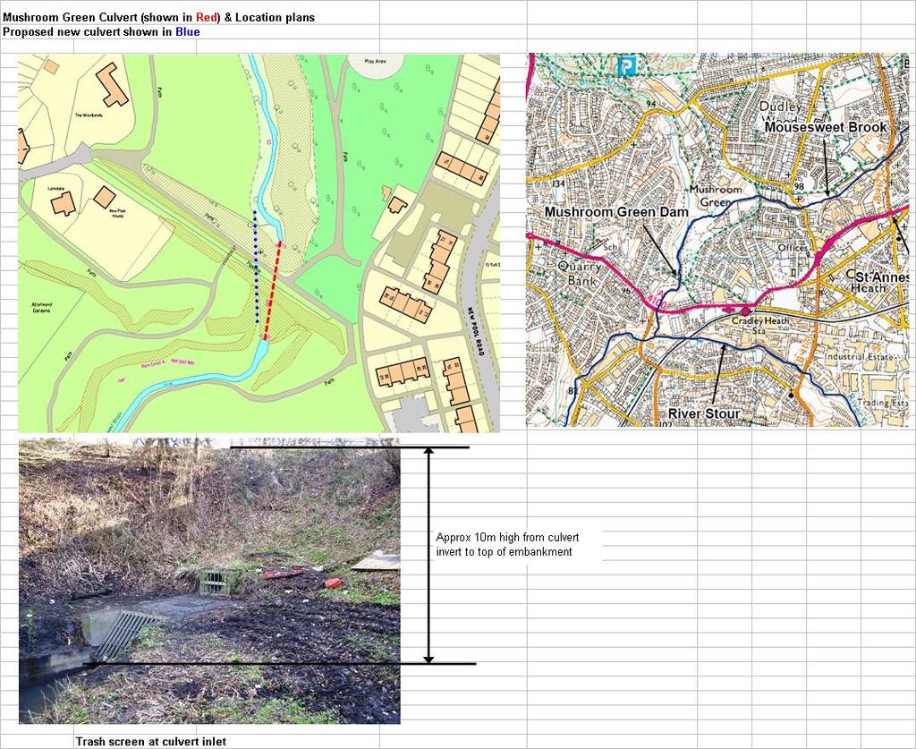
3 MTP 2012/13 MODERATION EVIDENCE EA Unique Project Reference: SNC001F/000A/001A Project Name: Mushroom Green Dam RFCC: Severn EA Region: Midlands Operating Authority: Dudley MBC EA Area: Central Reason for Moderation Evidence: Statutory Requirement Legal Agreement Study Other / EA Policy X Health & Safety Description Mushroom Green Dam is located at the downstream section of the Mousesweet Brook, near the confluence with the River Stour, Dudley. A 50m culvert, which runs through the 10m high embankment is failing (grade 4) due to its poor condition. In 2000 land behind the dam (a local nature reserve) flooded to approx 120,000 m3 volume and began seeping through the embankment. The EA & LA's attended the scene and over-pumped to draw down water and prevent a sudden failure. A long term solution in partnership with the EA, Sandwell MBC and Severn Trent Water is sought to reduce the risk of a breach if a large event re-occurs or the culvert collapses. Dudley MBC undertook a ground investigation in 2012 to ascertain the condition and composition of the embankment, which was found to be made of unsuitable material. The embankment is NOT deemed to be classified as a Reservoir, due to it historically acting as a former mineral railway. However, it remains the opinion of both LA's and the EA Central FCRM team that Mushroom Green Dam poses a serious threat to public safety and has been included on the regional high risk sites register. The EA commissioned a 'Breach scenario hazard mapping study' in It concluded that there is little benefit to retain flood water against the embankment, and if it were to breach then there is significant downstream risk within flood zone 2 are at risk. A minimum of 142 properties (including 42 residential) and critical infrastructure such as roads, services and a sewage treatment works. The shape file is extended to the confluence with the Smestow Brook at Stourton, however effects could extend further downstream towards Kidderminster. There are 4 strategic foul sewers which run through and along the top of the embankment, which are owned by Severn Trent Water. STW completed surveys to determine their asset details & condition in It is envisaged they may contribute further - including their 'time in kind' for the project to ensure these assets are fully protected.
4
5
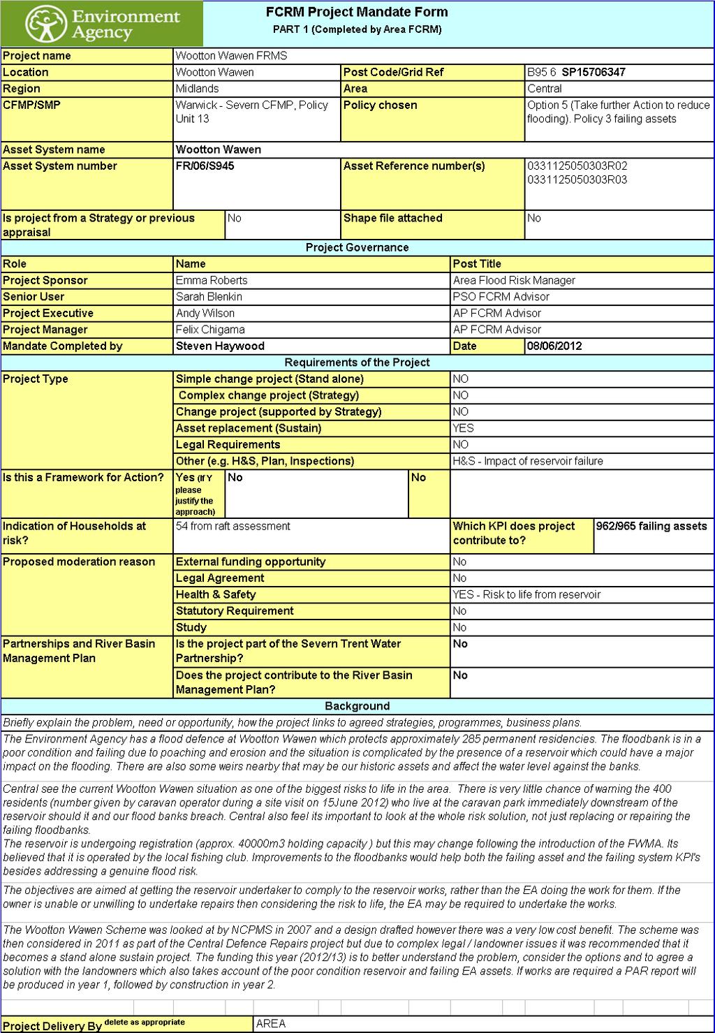
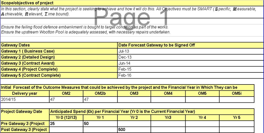
6 MTP 2013/14 MODERATION EVIDENCE EA Unique Project Reference: SNC001E/000A/001B Project Name: Wootton Wawen RFCC: Severn Risk Management Authority: EA EA Region: Midlands EA Area: Central Area Reason for Moderation Evidence: Statutory Requirement Legal Agreement Study Other / EA Policy X Health & Safety Description (robust, succinct, explain the problem, demonstrate the need for urgency, and outline the benefits in order to be able to justify the project; - not just a description of the work to be carried out). The Environment Agency is responsible for flood defences adjacent to a privately-owned reservoir (Wotton Pool) which is going through registration to fall under the ambit of the Reservoir Act Landowners negotiations have been progressed by the Reservoir Enforcement at Exeter. There is concern that the level of work required to bring the reservoir to an acceptable standard, may be outside of the landowners capabilities. The reservoir holds approx. 40,000 cubic metres of water and lies immediately upstream of a caravan site with 285 permanently fixed dwellings accommodating about 400 residents (figure given by caravan site operator during our site visit on 15 June 2012). NAFRA data has estimated 47 dwellings to be at v.significant or significant risk and these figures have been used as part of this bid. However it is the opinion of the Area office that these figures substantially underestimate the number of dwellings at risk. The right bank defences owned by the EA are located downstream of the abovementioned reservoir and are currently classified as failing assets or grade 4 assets. Due to the potential consequences of failure of the reservoir and subsequently of the EA failing flood defences, there is a strong argument to finding a joined-up solution to address the compliance of the reservoir, improvement of existing flood defences and works to the dilapidated weirs on the R Alne which could also be failing under WFD. Proposed Approach 1. Early FY : Undertake an options Appraisal to confirm EA approach towards managing the reservoir and failing asset. There are multiple factors to be considered that will affect the cost, time and the most appropriate approach. This year s allocation has been provided to analyse these factors and agree a best way forward. The findings of the Options Appraisal will confirm future funding requirements and delivery timescales. 2. Early FY Prepare a Business Case, if EA deem intervention is required. 3. Late FY Carry out Detailed Design of chosen option 4. Mid-Late FY Award a Contract for construction 5. FY Project complete
7
8
9 MTP 2013/14 MODERATION EVIDENCE EA Unique Project Reference: SNC001F/000A/020A Project Name: Snuff Mill Flood Alleviation RFCC: Severn Risk Management Authority: Wyre Forest District Council, acting on behalf of Worcestershire County Council (LLFA) Reason for Moderation Evidence: EA Region: Midlands EA Area: West Description (robust, succinct, explain the problem, demonstrate the need for urgency, and outline the benefits in order to be able to justify the project; - not just a description of the work to be carried out). Several pool structures along the Snuff Mill Brook system were damaged in the 2007 floods. These structures are considered to be high risk structures by virtue of their total capacity when considered as a cascade and the consequence of failure based on their proximity to housing in Bewdley. The All Reservoirs Panel Engineer that was commissioned by the council in 2011 has advised that should another significant storm occur, it is highly likely that more structures will be severely damaged or even fail. In addition, the engineer has identified two empty structures in the valley of the brook, thought to be remnants of additional historic mill ponds, which could at the moment fill uncontrolled, further increasing the risk to properties downstream. It is fully appreciated that the individual landowners are ultimately responsible for the operation, maintenance and repair of the structures on their land. However, since some of the empty structures actually provide the unique opportunity to create additional storage in this steep sided catchment, obviously serving a wider public benefit, the Council has decided to step in. The aim is to carry out an integrated investigation into the measures that are needed to create additional storage capacity using the empty structures identified. It is felt that the inevitable works to the empty structures in the Snuff Mill Valley could and should be combined with the creation of additional storage capacity for the brook, thereby not only reducing the risk posed by these structures, but also minimising the flood risk originating from a large storm event actually overwhelming the capacity of the brook. A first investigation, including some coarse modelling, has identified that it should be technically feasible to store enough water to minimise the risk from the brook to Bewdley in a design flow that is tentatively considered to be a 1 in 100 year flow. This additional storage is thought to reduce the flood risk that the brook currently poses to 46 properties in the town centre of Bewdley, including 37 houses, a craft centre and 2 community halls.
Flood Risk Sequential Test
 Flood Risk Sequential Test Assessment of Proposed Development Sites Stroud District Council Evidence Base (December 2013) Development and Flood Risk Sequential Test 1.0 Introduction 1.1 This document considers
Mapping flood risk its role in improving flood resilience in England
 Mapping flood risk its role in improving flood resilience in England Catherine Wright Director of Digital and Skills Flood and Coastal Risk Management Environment Agency 6 October 2017 The Environment
Guildford Borough Level 1 Strategic Flood Risk Assessment Summary Report. January 2016
 Guildford Borough Level 1 Strategic Flood Risk Assessment Summary Report January 2016 What is this document? This document provides a summary of Guildford Borough Strategic Flood Risk Assessment (SFRA,
Combined Sources Product
 Combined Sources Product EA Data Advisory Group Selena Peters: FCRM Mapping, Modelling and Data 18 June 2015 selena.peters@environment-agency.gov.uk Assessing flood risk New Product What? Combined Sources
Shrewsbury flood defen
 EA-MIDLANDS Shrewsbury flood defen -y r * * 0 ^ The next steps E n v ir o n m e n t A g e n c y Shrewsbury is cradled within a picturesque horseshoe loop of the River Severn. Over centuries, the river
Shropshire Local Flood Risk Management Strategy. Summary for Consultation. July 2014
 Shropshire Local Flood Risk Management Strategy Summary for Consultation July 2014 SHROPSHIRE LOCAL FLOOD RISK MANAGEMENT STRATEGY 1 Introduction This Strategy is about managing flooding in Shropshire.
Strategic Flood Risk Assessment for SDCC Development Plan
 Strategic Flood Risk Assessment for SDCC Development Plan Detailed Report on Flood Risk in the Baldonnell Area 8 th May 2015 rpsgroup.com/ireland Strategic Flood Risk Assessment for SDCC Development Plan
Joint Lincolnshire Flood Risk and Drainage Management Strategy: Draft v.6.0:consultation Draft, : Annexes A-F
 Lincolnshire Flood Risk and Drainage Management Partnership Framework Lincolnshire Joint Flood Risk and Drainage Management Strategy Draft v.6.0 Consultation Draft 23 rd May 2012 Annexes A-F Joint Lincolnshire
Sequential Flood Risk Test for Mid Sussex Neighbourhood Plans
 Sequential Flood Risk Test for Mid Sussex Neighbourhood Plans Introduction This Sequential Test has been prepared to assess the flood risk of sites within the parish that have been identified as suitable,
Explanatory Memorandum to The Reservoirs Act 1975 (Exemptions, Appeals and Inspections) (Wales) Regulations 2015
 (Wales) Regulations 2015") Explanatory Memorandum to The Reservoirs Act 1975 (Exemptions, Appeals and Inspections) (Wales) Regulations 2015 This Explanatory Memorandum has been prepared by the Department for Economy, Skills and
Explanatory Memorandum to The Reservoirs Act 1975 (Exemptions, Appeals and Inspections) (Wales) Regulations 2015 This Explanatory Memorandum has been prepared by the Department for Economy, Skills and
Peter Brett Associates. Assessing Flood Risk and River Modelling Doulton Brook Development, West Midlands
 Peter Brett Associates Assessing Flood Risk and River Modelling Doulton Brook Development, West Midlands PLANNING POLICY INTRODUCTION For any proposed residential development close to a river or watercourse
Chapter Flood Consequences
 Chapter 2.16. Flood Consequences 438 16. Flood Consequences 16.1. Introduction and Scope of Topic 16.1.1. This chapter identifies and describes the existing flood risk features along the route of the Scheme
St. Asaph Flood Risk Management Scheme Case Study The Solution
 St. Asaph Flood Risk Management Scheme Case Study The Solution Date Assessing the options for the Flood Risk Management Scheme Each of the flood risk management options were assessed against the following
Flood and Coastal Risk Management - A Risk Based. David Rooke Head of Flood & Coastal Risk Management 20 March 2009
 Flood and Coastal Risk Management - A Risk Based Approach David Rooke Head of Flood & Coastal Risk Management 20 March 2009 Risk Significant risks to the delivery of Defra s outcomes in this area Consequence
Flood Risk Management
 Flood Risk Management COUNTY SUMMARY COUNTY: MONAGHAN (Information correct as of 31/12/2017) CONTENTS: 1. OPW Capital Investment to 31 December 2017 a. Major Flood Relief Schemes 1995 2017 b. Minor Flood
MATARAWA FLOOD CONTROL SCHEME EXTENSION (PRD 5 20)
") Report No. 17-05 Decision Required MATARAWA FLOOD CONTROL SCHEME EXTENSION (PRD 5 20) 1. PURPOSE 1.1. The purpose of this item is to seek the approval of the Committee (and ultimately Council) to include
Report No. 17-05 Decision Required MATARAWA FLOOD CONTROL SCHEME EXTENSION (PRD 5 20) 1. PURPOSE 1.1. The purpose of this item is to seek the approval of the Committee (and ultimately Council) to include
Strategic Flood Risk Assessment
 PLANNING DEPARTMENT, KILKENNY COUNTY COUNCIL Strategic Flood Risk Assessment Proposed Amendment No. 2 of Callan Local Area Plan 2009-2020 Forward Planning January 2016 This Strategic Flood Risk Assessment
Flood Risk Management Planning in Scotland: Arrangements for February 2012
 Flood Risk Management Planning in Scotland: Arrangements for 2012 2016 February 2012 Flood Risk Management (Scotland) Act 2009 1 Contents Forewords 1. Introduction to this document... 5 2. Sustainable
Unique ID: (from PFRA database) Location: Nenagh, Co. Tipperary. Stage 1: Desktop Review
 Location: Nenagh, Co. Tipperary. Stage 1: Desktop Review") Location: Nenagh, Co. Tipperary Unique ID: 250432 (from PFRA database) Initial OPW Designation APSR AFRR IRR Co-ordinates Easting: 186604 Northing: 178781 River / Catchment / Sub-catchment Nenagh River
Location: Nenagh, Co. Tipperary Unique ID: 250432 (from PFRA database) Initial OPW Designation APSR AFRR IRR Co-ordinates Easting: 186604 Northing: 178781 River / Catchment / Sub-catchment Nenagh River
CHAPTER 10 FLOOD RISK
 CHAPTER 10 FLOOD RISK 10.1 Introduction and Key Issues 10.1.1 This chapter describes the likely effects that the construction and operation of the Upgrade will have on flood risk. The potential effects
Problem Overview. Key Flood extent for present day 1% (or 1 in 100) chance flood event. Dinas Powys. Barry Industrial Area.
 chance flood event. Dinas Powys. Barry Industrial Area.") Problem Overview Flood Risk The has a history of flooding, in both and the Barry Industrial Area. Due to this, we have completed mathematical modelling to understand the catchment and predict the flood
Problem Overview Flood Risk The has a history of flooding, in both and the Barry Industrial Area. Due to this, we have completed mathematical modelling to understand the catchment and predict the flood
Ellon (Potentially Vulnerable Area 06/12) Local Plan District North East Local authority Aberdeenshire Council Main catchment River Ythan, Buchan coas
 Local Plan District North East Local authority Aberdeenshire Council Main catchment River Ythan, Buchan coas") Ellon (Potentially Vulnerable Area 06/12) Local Plan District North East Local authority Aberdeenshire Council Main catchment River Ythan, Buchan coastal Summary of flooding impacts 110 residential 40
Ellon (Potentially Vulnerable Area 06/12) Local Plan District North East Local authority Aberdeenshire Council Main catchment River Ythan, Buchan coastal Summary of flooding impacts 110 residential 40
Flood Risk Assessment for Planning
 Flood Risk Assessment for Planning Report on: Sample Property, Sample Town, Sample Postcode Report prepared for: Report Reference: Report Date: Sample AEL-XXXX-FRA-XXXX 28 th October 2016 Client Reference:
STRATEGIC FLOOD RISK ASSESSMENT
 STRATEGIC FLOOD RISK ASSESSMENT FOR PROPOSED VARIATION NO. 1 (CORE STRATEGY) TO THE LONGFORD TOWN DEVELOPMENT PLAN 2009-2015 for: Longford Local Authorities Great Water Street, Longford, Co. Longford by:
Flood Risk and Land Use Vulnerability Guidance
 Flood Risk and Land Use Vulnerability Guidance UPS-BP-GU2a v.2 UNCONTROLLED DOCUMENT WHEN PRINTED Pag SCOTTISH ENVIRONMENT PROTECTION AGENCY Identifier: LUPS-GU24 Land Use Planning System SEPA Guidance
Elgin (Potentially Vulnerable Area 05/05) Local Planning District Local authority Main catchment Findhorn, Nairn and Speyside The Moray Council River
 Local Planning District Local authority Main catchment Findhorn, Nairn and Speyside The Moray Council River") Elgin (Potentially Vulnerable Area 05/05) Findhorn, Nairn and Speyside Local authority The Moray Council Main catchment River Lossie Summary of flooding impacts Summary of flooding impacts At risk of flooding
Elgin (Potentially Vulnerable Area 05/05) Findhorn, Nairn and Speyside Local authority The Moray Council Main catchment River Lossie Summary of flooding impacts Summary of flooding impacts At risk of flooding
FLOOD SOLUTIONS Residence
 FLOOD SOLUTIONS Residence Report prepared on 22 Knighton Road, Liverpool, L4 9RD Report reference AEL028FLR022381 National grid reference 337815, 394462 Report prepared for Specimen Client Client reference
Alyth (Potentially Vulnerable Area 08/04) Local Plan District Local authority Main catchment Tay Perth and Kinross Council Alyth Burn (River Tay) Back
 Local Plan District Local authority Main catchment Tay Perth and Kinross Council Alyth Burn (River Tay) Back") Alyth (Potentially Vulnerable Area 08/04) Local Plan District Tay Local authority Perth and Kinross Council Main catchment Alyth Burn (River Tay) Summary of flooding impacts 50 residential properties 20
Alyth (Potentially Vulnerable Area 08/04) Local Plan District Tay Local authority Perth and Kinross Council Main catchment Alyth Burn (River Tay) Summary of flooding impacts 50 residential properties 20
Hillfoots Villages (Potentially Vulnerable Area 09/04) Local Plan District Forth Local authority Clackmannanshire Council, Stirling Council Main catch
 Local Plan District Forth Local authority Clackmannanshire Council, Stirling Council Main catch") Hillfoots Villages (Potentially Vulnerable Area 09/04) Local Plan District Forth Local authority Clackmannanshire Council, Stirling Council Main catchment River Devon Summary of flooding impacts Summary
Hillfoots Villages (Potentially Vulnerable Area 09/04) Local Plan District Forth Local authority Clackmannanshire Council, Stirling Council Main catchment River Devon Summary of flooding impacts Summary
Protocol for the maintenance of flood and coastal risk management assets (England only) Version 4, 27/01/2014 UNCLASSIFIED
 Version 4, 27/01/2014 UNCLASSIFIED") Protocol for the maintenance of flood and coastal risk management assets (England only) Version 4, 27/01/2014 UNCLASSIFIED We are the Environment Agency. We protect and improve the environment and make
Protocol for the maintenance of flood and coastal risk management assets (England only) Version 4, 27/01/2014 UNCLASSIFIED We are the Environment Agency. We protect and improve the environment and make
Strategic Flood Risk Assessment
 Strategic Flood Risk Assessment Draft Claremorris Local Area Plan 2012 2018 Prepared by Forward Planning Section Mayo County Council 1 Table of Contents Section 1: Overview of the Guidelines... 4 1.1 Introduction...
National Assessment of Defence Needs and Costs for flood and coastal erosion management (NADNAC) Summary Report
 Summary Report") National Assessment of Defence Needs and Costs for flood and coastal erosion management (NADNAC) Summary Report Flood Management Division June 2004 Contents Contents, Abbreviations and Glossary...1 1 Introduction...2
National Assessment of Defence Needs and Costs for flood and coastal erosion management (NADNAC) Summary Report Flood Management Division June 2004 Contents Contents, Abbreviations and Glossary...1 1 Introduction...2
Devon Local Flood Risk Management Strategy Update
 Devon Local Flood Risk Management Strategy Update April 2017 Newsletter Devon s Local Flood Risk Management Strategy was published in June 2014 and is supported by an annual Action Plan which prioritises
Lowestoft. Summary 2016 FLOOD RISK MANAGEMENT. Mike Page
 Mike Page Lowestoft FLOOD RISK MANAGEMENT Strategy Summary 2016 Introduction This Strategy Summary Document is a brief overview of the Strategy for managing the risk of flooding to Lowestoft from the sea,
Conon Bridge and Muir of Ord (Potentially Vulnerable Area 01/16) Local authority Main catchment The Highland Council River Conon Background This Poten
 Local authority Main catchment The Highland Council River Conon Background This Poten") Conon Bridge and Muir of Ord (Potentially Vulnerable Area 01/16) Local authority The Highland Council Main catchment River Conon Summary of flooding impacts Summary of flooding impacts At risk of flooding
Conon Bridge and Muir of Ord (Potentially Vulnerable Area 01/16) Local authority The Highland Council Main catchment River Conon Summary of flooding impacts Summary of flooding impacts At risk of flooding
River Severn Catchment Flood Management Plan. Summary Report December managing flood risk
 River Severn Catchment Flood Management Plan Summary Report December 2009 managing flood risk We are the Environment Agency. It s our job to look after your environment and make it a better place for you,
BLESSINGTON LOCAL AREA PLAN FLOOD RISK ASSESSMENT
 BLESSINGTON LOCAL AREA PLAN 2013-2019 FLOOD RISK ASSESSMENT Table of Contents Page Number 1.0 INTRODUCTION 1 1.1 Definition of Flooding 2 1.2 Policy Framework 2 1.3 Flood Risk Identification 3 1.4 Mapping
Please find attached your: FCI Flood Commercial <0.25Ha
 Please find attached your: FCI Commercial
Flood Investigation Report
 Flood Investigation Report Bar Hill 1.1 Background As the Lead Local Flood Authority (LLFA) for Cambridgeshire, it is Cambridgeshire County Council s duty to investigate flood incidents as detailed within
Minutes of a Meeting of the Black Country Local Enterprise Partnership
 Minutes of a Meeting of the Black Country Local Enterprise Partnership 20 th March 2017 at 3.00p.m. at NMC, 47 Birmingham Road, West Bromwich Present: Stewart Towe Chair; Simon Eastwood Carrillion plc;
Flood Risk Management Strategy. Shetland
 Flood Risk Management Strategy Shetland Publication date: 14 December 2015 Terms and conditions Ownership: All intellectual property rights for Flood Risk Management Strategies are owned by SEPA or its
Kirkwall (Potentially Vulnerable Area 03/05) Local Plan District Local authority Main catchment Orkney Orkney Islands Council Orkney coastal Backgroun
 Local Plan District Local authority Main catchment Orkney Orkney Islands Council Orkney coastal Backgroun") Kirkwall (Potentially Vulnerable Area 03/05) Local Plan District Orkney Local authority Orkney Islands Council Main catchment Orkney coastal Summary of flooding impacts 490 residential properties 460 non-residential
Kirkwall (Potentially Vulnerable Area 03/05) Local Plan District Orkney Local authority Orkney Islands Council Main catchment Orkney coastal Summary of flooding impacts 490 residential properties 460 non-residential
FREQUENTLY ASKED QUESTION ABOUT FLOODPLAINS Michigan Department of Environmental Quality
 FREQUENTLY ASKED QUESTION ABOUT FLOODPLAINS Michigan Department of Environmental Quality WHAT IS A FLOOD? The National Flood Insurance Program defines a flood as a general and temporary condition of partial
The AIR Inland Flood Model for Great Britian
 The AIR Inland Flood Model for Great Britian The year 212 was the UK s second wettest since recordkeeping began only 6.6 mm shy of the record set in 2. In 27, the UK experienced its wettest summer, which
Luncarty, Stanley, Bankfoot, Dunkeld and Birnam (Potentially Vulnerable Area 08/08) Local Plan District Local authority Main catchment Tay Perth and K
 Local Plan District Local authority Main catchment Tay Perth and K") Luncarty, Stanley, Bankfoot, Dunkeld and Birnam (Potentially Vulnerable Area 08/08) Local Plan District Tay Local authority Perth and Kinross Council Main catchment River Tay Summary of flooding impacts
Luncarty, Stanley, Bankfoot, Dunkeld and Birnam (Potentially Vulnerable Area 08/08) Local Plan District Tay Local authority Perth and Kinross Council Main catchment River Tay Summary of flooding impacts
Strategic Flood Risk Assessment
 Strategic Flood Risk Assessment Ireland West Airport Knock Local Area Plan 2012 2018 Prepared by Forward Planning Section Mayo County Council 0 1 Table of Contents Section 1: Overview of the Guidelines...
HAZARD DESCRIPTION... 1 LOCATION... 2 EXTENT... 4 HISTORICAL OCCURRENCES... 6 PROBABILITY OF FUTURE EVENTS... 6 VULNERABILITY AND IMPACT...
 DAM FAILURE HAZARD DESCRIPTION... 1 LOCATION... 2 EXTENT... 4 HISTORICAL OCCURRENCES... 6 PROBABILITY OF FUTURE EVENTS... 6 VULNERABILITY AND IMPACT... 6 Hazard Description Dams are water storage, control
Solway Local Plan District 1 Flood risk management in Scotland 1.1 What is a Flood Risk Management Strategy? Flood Risk Management Strategies have bee
 Flood Risk Management Strategy Solway Local Plan District Section 1: Flood Risk Management in Scotland 1.1 What is a Flood Risk Management Strategy?... 1 1.2 How to read this Strategy... 1 1.3 Managing
Jayne Smailes, CEO Lydney Town Council (JS) Kate Hammond, Admin Assistant, Lydney Town Council (Minute Taker)
 Kate Hammond, Admin Assistant, Lydney Town Council (Minute Taker)") Minutes of the Multi Agency Flood Defence Meeting held on Thursday 2 nd October 2014 in Lydney Town Council Chambers at 10.30 am PRESENT: IN ATTENDANCE: APOLOGIES: Cllr Brian Thomas, Lydney NDP (BT) Cllr
Minutes of the Multi Agency Flood Defence Meeting held on Thursday 2 nd October 2014 in Lydney Town Council Chambers at 10.30 am PRESENT: IN ATTENDANCE: APOLOGIES: Cllr Brian Thomas, Lydney NDP (BT) Cllr
SAMPLE. Flood Residential <0.25Ha. Report Details. Subject Site. Professional Opinion. Flood. Requested by: Address: Grid Reference: E: N: 12345
 Report Details Subject Site Address: Sample, Sample Requested by: Test Grid Reference: E: 12345 N: 12345 Date: 13/04/2018 Report Reference: Report ID: SampleResi 1000072147 Professional Opinion 1.FLOOD
Flood Risk Assessment Appendix 1 to Strategic Environmental Assessment Screening of Amendment No. 1 to Ferrybank/Belview Local Area Plan
 Flood Risk Assessment Appendix 1 to Strategic Environmental Assessment Screening of Amendment No. 1 to Ferrybank/Belview Local Area Plan Forward Planning Kilkenny County Council 18/8/2011 1 Introduction
Bates, P. D. (2016). Flooding: what is normal? Science in Parliament, 73(1),
. Flooding: what is normal? Science in Parliament, 73(1),") Bates, P. D. (2016). Flooding: what is normal? Science in Parliament, 73(1), 25-26. Peer reviewed version License (if available): Unspecified Link to publication record in Explore Bristol Research PDF-document
Bates, P. D. (2016). Flooding: what is normal? Science in Parliament, 73(1), 25-26. Peer reviewed version License (if available): Unspecified Link to publication record in Explore Bristol Research PDF-document
Managing the Risk and Impact of Regional Flooding
 Managing the Risk and Impact of Regional Flooding Ben Lukey FCRM Manager Strategy & Investment Environment Agency Wednesday 8 June 2016 Environment Agency - Who are we? Our role in Flood Risk Management
Planning and Flood Risk
 Planning and Flood Risk Patricia Calleary BE MEngSc MSc CEng MIEI After the Beast from the East Patricia Calleary Flood Risk and Planning Flooding in Ireland» Floods are a natural and inevitable part of
Turriff (Potentially Vulnerable Area 06/07) Local Plan District Local authority Main catchment North East Aberdeenshire Council River Deveron Backgrou
 Local Plan District Local authority Main catchment North East Aberdeenshire Council River Deveron Backgrou") Turriff (Potentially Vulnerable Area 06/07) Local Plan District North East Local authority Aberdeenshire Council Main catchment River Deveron Summary of flooding impacts At risk of flooding
Turriff (Potentially Vulnerable Area 06/07) Local Plan District North East Local authority Aberdeenshire Council Main catchment River Deveron Summary of flooding impacts At risk of flooding
Inverurie and Kintore (Potentially Vulnerable Area 06/13) Local Plan District Local authority Main catchment North East Aberdeenshire Council River Do
 Local Plan District Local authority Main catchment North East Aberdeenshire Council River Do") Inverurie and Kintore (Potentially Vulnerable Area 06/13) Local Plan District North East Local authority Aberdeenshire Council Main catchment River Don Summary of flooding impacts 230 residential properties
Inverurie and Kintore (Potentially Vulnerable Area 06/13) Local Plan District North East Local authority Aberdeenshire Council Main catchment River Don Summary of flooding impacts 230 residential properties
FLOODING INFORMATION SHEET YOUR QUESTIONS ANSWERED
 The information in this document has been written in partnership by the Association of British Insurers and the Environment Agency 1. Flood risk and insurance Q1. How can I find out the flood risk affecting
Truckloads (at 25 tons/truck) of building debris 90
 of building debris 90") Marlborough Marlborough is a rural community in Hartford County covering a land area of 23.3 square miles and with an estimated population of 6,410. Elevation ranges from about 160 to 800 feet. The Town
Marlborough Marlborough is a rural community in Hartford County covering a land area of 23.3 square miles and with an estimated population of 6,410. Elevation ranges from about 160 to 800 feet. The Town
Environment Agency pre-application advice incorporating Local Flood Risk Standing Advice from East Lindsey District Council
 Environment Agency pre-application advice incorporating Local Flood Risk Standing Advice from East Lindsey District Council Version 1 UNCLASSIFIED We are the Environment Agency. We protect and improve
Please find attached your: FCI Flood Residential <0.25Ha
 Please find attached your: FCI Residential
Flood Risk Management in England
 REPORT BY THE COMPTROLLER AND AUDITOR GENERAL HC 1521 SESSION 2010 2012 28 OCTOBER 2011 Department for Environment, Food and Rural Affairs and Environment Agency Flood Risk Management in England Flood
London Borough of Sutton Local Flood Risk Management Strategy Action Draft for Consultation
 London Borough of Sutton Local Flood Risk Strategy Action Draft for Consultation This Action Plan supports the London Borough of Sutton Local Flood Risk Strategy (v1.0) July 2014. The reader should refer
East Sussex Local Flood Risk Management Strategy
 eastsussex.gov.uk East Sussex Local Flood Risk Management Strategy 2013 2014 Delivery Plan Delivery Plan The following table sets out the actions that will be progressed over the coming year by the risk
Understanding the risks, empowering communities, building resilience: the national flood and coastal erosion risk management strategy for England
 14669 NFS Cor Slip / Sig: 1 / Plate A Understanding the risks, empowering communities, building resilience: the national flood and coastal erosion risk management strategy for England Session: 2010-2012
Castle Douglas (Potentially Vulnerable Area 14/11) Local Plan District Local authority Main catchment Dumfries and Galloway Solway River Dee (Solway)
 Local Plan District Local authority Main catchment Dumfries and Galloway Solway River Dee (Solway)") Castle Douglas (Potentially Vulnerable Area 14/11) Local Plan District Solway Local authority Dumfries and Galloway Council Main catchment River Dee (Solway) Summary of flooding impacts 180 residential
Castle Douglas (Potentially Vulnerable Area 14/11) Local Plan District Solway Local authority Dumfries and Galloway Council Main catchment River Dee (Solway) Summary of flooding impacts 180 residential
Newton Stewart (Potentially Vulnerable Area 14/12) Local Plan District Local authority Main catchment Dumfries and Galloway Solway River Cree Council
 Local Plan District Local authority Main catchment Dumfries and Galloway Solway River Cree Council") Newton Stewart (Potentially Vulnerable Area 14/12) Local Plan District Solway Local authority Dumfries and Galloway Council Main catchment River Cree Summary of flooding impacts 210 residential properties
Newton Stewart (Potentially Vulnerable Area 14/12) Local Plan District Solway Local authority Dumfries and Galloway Council Main catchment River Cree Summary of flooding impacts 210 residential properties
Nairn Central (Potentially Vulnerable Area 01/18) Local authority Main catchment The Highland Council Moray coastal Background This Potentially Vulner
 Local authority Main catchment The Highland Council Moray coastal Background This Potentially Vulner") Nairn Central (Potentially Vulnerable Area 01/18) Local authority The Highland Council Main catchment Moray coastal Summary of flooding impacts At risk of flooding 350 residential 30 non-residential 340,000
Nairn Central (Potentially Vulnerable Area 01/18) Local authority The Highland Council Main catchment Moray coastal Summary of flooding impacts At risk of flooding 350 residential 30 non-residential 340,000
Fort William (Potentially Vulnerable Area 01/25) Local authority Main catchment The Highland Council Appin coastal Background This Potentially Vulnera
 Local authority Main catchment The Highland Council Appin coastal Background This Potentially Vulnera") Fort William (Potentially Vulnerable Area 01/25) Local authority The Highland Council Main catchment Appin coastal Summary of flooding impacts 100 residential properties 80 non-residential properties 520,000
Fort William (Potentially Vulnerable Area 01/25) Local authority The Highland Council Main catchment Appin coastal Summary of flooding impacts 100 residential properties 80 non-residential properties 520,000
East Hartford. Challenges
 East Hartford The Town of East Hartford is a suburban community of approximately 52,212 located east of the City of Hartford and west of the Town of Manchester. The Town covers slightly more than 18 square
Flood Investigation Report
 Flood Investigation Report Oakington 1.1 Background As the Lead Local Flood Authority (LLFA) for Cambridgeshire, it is Cambridgeshire County Council s (CCC) duty to investigate flood incidents as detailed
Frequently Asked Questions Oxbow / Hickson / Bakke Ring Levee Option
 Frequently Asked Questions Oxbow / Hickson / Bakke Ring Levee Option October 16, 2012 Q1. Why has the position on a ring-levee changed? The feasibility study recommended buy-outs for areas with staging
LLDC Flood Risk Review Summary Report. Issue 2 13 January 2017
 Issue 2 13 January 2017 This report takes into account the particular instructions and requirements of our client. It is not intended for and should not be relied upon by any third party and no responsibility
RESERVOIR LEGISLATION IN WALES
 RESERVOIR LEGISLATION IN WALES BASIC LEGAL FRAMEWORK The United Kingdom comprises four regional administrations, England, Wales, Scotland and Northern Ireland. Reservoirs in England and Wales are regulated
Review of preliminary flood risk assessments (Flood Risk Regulations 2009): guidance for lead local flood authorities in England
: guidance for lead local flood authorities in England") Review of preliminary flood risk assessments (Flood Risk Regulations 2009): guidance for lead local flood authorities in England 25 January 2017 We are the Environment Agency. We protect and improve the
Review of preliminary flood risk assessments (Flood Risk Regulations 2009): guidance for lead local flood authorities in England 25 January 2017 We are the Environment Agency. We protect and improve the
International Real Estate Society Conference 99. Long Term Impact of Flood Affectation on Residential Property Prices
 International Real Estate Society Conference 99 Co-sponcors: Pacific Rim Real Estate Society (PRRES) Asian Real Estate Society (AsRES) Khuala Lumpur, 26-30 January 1999 Long Term Impact of Flood Affectation
Eddleston, Peebles, Innerleithen, Selkirk, Stow and Galashiels (Potentially Vulnerable Area 13/04) Local Plan District Local authority Main catchment
 Local Plan District Local authority Main catchment") Eddleston, Peebles, Innerleithen, Selkirk, Stow and Galashiels (Potentially Vulnerable Area 13/04) Local Plan District Tweed Local authority Scottish Borders Council Main catchment River Tweed Summary
Eddleston, Peebles, Innerleithen, Selkirk, Stow and Galashiels (Potentially Vulnerable Area 13/04) Local Plan District Tweed Local authority Scottish Borders Council Main catchment River Tweed Summary
THAMES-COROMANDEL DISTRICT COUNCIL COASTAL HAZARDS POLICY
 THAMES-COROMANDEL DISTRICT COUNCIL COASTAL HAZARDS POLICY 1. OBJECTIVES a) To sustainably manage the effects of coastal hazards on the District s coastal foreshore land by ensuring risk to life and property
Greater Nottingham Strategic Flood Risk Assessment. Summary of Key Findings for Nottingham City Council
 Greater Nottingham Strategic Flood Risk Assessment Summary of Key Findings for Nottingham City Council July 2008 This page is intentionally left blank. GREATER NOTTINGHAM STRATEGIC FLOOD RISK ASSESSMENT
Celbridge. Local Area Plan STRATEGIC FLOOD RISK ASSESSMENT
 Celbridge Local Area Plan 2017-2023 Dréachtphlean Ceantair Áitiúil Cill Droichid STRATEGIC FLOOD RISK ASSESSMENT Planning Department Kildare County Council September 2017 Strategic Flood Risk Assessment
Section 2. Introduction and Purpose of the LMS
 Section 2. Introduction and Purpose of the LMS 2.1 Introduction The Disaster Mitigation Act of 2000 (DMA 2000), signed into law by the President of the United States on October 30, 2000 (P.L. 106-390),
Regulated Drainage & Water Search
 Regulated Drainage & Water Search Property Address: 31 Middle Pasture, Peterborough, PE4 5AU Name and Address of Data Source: Customer Services, PO Box 10642, Harlow, Essex, CM20 9HA Client Reference Search
Abstraction Charges Scheme 2017/18
 Abstraction Charges Scheme 2017/18 On 1 April 2013 Natural Resources Body for Wales (NRW) brought together the work of the Countryside Council for Wales, Environment Agency Wales and Forestry Commission
Aberfeldy and Pitlochry (Potentially Vulnerable Area 08/03) Local Plan District Local authority Main catchment Tay Perth and Kinross Council River Tay
 Local Plan District Local authority Main catchment Tay Perth and Kinross Council River Tay") Aberfeldy and Pitlochry (Potentially Vulnerable Area 08/03) Local Plan District Tay Local authority Perth and Kinross Council Main catchment River Tay Summary of flooding impacts 240 residential properties
Aberfeldy and Pitlochry (Potentially Vulnerable Area 08/03) Local Plan District Tay Local authority Perth and Kinross Council Main catchment River Tay Summary of flooding impacts 240 residential properties
Flood Risk Management New legislation New Duties!
 Flood Risk Management New legislation New Duties! Andy Cameron Lancashire County Council Senior Engineer Strategic Flood Risk Iwan Lawton Environment Agency Technical Specialist Development & Flood Risk
Environmental Change Institute. Long term investment strategy An independent review of the 2014 assessment Jim Hall
 Environmental Change Institute Long term investment strategy An independent review of the 2014 assessment Jim Hall Environment Agency Long Term Investment Scenarios What LTIS has achieved A scientific
Laois County Council Comhairle Chontae Laoise STRATEGIC FLOOD RISK ASSESSMENT PORTLAOISE DRAFT LOCAL AREA PLAN
 Laois County Council Comhairle Chontae Laoise STRATEGIC FLOOD RISK ASSESSMENT PORTLAOISE DRAFT LOCAL AREA PLAN 2018 2024 CONTENTS PORTLAOISE... 0 DRAFT LOCAL AREA PLAN... 0 2018 2024... 0 LIST OF FIGURES...
JANUARY 13, ILL. ADM. CODE CH. I, SEC TITLE 17: CONSERVATION CHAPTER I: DEPARTMENT OF NATURAL RESOURCES SUBCHAPTER h: WATER RESOURCES
 TITLE 17: CONSERVATION CHAPTER I: DEPARTMENT OF NATURAL RESOURCES SUBCHAPTER h: WATER RESOURCES PART 3702 CONSTRUCTION AND MAINTENANCE OF DAMS Section Page No. 3702.10 Purpose 2 3702.20 Definitions 3 3702.30
CHAPTER 15: FLOODPLAIN OVERLAY DISTRICT "FP"
 CHAPTER 15: FLOODPLAIN OVERLAY DISTRICT "FP" SECTION 15.1 STATUTORY AUTHORIZATION The legislature of the State of Minnesota in Minnesota Statutes, Chapter 103F and Chapter 394 has delegated the responsibility
Herkimer County, New York Flood Hazard Mapping Status Report for Property Owners
 Herkimer County, New York Flood Hazard Mapping Status Report for Property Owners Herkimer County, New York Flood Hazard Mapping Status Report for Property Owners FLOOD INSURANCE Who Should Purchase Flood
P art B 4 NATURAL HAZARDS. Natural Hazards ISSUE 1. River Flooding
 4 NATURAL HAZARDS ISSUE 1 River Flooding A large part of the plains within the Timaru District is subject to some degree of flooding risk. At least part of all of the main settlements in the District and
Document Control Sheet
 Strategic Flood Risk Assessment of the Maynooth Local Area Plan 2013-2019 Proposed Amendment No. 1 Document Control Sheet Client: Project Title: Document Title: Document No: Kildare County Council Strategic
Sample Site, Sample Street, Sample Town
 Telephone: 2 7261 191 Email: SitecheckFlood@rpsgroup.com Sample Site, Sample Street, Sample Town Prepared for: L And1 Landmark1 Account Landmark(Test Account) 6-7 Abbey Court, Sowton Ind Estate Exeter
Appendix 12.3 Flood Risk Assessment
 Appendix 12.3 Flood Risk Assessment Contents A12.3-1.1 Scope of Work 1 A12.3-1.2 Summary of Data Used 1 A12.3-1.3 Proposed Project 2 A12.3-2.1 The Planning System and Flood Risk Management Guidelines 2
ADA Local Authority Seminar /03/2012. Working in Partnership. ADA Local Authority Seminar 29 th March 2012
 Working in Partnership ADA Local Authority Seminar 29 th March 2012 Peter Bateson, Chief Executive Witham Fourth District IDB The Partnership Lincolnshire Flood Risk and Drainage Management Partnership
Implementing risk-based asset management strategies
 Implementing risk-based asset management strategies 2018. 04. 17 Disaster Resilience by Design The challenge for local governments The Challenge for Local Governments Landslides Debris Flows Wildfire Wind
Working with natural processes to help manage flood risk natural flood management Dr. Heather Forbes. Scottish Environment Protection Agency
 Working with natural processes to help manage flood risk natural flood management Dr. Heather Forbes Senior Policy Officer Programme Scottish Environment Protection Agency Scotland s flood risk 56% 21%
Flood Risk Assessment Cobh Town Plan Cobh Town Development Plan Volume 2: Strategic Flood Risk Assessment
 Flood Risk Assessment Cobh Town Plan 2013 Cobh Town Development Plan 2013 Volume 2: Strategic Flood Risk Assessment Cobh Town Plan 2013 Flood Risk Assessment Document Verification Page 1 of 1 Job Title:
FILE: and EFFECTIVE DATE: September 1, 2009 AMENDMENT NO: 3 (December 1, 2013)
") APPROVED AMENDMENTS: Effective date Briefing Note /Approval September 1, 2009 BN 109249 July 20, 2009 Summary of Changes: Changes made are as a result of updating water policies. The draft 2006 policy
APPROVED AMENDMENTS: Effective date Briefing Note /Approval September 1, 2009 BN 109249 July 20, 2009 Summary of Changes: Changes made are as a result of updating water policies. The draft 2006 policy
FLOOD HAZARD AND RISK MANAGEMENT UTILIZING HYDRAULIC MODELING AND GIS TECHNOLOGIES IN URBAN ENVIRONMENT
 Proceedings of the 14 th International Conference on Environmental Science and Technology Rhodes, Greece, 3-5 September 2015 FLOOD HAZARD AND RISK MANAGEMENT UTILIZING HYDRAULIC MODELING AND GIS TECHNOLOGIES
National Disaster Mitigation Program NDMP Overview, Ontario Projects, and Final Call for Proposals
 National Disaster Mitigation Program NDMP Overview, Ontario Projects, and Final Call for Proposals March 6, 2018 NDMP Overview The NDMP is a 5-year federal program that set out $183 million for flood mitigation